Abstract
The Beijing-Tianjin-Hebei (Jingjinji) region is the most densely populated region in China and suffers from severe water resource shortage, with considerable water-related issues emerging under a changing context such as construction of water diversion projects (WDP), regional synergistic development, and climate change. To this end, this paper develops a framework to examine the water resource security for 200 counties in the Jingjinji region under these changes. Thus, county-level water resource security is assessed in terms of the long-term annual mean and selected typical years (i.e., dry, normal, and wet years), with and without the WDP, and under the current and projected future (i.e., regional synergistic development and climate change). The outcomes of such scenarios are assessed based on two water-crowding indicators, two use-to-availability indicators, and one composite indicator. Results indicate first that the water resources are distributed unevenly, relatively more abundant in the northeastern counties and extremely limited in the other counties. The water resources are very limited at the regional level, with the water availability per capita and per unit gross domestic product (GDP) being only 279/290 m3 and 46/18 m3 in the current and projected future scenarios, respectively, even when considering the WDP. Second, the population carrying capacity is currently the dominant influence, while economic development will be the controlling factor in the future for most middle and southern counties. This suggests that significant improvement in water-saving technologies, vigorous replacement of industries from high to low water consumption, as well as water from other supplies for large-scale applications are greatly needed. Third, the research identifies those counties most at risk to water scarcity and shows that most of them can be greatly relieved after supplementation by the planned WDP. Finally, more attention should be paid to the southern counties because their water resources are not only limited but also much more sensitive and vulnerable to climate change. This work should benefit water resource management and allocation decisions in the Jingjinji region, and the proposed assessment framework can be applied to other similar problems.
1. Introduction
1.1. The Need for Assessing the Distribution of Water Resource Security under Change
The Beijing-Tianjin-Hebei region (i.e., Beijing City, Tianjin City, and Hebei Province), referred to as the Jingjinji region, is considered the heart of China because of its political, economic, cultural, and international significance. At present, significant transformations in the situation related to water resources are taking place or will take place in the Jingjinji region. According to the “Outline of the Synergistic Development Plan for the Beijing-Tianjin-Hebei Region” released in 2015, the regional synergistic development was proposed as the major national strategy for the Jingjinji region. The key feature of this strategy is the coordinated development of Beijing, Tianjin, and Hebei as a whole, aiming at transferring the non-capital core functions and solving the “big city disease” in Beijing by means of adjusting spatial structures of population and industry, expanding environmental capacities, and other measures. Questions on how to evaluate the rationalities of population transfer and industry restructuring to meet the capacities of resources and the environment have therefore been raised [1].
Integrated water resource management is of fundamental importance to guarantee a balance between socio-economic development and environmental conservation, particularly in the Jingjinji region where the imbalance between water demand and supply has existed for long time period. According to the “Outline of the 13th Five-Year Plan for National Economic and Social Development of the People’s Republic of China (2016–2020),” the “Strictest Water Resource Management System” was required to be implemented [2,3], and the city construction, land use, population and industry capacity should all be determined by the local water resources. Questions on how to estimate the water availability within sub-regions and to identify the sensitivity of the water availability to variables such as climate change have therefore been raised [4,5,6,7]. To date, several water diversion projects (WDP), such as the South-to-North Water Diversion Project (SNWDP) [8], have been constructed, are currently under construction, or are planned for future construction to import external water to the Jingjinji region for relieving its significant water deficiency. Knowledge of how to allocate the additional water resources from outside the region, and their ability to support the regional synergistic development, are therefore being sought. For the above reasons, it is necessary to explore the distribution of water resources in the Jingjinji region and to reveal the water resource security within sub-regions. This task can largely benefit optimizing water resource allocation, establishing effective coordination mechanisms, and guiding population transfer and industrial restructuring for regional sustainable development.
1.2. Previous Studies on Water Resource Issues
Global water resource security is one of the international issues of most concern because it is closely associated with survival of human beings. Oki et al. [9,10] estimated the global hydrological fluxes and assessed the world water resources with both the water availability per year per capita and water scarcity index at a spatial resolution of 0.5° × 0.5° for the current and future projections. Hanasaki et al. [11,12] developed an integrated model to simulate global water resources at a spatial resolution of 1° × 1°, which was applied for the water resource assessment with a cumulative withdrawal to demand ratio to locate the water-scarce areas over the world. Wada et al. [13] modelled the global water stress of the recent past at a spatial resolution of 0.5° × 0.5° using the water scarcity index and taking into account climate variability and growing water demand. Liu and Sun [14] studied the changes in water availability below normal conditions and population impacts in 1.5 °C and 2 °C warmer worlds at a spatial resolution of 0.5° × 0.5° over China.
Several studies were carried out with a focus on water resource issues in the Haihe River Basin or the North China Plain within which the Jingjinji region largely falls. Jia et al. [15] developed the Water and Energy Transfer Processes in Large River Basins (WEP-L) model, a distributed hydrological model, to simulate the river runoff in the Haihe River Basin under different scenarios of anthropogenic forcing and climate variability produced by the General Circulation Model (GCM). Qin et al. [16] developed a coupled surface and ground water model in the North China Plain, and found that most of the water loss from the plain can be attributed to the actual evapotranspiration (ET), and thus the key component to be reduced to improve the water use efficiency. Sun et al. [17] applied the Soil and Water Assessment Tool (SWAT) model to assess the surface water resources and ET in the Haihe River Basin, with consideration of the impacts of reservoir operation and agricultural management. Bao et al. [18] used the Variable Infiltration Capacity (VIC) model to distinguish the attribution of climate variability and human activities for the runoff decrease in three small catchments of the Haihe River Basin.
1.3. The Aim of this Paper
It should be noted that most studies related to assessment considered the gridded natural runoff as water resources, and these previous studies for the Jingjinji region mostly focused on the quantity and distribution of natural runoff as well as the reasons why the runoff has changed in recent years, suggesting that the issues of water resources in this region for both scientific and socio-economic significance cannot be overemphasized. Little work has been done to map the distribution of water resource security at county level, the smallest administrative unit in China that could better match the requirements of refined water resource management and evaluate the effectiveness of policies and strategies. In particular, both climate change and anthropogenic impacts will impose significant influence for the Jingjinji region, with implementation of the regional synergistic development from the perspective of water demand and the supplementation by the WDP from the perspective of water supply. Actually, the water from the WDP is expected to account for quite a large proportion of supply to the Jingjinji region recently and in the future. Therefore, considering both the natural runoff and water from the WDP is greatly needed for the water resource assessment. This work can help reveal the spatial variability in the capacity of regional water resources in support of socio-economic development among sub-regions and benefit the scientific water resource management and allocation in the Jingjinji region.
To fill this gap, this paper proposes an assessment framework to explore the water resource security across 200 counties within the Jingjinji region under the changing context. This is undertaken using modelled, locally (county-level) generated streamflow (i.e., ignoring inflows to each county) and water transferred by the WDP as the total water resource. Groundwater resources are not explicitly considered. The paper proceeds as follows. Section 2 describes the study area and the data used for the following analysis. Section 3 develops the assessment framework. Section 4 presents and discusses the results obtained. Finally, Section 5 concludes the paper.
2. Materials
2.1. Study Area
The Jingjinji region, located in eastern China, covers a total area of 2.17 × 10⁵ km2 between 36°01′–42°37′ N and 113°04′–119°53′ E and accounts for 2.26% of China’s land mass; it largely falls within the Haihe River basin, as shown in Figure 1a. Five major tributaries flow into the Haihe River basin, including the Chaobai, Yongding, Daqing, Ziya, and Nanyun rivers. The terrain of the basin is high in the west and low in the east and also includes another major river, the Luanhe River, within the basin to the northeast of Beijing and Tianjin. Plains and mountains (or hills) cover around 40% and 60% of the total area, respectively. The region features a temperate continental monsoon climate.
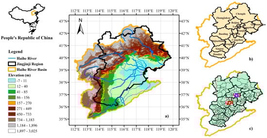
Figure 1.
The Haihe River basin and the Jingjinji region. (a) The Haihe River Basin; (b) Cities in the Jingjinji region; (c) Counties in the Jingjinji region (the red and purple boundaries indicate the Xiong’an New District and Tongzhou District, respectively).
Rapid industrialization, urbanization, a population explosion, and socio-economic development within the Jingjinji region have resulted in disturbances of the water cycles being the strongest worldwide [19,20,21]. The region is extremely thirsty: precipitation has decreased while ET has increased since the 1980s, resulting in a significant reduction in local water resources. The water resources here have been over-exploited, resulting in a series of environmental problems, such as the drying-up of river reaches, shrinking of wetlands and lakes, severe water pollution, decline of groundwater tables, ground subsidence, and seawater intrusion. These problems have become major bottlenecks slowing regional sustainable development [22,23,24].
Figure 1b,c shows all cities and counties in the Jingjinji region. In general, the county, district, and county-level city (for simplicity, referred to as county) are the third-level administration division in China, following the province (first level) and city (second level). The main information on all counties in the Jingjinji region is summarized in Table 1. According to statistical data from 2015, the total population is 111 million in the entire region, with 21.71, 15.47, and 74.25 million in Beijing, Tianjin, and Hebei, respectively, and the total gross domestic product (GDP) is 6.9 trillion CNY (~1.0 trillion USD), with 2.3, 1.6, and 3.0 trillion CNY in Beijing, Tianjin, and Hebei, respectively. In total, there are 13 cities or 200 counties (see Table S1 and Figure S1) in the Jingjinji region to date.

Table 1.
Information on counties in the Jingjinij region.
2.2. Data
Data from multiple sources were collected for this study:
- A 61-year (1952–2012) long-term land surface hydrologic dataset for China with a 0.25° spatial resolution, which was produced by Institute of Geographic Sciences and Natural Resources Research (IGSNRR) of Chinese Academy of Sciences (hereinafter referred to as the IGSNRR dataset, http://hydro.igsnrr.ac.cn/public/vic_outputs.html, which is available in English, and data are freely available), provided estimates of precipitation, actual ET, and runoff. Runoff (or streamflow) is surface plus base flow and is assumed to represent the natural water resources. The actual ET and runoff estimates included in the IGSNRR dataset are derived from the Variable Infiltration Capacity (VIC) model [25] using gridded daily meteorological observations of rainfall, temperature, and wind speed [26]. The model has been shown to be able to reproduce the hydrographs over the major river basins in China, including two representative gauge stations (Luanxian and Guantai) in the Haihe River Basin. Other IGSNRR outputs such as actual ET and soil moisture have also been compared with several observational or observational-based data products to demonstrate their accuracy [26].
- The data on water supply, consumption structures and water use efficiency for Beijing, Tianjin, and Hebei during 2000–2017 at provincial level were collected from the “China Water Resources Bulletins (2000–2017),” as shown in Figure 2. This paper focuses on the renewable surface and ground water as well as the water from the WDP, which in 2017 accounted, respectively, for 9.1%, 42.0%, and 22.3% of the total water supply in Beijing, 32.4%, 10.2%, and 36.7% in Tianjin, and 25.6%, 47.4%, and 7.2% in Hebei. The agricultural, industrial, domestic, and environmental water consumptions vary greatly among Beijing (12.9%, 8.8%, 46.3%, and 32.1%), Tianjin (38.9%, 20.0%, 22.2%, and 18.9%), and Hebei (69.4%, 11.2%, 14.9%, and 4.5%).
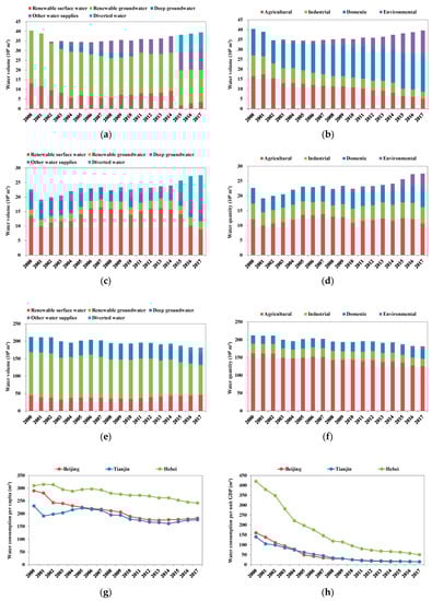 Figure 2. Water supply, consumption structures, and water use efficiency in the Jingjinji region. (a) Water supply in Beijing; (b) Water consumption in Beijing; (c) Water supply in Tianjin; (d) Water consumption in Tianjin; (e) Water supply in Hebei; (f) Water consumption in Hebei; (g) Water consumption per capita; (h) Water consumption per unit GDP.
 - The current socio-economic data used in the study were collected from the “Beijing District Statistical Yearbook (2016),” “Beijing Statistical Yearbook (2016),” “Tianjin Statistical Yearbook (2016),” and “Hebei Economic Yearbook (2016).” The future socio-economic scenarios are based on the “Outline of the Thirteenth Five-Year Plans for National Economic and Social Development (2016–2020),” “General Plans for Land Use,” and “General Plans for City” of cities and counties in Beijing, Tianjin, and Hebei (see Section 3.3. for details). The county boundaries were collected from the Geographical Information Monitoring Cloud Platform (http://www.dsac.cn/, which is in Chinese only).
- The data for major water diversion projects (WDP) were collected from the Bureau of South-to-North Water Transfer of Planning, Design and Management, Ministry of Water Resources, PRC. Table 2 summarizes the information on the major WDP to the Jingjinji region, including the current and future scenarios. In general, these WDP take full advantage of the abundant water resources of the Yangtze River and the geographic proximity of the Yellow River, respectively. Water shortages in northern China stimulated China to launch the South-to-North Water Diversion Project (SNWDP), which includes the East, Middle, and West routes. According to the “General Plan on South-to-North Water Diversion Project” and the “Integrated Plan on Haihe River Basin (2012–2030),” the SNWDP will supply a total of 6.15 × 10⁹ m3 of water to the Jingjinji region in 2020 through the Middle Route (Phase I) and East Route (Phase II) and 8.58 × 10⁹ m3 in 2030 through the Middle Route (Phases I and II) and East Route (Phases II and III). The total water diversion capacities of the WDP will reach 7.4 × 10⁹ m3 recently and are expected to 12.0 × 10⁹ m3 in the future. It should be noted that only the WDP bringing water into the Jingjinji region from outside the Jingjinji region is considered here, and intra-basin transfers are not considered. These intra-basin transfers have the potential to at least partially compensate for the county level differences noted here, at least for counties impacted by such transfers.
Table 2. Information on the major water diversion projects to the Jingjinji region.
3. Methodology
To assess water resource security and map its spatial distribution at county level in the Jingjinji region, an assessment framework is developed consisting of four major procedures (see Figure 3). These are the estimation of total water resources, establishment of assessment indicators, projection (prediction outcomes) of future scenarios, and scenario construction and analysis. For simplicity, the total water resources in a county can be regarded as the sum of natural renewable and anthropogenic water resources of that county.
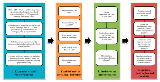
Figure 3.
Framework for mapping the distribution of water resource security at county level.
3.1. Estimation of Total Water Resources
To use the IGSNRR dataset for a county, the following steps are taken: (1) the original 0.25° × 0.25° gridded datasets of daily precipitation, actual ET, and runoff are converted into annual ones; (2) the missing data at the edges of the study area are filled by the moving average method with a window size of 10; (3) all gridded data is subsampled by the nearest neighbor method from 0.25° × 0.25° into 0.01° × 0.01° spatial resolution for application, because the original spatial resolution is too large to be directly used for some small counties; and (4) the newly generated 0.01° × 0.01° gridded data are filtered by the square matrix average method with a window size of 25 × 25; (5) the precipitation, actual ET, and runoff (natural water resources) in each county are the accumulation of the 0.01° × 0.01° gridded data within the county boundary. We have provided details of the downscaling procedure and demonstrated its reliability in the supplementary file (see Figure S2).
In this study, allocations of the anthropogenic water resources are derived as follows: (1) the plan for the allocation of water resources to counties of Hebei from the Middle Route (Phase I) of the SNWDP is applied, and that to counties of Beijing and Tianjin from the route is based on the population distribution; (2) the water resources from the other WDP are assumed to be transferred to the counties within the cities, along which the routes of the WDP are built, and also allocated based on the population distribution; and (3) the total water quantities transferred from all the WDP are assumed equal to their planning water diversion capacities.
Note that although there are water resources from other supplies in this region, such as from sea water desalination, they are not considered in this paper because of the limited water quantity that can be gained or the requirements for their large-scale production that cannot be met currently.
3.2. Establishment of Assessment Indicators
In this study, the concepts of water-crowding and use-to-availability indicators [27,28] are used for measuring the population- and demand-driven water scarcity at the county level, which are widely used because they are simple and intuitive [29]. In general, the water-crowding indicator or the Falkenmark’s indicator is the water availability per year per capita (WAPOP), and the use-to-availability indicator denotes the water scarcity index (WSI), that is, ratio of water withdrawal to availability. Here, with consideration of the GDP-driven water scarcity, the water availability per unit (10,000 CNY) GDP (WAGDP) is included also as a water-crowding indicator, and two WSIs are calculated based on both the population () and GDP (). The indicators are defined as
where is the available water resources of a county (with or without the WDP); is the population of a county; GDP is the GDP of a county; and
and are the social water productivities (or water use efficiencies) in terms of water consumptions per capita and per unit GDP.
Threshold values to determine the water resource security are set as follows. For , the water stress, high water stress, and absolute scarcity occur when the values are below 1700, 1000, and 500 m3, respectively [9,13,14,29]. For , a uniform threshold value cannot be determined because it is closely related to the water consumption (or industry) structure, resulting in big differences among regions. For and , high and extreme stresses occur when the values are over 0.4 and 1 [4,9,12,13,27,30,31].
With regard to and , the observed values of 2017 in Beijing, Tianjin, and Hebei are applied to the respective counties in both current and future scenarios for simplicity; that is, are 182 m3, 176 m3, and 242 m3, and are 14 m3, 15 m3, and 50 m3 in the counties of Beijing, Tianjin, and Hebei, respectively ( of Hebei is higher than those of Beijing and Tianjin because its dominant water consumption is agricultural use). While considerable improvement in water use efficiency has been made over the past two decades (see Figure 2g,h), the scope for future improvements (in an absolute sense) seems limited. Due to the improvement in water use efficiency, the differences in and are likely to be significantly reduced also, and the constant values within each sub-region are assumed to reflect well the counties in the Jingjinji region.
Moreover, an indicator that reflects the carrying capacity for both population and GDP (composite carrying capacity) is proposed, which can be classified as satisfying the water resource requirements of either “Both,” “Only Population,” “Only GDP,” or “Neither.” The composite indicator is calculated based on the values of the two WSI indicators with respect to their thresholds. The thresholds for both and are set as 0.7 in order to determine which class a county belongs to, allowing for a 30% environmental flow requirement [11,27,28,32]. With the composite indicator, the counties which suffer water scarcity due to the heavy burden of population or GDP can be clearly identified.
3.3. Projection of Future Scenarios on Water Resource Security
We consider two future scenarios for discussion—one is under the regional synergistic development, and the other is under climate change. These are the potentially significant factors influencing water resource security throughout the Jingjinji region.
3.3.1. Regional Synergistic Development
The principles and methods of prediction on socio-economic development are as follows:
- (1)
- The year 2015 is considered as the current scenario, and the year 2030 as the future scenario, when the regional synergistic development of the Jingjinji region is more mature;
- (2)
- The data on population and GDP at county level in the current scenario are collected from the 2015 Statistical Yearbooks of Beijing, Tianjin, and Hebei;
- (3)
- The relevant plans of cities or counties are referred to for their target values/growth rates on the population and GDP in/until 2020 and 2030; it should be noted that the plans released after 2015 are used, which consider the regional synergistic development of the Jingjinji region;
- (4)
- If a target value/growth rate can be applied for a city from the relevant plans, the future scenario of the city can be predicted, and then the proportional allocation for the future scenario is taken on the basis of the current scenario for the counties within the city;
- (5)
- If a county has its target value/growth rate on the population and GDP in/until 2020 and 2030, the value/rate will be applied directly; and otherwise, the growth rates are assumed to be the average growth rate of the city that the county belongs to, and the growth rates of GDP are assumed to be 6.0% during 2020–2030 (which is the long-term annual average target growth rate of GDP set by the Chinese government);
- (6)
- In particular, for Beijing City Sub-Center (partial area of Tongzhou District) and Xiong’an New District (which mainly includes Xiong County, Rongcheng County, Anxin County) (see Figure 1c), the target population and the GDP per area (six main districts of Beijing, that is, Dongcheng, Xicheng, Haidian, Chaoyang, Fengtai, and Shijingshan) are applied in the future scenario.
Figure 4 shows the population and GDP of 13 cities in the Jingjinji region in 2015 (current scenario), 2020, and 2030 (future scenario). The total population and GDP are projected as 123.6 million and 19.9 trillion CNY (~2.88 trillion USD) in the future scenario (see Figures S3 and S4 for the current and future distributions of population and GDP).
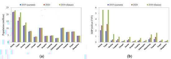
Figure 4.
Current and future socio-economic developments in the Jingjinji region. (a) Population; (b) GDP.
3.3.2. Climate Change
The climate elasticity of runoff [33,34] is used to quantify the possible climate change impacts on the runoff across the 200 counties in the Jingjinji region. As recommended in previous studies, the non-parametric approach to estimate the precipitation elasticity of runoff () can be written as
where and are the annual runoff and precipitation and and are the annual mean runoff and precipitation. With the estimator in Equation (5), as well as the newly generated data for counties over 1952–2012, the spatial distribution of runoff sensitivity to change in precipitation at county level across the Jingjinji region can be illustrated.
3.4. Scenario Construction and Analysis
For analysis, the long-term annual mean natural water resources are calculated at the county level in the Jingjinji region; as well as for the typical dry (2005), normal (2010), and wet years (2012). These typical years correspond to the exceedance probability of roughly 75%, 50%, and 25%. They are selected on the basis of the historical precipitation (1952–2012) over the Jingjinji region. Current and future scenarios, with or without the WDP, are considered with the assessment indicators (i.e., two water-crowding indicators, two use-to-availability indicators, and one composite indicator). Scenario combinations can therefore be calculated and mapped with the geographic information system (GIS) for analysis and discussion.
4. Results and Discussion
4.1. Quantity and Distribution of Water Resources
The precipitation, runoff, and actual ET in the Jingjinji region over 1952–2012 are shown in Figure 5. The runoff has been decreasing from the beginning of the period. The annual mean natural water resources are 104 mm (23.6 × 10⁹ m3), while for the typical dry, normal, and wet years, the water resources are 72 mm, 86 mm, and 123 mm (16.3 × 10⁹ m3, 19.5 × 10⁹ m3, and 27.9 × 10⁹ m3), respectively. Figure 6 shows the spatial distribution of annual mean precipitation, runoff, actual ET, and runoff coefficient (see Figure S5 for the spatial distribution in the typical years). On average, the annual precipitation, runoff, actual ET, and runoff coefficient have ranges of 336–717 mm, 23–251 mm, 289–601 mm, and 0.05–0.44, respectively. Note that the high runoff coefficient south of Tianjin (38 to 39° N, 116.5 to 118° E) is due to increased base flow in this region produced by the VIC model.
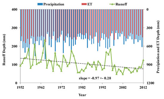
Figure 5.
Precipitation, runoff, and actual evapotranspiration in 1952–2012 in the Jingjinji region.
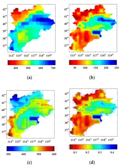
Figure 6.
Spatial distribution of annual mean precipitation, runoff, actual evapotranspiration, and runoff coefficient in the Jingjinji region. (a) Precipitation; (b) Runoff; (c) Evapotranspiration; (d) Runoff coefficient.
Figure 7 shows the annual mean natural water resources at county level in the Jingjinji region (see Figures S6 and S12 for the current and future distributions in the typical years). Table 3 summarizes the characteristic values for different scenarios. The northeastern region has greater natural water resources than counties in the other parts of the region. This includes most of the counties in Qinhuangdao, Tangshan, Tianjin, and Beijing, as well as some of the counties in Chengde and Cangzhou. The county level natural water resources have maximum values of 224 mm, 221 mm (annual mean and dry year for Jinghai of Tianjin), 271 mm (normal year for Qinglong of Qinhuangdao), and 528 mm (wet year for Funing of Qinhuangdao). The minimum natural water resources are estimated to be only 36 mm (annual mean for Wanquan of Zhangjiakou), 21 mm (dry year for Luquan of Shijiazhuang), 18 mm (normal year for Gaoyang of Baoding), and 24 mm (wet year for Raoyang of Hengshui) (noting that the minimum water resources for the selected dry year (2005) is higher than the selected normal year (2010), due to the different distribution of rainfall). The difference in natural water resources between counties can reach around ten times. The natural water resources in over half of the total counties in the region are below 100 mm (numbers of counties are 114, 155, 143, and 110 for the annual mean and typical years).
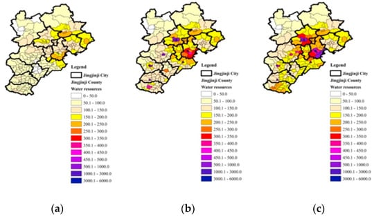
Figure 7.
Distribution of annual mean water resources at county level (unit: mm). (a) Annual mean without WDP; (b) Annual mean with WDP, current; (c) Annual mean with WDP, future.
Table 3.
Characteristic values for different scenarios.
After supplementation by the WDP, the total annual mean water resources (natural plus anthropogenic) increase to 135 mm (30.6 × 10⁹ m3), while for the typical years they increase to 103 mm, 117 mm, and 154 mm (23.4 × 10⁹ m3, 26.6 × 10⁹ m3, and 35.0 × 10⁹ m3). This corresponds to a relative increase of between 25% (typical wet year) to 44% (typical dry year). In particular, there is an obvious increase in total water resources in the southern and central counties. In terms of the annual mean as well as typical years, the numbers of counties, whose total water resources are below 100 mm, decrease sharply to 36, 91, 73, and 63 (decrease by 68%, 41%, 49%, and 43% in comparison with those without the WDP). Even so, there are still areas whose total water resources are very limited, and these areas shift northward because the water from the WDP is largely diverted to the southern region. The total water resources for the current scenario with the WDP operating at full capacity are 3817 mm, 3824 mm, 3750 mm, and 3891 mm in Heping of Tianjin (a very high population density area) in the annual mean and typical years, respectively. The minimum total water resources are estimated to be 36 mm (annual mean for Wanquan of Zhangjiakou), 22 mm (dry year for Qiaoxi of Zhangjiakou), 40 mm (normal year for Fuping of Baoding), and 27 mm (wet year for Qiaoxi of Zhangjiakou).
4.2. Assessment Based on Current Scenarios
The distributions of water resource security are firstly mapped using the assessment indicators in the Jingjinji region for the current scenarios.
4.2.1. Water Availability Per Capita
Figure 8 shows the distribution of annual mean water availability per capita (see Figure S7 for the distribution in typical years). As shown in Table 3, annual mean values are 213 m3 and 279 m3 before and after supplementation by the WDP, taking the Jingjinji region as a whole. is larger in the northwest than in the southeast, which are exactly the opposite of the population distribution (see Figure S3). The maximum can reach 2089 m3, 1263 m3 (annual mean and dry year for Xinglong of Chengde), 1777 m3 (normal year for Qinglong of Qinhuangdao), and 3149 m3 (wet year for Xinglong of Chengde). Before and after supplementation by the WDP, the minimum increase from 3.8 m3 (annual mean for Heping of Tianjin), 2.6 m3 (dry year for Qiaoxi of Shijiazhuang), 1.9 m3, and 5.9 m3 (normal and wet years for Heping of Tianjin) to 35.8 m3 (annual mean for Lubei of Tangshan), 23.8 m3 (dry year for Qiaoxi of Zhangjiakou), 22.2 m3 (normal year for Lubei of Tangshan), and 28.7 m3 (wet year for Qiaoxi of Zhangjiakou). The numbers of counties, whose are below 100 m3, reduce drastically from 66, 114, 89, and 82 to 12, 26, 21, and 21, respectively, in terms of the annual mean and typical years after supplementation by the WDP, and they are mainly concentrated in the 6 main districts of Beijing and several counties of Hebei. of 36, 24, 27, and 45 counties (18%, 12%, 13.5%, and 22.5% of the total number) are over 1000 m3 (threshold value of high water stress). Among them, of only 13, 4, 11, and 14 counties (6.5%, 2%, 5.5%, and 7% of total number) are over 1700 m3 (threshold value of water stress) in the annual mean and typical years, even after supplementation by the WDP.
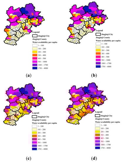
Figure 8.
Distribution of water availability per capita at county level (unit: m3). (a) Annual mean, without WDP, current; (b) Annual mean without WDP, future; (c) Annual mean with WDP, current; (d) Annual mean with WDP, future.
As an application example, the population affected by water scarcity and water deficit under varying thresholds in term of can be calculated with the distribution. As shown in Figure 9a,b, when the thresholds in term of are 100 m3, 200 m3, 300 m3, 400 m3, and 500 m3, before and after supplementation by the WDP, the population affected by water scarcity in the annual mean are decreased from 44.5 million, 82.0 million, 93.2 million, 97.2 million, and 100.1 million to 15.6 million, 56.4 million, 86.6 million, 95.2 million, and 98.9 million, respectively; and the water deficits are decreased from 2.35 billion m3, 9.22 billion m3, 18.00 billion m3, 27.51 billion m3, and 37.41 billion m3 to 0.51 billion m3, 4.32 billion m3, 11.59 billion m3, 20.67 billion m3, and 30.43 billion m3, respectively.
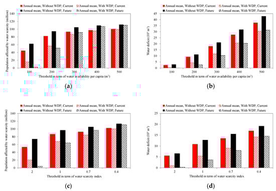
Figure 9.
Population affected by water scarcity and water deficit. (a) Relation between threshold in term of water availability per capita and population affected by water; (b) Relation between threshold in term of water availability per capita and water deficit; (c) Relation between threshold in term of water scarcity index based on population and population affected by water; (d) Relation between threshold in term of water scarcity index based on population and water deficit.
4.2.2. Water Availability per Unit GDP
Figure 10 shows the distribution of annual mean water availability per unit GDP (see Figure S8 for the distribution in typical years). As shown in Table 3, annual mean values are 35 m3 and 46 m3 for the whole Jingjinji region before and after supplementation by the WDP. is larger in the northwest than in the southeast, which are exactly the opposite of the GDP distribution (see Figure S3). The maximum can reach 792 m3, 544 m3 (annual mean and dry year for Fengning of Chengde), 1026 m3, and 1607 m3 (normal and wet years for Qinglong of Qinhuangdao). Before and after supplementation by the WDP, the minimum increase from 0.2 m3 (annual mean for Heping of Tianjin), 0.1 m3 (dry year for Xicheng of Beijing), 0.1 m3, and 0.3 m3 (normal and wet years for Heping of Tianjin) to 2.2 m3, 2.0 m3, 2.1 m3, and 2.3 m3 (annual mean and three typical years for Xicheng of Beijing), respectively. The numbers of counties, whose are below 20 m3, reduce drastically from 51, 70, 68, and 52 to 21, 27, 22, and 16, respectively, in the annual mean and typical years after supplementation by the WDP, mainly concentrated in the main districts of Beijing and Tianjin as well as several counties of Hebei.
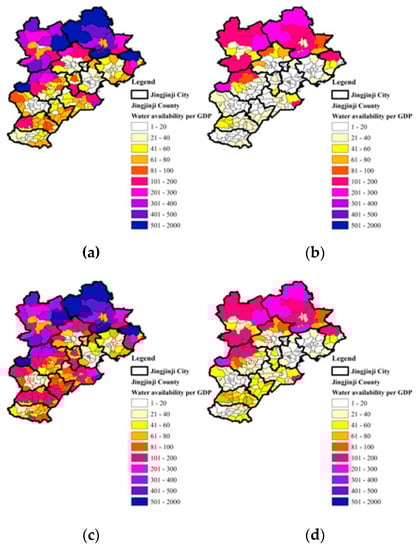
Figure 10.
Distribution of water availability per unit GDP at county level (unit: m3). (a) Annual mean without WDP, current; (b) Annual mean without WDP, future; (c) Annual mean with WDP, current; (d) Annual mean with WDP, future.
4.2.3. Water Scarcity Index Based on Population
Figure 11 shows the distribution of WSI based on population with respect to the annual mean (see Figure S9 for the distribution in typical years). As shown in Table 3, for the whole Jingjinji region are 1.04 and 0.79 in the annual mean before and after supplementation by the WDP. Population-driven water scarcity is the dominant influence for most counties even with the WDP, which are mainly located in the middle and southern region. The ranges of in the annual mean and typical years before and after supplementation by the WDP are narrowed significantly from 0.12–46.66, 0.19–92.60, 0.14–94.67, and 0.08–29.87 to 0.12–6.76, 0.19–10.18, 0.14–10.91, and 0.08–8.43. The numbers of counties whose are below 1.0 (threshold value of extreme water stress) increase from 61, 45, 56, and 73 to 91, 60, 75, and 94 without and with the WDP in the annual mean and typical years, respectively. Among them, the numbers of counties whose are below 0.4 (threshold value of high water stress) are only 31, 19, 26, and 37 (15.5%, 9.5%, 13%, and 18.5% of total number) after supplementation by the WDP.
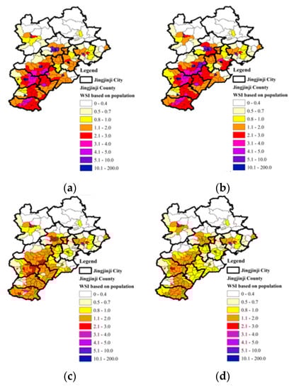
Figure 11.
Distribution of water scarcity index (WSI) based on population at county level. (a) Annual mean without WDP, current; (b) Annual mean without WDP, future; (c) Annual mean with WDP, current; (d) Annual mean with WDP, future.
As an application example, the population affected by water scarcity and water deficit under varying thresholds in term of can be calculated with the distribution. As shown in Figure 9c,d, when the thresholds in term of are 2.0, 1.0, 0.7, and 0.4, before and after supplementation by the WDP, the population affected by water scarcity in the annual mean are decreased from 53.6 million, 86.6 million, 92.6 million, and 102.3 million to 20.5 million, 67.8 million, 84.5 million, and 100.3 million, respectively; and the water deficits are decreased from 5.57 billion m3, 10.85 billion m3, 13.52 billion m3, and 16.99 billion m3 to 1.00 billion m3, 5.43 billion m3, 9.05 billion m3, and 14.18 billion m3, respectively.
4.2.4. Water Scarcity Index Based on GDP
Figure 12 shows the distribution of WSI based on GDP in the annual mean (see Figure S10 for the distribution in typical years). As shown in Table 3, values are 0.82 and 0.62 for the whole Jingjinji region in the annual mean before and after supplementation by the WDP. GDP-driven water scarcity is non-significant in most counties before supplementation by the WDP, and it is further relieved after supplementation. Ranges of narrow remarkably from 0.06–88.40, 0.08–120.09, 0.05–179.36, and 0.03–56.58 to 0.05–6.33, 0.08–7.89, 0.05–6.71, and 0.03–6.53 in the annual mean, and typical years before and after supplementation by the WDP. The numbers of counties whose are below 1.0 increase remarkably from 101, 65, 91, and 106 to 145, 125, 129, and 142 without and with the WDP in the annual mean and typical years, respectively. Among them, the numbers of counties in the annual mean and typical years, whose are below 0.4 are 55, 38, 47, and 60 (representing 27.5%, 19%, 23.5%, and 30% of the total number) after supplementation by the WDP.
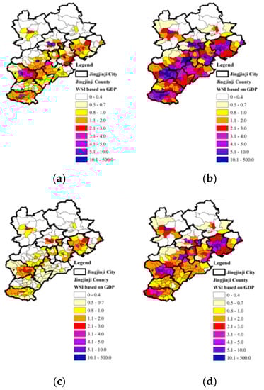
Figure 12.
Distribution of water scarcity index (WSI) based on GDP at county level. (a) Annual mean without WDP, current; (b) Annual mean without WDP, future; (c) Annual mean with WDP, current; (d) Annual mean with WDP, future.
4.2.5. Composite Carrying Capacity
Figure 13 shows the distribution of composite carrying capacity in the annual mean (see Figure S11 for the distribution in typical years). Before and after supplementation by the WDP, in both the annual mean and typical years, very few counties can carry “Only Population”; several counties can carry “Only GDP,” and the numbers of counties increase significantly from 26, 14, 21, and 20 to 56, 53, 56, and 51, respectively; the numbers of counties that can carry “Both” increase slightly from 45, 31, 39, and 53 to 54, 37, 44, and 63, respectively; and the numbers of counties that can carry “Neither” obviously reduce from 126, 149, 136, and 123 to 86, 103, 95, and 80, respectively.
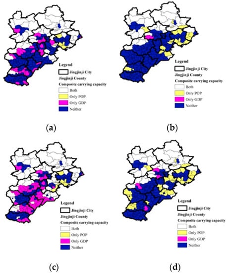
Figure 13.
Distribution of composite carrying capacity at county level. (a) Annual mean without WDP, current; (b) Annual mean without WDP, future; (c) Annual mean with WDP, current; (d) Annual mean with WDP, future.
4.3. Assessment on Regional Synergistic Development
The distributions of water resource security in the Jingjinji region are then mapped according to the assessment indicators arising from projecting the future scenarios of regional synergistic development. The mapping of the annual mean is shown in Figure 7,Figure 8, Figure 10, Figure 11, Figure 12 and Figure 13 (see Figures S12–S17 for the distributions in typical years).
As shown in Table 3, the water resources in total (natural plus anthropogenic) increase further to 154 mm, 122 mm, 137 mm, and 174 mm (35.0 × 10⁹ m3, 27.7 × 10⁹ m3, 31.0 × 10⁹ m3, and 39.4 × 10⁹ m3) for the annual mean and typical years, respectively (corresponding to relative increases of 49%, 70%, 59%, and 41% in comparison to the natural resources). In particular, in Heping of Tianjin, after supplementation by the WDP, the maximum values increase further to 5901 mm, 5908 mm, 5834 mm, and 5975 mm in the annual mean and typical years. The total water resources in southern counties of the region increase more: the numbers of counties whose total water resources are below 100 mm decrease considerably to 21, 40, 36, and 28 (representing relative decrease by 42%, 56%, 51%, and 56% in comparison with the current scenario with the WDP) in the annual mean and typical years, respectively.
Taking the Jingjinji region as a whole, the future value in the annual mean is estimated to be 290 m3 and the future to be 0.76 with the WDP. This represents a slight improvement in comparison with the current (279 m3) and (0.79) values; the future value is estimated to be 18 m3 and the future 1.67, which will be much worse than the current (46 m3) and (0.62) values. In comparison with the current scenario with the WDP, the characteristic values of and as well as the number of counties within different ranges change much less; whereas, the characteristic values of and as well as the number of counties within different ranges change considerably. In the annual mean and typical years, the maximum values decrease (to 290 m3, 199 m3, 266 m3, and 417 m3) and the maximum values increase substantially (to 13.82, 22.69, 16.11, and 18.79). The numbers of counties whose values are below 20 m3 increase to 75, 89, 82, and 71 (relative increase by 257%, 230%, 273%, and 344%); and those whose are below 1.0 decrease to 60, 43, 58, and 64 (decrease by 59%, 66%, 55%, and 55%).
As shown in Figure 9, when the thresholds in term of are 100 m3, 200 m3, 300 m3, 400 m3, and 500 m3, before and after supplementation by the WDP, the population affected by water scarcity in the annual mean are decreased from 62.2 million, 94.3 million, 104.6 million, 109.2 million, and 111.5 million to 2.4 million, 51.1 million, 91.3 million, 106.9 million, and 110.1 million, respectively; and the water deficits are decreased from 2.89 billion m3, 11.10 billion m3, 21.07 billion m3, 31.76 billion m3, and 42.80 billion m3 to 0.07 billion m3, 2.70 billion m3, 10.35 billion m3, 20.44 billion m3, and 31.33 billion m3, respectively. When the thresholds in term of are 2.0, 1.0, 0.7, and 0.4, before and after supplementation by the WDP, the population affected by water scarcity in the annual mean are decreased from 74.1 million, 96.6 million, 105.2 million, and 113.4 million to 4.1 million, 64.3 million, 96.6 million, and 110.8 million, respectively; and the water deficits are decreased from 6.56 billion m3, 12.75 billion m3, 15.52 billion m3, and 19.17 billion m3 to 0.29 billion m3, 3.64 billion m3, 7.99 billion m3, and 14.54 billion m3, respectively.
In comparison with the current scenario with the WDP, the composite carrying capacity of future water resources with respect to population improves while the high-speed economic development in more extensive counties cannot be carried although more water is diverted by the WDP. Major improvements in water-saving technologies (with particular emphasis on the agricultural sector), vigorous replacement of industries from high to low water consumption, as well as water from other supplies that can be applied on a large scale are greatly needed to achieve further economic development.
4.4. Runoff Sensitivity to Climate Change
Figure 14 shows the distribution of precipitation elasticity of runoff at county level, where ranges from 1.16 to 3.44. The absolute value of is relatively large in the northern, western and southern counties, indicating that the runoff of these areas is more sensitive to change in precipitation. Particularly, much more attention should be paid to the southern counties under the climate change context because of the limited and vulnerable water resources in those counties.
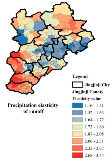
Figure 14.
Distribution of precipitation elasticity of runoff at county level.
5. Conclusions
To adapt to the significantly changing context, this paper develops an assessment framework to assess water resource security across 200 counties in the Jingjinji region, which is subject to the most serious water resource shortage in China. Major conclusions can be summarized as follows:
- The distributions of water resources at county level are mapped. The natural water resources (total estimated as 104 mm in the annual mean) are distributed unevenly in the Jingjinji region, exhibiting abundant quantity in the northeastern counties (with a maximum of 224 mm), while there are an extremely limited quantity in the other counties (with a minimum of 36 mm), and over half of the counties have quantity below 100 mm. After supplementation by the current WDP, the annual mean water resources in total are estimated to be 135 mm, with a 30% increase than the natural ones.
- The distributions of water resource security at county level with two water-crowding indicators are mapped. Both water availability per capita () and per unit (10,000 CNY) GDP () are larger in the northwest than in the southeast counties. Before and after supplementation by the WDP, the annual mean values are 213 m3 and 279 m3, and annual mean values are 35 and 46 m3 for the whole Jingjinji region, with ranging spatially from 3.8 (35.8) m3 to 2089 m3 and ranging from 0.2 (2.2) m3 to 792 m3.
- The distributions of water resource security at county level with two use-to-availability indicators are mapped. The water scarcity index based on population () and GDP () are calculated at county level to determine the distribution of water resource security. Before and after supplementation by the WDP, the annual mean values are 1.04 and 0.79, and annual mean values are 0.82 and 0.62 for the whole Jingjinji region, with ranging spatially from 0.12 to 46.66 (6.76) and ranging from 0.05 to 88.4 (6.33).
- The distributions of water resource security at county level with one composite indicator are mapped. Whether the water resources can carry the population and GDP at the county level can be identified by the composite carrying capacity (which is classified as “Both,” “Only Population,” “Only GDP,” and “Neither” the water resources can carry). It is observed that in general, the northern counties can carry both population and GDP, the middle and southern counties can carry only GDP or neither of them, indicating that the dominance influence on the carrying capacity is the population in current scenarios.
- The distributions of water resource security at county level for the regional synergistic development are mapped. The total annual mean water resources (natural plus anthropogenic) increase further to 154 mm, with a 49% increase above the natural resources. The future values of (290 m3) and (0.76) improve slightly, while the future (18 m3) and (1.67) values become worse than the current and values for the whole Jingjinji region, which are all distributed unevenly among counties. The carrying capacity of future water resources improves for population. However, it cannot drive the continued high-speed economic development in many middle and southern counties unless there are major improvements in water-saving technologies (with particular emphasis on the agricultural sector) and industries are replaced vigorously from high to low water consumption, as well as water from other supplies needing to be applied on a large scale.
- The distribution of climate elasticity of runoff at county level is mapped. The runoff is more sensitive and vulnerable in the southern counties, where much more attention should be paid on the issues of water resource security under the climate change context.
These achievements can help policy makers and managers to implement the refined water resource management—(1) locating the counties of water scarcity at different risk levels, (2) estimating the population affected by water scarcity and water deficit, (3) optimizing regional water resources allocation, and evaluating the rationality of route and distribution of planned water diversion projects, (4) determining the carrying capacity of water resources for socio-economic development and guiding population transfer and industrial restructuring for regional synergistic development, and (5) proposing more effective policies and strategies. Because of the applicability, the proposed assessment framework for mapping the distribution of water resource security at county level can also be applied in other similar regions.
Future work could beneficially focus on predicting water withdrawals from different sectors of different counties (in place of the social water productivities used in this study), analyze the possible impacts of climate change on the water resources (based on the climate scenarios reported by the Intergovernmental Panel on Climate Change), and further explore the water resource security at county level in this region.
Supplementary Materials
The following are available online at https://www.mdpi.com/2071-1050/11/22/6463/s1.
Author Contributions
Conceptualization, X.L. and D.Y.; Methodology, X.L., D.Y., X.Z., B.F.W.C., R.Z. and F.X.; Validation, X.Z., B.F.W.C., R.Z., L.Z., F.X. and Q.W.; Formal analysis, X.L. and D.Y.; Investigation, X.L., D.Y. and D.G.; Resources, J.L. and X.M.; Data curation, X.Z. and D.G.; Writing—original draft preparation, X.L. and D.Y.; Writing—review and editing, X.Z., B.F.W.C. and A.J.J.; Visualization, X.L. and D.Y.; Supervision, J.L.; Project administration, J.L.; Funding acquisition, X.L. and J.L.
Funding
This study is supported by the National Key Research and Development Program of China (2016YFC0401401) and the National Natural Science Foundation of China (51609256, 51609122, 51522907, 51739011, and 51569026). Partial support is also from the Young Elite Scientists Sponsorship Program by the China Association for Science and Technology (2017QNRC001).
Acknowledgments
The authors would like to thank the editor and two anonymous reviewers for their in-depth reviews and constructive comments, which have led to substantial improvements of the paper.
Conflicts of Interest
The authors declare no conflict of interest.
References
- Zhang, S.; Fan, W.; Yi, Y.; Zhao, Y.; Liu, J. Evaluation method for regional water cycle health based on nature-society water cycle theory. J. Hydrol. 2017, 551, 352–364. [Google Scholar] [CrossRef]
- CPC Central Committee and State Council. The decision on accelerating the reform and development of water conservancy. China Water Conserv. 2011, 4, 1–4. (In Chinese) [Google Scholar]
- State Council. Opinions on the implementation of the “Strictest Water Resource Management System”. China Water Resour. News. 2012. (In Chinese) [Google Scholar]
- Vörösmarty, C.J.; Green, P.; Salisbury, J.; Lammers, R.B. Global water resources vulnerability from climate change and population growth. Science 2000, 289, 284–288. [Google Scholar] [CrossRef] [PubMed]
- Milly, P.C.; Dunne, K.A.; Vecchia, A.V. Global pattern of trends in streamflow and water availability in a changing climate. Nature 2005, 438, 347–350. [Google Scholar] [CrossRef] [PubMed]
- Piao, S.; Ciais, P.; Huang, Y.; Shen, Z.; Peng, S.; Li, J.; Zhou, L.; Liu, H.; Ma, Y.; Ding Y., P. The impacts of climate change on water resources and agriculture in China. Nature 2010, 467, 43–51. [Google Scholar] [CrossRef]
- Haddeland, I.; Heinke, J.; Biemans, H.; Eisner, S.; Flörke, M.; Hanasaki, N.; Konzmann, M.; Ludwig, F.; Masaki, Y.; Schewe, J.; et al. Global water resources affected by human interventions and climate change. Proc. Natl. Acad. Sci. USA 2014, 111, 3251–3256. [Google Scholar] [CrossRef]
- Liu, C.; Zheng, H. South-to-north water transfer schemes for China. Int. J. Water Resour. Dev. 2002, 18, 453–471. [Google Scholar] [CrossRef]
- Oki, T.; Kanae, S. Global hydrological cycles and world water resources. Science 2006, 313, 1068–1072. [Google Scholar] [CrossRef]
- Oki, T.; Agata, Y.; Kanae, S.; Saruhashi, T.; Yang, D.; Musiake, K. Global assessment of current water resources using total runoff integrating pathways. Hydrol. Sci. J. 2001, 46, 983–995. [Google Scholar] [CrossRef]
- Hanasaki, N.; Kanae, S.; Oki, T.; Masuda, K.; Motoya, K.; Shirakawa, N.; Shen, Y.; Tanaka, K. An integrated model for the assessment of global water resources–Part 1: Model description input meteorological forcing. Hydrol. Earth Syst. Sci. 2008, 12, 1007–1025. [Google Scholar] [CrossRef]
- Hanasaki, N.; Kanae, S.; Oki, T.; Masuda, K.; Motoya, K.; Shirakawa, N.; Shen, Y.; Tanaka, K. An integrated model for the assessment of global water resources–Part 2: Applications and assessments. Hydrol. Earth Syst. Sci. 2008, 12, 1027–1037. [Google Scholar] [CrossRef]
- Wada, Y.; Van Beek, L.P.H.; Bierkens, M.F. Modelling global water stress of the recent past on the relative importance of trends in water demand and climate variability. Hydrol. Earth Syst. Sci. 2011, 15, 3785–3805. [Google Scholar] [CrossRef]
- Liu, W.; Sun, F. Increased adversely-affected population from water shortage below normal conditions in China with anthropogenic warming. Sci. Bull. 2019, 64, 567–569. [Google Scholar] [CrossRef]
- Jia, Y.; Ding, X.; Wang, H.; Zhou, Z.; Qiu, Y.; Niu, C. Attribution of water resources evolution in the highly water-stressed Hai River Basin of China. Water Resour. Res. 2012, 48, W02513. [Google Scholar] [CrossRef]
- Qin, H.; Cao, G.; Kristensen, M.; Refsgaard, J.C.; Rasmussen, M.O.; He, X.; Liu, J.; Shu, Y.; Zheng, C. Integrated hydrological modeling of the North China Plain and implications for sustainable water management. Hydrol. Earth Syst. Sci. 2013, 17, 3759–3778. [Google Scholar] [CrossRef]
- Sun, C.; Ren, L. Assessment of surface water resources and evapotranspiration in the Haihe River basin of China using SWAT model. Hydrol. Process. 2013, 27, 1200–1222. [Google Scholar] [CrossRef]
- Bao, Z.; Zhang, J.; Wang, G.; Fu, G.; He, R.; Yan, X.; Jin, J.; Liu, Y.; Zhang, A. Attribution for decreasing streamflow of the Haihe River basin, northern China Climate variability or human activities. J. Hydrol. 2012, 460, 117–129. [Google Scholar] [CrossRef]
- Liu, J.; Qin, D.; Wang, H.; Wang, M.; Yang, Z. Dualistic water cycle pattern and its evolution in Haihe River basin. Chin. Sci. Bull. 2010, 55, 1688–1697. [Google Scholar] [CrossRef]
- Zhang, Z.; Li, N.; Wang, X.; Liu, F.; Yang, L. A comparative study of urban expansion in Beijing, Tianjin and Tangshan from the 1970s to 2013. Remote Sens. 2016, 8, 496. [Google Scholar] [CrossRef]
- Li, X.; Yin, D.Q.; Liu, J.H.; Guo, D.H.; Xu, F.R.; Mu, X.P. Evaluating recent water resource trends in the Beijing-Tianjin-Hebei region of China at the provincial level. In Proceedings of the 38th IAHR World Congress, Panama City, Panama, 1–6 September 2019. [Google Scholar] [CrossRef]
- Aeschbach-Hertig, W.; Gleeson, T. Regional strategies for the accelerating global problem of groundwater depletion. Nat. Geosci. 2012, 5, 853–861. [Google Scholar] [CrossRef]
- Wang, J.; Shang, Y.; Wang, H.; Zhao, Y.; Yin, Y. Beijing’s water resources challenges and solutions. JAWRA J. Am. Water Resour. Assoc. 2015, 51, 614–623. [Google Scholar] [CrossRef]
- Zhang, Y.; Wu, H.A.; Kang, Y.; Zhu, C. Ground subsidence in the Beijing-Tianjin-Hebei region from 1992 to 2014 revealed by multiple sar stacks. Remote Sens. 2016, 8, 675. [Google Scholar] [CrossRef]
- Liang, X.; Lettenmaier, D.P.; Wood, E.F.; Burges, S.J. A simple hydrologically based model of land surface water and energy fluxes for general circulation models. J. Geophys. Res. Atmos. 1994, 99, 14415–14428. [Google Scholar] [CrossRef]
- Zhang, X.J.; Tang, Q.; Pan, M.; Tang, Y. A long-term land surface hydrologic fluxes and states dataset for China. J. Hydrometeorol. 2014, 15, 2067–2084. [Google Scholar] [CrossRef]
- Falkenmark, M.; Berntell, A.; Jägerskog, A.; Lundqvist, J.; Matz, M.; Tropp, H. On the Verge of a New Water Scarcity: A Call for Good Governance and Human Ingenuity; Stockholm International Water Institute: Stockholm, Sweden, 2007. [Google Scholar]
- Falkenmark, M.; Molden, D. Wake up to realities of river basin closure. Int. J. Water Res. Dev. 2008, 24, 201–215. [Google Scholar] [CrossRef]
- Rijsberman, F.R. Water scarcity fact or fiction. Agric. Water Manag. 2006, 80, 5–22. [Google Scholar] [CrossRef]
- Zhao, X.; Liu, J.; Liu, Q.; Tillotson, M.R.; Guan, D.; Hubacek, K. Physical and virtual water transfers for regional water stress alleviation in China. Proc. Natl. Acad. Sci. USA 2015, 112, 1031–1035. [Google Scholar] [CrossRef]
- Gain, A.K.; Giupponi, C.; Wada, Y. Measuring global water security towards sustainable development goals. Environ. Res. Lett. 2016, 11, 2–13. [Google Scholar] [CrossRef]
- Tennant, D.L. Instream flow regimens for fish, wildlife, recreation and related environmental resources. Fisheries 1976, 1, 6–10. [Google Scholar] [CrossRef]
- Sankarasubramanian, A.; Vogel, R.M.; Limbrunner, J.F. Climate elasticity of streamflow in the United States. Water Resour. Res. 2001, 37, 1771–1781. [Google Scholar] [CrossRef]
- Elsner, M.M.; Cuo, L.; Voisin, N.; Deems, J.S.; Hamlet, A.F.; Vano, J.A.; Mickelson, K.E.; Lee, S.Y.; Lettenmaier, D.P. Implications of 21st century climate change for the hydrology of Washington State. Clim. Chang. 2010, 102, 225–260. [Google Scholar] [CrossRef]
© 2019 by the authors. Licensee MDPI, Basel, Switzerland. This article is an open access article distributed under the terms and conditions of the Creative Commons Attribution (CC BY) license (http://creativecommons.org/licenses/by/4.0/).