Methodologies of Economic Measurement and Vulnerability Assessment for Application in Landslide Risk Analysis in a Highway Domain Strip: A Case Study in the Serra Pelada Region (Brazil)
Abstract
1. Introduction
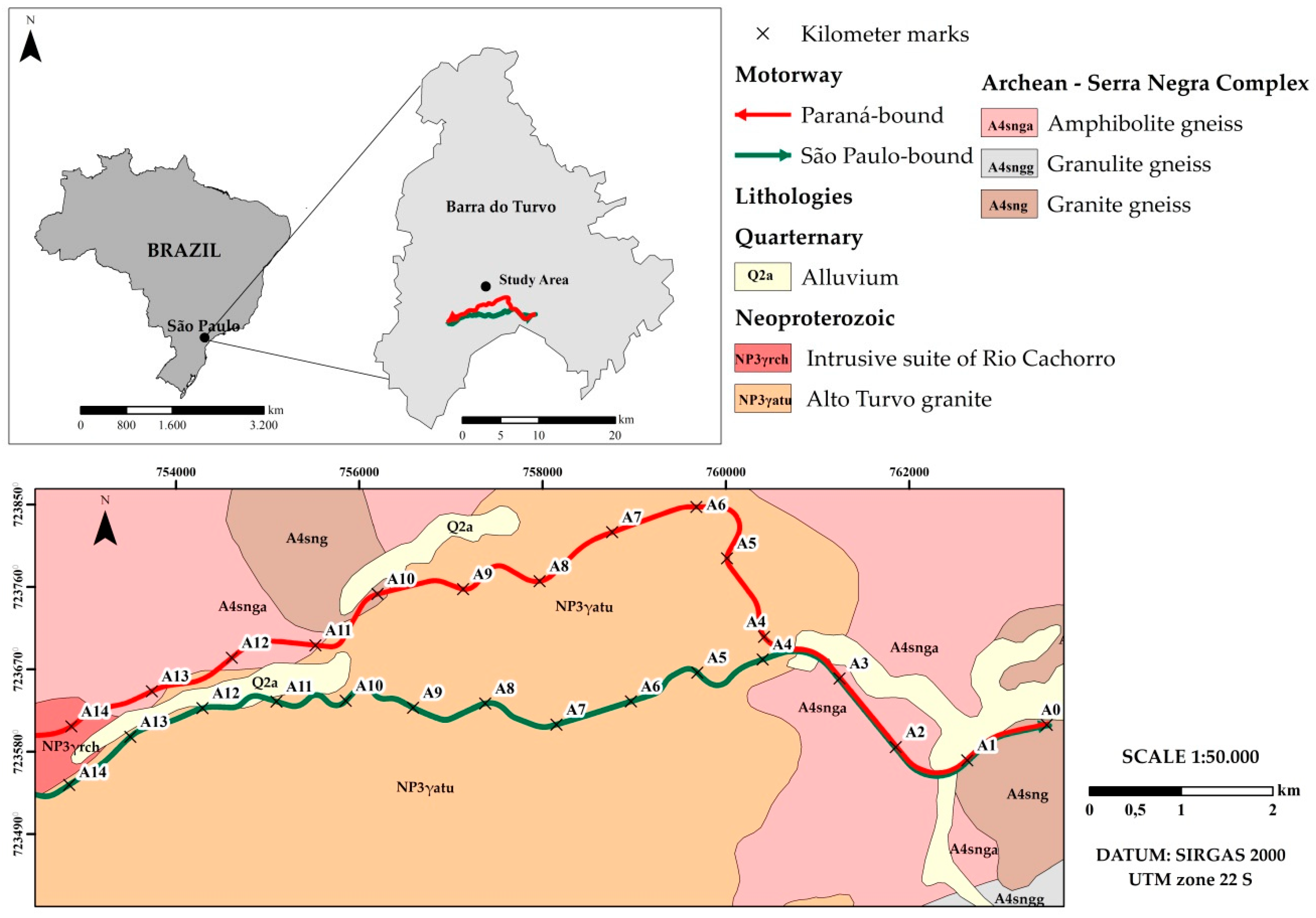
2. Study Area
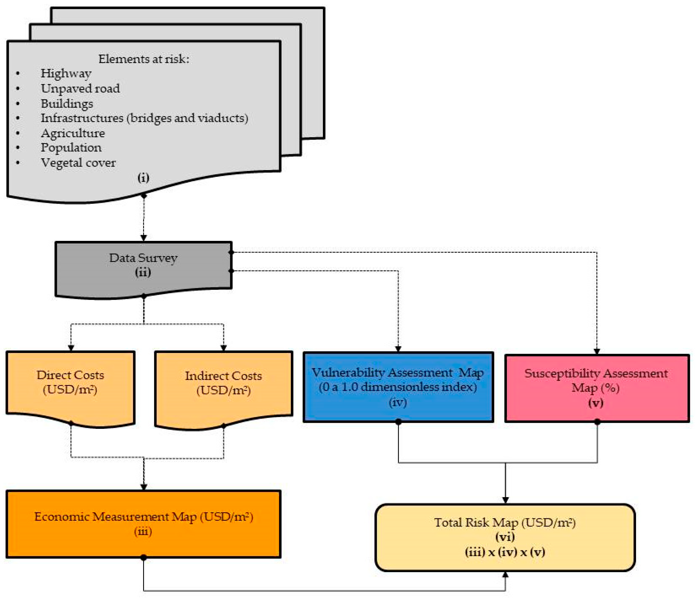
3. Methodologies
3.1. Input Data
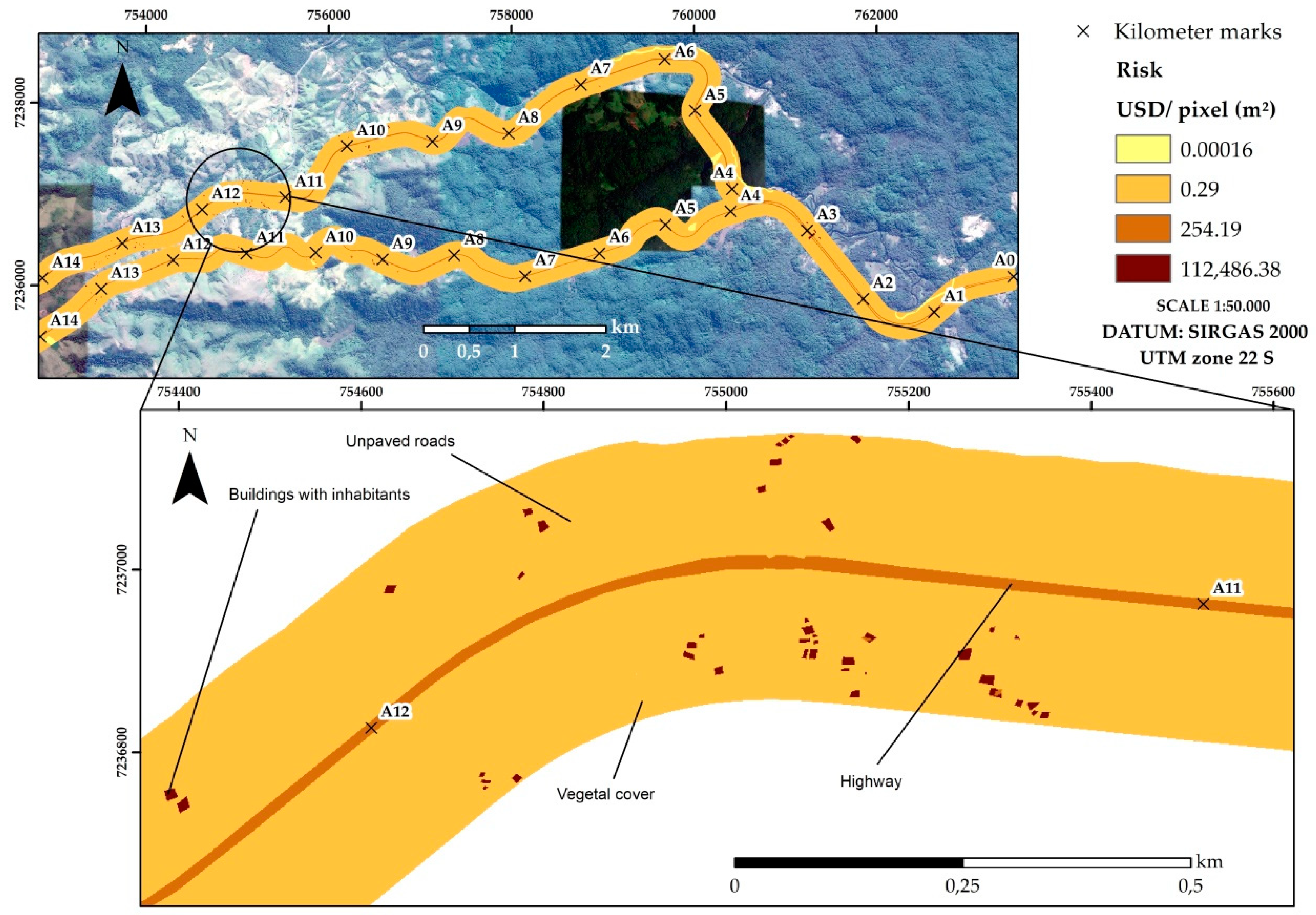
- Land Use Map, designed through aerial images and field visits, with identification of the residences, infrastructures (bridges and viaducts), unpaved roads, agricultural areas, highways, and vegetal cover. One hundred and forty-three buildings were catalogued, and the predominant construction materials were wood and brick, equally. As for the infrastructures, 4 bridges and 3 viaducts were identified, all in reinforced concrete. The agricultural areas are destined to banana plantations. The highway is 7.2 m wide and corresponds to two lanes of 3.6 m, and the mean traffic of 612 vehicles per hour [46];
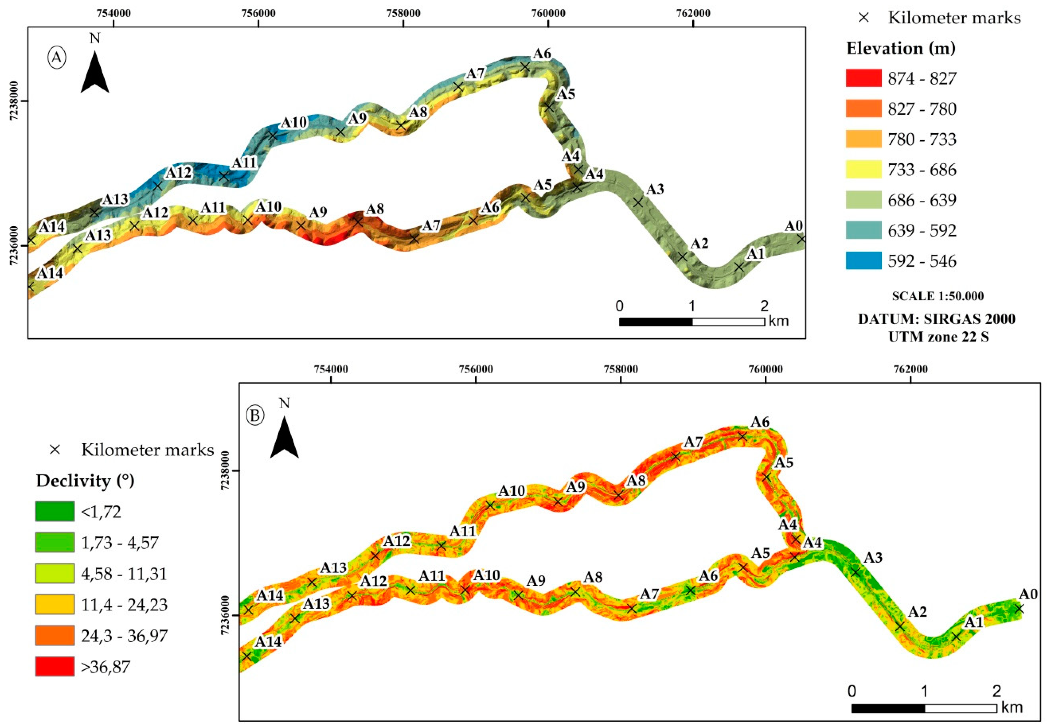
- Digital Elevation Model (DEM) (Figure 3A), elaborated through a topographic map with 1 m equidistant level curves, provided by the Régis Bittencourt Highway Concession Holder. A 150 m domain strip was considered from the highway axle, obtaining the angles, inclination concavities, and elevations;
- Simplified Geotechnical-Geological Map, developed to allow the application of the methodologies in economic risk analysis, through the assessment susceptibility. Mean values of geotechnical parameters of residual and colluvial soils were used. Those parameters were obtained through in situ and lab trials, and correlations between direct (probing) and indirect (geophysics) analysis methods in a slope located in Serra Pelada [48].
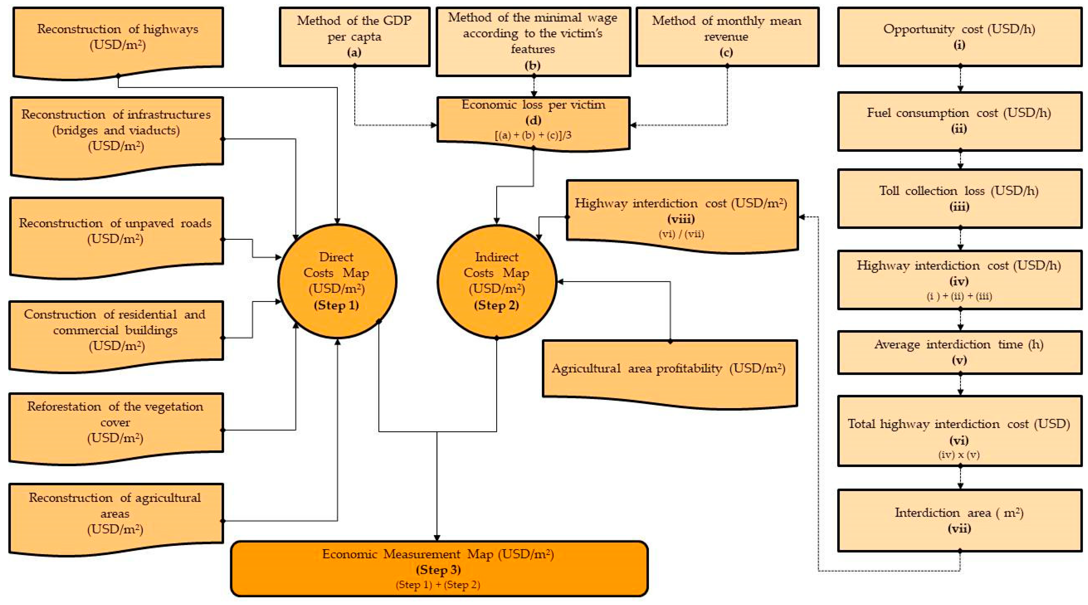
3.2. Economic Measurement
3.2.1. Direct Costs
3.2.2. Indirect Costs
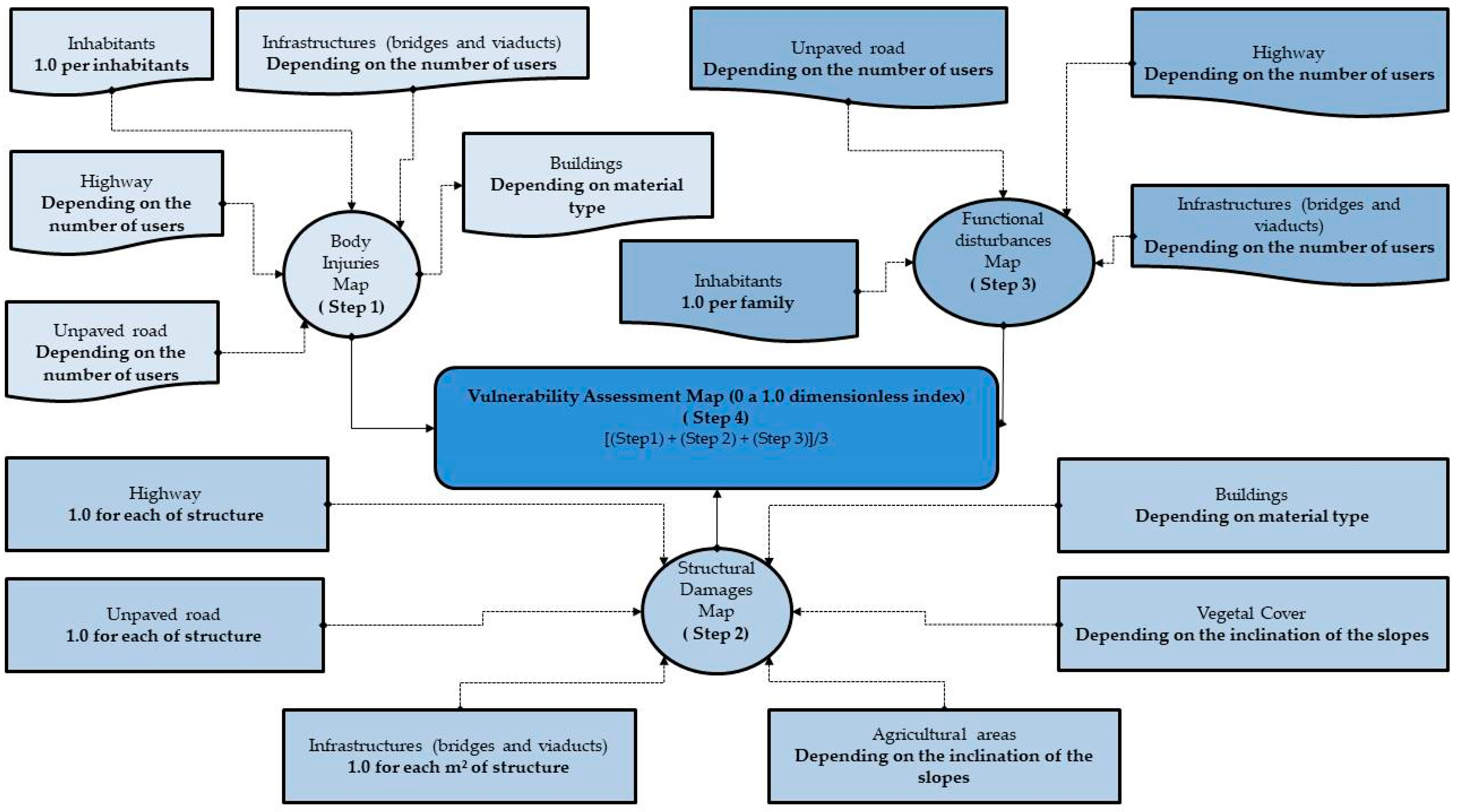
3.3. Vulnerability Analysis
3.4. Susceptibility Analysis
4. Results and Discussion
4.1. Economic Measurement Assessment
4.1.1. Direct Costs
4.1.2. Indirect Costs
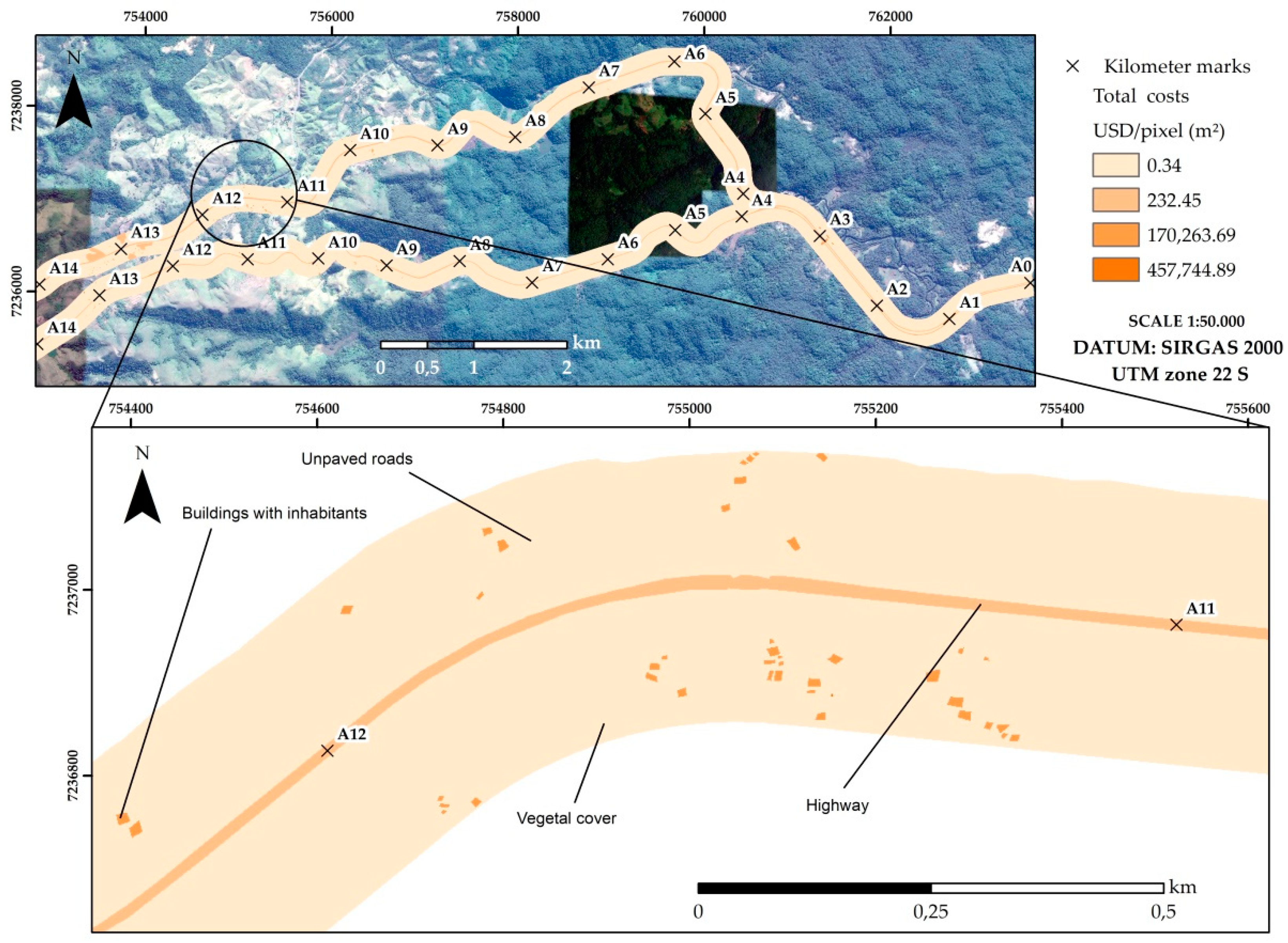
4.1.3. Total Costs
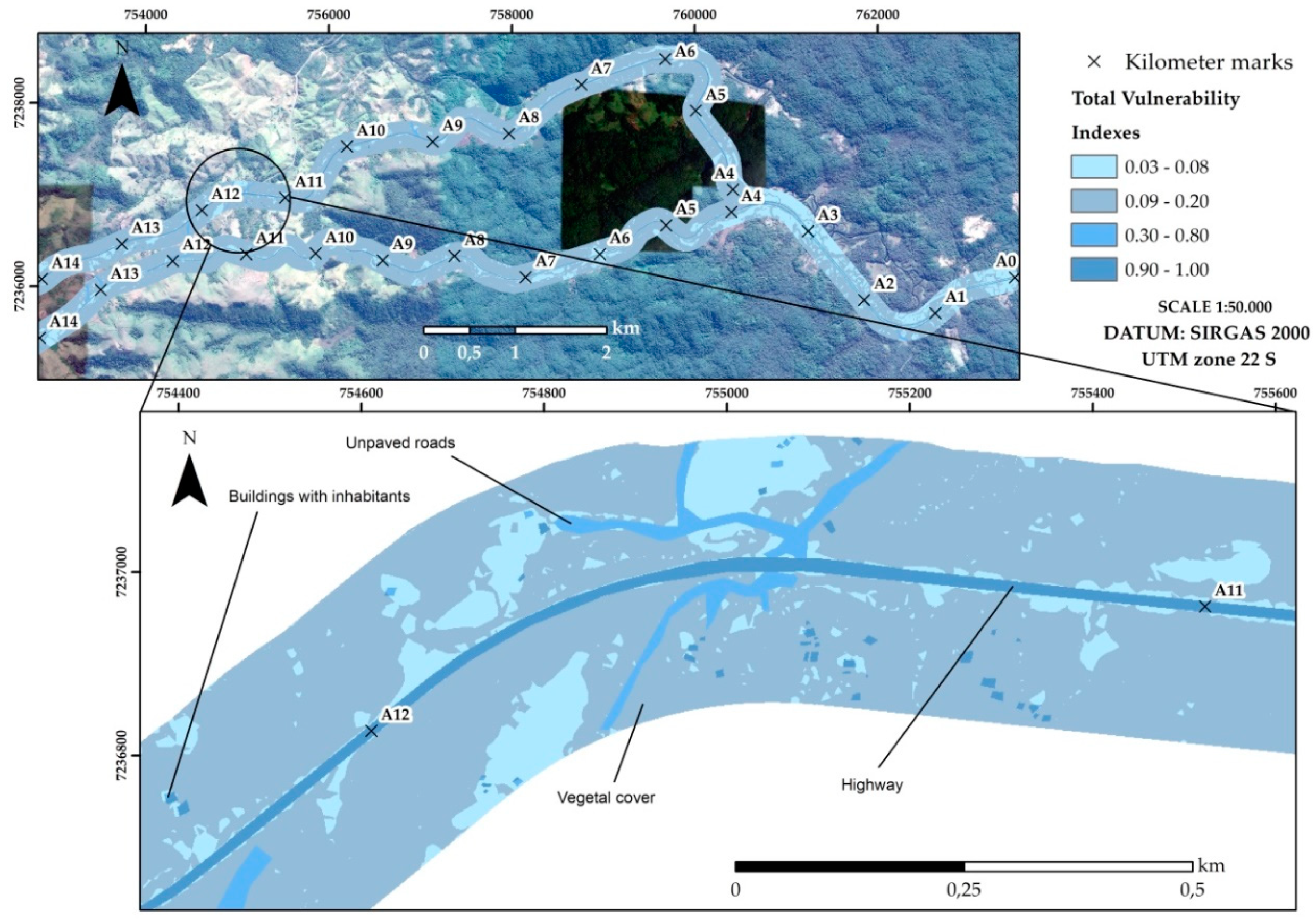
4.2. Vulnerability Assessment
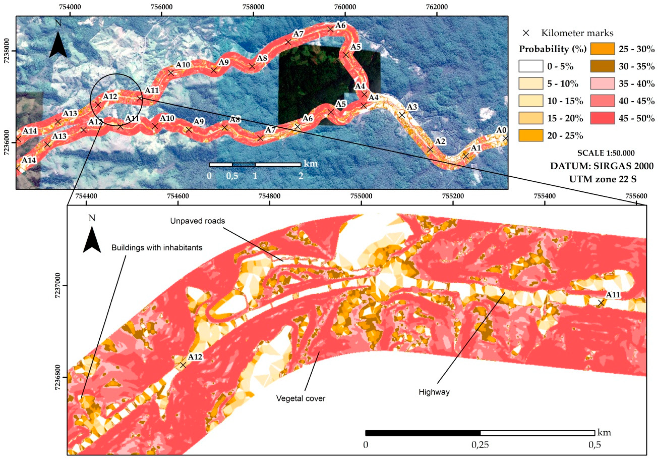
4.3. Susceptibility Assessment
4.4. Risk Assessment
5. Conclusions
Author Contributions
Funding
Acknowledgments
Conflicts of Interest
References
- Brabb, E.E. The world landslide problem. Episodes 1991, 14, 52–61. [Google Scholar] [CrossRef]
- Schuster, R.L.; Highland, L.M. Socioeconomic Impacts of Landslides in the Western Hemisphere; United States Geological Survey: Reston, VA, USA, 2001; pp. 1–47. [CrossRef]
- Fell, R. Landslide risk assessment and acceptable risk. Can. Geotech. J. 1994, 31, 261–272. [Google Scholar] [CrossRef]
- Kim, H.G.; Lee, D.K.; Park, C. Assessing the cost of damage and effect of adaptation to landslides considering climate change. Sustainability 2018, 10, 1628. [Google Scholar] [CrossRef]
- Mousavi, S.M.; Omidvar, B.; Ghazban, F.; Feyzi, R. Quantitative risk analysis for earthquake-induced landslides-Emamzadeh Ali, Iran. Eng. Geol. 2011, 122, 191–203. [Google Scholar] [CrossRef]
- Varnes, D.J.; International Association of Engineering Geology; Commission on Landslides and Other Mass Movements on Slopes. Landslide hazard zonation: A review of principles and practice. In Natural Hazards; United Nations Economic, Scientificand Cultural Organization (UNESCO): Paris, France, 1984; pp. 1–63. ISBN 9231018957. [Google Scholar]
- Crozier, M.J.; Glade, T. Landslide hazard and risk: Issues, concepts and approach. In Landslide Hazard and Risk; Glade, T., Anderson, M., Crozier, M.J., Eds.; John Wiley & Sons Ltd.: Chichester, West Sussex, UK, 2012; pp. 1–40. ISBN 0471486639. [Google Scholar]
- Zêzere, J.L.; Garcia, R.A.C.; Oliveira, S.C.; Reis, E. Probabilistic landslide risk analysis considering direct costs in the area north of Lisbon (Portugal). Geomorphology 2008, 94, 467–495. [Google Scholar] [CrossRef]
- Michael-Leiba, M.; Baynes, F.; Scott, G.; Granger, K. Quantitative landslide risk assessment of Cairns, Australia. In Landslide Hazard and Risk; Glade, T., Anderson, M., Crozier, M.J., Eds.; John Wiley & Sons Ltd.: Chichester, West Sussex, UK, 2012; pp. 621–642. ISBN 0471486639. [Google Scholar]
- Remondo, J.; Bonachea, J.; Cendrero, A. A statistical approach to landslide risk modelling at basin scale: From landslide susceptibility to quantitative risk assessment. Landslides 2005, 2, 321–328. [Google Scholar] [CrossRef]
- Brookshire, D.S.; Chang, S.E.; Cochrane, H.; Olson, R.A.; Rose, A.; Steenson, J. Direct and indirect economic losses from earthquake damage. Earthq. Spectra 1997, 13, 683–701. [Google Scholar] [CrossRef]
- Hallegatte, S. An adaptive regional input-output model and its application to the assessment of the economic cost of Katrina. Risk Anal. 2008, 28, 779–799. [Google Scholar] [CrossRef]
- Spiker, E.C.; Gori, P. Mitigation strategy: A framework for loss reduction. Circular 2003, 1–64. [Google Scholar] [CrossRef]
- Galve, J.P.; Cevasco, A.; Brandolini, P.; Piacentini, D.; Azañón, J.M.; Notti, D.; Soldati, M. Cost-based analysis of mitigation measures for shallow-landslide risk reduction strategies. Eng. Geol. 2016, 213, 142–157. [Google Scholar] [CrossRef]
- Schuster, R.L.; Fleming, R.W. Economic losses and fatalities due to landslides. Environ. Eng. Geosci. 1986, 23, 11–28. [Google Scholar] [CrossRef]
- Guthrie, R. Socio-Economic Significance—Canadian Technical Guidelines and Best Practices Related to Landslides: A National Initiative for Loss Reduction; Natural Resources Canada: Ottawa, ON, Canada, 2013; pp. 1–19. [CrossRef]
- Zêzere, J.L.; Oliveira, S.C.; Garcia, R.A.C.; Reis, E. Landslide risk analysis in the area north of Lisbon (Portugal): Evaluation of direct and indirect costs resulting from a motorway disruption by slope movements. Landslides 2007, 4, 123–136. [Google Scholar] [CrossRef]
- Highland, L.M. Estimating Landslide Losses—Preliminary Results of a Seven-State Pilot Project; United States Geological Survey: Reston, VA, USA, 2006; pp. 1–11. [CrossRef]
- Van Westen, C.J.; Van Asch, T.W.; Soeters, R. Landslide hazard and risk zonation—Why is it still so difficult? Bull. Eng. Geol. Environ. 2006, 65, 167–184. [Google Scholar] [CrossRef]
- Sidle, R.C.; Ochiai, H. Landslides: Processes, prediction, and land use. Water Resour. Monogr. 2006, 18. [Google Scholar] [CrossRef]
- Wong, H.N.; Ko, F.W. Landslide Risk Assessment: Application and Practice; Geotechnical Engineering Office: Homantin, Kowlonn, Hong Kong, 2006; pp. 1–280.
- Remondo, J.; Bonachea, J.; Cendrero, A. Quantitative landslide risk assessment and mapping on the basis of recent occurrences. Geomorphology 2008, 94, 496–507. [Google Scholar] [CrossRef]
- Sunuwar, L.; Karki, M.B.; Shrestha, D. A preliminary landslide risk assessment of road network in mountainous region of Nepal. In Landslide Risk Management; Hungr, O., Fell, R., Couture, R., Eberhardt, E., Eds.; Taylor & Francis Group: London, UK, 2005; pp. 411–422. ISBN 041538043X. [Google Scholar]
- Galve, J.P.; Cevasco, A.; Brandolini, P.; Soldati, M. Assessment of shallow landslide risk mitigation measures based on land use planning through probabilistic modelling. Landslides 2015, 12, 101–114. [Google Scholar] [CrossRef]
- Lari, S.; Frattini, P.; Crosta, G.B. A probabilistic approach for landslide hazard analysis. Eng. Geol. 2014, 182, 3–14. [Google Scholar] [CrossRef]
- Chen, W.; Pourghasemi, H.R.; Kornejady, A.; Xie, X. GIS-based landslide susceptibility evaluation using certainty factor and index of entropy ensembled with alternating decision tree models. In Natural Hazards GIS-Based Spatial Modeling Using Data Mining Techniques; Springer: Berlin/Heidelberg, Germany, 2018; pp. 225–251. [Google Scholar] [CrossRef]
- Kornejady, A.; Ownegh, M.; Bahremand, A. Landslide susceptibility assessment using maximum entropy model with two different data sampling methods. Catena 2017, 152, 144–162. [Google Scholar] [CrossRef]
- De Ploey, J.; Cruz, O. Landslides in the Serra do Mar, Brazil. Catena 1979, 6, 111–122. [Google Scholar] [CrossRef]
- Seluchi, M.E.; Chou, S.C. Synoptic Patterns Associated with Landslide Events in the Serra do Mar, Brazil. Theor. Appl. Climatol. 2009, 98, 67–77. [Google Scholar] [CrossRef]
- Nery, T.D.; Vieira, B.C. Susceptibility to shallow landslides in a drainage basin in the Serra do Mar, São Paulo, Brazil, predicted using the SINMAP mathematical model. Bull. Eng. Geol. Environ. 2015, 74, 369–378. [Google Scholar] [CrossRef]
- Cerri, R.I.; Reis, F.A.G.V.; Gramani, M.F.; Rosolen, V.; Luvizotto, G.L.; do Carmo Giordano, L.; Gabelini, B.M. Assessment of landslide occurrences in Serra do Mar mountain range using kinematic analyses. Environ. Earth Sci. 2018, 77, 1–16. [Google Scholar] [CrossRef]
- Cruz, O. Studies on the geomorphic processes of overland flow and mass movements in the brazilian geomorphology. Rev. Bras. Geociências 2018, 30, 504–507. [Google Scholar] [CrossRef]
- Vieira, B.C.; Fernandes, N.F.; Augusto Filho, O.; Martins, T.D.; Montgomery, D.R. Assessing shallow landslide hazards using the TRIGRS and SHALSTAB models, Serra do Mar, Brazil. Environ. Earth Sci. 2018, 77, 1–15. [Google Scholar] [CrossRef]
- Ichihara, S.M.; Guilhoto, J.J.M. The impact of economic growth on the highways in São Paulo: An application of input-output model combined with GIS. SSRN Electron. J. 2008, 1–35. [Google Scholar] [CrossRef]
- State Planning and Management Secretariat of São Paulo. Integrated regional plan of basic sanitation for UGRHI-11. In Planning Tools’ Strengthening Program of the Sanitation Sector Ribeira de Iguape and South Coast; Sanitation and Power Department: São Paulo, Brazil, 2010; pp. 1–136. (In Portuguese) [Google Scholar]
- CBH-RB—Drainage Basin Committee of Ribeira de Iguape and South Coast. Situation Report of the Hydric Resources of the Managerial Unit No 11: Drainage Basin of Rio Ribeira de Iguape. Available online: http://www.sigrb.com.br/app/pdf/Rel_de_%20Situacao_RB_%202008.pdf (accessed on 29 April 2019). (In Portuguese).
- Lima, A.P.S. Analysis of the Formation Processes of Sítio Capelinha—Establishment of a Microregional Context. Master’s Thesis, The University of São Paulo, São Paulo, Brazil, 2005. (In Portuguese). [Google Scholar] [CrossRef]
- Rodrigues, R. Geological and Geotechnical Characteristics that Affect the Stability of Colluvium Masses of SERRA de Cubatão-SP. Ph.D. Thesis, The University of São Paulo, São Paulo, Brazil, 1992. (In Portuguese). [Google Scholar]
- EMBRAPA. Brazilian System of Soil Classification; National Center of Soil Research: Rio de Janeiro, Brazil, 2006; ISBN 978-85-7035-198-2. (In Portuguese) [Google Scholar]
- Sadowski, G.R. Tectonic of Serra de Cubatão-SP. Ph.D. Thesis, The University of São Paulo, São Paulo, Brazil, 1974. (In Portuguese). [Google Scholar] [CrossRef]
- Lacerda, W.A. Stability of natural slopes along the tropical coast of Brazil. In Proceedings of the Symposium on Recent Developments in Soil and Pavement Mechanics, Rio de Janeiro, Brazil, 25–27 June 1997; pp. 17–39. [Google Scholar]
- Faleiros, F.M.; Morais, S.M.; Costa, V.S. Geology and Mineral Resources of the Apiaí Sheet SG.22-X-B-V; CPRM: São Paulo, Brazil, 2012. Available online: http://rigeo.cprm.gov.br/jspui/handle/doc/11366 (accessed on 29 April 2019). (In Portuguese)
- Riedel, P.S.; Gomes, A.R.; Ferreira, M.V.; Sampaio Lopes, E.S.; Sturaro, J.R. Identification of landslide scars in the region of the Serra do Mar, São Paulo State, Brazil, using digital image processing and spatial analysis tools. GIScience Remote Sens. 2010, 47, 498–513. [Google Scholar] [CrossRef]
- Wong, H.N.; Ho, K.K.S.; Chan, Y.C. Assessment of consequence of landslides. In Landslide Risk Assessment, 1st ed.; Routledge: London, UK, 1997; pp. 111–149. ISBN 9780203749524. [Google Scholar]
- Glade, T. Vulnerability assessment in landslide risk analysis. Die Erde 2003, 134, 123–146. [Google Scholar]
- DNIT—National Department of Transport Infrastructure. PNT—National Research of Traffic. Available online: http://servicos.dnit.gov.br/dadospnct/Pnt/2016 (accessed on 29 April 2019). (In Portuguese)
- ESRI. ArcGIS 10.5; GIS Software; ESRI: New York, NY, USA, 2012. [Google Scholar]
- Trevizolli, M.N.B. Model Proposal for Landslide Risk assessment Based on Pluviometric Event Scenarios: Application on a Slope of Serra do Mar in the PR/SP Section. Master’s Thesis, The Federal University of Paraná, Curitiba, Brazil, 2018. (In Portuguese). [Google Scholar]
- Guide, A. Project Management Body of Knowledge (Pmbok® Guide); Project Management Institute: Newtown Square, PA, USA, 2000; ISBN 1-880410-23-0. [Google Scholar]
- DNIT—National Department of Transport Infrastructure. Average Managerial Costs. Available online: http://www.dnit.gov.br/custos-e-pagamentos/custo-medio-gerencial/ANEXOIXCUSTOMDIOGERENCIALJULHO2017.pdf/view (accessed on 29 April 2019). (In Portuguese)
- EMATER—Paranaense Company of Technical Assistance and Rural Extension. Trafficability Recovery Project of Unpaved Roads. Available online: http://www.agricultura.pr.gov.br/arquivos/File/nuconv/Aditivos/Convenio_435_California_diesel/CALIFORNIA_TA_CV435_2013_RVI.pdf (accessed on 29 April 2019). (In Portuguese)
- CBIC—Brazilian Chamber of the Construction Industry. Brazil Mean CUB. Available online: http://www.cbicdados.com.br/media/anexos/7.1_Sala_de_Imprensa_75.pdf (accessed on 29 April 2019). (In Portuguese).
- Cui, P.; Lin, Y.M.; Chen, C. Destruction of vegetation due to geo-hazards and its environmental impacts in the Wenchuan earthquake areas. Ecol. Eng. 2012, 44, 61–69. [Google Scholar] [CrossRef]
- Corrêa, R.S.; Ferreira, G. Recovery of Areas Degraded by Mining on the Cerrado—Guidebook for Revegetation; Universa: Brasília, Brazil, 2009. (In Portuguese) [Google Scholar]
- Vieira, T.P. Estimation of the Necessary Investment for the Recomposition of the Forest Cover at the APPS of the Basin of Ribeirão Itaim in Taubaté—SP. Master’s Thesis, The University of Taubaté, Taubaté, Brazil, 2008. (In Portuguese). [Google Scholar]
- MAPA—Ministry of Agriculture, Farming, and Supply. Available online: https://www.defesa.agricultura.sp.gov.br/noticias/2018/ministerio-da-agricultura-aprova-smr-para-a-sigatoka-negra-no-vale-do-ribeira,1218.html (accessed on 29 April 2019). (In Portuguese)
- Cardoso, C.E.L. Production cost of Musa x Paradisiaca, L. Musaceae. Available online: https://www.agencia.cnptia.embrapa.br/Agencia40/AG01/arvore/AG01_21_41020068055.html (accessed on 29 April 2019). (In Portuguese).
- Miller, T.R. Variations between countries in values of statistical life. J. Transp. Econ. Policy 2000, 34, 169–188. [Google Scholar]
- Porter, K.A.; Asce, M. Life safety risk criteria in seismic decisions. In Acceptable Risk to Lifeline Systems form Natural Hazard Threats; Taylor, C.E., VanMarke, E., Eds.; Technical Council for Lifeline Earthquake Engineering, American Society of Civil Engineers: Reston, VA, USA, 2001; pp. 1–24. Available online: https://pdfs.semanticscholar.org/a26c/5b7161a9b1d542e25bbe581b94e6616834ea.pdf (accessed on 29 April 2019).
- Carvalho, J.L. Quantification of Product Loss with Traffic Accidents: Preliminary Methodology and Evidences; Funenseg: Rio de Janeiro, Brazil, 2015; ISBN 978-85-7052-577-2. (In Portuguese) [Google Scholar]
- IBGE—Brazilian Institute of Geography and Statistics. PNADC/T—National Research by Quarterly Domicile Sampling. Available online: https://sidra.ibge.gov.br/pesquisa/pnadct/tabelas (accessed on 29 April 2019). (In Portuguese)
- McMahon, K.; Dahdah, S. The True Cost of Road Crashes: Valuing Life and Cost of a Serious Injury; International Road Assessment Programme: Hampshire, UK, 2010. [Google Scholar]
- IBGE—Brazilian Institute of Geography and Statistics. CEMPRE—Statistics of the Company Central Registration. Available online: https://www.ibge.gov.br/estatisticas/economicas/outras-estatisticas-economicas/9016-estatisticas-do-cadastro-central-de-empresas.html?edicao=15403&t=sobre (accessed on 29 April 2019). (In Portuguese)
- IBGE—Brazilian Institute of Geography and Statistics. Complete Mortality Chart for Brazil—2016. In Brief Analysis of Mortality Evolution in Brazil; IBGE: Rio de Janeiro, Brazil, 2017. [Google Scholar]
- Jayasooriya, S.A.C.S.; Bandara, Y.M.M.S. Measuring the economic costs of traffic congestion. In Proceedings of the 3rd International Moratuwa Engineering Research Conference, Moratuwa, Sri Lanka, 29–31 May 2017. [Google Scholar] [CrossRef]
- DNIT—National Department of Transport Infrastructure. Guidebook of Traffic Studies. Publication IPR–723. Available online: http://www1.dnit.gov.br/arquivos_internet/ipr/ipr_new/manuais/manual_estudos_trafego.pdf (accessed on 29 April 2019). (In Portuguese)
- Winfrey, R. Economic Analysis for Highways; International Textbook Co.: Scranton, PA, USA, 1969; pp. 1–923. ISBN 978-0700222445. [Google Scholar]
- ANP—National Agency of Oil. Price Consultation System. Available online: https://preco.anp.gov.br/ (accessed on 29 April 2019). (In Portuguese)
- Régis Bittencourt Highway, S.A. Annual Complete Financial Statements 2018. Available online: http://ri.arteris.com.br/ptb/7319/667946.pdf (accessed on 29 April 2019). (In Portuguese).
- Van Der Knaap, W.G.M. The vector to raster conversion: (mis)use in geographical information systems. Int. J. Geogr. Inf. Syst. 1992, 6, 159–170. [Google Scholar] [CrossRef]
- Arnone, E.; Francipane, A.; Scarbaci, A.; Puglisi, C.; Noto, L.V. Effect of raster resolution and polygon-conversion algorithm on landslide susceptibility mapping. Environ. Model. Softw. 2016, 84, 467–481. [Google Scholar] [CrossRef]
- Guillard-Gonçalves, C. Vulnerability Assessment and Landslide Risk Analysis: Application to the Loures Municipality, Portugal. Ph.D. Thesis, Universidade de Lisboa, Lisboa, Portugal, 2016. [Google Scholar] [CrossRef]
- Leone, F. Characterization of “Natural” Catastrophic Vulnerabilities: Contribution to a Multirisk Geographic Assessment (Land Movements, Earthquakes, Tsunamis, Volcanic Eruptions, Cyclones). Geography; Paul Valéry University: Montpellier, France, 2007. (In French) [Google Scholar]
- Uzielli, M.; Lacasse, S. Scenario-based probabilistic estimation of direct loss for geohazards. Georisk Assess. Manag. Risk Eng. Syst. Geohazards 2007, 1, 142–154. [Google Scholar] [CrossRef]
- IBGE—Brazilian Institute of Geography and Statistics. Demographic Census 2010: Characteristics of the Population and Domiciles: Results of the Universe; IBGE: Rio de Janeiro, Brazil, 2011. (In Portuguese)
- Finlay, P.J.; Fell, R. Landslides: Risk perception and acceptance. Can. Geotech. J. 1997, 34, 169–188. [Google Scholar] [CrossRef]
- Leone, F.; Asté, J.-P.; Leroi, E. Vulnerability assessment of elements exposed to mass-movement: Working toward a better risk perception. Landslides-Glissements de Terrain Balkema Rotterdam 1996, 1, 263–270. [Google Scholar]
- Silva, M.; Pereira, S. Assessment of physical vulnerability and potential losses of buildings due to shallow slides. Nat. Hazards 2014, 72, 1029–1050. [Google Scholar] [CrossRef]
- Ortigão, J.A.R.; Sayão, A. Handbook of Slope Stabilisation; Springer: Berlin/Heidelberg, Germany, 2004. [Google Scholar]
- Römer, W. Accordant summit heights, summit levels and the origin of the “upper denudation level” in the Serra do Mar (SE-Brazil, São Paulo): A study of hillslope forms and processes. Geomorphology 2008, 100, 312–327. [Google Scholar] [CrossRef]
- Tabalipa, N. Geoenvironmental Mapping of the City of Pato Branco, Paraná, as Tool for Territorial and Environmental Planning. Ph.D. Thesis, University of Paraná, Curitiba, Brazil, 2008. [Google Scholar]
- Fiori, A.P. Stability study of slopes in the area of Guaraqueçaba, Paraná. Bol. Paraná. Geociências 1995, 43, 25–40. (In Portuguese) [Google Scholar]
- Nunes, F.G. Investigation of risk areas based on the geoenvironmental dynamics of the slopes of Serra do Mar, in Paraná. Bol. Paraná. Geociências 2013, 52, 97–114. [Google Scholar] [CrossRef]
- Carmignani, L.; Fiori, A. Basics of Soil and Rock Mechanics; Oficina de Textos: São Paulo, Brazil, 2015; ISBN 9788579751844. (In Portuguese) [Google Scholar]
- Wolle, C.M.; Pedrosa, J.A.B. Transition horizons condition slope stabilization mechanisms in Serra do Mar. In Brazilian Convention of Engineering Geology; Brazilian Association of Engineering and Environmental Geology: Itapema, Brazil, 1981; pp. 121–135. (In Portuguese) [Google Scholar]
- Acevedo, A.M.G. Geological-Geotechnical Simulation to Evaluate Slope Stability Based on Geoprocessing Techniques. Ph.D. Thesis, University of Paraná, Curitiba, Brazil, 2017. (In Portuguese). [Google Scholar]
- Coy, Y.S.M. Susceptibility Assessment of the Slopes of a Section of BR-376, between km 658+820 m and 660+690 m, PR. Master’s Thesis, University of Paraná, Curitiba, Brazil, 2015. (In Portuguese). [Google Scholar]
- Spiegel, M.R. Statistics: Summary of the Theory 875 Problems Solved 619 Problems Proposed; Mc Graw-Hill do Brasil: São Paulo, Brazil, 1977. (In Portuguese) [Google Scholar]
- Trindade, A.V.; Borges, A.L.; Teixeira, A.H.C.; Matos, A.P.; Ritzinger, C.H.S.P.; Almeida, C.O.; Costa, D.C.; Costa, E.L.; Alves, E.J.; Coelho, E.F.; et al. Banana Tree Cultivation; Borges, A.L., Souza, L.S., Eds.; Embrapa Mandioca e Fruticultura: Cruz das Almas, Brazil, 2004; pp. 1–279. ISBN 85-7158-010-3. (In Portuguese) [Google Scholar]
- Rose, A.; Porter, K.; Dash, N.; Bouabid, J.; Huyck, C.; Whitehead, J.; Shaw, D.; Eguchi, R.; Taylor, C.; McLane, T.; et al. Benefit-cost analysis of FEMA hazard mitigation grants. Nat. Hazards Rev. 2007, 8, 97–111. [Google Scholar] [CrossRef]
- Mundial, B. Assessment of Losses and Damages—Floods and Landslides at the Mountain Range Region of Rio de Janeiro. Report Drafted by the World Bank with the Support of the State Government of Rio de Janeiro. Brasília. 2012. Available online: http://documents.worldbank.org/curated/en/260891468222895493/pdf/NonAsciiFileName0.pdf (accessed on 29 April 2019). (In Portuguese).
- Bonachea Pico, J. Development, Application and Validation of Procedures and Models for the Assessment of Threats, Vulnerability and Risk Due to Geomorphological Processes. Ph.D. Thesis, University of Cantabria, Santander, Spain, 2006. (In Spanish). [Google Scholar]
- Rosa, T.C.D.S.; Sathler, M.; Costa, M.; Mendonça, M.B.D.; Reginensi, C.; Souza, R.M.D. Risk associated with mass movement in the Boa Vista Hill (Vila Velha/Espírito Santo): From territory characterization to the need for public policies. Cad. Metrópole 2018, 20, 399–421. (In Portuguese) [Google Scholar] [CrossRef]
- Vieira, B.C.; Fernandes, N.F.; Filho, O.A. Shallow landslide prediction in the Serra do Mar, São Paulo, Brazil. Nat. Hazards Earth Syst. Sci. 2010, 10, 1829–1837. [Google Scholar] [CrossRef]
- Vranken, L.; Van Turnhout, P.; Van Den Eeckhaut, M.; Vandekerckhove, L.; Poesen, J. Economic valuation of landslide damage in hilly regions: A case study from Flanders, Belgium. Sci. Total Environ. 2013, 447, 323–336. [Google Scholar] [CrossRef] [PubMed]
- Mora, S.; Keipi, K. Disaster risk management in development projects: Models and checklists. Bull. Eng. Geol. Environ. 2006, 65, 155–165. [Google Scholar] [CrossRef]
| Elements | Typology | Indexes |
|---|---|---|
| Building | Brick masonry | 0.50 |
| Wooden | 1.00 | |
| Roads | Highway | 1.00 |
| Unpaved road | 0.01 | |
| Slope Relief classification | 0–3% | 0.17 |
| 3–8% | 0.34 | |
| 8–20% | 0.51 | |
| 20–45% | 0.68 | |
| 45–75% | 0.85 | |
| >75% | 1.00 |
| Composition of the Costs of Interdiction (USD/h) | Duration of Interdiction (h) | Cost of Interdiction by Landslide (USD) | Total Highway Area (m2) | Cost of Interdiction (USD/m2) | |
|---|---|---|---|---|---|
| Opportunity cost | 11,718.37 | 8 | 209,795.50 | 268,392.48 | 0.78 |
| Cost with fuel consumption | 2618.59 | ||||
| Loss of toll collection | 11,887.44 | ||||
| Elements Exposed | Direct Costs (USD) | Indirect Costs (USD) |
|---|---|---|
| Highway | 31,895,716.85 | - |
| Infrastructures | 5,785,168.14 | - |
| Buildings | 4,522,820.29 | - |
| Vegetal cover | 3,633,858.58 | - |
| Banana plantation | 67,508.01 | 18,307.28 |
| Unpaved road | 14,131.57 | - |
| Victims | - | 306,054,263.09 |
| Highway interdiction | - | 53,852.16 |
© 2019 by the authors. Licensee MDPI, Basel, Switzerland. This article is an open access article distributed under the terms and conditions of the Creative Commons Attribution (CC BY) license (http://creativecommons.org/licenses/by/4.0/).
Share and Cite
Felizardo Batista, E.; De Brum Passini, L.; Christopher Morales Kormann, A. Methodologies of Economic Measurement and Vulnerability Assessment for Application in Landslide Risk Analysis in a Highway Domain Strip: A Case Study in the Serra Pelada Region (Brazil). Sustainability 2019, 11, 6130. https://doi.org/10.3390/su11216130
Felizardo Batista E, De Brum Passini L, Christopher Morales Kormann A. Methodologies of Economic Measurement and Vulnerability Assessment for Application in Landslide Risk Analysis in a Highway Domain Strip: A Case Study in the Serra Pelada Region (Brazil). Sustainability. 2019; 11(21):6130. https://doi.org/10.3390/su11216130
Chicago/Turabian StyleFelizardo Batista, Ellen, Larissa De Brum Passini, and Alessander Christopher Morales Kormann. 2019. "Methodologies of Economic Measurement and Vulnerability Assessment for Application in Landslide Risk Analysis in a Highway Domain Strip: A Case Study in the Serra Pelada Region (Brazil)" Sustainability 11, no. 21: 6130. https://doi.org/10.3390/su11216130
APA StyleFelizardo Batista, E., De Brum Passini, L., & Christopher Morales Kormann, A. (2019). Methodologies of Economic Measurement and Vulnerability Assessment for Application in Landslide Risk Analysis in a Highway Domain Strip: A Case Study in the Serra Pelada Region (Brazil). Sustainability, 11(21), 6130. https://doi.org/10.3390/su11216130


