Dynamic of Regional Planning and Sustainable Development in the Pearl River Delta, China


Abstract
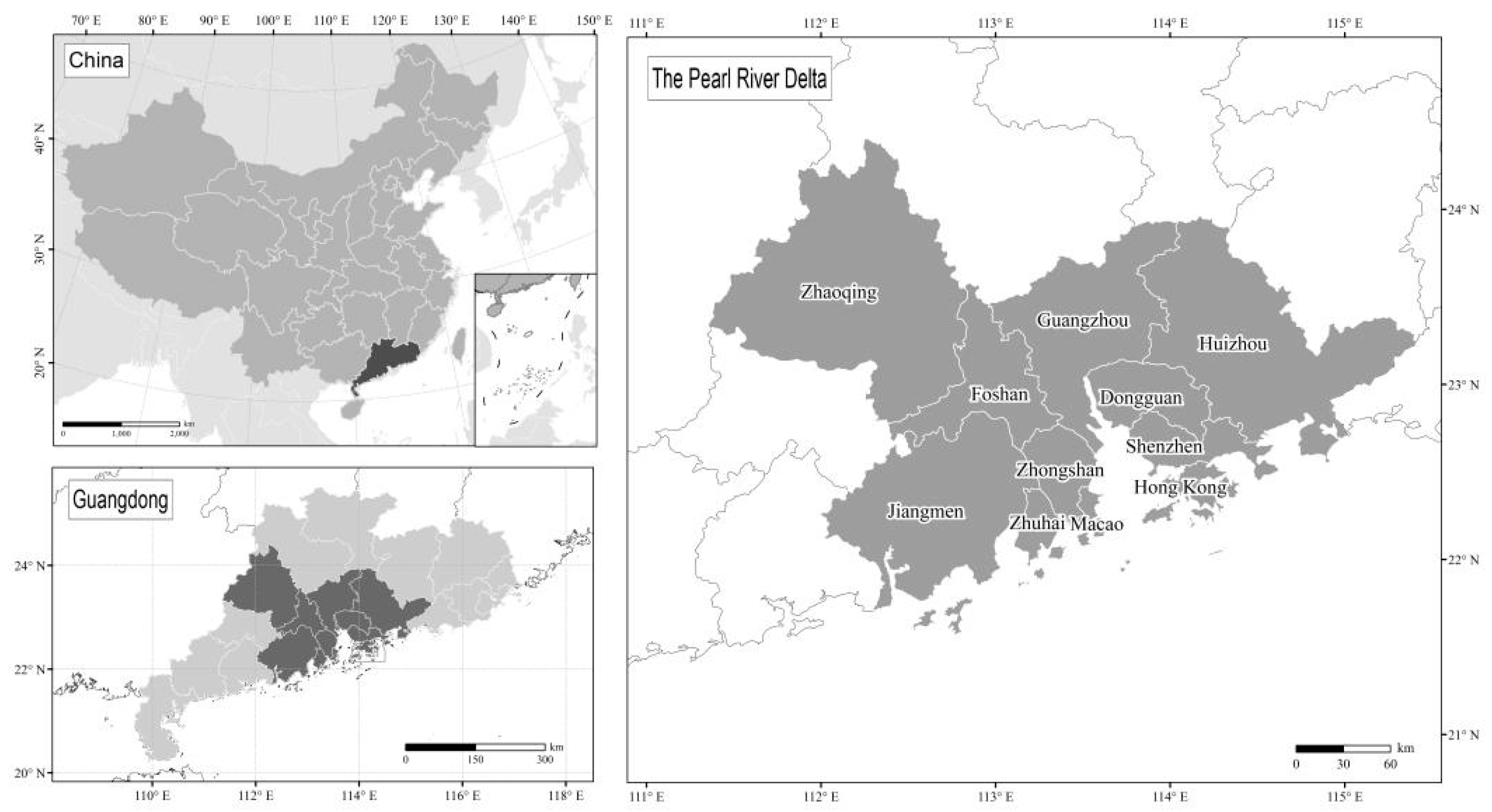
1. Introduction
2. Data and Methodology
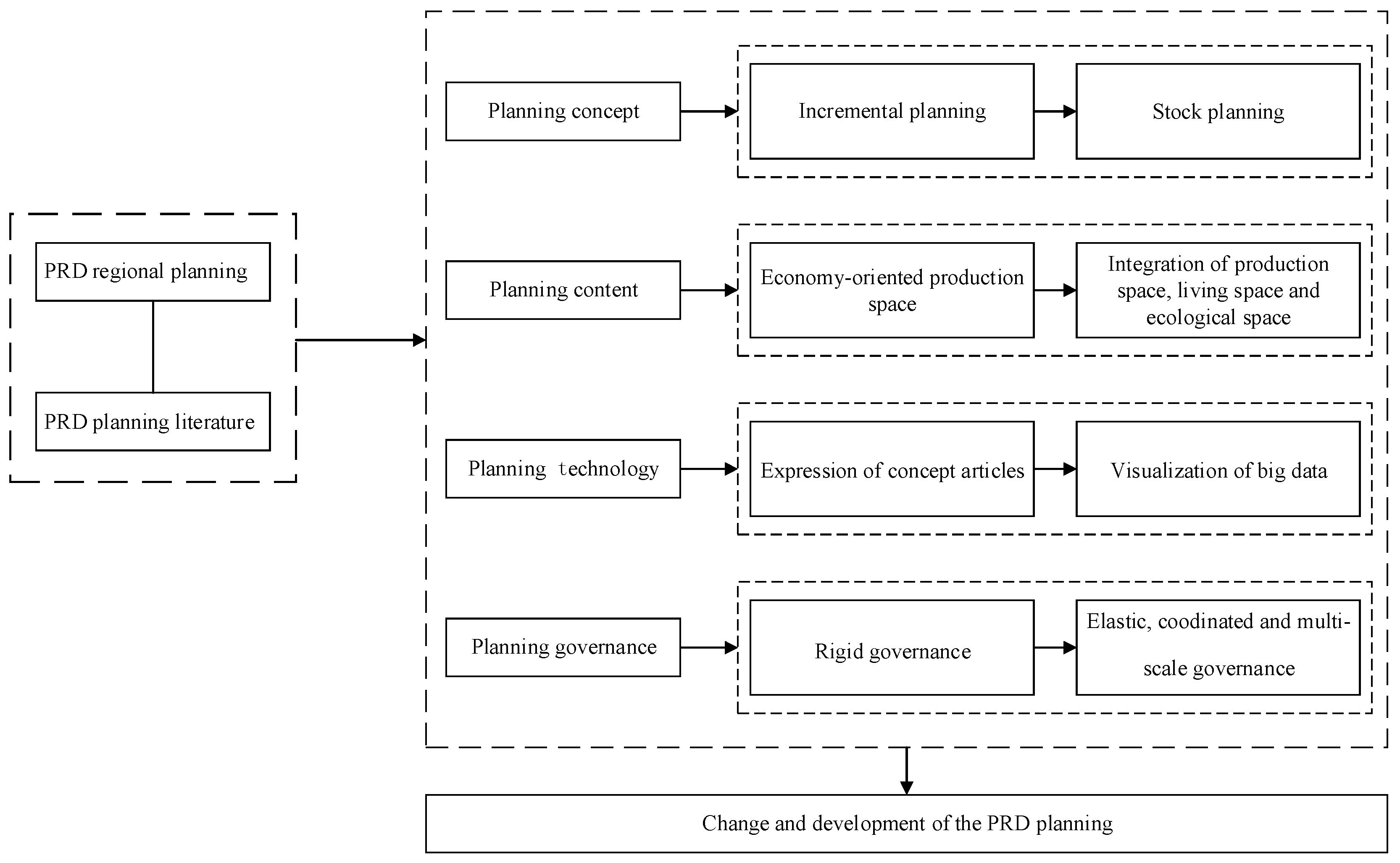
3. Evaluation of Regional Plannings in Pearl River Delta
3.1. Change of Planning Concept
3.2. Transformation of Planning Content
3.2.1. Production Space
3.2.2. Living Space
3.2.3. Ecological Space
3.3. Upgrading of Planning Technological Means
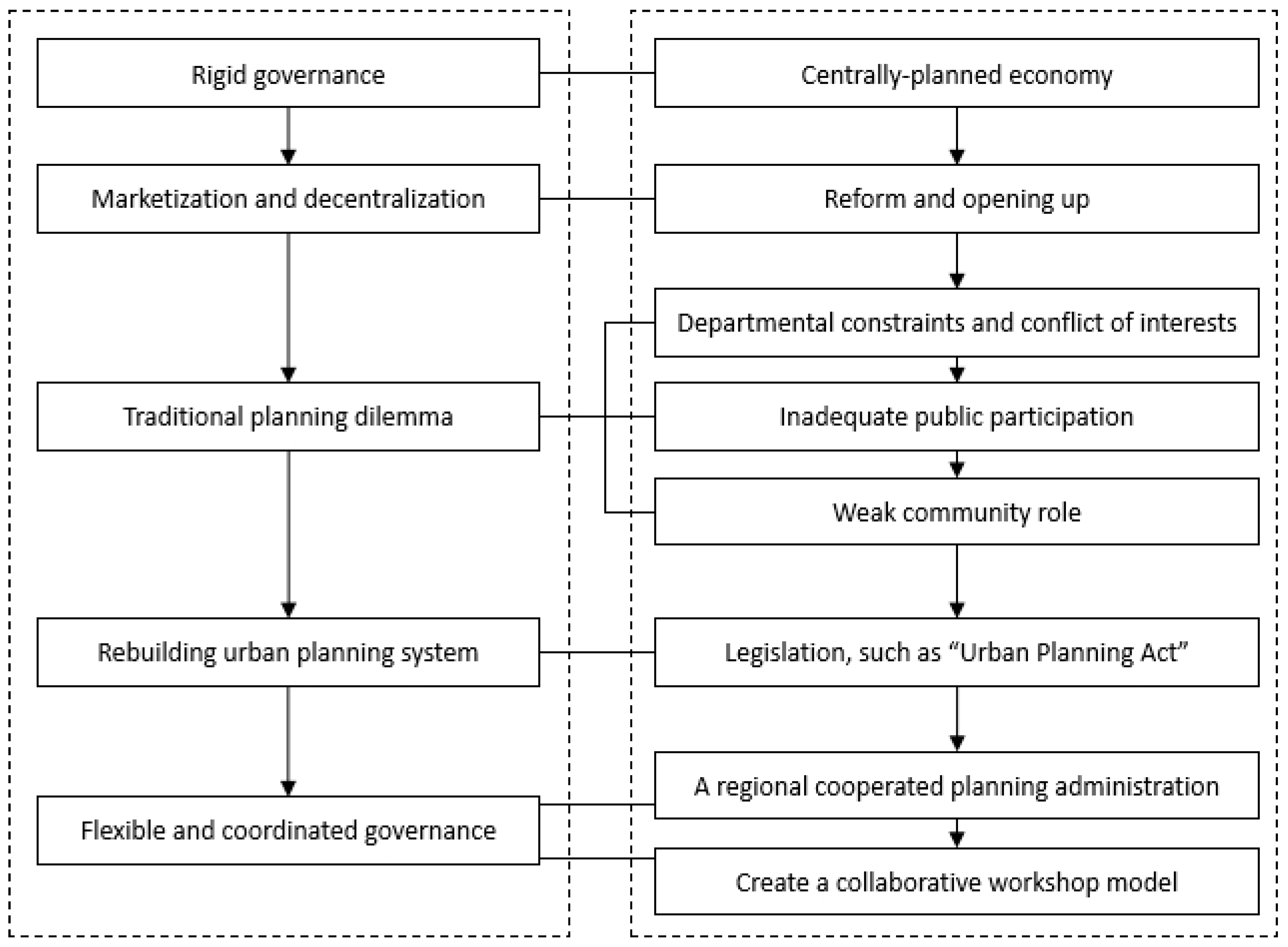
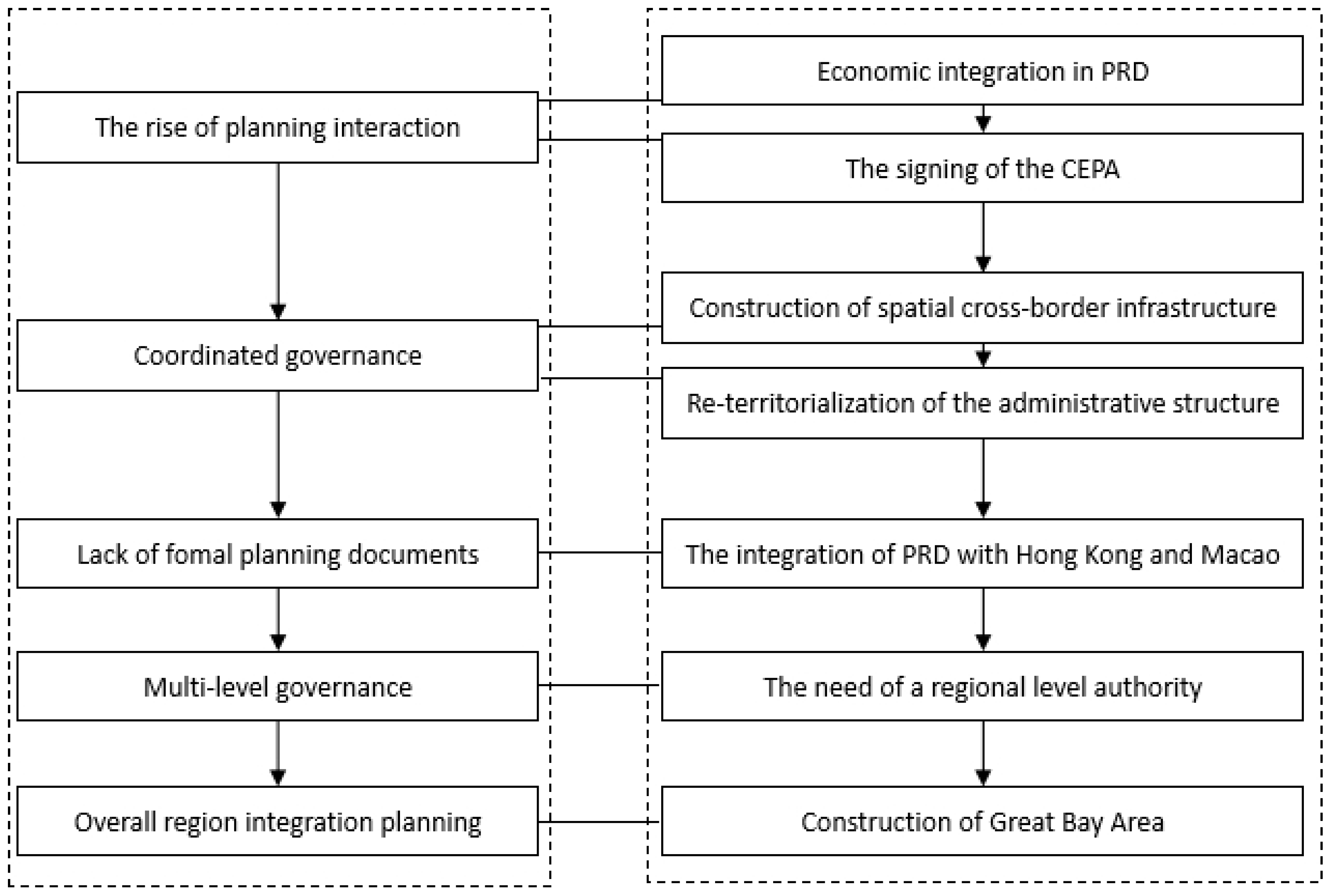
3.4. Promotion of Governance Measures
4. Conclusions and Discussion
Author Contributions
Funding
Acknowledgments
Conflicts of Interest
References
- Du, Z.W.; Li, X. Growth or shrinkage: New phenomena of regional development in the rapidly-urbanising Pearl River Delta. Acta Geogr. Sin. 2017, 72, 1800–1811. [Google Scholar]
- Xu, J. Governing city-regions in China: Theoretical issues and perspectives for regional strategic planning. Town Plan. Rev. 2008, 79, 157–185. [Google Scholar] [CrossRef]
- Yang, J.; Zhu, S. Effect of industrial transfer policy on the evolution of regional product structure: Based on the “Double Transfer” policy in Guangdong Province. Trop. Geogr. 2017, 37, 452–461. [Google Scholar]
- Chen, X.M.; Taylor, L.O. China’s emerging Silicon Valley: How and why has Shenzhen become a global innovation centre. Eur. Financ. Rev. 2017, 1, 55–62. [Google Scholar]
- Wei, Y.H.D. Regional inequality in China. Prog. Hum. Geogr. 1999, 23, 49–59. [Google Scholar] [CrossRef]
- Jia, L. Analysis on turning to public policy of Pearl River Delta urban agglomeration planning. Mod. Urb. Res. 2016, 1, 78–82. [Google Scholar]
- Yang, R. An analysis of rural settlement patterns and their effect mechanisms based on road traffic accessibility of Guangdong. Acta Geogr. Sin. 2017, 72, 1859–1871. [Google Scholar]
- Zhang, X.L.; Lin, Y.L.; Wu, Y.Z.; Skitmore, M. Industrial land price between China’s Pearl River Delta and Southeast Asian regions: Competition or Coopetition? Land Policy 2017, 61, 575–586. [Google Scholar] [CrossRef]
- Chung, C.K.L.; Zhang, F.; Wu, F. Negotiating Green Space with Landed Interests: The Urban Political Ecology of Greenway in the Pearl River Delta, China. Antipode 2018, 1, 1–19. [Google Scholar] [CrossRef]
- Chen, B. Rail transit development of the Pearl River Delta planning, obstacles and history. Urb. Rail Transit 2018, 4, 13–22. [Google Scholar] [CrossRef]
- Lai, S.H.; Yan, Y.T.; Liu, G.N.; Pang, X.M.; Li, Y.Z. A review, evaluation and reflection of the Pearl River Delta regional plan. Urb. Plan. Forum 2015, 4, 12–19. [Google Scholar]
- Fan, D.L.; Lu, X.B. Spatial evolution and planning response under “One Belt, One Road” impact. Planners 2016, 32, 17–22. [Google Scholar]
- Xu, X.Q.; Li, X. Research on the urbanization of Pearl River Delta (1978–2008): Review and preview. Hum. Geogr. 2009, 24, 1–6. [Google Scholar]
- Wu, F. Planning for Growth; Routledge: Abingdon, UK, 2015; pp. 25–118. (In Chinese) [Google Scholar]
- Yeh, A.G.O.; Li, X. Urban growth management in the Pearl river delta: An integrated remote sensing and GIS approach. ITC J. 1996, 1, 77–85. [Google Scholar]
- Su, J.; Wei, Q.; Guo, H. The mechanism and adjustment of urban sprawl of Guangzhou. Acta Geogr. Sin. 2005, 60, 626–636. [Google Scholar]
- Roberts, P.; Chan, R.C.K. A tale of two regions: Strategic planning for sustainable development in East and West. Int. Plan. Stud. 1997, 2, 45–62. [Google Scholar] [CrossRef]
- Peng, J.; Wang, Y.L.; Jing, J.; Song, Z.Q.; Han, D. Research on integrated regional planning of urban landscape functions: A case study in Shenzhen City. Acta Ecol. Sin. 2005, 25, 1714–1719. [Google Scholar]
- Liu, Y.; Liang, Y.T.; Ma, S.P.; Huang, K.X. Divergent developmental trajectories and strategic coupling in the Pearl River Delta: Where is a sustainable way of regional economic growth? Sustainability 2017, 9, 1782. [Google Scholar] [CrossRef]
- Zeng, C.; Zhang, A.L.; Liu, L.; Liu, Y. Administrative restructuring and land-use intensity—A spatial explicit perspective. Land Policy 2017, 67, 190–199. [Google Scholar] [CrossRef]
- Du, J.F.; Thill, J.C.; Peiser, R.B. Land pricing and its impact on land use efficiency in post-land-reform China: A case study of Beijing. Cities 2016, 50, 68–74. [Google Scholar] [CrossRef]
- Zou, B. Increment planning, inventory planning and policy planning. City Plan. Rev. 2013, 2, 35–37. [Google Scholar]
- Zou, B. The transformation from greenfield-based planning to redevelopment planning: Theoretical analysis and practical strategies. Urb. Plan. Forum 2015, 5, 12–19. [Google Scholar]
- Xu, J.; Yeh, A.G.O. City profile. Cities 2003, 20, 361–374. [Google Scholar] [CrossRef]
- Shi, W.L.; Zou, B.; Jin, Z.M.; Shi, X.D.; Ding, C.R.; Wang, K.; Zhao, Y.J.; Zhen, H.; Lin, J.; Shi, N. Master plan targeted stock and decrement. City Plan. Rev. 2014, 38, 16–21. [Google Scholar]
- Zhou, Y.; Long, Y. Urban development analysis and simulation to address inventory and increment planning: A case study of Chengdu. Geogr. Geo-Inf. Sci. 2016, 32, 45–51. [Google Scholar]
- Gu, C.; Hu, L.; Guo, J.; Cook, I.G. China’s urban planning in transition. Proceedings of the Institution of Civil Engineers. Urb. Des. Plan. 2014, 167, 221–236. [Google Scholar] [CrossRef]
- Chao, H. Development model of city-industry integration in Pearl River Delta Desakota: Case of Foahan city. Urb. Rural Dev. 2018, 12, 51–54. [Google Scholar]
- Sit, V.F.S.; Yang, C. Foreign-investment-induced Exo-urbanisation in the Pearl River Delta, China. Urb. Stud. 1997, 34, 647–677. [Google Scholar] [CrossRef]
- Zhu, X.H. A study on spatial governance strategy of desakota area in Pearl River Delta region. Urb. Plan. Forum 2015, 2, 77–82. [Google Scholar]
- Tan, Y.W.; Wang, L.; Xiong, L.F. Spatial planning and governance of Desakota Area in Pearl River Delta. Planners 2018, 34, 126–131. [Google Scholar]
- Li, W.B.; Chen, H. Analysis of city-industry integration and planning strategies. Urb. Plan. Forum 2012, 7, 99–103. [Google Scholar]
- Liu, Y.Y.; Han, W.C.; Yan, Y.T.; Li, Y.Z. Capital, power and production of space: The development paths and prospects of strategic areas in the Pearl River Delta. Urb. Plan. Forum 2016, 5, 46–53. [Google Scholar]
- Lu, L.C. The regional development in the Pearl River Delta in new term. Chin. Geogr. Sci. 2002, 12, 309–314. [Google Scholar] [CrossRef]
- Xu, X.Q.; Hu, H. The growth of city-towns in the Pearl River Delta by adopting the open-door policy. Acta Geogr. Sin. 1988, 43, 201–212. [Google Scholar]
- Xu, X.Q.; Si, M.L. China’s open door policy and urbanization in the Pearl River Delta region. Int. J. Urb. Reg. Res. 1990, 14, 49–69. [Google Scholar]
- Xu, X.Q.; Huang, D.; Zhang, R. On features of town development in the Zhujiang River Delta since 1978. Chin. Geogr. Sci. 1992, 2, 114–125. [Google Scholar] [CrossRef]
- Zhu, J.; Guo, Y. Fragmented peri-urbanisation led by autonomous village development under informal institution in high-density regions: The case of Nanhai, China. Urb. Stud. 2014, 51, 1120–1145. [Google Scholar] [CrossRef]
- Zheng, S. Integrating rural-urban holistic human settlement system based on urban fringe village: The case study of Pearl River Delta. Urb. Plan. Int. 2014, 4, 60–64. [Google Scholar]
- Po, L. Asymmetrical integration: Public finance deprivation in China’s urbanized villages. Environ. Plan. A 2012, 44, 2834–2851. [Google Scholar] [CrossRef]
- Herrle, P.; Ipsen, D.; Nebel, S.; Weichler, H. “Urban villages” and the development of the Pearl River Delta in Southern China. Geogr. Rundsch. 2008, 60, 38–46. [Google Scholar]
- Lin, G.C.S. Evolving spatial form of urban-rural interaction in the Pearl River Delta, China. Prof. Geogr. 2001, 53, 56–70. [Google Scholar] [CrossRef]
- Lin, G.C.S. Metropolitan development in a transitional socialist economy: Spatial restructuring in the Pearl River Delta, China. Urb. Stud. 2001, 38, 383–406. [Google Scholar] [CrossRef]
- Song, H.; Pan, M.; Chen, Y. Nightlife and public spaces in urban villages: A case study of the Pearl River Delta in China. Habitat Int. 2016, 57, 187–204. [Google Scholar] [CrossRef]
- Yang, L.; Yuan, Q.F.; Qiu, J.S.; Zheng, J.R. Measuring the success probability of redevelopment of urban villages: A case study of Pearl River Delta. Urb. Constr. 2012, 11, 25–31. [Google Scholar]
- Hao, P.; Sliuzas, R.; Geertman, S. The development and redevelopment of urban villages in Shenzhen. Habitat Int. 2011, 35, 214–224. [Google Scholar] [CrossRef]
- Curry, N.; Owen, S. Rural planning in England: A critique of current policy. Town Plan. Rev. 2009, 80, 575–596. [Google Scholar] [CrossRef]
- Xiao, H.J. The study on rural transition and planning tactics in the Pearl Delta Area. Mod. Urb. Res. 2013, 6, 41–45. [Google Scholar]
- Long, H.; Li, Y.; Liu, Y.; Woods, M.; Zou, J. Accelerated restructuring in rural China fueled by ‘increasing vs. decreasing balance’ land-use policy for dealing with hollowed villages. Land Policy 2012, 29, 11–22. [Google Scholar] [CrossRef]
- Huang, H.; Zhang, Z.Y.; Li, F.H. Market intervention and coordination of TOD planning in Zhujiang Delta Region. Planners 2015, 31, 34–41. [Google Scholar]
- Wen, Y.; Guo, P.C. Problems of the aquatic environment and countermeasures in the rapid economic development in the Zhujiang River Delta. Chin. Geogr. Sci. 1995, 5, 39–43. [Google Scholar] [CrossRef]
- Lu, X.; Ma, Z.; Lin, Y. Coordinated planning framework for the transportation facilities and ecological environment in a rapidly urbanized area: A case study of the Pearl River Delta of China. International Conference on Infrastructure Systems & Services: Next Generation Infrastructure Systems for Eco-Cities. IEEE 2010, 1–6, 219. [Google Scholar]
- Turner, T. Landscape Planning and Environmental Impact Design; UCL Press: London, UK; Bristol, PA, USA, 1998. [Google Scholar]
- Little, C.E. Greenways for America; Johns Hopkins University Press: Baltimore, MD, USA, 1990. [Google Scholar]
- Jongman, R.H.; Külvik, M.; Kristiansen, I. European ecological networks and greenways. Landsc. Urb. Plan. 2004, 68, 305–319. [Google Scholar] [CrossRef]
- Liu, Z.; Lin, Y.; De Meulder, B.; Wang, S. Can greenways perform as a new planning strategy in the Pearl River Delta, China? Landsc. Urb. Plan. 2019, 187, 81–95. [Google Scholar] [CrossRef]
- Gao, C.Z.; Wang, C.H.; Song, Y.T. Greenbelt construct and management of Pearl River Delta. Planners 2011, 27, 153–158. [Google Scholar]
- Xia, Y.; Xia, B.; Li, H.; Chi, H.M. Greenway planning strategies based on ecological functional preservation principle: Pearl Delta Example. Planners 2011, 9, 39–43. [Google Scholar]
- Zhuang, R. Pearl Delta Regional greenway planning based on ecological concept. Planners 2011, 9, 44–48. [Google Scholar]
- Wu, J.Y.; Xiao, Y. An approach in greenway analysis and evaluation: A case study of Guangzhou Zengcheng Greenway. Adv. Control Commun. 2012, 137, 373–380. [Google Scholar]
- Cai, Y.; He, F.; Li, Y.Y.; Kang, K.S. Greenway site choice with urban rural integration. Planners 2011, 27, 32–38. [Google Scholar]
- Fang, Z.X. From ecological policies to livelihood projects: Research on construction model of greenways in the Pearl River Delta. Mod. Urb. Res. 2012, 11, 94–100. [Google Scholar]
- Lo, C.P. LANDSAT images as a tool in regional analysis: The example of Chu Chiang (Pearl River) Delta in South China. Geoforum 1977, 8, 79–87. [Google Scholar] [CrossRef]
- Li, X. A sustainable and allocation model with the integration of remote sensing and GIS - A case study in Dongguan. Int. J. Environ. Stud. 1997, 53, 325–348. [Google Scholar]
- Li, X.; Yeh, A.G.O. Principal component analysis of stacked multi-temporal images for the monitoring of rapid urban expansion in the Pearl River Delta. Int. J. Remote Sens. 1998, 19, 1501–1518. [Google Scholar] [CrossRef]
- Yeh, A.G.O.; Li, X. Measurement and monitoring of urban sprawl in a rapidly growing region using entropy. Photogramm. Eng. Remote Sens. 2001, 67, 83–90. [Google Scholar]
- Li, X.; Yeh, A.G.O. Analyzing spatial restructuring of land use patterns in a fast growing region using remote sensing and GIS. Landsc. Urb. Plan. 2004, 69, 335–354. [Google Scholar] [CrossRef]
- Li, X.; Yang, Q.; Liu, X. Discovering and evaluating urban signatures for simulating compact development using cellular automata. Landsc. Urb. Plan. 2008, 86, 177–186. [Google Scholar] [CrossRef]
- Liu, X.P.; Li, X.; Zhang, X.H.; Chen, G.Q.; Li, S.Y.; Chen, Y.M. Embedding urban planning objective by integrated artificial immune system and cellular automata. Acta Geogr. Sin. 2008, 63, 882–894. [Google Scholar]
- Dai, J.; Wang, K.; Gao, X. Spatial structure and land use control in Extended Metropolitan Region of Zhujiang River Delta, China. Chin. Geogr. Sci. 2010, 20, 298–308. [Google Scholar] [CrossRef]
- Lu, X.; Liu, Q. Study on optimization of regional spatial structure based on land use and transport accessibility - A case study of Pearl River Delta region. Appl. Mech. Mater. 2012, 137, 435–439. [Google Scholar] [CrossRef]
- Li, S.Y.; Li, X.; Liu, X.P.; Wu, Z.F.; Ai, B.; Wang, F. Simulation of spatial population dynamics based on labor economics and multi-agent systems: A case study on a rapidly developing manufacturing metropolis. Int. J. Geogr. Inf. Sci. 2013, 27, 2410–2435. [Google Scholar] [CrossRef]
- Ye, Y.; Li, S.; Zhang, H.; Su, Y.; Wu, Q.; Wang, C. Spatial-temporal dynamics of the economic efficiency of construction land in the pearl river delta megalopolis from 1998 to 2012. Sustainability 2017, 10, 63. [Google Scholar] [CrossRef]
- Liu, W.; Shi, E. Spatial pattern of population daily flow among cities based on ICT: A case study of “Baidu Migration”. Acta Geogr. Sin. 2016, 71, 1667–1679. [Google Scholar]
- Mee, K.N.; Tang, W.S. Urban system planning in China: A case study of the Pearl River Delta. Urb. Geogr. 1999, 20, 591–616. [Google Scholar]
- Lin, G.C.S. The growth and structural change of Chinese cities: A contextual and geographic analysis. Cities 2002, 19, 299–316. [Google Scholar] [CrossRef]
- Yeh, A.G.O.; Wu, F.L. The transformation of the urban planning system in China from a centrally-planned to transitional economy. Prog. Plan. 1999, 51, 167–252. [Google Scholar]
- Ng, M.K.; Wu, F.L. Challenges and Opportunities: Western Planning Theories and Changing Chinese Urban Planning Practices; Science Press: Beijing, China, 1994; pp. 158–167. [Google Scholar]
- Ng, M.K.; Wu, F.L. A critique of the 1989 City Planning Act of the People’s Republic of China: A western perspective. Third World Plan. Rev. 1995, 17, 279–293. [Google Scholar] [CrossRef]
- Zou, B. Dilemmas and development tendency in the implementation of urban conglomeration planning in China: Thoughts over the urban conglomeration planning of Pearl River Delta. City Plan. Rev. 2006, 1, 47–54. [Google Scholar]
- Fang, Q.F.; Cai, Y.; Song, J.S.; Huang, Z.H.; Luo, X.H. Establishing an effectively coordinated regional urban-rural planning administration system. City Plan. Rev. 2007, 12, 9–14. [Google Scholar]
- Huang, Z.; Song, J.S.; Yang, M.L.; Dong, N. Coordinated plan and coordinating plan: Planning and implementation of first-level spatial governance area in the Pearl River Delta. City Plan. Rev. 2007, 12, 15–19. [Google Scholar]
- Liang, Y.T.; Jiang, C.; Ma, L.; Liu, L.; Chen, W.S.; Liu, L.L. Government support, social capital and adaptation to urban flooding by residents in the Pearl River Delta area, China. Habitat Int. 2017, 59, 21–31. [Google Scholar] [CrossRef]
- Huang, Y.F.; Lang, W.; Chen, T.T.; Li, X. Collaborative workshop: Participatory community planning. Planners 2015, 31, 38–42. [Google Scholar]
- Wu, F.L. Developing a competitive Pearl River Delta in South China under One Country-Two Systems. China J. 2007, 57, 160–162. [Google Scholar] [CrossRef]
- Chan, R.C.K. Urban development strategy in an era of global competition: The case of south China. Habitat Int. 1996, 20, 509–523. [Google Scholar] [CrossRef]
- Liu, C.Q.; Li, Z.G.; Xu, J.; Yeh, A.G.O. The restructuring of the city-regions in transitional Pearl River Delta: A case study of the construction of inter-jurisdictional infrastructures. Urb. Plan. Int. 2010, 2, 31–38. [Google Scholar]
- Yang, C. Multilevel governance in the cross-boundary region of Hong Kong-Pearl River Delta, China. Environ. Plan. A 2005, 37, 2147–2168. [Google Scholar] [CrossRef]
- Yao, J.C.; Chi, B.C.; Liu, Z.Y.; He, D.H.; Zeng, Z. Strategies of planning governance and collaboration of Guangdong-Hong Kong-Macau Greater Bay Area. Planners 2018, 34, 13–19. [Google Scholar]
- Zou, B.; Shi, Y. The modulating mechanisms for regional coordination in China urban agglomeration region: Visions and proposals for the PRD region. Urb. Plan. Forum 2004, 151, 9–15. [Google Scholar]
- Yang, B.J. Problems and solutions of regional coordination development. City Plan. Rev. 2004, 10, 26–34. [Google Scholar]
- Li, J.P. Evolution and prospect of cooperative governance mechanism in the Guangdong-Hong Kong-Macao Greater Bay Area. Planners 2017, 33, 53–59. [Google Scholar]
- Yeung, Y.M. The further integration of the Pearl River Delta: A new beginning of reform. Environ. Urb. ASIA 2010, 1, 13–26. [Google Scholar] [CrossRef]
- Ye, L. Urban transformation and institutional policies: Case study of mega-region development in China’s Pearl River Delta. J. Urb. Plan. Dev. 2013, 139, 292–300. [Google Scholar] [CrossRef]
- Yang, C.; Li, S.M. Transformation of cross-boundary governance in the Greater Pearl River Delta, China: Contested geopolitics and emerging conflicts. Habitat Int. 2013, 40, 25–34. [Google Scholar] [CrossRef]
- Schoon, S. Chinese strategies of experimental governance. The underlying forces influencing urban restructuring in the Pearl River Delta. Cities 2014, 41, 194–199. [Google Scholar] [CrossRef]
- Shen, Y.F. The main schools and trend of research on regional planning in the contemporary western world and rethinking of the new generation of regional planning in China. World Reg. Stud. 2006, 15, 22–28. [Google Scholar]


| Year | Name |
|---|---|
| Six rounds of regional plannings | |
| 1989 | Urban system planning in the Pearl River Delta of Guangdong province (1991–2010) |
| 1994 | The planning for urban agglomeration of Pearl River Delta economic region |
| 2004 | PRD Urban Cluster Coordinated Development Plan (2004–2020) |
| 2008 | Outline of the Plan for the Reform and Development of the PRD (2008–2020) |
| 2014 | The PRD Region Plan (2014–2030) |
| 2019 | Outline Development Plan for the Guangdong–Hong Kong–Macao Greater Bay Area |
| Other special or related plannings | |
| 1992 | Urban system planning in Guangdong (1992–2010) |
| 2001 | Urban agglomeration development planning in the Pearl River Delta |
| 2007 | Study on coordinated development planning of urban agglomeration in the Greater Pearl River Delta region |
| 2009 | The key action planning for the construction of the livable Bay Area in the Pearl River Estuary |
| 2009 | Integrated planning for urban and rural development in the Pearl River Delta |
| 2009 | Special planning for building a high quality life circle |
| 2010 | Outline of overall planning for greenway network in Pearl River Delta |
| Planning and Time | Urban System Planning in PRD (1989) | The Planning for Urban Agglomeration of Pearl River Delta Economic Region (1994) | PRD Urban Cluster Coordinated Development Plan (2004–2020) | Outline of the Plan for the Reform and Development of the PRD (2008–2020) | The PRD Region Plan (2014) | Outline Development Plan for the Guangdong-Hong Kong-Macao Greater Bay Area (2019) | |
|---|---|---|---|---|---|---|---|
| Spatial planning | Town system planning | √ | √ | √ | √ | √ | √ |
| Infrastructure layout | √ | √ | √ | √ | √ | √ | |
| Industrial layout guidance | √ | √ | √ | √ | √ | √ | |
| Society, economy and ecology | Social undertakings | - | √ | √ | √ | √ | √ |
| Resources and environment | - | √ | √ | √ | √ | √ | |
| Urban and rural coordination | - | √ | √ | √ | √ | √ | |
| Regional coordination | - | √ | √ | √ | √ | √ | |
| Planning and implementation | Action plan | - | √ | √ | √ | √ | √ |
| Space control | - | √ | √ | √ | √ | √ | |
| Implementation mechanism | - | - | √ | √ | √ | √ | |
| Development control | - | - | √ | √ | √ | √ | |
| Other | City scape | - | - | - | √ | √ | √ |
| Central city development and guidance | - | - | - | - | √ | √ | |
| Public participation | - | - | - | - | √ | √ | |
| Big data application | - | - | - | - | √ | √ | |
| Risk prevention | - | - | - | - | √ | ||
| Platform construction | - | - | - | - | √ | ||
© 2019 by the authors. Licensee MDPI, Basel, Switzerland. This article is an open access article distributed under the terms and conditions of the Creative Commons Attribution (CC BY) license (http://creativecommons.org/licenses/by/4.0/).
Share and Cite
Liang, Y.; Zhou, Z.; Li, X. Dynamic of Regional Planning and Sustainable Development in the Pearl River Delta, China. Sustainability 2019, 11, 6074. https://doi.org/10.3390/su11216074
Liang Y, Zhou Z, Li X. Dynamic of Regional Planning and Sustainable Development in the Pearl River Delta, China. Sustainability. 2019; 11(21):6074. https://doi.org/10.3390/su11216074
Chicago/Turabian StyleLiang, Yutian, Zhengke Zhou, and Xun Li. 2019. "Dynamic of Regional Planning and Sustainable Development in the Pearl River Delta, China" Sustainability 11, no. 21: 6074. https://doi.org/10.3390/su11216074
APA StyleLiang, Y., Zhou, Z., & Li, X. (2019). Dynamic of Regional Planning and Sustainable Development in the Pearl River Delta, China. Sustainability, 11(21), 6074. https://doi.org/10.3390/su11216074