1. Introduction
As a major factor in the field of architectural planning, spatial performance with environment-friendliness is regarded as an important factor in the construction process for contemporary buildings. Recently, various low-cost and high-efficiency building materials have emerged. Many renewable energy devices operated using natural or fusion energy resources have also been utilized. New concepts of self-sufficient building systems with new performance factors in terms of energy production, in addition to its original function as a shelter, are also emerging.
In this situation, standardization as a means of providing official maintenance guidelines for eco-friendly architecture is being attempted all over the world. The institutional role of green building certification systems, for example, G-SEED (Green Standard for Energy and Environmental Design) in Korea, has been steadily increasing. However, there is often a differentiating point in the process of establishment of international standards, such as BREEAM (Building Research Establishment Environmental Assessment Method) in the U.K., CASBEE (Comprehensive Assessment System for Building Environmental Efficiency) in Japan, LEED (Leadership in Energy and Environmental Design) in the United States, and ITACA (Italian Accreditation) protocol in Italy, which have been steadily developed in accordance with the traditional settings and ecological principles associated with each relevant region [
1].
The origin of the green building assessment system is mostly based on the theory of ecological architecture. Each standard system tends to be designed for a specific goal, which is reformed period by period, in the attempt to make it grow as an international standardization [
2]. However, the Korean certification system has accepted most indexes and criteria from existing foreign institutional standards without verification. Unfortunately, they stood on the basis of global characteristics without sufficient self-reflection on the traditional ecological concepts found in Korea. Thus, the Korean certification system lacks consideration of the locality. Indexes for its evaluations are somewhat ambiguous. Accordingly, assessment has been limited due to these problems. Under these circumstances, the applicability of the assessment system needs to be reconsidered so that the architectural philosophy reflecting the locality and identity of Koreans could be applied to its procedures.
Traditional architectural principles have been applied for all construction activities, including public and private buildings, since the Chosun Dynasty in the Korean peninsula. These principles are derived from feng shui, the name of which comes from Chinese letters for “wind” and “water.” Feng shui is known as a fundamental decision-making method to judge the appropriateness of the site condition with its surroundings, including its contours, mountains, and rivers. Nevertheless, feng shui has often been treated as shamanism, although it has been qualified on a rational basis in consideration of scientific principles in the investigation of local climates and ecological characteristics, and can be fully grasped through such research. The detailed study of the methodology and application of feng shui principles for contemporary architectural activities with the aim of providing greener outcomes, with aspects of philosophical inheritance from the past, is still insufficient despite its significance and necessity. Therefore, the objective of this study was to examine the feasibility and the consistency of feng shui principles from a methodological point of view and give a scientific perspective for its adaptation to contemporary architecture. It is worthwhile to suggest such academic properties be used practically for sustainable architectural planning.
G-SEED, presented above, has a major difference from similar foreign systems. In particular, there are many auditing institutions with the authority to conduct certification accreditation works and complicated qualitative indicators regarding the composition of the evaluation indexes of other certification systems, including BREEAM and LEED. This means it can be quite difficult to produce consistent evaluation results as they might be changed by each different condition, such as agencies and methods, in the evaluation process, which does not refer to Korea’s own characteristics regarding sites and environments [
3]. Thus, this study attempts to utilize
feng shui as an inherent architectural principle in Korea to derive climatic and environmental factors during the planning process, to find out whether it is possible to accept location selection criteria contained in its principles, and to see whether such ideas can play a meaningful role as a present assessment index for green buildings through multiple simulation analyses on target sites.
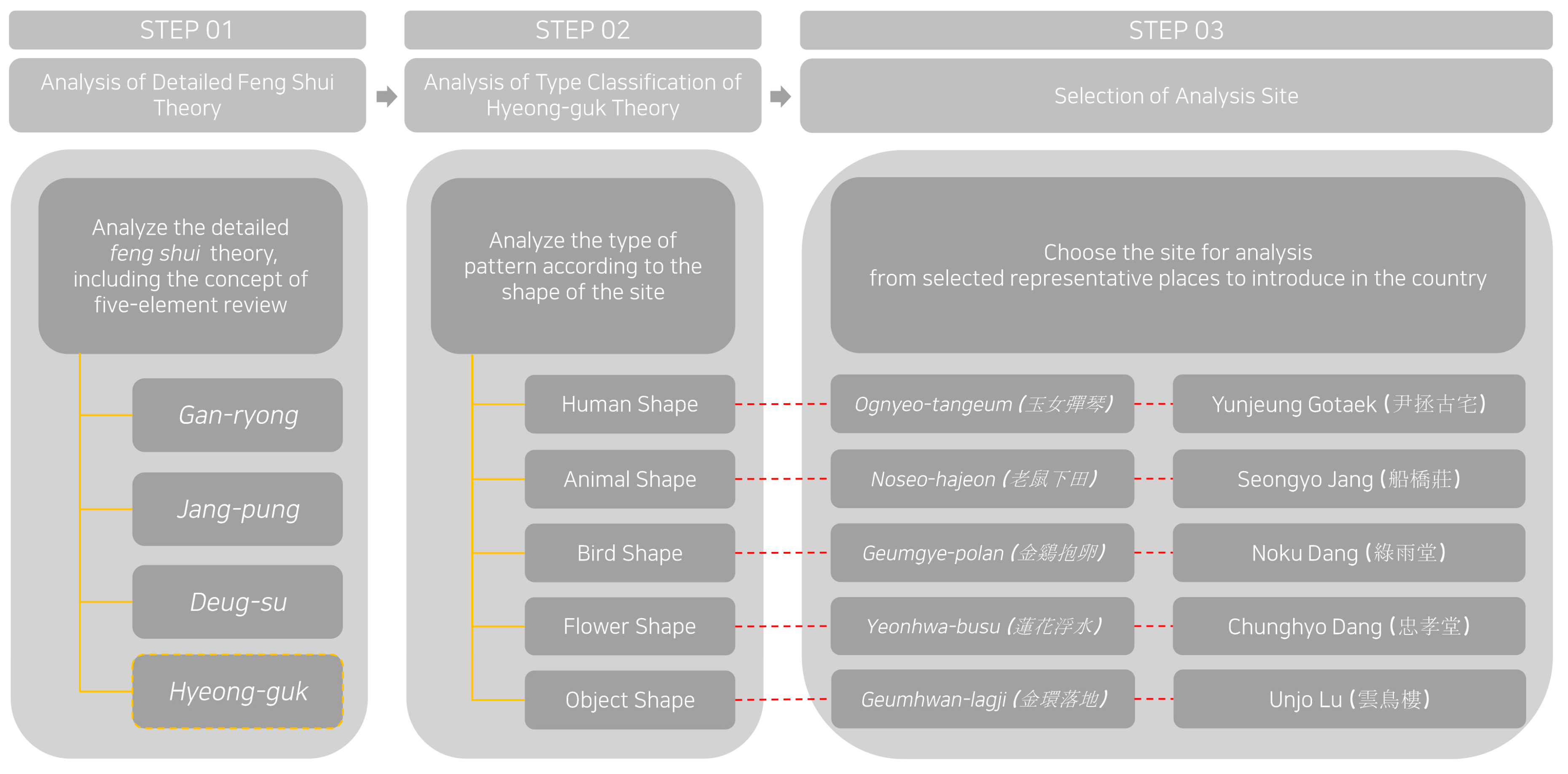
Feng shui thoughts are mainly divided into two ideas: (1)
yang-taek, meaning selection guidelines for the living environment including houses (called
hanok in Korea), schools, and shops; and (2)
eum-taek, to choose the site for dead people, such as shrines and tombs [
4].
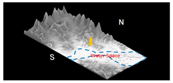
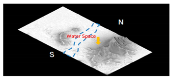
Figure 1 exemplifies two different sites using 3D geographical mapping according to those concepts. Especially, the
hyeong-guk method, translated as the investigation theory for land formality based on the two basic ideas stated above, is useful because it provides comprehensive assessment indexes for the surrounding natural and topographic settings [
5]. Therefore, this study tries to carry out the applicability of
feng shui principles toward the G-SEED system as a Korean standard for green building guidelines by setting up contents of the
hyeong-guk method that divides the surrounding environment of the building site into classified hierarchical geographies and examines all natural elements holistically.
Feng shui studies have been performed in East Asian cities, including in China, since the 20th century, especially focusing on interpretations and applications of its internal principles. As its paradigm has changed, more detailed
feng shui studies are now on the way to determine whether
feng shui is related to a specific factor among environmental properties for current trends in ecologies. Mak’s study has categorized
feng shui thoughts into a compass idea that selects a site location using its orientation and the form theory that selects a place according to the shape of the terrain [
6]. Later, in Mak’s subsequent research based on the above previous research, an ideal topographical model reflecting geographical characteristics was proposed and presented using the concept of
myeong-dang, which is used to find the best location. Furthermore, the similarity in design alternatives found by contemporary architects relative to the principle of the traditional
feng shui theory was verified [
7]. Dong’s research in 2011 compared the East and the West geographic philosophies that incorporated the notion of sustainability through comprehensive data from thirteen projects in the field of urban design for four Chinese cities [
8]. As a result, an assessment model of urban sustainability was suggested.
On the other hand, in an article by Chen and Nakama, “A Study on Village Forest Landscape in Small Island Topography in Okinawa, Japan,” a physical indicator in the range of the forest that is essential for the review of
feng shui was selected [
9]. In that study, the forest layout was investigated by considering the condition of the landscape, such as topography and wood density, from a visual point of view [
9]. Magli’s recent study in 2018 examined the role of
feng shui thoughts from the aspect of orientation selection through analyses of satellite images toward the Chinese royal tombs [
10]. Likewise,
feng shui thoughts are expanding in influence as critical research themes that not only have a direct relationship among interdisciplinary principles such as architecture, ecology, and geography, but also have indirect relations with fields such as consumer psychology and economics. Advanced studies have also been conducted to increase the applicability of
feng shui through comparative reviews and scientific verifications of
feng shui thoughts and theories of ecological architecture, especially in Korea, as follows.
According to a thesis by Jeong, it is necessary to analyze the principle of
feng shui in terms of geography with topography that is relevant to its effects on the human body by choosing a type of the best residential location with surrounding natural environments [
11]. In a thesis entitled “A Study on Modern Understanding of Geological Theory of Feng-Sui Based on Site for Residential Area,” Yoon has also emphasized that continuous trials to modernize
feng shui ideas are required to apply them to contemporary urban and/or architectural processes [
12]. In addition, Lee has examined fundamental principles for evaluating the external environment of the residential area and suggested its assessment elements in terms of
feng shui ideology [
13].
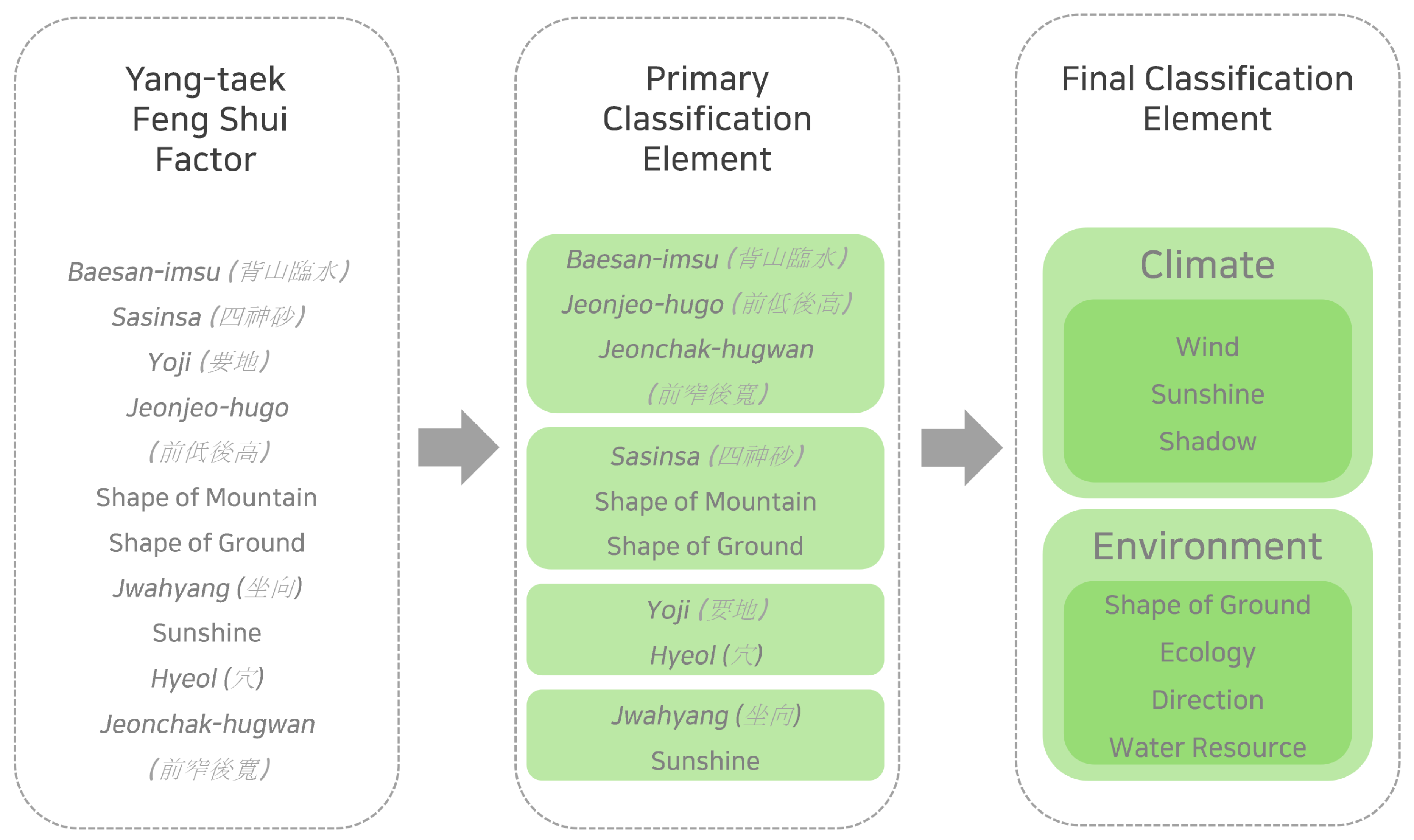
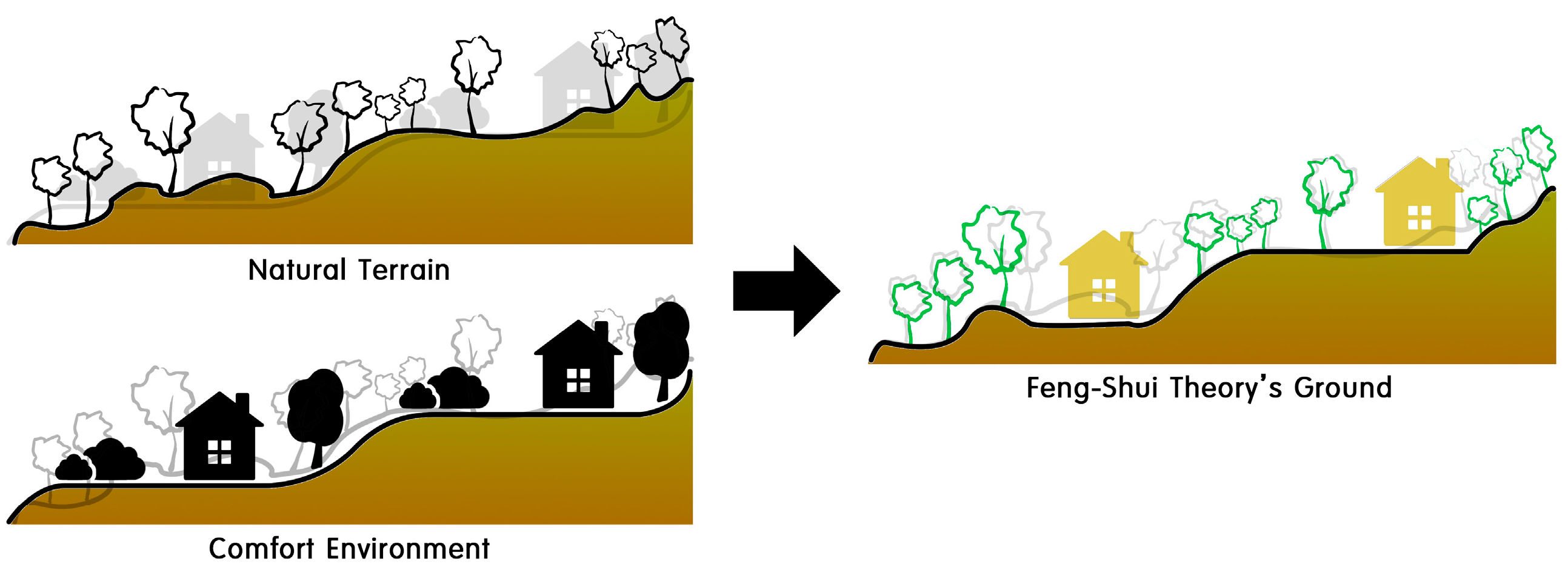
One of the most important concepts in
feng shui is the shape of surrounding lands and terrain when selecting the location of buildings.
Baesan-imsu (meaning “securing rivers in front and mountains behind the building”) and
jeonjeo-hugo (low front side and high back side) are representative ideas to be considered during the process. On the other hand,
donggo-seojeo (high east side and low west side) and
seogo-dongjeo as its contrasting concept are also referable ideas regarding site conditions suggested by the
hyeong-guk theory among the
feng shui thoughts mentioned previously [
14,
15]. That is, natural factors mainly used in the method of selecting locations using
feng shui are mountain compositions and terrain types. Its specific elements tend to be classified in somewhat empirical terms. Most representative natural indexes can be divided into climatic and environmental factors. Their details are normally determined by land topographies, mountain flows, water layouts, and orientations around the site [
16]. Finally, representative evaluation elements derived using the frequency that appear in theories of
feng shui are summarized in
Figure 2.
On the other hand, the concept of ecological architecture has emerged with the change of principles and policies to overcome recent continuous problematic issues, such as excessive resource consumption and severe environmental pollution, appearing worldwide since the industrial revolution [
3,
17,
18]. In particular, the concept of green architecture has emerged as one of the major environmental design trends. The concept of sustainable development has been radically developed since the Earth Summit held in 1992 by the United Nations. According to Massod’s recent research in 2017, the green architecture has been suggested as a mega trend that normally focuses on the relationship between architecture and nature, enabling energy to be used in new ways, such as solar and wind renewals, to meet both basic requirements of the ecological architecture and user needs [
18].
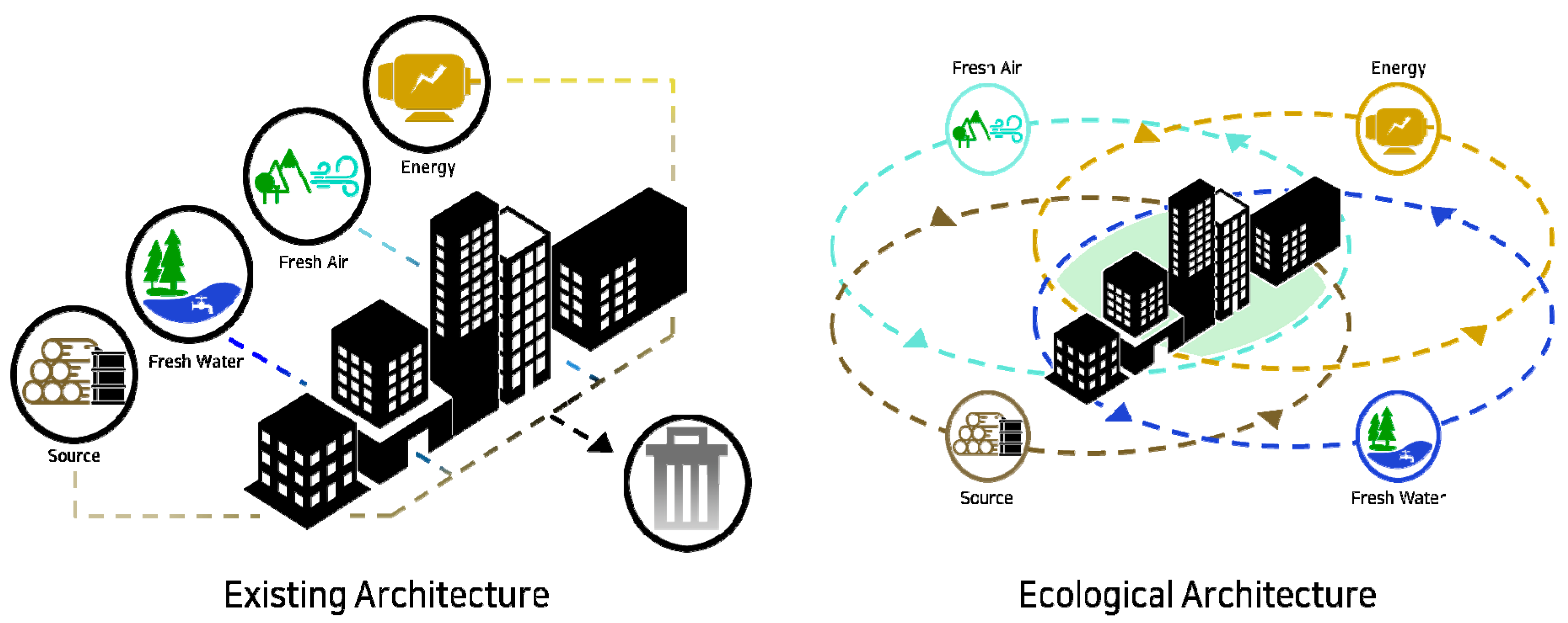
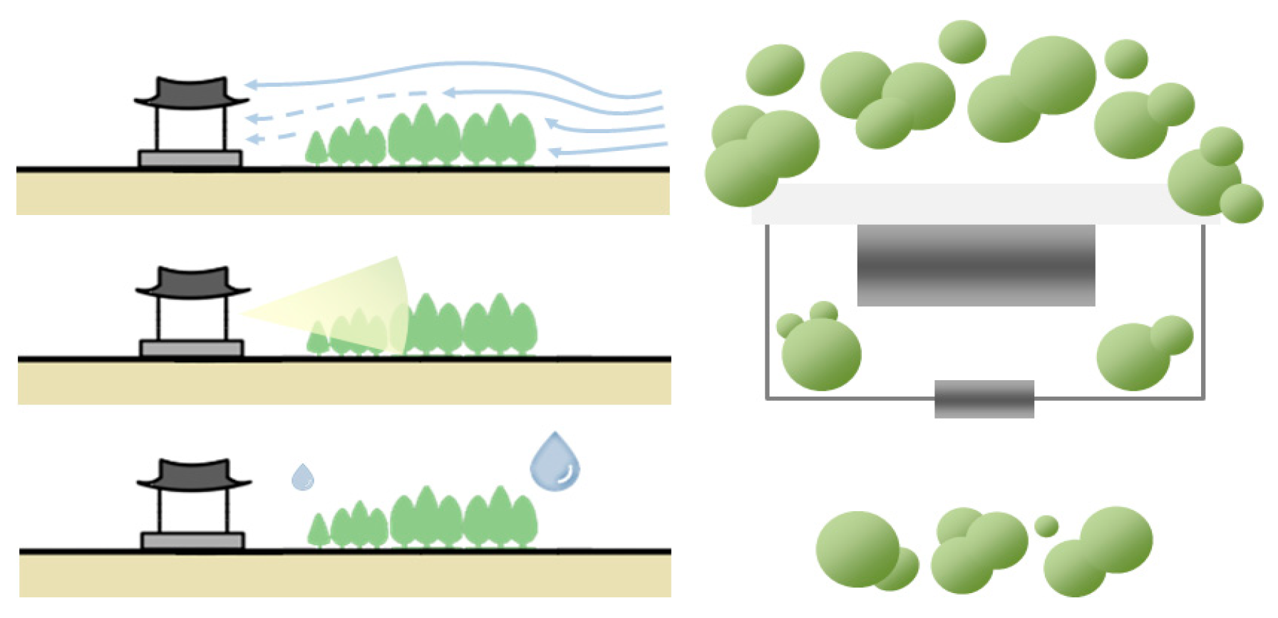
In this sense, the coexistence of the micro-biosphere and the human residential environment is essential for the realization of ecological architecture. It is also important to utilize potential natural energy sources and implement efficient resource circulation system in buildings to be self-sufficient, if possible [
19,
20]. Therefore, design principles from ecological architecture can greatly influence energy properties to acquire natural resources such as those from the soil, water, wind, and sun. They can also affect spatial planning characteristics, including environmental adaptation, systemic building circulation, ecological diversity, economic independency in terms of the energy, and so on, as described in
Figure 3 [
2,
11].
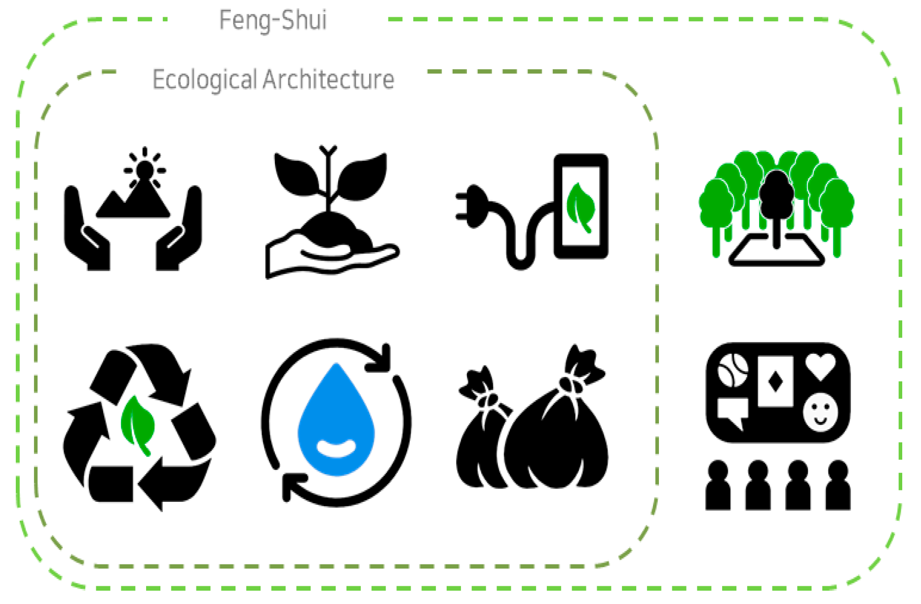
The most significant commonality, therefore, can be considered the main evaluation index between
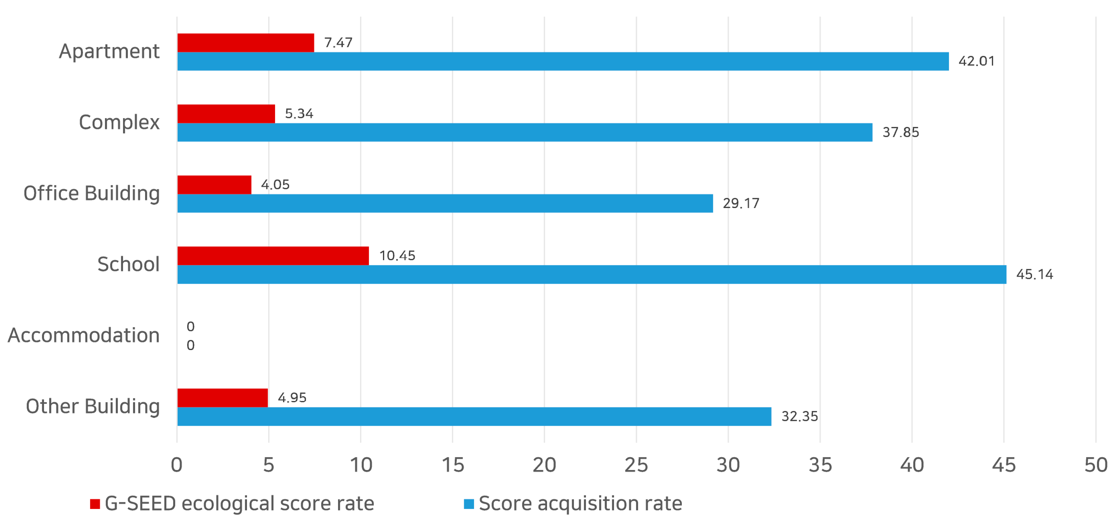
feng shui thoughts and the theory of ecological architecture. It is a fundamental idea to create a high-quality residential environment that aims to improve the coexistence of humans, architecture, nature, and the ecosystem. G-SEED is a certification system for environment-friendly buildings in Korea. However, it has ambiguous evaluation criteria for ecological value in comparison with other international systems. Its score proportion is relatively low for most facilities, as shown on
Figure 4, because its subcategorized indexes are considered as optional factors regardless of the significance. In fact, the evaluation criteria for energy efficiency are more weighted than those in the ecological value in terms of the score acquisition ratio in G-SEED [
21].
G-SEED does not consider the unique climate and environment conditions of the Korean peninsula. Instead, it acquired principles of ecological architecture with the global ecosystem in mind under the influence of BREEAM [
1]. Unfortunately, this situation means G-SEED has limited use regarding Korean own traditional environmental identities inherited from the past. To overcome this weakness, it is necessary to consider the difference between traditional buildings in terms of eco-friendliness and reveal its applicability as an assessment tool. It is expected that valuable clues can be provided through comparative analyses on multiple attempts toward the adaptation of
feng shui thoughts.
Doam et al. have insisted through their article that: “BREEAM is considered as the strongest rating system at present.” They mentioned that: “Currently, no rating scheme could assess a project in all aspects of sustainability.” These contexts mean that environmental assessment systems, including BREEAM, may have limitations as an effective assessment tool [
22]. Mattoni et al. have also conducted a comparative study in their research paper entitled “Critical Review and Methodological Approach to Evaluate the Differences Among International Green Building Rating Tools” about five internationally recognized environmental certification schemes (BREEAM, LEED, CASBEE, Green Star, and ITACA). They have indicated that all these systems do not show the same evaluation results, although these systems can be used as an evaluation tool for each associative country [
23]. Accordingly, critical characteristics can be derived from each different environment in which its own green certification system is used. It could be said that a definite difference exists between countries depending on traditional concepts of the region. Therefore, G-SEED also needs to consider both universal assessment factors that can be presented through the GBRS (Green Building Rating System) and traditional evaluation factors reflecting Korean regionalism simultaneously.
3. Results
3.1. Topographic Analyses for Target Sites
Many previous analyses on terrains containing
feng shui elements have been done regarding various aspects. However, physical features, such as position, relationship, and direction, as surrounding elements judged using 2D-based pictures are only presented in Magli’s research entitled “Royal Mausoleums of the Western Han and of the Song Chinese Dynasties: A Satellite Imagery Analysis,” where
feng shui is approached in terms of geography [
10,
48]. On the contrary, it may not be possible to consider environmental conditions separately from the geographical aspect if the research is conducted in terms of an environmental aspect, as presented previously in Chang’s article [
28]. Therefore, this study implemented 3D digital map data as analysis clues for selected areas to overcome the limitation of utilizing 2D images. This study also presented advantages of the terrain aspects in actual
feng shui contexts using planar and cross-sectional analyses to see if all requirements regarding the topography were met.
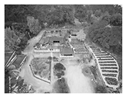
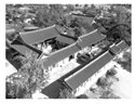
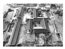
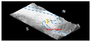
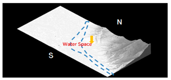
Terrain analyses for each site were conducted first to examine the topography and biosphere to determine whether the laid contours were actually reflecting the concepts found in feng shui thoughts. It could be analyzed using 3D mapping after manipulating geographic data obtained from Google. It was found that topographic elements of each site were located at each suitable place for performing a function as the protective boundary. It was also found that all sites met the basic requirement for climatic and environmental conditions presented in feng shui thoughts, although there was a difference in shape according to the type classification in the hyeong-guk theory. Therefore, it is possible to make an extensive judgment using feng shui thoughts during the planning process, including a site selection.
In the case of YT-01, a mountain was found in the back of the whole site as a baesan formation. Its southern side was open while its northern side was closed. Its topography followed the typical style of jeonjeo-hugo, where the front space was widely open. There was an artificial pond in front of the building with streams flowing southward and eastward. Next, YT-02 lay along the Taebaek mountain from the back to the west. It basically had a geomorphic structure called jeonjeo-hugo westward and eastward due to its property as a mountainous area. Its water space, however, flowed from the reservoir located on the southwest part of the site to the stream in the west side.
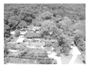
The geographical characteristics of YT-03 were different from those of others. It showed typical morphological features called
baesan surrounded by mountains since the mountain was situated on the east side through the northwest side starting from its southern direction. Streams on the west side of the site flowed southward through to northward from the Yeondong reservoir as the origin. In the case of YT-04, high mountainous areas were located on the southeast side from the south side of the site. It was characterized by the concept of
donggo-seojeo where the plain was open to the west. Nakdong river ran on three sides of the village. It had a unique shape due to its wide width. Its shape looked like the letter “S”. In the case of YT-05, Jiri mountain extended to the back of the site from the south side. Its overall terrain also showed characteristics of
jeonjeo-hugo. Seomjin river ran from its west side to the south. The water flowed in the form of the letter “L,” showing geographical characteristics of the typical
baesan-imsu. All analyses of site topography are as summarized in
Table 3.
As a result of the topographic analysis of five target sites in each area, two common features could be derived. First, all sites show the structural characteristics of myeong-dang, such as baesan-imsu and jeonjeo-hugo presented by feng shui thoughts, despite the fact that the compositional layout of mountains and rivers around each site was different. Second, the mountainous area and the water space were normally located where they can play a protective role according to the topographical and geographical characteristics of the site. For instance, Gangreung had a geomorphic advantage. In this sense, it can prevent winter winds from the northwest side within the range of the Taebaek mountain. Andong was also in a position where the wide river could play a role of cutting out winds.
Previous attempts, including Magli’s work, using satellite image data supported by Google have used a general method in terms of geography. However, multi-dimensional analysis could not properly be utilized for the target location since planar analysis was the only option to be performed [
29]. In addition, this method could generate critical errors due to differences between data checked on the map and those obtained from actual terrains. Therefore, 3D data utilization has advantages for analyzing the modern applicability of
feng shui thought more closely to see the topographical shape of the target site, the actual distance between major terrain elements including water space and the plain, the angle of the cross-section for the site, and so on.
3.2. Climatic Analyses of Target Sites
Chen and Cheung have considered forests and terrain elements to identify beneficial effects on both psychological and physical aspects of the human living environment. For this reason, the terrain including vegetation could be utilized as a factor for evaluating target sites in terms of
feng shui thoughts [
9,
49]. Therefore, it is necessary to understand the physical role of topographical characteristics in conventional climate analysis. To this end, this study included a simple review using the wind rose, a common way to analyze local climate. The wind rose has been employed by several studies [
50,
51,
52]. At the same time, this research determined topographical advantages of the wind for the location. The wind rose tool was used to determine whether there were obstacles in the terrain for the direction of the wind by inserting it into 2D and 3D geometric data for target sites. It is necessary to examine external environmental conditions for target
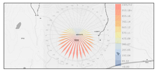
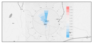
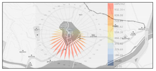
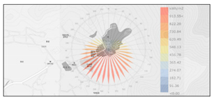
myeong-dang sites in addition to the topographical analyses performed above. By utilizing simulation algorithms called “ladybug with grasshopper”, general analyses on thermal and wind environments were conducted and meaningful data for solar radiations and/or air flows were derived, as shown in
Table 4.
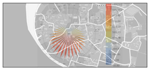
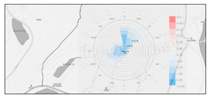
The annual solar radiation of 950.18 kW/m2 on the south side situated at 180° was seen in the case of YT-01 due to its open geomorphic structure. The site also had an advantage in securing natural heating energy in the winter. The wind speeds were up to 13.54 m/s in the winter season from the north (N) through the northwest (NW) direction to the site. It became possible to use selective winds entering the residential area because the rear mountain was blocking chilly winds efficiently. The case of YT-02 also indicated an insolation of 932 kW/m2 in the direction of 190° shifted slightly to the west based on the south side. It showed the advantage of acquiring solar radiation due to its geomorphic structure similar to the case of YT-01. The wind at YT-02 from the west (W) was the strongest at 28.62 m/s. In addition, its indirect blow-ins was made effective for the site by filtering it with Taebaek mountain range on its west side. The case of YT-03 had a relatively low ratio of open land to the south as opposed to previous sites. It had 913.55 kW/m2 of annual solar radiation from the southwest direction at 210°. This seemed to reflect regional climatic characteristics in the site selection process. The wind from the north (N) shows the strongest speed at 24.63 m/s. The rear mountain also played a role as a windbreak forest in this case.
The case of YT-04 in Hahoe Village had an average annual solar radiation of 949.55 kW/m2 from the southwest at 200°. The adjacent Nakdong river surrounded the site from the west, south, and north directions and formed a relatively wide water space. Thus, potential terrain elements were quite spaced from the site. Its geographical aspect was also advantageous for forming the solar environment. In addition, mountains located beyond the wide river were primarily functioning to filter the inflow of north (N) and northwest (WNW) winds. Comparatively, in the case of YT-05, the site had an annual radiation of 967.9 kW/m2 from the southwestern direction at 200°. This seemed beneficial for making an ideal solar environment because there were no terrain elements obstructing the inflow of daylight to the south. The wind speed was up to 12.45 m/s from the northeast direction (NE). The Jiri mountain located on its north side also played a role as a windproof system to filter improper winds.
As a result of the comparative climate analysis for the five target sites, it can be concluded that these buildings tended to be located in a place where the geographical condition was set up so that target sites could control the climatic elements like the sun and wind according to local characteristics. It is also worth noting that terrain of the surrounding environment around the site was normally used as a passive control system to optimize the inflow of solar radiation and winds depending on the climatic conditions of the area where the myeong-dang was located. The concept of feng shui recognized as an ideological perception may be regarded as a consideration for understanding the microclimate of the site due to regional climate characteristics of the Korean peninsula. Thus, it can be inferred that feng shui thoughts are supported by a sufficient scientific basis and that the current environmental index can possibly be interpreted in or replaced with the traditional point of view.
Mak’s research has employed only theoretical settings by simply reviewing climatic elements inherent in
feng shui thoughts. It lacks verification of the effect of the climate in terms of environmental aspects [
6,
7]. Of course, it is essential to study how to extract those elements inferred scientifically because
feng shui principles tend to imply qualitative concepts with a limit on being able to contemporarily apply it for environmental assessment in this way. Therefore, characteristics of climate data should be identified and applied to the topography using the graph while examining external systems, such as wind and radiation roses, to analyze the effect of topography on climate. Such methods are very useful to grasp the main characteristics of the regional climate. They have been verified by many previous studies [
51,
52,
53]. However, the uniqueness of
feng shui thoughts need to be further assessed since its concept is additionally introduced from a contemporary point of view.
3.3. Environmental Analyses of Target Sites
It is necessary to derive quantitative results in environmental analyses based on numerical data that can be supported by climate analysis for each site, although climatic factors, such as wind and water, but not the sun, may be differentiated by various factors that make up the structure, such as the shape, arrangement, and the function of the building in addition to the formation of the site, including surrounding environmental conditions. Thus, environmental analyses were mainly performed in the scope of optical and thermal settings, while all climate and environmental factors, including the sun, wind, terrain, biosphere, and water mentioned in the previous chapter, were employed for relevant investigations.
This analysis partially referred to Jalal’s research [
54]. The general exposure time for the seasonal sun was calculated using the sun path method based on solar altitude, latitude, and orientation in Korea utilizing virtual 3D models reflecting topographical characteristics. Solar exposure time was calculated for five target sites and compared with the average solar exposure time in Korea to examine whether each site differed from the average data or not. In addition, the above exemplified study aimed to set the direction of the building by examining the amount of insolation only [
50]. Comparatively, this present study aimed to further identify the impact of the sun on the environment. Thus, this study finally designed an analysis process by creating UTCI (universal thermal climatic index) values to see its possible effects on human comfort.
Therefore, environmental analyses were focused on lighting and heating conditions influenced by the sun. They are presented in this chapter. This study was focused on the exposure of the sun in the environment around the target area by obtaining the UTCI that was the heat index of the external space. It simulated the PMV (predicated mean vote) UTCI to examine whether these sites were utilizing solar resources properly to create comfort in terms of lighting, heating, and cooling. Simulation analyses were executed and thermal characteristics based on sun exposure distributions for target sites were meaningfully mapped, as summarized in
Table 5.
The case of YT-01 showed relatively constant daily sun exposure for 10–11 hours in summer and 9–10 hours in winter. It is considered to be the most efficient place in terms of sustainability and seasonal availability of solar resources [
37,
38]. On the other hand, YT-02 was the place with the largest gap for daily sun exposure (12–13 hours in summer and 8–9 hours in winter). This was probably due to morphological characteristics of the uneven terrain due to the Taebaek mountains and angular change of solar incidence.
In the case of YT-03, daily sun exposure time was 10–11 hours in summer and 8–9 hours in winter. Among the target sites, YT-03 had the shortest daily sun exposure time. The target site also showed a relatively uniform distribution of solar exposure throughout the year. Thus, solar resource utilization was likely to be consistent at this site. The sun exposure at YT-04 showed a big difference between summer and winter with 12–13 hours daily in summer and 9–10 hours daily in winter. YT-05 had the highest daily exposure time with 13–14 hours in summer and 11–12 hours in winter. This may be attributed to the typical topographical characteristics of baesan-imsu and jeonjeo-hugo.
Basically, every target site was exposed to the sun for more than 10 hours daily in summer and more than 8 hours daily in winter, although there was a difference in the exposure time from a minimum of 1 hour to a maximum of 3 hours for each site in summer. All sites had higher solar exposure times compared to mean daily values for the Korean peninsula (7.72 hours in the summer and 6.61 hours in the winter, as provided by the Korean Meteorological Yearbook in 2018).
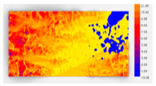
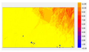
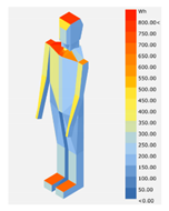
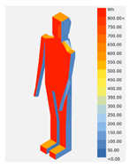
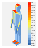
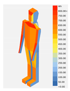
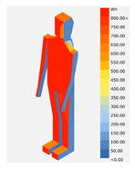
Next, analyses of the solar radiation environment for target sites were performed using equivalent data achieved in the previous step with the same analysis method. Comfort mannequin (CM) analyses are shown in
Table 6. They were conducted with an orientation of the south side at 180° to estimate the amount of solar radiation flowing into the target site for typical summer and winter days differentiated by regional characteristics. Statistical climate data provided by contents from EPW (EnergyPlus Weather) files were utilized.
The case of YT-01 showed the lowest radiation value among target sites (at 795 Wh in summer and 618 Wh in winter) regardless of the season. Its CM also had the lowest distribution of the absolute solar radiation compared to others due to its lower solar exposure time. In the case of YT-02, the second highest value for solar irradiance was observed as 845 Wh in summer and 1017 Wh in winter. It had features showing that the time of the maximum solar irradiance during the summer was in the morning due to the fact that the Taebaek mountains toward the west coast of Korea were partially blocking sunbeams in the afternoon.
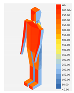
YT-03 had seasonal solar radiation at 964 Wh in summer and 842 Wh in winter based on its CM analyses. This was environmentally advantageous for reducing the cooling load because of the lower amount of solar radiation entering the building in summer and reduced the heating load in winter due to increasing solar radiation, even in winter. YT-04 had solar radiation of 821 Wh in summer and 1077 Wh in winter with the largest difference between seasons for the sites analyzed. This site had a favorable environmental advantage for creating residential settings since its solar radiation in summer was lower than that at other sites while having the highest solar radiation in winter as well. YT-05 had solar radiation of 899 Wh in summer and 951 Wh in winter based on its CM analyses, meaning that it had lower solar radiance in contrast with its solar exposure time. In summary, the thermal environment in terms of the solar radiation could commonly be summarized for most target sites. It tended to become low in summer. Its inflow amount increased in winter, although their absolute values seemed to be different from each other due to the differing surroundings. This phenomenon was especially notable at YT-02 and YT-04.
As a result, it could be concluded that the solar energy in the winter was higher than that in the summer by confirming the amount of solar radiant incidences facing the south direction between both seasons using CM analysis models. This means that all target sites received relatively little excess heat for the solar inflow in summer as a thermal energy source. This fact could be highlighted as an advantage of the place controlled by traditional principles and methods that have been intended to induce winter solar radiation the most.
Thermal analyses for target
myeong-dang sites were based on CM analyses as described above. Further examinations were performed, assuming the effects of introduced heats on human residents using UTCI, the temperature sensitivity index. First, the solar UTCI was applied regarding solar resources. A typical UTCI was assumed for the opposite case. Comparative analyses were conducted to reveal differences between the above two UTCI values measured at the same time and to examine the transition tendency of the comfort zone for each target site by calculating the PMV for external spaces based on UTCI values estimated in the previous step. In this way, differences between the maximum and average between solar and typical UTCIs could be simultaneously measured for all targets, as shown in
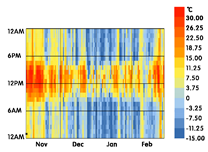
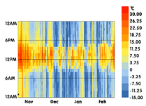
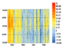
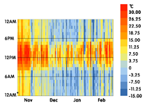
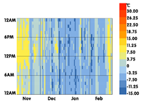
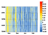
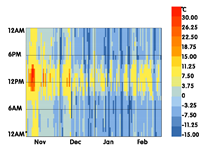
Table 7. It was found that the highest difference was 26.5 °C in the winter season at YT-01 and YT-05, where their average differences were 2.19 °C and 2.2 °C.
Solar UTCIs for all target sites in the winter season were at least 1.5 °C higher than typical UTCIs. Color changes according to the legend of the winter UTCI graph shown in
Table 8 indicate that solar UTCI values tended to increase with greater daylight hours. As a result, the case of YT-02, with the smallest effect from solar factors, showed a difference of 20.6 °C in the maximum solar UTCI and 1.4 °C for the average temperature difference during the measurement period. In addition, outdoor PMV analyses in the winter season for target sites could be calculated by analyzing thermal comfort, a qualitative evaluation index, regarding human satisfaction by using the above solar UTCI and MRT (mean radiant temperature) derived from typical UTCIs.
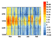
Table 9 shows graphs of PMV changes calculated using both UTCI values, especially for the winter season for five target sites. It confirms that the overall ratio of the comfort zone in yellow increased. According to this, all sites showed an increased rate of more than 6% in the comfort zone ratio. The case of YT-04 had the largest increment at 10.55%, in contrast with YT-03, which had the smallest increase rate at 6.94%. In addition, the trend of temperature change was clearly visible on UTCI graphs in winter for these target sites. Its numerical differences showed that the average UTCI exceeded 1.5 °C in all cases. The comfort zone rate increased from 6% to 10% in terms of PMV. In this way, it is possible to review thermal environments around targets to analyze the degree of solar resource acquisition that guarantees an advantage in creating a proper heating condition in the winter season.
UTCI is an index of thermal comfort for external spaces developed in the 2000s. This study basically benchmarked several studies [
46,
47,
48] regarding investigating definitions and usages of the UTCI, although its main methods have not been applied to any
feng shui study yet. This research then introduced UTCI for practical verification of
feng shui thoughts to evaluate the value of its uniqueness in terms of human comfort for the first time. Moreover, the average energy performance of the sun using the overall UTCI index could be calculated. As a result, target sites accepting
feng shui concepts and elements showed an efficiency of 10% or more on average, meaning that actual evidence of the proposed principle fully considers geographical aspects of target sites to utilize solar warmth effectively.
Occasionally, the cooling condition by utilizing natural winds in summer can be perceived as a significant environmental index for passive control. However, the heating utility for the winter season, like ondol or gudeul in traditional architecture, can be classified as an active control device that consumes fundamental resources, such as wood and straw. Thus, it is possible to minimize the use of active utilities for environmental control at the site to increase the sensation temperature on the human body by acquiring enough solar resources in winter. Therefore, it can be concluded that the solar resource emphasized in feng shui thoughts plays a role as an optimizer in energy consumption for building activities, as suggested by the current certification system like G-SEED.
In sum, the methods of energy use in traditional architecture has taken full advantage of the environment in which energy and resources can be acquired from natural elements. Passive control methods are prominent for optimizing the building environment and controlling the acquisition of excess energy sources. The higher the absolute value of the environmental performance that can replace the concept of energy efficiency obtained from natural factors, the more advantage to the site overall. It is also a meaningful attempt to incorporate
feng shui thoughts into the contemporary building process, although analysis contents are somewhat limited to the examination of solar radiation.
Table 10 provides suggestions for the G-SEED categories based on all previous analyses proposed in this research. In this sense, continuous trials for setting conditions dealing with more specific natural elements in the process of location selections based on
feng shui principles are needed as ongoing studies. In addition, constant scientific validations need to be conducted in accordance with various environmental factors. The role of
feng shui thoughts in interior space also needed to be determined in parallel as part of a future study.
4. Conclusions
Recently, there have been attempts to apply the concept of an artificial mountain in feng shui thoughts to evaluate the environment around contemporary urban buildings. The artificial mountain means the replacement of natural features using skyscrapers and high-rise facilities, for example. It can act as environment control devices in addition to topographical features like natural terrains and slopes in urban settings. However, it is still necessary to perform enough studies on the adaptation of feng shui thoughts to alternative objects like multi-storied buildings easily found in our living environments. It is also necessary to escape from the strict boundary of the traditional building for trying new investigations in terms of modernization.
G-SEED is currently used as a certification system for environment-friendly buildings in Korea. It includes a few criteria for assessing the surrounding environment, such as land use, traffic, and ecology. In the case of ecological area rate as one of those certification items, quantitative indicators and criteria are presented in a relative manner. However, the judgment basis in some specific categories, including the ecological value, remains qualitative. Their evaluation criteria have not been reached practically. There is only a subtraction factor as an assessment criterion for the use of ecological values. There is no reflection on contexts consistent with traditional values and localities. In this sense, this study attempted to interpret and apply the traditional viewpoint of the ecological role of the environmental system around the site using feng shui as a provider to evaluate indexes by examining its principle based on hyeong-guk methods.
The evaluation of the application of feng shui thoughts has been performed using qualitative judgment as to whether it conforms to typical topographies rather than objective numerical verifications as a whole. It is questionable whether the type-conforming terrain will match the same geographical advantage. Therefore, representative site types were selected and analyzed according to the guideline of feng shui thoughts to secure scientific clues achieved by recent simulation technologies. Targeted analyses were then conducted in a sequential manner to analyze the topography, climate, and environment for selected sites by applying wind rose, radiation distribution, solar exposure, and UTCI tools in a step-by-step process to determine whether each analysis site had climatic and environmental advantages.
As a result, all selected sites had geographical characteristics that could play a role as a windshield. They also had advantages as locations where daylight from the south was incident without any significant obstacle. In addition, all target sites had solar exposure for more than eight hours per day. The application of MRT values to UTCI indicated an increment of thermal sensation for the built environment. This led to the conclusion that they had strengths in terms of the utilization of natural and climatic factors according to the type classification of the hyeong-guk method using feng shui principles.
If there is only a subtraction factor in existing ecological values, inherent architectural values traditionally reflected from the past would possibly be ignored. Therefore, establishing Korea’s own certification system for eco-friendliness is needed by merging modern architectural values with traditional architectural values based on feng shui thoughts as evaluation criteria for ecological strategies. Furthermore, by seeking its applicability in conforming to the local identity, G-SEED is expected to play a role as part of a practical domestic certification system in the future.


