Complex Spatial Morphology of Urban Housing Price Based on Digital Elevation Model: A Case Study of Wuhan City, China


Abstract
1. Introduction
2. Models and Methods
2.1. Digital Elevation Model for Urban Housing Price
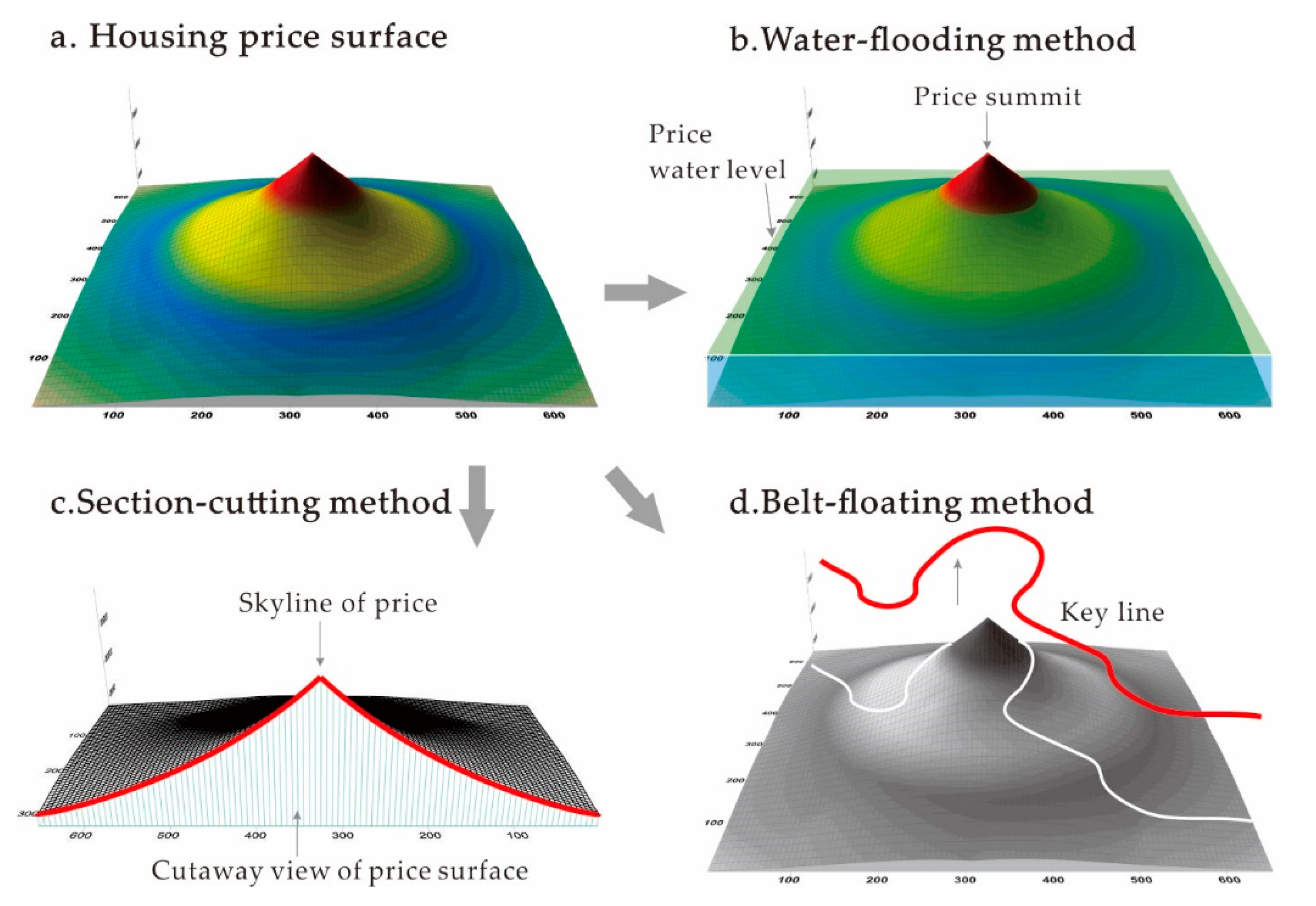
2.2. DEM-Based Analysis Method
- -
- The Water-flooding method (see Table 1), which uses the “water level” (a given benchmark housing price) at a designated height to analyze the high values and characteristics of the top area on the urban housing price surface (see Figure 1b). We simulate the flooding result of housing price by vertically changing the basic level of the original DEM model in ArcScene.
- -
- The Section-cutting method (see Table 1), which analyzes the side-view price skyline and gradient characteristics through section cutting in the specific directions (see Figure 1c). We cut and split the original DEM model according to the directions we set in ArcScene, and examine the gradient characteristics of housing price along the cutting lines.
- -
- The Belt-floating method (see Table 1), which is used to analyze spatial variance of the urban housing price DEM on the route of a specific line, such as a subway line (see Figure 1d). Specifically, we build a covering relation between traffic lines and DEM model surfaces in ArcScene to obtain housing price changes along the traffic routes.
3. Case Study Area and Materials
3.1. Study Area
3.2. Housing Price
4. Results
4.1. Urban Housing Price Surface
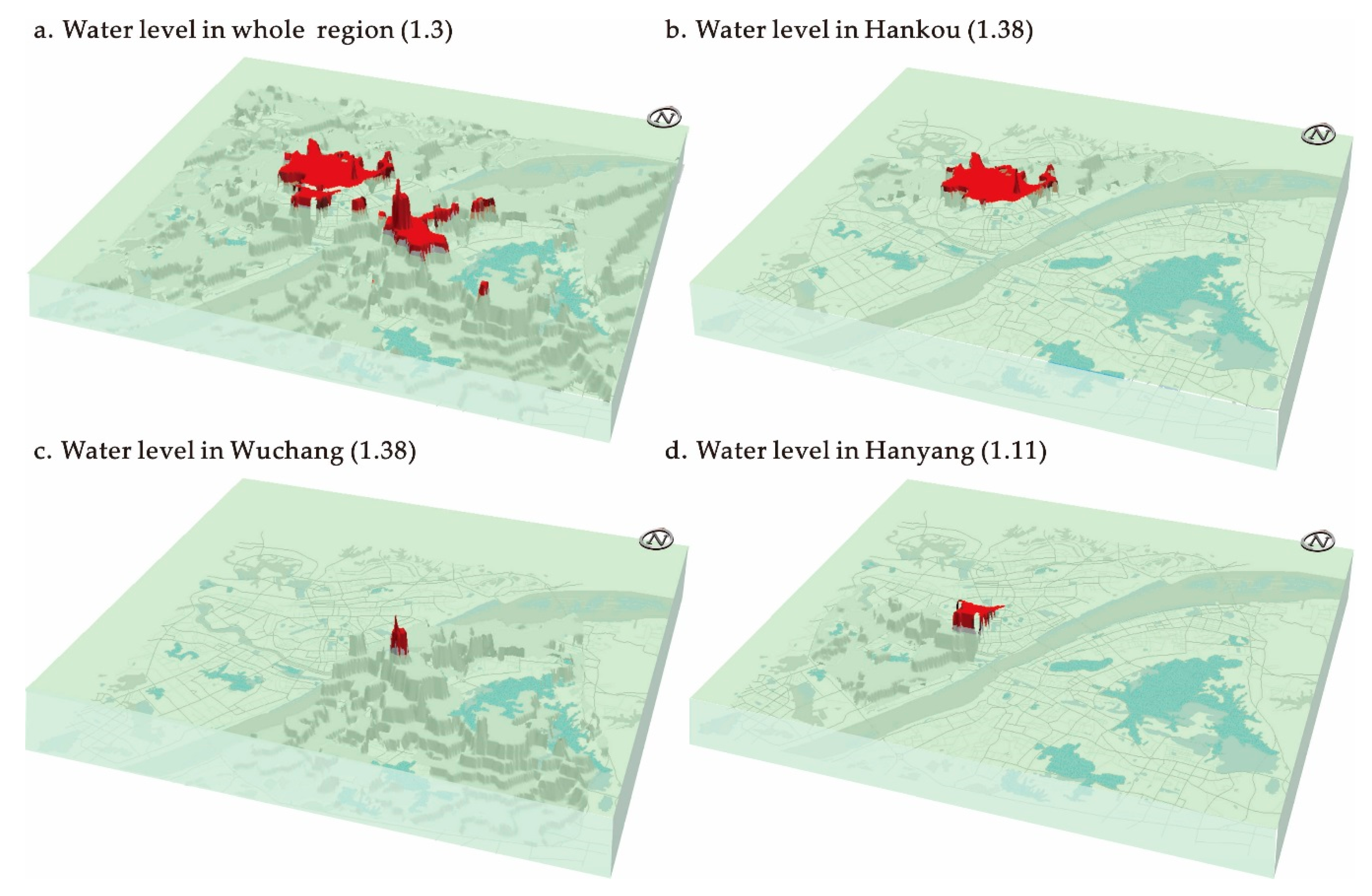
4.2. Water-Flooding: The Multi-Peak Changes of Surface
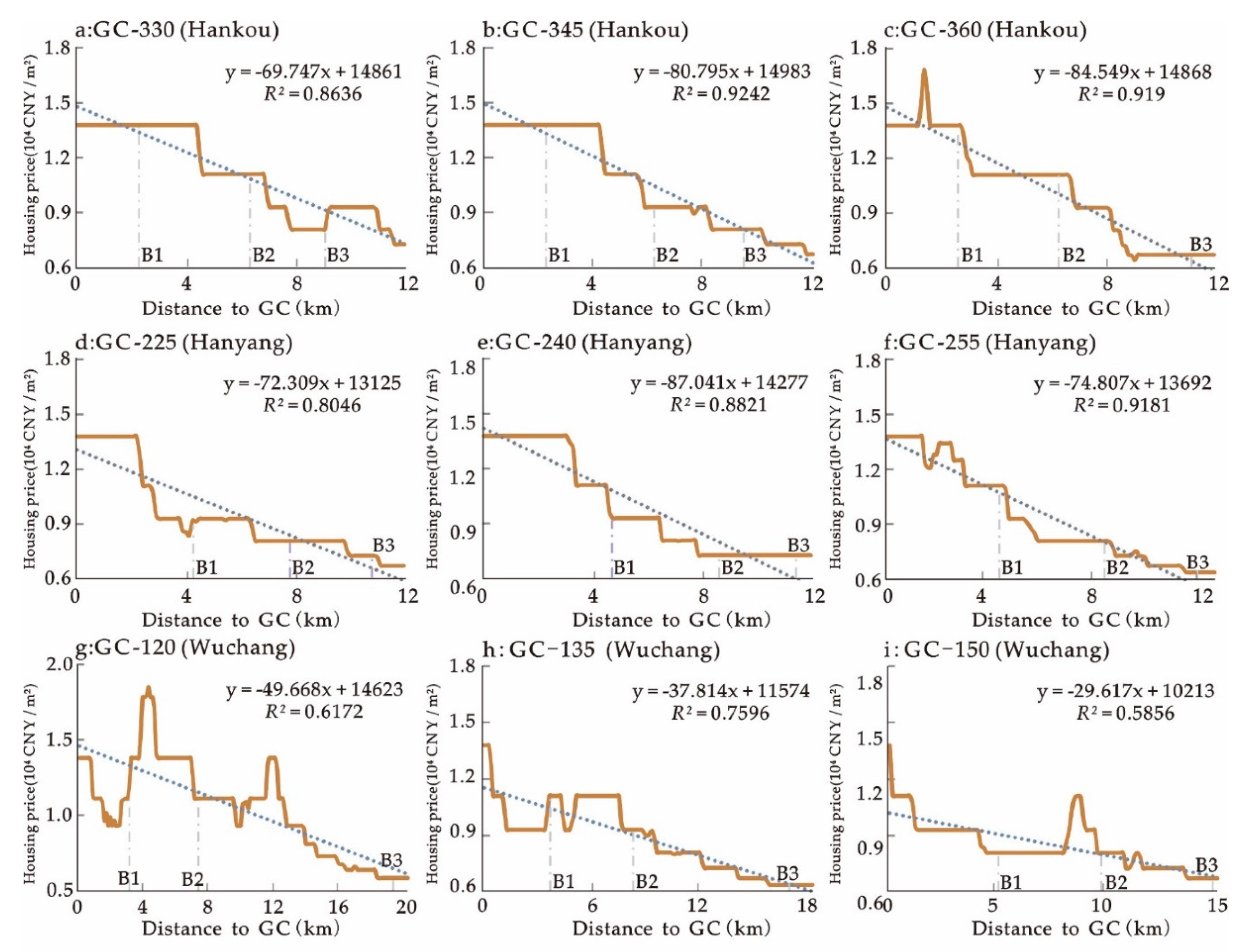
4.3. Section-Cutting: Spatial Morphology of Gradient in Side Views
4.4. Belt-Floating: Spatial Morphology along Key Traffic Lines
- (1)
- Spatial morphological visualization of housing prices along main subway lines. We consider the housing price as a proxy variable that reflects the spatial value, and intersect different subway lines and DEM surfaces for housing prices in the tri-dimensional space environment based on the DEM surface for housing prices in Wuhan City. Then, we further explore the characteristic morphology of spatial distribution along subway lines and complete visualization under different perspectives (see Figure 9). Globally, low-value areas appear on the starting point and the ending point of each line, while the high-value areas are usually distributed in the middle part of the line. Locally, different lines present complex multidimensional fluctuations.
- (2)
- Investigation of housing prices along subway lines. Considering the radioactive landscape of Wuhan City, we collected the price data on the DEM surface relating to different ring roads within the central urban area and compared these data. Through investigating the housing prices along different ring roads in different directions, we found that the prices tend to decrease from the first ring road to the third ring road in Hankou and Hanyang (see Figure 10a), which fits the radioactive spatial structure feature of Wuhan City. However, the housing price in Wuchang does not show a similar pattern. In some directions in Wuchang, the housing prices along the ring roads do not show a hierarchical distribution but display a fluctuation pattern. This feature is contrary to the spatial structure feature, but corresponding with the polycentric trends of the housing price morphology, as explored earlier. Besides, if sequenced from high to low along the ring roads, the housing prices also present an overall decline trend from first ring road to third ring road (see Figure 10b).
5. Concluding Discussion
Author Contributions
Funding
Acknowledgments
Conflicts of Interest
References
- Haggett, P.; Cliff, A.D.; Frey, A. Locational Analysis in Human Geography; Edward Arnold: London, UK, 1977. [Google Scholar]
- Alonso, W. Location and Land Use; Harvard University Press: Cambridge, UK, 1964. [Google Scholar]
- Mills, E.S. An Aggregative Model of Resource Allocation in a Metropolitan Area. Am. Econ. Rev. 1967, 57, 197–210. [Google Scholar]
- Mills, E.S. Studies in the Structure of the Urban Economy; Jones Hopkins Press: Baltimore, MD, USA, 1972. [Google Scholar]
- Muth, R.F. Cities and Housing; The University of Chicago Press: Chicago, IL, USA, 1969. [Google Scholar]
- Krugman, P.R. Development, Geography, and Economic Theory; MIT Press: Cambridge, MA, USA, 1995; pp. 595–599. [Google Scholar]
- Kloosterman, R.C.; Musterd, S. The Polycentric Urban Region: Towards a Research Agenda. Urban Stud. 2001, 38, 623–633. [Google Scholar] [CrossRef]
- Parr, J. The Polycentric Urban Region: A Closer Inspection. Reg. Stud. 2004, 38, 231–240. [Google Scholar] [CrossRef]
- Meijers, E.J.; Burger, M.J. Spatial structure and productivity in US metropolitan areas. Environ. Plan. A 2010, 42, 1383–1402. [Google Scholar] [CrossRef]
- Mori, T. Monocentric Versus Polycentric Models in Urban Economics. In The New Palgrave Dictionary of Economics; Palgrave Macmillan: London, UK, 2016; pp. 1–4. [Google Scholar]
- Burger, M.; Meijers, E. Form follows function? Linking morphological and functional polycentricity. Urban Stud. 2012, 49, 1127–1149. [Google Scholar] [CrossRef]
- Tian, G.; Wu, J.; Yang, Z. Spatial pattern of urban functions in the Beijing metropolitan region. Habitat Int. 2010, 34, 249–255. [Google Scholar] [CrossRef]
- Vasanen, A. Functional polycentricity: Examining metropolitan spatial structure through the connectivity of urban sub-centres. Urban Stud. 2012, 49, 3627–3644. [Google Scholar] [CrossRef]
- Wen, H.; Tao, Y. Polycentric urban structure and housing price in the transitional China: Evidence from Hangzhou. Habitat Int. 2015, 46, 138–146. [Google Scholar] [CrossRef]
- Qin, B.; Han, S.S. Emerging polycentricity in Beijing: Evidence from housing price variations, 2001–2005. Urban Stud. 2013, 50, 2006–2023. [Google Scholar] [CrossRef]
- Adolphson, M. Estimating a Polycentric Urban Structure. Case Study: Urban Changes in the Stockholm Region 1991–2004. J. Urban Plan. Dev. 2009, 135, 19–30. [Google Scholar] [CrossRef]
- Liu, X.; Derudder, B.; Wu, K. Measuring Polycentric Urban Development in China: An Intercity Transportation Network Perspective. Reg. Stud. 2015, 50, 1302–1315. [Google Scholar] [CrossRef]
- Liu, X.; Wang, M. How polycentric is urban China and why? A case study of 318 cities. Landsc. Urban Plan. 2016, 151, 10–20. [Google Scholar] [CrossRef]
- Ottensmann, J.R.; Payton, S.; Man, J. Urban Location and Housing Prices within a Hedonic Model. J. Reg. Anal. Policy 2012, 38, 19–35. [Google Scholar]
- Zhang, Z.; Tang, W. Analysis of spatial patterns of public attention on housing prices in Chinese cities: A web search engine approach. Appl. Geogr. 2016, 70, 68–81. [Google Scholar] [CrossRef]
- Law, S. Defining Street-based Local Area and measuring its effect on house price using a hedonic price approach: The case study of Metropolitan London. Cities 2017, 60, 166–179. [Google Scholar] [CrossRef]
- Bajic, V. The Effects of a New Subway Line on Housing Prices in Metropolitan Toronto. Urban Stud. 2014, 20, 147–158. [Google Scholar] [CrossRef]
- Wen, H.; Bu, X.; Qin, Z. Spatial effect of lake landscape on housing price: A case study of the West Lake in Hangzhou, China. Habitat Int. 2014, 44, 31–40. [Google Scholar] [CrossRef]
- Lansford, N.H., Jr.; Jones, L.L. Recreational and aesthetic value of water using hedonic price analysis. J. Agric. Resour. Econ. 1995, 20, 341–355. [Google Scholar]
- Wen, H.; Zhang, Y.; Zhang, L. Do educational facilities affect housing price? An empirical study inHangzhou, China. Habitat Int. 2014, 42, 155–163. [Google Scholar] [CrossRef]
- Sun, C.; Meng, X.; Peng, S. Effects of Waste-to-Energy Plants on China’s Urbanization: Evidence from a Hedonic Price Analysis in Shenzhen. Sustainability 2017, 9, 475. [Google Scholar] [CrossRef]
- Rosato, P.; Breil, M.; Giupponi, C.; Berto, R. Assessing the Impact of Urban Improvement on Housing Values: A Hedonic Pricing and Multi-Attribute Analysis Model for the Historic Centre of Venice. Buildings 2017, 7, 112. [Google Scholar] [CrossRef]
- Bilbao-Terol, C.; Cañal-Fernández, V.; Valdés, L.; Valle, E.D. Rural Tourism Accommodation Prices by Land Use-Based Hedonic Approach: First Results from the Case Study of the Self-Catering Cottages in Asturias. Sustainability 2017, 9, 1688. [Google Scholar] [CrossRef]
- Won, J.; Lee, J.S. Investigating How the Rents of Small Urban Houses are Determined: Using Spatial Hedonic Modeling for Urban Residential Housing in Seoul. Sustainability 2017, 10, 31. [Google Scholar] [CrossRef]
- Huang, H.; Yin, L. Creating sustainable urban built environments: An application of hedonic house price models in Wuhan, China. J. Hous. Built Environ. 2014, 30, 1–17. [Google Scholar] [CrossRef]
- Tao, X.; Ming, Z.; Aditjandra, P.T. The impact of urban rail transit on commercial property value: New evidence from Wuhan, China. Transp. Res. Part A Policy Pract. 2016, 91, 223–235. [Google Scholar]
- Xu, T.; Zhang, M. Tailoring empirical research on transit access premiums for planning applications. Transp. Policy 2016, 51, 49–60. [Google Scholar] [CrossRef]
- Mcmillen, D.P.; Mcdonald, J.F. A Nonparametric Analysis of Employment Density in a Polycentric City. J. Reg. Sci. 1997, 37, 591–612. [Google Scholar] [CrossRef]
- Mcmillen, D.P. The return of centralization to Chicago: Using repeat sales to identify changes in house price distance gradients. Reg. Sci. Urban Econ. 2003, 33, 287–304. [Google Scholar] [CrossRef]
- Openshaw, S. Computational Human Geography: Towards a Research Agenda. Environ. Plan. A 1994, 26, 499–505. [Google Scholar]
- Hu, S.; Cheng, Q.; Wang, L.; Xie, S. Multifractal characterization of urban residential land price in space and time. Appl. Geogr. 2012, 34, 161–170. [Google Scholar] [CrossRef]
- Hu, S.; Yang, S.; Li, W.; Zhang, C.; Xu, F. Spatially non-stationary relationships between urban residential land price and impact factors in Wuhan city, China. Appl. Geogr. 2016, 68, 48–56. [Google Scholar] [CrossRef]
- Chica-Olmo, J. Prediction of Housing Location Price By a Multivariate Spatial Method: Cokriging. J. Real Estate Res. 2007, 29, 95–114. [Google Scholar]
- Chica-Olmo, J.; CanoGuervos, R.; ChicaOlmo, M. A Coregionalized Model to Predict Housing Prices. Urban Geogr. 2013, 34, 395–412. [Google Scholar] [CrossRef]
- Martínez, M.G.; Lorenzo, J.M.M.; Rubio, N.G. Kriging methodology for regional economic analysis: Estimating the housing price in Albacete. Int. Adv. Econ. Res. 2000, 6, 438–450. [Google Scholar] [CrossRef]
- Olmo, J.C. Spatial Estimation of Housing Prices and Locational Rents. Urban Stud. 1995, 32, 1331–1344. [Google Scholar] [CrossRef]
- Zhang, Z.; Tan, S.; Tang, W. A GIS-based Spatial Analysis of Housing Price and Road Density in Proximity to Urban Lakes in Wuhan City, China. Chin. Geogr. Sci. 2015, 25, 775–790. [Google Scholar] [CrossRef]
- Dubin, R.A. Predicting House Prices Using Multiple Listings Data. J. Real Estate Financ. Econ. 1998, 17, 35–59. [Google Scholar] [CrossRef]
- Anselin, L.; Syabri, I.; Kho, Y. GeoDa: An Introduction to Spatial Data Analysis. Geogr. Anal. 2005, 38, 5–22. [Google Scholar] [CrossRef]
- Montero, J.M.; Mínguez, R.; Fernández-Avilés, G. Housing price prediction: Parametric versus semi-parametric spatial hedonic models. J. Geogr. Syst. 2017, 20, 1–29. [Google Scholar] [CrossRef]
- Cellmer, R. The Possibilities and Limitations of Geostatistical Methods in Real Estate Market Analyses. Real Estate Manag. Svaluation 2014, 22, 54–62. [Google Scholar] [CrossRef]
- Montero, J.M.; Fernández-Avilés, G.; Mateu, J. Spatial and Spatio-Temporal Geostatistical Modeling and Kriging; John Wiley & Sons: Hoboken, NJ, USA, 2015. [Google Scholar]
- Montero-Lorenzo, J.M.; Larraz-Iribas, B.; Páez, A. Estimating commercial property prices: An application of cokriging with housing prices as ancillary information. J. Geogr. Syst. 2009, 11, 407–425. [Google Scholar] [CrossRef]
- Mcmillen, D. Identifying Sub-centres Using Contiguity Matrices. Urban Stud. 2003, 40, 57–69. [Google Scholar] [CrossRef]
- Mcmillen, D.P. Nonparametric Employment Subcenter Identification. J. Urban Econ. 2001, 50, 448–473. [Google Scholar] [CrossRef]
- Redfearn, C.L. The topography of metropolitan employment: Identifying centers of employment in a polycentric urban area. J. Urban Econ. 2007, 61, 519–541. [Google Scholar] [CrossRef]
- Lv, G.N.; Xiong, L.; Chen, M.; Tang, G.A.; Sheng, Y.H.; Liu, X.J.; Song, Z.Y.; Lu, Y.; Yu, Z.Y.; Zhang, K.; et al. Chinese progress in geomorphometry. J. Geogr. Sci. 2017, 27, 1389–1412. [Google Scholar] [CrossRef]
- Grohmann, C.H.; Smith, M.J.; Riccomini, C. Multiscale Analysis of Topographic Surface Roughness in the Midland Valley, Scotland. IEEE Trans. Geosci. Remote Sens. 2011, 49, 1200–1213. [Google Scholar] [CrossRef]
- Xiong, L.Y.; Tang, G.A.; Li, F.Y.; Yuan, B.Y.; Lu, Z.C. Modeling the evolution of loess-covered landforms in the Loess Plateau of China using a DEM of underground bedrock surface. Geomorphology 2014, 209, 18–26. [Google Scholar] [CrossRef]
- Guo, W.Q.; Liu, S.Y.; Peng-Chun, Y.U.; Jun-Li, X.U. Automatic extraction of ridgelines using on drainage boundaries and aspect difference. Sci. Surv. Mapp. 2011, 6, 75. [Google Scholar]
- Dipasquale, D.; Wheaton, W.C. Urban Economics and Real Estate Markets; Prentice Hall: Upper Saddle River, NJ, USA, 1996; pp. 289–299. [Google Scholar]
- Xiao, Y. Hedonic Housing Price Theory Review. In Urban Morphology and Housing Market; Springer: Berlin, Germany, 2017; pp. 11–40. [Google Scholar]
- Kiel, K.A.; Zabel, J.E. Location, location, location: The 3L Approach to house price determination. J. Hous. Econ. 2008, 17, 175–190. [Google Scholar] [CrossRef]
- Shimizu, C. Estimation of Hedonic Single-Family House Price Function Considering Neighborhood Effect Variables. Sustainability 2014, 6, 2946–2960. [Google Scholar] [CrossRef]
- Meese, R.; Wallace, N. Nonparametric Estimation of Dynamic Hedonic Price Models and the Construction of Residential Housing Price Indices. Real Estate Econ. 2010, 19, 308–332. [Google Scholar] [CrossRef]
- Krige, D.G. A Statistical Approach to Some Basic Mine Valuation Problems on the Witwatersrand. J. South. Afr. Inst. Min. Metall. 1951, 52, 119–139. [Google Scholar]
- Matheron, G. Principles of geostatistics. Econ. Geol. 1963, 58, 1246–1266. [Google Scholar] [CrossRef]
- Cressie, N.A.C. Statistics for Spatial Data, Revised Edition; Wiley: New York, NY, USA, 1993. [Google Scholar]
- Lloyd, C.D. Local Models for Spatial Analysis; CRC Press: Boca Raton, FL, USA, 2006. [Google Scholar]
- Gichamo, T.Z.; Popescu, I.; Jonoski, A.; Solomatine, D. River cross-section extraction from the ASTER global DEM for flood modeling. Environ. Model. Softw. 2012, 31, 37–46. [Google Scholar] [CrossRef]
- Schäppi, B.; Perona, P.; Schneider, P.; Burlando, P. Integrating river cross section measurements with digital terrain models for improved flow modelling applications. Comput. Geosci. 2010, 36, 707–716. [Google Scholar] [CrossRef]
- Tate, E.C.; Maidment, D.R.; Olivera, F.; Anderson, D.J. Creating a terrain model for floodplain mapping. J. Hydrol. Eng. 2002, 7, 100–108. [Google Scholar] [CrossRef]
- Han, S.S.; Wu, X. Wuhan. Cities 2004, 21, 349–362. [Google Scholar] [CrossRef]
- Jiao, L.; Liu, Y. Geographic Field Model based hedonic valuation of urban open spaces in Wuhan, China. Landsc. Urban Plan. 2010, 98, 47–55. [Google Scholar] [CrossRef]
- Tse, R.Y.C. Estimating Neighbourhood Effects in House Prices: Towards a New Hedonic Model Approach. Urban Stud. 2011, 39, 1165–1180. [Google Scholar] [CrossRef]
- Case, B.; Clapp, J.; Dubin, R.; Rodriguez, M. Modeling Spatial and Temporal House Price Patterns: A Comparison of Four Models. J. Real Estate Financ. Econ. 2004, 29, 167–191. [Google Scholar] [CrossRef]
- Dubin, R.; Pace, R.K.; Thibodeau, T.G. Spatial Autoregression Techniques for Real Estate Data. J. Real Estate Lit. 1999, 7, 79–96. [Google Scholar] [CrossRef]
- Pace, R.K.; Lesage, J.P. Spatial Statistics and Real Estate. J. Real Estate Financ. Econ. 1998, 17, 5–13. [Google Scholar] [CrossRef]
- Smith, M.J.D.; Goodchild, M.F.; Longley, P.A. Geospatial Analysis: A Comprehensive Guide to Principles, Techniques and Software Tools, 2nd ed.; Troubador Publishing Ltd.: Leicester, UK, 2007. [Google Scholar]


| Method | Basic Formula | Form | Implement Description |
|---|---|---|---|
| Water-flooding | where zb is the given benchmark price (“water lever”) | surface | investigate the peaks of a surface above a given horizontal plane of housing price |
| Section-cutting | where xi or yi is the given position of cross-section | polyline or curved line | examine the profile or cross-section of an urban housing surface along a selected straight line or a series of straight line segments |
| Belt-floating | where is the given route of a key transit line | space curve | detect the elevation from the housing surface along the route of a specific line |
| Statistical Description | Maximum | Minimum | Average | Standard Deviation |
|---|---|---|---|---|
| Housing price (CNY ¥ ▪ m−2) | 23,800 | 5140 | 9015.41 | 2775.32 |
| Distance to GC (km) | 18.42 | 1.33 | 7.45 | 4 |
© 2019 by the authors. Licensee MDPI, Basel, Switzerland. This article is an open access article distributed under the terms and conditions of the Creative Commons Attribution (CC BY) license (http://creativecommons.org/licenses/by/4.0/).
Share and Cite
Zhang, Z.; Lu, X.; Zhou, M.; Song, Y.; Luo, X.; Kuang, B. Complex Spatial Morphology of Urban Housing Price Based on Digital Elevation Model: A Case Study of Wuhan City, China. Sustainability 2019, 11, 348. https://doi.org/10.3390/su11020348
Zhang Z, Lu X, Zhou M, Song Y, Luo X, Kuang B. Complex Spatial Morphology of Urban Housing Price Based on Digital Elevation Model: A Case Study of Wuhan City, China. Sustainability. 2019; 11(2):348. https://doi.org/10.3390/su11020348
Chicago/Turabian StyleZhang, Zuo, Xinhai Lu, Min Zhou, Yan Song, Xiang Luo, and Bing Kuang. 2019. "Complex Spatial Morphology of Urban Housing Price Based on Digital Elevation Model: A Case Study of Wuhan City, China" Sustainability 11, no. 2: 348. https://doi.org/10.3390/su11020348
APA StyleZhang, Z., Lu, X., Zhou, M., Song, Y., Luo, X., & Kuang, B. (2019). Complex Spatial Morphology of Urban Housing Price Based on Digital Elevation Model: A Case Study of Wuhan City, China. Sustainability, 11(2), 348. https://doi.org/10.3390/su11020348