Integration of Ecosystem Services in Regional Spatial Plans in Western Switzerland


Abstract
1. Introduction
2. Methods
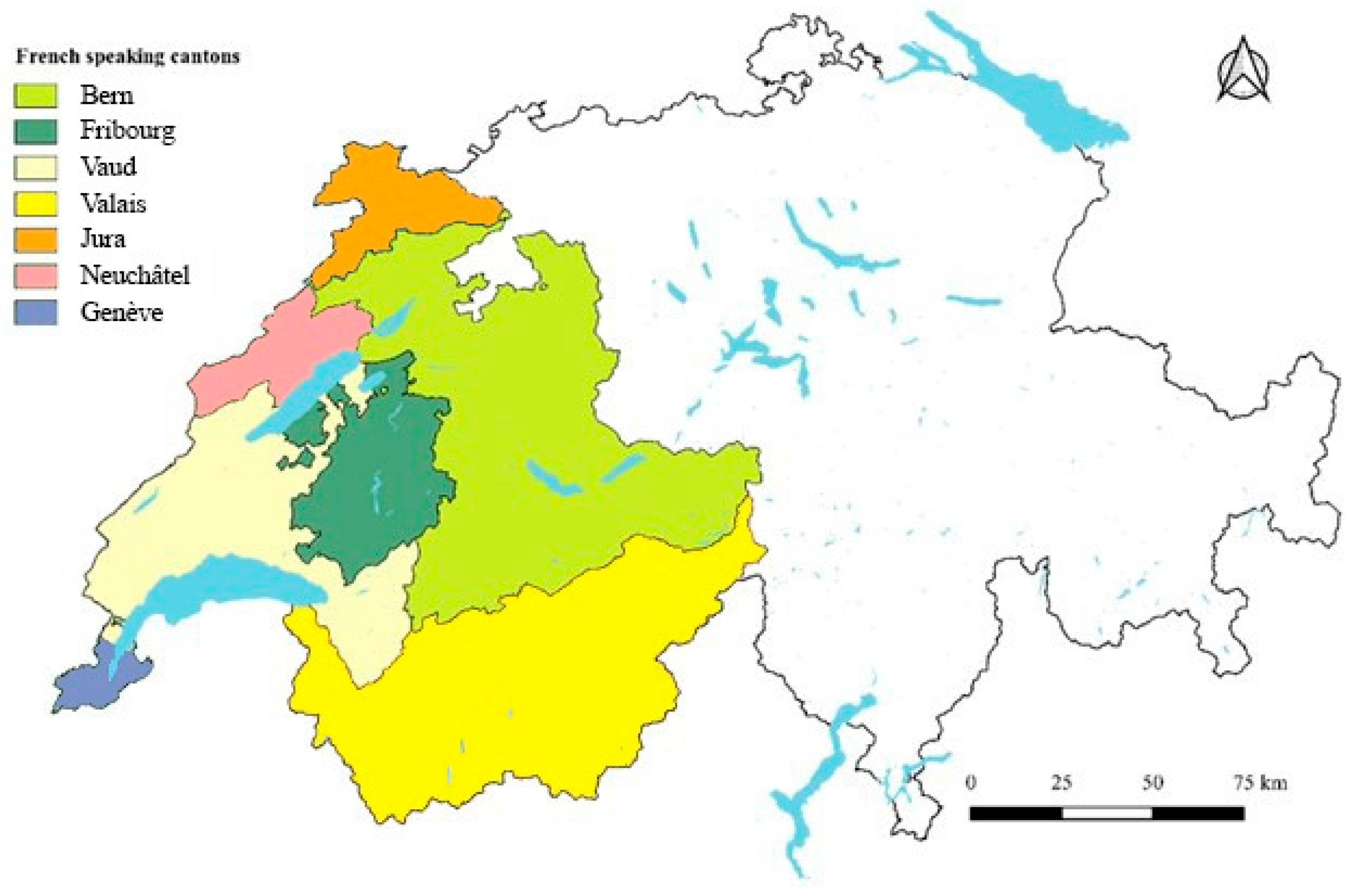
2.1. Study Area
2.2. Framework for Analysing the Integration of ES into Structural Plans
2.3. Directed Content Analysis
2.3.1. Integration of ES in Structural Plan Components
2.3.2. Difference in ES Integration Across Cantons
2.3.3. Binding and Nonbinding Operational Parts
3. Results
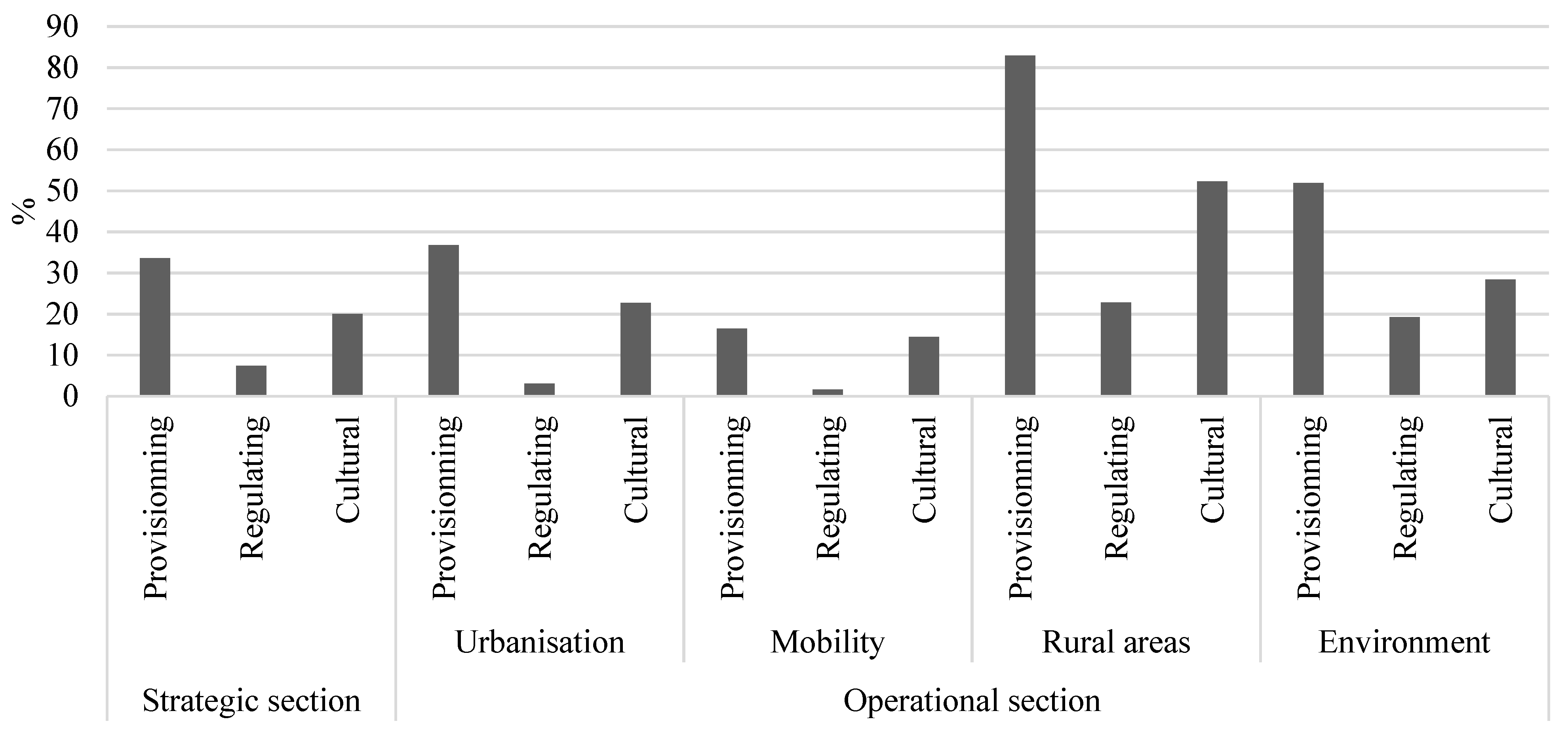
3.1. Frequency of ES Mention in Structural Plan Components
3.2. ES integration Across Cantons
3.3. Binding vs. Nonbinding Operational Parts
4. Discussion
4.1. Discussion of Results
4.1.1. Harmonizing ES Representation in Plan Components
4.1.2. Discrepancies in ES integration Across Cantons
4.1.3. Binding and Nonbinding Integration of ES Across Cantons
4.1.4. Requirements for Coordination Across Cantons
4.2. Discussion of Methods
5. Conclusions
Author Contributions
Funding
Acknowledgments
Conflicts of Interest
References
- Geneletti, D. Reasons and options for integrating ecosystem services in strategic environmental assessment of spatial planning. Int. J. Biodivers. Sci. Ecosyst. Serv. Manag. 2011, 7, 143–149. [Google Scholar] [CrossRef]
- Rozas-Vásquez, D.; Fürst, C.; Geneletti, D.; Almendra, O. Integration of ecosystem services in strategic environmental assessment across spatial planning scales. Land Use Policy 2018, 71, 303–310. [Google Scholar] [CrossRef]
- Lester, S.E.; Costello, C.; Halpern, B.S.; Gaines, S.D.; White, C.; Barth, J.A. Evaluating tradeoffs among ecosystem services to inform marine spatial planning. Mar. Policy 2013, 38, 80–89. [Google Scholar] [CrossRef]
- Opdam, P.; Steingröver, E.; Van Rooij, S. Ecological networks: A spatial concept for multi-actor planning of sustainable landscapes. Landsc. Urban Plan. 2006, 75, 322–332. [Google Scholar] [CrossRef]
- Selman, P. Planning for landscape multifunctionality. Sustain. Sci. Pract. Policy 2009, 5, 45–52. [Google Scholar] [CrossRef]
- Almenar, J.B.; Rugani, B.; Geneletti, D.; Brewer, T. Integration of ecosystem services into a conceptual spatial planning framework based on a landscape ecology perspective. Landsc. Ecol. 2018, 33, 2047–2059. [Google Scholar] [CrossRef]
- De Vreese, R.; Leys, M.; Fontaine, C.M.; Dendoncker, N. Social mapping of perceived ecosystem services supply–The role of social landscape metrics and social hotspots for integrated ecosystem services assessment, landscape planning and management. Ecol. Indic. 2016, 66, 517–533. [Google Scholar] [CrossRef]
- Grêt-Regamey, A.; Bebi, P.; Bishop, I.D.; Schmid, W.A. Linking GIS-based models to value ecosystem services in an Alpine region. J. Environ. Manag. 2008, 89, 197–208. [Google Scholar] [CrossRef]
- Gómez-Baggethun, E.; Barton, D.N. Classifying and valuing ecosystem services for urban planning. Ecol. Econ. 2013, 86, 235–245. [Google Scholar] [CrossRef]
- Scott, A.; Carter, C.; Hardman, M.; Grayson, N.; Slaney, T. Mainstreaming ecosystem science in spatial planning practice: Exploiting a hybrid opportunity space. Land Use Policy 2018, 70, 232–246. [Google Scholar] [CrossRef]
- Scolozzi, R.; Morri, E.; Santolini, R. Delphi-based change assessment in ecosystem service values to support strategic spatial planning in Italian landscapes. Ecol. Indic. 2012, 21, 134–144. [Google Scholar] [CrossRef]
- McKenzie, E.; Posner, S.; Tillmann, P.; Bernhardt, J.R.; Howard, K.; Rosenthal, A. Understanding the use of ecosystem service knowledge in decision making: Lessons from international experiences of spatial planning. Environ. Plan. C Gov. Policy 2014, 32, 320–340. [Google Scholar] [CrossRef]
- Turkelboom, F.; Leone, M.; Jacobs, S.; Kelemen, E.; García-Llorente, M.; Baró, F.; Termansen, M.; Barton, D.N.; Berry, P.; Stange, E.; et al. When we cannot have it all: Ecosystem services trade-offs in the context of spatial planning. Ecosyst. Serv. 2018, 29, 566–578. [Google Scholar] [CrossRef]
- Cortinovis, C.; Geneletti, D. Ecosystem services in urban plans: What is there, and what is still needed for better decisions. Land Use Policy 2018, 70, 298–312. [Google Scholar] [CrossRef]
- Kazak, J.K.; van Hoof, J. Decision support systems for a sustainable management of the indoor and built environment. Indoor Built Environ. 2018, 27, 1303–1306. [Google Scholar] [CrossRef]
- Grêt-Regamey, A.; Altwegg, J.; Sirén, E.A.; van Strien, M.J.; Weibel, B. Integrating ecosystem services into spatial planning—A spatial decision support tool. Landsc. Urban Plan. 2017, 165, 206–219. [Google Scholar] [CrossRef]
- Ahern, J.; Cilliers, S.; Niemelä, J. The concept of ecosystem services in adaptive urban planning and design: A framework for supporting innovation. Landsc. Urban Plan. 2014, 125, 254–259. [Google Scholar] [CrossRef]
- De Groot, R.S.; Alkemade, R.; Braat, L.; Hein, L.; Willemen, L. Challenges in integrating the concept of ecosystem services and values in landscape planning, management and decision making. Ecol. Complex. 2010, 7, 260–272. [Google Scholar] [CrossRef]
- Mouchet, M.A.; Paracchini, M.L.; Schulp, C.J.E.; Stürck, J.; Verkerk, P.J.; Verburg, P.H.; Lavorel, S. Bundles of ecosystem (dis)services and multifunctionality across European landscapes. Ecol. Indic. 2017, 73, 23–28. [Google Scholar] [CrossRef]
- Mouchet, M.A.; Rega, C.; Lasseur, R.; Georges, D.; Paracchini, M.L.; Renaud, J.; Stürck, J.; Schulp, C.J.; Verburg, P.H.; Verkerk, P.J.; et al. Ecosystem service supply by European landscapes under alternative land-use and environmental policies. Int. J. Biodivers. Sci. Ecosyst. Serv. Manag. 2017, 13, 342–354. [Google Scholar] [CrossRef]
- Laurans, Y.; Rankovic, A.; Billé, R.; Pirard, R.; Mermet, L. Use of ecosystem services economic valuation for decision making: Questioning a literature blindspot. J. Environ. Manag. 2013, 119, 208–219. [Google Scholar] [CrossRef]
- Langemeyer, J.; Gómez-Baggethun, E.; Haase, D.; Scheuer, S.; Elmqvist, T. Bridging the gap between ecosystem service assessments and land-use planning through Multi-Criteria Decision Analysis (MCDA). Environ. Sci. Policy 2016, 62, 45–56. [Google Scholar] [CrossRef]
- Fürst, C.; Opdam, P.; Inostroza, L.; Luque, S. Evaluating the role of ecosystem services in participatory land use planning: Proposing a balanced score card. Landsc. Ecol. 2014, 29, 1435–1446. [Google Scholar] [CrossRef]
- Kaczorowska, A.; Kain, J.H.; Kronenberg, J.; Haase, D. Ecosystem services in urban land use planning: Integration challenges in complex urban settings—Case of Stockholm. Ecosyst. Serv. 2016, 22, 204–212. [Google Scholar] [CrossRef]
- Mascarenhas, A.; Ramos, T.B.; Haase, D.; Santos, R. Participatory selection of ecosystem services for spatial planning: Insights from the Lisbon Metropolitan Area, Portugal. Ecosyst. Serv. 2016, 18, 87–99. [Google Scholar] [CrossRef]
- Uhde, B.; Hahn, W.A.; Griess, V.C.; Knoke, T. Hybrid MCDA methods to integrate multiple ecosystem services in forest management planning: A critical review. Environ. Manag. 2015, 56, 373–388. [Google Scholar] [CrossRef]
- Piwowarczyk, J.; Kronenberg, J.; Dereniowska, M.A. Marine ecosystem services in urban areas: Do the strategic documents of Polish coastal municipalities reflect their importance? Landsc. Urban Plan. 2013, 109, 85–93. [Google Scholar] [CrossRef]
- Wilkinson, C.; Saarne, T.; Peterson, G.D.; Colding, J. Strategic spatial planning and the ecosystem services concept—A historical exploration. Ecol. Soc. 2013, 18, 37. [Google Scholar] [CrossRef]
- Geneletti, D.; Zardo, L. Ecosystem-based adaptation in cities: An analysis of European urban climate adaptation plans. Land Use Policy 2016, 50, 38–47. [Google Scholar] [CrossRef]
- Rozas-Vásquez, D.; Fürst, C.; Geneletti, D.; Muñoz, F. Multi-actor involvement for integrating ecosystem services in strategic environmental assessment of spatial plans. Environ. Impact Assess. Rev. 2017, 62, 135–146. [Google Scholar] [CrossRef]
- Hansen, R.; Frantzeskaki, N.; McPhearson, T.; Rall, E.; Kabisch, N.; Kaczorowska, A.; Kain, J.H.; Artmann, M.; Pauleit, S. The uptake of the ecosystem services concept in planning discourses of European and American cities. Ecosyst. Serv. 2015, 12, 228–246. [Google Scholar] [CrossRef]
- Rall, E.L.; Kabisch, N.; Hansen, R. A comparative exploration of uptake and potential application of ecosystem services in urban planning. Ecosyst. Serv. 2015, 16, 230–242. [Google Scholar] [CrossRef]
- Frank, S.; Fürst, C.; Witt, A.; Koschke, L.; Makeschin, F. Making use of the ecosystem services concept in regional planning—Trade-offs from reducing water erosion. Landsc. Ecol. 2014, 29, 1377–1391. [Google Scholar] [CrossRef]
- Messer, M.A.; Bonroposi, M.; Chenal, J.; Hasler, S.; Niederoest, R. Gérer Les Meilleures Terres Agricoles En Suisse Pratiques Cantonales Et Perspectives D’évolution—Rapport Final. 2016. Available online: https://infoscience.epfl.ch/record/218371/files/RAPPORT%20FINAL-FR.pdf (accessed on 22 March 2017).
- Hersperger, A.M.; Mueller, G.; Knöpfel, M.; Siegfried, A.; Kienast, F. Evaluating outcomes in planning: Indicators and reference values for Swiss landscapes. Ecol. Indic. 2017, 77, 96–104. [Google Scholar] [CrossRef]
- Schneider, M.K.; Homburger, H.; Scherer-Lorenzen, M.; Lüscher, A. Intensité de pâture et services écosystémiques dans les alpages. Rech. Agron. Suisse 2013, 4, 222–229. [Google Scholar]
- Brunner, S.H.; Huber, R.; Grêt-Regamey, A. A backcasting approach for matching regional ecosystem services supply and demand. Environ. Model. Softw. 2016, 75, 439–458. [Google Scholar] [CrossRef]
- Rewitzer, S.; Huber, R.; Grêt-Regamey, A.; Barkmann, J. Economic valuation of cultural ecosystem service changes to a landscape in the Swiss Alps. Ecosyst. Serv. 2017, 26, 197–208. [Google Scholar] [CrossRef]
- ARE. Plans Directeur Cantonaux. 2018. Available online: https://www.are.admin.ch/are/fr/home/developpement-et-amenagement-du-territoire/strategie-et-planification/plans-directeurs-cantonaux.html (accessed on 15 August 2018).
- SFSO (Swiss Federal Statistical Office). Annuaire Statistique de la Suisse 2018. 2018. Available online: https://www.bfs.admin.ch/bfs/fr/home/statistiques/catalogues-banques-donnees/publications/ouvrages-synthese/annuaire-statistique-suisse.assetdetail.4522228.html (accessed on 25 May 2018).
- SFSO (Swiss Federal Statistical Office). L’utilisation du sol en Suisse: Exploitation et analyse. 2015. Available online: https://www.bfs.admin.ch/bfs/fr/home/statistiques/espace-environnement/utilisation-couverture-sol.assetdetail.349275.html (accessed on 25 May 2018).
- Brändli, U.-B. L’inventaire Forestier National Suisse. 2015. Available online: https://www.lfi.ch/publikationen/publ/LFI_Flyer-fr.pdf (accessed on 3 March 2018).
- Price, B.; Kienast, F.; Seidl, I.; Ginzler, C.; Verburg, P.H.; Bolliger, J. Future landscapes of Switzerland: Risk areas for urbanisation and land abandonment. Appl. Geogr. 2015, 57, 32–41. [Google Scholar] [CrossRef]
- Mascarenhas, A.; Ramos, T.B.; Haase, D.; Santos, R. Ecosystem services in spatial planning and strategic environmental assessment—A European and Portuguese profile. Land Use Policy 2015, 48, 158–169. [Google Scholar] [CrossRef]
- Haines-Young, R.; Potschin, M. CICES V4.3 Common International Classification of Ecosystem Services, Report Prepared Following Consultation on CICES Version 4; August–December 2012. EEA Framework Contract No EEA/IEA/09/003; Centre for Environmental Management: Nottingham, UK, 2013. [Google Scholar]
- Woodruff, S.C.; BenDor, T.K. Ecosystem services in urban planning: Comparative paradigms and guidelines for high quality plans. Landsc. Urban Plan. 2016, 152, 90–100. [Google Scholar] [CrossRef]
- Rega, C.; Singer, J.P.; Geneletti, D. Investigating the substantive effectiveness of strategic environmental assessment of urban planning: Evidence from Italy and Spain. Environ. Impact Assess. Rev. 2018, 73, 60–69. [Google Scholar] [CrossRef]
- Braat, L.C.; De Groot, R. The ecosystem services agenda: Bridging the worlds of natural science and economics, conservation and development, and public and private policy. Ecosyst. Serv. 2012, 1, 4–15. [Google Scholar] [CrossRef]
- Hsieh, H.F.; Shannon, S.E. Three approaches to qualitative content analysis. Qual. Health Res. 2005, 15, 1277–1288. [Google Scholar] [CrossRef] [PubMed]
- Schubert, P.; Ekelund, N.G.; Beery, T.H.; Wamsler, C.; Jönsson, K.I.; Roth, A.; Stålhammar, S.; Bramryd, T.; Johansson, M.; Palo, T. Implementation of the ecosystem services approach in Swedish municipal planning. J. Environ. Policy Plan. 2018, 20, 298–312. [Google Scholar] [CrossRef]
- Messer, M.-A.; Walter, S.; Noirjean, S. Plans Directeurs Cantonaux en Suisse Occidentales et Latine: Rôles, Formes, Utilisations. 2013. Available online: https://infoscience.epfl.ch/record/187939/files/Rapport-CEAT-Plans_directeurs-062013.pdf (accessed on 15 August 2018).
- McHarg, I.L.; Mumford, L. Design with Nature; American Museum of Natural History: New York, NY, USA, 1969. [Google Scholar]
- Raparthi, K. Assessing the role of urban planning policies in meeting climate change mitigation goals in Indian cities. J. Urban Plan. Dev. 2018, 144. [Google Scholar] [CrossRef]
- Krippendorff, K. Content Analysis: An Introduction to Its Methodology; Sage: Thousand Oaks, CA, USA, 1980. [Google Scholar]
- Baker, I.; Peterson, A.; Brown, G.; McAlpine, C. Local government response to the impacts of climate change: An evaluation of local climate adaptation plans. Landsc. Urban Plann. 2012, 107, 127–136. [Google Scholar] [CrossRef]
- Burkhard, B.; Maes, J.; Potschin-Young, M.; Santos-Martín, F.; Geneletti, D.; Stoev, P.; Kopperoinen, L.; Adamescu, M.C.; Adem Esmail, B.; Arany, I.; et al. Mapping and assessing ecosystem services in the EU-Lessons learned from the ESMERALDA approach of integration. One Ecosyst. 2018, 3, e29153. [Google Scholar] [CrossRef]
- Kumar, P.; Geneletti, D. How are climate change concerns addressed by spatial plans? An evaluation framework, and an application to Indian cities. Land Use Policy 2015, 42, 210–226. [Google Scholar] [CrossRef]
- ARE (Federal Office for Spatial Development). Plan Sectoriel des Surfaces d’assolement (SDA): Surface Totale Minimale d’assolement et sa Répartition entre les Cantons. 1992. Available online: https://www.are.admin.ch/are/fr/home/developpement-et-amenagement-du-territoire/strategie-et-planification/conceptions-et-plans-sectoriels/plans-sectoriels-de-la-confederation/plan-sectoriel-des-surfaces-d-assolement-ps-sda.html (accessed on 2 April 2017).
- Ruegg, J. Aménager le territoire en Suisse aujourd’hui: Figer ou accommoder. In Cinquante ans d’action territoriale, un socle, des pistes pour le futur; Hanin, Y., Ed.; Presses universitaires de Louvain: Louvain-la-Neuve, Belgium, 2015; pp. 267–280. [Google Scholar]
- Lüscher, C. Dix ans de Plan Sectoriel des Surfaces d’assolement: Expériences des Cantons, Attentes Envers la Confédération; ARE: Berne, Switzerland, 2013. [Google Scholar]
- Spake, R.; Lasseur, R.; Crouzat, E.; Bullock, J.M.; Lavorel, S.; Parks, K.E.; Schaafsma, M.; Bennett, E.M.; Maes, J.; Mulligan, M.; et al. Unpacking ecosystem service bundles: Towards predictive mapping of synergies and trade-offs between ecosystem services. Glob. Environ. Chang. 2017, 47, 37–50. [Google Scholar] [CrossRef]
- Steiger, U. Conserver et Améliorer la Qualité du Paysage: Vue D’ensemble des Instruments de Politique Paysagère; Office Fédéral de l’environnement (OFEV), 2016; Available online: https://regiosuisse.ch/sites/default/files/2016-12/Conserver_et_ameliorer_la_qualite_du_paysage.pdf (accessed on 26 October 2018).
- Bennett, E.M.; Peterson, G.D.; Gordon, L.J. Understanding relationships among multiple ecosystem services. Ecol. Lett. 2009, 12, 1394–1404. [Google Scholar] [CrossRef]
- Quintas-Soriano, C.; Castro, A.J.; Castro, H.; García-Llorente, M. Impacts of land use change on ecosystem services and implications for human well-being in Spanish drylands. Land Use Policy 2016, 54, 534–548. [Google Scholar] [CrossRef]
- Jaligot, R.; Hasler, S.; Chenal, J. National assessment of cultural ecosystem services—Participatory mapping in Switzerland. Ambio 2018. under review. [Google Scholar] [CrossRef] [PubMed]
- Arnold, J.; Kleemann, J.; Fürst, C. A differentiated spatial assessment of urban ecosystem services based on land use data in Halle, Germany. Land 2018, 7, 101. [Google Scholar] [CrossRef]
- Ortiz, M.S.O.; Geneletti, D. Assessing mismatches in the provision of urban ecosystem services to support spatial planning: A case study on recreation and food supply in Havana, Cuba. Sustainability 2018, 10, 2165. [Google Scholar] [CrossRef]
- Zhao, C.; Sander, H.A. Assessing the sensitivity of urban ecosystem service maps to input spatial data resolution and method choice. Landsc. Urban Plan. 2018, 175, 11–22. [Google Scholar] [CrossRef]
- Albert, C.; Aronson, J.; Fürst, C.; Opdam, P. Integrating ecosystem services in landscape planning: Requirements, approaches, and impacts. Landsc. Ecol. 2014, 29, 1277–1285. [Google Scholar] [CrossRef]
- Tzoulas, K.; Korpela, K.; Venn, S.; Yli-Pelkonen, V.; Kaźmierczak, A.; Niemela, J.; James, P. Promoting ecosystem and human health in urban areas using Green Infrastructure: A literature review. Landsc. Urban Plan. 2007, 81, 167–178. [Google Scholar] [CrossRef]
- Salet, W.; Faludi, A. Three approaches to strategic spatial planning. In The Revival of Strategic Spatial Plan; 2000; pp. 1–10. Available online: https://s3.amazonaws.com/academia.edu.documents/42719910/Three_approaches_to_strategic_spatial_pl20160215-2621-n90ev9.pdf?AWSAccessKeyId=AKIAIWOWYYGZ2Y53UL3A&Expires=1547022102&Signature=C%2BS55uDyvI9XUn4gXM5ItvzlUe0%3D&response-content-disposition=inline%3B%20filename%3DThree_approaches_to_strategic_spatial_pl.pdf (accessed on 15 October 2018).
- Chan, K.M.; Shaw, M.R.; Cameron, D.R.; Underwood, E.C.; Daily, G.C. Conservation planning for ecosystem services. PLoS Biol. 2006, 4, e379. [Google Scholar] [CrossRef]
- García-Llorente, M.; Harrison, P.A.; Berry, P.; Palomo, I.; Gómez-Baggethun, E.; Iniesta-Arandia, I.; Montes, C.; del Amo, D.G.; Martín-López, B. What can conservation strategies learn from the ecosystem services approach? Insights from ecosystem assessments in two Spanish protected areas. Biodivers. Conserv. 2018, 27, 1575–1597. [Google Scholar] [CrossRef]
- Kolbe, R.H.; Burnett, M.S. Content-analysis research: An examination of applications with directives for improving research reliability and objectivity. J. Consum. Res. 1991, 18, 243–250. [Google Scholar] [CrossRef]
- Jacobs, S.; Spanhove, T.; De Smet, L.; Van Daele, T.; Van Reeth, W.; Van Gossum, P.; Stevens, M.; Schneiders, A.; Panis, J.; Demolder, H.; et al. The ecosystem service assessment challenge: Reflections from Flanders-REA. Ecol. Indic. 2016, 61, 715–727. [Google Scholar] [CrossRef]
- Maczka, K.; Matczak, P.; Pietrzyk-Kaszyńska, A.; Rechciński, M.; Olszańska, A.; Cent, J.; Grodzińska-Jurczak, M. Application of the ecosystem services concept in environmental policy—A systematic empirical analysis of national level policy documents in Poland. Ecol. Econ. 2016, 128, 169–176. [Google Scholar] [CrossRef]
- Rosa, J.C.S.; Sánchez, L.E. Is the ecosystem service concept improving impact assessment? Evidence from recent international practice. Environ. Impact Assess. Rev. 2015, 50, 134–142. [Google Scholar] [CrossRef]


| Urbanization | Mobility | Rural Areas | Environment |
|---|---|---|---|
| Urban areas | Public transport | Agricultural areas | Surface water management |
| Densification | Freight | Building outside building zones | Groundwater management |
| Building and nonbuilding zones | Mixed mobility | Ecological networks | Water supply |
| Commercial areas | Civil aviation | Landscapes | Air quality |
| Tourism | Individual transport | Natural hazards | Energy production |
| Public infrastructures | Soft mobility | National parks | Remediation sites |
| Industrial areas | Biotopes | Mineral extraction |
| Coefficient | Strategic Section | Operational Section |
|---|---|---|
| 0 | No evidence of objectives related to ES | No mention of ES |
| 1 | Some objectives relate the preservation of ES | Mentions ES in the problem statement only |
| 2 | Acknowledges ES interactions | Direct mention of a single ES in the implementation principle and/or of ES interactions in the problem statement |
| 3 | Acknowledges the link between ecosystems and well-being | Acknowledges ES interactions such synergies and trade-offs in the implementation principle |
| 4 | Acknowledges that ES should be a priority for planning | Measures provide information on ES assessment and/or spatially explicit information |
| Coefficient | 0 | 1 | 2 | 3 | 4 |
|---|---|---|---|---|---|
| No mention of ES | One ES mentioned | Multiple ES mentioned | Acknowledges trade-offs and synergies | Acknowledges need for spatially explicit data |
© 2019 by the authors. Licensee MDPI, Basel, Switzerland. This article is an open access article distributed under the terms and conditions of the Creative Commons Attribution (CC BY) license (http://creativecommons.org/licenses/by/4.0/).
Share and Cite
Jaligot, R.; Chenal, J. Integration of Ecosystem Services in Regional Spatial Plans in Western Switzerland. Sustainability 2019, 11, 313. https://doi.org/10.3390/su11020313
Jaligot R, Chenal J. Integration of Ecosystem Services in Regional Spatial Plans in Western Switzerland. Sustainability. 2019; 11(2):313. https://doi.org/10.3390/su11020313
Chicago/Turabian StyleJaligot, Rémi, and Jérôme Chenal. 2019. "Integration of Ecosystem Services in Regional Spatial Plans in Western Switzerland" Sustainability 11, no. 2: 313. https://doi.org/10.3390/su11020313
APA StyleJaligot, R., & Chenal, J. (2019). Integration of Ecosystem Services in Regional Spatial Plans in Western Switzerland. Sustainability, 11(2), 313. https://doi.org/10.3390/su11020313