1. Introduction
The spatial relationship between schools and residences, and the resulting travel-to-school behavior has an important impact on the functional layout of a city, which is also one of the important reasons for the morning and evening peak traffic in cities. In addition, the “space imbalance” between schooling demand and supply has caused urban residents to bear higher costs in terms of time and money to enjoy corresponding public services, which has also led to an increase in social and economic costs. Lu et al. found that driving children to schools across districts accounts for about 15% of the traffic flow of motor vehicles during the morning rush hours in Beijing [
1]. Such traffic leads to an increase in the degree of road congestion by about 20% and increases the air pollution in the city. According to Zheng et al., house prices in a good education district were 8.1% higher than those in other districts in 2011 [
2]. In China, schools are often associated with “school districts”, which correspond to residences within a geographical area of the school districts and provide schooling for students living within that area. Establishment of school districts aims to achieve the closest distance from residences to schools and ensure enrollment of neighborhood children in the compulsory education stage, allowing students to walk to schools [
3]. However, school districts have been unable to discourage parents and students from choosing schools that are far from their homes. In particular, pursuit of high-quality basic education resources has led to the widespread phenomenon of choosing cross-district schools, resulting in long-distance travel to schools. Due to the uneven distribution of high-quality educational resources, pursuit of high-quality education resources has been a decisive factor in the increase in distance between residences and schools, which has further aggravated the urban traffic problem [
4]. Therefore, the focus of urban functional relationship research should be on the school–residence spatial relationship and travel-to-school behavior, which is related to orderly organization of urban functional activities and urban sustainable development.
Before the 1960s, Western scholars in modern times performed research on the planning theory of educational facilities. For example, Howard developed the theory of “garden cities”, in which he embodied the idea of integrating the school into the place of residence [
5]. Since the 1960s, there have been studies about allocation of basic education resources and the layout of educational facilities. Based on the location theory of public facilities, O’Brien et al. constructed an econometric model to create a school layout with spatial balance of efficiency and fairness as the core goal [
6,
7], placing emphasis on the convenience of students traveling to schools. Early studies on the allocation of educational resources and the layout of educational facilities mainly focus on students. Later, the focus group expanded from students to government education departments, schools, teachers, and other related groups. The research focused on the topics of the relationship between the layout of educational resources and residential differentiation [
8], public housing and schooling [
9], and community–school segregation [
10,
11,
12]. Lange et al. constructed a spatial index of educational opportunities by studying the educational needs of school-age children and the number of local schools in two large cities in Brazil [
13]. The result was that differences in urban educational policies affect the overall spatial distribution of educational opportunities. Wu et al. proposed the concept of “Jiaoyufication”—a concept of social space in the interior cities of China [
14,
15]. Yang et al. analyzed the formation process of school districts or educational space and its relationship with urban social space from the perspective of externality of the school district [
16]. The distribution of high-quality school resources can also affect housing prices and has an important impact on residents’ lives [
17,
18,
19,
20].
Creating a good environment for children to travel to school has also become an urgent problem when it comes to urban transportation, planning, and management. Researchers began to study the travel-to-school behavior of children in Western countries in the 1980s, and one of the earliest interventions was in the area of public health. They believed that the decline of active travel (walking and cycling) was one of the factors that led to a decline in physical activity among children, which in turn led to an increase in obesity rates. It was believed that physical activity could be promoted by improving the infrastructure environment [
21,
22]. In the field of transportation and urban planning, the study of adult travel behavior has gradually begun to focus on travel-to-school behavior of children. Factors that affect travel-to-school behavior are analyzed from the aspects of transportation management policy and infrastructure environment. These include the choice of transportation modes and their relationship with health, safety, environment, and school layout [
23,
24]. Bouzarth et al. provided a series of different school choice methods by using parametric models, which can be used as a reference for decision-makers to balance socioeconomic factors and distance costs [
25]. Müller et al. found that distance, car ownership, and weather conditions were the main factors that led to parents driving their children to schools [
26]. Larsen et al. studied the effects of physical environment and socio-demographic characteristics on the choice of school transportation mode for children [
27]. Andersson et al. studied the differences in school attendance among different groups and regions, based on the changes in school distance of Swedish students from 2000 to 2006. They found that there were more spatial and temporal constraints among families with fewer resources [
28]. In addition, Cheng et al. analyzed the relationship between excessive residence–kindergarten commute and their spatial mismatch and explored the reasons for excessive commute [
29]. Boussauw et al. simulated a large number of home-school trajectories and examined the relationship of home–school distances and spatial distribution of the school sites [
30]. Easton et al. verified that students’ behavior when traveling to school was influenced by individuals, communities, and schools [
31]. Marique et al. found that school commuting was related to energy consumption, travel distances, and mode choices [
32]. Therefore, the study of traveling to schools involves many aspects, such as urban transportation, residents’ travel costs, and urban space utilization. However, previous studies mainly focused on the relationship between traveling to schools and the built environment, the choice of travel mode, school distance, and residential location, and only a few studies have researched the spatiotemporal school–residence structure [
33]. In addition, previous studies were mainly based on data from questionnaires, traffic surveys, and other surveys. Consequently, there are few studies on the relationship between residences and schools and the characteristics of school distance. Therefore, it is necessary to analyze the school–residence relationship, and the law of the travel-to-school distance, so as to optimize the spatial structure of living and schooling.
In recent years, the use of Metro cards, smartphones, bus smart cards, check-ins, and taxi tracking for acquiring widely representative resident activity data has become a hot research topic internationally [
34,
35,
36,
37,
38]. In particular, mobile phone signaling data has wide network coverage, data stability and reliability, a large number of samples, high spatial resolution, strong dynamics, and other advantages that can report on the situation of urban travel [
39,
40]. Therefore, using mobile signaling data, combined with the corresponding model algorithm processing, the travel characteristic data can be extracted to analyze the residents’ travel characteristics [
41,
42]. Using mobile phone signaling data to analyze travel characteristics has become the focus of academic research, and there has been some progress in related research in the job–housing spatial structure and commute of residents [
43,
44]. However, although the school–residence relationship in Chinese cities is an academic issue with urban characteristics, few related researches have been done, even in the era of Big Data. Hence, the school–residence relationship is innovative content in the research of functional urban relationships. As the largest central city in northeast China, Shenyang has experienced rapid urban expansion, which is consistent with the rapid expansion of major cities in the country. Spatially, as the main city on the north bank of the Hun River, it extends in all directions and is characterized by a single central ring with surrounding expansion. The growth in supporting public service facilities lags with respect to the speed of urban expansion. In addition, since the 1990s, commercial housing construction led by real estate developers has become the mainstay of the urban housing supply, with many new commercial housing construction sites being concentrated in the suburbs. Construction of urban transportation infrastructure and motorization of private transportation has also promoted suburbanization of the urban living space. Due to suburbanization, there is a low density of urban construction and residential population, leading to a lack of basic education facilities and excessive travel distance to schools. There is an urgent need to study the spatial relationship between schools and residences in Shenyang, in order to provide reference for rational allocation of basic educational resources.
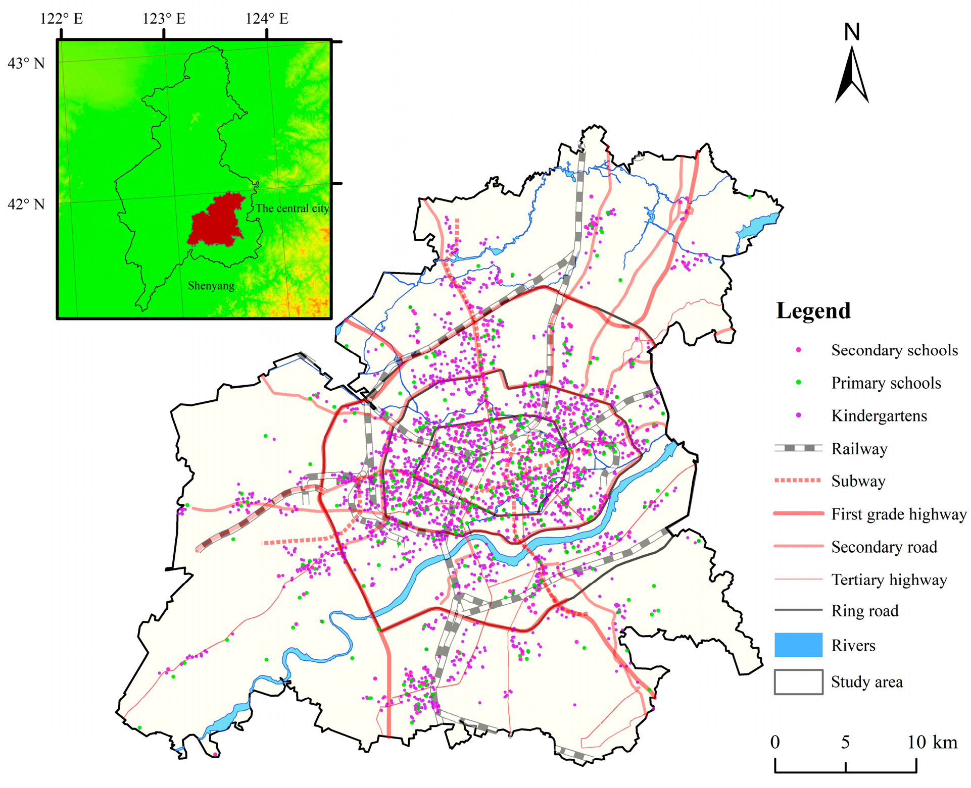
Above all, this study intends to answer four important questions: (1) What is the relationship between student density and travel-to-school distance, and what is the attraction range of basic education facilities to students in Shenyang? (2) What is the threshold of travel-to-school distance for basic education in Shenyang and what are the characteristics of the school–residence spatial structure? (3) What is the overall pattern of the travel-to-school distance for basic education in Shenyang and what are the characteristics of the leading flow direction of traveling to schools? (4) What are the school centers in Shenyang and how are the school centers distributed? Based on the above knowledge, this study uses mobile phone signaling OD data of May 2018 to explore the characteristics of travel-to-school distance and the school–residence relationship in the downtown area of Shenyang. Consequently, it can provide reference for allocation of living and studying space in Shenyang that can ensure neighborhood students can enroll in the schools.
4. Spatial Structure Characteristics of Travel-to-School
To better describe the dominant direction and volume of travel to schools in the study area, the travel-to-school flow was summarized and visualized at a grid scale of 0.5 km (
Figure 5). The number of travel-to-school links for kindergartens, primary schools, and secondary schools are 93,861, 28,191, and 20,829, and the volume is 3,583,500, 774,000, and 490,900, respectively. According to the head–tail division proposed by Jiang and Liu [
45], the number of students traveling to schools is divided into seven levels, and high-level links of travel to school are visualized to depict dominant trips. There are 620, 467, and 181 links among the corresponding research units in kindergartens, primary schools, and secondary schools from level 5 to level 7, accounting for 0.61%, 1.49%, and 0.87% of the total links, respectively. The number of students traveling to schools is 245,100, 67,100, and 31,500, accounting for 6.84%, 8.67%, and 6.41%, respectively, indicating that some trip links carry more trips, reflecting the main travel pattern of the whole region.
In order to further understand the main characteristics of traveling to schools, the first three levels are elaborated in detail. The ratios of the number of students and the links in corresponding units of kindergartens, primary, and secondary schools at level 7 are 966.68, 299.68, and 397.50, respectively. This indicates that the travel-to-school flow is relatively concentrated at this level. The 7th level travel-to-school pattern is mainly the connection between key schools and the adjacent important residential areas in the short-distance schooling area. The reason is that these are the functional center of the urban economy and culture, rich in high-quality education resources which attract a large number of students. Although a small amount of cross-regional traveling to schools is included in level 7—for example, a lot of students in Sujiatun District also attend Hunnan Four-school kindergarten and Tongxin Bilingual kindergarten in Hunnan District—the data is not as strong as the former. There are several possible reasons for the phenomenon of long-distance travel to schools across regions: Firstly, parents choose schools in or near their place of employment in order to facilitate transportation of their children. Secondly, pursuit of quality educational resources by parents or students leads to cross-regional schooling. Thirdly, separation of place of origin from the schools is also caused by living and attending schools in the current place of residence in the city center during the working day and returning to the original place of residence in the suburbs on weekends.
The ratio of the number of students and links at level 6 are 470.71, 186.82, and 227.00, respectively, and the school flow is relatively concentrated. The hierarchy is mainly composed of key schools and important residential areas within the short-distance schooling area, and between the short-distance and medium-distance schooling areas. Cross-regional school attendance increased significantly compared to level 7; for example, some students in Shenbei New District attend schools in districts where quality education resources are concentrated, such as Heping District and Shenhe District. The ratios at level 5 are 300.95, 122.66, and 135.26, respectively. Travel-to-school flow runs from short-distance schooling areas to long-distance schooling areas. It forms a small-scale intensive travel flow in the old urban areas of Heping District, Shenhe District, Dadong District, and Tiexi District, and the number of students attending schools increased from the fringe districts of Shenbei New District, Sujiatun District, and Hunnan District to the central districts. On the whole, dominant travel-to-school flow is generally inward to the short-distance schooling area, partly concentrated from the medium-distance and long-distance schooling area to the short-distance schooling area, and a small amount is the travel flow between the medium-distance and long-distance schooling areas.
The school–residence index can directly explain the flow characteristics and direction between the different schooling areas of students identified using cell phone signaling data (
Table 2), and it can better explain the characteristics of travel to school. According to the characteristics of schools and residences, most of the demand for schooling is in the short-distance and medium-distance schooling areas. The pressure of schooling in the short-distance area is greater than that for residences, while the residential pressure is greater than that of schooling in the medium-distance area. There are few students who travel to the long-distance schooling area, and those who do mainly live there. According to Formulas (2) and (3), we have calculated the travel-to-school rate of the three regions as 12.58%, 4.80%, and 5.65% of kindergartners, primary, and secondary school students who live in the short-distance schooling area. The proportion of students entering the short-distance schooling are was 33.86%, 34.53%, and 34.15%, respectively. The in-going and out-going school attendance rates in the medium-distance schooling area are similar. The out-going school attendance rate in the long-distance schooling area is much higher than the in-going rate. In addition, among the students living and studying in the short-distance and medium-distance schooling areas, the students studying in the short-distance schooling area mainly live in that area. The out-going and in-going school attendance rate in the medium-distance schooling area are both high, the number of in-coming students resident students are equal, and there is an obvious interaction between schools and residences. However, the out-going school attendance rate in the long-distance schooling area is very high and the in-going school attendance rate is very low. On the whole, the out-going school attendance rate is very low in the short-distance schooling area, while the in-going school attendance rate is very high, which shows that it ranks highest when it comes to schooling, followed by the medium-distance schooling area, and the long-distance schooling area is the weakest. Therefore, students mainly attend schools in the urban central area, but there is no attraction in the marginal area; therefore, it is imperative to improve the quality of education in the marginal area.
There are a number of study centers mainly distributed in the urban central area north of Hunhe River. The distribution of kindergartens in the school centers is relatively balanced and there are school centers in urban peripheral areas such as Shenbei New District and Sujiatun District, while primary schools and secondary schools are concentrated in the urban central area, such as Shenhe District, Heping District, Dadong District, and Tiexi District. This area represents the oldest area of urban development, with good economic conditions, dense population, complete educational facilities, and abundant educational resources. It is worth noting that Vanke Garden and Changbai on the south bank of the Hun River are important parts of the “golden corridor and silver belt” structure of Shenyang, with rich educational resources.
5. Conclusions and Discussion
5.1. Conclusions
As an important component of urban spatial structure, the school–residence spatial relationship is related to social equity, and travel between them has an important influence on urban traffic, which has a far-reaching impact on urban functionality. In this study, mobile phone signaling data was used to explore travel-to-school distance characteristics and travel-to-school spatial structure for the month of May 2018 in Shenyang. The main conclusions are as follows:
(1) Student density presents a truncated decreasing power law distribution with travel-to-school distance for basic education. At the beginning, the density of students decreases rapidly, but when the distance reaches a certain value, the decline rate tends to be gentle. When the density of students reaches 80%, the distance corresponds to the scope of schooling attraction of students. The average distance between the residence and kindergarten, primary school, and middle school in Shenyang is 5.52 km, 5.54 km, and 5.55 km respectively, which indicates that the overall level of travel is relatively low and the problem of long distance to school is quite serious.
(2) The distance threshold of travel for kindergartens is 1.30 km, and that for primary schools and secondary schools is 1.50 km. According to the threshold of distance and scope of attraction, urban school–residence spatial structure is divided into a core area, peripheral area, and marginal area. The distance increases from the core area to the marginal area, indicating obvious “short-medium-long distance” characteristics in the layout structure. The residence–school ratio decreased from the core area to the marginal area, and the residence–school spatial matching also decreased in turn.
(3) Dominant travel-to-school flow is from urban peripheral and marginal areas to the core area, and partly from marginal areas to peripheral areas. The 7th level is mainly the connection between the key schools and the important adjacent residential areas in the urban core area. The 6th level is mainly for key schools and important residential areas within the urban core area and between the urban core area and the peripheral area. The 5th level runs through the core area and marginal area. The urban core is the most attractive schooling area, while the marginal area is the least attractive.
(4) The pattern of travel-to-school is multicentered, forming a number of study centers, which are mostly concentrated in the central urban areas, such as Shenhe District, Heping District, Dadong District, and Tiexi District. These are the traditional political, economic, educational, and cultural centers, and the oldest and most mature areas of Shenyang. In addition, the study centers are mainly located north of the Hun River.
5.2. Discussion
China has already entered a new era of socialist development and the social education demand has transformed from the need for “quantity” to the pursuit of “quality”. As an important part of urban public service facilities, the uneven distribution of educational facilities is one of the influencing factors of urban residential space differentiation. In addition, educational facilities are characterized by high frequency, irreplaceability, and periodicity, which have a great influence on living and the daily commute of people. Schools provide a highly regular, almost mechanical order, with regular hours of attendance from Monday to Friday. Due to the intensive traffic flow between schools and residence, there is an impact on urban traffic during a fixed period of time every day. In addition, residential and education spaces also have an important impact on the functional layout of the surrounding land. Furthermore, they are a part of the surrounding supporting layout and influence the surrounding housing prices, while stimulating consumption and promoting economic growth. With the development of urbanization and suburbanization, urban built-up areas are expanding. The contradiction between the supply and demand of educational facilities is becoming more and more obvious, which is mainly manifested in the imbalance of space distribution of educational facilities, especially of high-quality educational resources. Therefore, solving the contradiction between supply and demand of education and optimizing the school–residence structure has become an important issue in urban planning. Data generated from mobile signaling data provides a new paradigm for researchers and planners to understand urban systems and urban spaces. The emergence of this data shifts the focus on urban planning from long-term strategic planning to short-term thinking about how cities work and are managed. It can better identify the characteristics of urban school–residence structure and provide a basis for optimization of urban spatial structure, layout of educational facilities, and road traffic planning.
According to the results of our research, the basic education facilities in Shenyang are concentrated and distributed in the central city, and the number of educational facilities in marginal areas is relatively small, especially in newly developed areas. The uneven distribution of educational facilities in Shenyang has resulted in a lot of students who live in the urban marginal area traveling to schools in the central city. In addition, the average distance between the residence and kindergarten, primary school, and middle school in Shenyang is 5.52 km, 5.54 km, and 5.55 km respectively. Therefore, to optimize the school–residence layout in Shenyang in the future, it is necessary to focus on updated planning and to improve the supporting infrastructure to guide educational facilities to agglomerate reasonably in the marginal areas. The scale of educational facilities and residential land in urban core areas needs to be effectively controlled and the construction of educational facilities in peripheral and marginal areas needs to be increased in order to achieve shorter travel distances. In view of the current spatial living and studying situation and the characteristics of travel-to-school distance, we propose the following differentiation strategies. Firstly, according to the residential distribution characteristics of students, adjust the spatial distribution of educational resources. Efforts will be made to increase investment in new urban development areas such as Hunnan District, Sujiatun District, and Shenbei New Area, and to form a spatial pattern of educational resources that is in harmony with the urban spatial structure, population concentration, distribution of school-age children, and industrial development. Secondly, promoting the adjustment of the distribution of high-quality educational resources, and the diffusion of high-quality educational resources in central areas to suburbs and remote areas through co-operation and branch schools, and promoting the equitable allocation and equalization of high-quality educational resources. Thirdly, according to the law of students’ travel-to-school distance, the service radius of educational facilities should be controlled within the threshold of the school distance. The quality of education in the border areas should be improved, attracting students from the border area to attend nearby schools. This would reduce the phenomenon of cross-regional schooling in pursuit of educational quality, thus reducing wasteful commuting costs and easing use of road traffic resources. A public transport system and public transport development policy should be implemented to alleviate traffic congestion, especially the morning and evening peak resulting from travel to and from schools.
Based on the mobile phone signaling data of Unicom users in Shenyang for the month of May 2018, this paper discussed the relationship between student density and travel-to-school distance, and obtained the attraction range and distance threshold of schooling. In addition, it discussed the relationship between living and studying, summarized the characteristics of Shenyang’s travel-to-school pattern, and put forward strategies for the improvement of the spatial distribution of living and studying. This study can be used as a reference for other cases. In future research, we will discuss the characteristics of the residence–school structure and what causes this structure, which will provide a reference for the optimization of residence–school spatial structure and promote the enrollment of students in the vicinity.


