1. Introduction
In recent years, with increased urbanization in China, different cities have been facing increased hazards of various types [
1], which can be both natural (e.g., earthquakes, tsunami, typhoon, hurricanes, etc.) and man-made (e.g., chemical leakages, terrorist attacks, etc.). Frequent urban disasters have caused huge casualties and property loss in cities and highlighted the lack of efficient strategies for disaster prevention and hazard mitigation [
2,
3]. Simultaneously, when a disaster occurs, if individuals do not have a number of security emergency shelters, together with the general public’s lack of basic knowledge of the disaster prevention safety, it is likely to lead to chaos in the social order and among the public, cause serious social unrests and losses, and endanger the public safety of cities [
4]. Emergency shelter is one of the most important tools now in disaster relief operations and it is also a concrete manifestation of humanitarian logistics, which can be used both for an immediate response and for long-term measures [
5]. Planning emergency shelters in advance is an effective approach to reducing the damage caused by disasters and ensuring the safety of residents. It is an important stage of disaster management [
6], and the scientific soundness of an emergency shelter’s location directly affects the success or failure of rescue work. In order to solve the optimal or approximate solution of other variables (e.g., transportation cost, demand, time, etc.) the basic approach is to select alternate sites first, and then utilize the conditional constraints (e.g., site area limitation, maximum facility coverage, etc.) [
7].
Much research has addressed this problem through building location models. The primary location models include
p-center model,
p-median model, location set covering model, and maximal covering location model. Hakimi first proposed the
p-median model and the
p-center model to minimize travel costs [
8]. The
p-median model is mainly used to reduce the total cost of facility configuration and the
p-center model is mainly used for minimizing the maximum distance from any demand point to the facility. Roth and Toregas first proposed the location set covering model to analyze the location problem of emergency service facilities [
9,
10], i.e., fire stations and ambulances, to ensure that all the demanding points were covered and at the same time with the smallest total number of facilities or the lowest total construction cost of the facility. Church and ReVelle put forward the maximum coverage model to determine the number of facility points with their number of facilities and coverage radius to ensure the optimal number of coverage points and maximum coverage area of each [
11].
Based on these four primary models, various location models were developed, which were extended by assigning different constraint conditions and parameters. Sweeney and Tatham divided the dynamic time into a number of specific periods, based on which, a dynamic model with profit maximization as the goal was established to solve the multi-stage dynamic location problem of a single warehouse [
12]. Alcada-Almeida et al. introduced a multi-objective location model to determine the number and location of emergency shelters and the evacuation routes that evacuees should follow [
13]. Huang et al. addressed a variation of the
p-center model with the additional assumption that a facility fails to respond to the demands from the same node, which is likely to happen to many local facilities in large-scale disasters [
14]. Considering the uncertainty of demand, Murali et al. formulated a special case of the maximal covering location model with a loss function, to account for the distance-sensitive demand, and chance constraints to address the demand uncertainty [
15]. In addition, they illustrated the use of the model in LA County. Huang et al. proposed a general fuzzy multi-objective model to solve the maximal coverage problem with distance constraints, and the solution is put forward by using a GIS-supported Ant algorithm [
16]. Zhao et al. formulated an integrated location–allocation model based on time-varying demand analysis for emergency management and applied the model in the emergency shelters planning of Shanghai [
3]. Ng et al. proposed a hybrid bi-level model that balances both behavioral assumptions to minimize the total evacuation time and the individual evacuation time [
17]. Chang and Liao proposed the location model, which uses space syntax and road-closure indices to identify where to locate emergency shelters based on behavior analysis [
18].
With more parameters considered, all models noted above have become more complicated, making them difficult to follow and apply. Although several scholars have put forward a variety of efficient algorithms, most of them are still limited in terms of theoretical development or the realization of a single case. The
p-median model,
p-center model, and coverage model are common location models with widespread applications [
9,
19]. These three models laid the foundation for the construction of the location model in our manuscript. In the selection process of urban emergency facilities, an appropriate model should be chosen according to the characteristics of the facilities. A single model cannot simultaneously meet all the problems encountered in the process of emergency facility location. Thus, given the multi-level nature of different types of emergency shelters, different models are taken into account through building multi-level location models of emergency shelters.
Since none of the mentioned models could take into consideration the capacity limitation and population imbalance distribution of emergency shelters in the process of locating, some research put forward the solution by dividing the reasonable service scope of emergency facilities based on location selected. Meng et al. [
20] and Xue [
21] considered service scope, accessibility, and travel distance in order to analyze the service scope of emergency shelters according to the location analysis model in economic geography. Kılcı et al. proposed a model based on mixed integer linear programming to select the location of temporary evacuation sites [
22]. This mathematical model considered the capacity limitations of emergency shelters while determining the location of emergency shelters. Based on the location-configuration model, Zhou et al. transformed the scope of facilities services into mathematical programming problems to maximize or minimize the optimal or feasible location [
23]. This method was essentially the same as the location model that fails to consider the scale of the site. A number of studies have differentiated the service scope based on spatial analysis performed by ArcGIS software [
23,
24,
25]. However, to the best of our knowledge, these methods are still not able to solve the issue of the scale of the emergency shelters by using the number of people to accommodate as evenly distributed, which is certainly inconsistent with real-world conditions. Therefore, the multi-level location models with the service scope analysis may provide a better approach to simulating the people’s location choice behavior in practice as well as simulating the actual service scope of each emergency shelter. In this paper, we consider these factors, thus making an important contribution to the literature.
Our article mainly focuses on small mountain cities and offers two contributions. Firstly, we put forward the multi-level location models for different grades of emergency shelters in order to minimize the travel and construction costs and to maximize the coverage rate. Secondly, the limitation of site capacity is included in the service scope of emergency shelter. In this paper, in order to define the scope of urban emergency shelter services, we developed a method that determines the service scope of each emergency shelter by weighted spatial scope. The proposed research methods and models are applied to Jianchuan, a typical small mountain city in China. This paper has provided theoretical basis and a benchmark for the optimal layout of emergency shelters in other small mountain cities.
Our article takes the spatial layout of emergency shelters in small mountainous cities as the research object. Through the three steps of location, zoning and optimization, the whole process of optimizing layout is realized through: (a) constructing a multi-level location models system suitable for different levels of emergency shelters, applying the models to the actual location selection of the emergency shelter in the Jianchuan county seat, and verifying the scientificity and effectiveness of the construction models; (b) establishing a method suitable for the service scope division of emergency shelters in small mountainous cities, and relying on GIS technology to visualize the results; (c) adjusting the location and quantity of emergency shelters in conjunction with population and urban land use within the scope of emergency shelters.
2. Description of Studied Region and Materials
China is a mountainous country with complex geological structures, where a variety of natural disasters occur. Yunnan Province is located in the Yunnan–Guizhou Plateau of Southeastern China, where 94% of the whole province area is mountains. Among 125 counties and cities located in Yunnan Province, there are only 13 cities with less than 7 degrees of fortification intensity, while there are 56 cities beyond 8 degrees. Most of these cities are located in mountainous areas. Facing the interacted pressures of both urban land restrictions and complex geological structures, layout planning for an emergency shelter system is more prominent. In view of this, this paper used Jianchuan as a case study area to explore the optimal layout of emergency shelters in mountain towns.
Located in the northwest of Yunnan Province, China (see
Figure 1), Jianchuan county is situated in the southeast of the Qinghai–Tibet Plateau and in the southern part of the Hengduan Mountains. The regional geology of this county belongs to the middle section of the three-river fold belt, which contains several fault zones. Moreover, its geological structure is complex and magmatic activities are frequent as well, thanks to its geographical proximity to the tectonic belt and its correlation with seismic activities (
Figure 1). In 2017, a total of 53,600 people lived in a 3.11-km
2 built-up area in the county seat, a small town in terms of population and land scale. Regarding its geological characteristics, although the county is located in an area of relatively flat terrain, the possibility of the occurrence of geological disasters still exists in the west and northwest of the town. In addition to the complicated geological characteristics of Jianchuan, all types of disasters have happened frequently, according to incomplete statistics (since 886 AD, in Jianchuan, 13 earthquakes occurred with a magnitude of over 5 Richter).
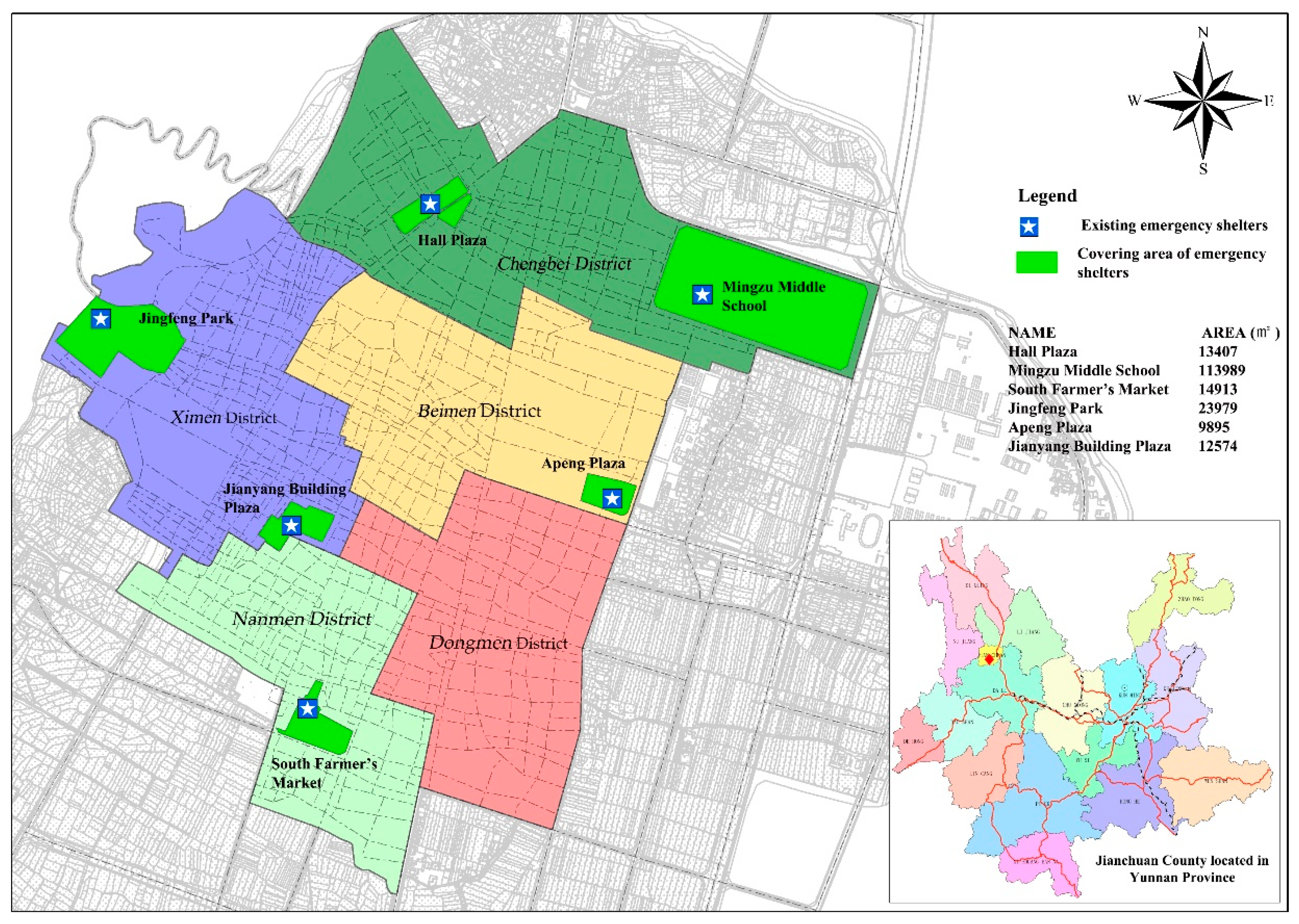
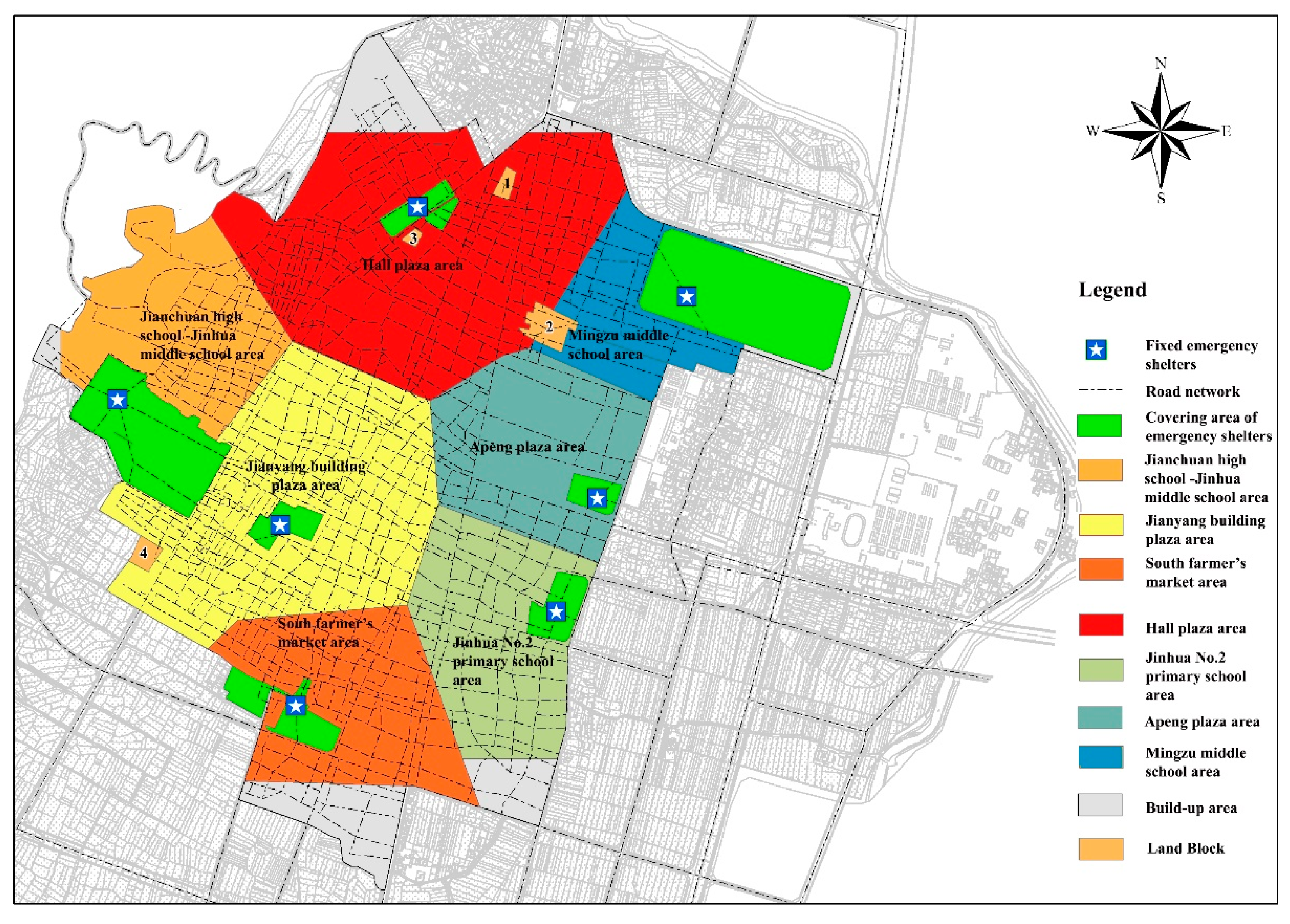
There were six existing emergency shelters in the Jianchuan county seat as of 2017 (see
Figure 1). Although the overall layout of the emergency shelter facilities in the county seat was consistent with its urban layout, challenges still exist. First, the layout of emergency shelters lacked rationality. Due to the insufficiency of urban land, most of the existing urban emergency shelters are indeed the existing parks, squares, schools, public green spaces, and so on. Consequently, it is difficult to ensure the reasonable locations of the emergency shelters. The emergency shelters in the county seat have been mainly located in the north and south of the county seat, and there is no emergency shelter in the center. Second, the scale of emergency facilities was unclear, and the system was mixed. A clear urban emergency shelter system is essential during evacuation conditions and post-disaster relief operations. However, there were no corresponding provisions on the scale of emergency shelters in the master plan of the Jianchuan county seat. Third, the allocation of emergency shelter facilities was not reasonable. Due to the tightness of land use, the existing emergency shelters are mainly configured by using existing parks, plazas, schools, and public green spaces, rather than according to the distribution of the population and the distribution of disasters. From the perspective of the distribution of disasters, the risk of landslides in the northern regions is greater due to the proximity to the mountains. In the ancient city area of the central region, the risk of fire is high because the building materials are mostly wood structures. The disaster risk in the southern region is relatively low. Moreover, the emergency shelters that have been set up are mainly concentrated in the northern and southern parts of the town, but not in the central areas. Meanwhile, the population of the Jianchuan county seat is mainly concentrated in the central and northern regions. Therefore, it is difficult to ensure the rationality of the location of emergency shelters. Furthermore, due to the particularity of urban land use, the rationality regarding the location of emergency shelters was not guaranteed.
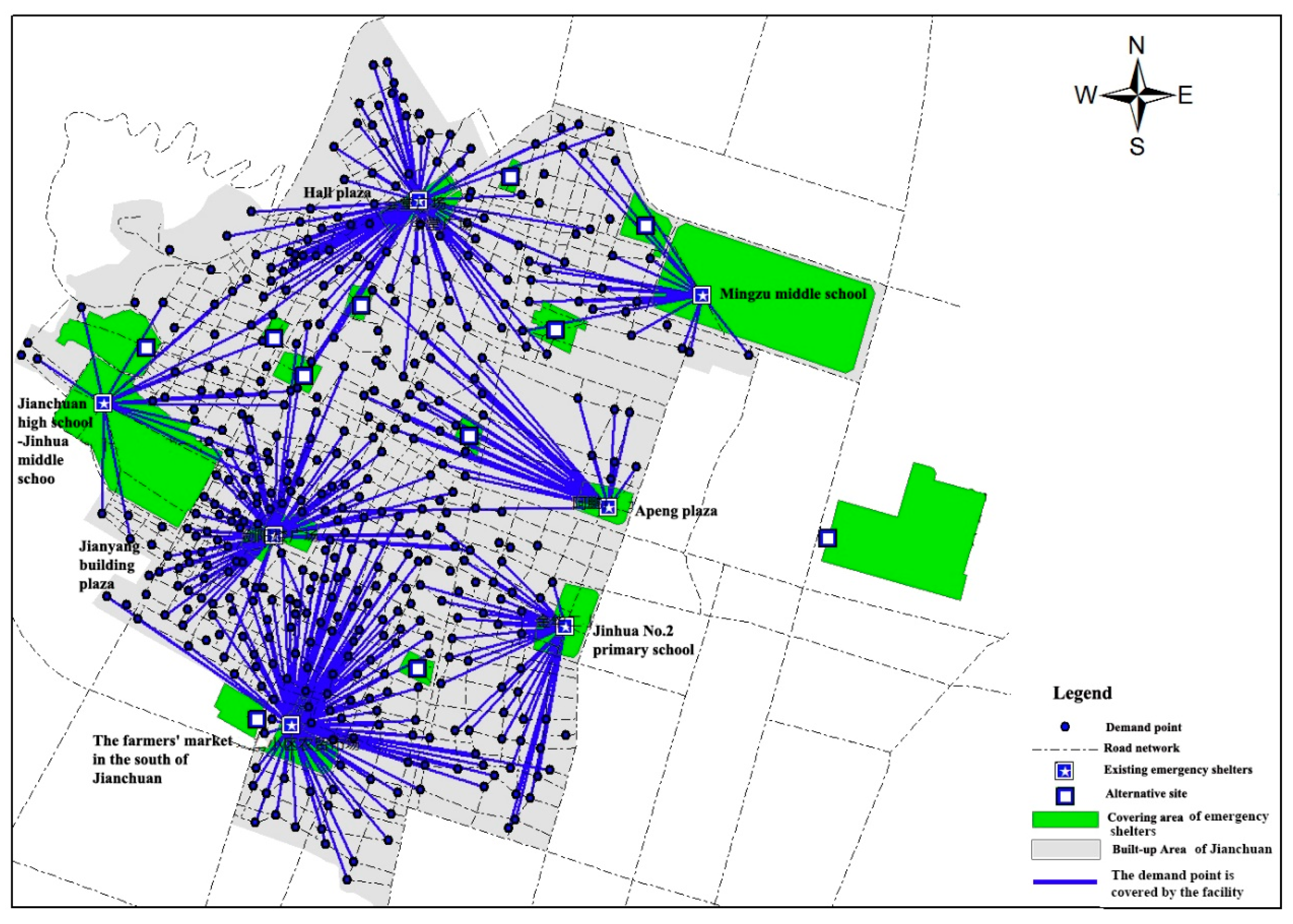
The data required for this paper mainly consist of the topographic map, the current situation of land use, the current road map, the distribution data of existing emergency shelters, and the population data of neighborhood communities in the Jianchuan county seat. Among them, the resident population data is used as demand points. The process of generating demand points involves: (1) generating a regular grid for the study area using ArcGIS software; (2) obtaining the center point of each residential area by extracting the center point of the grid; and (3) removing the demand points which are outside the construction land and on the road, and which are adjusted accordingly with the topographic map to maintain the integrity of the living area. In this manuscript, we have a total of 443 demand points. The facility points mainly come from two aspects: on the one hand, it mainly includes existing facilities. On the other hand, it mainly uses existing urban parks, plazas, school playgrounds, open spaces and other places to select a certain scale (with an area of over 0.01 km2), and its entrance and exit are connected with the main road of the city as a facility. In our paper, 18 facility points (including six existing ones) were obtained by screening.
3. Methods
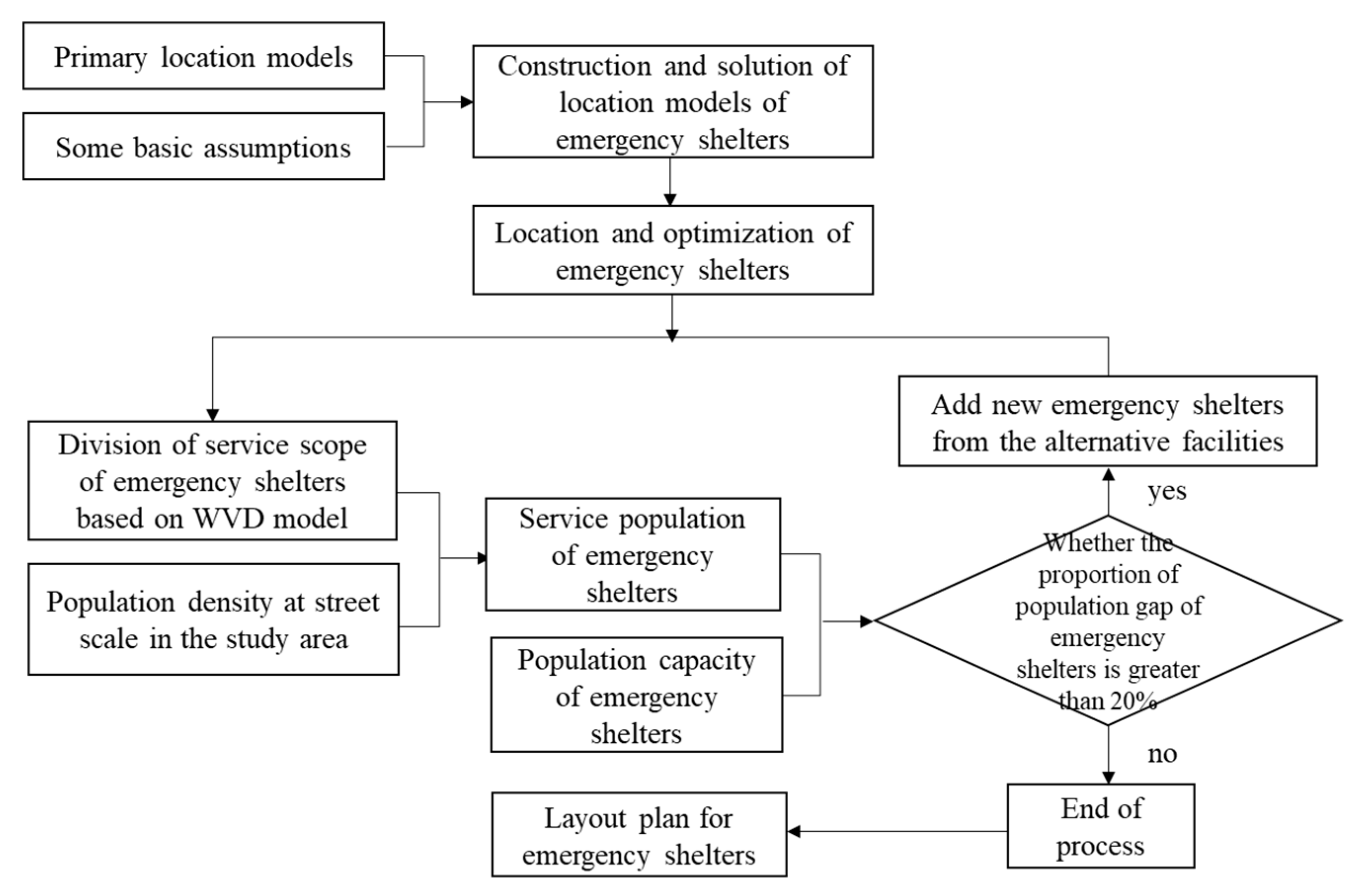
In this section, we put forward multi-level location models for different grades of emergency shelters in order to minimize the travel and construction costs and to maximize the coverage rate. Then, the actual service of emergency shelters was determined using GIS software and the Weighted Voronoi Diagram (WVD), a mathematical model that considers the limitation of site capacity. Finally, the space layout was adjusted through the combination of the actual urban land and the construction position. The corresponding models are detailed in this paper. The process of multi-level location–allocation modeling approach is illustrated in
Figure 2. The whole modeling process was divided into two parts: (1) based on the primary location models and assumptions, building multi-level location models for emergency shelters to determine the location and number of emergency shelters, (2) by dividing the service scope of the emergency evacuation site and the capacity of the analysis site itself, it was judged whether the population gap of the emergency shelter is greater than 20% [
4]. If yes, new emergency shelters need to be added; otherwise, the whole process ends. In addition, it is necessary to combine the status quo of urban land use and the construction conditions of alternative facilities to comprehensively judge and finally determine the location and quantity of emergency shelters.
Some basic assumptions for the models are:
- (a)
The locations of candidate emergency facilities and demand points are known and discrete;
- (b)
The distance between the candidate emergency facilities and demand points is known;
- (c)
If the demand point is covered by the service area of the facility, it will only be served by one facility.
- (d)
If a facility can cover 80% of the demand points around it and accommodate 80% of the population within its service scope, it is considered to be a reasonable facility [
4].
3.1. The Multi-Level Location Models for Emergency Shelters
The location of emergency shelters often considers the efficiency and fairness of the arrival of people, as well as the safety of the site. The emergency shelter is an important place to protect personal safety when a disaster occurs. The size of its service is the best embodiment of whether its spatial layout is fair or not. Therefore, the location and number of emergency shelters should be set so that all demand points are within the effective service range of the emergency shelter. That is, each demand point in the evacuation area can use the services provided by the emergency shelter in the specified travel distance. The “multi-level” refers to different levels of emergency shelters. In this paper, we classify emergency shelters into interim emergency shelters, fixed emergency shelters, and central emergency shelters. The multi-level location models mentioned in this paper refer to the location model system for different types of emergency shelters.
From the perspective of government finance, it also requires considering the economy of the layout of emergency shelters to ensure that the largest number of residents can be served with the lowest number of facilities and the lowest building costs. Considering that the scale of small cities is lower than large and medium cities, and the land limitation of small cities, in this paper, the lower limit standard for the service radius of emergency shelters is taken into account. Based on the reference standards in China, the authors attempted to set the maximum service radius of the fixed emergency shelters to 2 km, and the maximum service radius of central emergency shelters to 8 km. The specific location models are described as follows.
3.1.1. Interim Emergency Shelters
An interim emergency shelter is one of the most basic levels in the emergency evacuation system, and it is the first place for residents to take refuge when a disaster occurs. It contains great choices for interim emergency shelters, which is typically difficult to be solved through quantitative methods of location selection problems. However, it would be feasible by utilizing a variety of areas of space. Therefore, this paper mainly focuses on the analysis of fixed emergency shelters and central emergency shelters.
3.1.2. Location Model of Fixed Emergency Shelters
The location selection of a fixed emergency shelter should be based on the full coverage of the requirement points in the coverage area and minimize the total cost. The construction process of this model includes the minimum number of facilities required to cover all the requirement points in the studied area by minimizing the facility point model; on the basis of the minimum number of facilities identified, the total cost of the facility configuration is minimized by impedance settings. Specific mathematical models are expressed as follows [
8,
10].
Minimizing the facility point model (MPM)
where
D is the set of demand points.
L is the set of candidate facility points.
n is the number of demand points.
m is the number of candidate facility points.
Vi is the set of candidate service facilities for demand point
i.
r is the maximum service radius of the fixed emergency shelters and is set it to 2 km in this study.
dij is the parameter of the distance from point
i to point
j.
Equation (1) is used to minimize the number of facilities. Equation (2) ensures that each demand point i is covered by only one facility point. In this study, each facility point can be used as an emergency shelter. Equation (3) is an integer constraint of xj. Equation (4) is the set of candidate service facilities for demand point i, and the basic condition for its satisfaction is that the parameter of the distance from point i to point j is less than the effective emergency distance. Equation (5) refers to the range and condition of xj. Finally, Equation (6) is an integer constraint of Lj.
Minimized impedance model (MIM)
where
Cj is the travel cost to reach each emergency point. In this paper, we use the travel time (unit: min).
The minimized impedance model is obtained by the minimization of the facility point model. By increasing the cost of travel, the site selection of the facilities is considered efficient, while taking into account the fairness. Besides, Equation (7) demonstrates that the total travel distance of the demand points, which are covered by the emergency point, to the emergency point j is minimized.
3.1.3. Location Model of Central Emergency Shelters
The location of a central emergency shelter should maximize the coverage of the facility points when the site is selected to meet the established travel distance criteria. Based on the principles of economics, the location of such central emergency shelters should be combined with the location of a fixed emergency shelter [
11]. The maximum coverage model (MCM) is an important variant of the MPM, the basic assumptions are the same as those for the location of fixed emergency shelters. The specific mathematical models are expressed as follows.
Maximum coverage model (MCM)
where
D is the set of demand points,
n is the number of demand points,
L is the set of candidate facility points, and
m is the number of candidate facility points.
Vi is the set of candidate service facilities for demand point
i.
p is the number of service facilities planned to be established.
r is the maximum service radius of the central emergency shelters, which is set to 8 km in this paper. a
i is the demand of demand points and, in this paper, we use the coverage population to represent it.
dij is the parameter of the distance from point
i to point
j.
Equation (8) is to maximize the population of the covered demand points under limited resources. In this paper, the alternative facility points for the central emergency shelter are mainly based on the location results of the fixed emergency shelter. Equation (9) indicates that when demand point i is assigned to cover, one of the candidate facility points within its effective emergency distance must be selected as an emergency shelter. Equation (11) is the set of candidate service facilities for demand point i, and the basic condition for its satisfaction is the parameter of the distance from point i to point j is less than the effective emergency distance. Equation (12) expresses that the number of designated facilities is equal to p. Moreover, Equation (13) is the integral constraint condition of xj and yi. Equations (10), (14)–(16) refer to the range and condition of xj and yi.
3.2. The Weighted Voronoi Diagram (WVD) Model for Dividing the Service Scope of Emergency Shelters
The layout of an urban emergency shelter includes both the emergency shelter’s sites selection and their service scopes, on the basis of facility location and the actual service scope of emergency shelters. The scope of the service of emergency shelters in our manuscript refers to the range of demand points that can reach the facilities within the specified time. By coupling the distribution of the population in a city, the actual service population of each emergency shelter can be achieved, so as to solve the problem of prior site selection, which fails to consider the actual capacity of the problem.
3.2.1. The Model for Service Scope of an Urban Emergency Shelter
The service scope of urban emergency shelters is restricted and affected by nature, society, and its own foundation, representing different service scopes. Refering to the existing studies at home and abroad in relation to the characteristics of a small mountain city, in this paper, seven factors were chosen, namely, field conditions, terrain slope, type of site, traffic connectivity, the actual effective area, impact degree of a disaster, and infrastructure conditions. The score of each factor was set to 1 (extreme) to 5 (excellent). By appropriately grading these factors, we achieved the score of each influence factor on the service scope of an emergency shelter. Thus, in this study, the service scope of emergency shelters was established in addition to the impact factors to be used in evaluation system, based on Analytic Hierarchy Process (AHP), by which the weight of the seven mentioned factors can be calculated (see
Table 1).
According to the nature of the problem and the overall goal to be achieved, AHP breaks down the problem into different components and combines the factors according to the interrelated influences and affiliation of the factors to form a multi-level analytical structure model. Therefore, the problem is ultimately attributed to the determination of the relative importance of the lowest level (solutions, measures, etc., for decision making) relative to the highest level (total target) or the ranking of relative merits. The calculation process of AHP is expressed as follows:
- (1)
Establish a hierarchical structure model. The relevant factors are decomposed into several levels from top to bottom according to different attributes. The factors of the same layer are influenced by the factors of the upper layer or the factors of the upper layer, and at the same time they are dominated by the factors of the next layer or by the factors of the lower layer. The top layer is the target layer, usually only one factor, the bottom layer is usually the scheme or object layer, and there can be one or several levels in the middle, usually the criterion or indicator layer.
- (2)
Construct a judgment matrix. Starting from the second layer of the hierarchical model, for the same layer of factors belonging to each factor of the upper layer, the pairwise comparison method is used to construct a pairwise comparison matrix until the lowest layer. In this paper, we mainly compare the impact of different indicators on the service scope of emergency shelters.
- (3)
Calculate the weight vector and do a consistency check. The maximum eigenvalues and corresponding eigenvectors are calculated for each paired matrix, and consistency tests, random consistency indicators, and consistency ratios are used for consistency testing. If the test passes, the feature vector (after normalization) is the weight vector. Otherwise, it needs to be reconstructed into a pairwise comparison matrix.
- (4)
Calculate the combined weight vector and do the combined consistency test. Calculate the combined weight vector of the lowest layer to the target and perform the combined consistency test according to the formula. If the test passes, the decision can be made according to the result expressed by the combined weight vector. Otherwise, the judgment matrix needs to be reconstructed.
By running the yaahp software, we can obtain all the parameters. The value of lambda Max is 7.7376 and the consistency ratio is 0.0904 < 0.1, indicating that the obtained weight value is valid.
Affected by natural, social, and transportation conditions, different emergency shelters have different service scopes. The service scope of an emergency shelter is mainly based on its coverage radius, which is the coverage of the outside of the emergency site. Based on the weight value calculations, the weighted coverage radius and the weighted distance can be obtained according to the actual position of each emergency shelter. The calculation process is expressed as follows:
where
Ri is the weighted coverage distance of an emergency shelter.
R0 is the coverage radius of emergency shelters in various grades (i.e., 2 km for a fixed emergency shelter; 8 km for a central emergency shelter).
R1 is the radius of the emergency shelter itself,
Aj is the score of each influence factor, and
wj is the weighted value of each influence factor.
3.2.2. The Weighted Voronoi Diagram (WVD) Model for Emergency Shelter Services
The traditional methods of emergency shelter services mainly rely on subjective interpretation, dividing basically the facilities according to the street network and communities, excluding a scientific basis for the division of responsibilities. In this paper, in order to define the service scope of urban emergency shelter, we determine the coverage radius of the emergency shelters, which are used to calculate the weighted distance; next, the service scope of each emergency shelter was determined by WVD. As a special form of the location analysis model, WVD built a space adjacent model that does not depend on the coordinate geometry; its principle is spatial interaction theory, and it can be clearly expressed as a lateral adjacent relation in GIS, a better simulation of the adjacent choice in reality. In the service scope of emergency shelters, through the selection of impact factors and the determination of the weighted values, a weighted Voronoi diagram can be used to make space segmentation, thus the service scope of an emergency shelter can be divided [
26]. The specific construction model is presented as:
where
P in Equation (19) is the set of the discrete growth points on the Euclidean plane.
d(
p,
pi) and
d(
p,
pj) are the Euclidean distances between these two growth points, respectively.
wi is weight value of the growth point
pi.
Equation (20) is re-written as Equation (18), defining the weighted distance of each growth point as Euclidean distance, which is divided by the weight value. In this study, the large number of polygons produced by the important growth points has a large scope of influence. The revised model can better reflect the weights of different growth points in the spatial scope, and hence appropriate for the determination of urban emergency shelters.
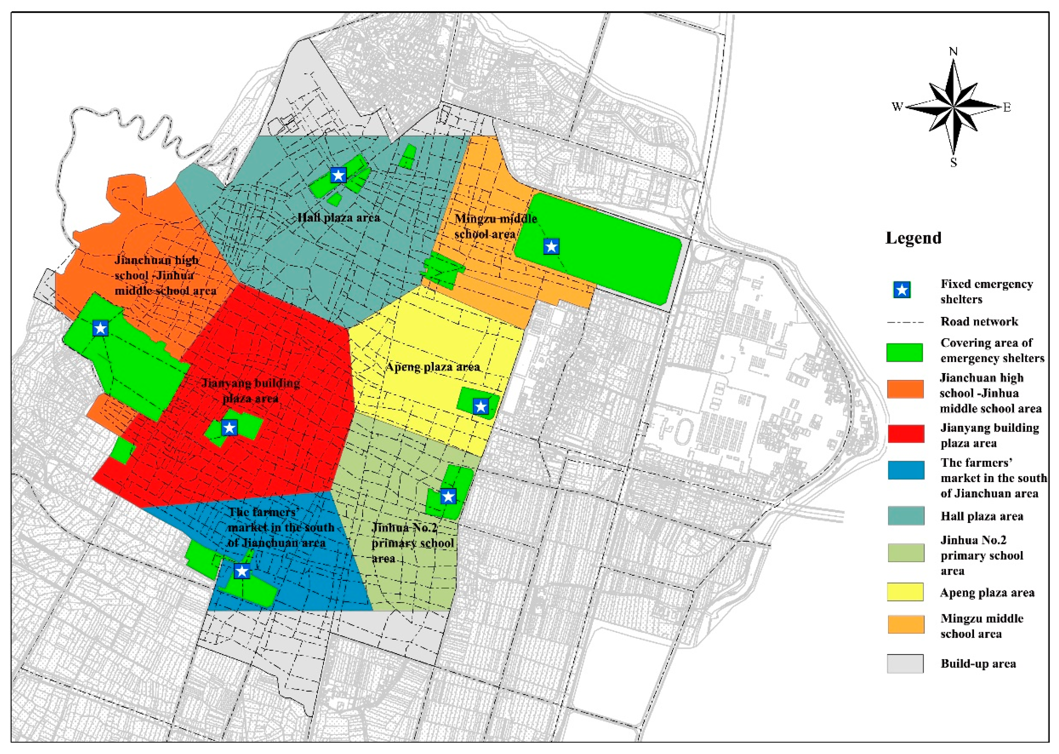
By running the Voronoi Map creation function in GIS, the service scope of each emergency shelter during the site selection stage can be obtained. Combining the actual land use situation with the population density, we can calculate the coverage rate of each emergency shelter and verify whether the location of the site is reasonable or not. The specific construction model is presented as:
where
C is the coverage rate of each emergency shelter.
P(
a) is the number of people that can be accommodated by each emergency shelter.
S1 is the effective area of each emergency shelter. Equation (22) shows the calculation process of the number of people that can be accommodated by each emergency shelter. In our manuscript, we have adopted the national unified standard (2 m
2 per person of shelter area).
P(
c) is the number of people that is within the scope of the service of each emergency shelter.
S2 is the service scope of each emergency shelter.
De is the population density of study area.
5. Conclusions
The emergency shelter is an important place to deal with emergency incidents. Moreover, it is a safe place for citizens. Facing the interacted pressures of both urban land restrictions and insufficient local finance, layout planning for an emergency shelter system is more prominent. Traditional location models cannot simultaneously meet all the problems encountered in the process of emergency facility location. Thus, in this paper, in view of multi-level of the different types of emergency shelters, different models are taken into account through building multi-level location models of emergency shelters, aiming to minimize the travel and construction costs and maximize the coverage range. For the fixed emergency shelters, we used the MPM model and the MIM model to fulfil the requirements of full coverage of the demand points in the coverage area and minimize the total cost. For the central emergency shelters, we used the MCM model to fulfil the requirements of maximizing the coverage of the facility points when the site is selected to meet the established travel distance criteria.
Regarding the capacity limitations of the location model, in this paper, we put forward a better approach for optimal layout to divide the reasonable service scope of emergency facilities and to adjust and determine the number of facilities. In order to define the scope of urban emergency shelter services, we determined the actual service of emergency shelters based on GIS software and WVD models under the limitation of site capacity and population density, and then adjusted the space layout by combining with the actual urban land and construction position. This method can be utilized to deal with the problem of the actual capacity insufficiency and an imbalanced distribution of service scope in the process of site selection of emergency shelters.
The proposed research methods and models are applied in the Jianchuan county seat, a traditional small mountain city in China, and provide theoretical guidance and model reference for location selection at emergency shelters in other small mountain cities. In practice, however, the layout of emergency shelters is also affected by several other factors. It is difficult to simulate the scope of actual service only by selecting seven factors. In addition, the distribution of population density is also affected by many factors, e.g., commuting in day-and-night and equity cost of urban resource [
27], and it is difficult to simulate the actual population distribution by dividing the population density based on the street scale as well. Moreover, based on the research performed on the layout of emergency shelters, some scenarios assume that people will be sheltered the first time after the occurrence of disasters to avoid disaster, but in the actual cases, the demand is changed over time, necessitating further studies in the future.
In the paper, we mainly discuss the location and optimization methods of emergency shelters. Planning emergency shelters is an effective approach to reducing the damage caused by disasters and ensuring the safety of residents. It is an important stage of disaster management [
6], and the scientific nature rationality of emergency shelter’s location directly affects the success or failure of rescue work. Admittedly, besides evacuation, mitigation against natural disasters by retrofitting and purchasing insurance policies is also an important strategy [
28,
29,
30], and the coordination of different stakeholders in disaster management investments is critical for the social welfare [
31]. In these aspects, we will conduct an in-depth analysis in future research, and propose corresponding countermeasures for the better implementation and construction of emergency shelter planning.


