Article

Evaluating and Planning Green Infrastructure: A Strategic Perspective for Sustainability and Resilience

by
Angioletta Voghera
and
Benedetta Giudice
*
Interuniversity Department of Regional and Urban Studies and Planning, Responsible Risk Resilience Centre, Politecnico di Torino, 10125 Torino, Italy
*
Author to whom correspondence should be addressed.
Sustainability 2019, 11(10), 2726; https://doi.org/10.3390/su11102726
Submission received: 28 March 2019 / Revised: 30 April 2019 / Accepted: 10 May 2019 / Published: 14 May 2019
(This article belongs to the Special Issue Bridging the Gap: The Measure of Urban Resilience)

Abstract

:
In the light of the current changing global scenarios, green infrastructure is obtaining increasing relevance in planning policies, especially due to its ecological, environmental and social components which contribute to pursuing sustainable and resilient planning and designing of cities and territories. The issue of green infrastructure is framed within the conceptual contexts of sustainability and resilience, which are described through the analysis of their common aspects and differences with a particular focus on planning elements. In particular, the paper uses two distinct case studies of green infrastructure as representative: the green infrastructure of the Region Languedoc-Roussillon in France and the one of the Province of Turin in Italy. The analysis of two case studies focuses on the evaluation process carried on about the social-ecological system and describes the methodologies and the social-ecological indicators used to define the green infrastructure network. We related these indicators to their possible contribution to the measurement of sustainability and resilience. The analysis of this relationship led us to outline some conclusive considerations on the complex role of the design of green infrastructure with reference to sustainability and resilience.

1. Introduction

In the context of the current changing global scenarios and overwhelming urbanization, the concepts of sustainability and resilience can help us to understand and adequately shape all the global transformations (environmental, social, energetic, climatic). These two concepts can be both read as major potential shifts in the understanding of the global territorial system and as key drivers of a more desirable future. Starting from the assumption that the two concepts have to be distinguished, we reflect on their implications in planning, design, and evaluation, with a particular focus on social, ecological and environmental issues. Since the literature on sustainability and resilience is quite extensive, we decided to select the most suitable references which attempt to conceptualize similarities and differences between sustainability and resilience. Such a focus on sustainability and resilience is necessary because there is often a common belief that “the resilience approach is a subset of sustainability science” [1] (p. 5) or is just a renewed system approach for sustainability science [2].
In particular, the focus of our research is twofold: on the one hand, we want to highlight the main similarities and differences in sustainability and resilience discourses, and on the other hand, we attempt to fill the gap between evaluation methods, measurements, and planning tools. In order to achieve these objectives, the paper analyzes some specific methodologies in the French and Italian planning frameworks which use indicators and/or multicriteria analysis as tools for designing green infrastructure (GI). We have chosen the GI strategy because it is a nature-based solution capable of enhancing the social-ecological quality of a specific territory, both in a sustainable and resilient way [3]. The methodologies and approaches will be compared in order to identify which elements of each case study fit better in the framework of the two concepts of sustainability and resilience.
The concepts of sustainability and resilience have been discussed and used in different disciplines, such as ecology, engineering, and sociology, and have been subject to multiple interpretations which cannot be interchangeable, but they can be both used to understand system dynamics and to promote strategic capabilities [4,5]. In literature, these multiple interpretations have resulted in a general fuzziness, unclearness, and malleability on the meaning of the two concepts. For instance, the malleable meaning of resilience has led to the interpretation of resilience as a “boundary object” [6] which allows a common background for different disciplines and stakeholders. This common background can enable the production of visions or consensus in decision-making and in implementation processes [7] and the creation of a common and shared communication across disciplinary borders.
In a nutshell, for our purposes, on the one hand, we can identify how the concept of sustainability is mainly referred to as a perspective issue which cities and societies attempt to reach in the face of a relevant societal transaction. In this sense, sustainability is an objective and a principle of spatial and temporal equity and “an overarching goal that includes assumptions or preferences about which system states are desirable” [2] (p. 128). On the other hand, differently from sustainability, resilience describes the system, its functionality and its behavior after a shock [8].

2. Materials and Methods

As mentioned in the previous section, the paper has a double objective: on the one hand, the analysis of sustainability and resilience, and on the other hand, the compared evaluation of GI’s indicators.
Given this as a general statement, the first step of the investigation process is a literature review on sustainability and resilience. Literature was identified by focused searches in major scientific databases (such as Scopus and Google Scholar). This analysis has its main focus in the identification of the key characteristics which compose a social-ecological system, where “social and ecological systems are deeply interconnected and co-evolving across spatial and temporal scales” [9] (p. 14). Social-ecological systems are particularly relevant nowadays in the understanding of resilience [10] and have inspired advances in sustainability science and practice [11]. In the social-ecological systems approach, where the “delineation between social and natural systems is artificial and arbitrary” [12] (p. 4), it is emphasized that “people, communities, economies, societies, cultures are embedded parts of the biosphere and shape it, from local to global scales” [13] (p. 1).
In the social-ecological context, an important strategy is the one of GI which, if provided with high multifunctionality and connectivity quality, can help to reach the objective of sustainable and resilient regions [14]. The multifunctionality of GI is intended as a necessity to “combine ecological, social and economic/abiotic, biotic and cultural functions of green spaces” [15] (p. 517) while the connectivity is represented by “the physical and functional connections between green spaces at different scales and from different perspectives” [15] (p. 517). GI is developed using different methods: for example, land-use analysis, visual interpretation, permeability studies, and multicriteria analysis. Despite the importance of considering stakeholder preferences [15] and different functionalities, there are still few studies that apply a spatial multicriteria evaluation to GI [3,16]. The majority of these methods use available territorial and environmental data (for example, Corine Land Cover data or regional database) in order to develop suitable indicators.
In the vast range of GI experimentations, we have selected two case studies: the first one is the GI developed by the French former Region of Languedoc-Roussillon (since 2015, it is part of the Occitanie Region) and the second one is the GI developed by the Italian former Province of Turin (since 2014, it has been converted into a Metropolitan City) with the contribution of the research group of Politecnico di Torino. We chose these two case studies because they are representative of two distinct European planning systems which share a long tradition in planning but have a different approach toward GI. Indeed, the two case studies represent two evaluation models based on a range of diverse social-ecological indicators. On the one hand, the Region of Languedoc-Roussillon developed its GI using a multicriteria analysis which applies indicators based on available data (homogeneous and spatially linked on the regional scale). Since the diverse resolution of available data, the regional territory has been divided into hexagonal patterns which correspond to the best compromise. The database input OCSOL (soil occupation) of the regional agency SIG-LR is available online for free and it is specifically related to the regional territory of Languedoc-Roussillon.
On the other hand, the former Province of Turin proposed a specific methodology for the identification of the ecological character of the territory and defined a set of criteria for the evaluation of different land use typologies. In this case study the data used were the ones of Corine Land Cover. Both of the two case studies have spatialized the indicators through GIS; this spatialization is useful to interpret and analyze the two methodologies in a cross-comparative perspective.
In order to fill the gap between planning and measurement in the framework of sustainability and resilience, the comparative analysis of the two methodologies is useful for the construction of a strategic GI framework through the selection of the advantages of each case study.

3. Sustainability and Resilience in Planning Debates

Many scholars have long argued on the differences which can inhabit the two concepts [4,5,17,18,19] but there is also a branch of research which highlights the possible links between the two concepts (Table 1), while considering resilience as a possible way to conceptualize sustainability by describing its typical features [20]. In other cases, resilience is described with reference to its implications on sustainability [21], for the fact that, if cities are understood as dynamic and self-organizing, the concept of sustainability has a different connotation than the original one; in this case “sustainability is challenged to build the resilience capacity of cities” [21] (p. 1203).
On the one hand, the wide literature shows how there are many definitions of resilience related to risks, climate, socio-economic, environmental and landscape changes which are taking place in the current global scenario, determining actions and transformations in the territorial system, conceived as “complex, non-linear and self-organized, permitting by uncertainty and discontinuities” [12] (p. 12). Within this framework, resilience refers to the capacity of the territorial systems and of their components to change, adapt and transform over time with or without external disturbance [22]. In particular, for our aims, we assume that one of the most prominent resilience theories has its focus on social-ecological system dynamics and interactions [10], which originates from ecological studies [23]. In this theoretical perspective, the human component must be seen as a part of nature, not separated from it. The main aspect of resilience is the ability to adapt or transform in unexpected cases of environmental and climate changes, and to transform the systems in the attempt of overcoming social-ecological limits [24]. This approach to resilience is connected to a “strong sustainability” understanding [25].
On the other hand, sustainability has become a mainstream topic since its first recognized definition of the Brundtland report “Our Common Future” [26], which focused on three pillars of sustainable development: economic, social, and environmental. This model is usually interpreted with reference to the simultaneous consideration of three main issues: economic efficiency, environmental protection, and social justice [27,28,29,30]. This model also stresses the need for integration of environmental and territorial policies for improved quality of life by relating humans to the environment. Recently, in 2015 this concept was resumed by the United Nations in setting the Sustainable Development Goals (SDGs); such a decision shows how sustainability aims at reaching certain goals which are specified in advance and can be achieved through the transformation of a system [31]. In such a perspective, sustainability can be a transformation, intended as a “radical reorganization of the social-ecological system” [17], measurable through policies and projects, while the adaptive character of a system is not always evident. In addition, it is argued that “the difference between adaptation and transformation can also be seen through time and space cross-scale interactions” [17] (p. 6). So, in some specific cases, adaptation can also include transformation, but they are not always directly linked at each scale.
With the aim of framing these concepts within the planning debate, it is essential to integrate environmental planning and management, and integration between environmental policy and spatial planning [30] and to identify the importance of a multi-level governance in order to recognize “the ubiquity of changes, the inherent uncertainties, and the potential of novelty and surprise” [32] (p. 304). In planning and design for sustainability and resilience [33], there is an evident need for a reflective capacity, linked to the recognition and management of territorial resources in order to adapt and maintain ecological and cultural diversity, maximizing environmental benefits; the flexibility of the process, that allows adaptation of decisions to the territorial needs and implementation of strategies over time [34]; the creativity that gives space to individual initiatives and to the integration with institutional practices; the inclusion of stakeholders, local actors and self-organized protagonists in the decision-making process empowering local self-reliance; the integration of different action scales and multiple policies, focus on river, rural areas, city, nature and agriculture; the robustness, the ability to converge the society toward a common evolutionary perspective, widely shared, through the guarantee of quality and effectiveness of results.
Considering the concepts of sustainability and resilience, it is possible to interpret them with reference to some of the abovementioned characteristics, which can fit both. In particular, the two concepts gather robustness [35] as an important factor for addressing social-ecological problems at different scales and levels of organization. In sustainability, robustness is related to the need to measure the persistence of a territorial system and the performance in the transformation of complex social-ecological structures. In fact, robustness is the capacity of a system to preserve its stocks and identity after a shock [35] through its reorganization and innovation abilities [36].
On the one side, robustness is a key concept while considering the preservation of a specific component of a social-ecological system (i.e., the system capital stocks including natural, human, and human-made) in the face of innovation, stress or transformation processes. On the other side, sustainability is a framework to legitimate the performance of the transformation of a system, recognizing that the functionality of the system is the precondition for economic and social development [37]. The functionality of the system depends on the quality and the persistence of the system capital stocks over time embracing inter and intra-generational equity [38].
Another common aspect is related to the specific role of biological diversity for resilience and sustainability, as a way for enhancing, for example, ecosystem quality. In biological systems, diversity must respond to the necessities of different species, which have diverse reactions towards disturbances and shocks. In this context, biological diversity (biodiversity) is furthermore essential for the self-organizing ability of complex adaptive systems [39] in terms of absorbing the disturbance and regenerating itself, but the social, the economic and the physical diversity are also effective strategies for the support of resilience. The adaptive cycle [40] is often considered to be a central metaphor in the conceptualization of the dynamics of change in social-ecological resilience. Adaptability is indeed a key aspect of resilience of social-ecological systems as it considers the interrelation between concepts of “diversity (biodiversity), redundancy (ecological variability), cycles of adaptation (multiple equilibrium states), and interaction between spatial scales (hierarchy) and temporal (activation of different times responses)” [41] (p. 780).
In social-ecological systems approach and in planning discourses, in order to enhance both sustainability and resilience, the role played by GI is highly relevant. Addressing this statement, we assume that GI can reinforce the characteristics of robustness and biological diversity of the territorial system besides fostering sustainability and resilience by increasing flexibility, redundancy, modularization and decentralization [40,42]. With reference to GI, evidence on these resilience characteristics has been mainly applied to stormwater management [21,43]; for example, a modular approach, characterized by a functional redundancy and decentralized elements, in planning and design helps to be prepared and to preplan in the event of a system’s failure [21]. GI can also contribute to perform connectivity besides functionality; connectivity is indeed a trigger of sustainable and resilient urban forms [44,45] by providing cities, from macro to micro-scale elements, with an enhanced biodiversity, improved hydrological processes and a healthier life.

4. Green (and Blue) Infrastructure in Sustainability and Resilience Discourses

GI, originally inspired by the principles of landscape ecology [46,47], has been widely recognized and promoted as the “ecological framework needed for environmental, social and economic sustainability” [48] (p. 5), thus connecting and supplying ecological, economic and social benefits which are at the basis of sustainable development; this definition of GI can indeed be considered as the first one that explicitly links GI to sustainable development. By reviewing international literature on GI, we can identify different definitions but, generally, there is a consistent presence of both natural and human-made components as essential elements. GI has firstly developed in response to different needs and, in recent years, has also influenced and entered into planning theories and policies [49] and design practices; for example, its strategic role is underlined by the European Commission, which recognized GI as a “strategically planned network of natural and semi-natural areas with other environmental features designed and managed to deliver a wide range of ecosystem services” [50]. In this context, GI can be considered as a producer of multiple benefits [15,42,51] for health and life quality. Furthermore, the concept of GI “differs from conventional approaches to open space planning because it looks at conservation values and actions in concert with land development, growth management and built infrastructure planning.” [48] (p. 5) thus including also a sustainable development perspective in addition to a preservative one. There is also increasing evidence in literature, even though not always unambiguous, that GI contributes to climate change mitigation and adaptation by supplying several benefits and services to urban environments [52,53]. With this in mind, the multifunctionality of GI can mitigate the urban heat island effect, flood risk management and ecosystem resilience [53].
The growing popularity of GI is also detectable in pioneering climate change adaptation policies of some cities, such as London, New York, Copenhagen and Paris [54,55]; these policies have indeed introduced green infrastructures in their planning and design tools for climate change adaptation and biodiversity preservation.
Since our focus is on social-ecological systems, sustainability, and resilience, we can notice (Table 2) how literature applies GI mainly to stormwater management and design even though they can contribute to provide other several benefits, such as improved air quality, urban heat island mitigation, improved communities and reduced social vulnerability, greater access to green space and increased landscape connectivity [3].
The literature review (Table 2) shows how GI can help trigger some sustainable and resilient solutions. In particular, GI can:
(1) be a flexible and adaptable answer to climate change through actions of stormwater management [21,42,52,55], improvement of soil, water and air quality [52], regulation of the urban heat island effect [53,56], and limiting of land take [57,58];
(2) enhance landscape quality by favoring landscape connectivity and fruition [3,59], supporting ecological functionality and accessibility to green space [3], and recovering degraded and vacant land [59,60,61];
(3) promote well-being in favor of a reduced social and ecological vulnerability [3] and the development of healthy communities [52,56].
In our view, GI is a strategy which combines both natural and social elements and can be conceived as a landscape network [62,63] that can enhance ecological quality through an integrated and socially inclusive approach to territories as requested by the European Landscape Convention. At the same time, it can help to overcome habitat fragmentation and promote healthy communities and, in order to be equally recognized and accessible, it must have extensive public support in policy decision-making and realization.
The project of GI needs to be based on a social-ecological evaluation of the territorial system based on index and indicators essential for the identification of quality aspects of ecosystem diversity and for the interpretation of possible pressures of human activities.
The index and indicators are used to interpret the social-ecological system with respect to the capacity of the system to preserve the ecological functionality but also to consider the impacts of human activities and the possible adaptation strategies capable of enhancing resilience and sustainability. In fact, they can measure the robustness and the persistence of a system, relating it to the capacity of maintaining their functions acting in buffer areas around the naturality core areas and in the case of withstanding shocks. They can act as interpreters of the interplay disturbance between nature and human activities, favoring a reorganization or a development of the system. By using these indicators in promoting GI, it is possible to develop an integrated social-ecological system capable of acting in a cross-scale dynamic interaction.
The spatialization of the integrated measurement of potential ecological functionality is used to evaluate the vulnerability of a territory and the loss of biodiversity, to define possible design scenarios able to contrast potential irreversible transformations and unexpected shocks. It can also be used to envision possible future directions.

5. Two Case Studies in Comparison

Towards this perspective, as mentioned in paragraph 2, we analyzed the methodologies used for the identification of two case studies of GI in France, the Region of Languedoc-Roussillon, and Italy, the Province of Turin. The two case studies, and their referring planning system, differ in some elements but the interpretation of their methodologies for GI help to demonstrate the link between the measurement of ecological functionality in terms of sustainability and resilience and the GI design.
On the one hand, the French case study is representative of a multiscale design from the national scale to the local one and it is based on a participatory multicriteria analysis of the ecological value of the territory and of the human impacts on naturality. The methodology of the Region of Languedoc-Roussillon provides a wide range of indicators for the evaluation of both ecological and social aspects of the territory. This analysis can be used to define design scenarios of the GI at a vast scale and can be redefined at the local scale, contributing to adaptation and sustainable use of territories.
On the other hand, Italy is characterized by a jeopardized approach in the different regional landscape plans and has no national disposition towards GI. Despite this national situation, some Regions and Provinces have attempted to define their own methodology for developing ecological networks, such as the Province of Turin. In this particular case the active participation of stakeholders was fundamental for the definition of connectivity scenarios. Despite the active participatory process, no social indicators were included in the process, thus leading us to state that this methodology is less comprehensive and overarching.

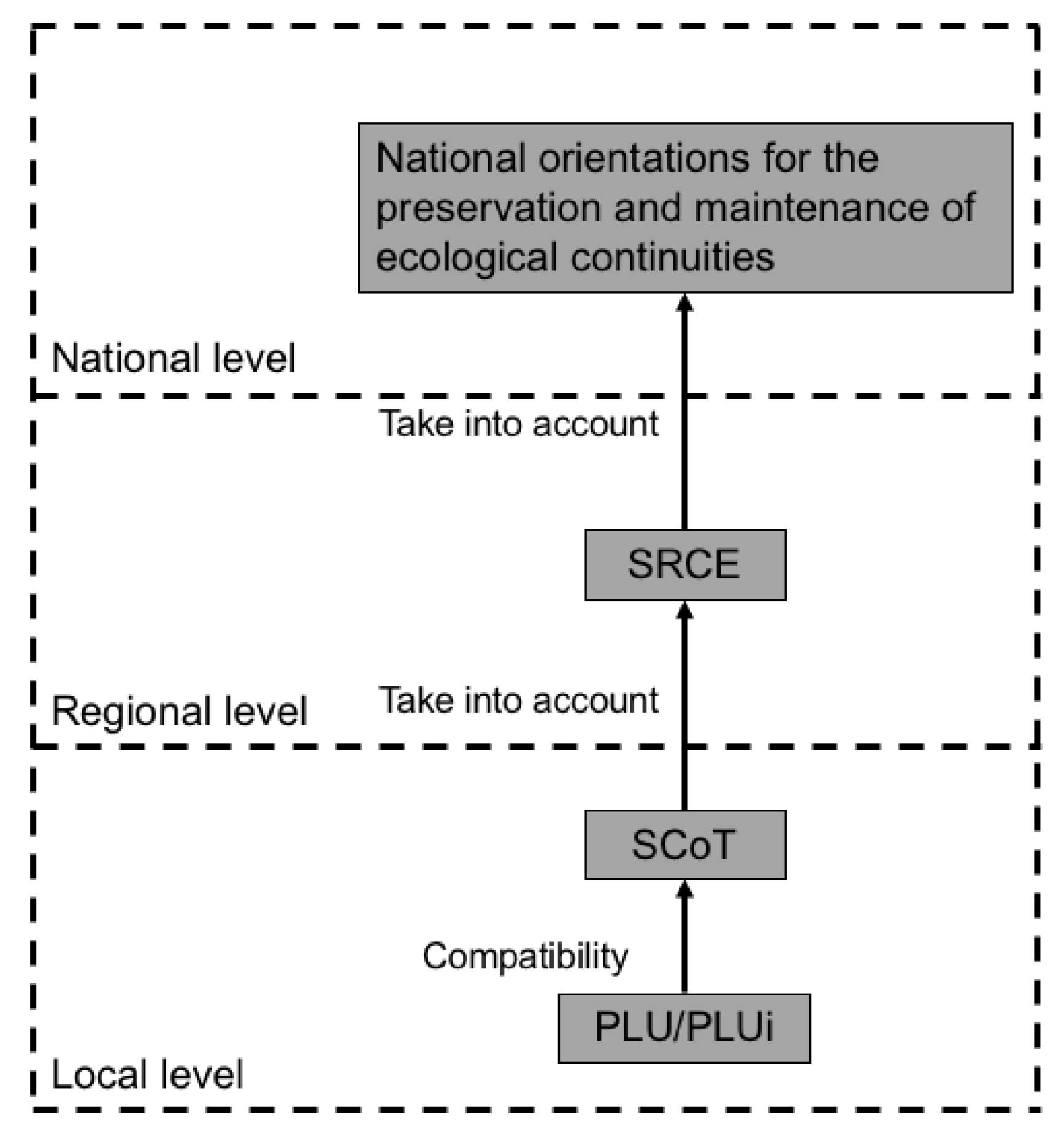
5.1. French ‘Trames Vertes et Bleues’

France in its planning system has always given great relevance to environmental and ecological elements; since 2009 this relevance has even been more strongly emphasized with the promulgation of two specific laws: the Grenelle laws I and II (the second is an extension of the first one and has been promulgated the year after, in 2010). These laws, implementing and modifying both the Code of Urbanism and the Code of Environment in line with the principles of sustainable development, can be considered as a turning point in the French planning system as they introduce new issues connected to ecological preservation.
Grenelle laws introduce a new planning tool, the Trame Verte et Bleue (TVB). It resumes the principles of landscape ecology [46,47] and shapes its characteristics in order to properly fit it into planning tools. TVB are indeed applied to different scales of planning, from the national to the local one (Figure 1). The French National State in 2014 defined and approved the “Orientations nationales pour la préservation et la remise en bon état des continuités écologiques” (National orientations for the preservation and maintenance of ecological continuities) which must be taken into account at lower scales: the regional and the local one. Regions are indeed in charge of developing a Schéma régional de cohérence écologique (SRCE), a new planning tool introduced by the Grenelle laws which must define the stakes of TVB at a regional scale.
The SRCE can appear to be juridically fragile as it has no prescriptive value (such as in the sense of granting building permits); in this sense it is neither a brake or an obstacle to land use planning but rather a functional framework for the ecological coherence of a territory and its planning tools. In this context, it gives some recommendations for raising awareness on ecological issues, for managing and protecting ecological continuities and for allowing a sustainable development and management of territories. The only legal and regulatory obligation is the necessity to be taken into account (prise en compte) by subordinate urban plans (principally Schéma de Cohérence Territoriale - SCoT). The most operational scale for a more precise specification of TVB elements is the local one, SCoT and Plan Local d’Urbanisme (PLU) or Plan Local d’Urbanisme Intercommunal (PLUi). In this context, indeed, these territories (they are often an ensemble, big or small, of municipalities) became strategic in the operational implementation of TVB for their competences in urbanism and territorial planning and projects.
TVB are composed of two main elements: biodiversity reserves and ecological corridors. In order to define and map these two elements, the National orientations document provided a methodological guide which identifies the areas that are automatically integrated in the network as biodiversity reserves or ecological corridors (for example: the core of national parks, national and regional natural reserves and spaces assigned to the conservation of specific biotopes, etc.). In order to define “extra” biodiversity reserves and ecological corridors, in addition to the ones identified by the national orientations, some Regions have identified specific methodologies, such as multicriteria analysis. The multicriteria analyses developed by some Regions (such as Aquitaine, Auvergne, Languedoc-Roussillon, etc.) have interpreted some elements of landscape ecology in the form of indicators and indices. These analyses are indeed based upon specific ecological notes, values and criteria which are applied to the single land pattern or to a network; this modeling allows us to reach a global value of functional or ecological quality of a specific territory.
Some Regions (such as Languedoc-Roussillon) have combined different indicators, not only the ones strictly connected to ecological importance but also sociological ones, linked to the presence (or absence) of human activities and their related impacts.

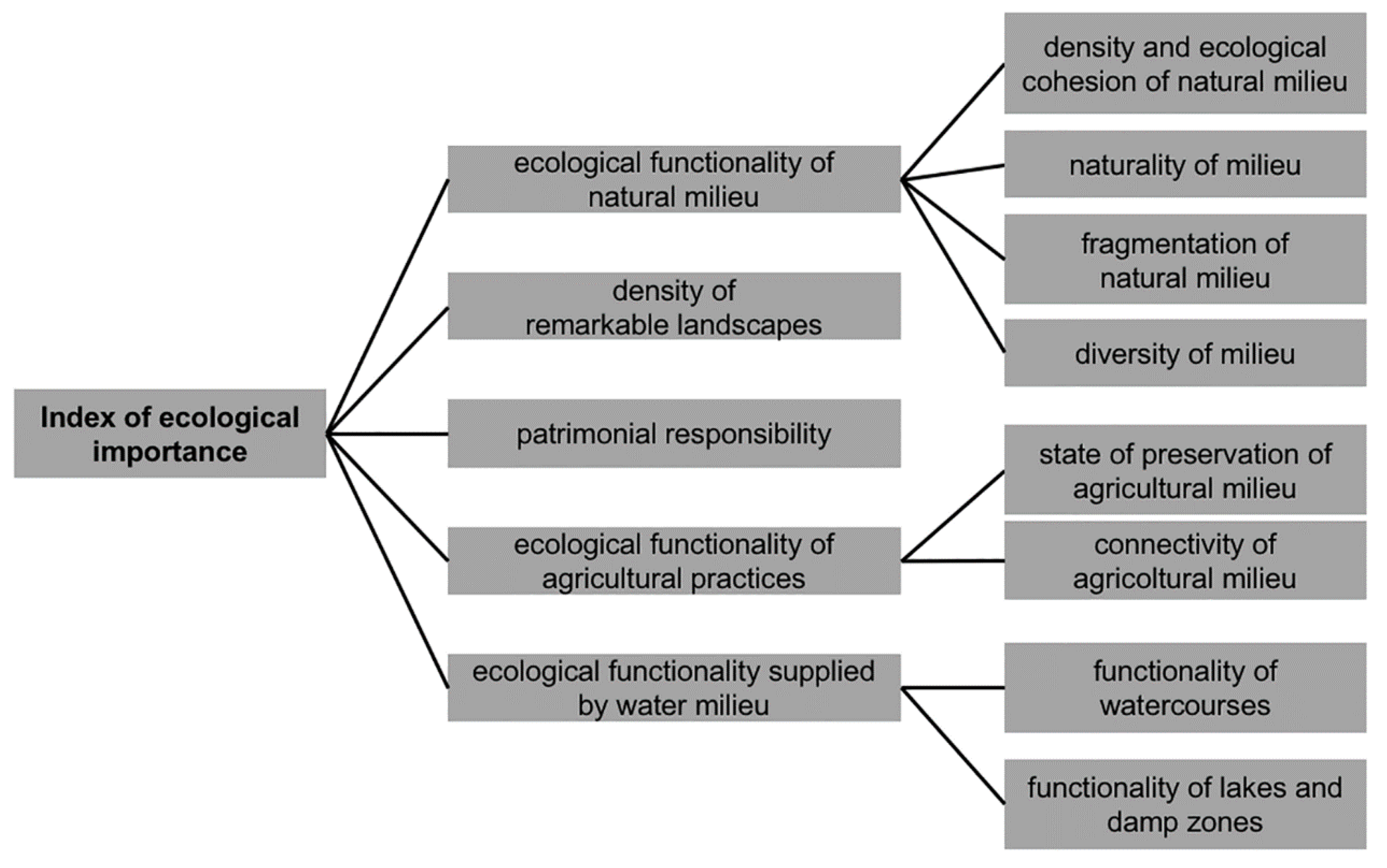
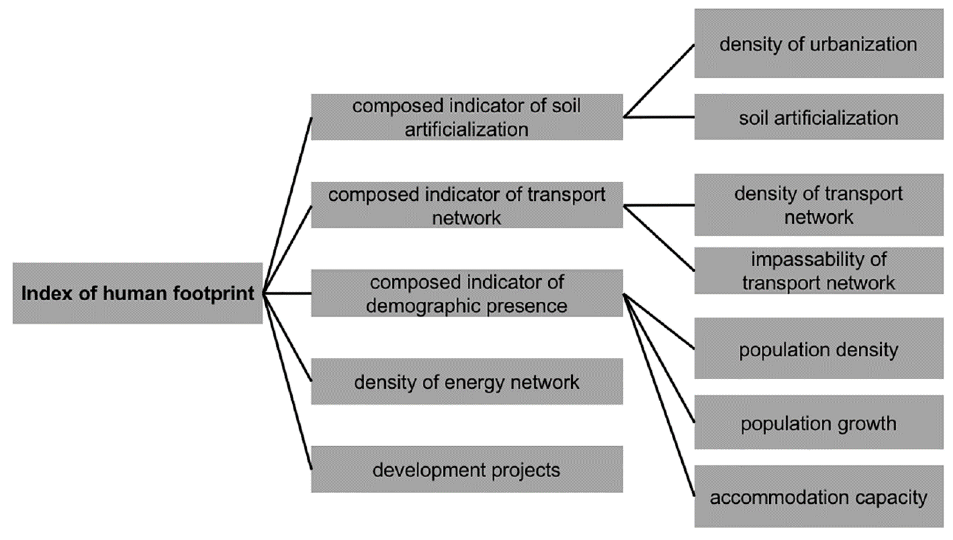
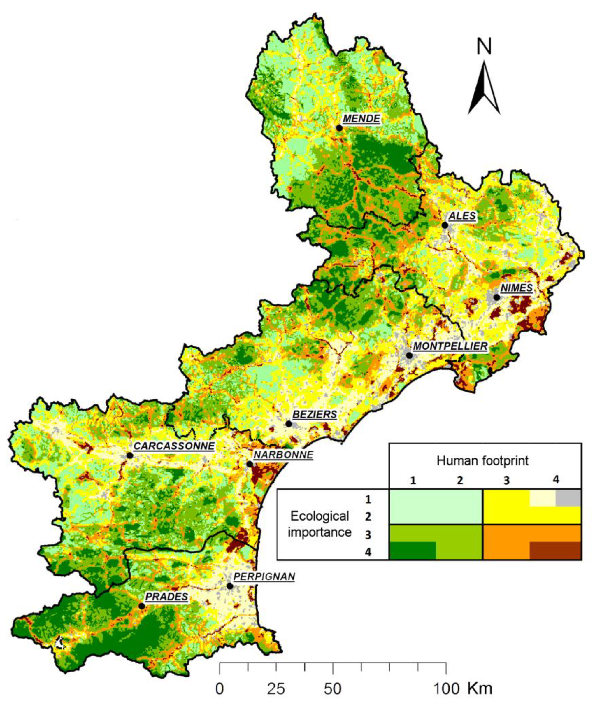
The Region of Languedoc-Roussillon, an Example of Ecological Functionality

The Region of Languedoc-Roussillon, situated in the south of France, has a high percentage, almost half of its total surface (48%), characterized as natural protected areas [64]. Despite this positive outcome, the Region is facing the process of land take and artificialization at a rate of almost 830 ha per year [64]; the most affected lands are the agricultural ones, with a loss of 51% of lands with high agronomic value between 1997 and 2009 [64].
The SRCE identifies 23 grands ensembles paysagers on the basis of their characteristics which in turn have been further detailed in 175 landscape units, thus dividing the territory into different geographical categories (such as littoral, plain areas, mountain areas, etc.).
In order to define a regional TVB, the methodological choice made by the SRCE of Languedoc-Roussillon was to qualify the ecological value of the territory by a global approach, through the identification and implementation of some indicators.
The Region of Languedoc-Roussillon in its SRCE proposed a spatialized multicriteria analysis based on the identification of a global index of potential ecological functionality of the territory, which is the result of a combination of ecological indicators (index of ecological importance) and social-ecological ones (index of human footprint).
The index of ecological importance (indice d’importance écologique) corresponds to the importance that an area is likely to have for biodiversity and ecological continuities preservation. This index is based on a spatialized multicriteria analysis which attempts to qualify the landscape mosaic. It is made up of 5 different indicators (Figure 2): ecological functionality of natural milieu, density of remarkable landscapes, patrimonial responsibility, ecological functionality connected to agricultural practices and ecological functionality of continental water milieu. These indicators show how they embrace different land uses and landscapes typologies, which are strategic for the social-ecological effectiveness of GI.
The first indicator, ecological functionality of natural milieu, gives an approximation of the ecological functionality of natural terrestrial milieu; it takes into account the surface of natural habitats and their potential inclusion in a specific protected zone, called ZNIEFF of type 2 (Zone naturelle d’intérêt écologique, faunistique et floristique). Due to the presence of different contexts (degree of naturality, differences in habitats, alteration of natural milieu by human activities and fragmentation), the indicator relies on different indicators. In a situation of a network characterized by a different natural milieu that is not so fragmented or altered by human activities, the ecological functionality is considered to be high; as a first input, since the area of natural milieu is the most relevant factor in terms of ecological functionality, it is assigned the highest weighting. In addition, the indicators concerning the diversity of the milieu (with a diverse resolution and based on categorical values) have a lower weighting in order to limit bias induced by different geometries and themes of data. The weight of naturality is furthermore reduced so as not to overestimate its importance; in identifying stakes there finally is a crossover with the global index of the human footprint.
As shown in Figure 2, the first indicator is made up by:
  • the density of the natural milieu and its ecological cohesion with ZNIEFF of type 2 (considered to be a milieu of high ecological integrity);
  • the naturality of the milieu, translating the level of human interventions or artificialization of a determined milieu. A low weighting is given to this indicator in the calculus of the indicator of the “integrity of natural milieu” in order to avoid an overestimation of the socio-economic factors related to the human footprint (it is strictly connected to factors used in the evaluation of the indicator of human footprint);
  • fragmentation of a natural milieu;
  • diversity of the milieu measures the spatial subdivision (including elevation) of different milieus which are present in a single pattern.
The second indicator expresses the density of remarkable landscapes within a parcel; different types of zoning have been included (such as cores of UNESCO sites, protection zones previously defined by law). The third indicator, the patrimonial responsibility, reports on the presence of species and/or habitats of regional, national or European interest.
The fourth indicator, the ecological functionality of agricultural practices, is based on data on land use, agricultural practices and according to experts, gives an estimation of the state of preservation and intra-network connectivity of agricultural milieu. The last indicator is connected to ecological functionality supplied by water milieu (rivers, lakes and damp zones).
The index of human footprint (indice d’empreinte humaine), aims to translate the intensity of human activities on biodiversity and, likewise the index of ecological importance, is estimated by a combination of different indicators which are weighted on the basis of supposed impacts on biodiversity preservation and ecological continuities. In this context, the index takes into account potential risks on biodiversity and ecological functionality of each single pattern. The indicators which concur with the definition of this index are: an indicator of soil artificialization, an indicator of transport networks, an indicator of demography, density of energetic network, and planning and transport projects (Figure 3).
The first indicator is a composed one which quantifies the density of urbanization and soil artificialization. The second indicator quantifies on the one hand on the density of transport network on the basis of the type of road and railway and, on the other hand, impassable obstacles (such as highways and high-speed railways) and fauna passages.
The third indicator quantifies demographic presence at a municipal level; it combines three different indicators:
  • population density, based on number of inhabitants in each municipality;
  • population growth in each municipality;
  • accommodation capacity of each pattern.
The fourth indicator reports the presence of energy production and energy transport zones which affect ecological functionality. The last indicator takes into account the perimeters of planning and transport projects, which may impact on ecological functionality.
The two global indexes of global importance and of human footprint have been distributed in four classes using the quantile method. Their intersection allows for estimating the ecological importance of each pattern of the territory in relation to human footprint. Starting from this intersection, some relevant stakes of biodiversity preservation and ecological continuities for the development of the regional TVB can be identified. The successive intersection between indicators and the ecological structure makes the overall approach more evident, also allowing a spatialization of stakes (Figure 4).
The spatialization of indicators (Figure 4) is a combined map with different gradients. On the one hand, a gradient from pale green (low ecological importance and low human footprint) to dark green (high ecological importance and low human footprint), and on the other hand, a gradient from pale green to yellow and grey (low ecological importance and strong human footprint). A third gradient goes instead from pale green to orange and brown, thus representing a gradual increase of the spatial ecological importance but also the human footprint.
This map allows us to focus the attention on the importance of avoiding two types of transitions: the transformation of green areas into brown ones can signify an increase of vulnerability of spaces relevant for biodiversity, while the transformation from brown to yellow or grey contributes to the loss of ecological importance connected to a high human footprint.
Starting from this first work, it will be possible to identify the ecological continuities useful for the full development of the regional TVB. The intersection of these ecological continuities with protected areas allows us to identify the minimum biodiversity reserves; in the sectors of high human footprint, the map enables the visualization of existing ecological continuities and the identification of areas potentially important for their maintenance and restoration. This approach aims at identifying large areas finalized to support the functioning of biodiversity at the regional scale; these areas represent the matrix which embraces biodiversity reserves, within which it is possible to identify ecological corridors, thus emphasizing the importance of the matrix in its entirety (reserves + corridors).

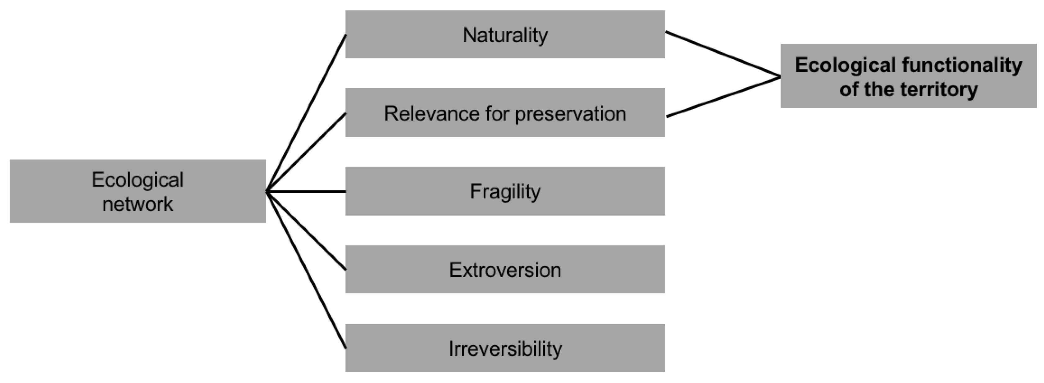
5.2. The Italian Framework of Landscape and Ecological Networks

In Italy, since the National Strategy of sustainability and biodiversity preservation in 2010 [65], the realization of ecological and landscape networks has become central in the current planning debate. Nevertheless, despite this initial boost, a national organic and shared project of landscape and ecological network in Italy is still lacking. The first attempts of designing landscape and ecological networks in the Italian planning framework come from the regional level, within the context of regional landscape plans.
Italian regional landscape plans have mainly taken on a structural interpretation of landscape following a design approach; this approach assumes as the main object of preservation the ecological value and the ecosystem service value of the entire regional landscape. Within the framework of such an approach, ecological networks help to efficiently interpret this vision. In the latest years, many regions have, indeed, drafted and/or approved their landscape plan: the Regions of Piedmont (2017), Lombardy (2017), Friuli-Venezia-Giulia (2018), Tuscany (2015), Puglia (2015) and partly Sardinia (2006). Within this context, Regions have included their reasonings on landscape and ecological networks, mostly connecting them to the topic of design.
The first approved regional landscape plan which promoted this approach is the one of the Region of Puglia with the identification of an ecological network of biodiversity, in charge of identifying all the naturality elements, and a general director scheme for the multi-purpose ecological network characterized by a design approach and a strategic significance. Also, the regional landscape plan of Tuscany entrusts a leading role to the ecological network by including it as one of the four pillars on which the plan is built.
The regional landscape plan of Piedmont, the Region in which our case study is located, identifies a network of landscape connection, a multi-purpose and multifunctional system which combines ecological elements (nodes, ecological connections, and restoration areas) with historical and cultural ones. The regional landscape plan of Friuli-Venezia-Giulia considers the regional ecological network one of the networks of strategic importance, together with those of cultural heritage and slow mobility.
The Region of Lombardy has approved a regional territorial plan with a landscape value which recognize the ecological network as a priority infrastructure of this plan, and it constitutes an indicative tool for provincial and local plans.
The developed regional ecological networks are intended for delivering a territorial project [66] in its entirety; they can help to reach an economic development and a vision of long-lasting development, which is bound to landscape preservation and valorization through the development of a landscape network that can increase the benefits and services they offer. The ecological networks of these plans identify and protect the environmental value of territories in their entirety, also in urbanized areas, overcoming the confined vision of considering them only relegated to protected areas.

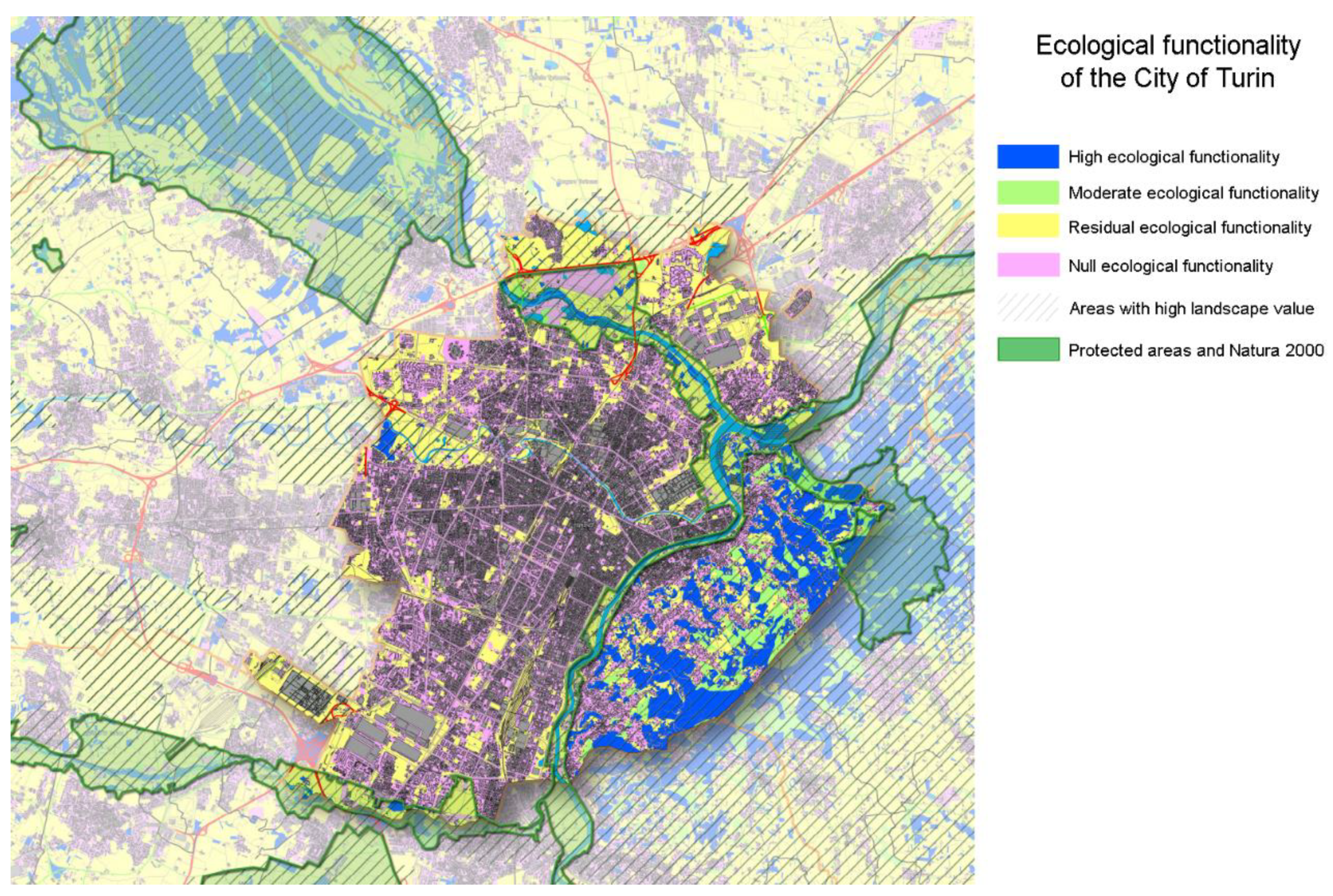
Ecological Networks in the Metropolitan City of Turin

The Metropolitan City of Turin (formerly the Province of Turin), selected as the Italian case study, is representative of a large and multifaceted conurbation, made up of more than 300 municipalities of different landscapes. Since the first Provincial Territorial Coordination Plan (PTCP) of 1999, the former Province of Turin has always carried out extensive territorial planning, with particular regard for the safeguarding of soils and the limitation of land take, by including their protection as a major objective together with the preservation of biodiversity.
With the aim of preserving biodiversity and controlling the increasing process of land take, the new PTCP, approved in 2011, has reinforced the abovementioned objectives. Later, between 2014 and 2016, the ENEA (the Italian national agency for new technologies, energy and economic sustainable development) and Politecnico di Torino [67,68], have defined the guidelines for the green system (LGSV) within which a specific methodology for the definition of the provincial ecological network (LGRE) was identified. The objective of this research is the definition of a proposal for the implementation of the provincial ecological network at the local level.
The proposed methodology promotes a bioecological approach [69,70] which identifies landscape as an interconnected system of habitats by linking areas of the Natura 2000 network (core areas, corridors and buffer zones), essential for the development of ecological functionality, and sustainable use areas and potential restoration areas. In order to define an efficient process of evaluation of both ecological functionality and environmental critical issues, it has been necessary to evaluate the different land use typologies in relation to some ecological-environmental criteria: Naturality, Relevance for preservation, Fragility, Extroversion, Irreversibility (Figure 5). They do not refer to a single land use and landscape typology, as in the French case study, but they do refer to habitats and their functionality as complex and interrelated systems.
Each ecological-environmental criterion has been attributed to each of the 97 land use typologies; the ensemble of attributed values to each land use typology characterizes them from the ecological-environmental point of view. These indicators have been further divided into different levels of specificity, varying from 5 levels (naturality and extroversion) to 3 (irreversibility).
The value of naturality, subdivided into 5 levels, is attributed to each land use typology on the basis of its proximity to the one which should be present in the absence of an anthropic disturbance (climax).
The second value, relevance for conservation, defines the level (in a scale of 4) of relevance or suitability of land uses for biodiversity preservation and considers the importance for habitat and species. It includes not only habitats of communitarian interest but also the ones whose preservation is necessary for the protection of plant and animal species of Natura 2000 network.
The classification of land uses with reference to fragility, specified on 4 levels, is carried out evaluating how much the different land use typologies are intrinsically unable of resisting to the ensemble of pressures generated by the anthropic use of the territory (such as pollution and anthropic disturbances). This indicator can be used to measure the vulnerability of a system, with reference to disaster risk, poverty, food security and climate change, within the key concepts of exposure and adaptive capacity [71]. The value of fragility principally refers to the intrinsic characteristics of a territory but, in particular for some land use typologies it is essential to evaluate the fragility which derives from the limited extension of this land use typology (for example a specific vegetal formation which characterizes a land use typology).
The level of extroversion of a land use typology depends on the intensity, probability or possibility with which that land use typology can generate pressures on neighboring areas. The value considers pressures (such as pollution, industrial production, possible diffusion of exotic species) in an integrated perspective. It is subdivided into 5 levels, ranging from the first which includes land use typologies that coincide with areas mostly occupied by human settlements to the fifth which refers to areas containing more natural typologies of land use.
The last criterion is irreversibility, which defines the level (in a scale of 3) of improbability of irreversibility in land use change which could lead to a higher degree of naturality. The first level corresponds to the most irreversible areas, as it includes sealed land use typologies (urban settlements, commercial and industrial areas).
The integrated combination of the first two indicators, naturality and relevance for conservation, has allowed us to define a territorial zoning process based upon its reticular value and its ecological functionality (Figure 6). Based on their ecological functionality, areas have been divided into four different classes: (1) areas with a high ecological functionality, (2) moderate functionality, (3) residual functionality and (4) null functionality. The first class, areas with a high ecological functionality, is optimal for the development of habitats and species; the second class, despite a lower functionality, gathers areas which are very important for reticularity. Areas with a residual functionality can be partially used for the expansion of the network. Areas included in the last class are considered as obstacles for the development of the network.
The application of this methodology to specific territories has allowed us to define a diffused reticularity for the territories involved and it contributed to making it more evident which parts of these territories are more sensitive to sudden changes caused by human activities. In fact, the methodology can be used to identify the natural areas of significant importance for the conservation of biodiversity. In addition, it also allows us to define possible areas for priority expansion of the ecological network.
Starting from their peculiar territorial context, this methodology has been further adopted and adapted to some local experimentations [67]: municipalities of Bruino, Ivrea with Bollengo, and Chieri. These experimentations were developed starting from analysis of the supra-municipal ecological system and with an active participatory process and public consultation to select the most suitable local connectivity paths. Indeed, the approach previously presented was reconsidered in each experimentation in order to guide and provide local bodies with specific measures to limit urbanization and enhance the ecological state of each territory. Each experimentation has therefore defined specific methodological and operative orientations which could be further implemented in urban plans. This implementation is eased through a simplified analysis of land use typologies which allow also to non-experts to create specific local ecological functionality maps.
The experimentation of the bioecological approach has led to the definition of a processual methodology which defines two types of action: the conservation of the structural elements of the network, which could consider implementing interventions of environmental improvement, and the design.

6. Discussion

Thus far, we have shown how the concept of GI has entered both sustainability and resilience discourses; in particular, we explored some representative case studies of GI with the objective of interpreting the role of evaluation tools for the definition of territorial sustainable and resilient scenarios. This exploration has attempted to clarify and explain how some planning elements of design, implementation and management, such as GI, can help to enhance sustainability and resilience (Table 3) at different scales (from the national to the local one).
The analyzed methods for biodiversity evaluation surely contribute to improving the ecological quality of a system, its resilience, and its adaptivity, but they also necessitate further development of specific indicators for a more precise analysis of vulnerability and of the equilibrium states of the system. We emphasize how these methods measure ecological functionality on the basis of the capacity of each habitat and buffer zones to resist and react to pressures or shocks maintaining their functions within a long period perspective.
In both cases (Table 3), indicators of ecological functionality appear to be highly relevant for reading the quality of the system. All the indicators can be associated with sustainability while not all of them can be considered as suitable indicators for measuring resilience. In order to qualitatively measure resilience, in particular social-ecological resilience, it is indeed necessary to consider more specific aspects which allow for reading the persistence of social-ecological elements of the system and its biological diversity.
Framing our analysis within the social-ecological perspective of resilience, which is about “people and nature as interdependent systems” [72], we can delineate some main differences between the two approaches led by the French case study and the Italian one. Under the GI definition, the Italian methodology has opted to develop a strictly ecological approach, with few indicators. They do not explicitly refer to a specific milieu, as occurs in the French case study, but they tend to analyze habitat functionality in a more aggregate and integrated way, as a complex system. On the other hand, the French methodology appears to be more complex as it operates in a wider spectrum, combining ecological indicators with social ones and showing itself to be capable of evaluating the impacts of human activities on the environment. Despite the apparent complexity of these indices, the French methodology allows us not only to assess the sustainability of a social-ecological system but also its resilience. Instead, the Italian methodology, since its apparent simplification in indicators and operationalization, seems to mainly address sustainability, as if it is an aggregated component of the habitat quality.
The two cases analyze two uneven territorial systems: on the one hand, the French case study considers a regional scale which must refer to a national framework of biodiversity valorization; on the other hand, the Italian case study refers to a provincial network. Despite the differences of territorial scale, an element common to the two approaches is the necessity of reaching the network project after a debate between the spatialization of the evaluation of biodiversity gradients and territorial stakeholders. In both cases, the selection of the most relevant connectivity paths for the construction of the ecological network is the result of an inclusive process in which stakeholders identify the most relevant landscape for integrity, quality and identity of each social-ecological system. Participation, in the Italian case study, is actively proposed in order to develop a sustainable approach for GI quality; in fact, GI design is the result of shared visions for the future and for the management of the territory (building consensus, promoting participation and trying to integrate self-organization initiatives for environment management and top-down approaches). Another difference lies in the fact that, as is demonstrated by the recently approved regional landscape plans, Italian networks act as multifunctional networks in support of ecological and recreational landscapes. In contrast, in France there is a relationship with the fruition and the social use of these spaces but the projects of TVB aim mainly at improving habitat quality.

7. Conclusions

Each experience has shown how a GI approach can contribute towards implementing the social-ecological quality of a territory and delivering value to sustainability and resilience. In particular, starting from the measurement of social-ecological quality of territories they are significant as they allow us to identify territorial and local stakes and delineate strategic and transversal design actions. It is difficult to decide which experience provides greater assistance towards achieving the objectives of sustainability and resilience; indeed, the choice of a proper method depends on different factors, such as data availability and precision, territorial features, and scale of analysis.
The activity of measuring ecological quality and the resilience of a system is a requirement for the construction and the selection of territories on which to attribute a transformative scenario in an integrated, reticular green system, that is a GI. GI is indeed a system which can guarantee multiple equilibria and the stability of a social-ecological system by increasing and maintaining ecosystem services. GI is also a fundamental tool for orienting towards an adaptive transformation through the selection of those territories which better fit as places of connectivity; this selection is made upon participatory processes, in both case studies, which give priority to the creation of biodiversity scenarios for the construction of a shared and desirable future. In this context, a GI project first has to be evaluative but as a second step it must be designed together with different territorial stakeholders; this approach could strongly contribute to the construction of a new, adaptive and less vulnerable cycle for territories.
With this in mind, it is important to underline how cities are increasingly giving higher importance to the role that society has to play; in particular, they are engaging on people empowerment and on the improvement of decision-making processes through the active participation of citizens in developing GI [73]. In resilience discussion, GI appears to be not just a design of systems or structures, but it is also a co-created and integrated process within complex social-ecological systems. With regard to sustainability, GI surely conveys an idea of the future based on a different ecological quality of a territory to which a dynamic fruition of the landscape has to be associated; the combined outputs can result in a weighted multi-scalar territorial choice highly anchored to the desiderata of territorial actors. Despite literature on the resilience of GI agrees that, if poorly planned, it can lead to decrease social inclusiveness [74], in our view it is fundamental to expand GI in planning mainly for their multifunctionality, for promoting diversity and for managing connectivity. It is furthermore essential to guarantee that the localization of connectivity systems is chosen through the measurement of ecological quality and functionality but also through social awareness of all possible networks, including the ones supporting the fruition of GI.
In conclusion, a sustainability and resilience strategy based on GI appears to be more adaptable not only to new and evolving territorial and societal challenges, but, as it can also be tailored to each local context, it can also provide multidimensional solutions to multidimensional challenges in cities. Additionally, we have noticed how literature on resilience is rapidly growing while there are still few studies on the linkages between urban project, urban form and resilience. In this context, a further step of the research is the shift from the measurement to the proposal of proper design and technological nature-based solutions at different scales, from the vast-scale to the lot one. These design and technological solutions can help to overcome different territorial vulnerabilities and shocks in the face of adaptation to climate change and quality of life.

Author Contributions

The article has been conceptualized, written, read and approved jointly by the two authors—A.V. and B.G.

Funding

This research received no external funding.

Conflicts of Interest

The authors declare no conflict of interest.

References

  1. Folke, C. Resilience (Republished). Ecol. Soc. 2016, 21, 44. [Google Scholar] [CrossRef]
  2. Xu, L.; Marinova, D.; Guo, X. Resilience thinking: A renewed system approach for sustainability science. Sustain. Sci. 2015, 10, 123–138. [Google Scholar] [CrossRef]
  3. Meerow, S.; Newell, J.P. Spatial planning for multifunctional green infrastructure: Growing resilience in Detroit. Landsc. Urban Plan. 2017, 159, 62–75. [Google Scholar] [CrossRef]
  4. Fiksel, J. Sustainability and resilience: Toward a systems approach. Sustain. Sci. Pract. Policy 2006, 2, 14–21. [Google Scholar] [CrossRef]
  5. Redman, C.L. Should sustainability and resilience be combined or remain distinct pursuits? Ecol. Soc. 2014, 19, 37. [Google Scholar] [CrossRef]
  6. Brand, F.S.; Jax, K. Focusing the meaning(s) of resilience: Resilience as a descriptive concept and a boundary object. Ecol. Soc. 2007, 12, 23. [Google Scholar] [CrossRef]
  7. Meerow, S.; Newell, J.; Stults, M. Defining urban resilience. Landsc. Urban Plan. 2016, 147, 38–49. [Google Scholar] [CrossRef]
  8. Derissen, S.; Quaas, M.F.; Baumgärtner, S. The relationship between resilience and sustainability of ecological-economic systems. Ecol. Econ. 2011, 70, 1121–1128. [Google Scholar] [CrossRef]
  9. Folke, C. Social–ecological systems and adaptive governance of the commons. Ecol. Res. 2007, 22, 14–15. [Google Scholar] [CrossRef]
  10. Folke, C. Resilience: The emergence of a perspective for social–ecological systems analyses. Glob. Environ. Chang. 2006, 16, 253–267. [Google Scholar] [CrossRef]
  11. Herrero-Jáuregui, C.; Arnaiz-Schmitz, C.; Reyes, M.F.; Telesnicki, M.; Agramonte, I.; Easdale, M.H.; Schmitz, M.F.; Aguiar, M.M.; Gómez-Sal, A.; Montes, C. What do We Talk about When We Talk about Social-Ecological Systems? A Literature Review. Sustainability 2018, 10, 2950. [Google Scholar] [CrossRef]
  12. Berkes, F.; Folke, C. Linking Social and Ecological Systems: Management Practices and Social Mechanisms for Building Resilience; Cambridge University Press: Cambridge, UK, 1998; ISBN 9780521785624. [Google Scholar]
  13. Folke, C.; Biggs, R.; Norström, A.V.; Reyers, B.; Rockström, J. Social-ecological resilience and biosphere-based sustainability science. Ecol. Soc. 2016, 21, 41. [Google Scholar] [CrossRef]
  14. Rusche, K.; Reimer, M.; Stichmann, R. Mapping and Assessing Green Infrastructure Connectivity in European City Regions. Sustainability 2019, 11, 1819. [Google Scholar] [CrossRef]
  15. Hansen, R.; Pauleit, S. From Multifunctionality to Multiple Ecosystem Services? A Conceptual Framework for Multifunctionality in Green Infrastructure Planning for Urban Areas. AMBIO 2014, 43, 516–529. [Google Scholar] [CrossRef] [PubMed] [Green Version]
  16. Kremer, P.; Hamstead, Z.A.; McPhearson, T. The value of urban ecosystem services in New York City: A spatially explicit multicriteria analysis of landscape scale valuation scenarios. Environ. Sci. Policy 2016, 62, 57–68. [Google Scholar] [CrossRef]
  17. Rogov, M.; Rozenblat, C. Urban Resilience Discourse Analysis: Towards a Multi-Level Approach to Cities. Sustainability 2018, 10, 4431. [Google Scholar] [CrossRef]
  18. Zhang, X.; Li, H. Urban resilience and urban sustainability: What we know and what do not know? Cities 2018, 72, 141–148. [Google Scholar] [CrossRef]
  19. Marchese, D.; Reynolds, E.; Bates, M.E.; Morgan, H.; Spierre Clark, S.; Linkov, I. Resilience and sustainability: Similarities and differences in environmental management applications. Sci. Total Environ. 2018, 613–614, 1275–1283. [Google Scholar] [CrossRef] [PubMed]
  20. Carpenter, S.; Walker, B.; Anderies, M.J.; Abel, N. From Metaphor to Measurement: Resilience of What to What? Ecosystems 2001, 4, 765–781. [Google Scholar] [CrossRef]
  21. Ahern, J. Urban landscape sustainability and resilience: The promise and challenges of integrating ecology with urban planning and design. Landsc. Ecol. 2013, 28, 1203–1212. [Google Scholar] [CrossRef]
  22. Scheffer, M. Critical Transitions in Nature and Society; Princeton University Press: Princeton, NJ, USA, 2009; ISBN 9780691122045. [Google Scholar]
  23. Holling, C.S. Resilience and stability of ecological systems. Annu. Rev. Ecol. Syst. 1973, 4, 1–23. [Google Scholar] [CrossRef]
  24. Delgado-Ramos, G.C.; Guibrunet, L. Assessing the ecological dimension of urban resilience and sustainability. Int. J. Urban Sustain. Dev. 2017, 9, 151–169. [Google Scholar] [CrossRef]
  25. Neumayer, E. Weak Versus Strong Sustainability; Edward Elgar Publishing: Northampton, MA, USA, 2003; ISBN 978-1-78100-707-5. [Google Scholar]
  26. World Commission on Environment and Development (WCED). Our Common Future; Oxford University Press: Oxford, UK, 1987. [Google Scholar]
  27. Sadler, B.; Jacobs, P. A key to tomorrow: On the relationship of environmental assessment and sustainable development. In Sustainable Development and Environmental Assessment. Perspectives on Planning for a Common Future; Jacobs, P., Sadler, B., Eds.; Canadian Environmental Assessment Research Council: Ottawa, ON, Canada, 1989; pp. 3–31. [Google Scholar]
  28. Healey, P.; Shaw, T. Planners, plans and sustainable development. Reg. Stud. 1993, 27, 769–776. [Google Scholar] [CrossRef]
  29. Campbell, S. Green cities, growing cities, just cities? Urban planning and the contradictions of sustainable development. J. Am. Plan. Assoc. 1996, 62, 296–312. [Google Scholar] [CrossRef]
  30. Briassoulis, H. Who Plans Whose Sustainability? Alternative Roles for Planners. J. Environ. Plan. Manag. 1999, 42, 889–902. [Google Scholar] [CrossRef]
  31. Olsson, P.; Galaz, V.; Boonstra, W.J. Sustainability transformations: A resilience perspective. Ecol. Soc. 2014, 19, 1. [Google Scholar] [CrossRef]
  32. Davoudi, S. Resilience: A bridging concept or a dead end? Plan. Theory Pract. 2012, 13, 299–307. [Google Scholar] [CrossRef]
  33. Voghera, A. Approaches, Tools, Methods and Experiences for Territorial and Landscape Design. In Topics and Methods for Urban and Landscape Design; Ingaramo, R., Voghera, A., Eds.; Springer: Cham, Switzerland, 2016; pp. 13–34. [Google Scholar]
  34. Pickett, S.T.A.; Cadenasso, M.L.; Grove, J.M. Resilient cities: Meaning, models, and metaphor for integrating the ecological, socio-economic, and planning realms. Landsc. Urban Plan. 2004, 69, 369–384. [Google Scholar] [CrossRef]
  35. Anderies, J.M.; Folke, C.; Walker, B.; Ostrom, E. Aligning key concepts for global change policy: Robustness, resilience, and sustainability. Ecol. Soc. 2013, 18, 8. [Google Scholar] [CrossRef]
  36. Adger, W.N.; Hughes, T.P.; Folke, C.; Carpenter, S.R.; Rockström, J. Social-ecological resilience to coastal disasters. Science 2005, 309, 1036–1039. [Google Scholar] [CrossRef]
  37. Folke, C.; Jansson, A.; Rockström, J.; Olsson, P.; Carpenter, S.R.; Chapin, F.S., III; Crépin, A.-S.; Daily, G.; Danell, K.; Ebbesson, J.; et al. Reconnecting to the biosphere. AMBIO 2011, 40, 719–738. [Google Scholar] [CrossRef] [PubMed]
  38. Finco, A.; Nijkamp, P. Pathway to urban sustainability. J. Environ. Policy Plan. 2001, 3, 289–309. [Google Scholar] [CrossRef]
  39. Levin, S. A Fragile Dominion: Complexity and the Commons; Perseus Books: Cambridge, MA, USA, 1999; ISBN 0-7382-0111-1. [Google Scholar]
  40. Wilkinson, C. Social-ecological resilience: Insights and issues for planning theory. Plan. Theory 2011, 11, 148–169. [Google Scholar] [CrossRef]
  41. De Lotto, R.; Esopi, G.; Sturla, S. Sustainable policies to improve urban ecosystem resilience. Int. J. Sustain. Dev. Plan. 2017, 12, 780–788. [Google Scholar] [CrossRef]
  42. Ahern, J. From fail-safe to safe-to-fail: Sustainability and resilience in the new urban world. Landsc. Urban Plan. 2011, 100, 341–343. [Google Scholar] [CrossRef] [Green Version]
  43. Newell, J.P.; Seymour, M.; Yee, T.; Renteria, J.; Longcore, T.; Wolch, J.R.; Shishkovsky, A. Green Alley Programs: Planning for a sustainable urban infrastructure? Cities 2013, 31, 144–155. [Google Scholar] [CrossRef]
  44. Sharifi, A. Resilient urban forms: A macro-scale analysis. Cities 2019, 85, 1–14. [Google Scholar] [CrossRef]
  45. Sharifi, A.; Yamagata, Y. Resilient Urban Form: A Conceptual Framework. In Resilience-Oriented Urban Planning; Yamagata, Y., Sharifi, A., Eds.; Springer: Cham, Switzerland, 2018; pp. 167–179. ISBN 978-3-319-75797-1. [Google Scholar]
  46. Burel, F.; Baudry, J. Écologie du Paysage. Concepts, Méthodes et Applications; Éditions TEC&DOC: Paris, France, 1999; ISBN 2-7430-0305-7. [Google Scholar]
  47. Clergeau, P. Une Écologie du Paysage Urbain; Éditions Apogée: Rennes, France, 2007; ISBN 9782843982880. [Google Scholar]
  48. Benedict, M.A.; McMahon, E.T. Green Infrastructure: Smart Conservation for the 21st Century; Sprawl Watch Clearing House: Washington, DC, USA, 2002; Available online: http://www.sprawlwatch.org/greeninfrastructure.pdf (assessed on 18 March 2019).
  49. Lennon, M. Green infrastructure and planning policy: A critical assessment. Local Environ. 2015, 20, 957–980. [Google Scholar] [CrossRef]
  50. European Commission (EC). Communication from the Commission to the European Parliament, The Council, the European Economic and Social Committee and the Committee of the Regions. Green Infrastructure (GI)—Enhancing Europe’s Natural Capital, COM (2013) 249 Final; European Commission: Brussels, Belgium, 2013. [Google Scholar]
  51. Lovell, S.T.; Taylor, J.R. Supplying urban ecosystem services through multifunctional green infrastructure in the United States. Landsc. Ecol. 2013, 28, 1447–1463. [Google Scholar] [CrossRef]
  52. Demuzere, M.; Orru, K.; Heidrich, O.; Olazabal, E.; Geneletti, D.; Orru, H.; Bhave, A.G.; Mittal, N.; Feliu, E.; Faehnle, M. Mitigating and adapting to climate change: Multi-functional and multi-scale assessment of green urban infrastructure. J. Environ. Manag. 2014, 146, 107–115. [Google Scholar] [CrossRef]
  53. Sussams, L.W.; Sheate, W.R.; Eales, R.P. Green infrastructure as a climate change adaptation policy intervention: Muddying the waters or clearing a path to a more secure future? J. Environ. Manag. 2015, 147, 184–193. [Google Scholar] [CrossRef] [Green Version]
  54. Boyle, C.; Babarenda Gamage, G.; Burns, B.; Fassman-Beck, E.; Knight-Lenihan, S.; Schwendenmann, L.; Thresher, W. Greening Cities. A Review of Green Infrastructure; Transforming Cities: Innovations for Sustainable Futures; University of Auckland: Auckland, New Zealand, 2014; ISBN 978-0-9922510-2-4. [Google Scholar]
  55. Mell, I. Global Green Infrastructure: Lessons for Successful Policy-Making, Investment and Management; Routledge: New York, NY, USA, 2016; ISBN 978-1-13-885464-2. [Google Scholar]
  56. Tzoulas, K.; Korpela, K.; Venn, S.; Yli-Pelkonen, V.; Kazmierczak, A.; Niemela, J.; James, P. Promoting ecosystem and human health in urban areas using Green Infrastructure: A literature review. Landsc. Urban Plan. 2007, 81, 167–178. [Google Scholar] [CrossRef] [Green Version]
  57. Artmann, M. Urban gray vs. urban green vs. soil protection—Development of a systemic solution to soil sealing management on the example of Germany. Environ. Impact Assess. 2016, 59, 27–42. [Google Scholar] [CrossRef]
  58. Artmann, M.; Kohlera, M.; Meinela, G.; Ganb, J.; Iojac, I.C. How smart growth and green infrastructure can mutually support each other—A conceptual framework for compact and green cities. Ecol. Indic. 2019, 96, 10–22. [Google Scholar] [CrossRef]
  59. Zhang, Z.; Meerow, S.; Newell, J.P.; Lindquist, M. Enhancing landscape connectivity through multifunctional green infrastructure corridor modeling and design. Urban For. Urban Green. 2019, 38, 305–317. [Google Scholar] [CrossRef]
  60. Nassauer, J.I.; Raskin, J. Urban vacancy and land use legacies: A frontier for urban ecological research, design, and planning. Landsc. Urban Plan. 2014, 125, 245–253. [Google Scholar] [CrossRef]
  61. Pallagst, K.; Fleschurz, R.; Trapp, F. Greening the shrinking city—policies and planning approaches in the USA with the example of Flint, Michigan. Landsc. Res. 2017, 42, 716–727. [Google Scholar] [CrossRef]
  62. van Langevelde, F.; van der Knaap, W.G.M.; Claassen, G.D.H. Comparing Connectivity in Landscape Networks. Environ. Plan. B 1998, 25, 849–863. [Google Scholar] [CrossRef]
  63. Voghera, A. Land Use Indicators for Landscape Assessment. In Landscape Indicators. Assessing and Monitoring Landscape Quality; Cassatella, C., Peano, A., Eds.; Springer: Dordrecht, The Netherlands, 2011; pp. 141–166. ISBN 978-94-007-0365-0. [Google Scholar]
  64. Schéma Régional de Cohérence Écologique (SRCE) de Languedoc-Roussillon, Enjeux Relatifs Aux espaces importants Pour la Biodiversité et Pour Les Continuités Écologiques. 2013. Available online: http://www.occitanie.developpement-durable.gouv.fr/IMG/pdf/1_SrceLrDiagV3partie1Enquete_publique_cle2f6f31.pdf (accessed on 15 April 2019).
  65. Ministero Dell’ambiente e Della Tutela Del Territorio e Del Mare (MATTM). Strategia Nazionale Per la Biodiversità in Italia; DPN: Roma, Italy, 2010.
  66. Magnaghi, A. Il Progetto Locale. Verso la Coscienza di Luogo; Bollati Boringhieri Editore: Torino, Italy, 2010; ISBN 9788833921501. [Google Scholar]
  67. Voghera, A.; Negrini, G.; La Riccia, L.; Guarini, S. Reti ecologiche nella pianificazione locale: Esperienze nella Regione Piemonte. Reticula 2017, 14, 1–9. [Google Scholar]
  68. Voghera, A.; La Riccia, L. Ecological Networks in Urban Planning: Between Theoretical Approaches and Operational Measures. In New Metropolitan Perspectives. Local Knowledge and Innovation Dynamics Towards Territory Attractiveness Through the Implementation of Horizon/E2020/Agenda2030; Calabrò, F., Della Spina, L., Bevilacqua, C., Eds.; Springer: Cham, Switzerland, 2018; Volume 2, pp. 672–680. ISBN 978-3-319-92101-3. [Google Scholar]
  69. Bennett, G.; Wit, P. The Development and Application of Ecological Networks. A Review of Proposals, Plans and Programmes; AID Environment: Amsterdam, The Netherlands, 2001; Available online: https://portals.iucn.org/library/sites/library/files/documents/2001-042.pdf (accessed on 20 March 2019).
  70. Todaro, V. Reti Ecologiche e Governo Del Territorio; FrancoAngeli: Milano, Italy, 2010; ISBN 9788856825008. [Google Scholar]
  71. Miller, F.; Osbahr, H.; Boyd, E.; Thomalla, F.; Bharwani, S.; Ziervogel, G.; Walker, B.; Birkmann, J.; van der Leeuw, S.; Rockström, J.; et al. Resilience and Vulnerability: Complementary or Conflicting Concepts? Ecol. Soc. 2010, 15, 11. Available online: http://www.ecologyandsociety.org/vol15/iss3/art11/ (accessed on 25 March 2019). [CrossRef]
  72. Folke, C.; Carpenter, S.R.; Walker, B.; Scheffer, M.; Chapin, T.; Rockström, J. Resilience thinking: Integrating resilience, adaptability and transformability. Ecol. Soc. 2010, 15, 20. Available online: http://www.ecologyandsociety.org/vol15/iss4/art20/ (accessed on 25 March 2019). [CrossRef]
  73. Wilker, J.; Rusche, K.; Rymsa-Fitschen, C. Improving Participation in Green Infrastructure Planning. Plan. Pract. Res. 2016, 31, 229–249. [Google Scholar] [CrossRef]
  74. Haase, D.; Kabisch, S.; Haase, A.; Andersson, E.; Banzhaf, E.; Baró, F.; Brenck, M.; Fischer, L.K.; Frantzeskaki, N.; Kabisch, N.; et al. Greening cities—To be socially inclusive? About the alleged paradox of society and ecology in cities. Habitat Int. 2017, 64, 41–48. [Google Scholar] [CrossRef]
Figure 1. The structure of TVB at different levels.
Sustainability 11 02726 g001
Figure 2. The index of ecological importance and its indicators.
Sustainability 11 02726 g002
Figure 3. The index of the human footprint and its indicators.
Sustainability 11 02726 g003
Figure 4. Map of intersection of ecological and social indicators (source: adapted from SRCE Languedoc-Roussillon).
Sustainability 11 02726 g004
Figure 5. Indicators of the provincial ecological network of Turin.
Sustainability 11 02726 g005
Figure 6. Ecological functionality of the city of Turin (source: adapted from PTC2 Torino).
Sustainability 11 02726 g006
Table 1. Features of sustainability science approach and resilience approach.
Sustainability Science ApproachResilience Approach
PeculiaritiesOverarching goal for social justice, environmental protection and economic efficiency
Radical reorganization of the social-ecological system
Capacity to change, adapt and transform over time with or without disturbances
Overcome social-ecological limits
Common elementsIntegrate environmental and planning management
Need of a reflective capacity
Need of flexibility of the process
Inclusion of stakeholders
Robustness
Biological diversity
Table 2. Sustainable and resilient solutions of GI.
ResilienceSustainabilityReferences
Governing climate changeManaging and regulating stormwater hazardsx[21,42,52,55]
Improving soil, air and water qualityx[52]
Regulating urban heat island effectxx[53,56]
Limiting land take and soil sealingx[57,58]
Enhancing landscape qualitySupporting landscape connectivity and fruition (slow mobility)x[3,59]
Supporting ecological functionality and accessibility to green spacexx[3]
Recovery of degraded and vacant landx[59,60,61]
Promoting well-beingReducing social and ecological vulnerabilityxx[3]
Developing healthy communitiesxx[52,56]
Table 3. French and Italian indicators and their relationships with sustainability and resilience.
ResilienceSustainability
French indicatorsIndex of ecological importanceecological functionality of natural milieuxx
density of remarkable landscapesxx
patrimonial responsibilityx
ecological functionality of agricultural practicesxx
ecological functionality supplied by water milieuxx
Index of human footprintcomposed indicator of soil artificializationxx
composed indicator of transport networkx
composed indicator of demographic presencepartiallyx
density of energy networkx
development projectsx
Italian indicatorsnaturalityxx
relevance for preservationxx
fragilityxx
extroversionx
irreversibilityx

