1. Introduction
Geodiversity plays an important role in the characteristics and evolution of the landscape as well as in the configuration and sustenance of ecosystems. This study of geological heritage, considered as the most valuable aspect of geodiversity, is based on the compilation of inventories of sufficient size, which identify places of interest, help analyze their conservation problems and ways to act accordingly, allow their didactic and informative potential to be harnessed and disseminated, and assist in the definition of strategies, action plans, and conservation [
1,
2,
3,
4].
The concepts of geological heritage and geodiversity have traditionally been used very rarely and, therefore, have had little consideration in comparison with the concept of biodiversity, which is much more widespread and has been the basis of the criteria followed to declare Protected Spaces or considered as are the elements of natural heritage [
5,
6]. In Spain, in recent years, legislation has significantly reinforced the concepts of geological heritage and geodiversity by including Geological Interest Places in the Spanish Inventory of Natural Heritage and Biodiversity. Geological heritage has a natural intrinsic value with a social, scientific, and landscape significance, which are concepts that are jointly involved in the management of the territory [
7,
8,
9,
10].
Since 2000, a new denomination was developed, with great success, for cases when there is a great abundance of relevant geological elements in a region—namely, “geopark.” Officially recognized by UNESCO in 2015, geoparks are understood as territories that harbor unique geological forms of special scientific importance, singularity, or beauty, which are representative of the evolution of geological history and of the events and processes that have formed their exclusive characteristics, without having to ignore their ecological, cultural, or archaeological aspects related to geology [
3,
4]. Geoparks seek the promotion of geological heritage and sustainable development together. Considering that geological features are witnesses of the evolution of the Earth, their conservation is a priority in order to be able to study, investigate, analyze, and interpret all the processes of the history of the planet. Additionally, the geological heritage can become more than a scientific and educational resource. It is also attracting growing interest as an economic resource in sustainable development strategies in natural parks through geotourism [
11,
12,
13,
14,
15,
16].
Today, new technologies allow the creation of different databases, using “virtual globes” such as the Google Earth computer program, and, in other geomatic applications, with devices running the Android mobile operating system [
11] for personal use (smartphones, tablets, personal digital assistants (PDAs), “smart TVs”, etc.) in which different layers of geological information constitute geological resources that are used in real-time for different scientific and didactic uses. The purpose of such applications is to take advantage of new technologies to enhance the value of geodiversity through a virtual geological itinerary [
17,
18,
19] with a series of geosites mapped and georeferenced with Geographical Information Systems and transformed into Keyhole Markup Language (KML). This allows the sites to be loaded in virtual globes, which allows the visualization and manipulation of layers [
20,
21], at different scales, to interact with other digital cartographic layers (geological, topographic, slopes, digital elevation model, multitemporal remote sensing, etc.). In addition, this allows the spatial distribution of the different sites in the geological context to be analyzed as well as the planning of itineraries. Using KML to superimpose digital objects on the 3D views of Google Earth facilitates the understanding of certain geological structures (anticlines, synclines, and faults) as well as the geolocation of the different lithologies and their outcrops, which can be made to stand out much better than on traditional maps, and to which descriptive information about the geosites and virtual flights can be added [
22,
23,
24,
25].
The purpose of this study is to identify, assess, and generate virtual itineraries of the most significant geological/geomorphological sites of a group of more than 100 natural areas of the provinces of Salamanca, Ávila, and Cáceres (West of Spain). The areas investigated in this study were selected for a geotouristic appeal that complements Spain’s rich historical and cultural heritage. A database of key locations was subsequently generated, which is also used to promote geoconservation.
The area studied is sufficiently large for its sustainable development to be enhanced through tourism, and could be a good candidate for becoming a geopark. The proposed name of this potential park is "Geopark of the three mountain ranges and the three rivers of Salamanca", in reference to the Sierras (mountain ranges) of Béjar, Gata, and Francia-Quilamas, and to the Duero, Tormes, and Águeda rivers [
26,
27,
28,
29,
30]. A geopark is not a protected natural space since this denomination does not entail the generic protection of the territory nor a regulation of uses. However, it is required to defend the values of the conservation of the geological heritage, the destruction of which is not tolerated. This integrates very well with the concept of a natural area. To be a UNESCO Geopark, it is very important to indicate whether the selected geosites have an international interest. The obligatory reference for Spain is the "Global Gesosites" project carried out by the IGME (
http://www.igme.es/patrimonio/GEOSITES/publication.htm) [
31]. All of studied geosites are located in the central area of the framework “Iberian Variscan orogeny,” and the geosites 10 to 13 belong to the Spanish Global Geosite 194.
Geological and Geomorphological Context
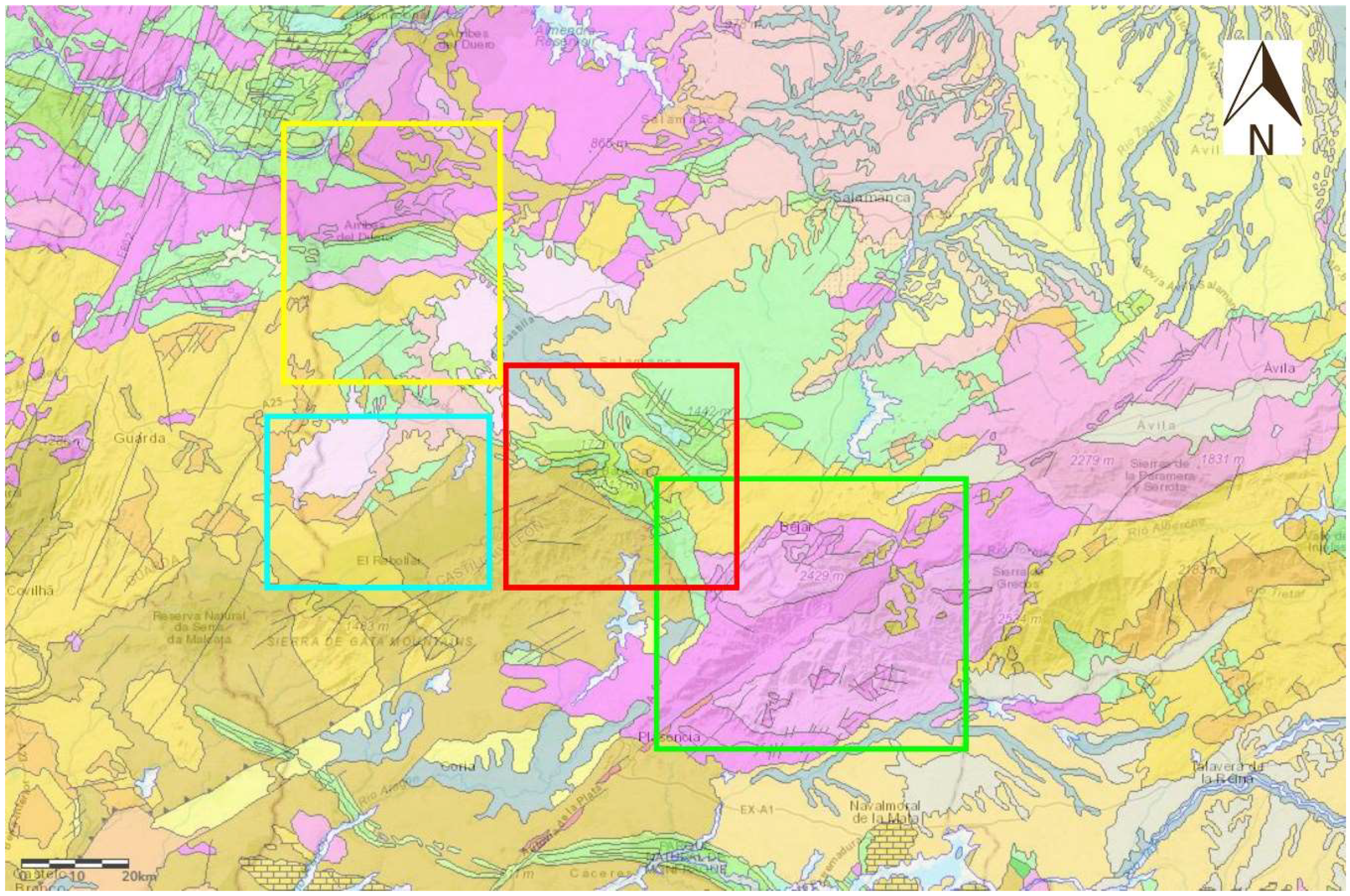
The study region is located in the Centroibérica area of the Iberian massif (
Figure 1). The geological and geomorphological characteristics of the region [
32] can be separated into two different areas based on their materials and forms.
Areas with a predominance of igneous rocks: Gredos-Béjar and Arribes del Duero and
Areas with a predominance of metamorphic and sedimentary rocks: Las Batuecas-Sierra de Francia, Quilamas, and El Rebollar.
Area 1 is characterized by materials, which occur as reactivated tectonic clumps limited by tectonic depressions (Gredos-Béjar) and by the large-scale development of granitic plutonism affected by the Varisca orogeny simultaneous with magmatism and metamorphism (Arribes del Duero). In Area 1, the relevant geomorphological element is the Pliocene fundamental surface that constitutes the roof of the mountain systems of Gredos-Candelario, and the compartmentalization of horst and graben systems in the two massifs. These morpho-structural features were affected by Quaternary glaciation, which carved cirques, slopes, and U-shaped valleys in this sector, and deposit gravitational materials in the form of talus and scree slopes (periglacial processes). In the Arribes del Duero, the main geomorphological feature is the planated topography of the Iberian basement. This has given rise to several stepped erosional surfaces, which, in turn, has given rise to a soft, rolling relief cut by large river embankments.
Area 2 is characterized by pre-Ordovician materials (Schist Greywacke Complex, lower Cambrian sandstones, and limestones), unconformable Ordovician rocks (sandstones, conglomerates, quartzites, and slate) and unconformable Silurian rocks (slate and quartzite). Paleogene and Neogene materials (sandstones and alluvial fan materials) and Quaternary materials (pebbles, gravel, sands, silts, and clays) constitute the ravines and fluvial sediments related to the current network. The main geomorphological patterns of this area are typified by Appalachian-type landforms (Sierra de Francia) and low-energy plains and pediments (Rebollar) that give rise to large inclined surfaces that affect different geological materials. Another important feature is an embedded fluvial network that gives rise to deep incisions (Duero, Tormes, and Águeda rivers).
2. Materials and Methods
The first step in this study was the creation of an inventory of the geological heritage elements in the study area, which involves identifying, locating, assessing, and classifying the places of interest (i.e., geosites). This inventory must incorporate an analysis of information on the geological characteristics, their diversity, and the value of the territory in a geological sense [
33,
34,
35,
36]. The importance of this heritage can be determined based on its scientific and/or didactic interest, as well as its cultural, recreational, and/or scenic interest in Spain. The geological services -IGME- offer a free viewer its different geosites: IELIG platform (
http://info.igme.es/ielig/).
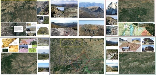
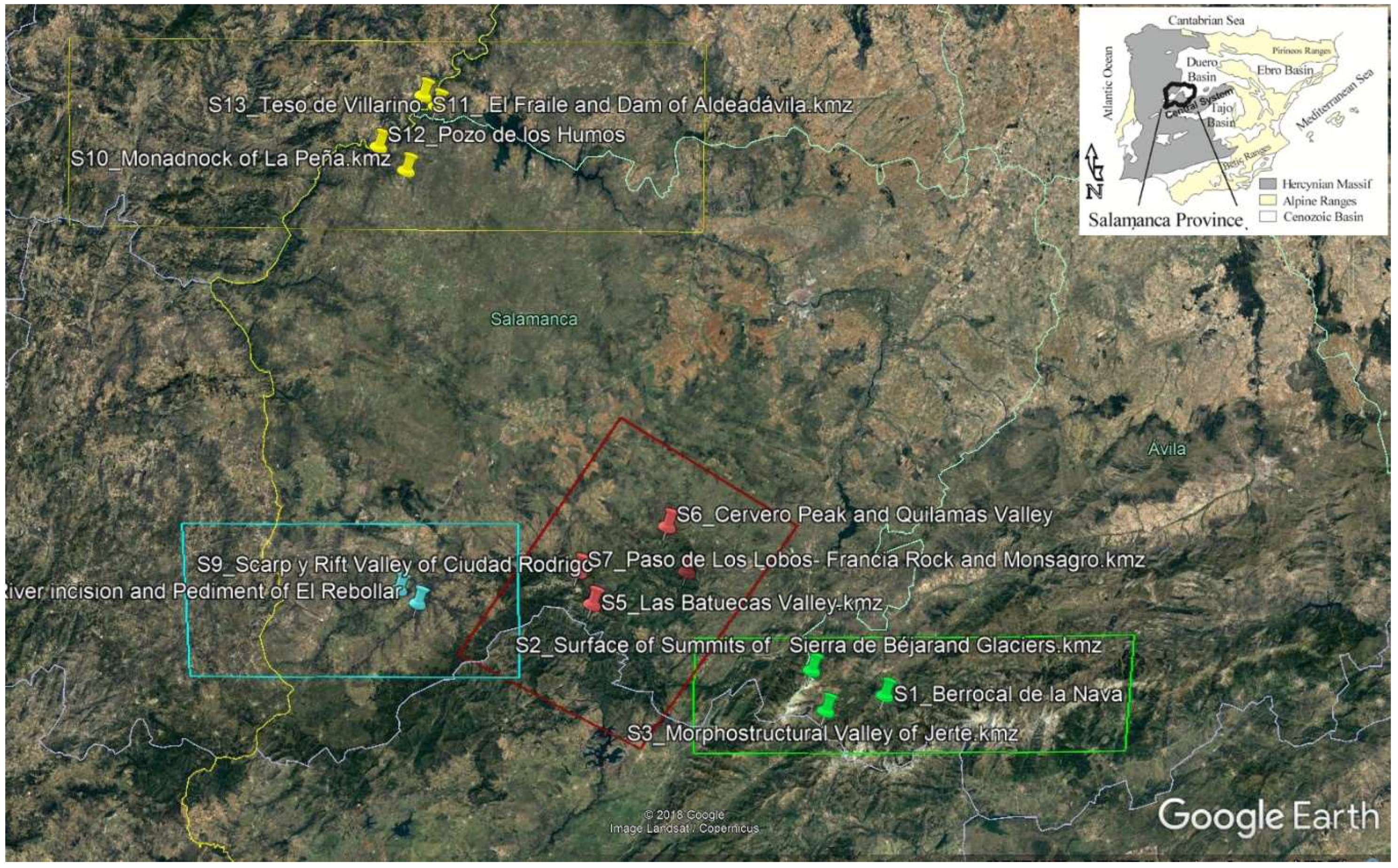
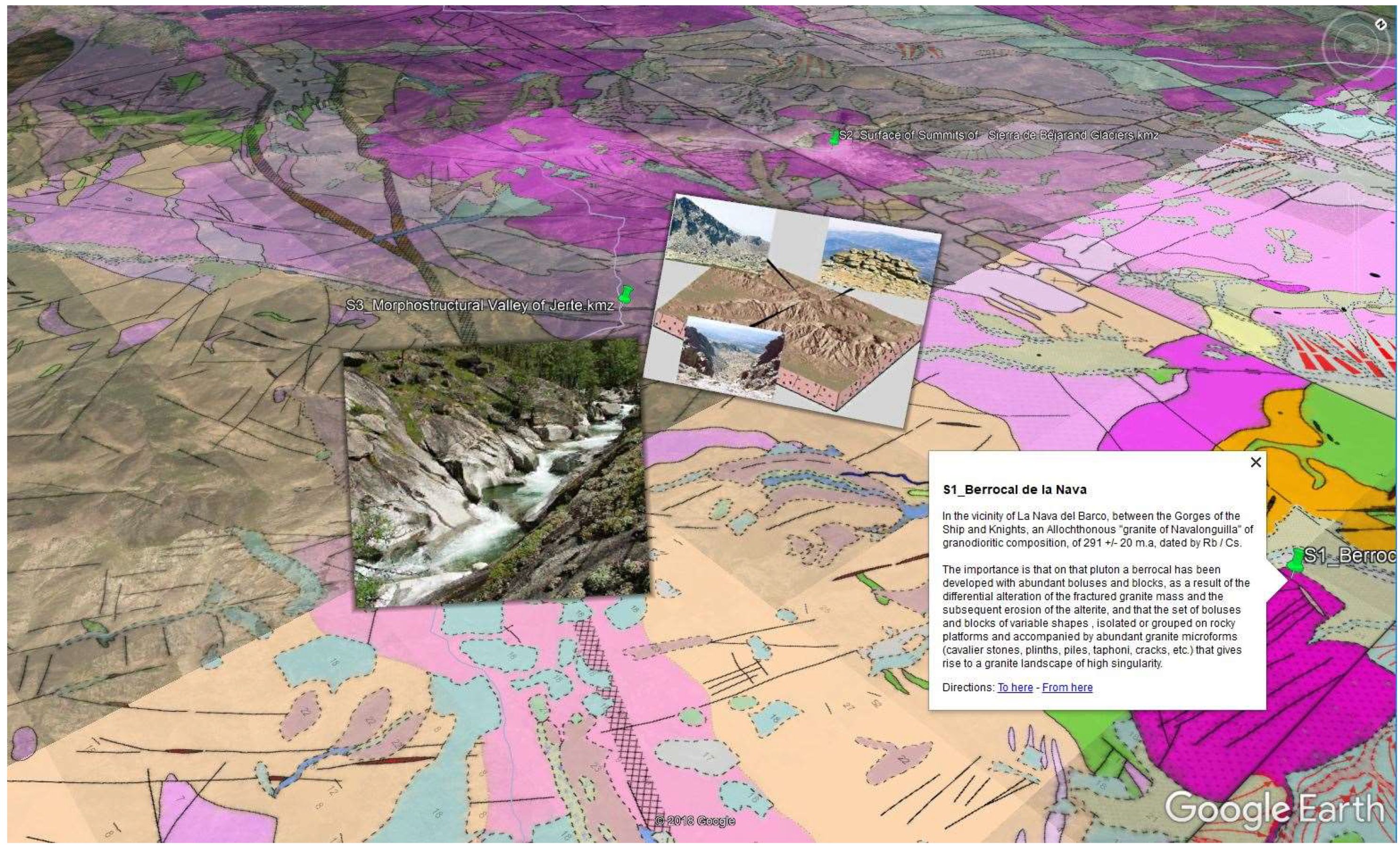
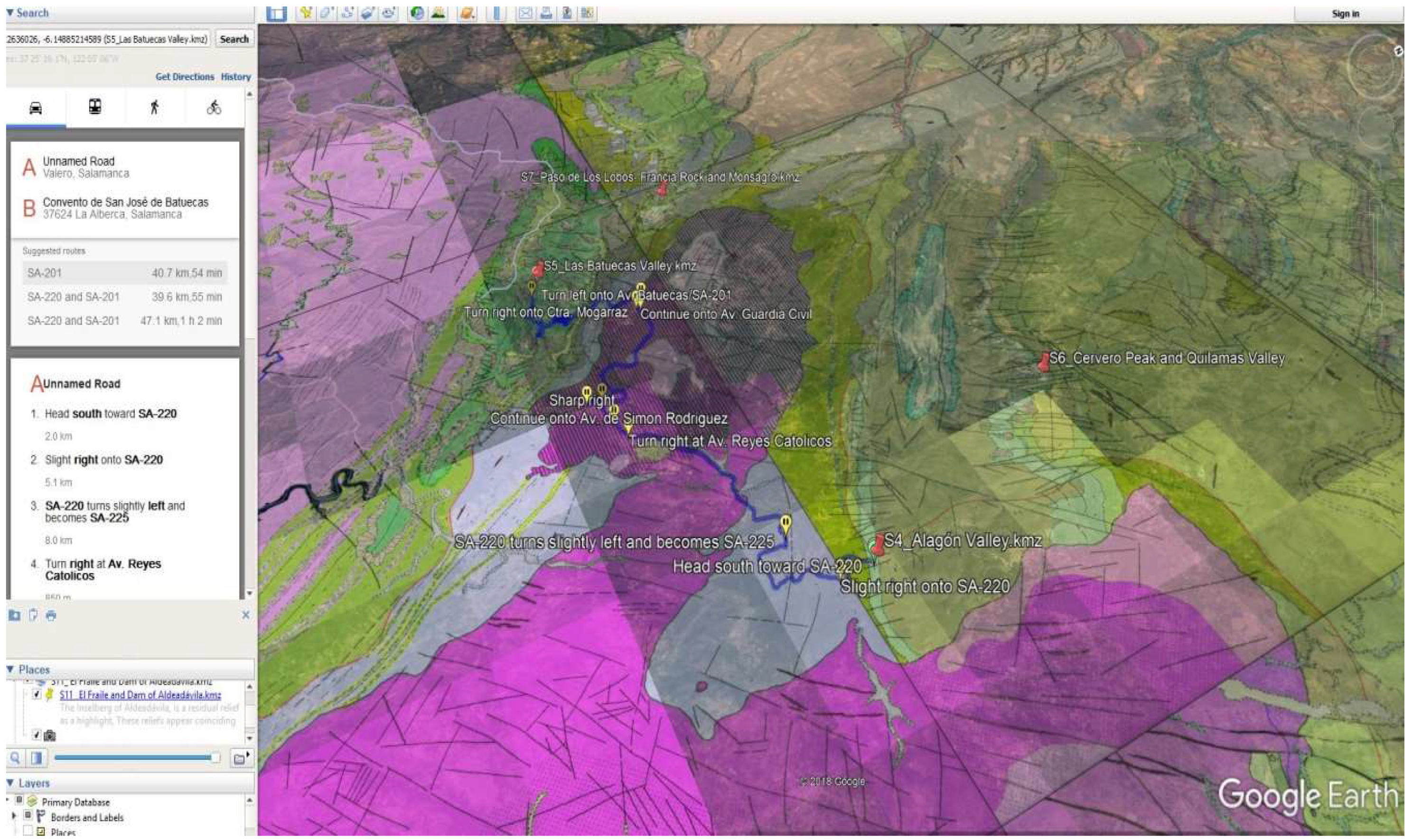
In this work, 13 geosites were selected, and denominated from east to west and from south to north and by natural spaces in the following way: (A) Gredos-Candelario natural area included the areas: (1) Berrocal de la Nava del Barco, (2) the surface of the summits of the Sierra de Béjar, Glaciar de los Caballeros, and the Lagoon systems of Duque-Trampal-Endrinal, (3) the morphostructural valley of the Jerte river. (B) The Las Batuecas-Sierra de Francia and Quilamas natural spaces included the areas: (4) the Alagón River Valley, (5) the Batuecas Valley, (6) Cervero peak and the Quilamas Valley, (7) the Paso de Los Lobos-Francia Rock and Monsagro. (C) The El Rebollar natural space included the areas: (8) pediment and fluvial incision of the Águeda river, and (9) scarp and rift valley of Ciudad Rodrigo. (D) The Arribes del Duero natural area includes: (10) the La Peña monadnock, (11) the El Fraile-Aldeadávila Dam, (12) Pozo de los Humos, and (13) Teso Villarino (
Figure 2).
The valuation was carried out according to the latest revision (2018) of the García Cortés and Carcavilla methodology [
37], which is based on assigning between 0 and 4 points to a total of 18 parameters (
Table 1) related to the geosite, namely: representativeness, character of type locality, scientific importance, conservation, observation conditions, rarity, geological diversity, educational use, infrastructures in the area, population density, accessibility, size, association with other eco-cultural elements, beauty, informative content/use, potentiality to carry out informative activities, proximity to recreational areas, and the socioeconomic environment. The data obtained for each parameter was multiplied by different weighting coefficients depending on the type of value (scientific, didactic, or tourist) that is being calculated (
Table 2). For the scientific evaluation, parameters were weighted as follows: representativeness—30 points, scientific importance and rarity—15 points, and character of type locality, state of conservation, observation conditions, and geological diversity—10 points. For the didactic evaluation, parameters were weighted as follows: content or didactic use detectable—20 points, logistical infrastructure—15 points, accessibility and geological diversity—10 points, and representativeness, character of type locality, the state of conservation, etc.—5 points. For the tourist assessment, parameters were weighted as follows: the spectacularity or beauty—20 points, the size of the geosite and the content or informative use—15 points, the accessibility and socioeconomic environment—10 points, and observation conditions, logistics infrastructure, population density, etc.—5 points.
To facilitate the description of the selected elements, files were expanded in order to contain information about their location, type of heritage, uses, maps, diagrams, photographs, and description of characteristics including a semiquantitative analysis. Various types of information are contained in each file. There are descriptive data and assessment data. Assessment data are susceptible to undergo modifications over time. The informative and descriptive data include: number and denomination, description, flat location map and orthophoto, representative photographs, and geological and geomorphological schemes.
From the identification and assessment of the 13 geosites, the methodology followed for the realization of the virtual itinerary first consisted of a compilation of the digital information of the different thematic layers used for a correct visualization of the described geological heritage. These layers were geological cartography imported in a vector format and in a KMZ format, as well as a Digital Elevation Model (spatial resolution 5 m). The orthophotos and satellite images were obtained from the platform of the National Geographical Institute of Spain in "raster" format. This information was then integrated, using a geographic information system, into the same reference system, so that it could be superimposed on a virtual globe.
Second, we proceeded to georeference the different geosites and to create an abbreviated description for each one (For details, please see
Supplementary Materials). This involved generating position marks with different symbology and adding field photographs, interpretive schemes, and valuation tabs for each site onto the virtual globe. The Google Earth application allows georeferenced geosites to be exported in a vector format (points) as a KML layer, or to be generated with the "add" menu by using a "placemark" and moving that mark to its exact place. In the properties of each point of geological interest, the user can add a description of the place and add different icons, which allows different thematic itineraries to be expanded (lithological route, active process route, etc.) and to indicate each site with a different symbol color. The user can also add photographs of the outcrop, site, structure, or interpreted geological cut. If it is generated with Google Earth, it must be saved using the "save place as" option, in the KML or the KMZ format. The online distribution of these points is fast due to their small size (text between 1–10 kilobytes and images between 1–10 megabytes, depending on the quality of the imported image).
On the left side of the Google Earth user inferface, the "my places" window allows the user to activate and deactivate each geosite, and to modify it and add new images. The user can zoom in or out on each geosite, and, at higher zoom levels, the information (texts and images) of the closest points and a descriptive text of the geological-geomorphological interest are visible. The user can give a degree of transparency to the cartography to overlay elements of the territory that are of interest such as roads, population centers, and more.
Next, we implemented teaching resources to each geosite in such a way that they are georeferenced and activated for geosite images of the different outcrops, schemes, and interpretative drawings, such as topographic profiles in a zone of great fluvial fit, photographical interpretation of outcrops observed from a geosite, photographs, cards with the valuation of each geosite, and more (
Figure 3). Photographs were uploaded and displayed when zooming in on the geosite, and can activate or deactivate the different resources that help us locate and analyze the site. The superimposition of photographs (unlike the thematic cartographies, which were georeferenced and exported in KML format from GIS for superposition on the 3D globe) was performed by using algorithms integrated in Google Earth, which are able to move the figure both vertically and horizontally in space. This allows the images to be interactively rotated in 360° and, thereby, visualized from different positions (
Figure 4).
Lastly, we loaded digital information into the Google Earth platform in order to establish a series of 3D virtual flights in the itinerary. These were implemented in different formats (mpeg, avi, wma) in order to be reproducible using different multimedia systems (PCs, DVDs, etc.). The methodology described is compatible with the implementation of geological heritage cartographies in web applications, viewers, and geoportals, which allows the different thematic layers generated in this study to be supported in various virtual viewer and geoportal applications that are both free (Google Earth) or purchased (Terra Explorer). The obtaining, management, analysis, representation, and graphical outputs of the thematic information are favored: geology, geomorphology, and geological heritage georeferenced by means of the "dump" of this digital geodatabase into a newly created spatial data infrastructure (IDEs) or "hanging" of already created spatial data infrastructures (European, national, regional administration), which facilitates the use of "augmented reality" whose purpose is to visualize and manage information through an Internet browser, a mobile phone, a PDA, or a laptop. Users can search for, visualize, and combine information about the geological heritage and geodiversity. This methodology is intended to disseminate heritage information and to apply geospatial resources in research, education, didactic, and geotourism applications for their value and conservation [
38,
39,
40,
41,
42,
43].
3. Results and Discussion
(1) Boulders field of Nava del Barco (
Figure 5a): granodioritic mass with morphology and with abundant field and block boulders, formed by the differential alteration of the fractured granitic mass and subsequent erosion, which has given rise to a set of highly variable forms, including Glaciers, dome forms etc., isolated or grouped on rocky platforms and with abundant smaller granitic forms (gnammas, tafoni, cracks, paviments, rock donuts), which generate a singular granitic landscape.
(2) Surface of the summits of the Sierra de Béjar, Glaciar de los Caballeros, and Duque-Trampal-Endrinal System (
Figure 5b): the surface of the summits of the Sierra de Béjar correspond to a piece of an old erosion surface, which resulted from the planation of the Variscan orogen during the Mesozoic Era and sunk to its current position (2000 m a.s.l.) during the Alpine orogeny during the Oligocene and Miocene eras. This surface presents numerous residual reliefs and the beginning of the glacial system cirques such as the Glaciar de los Caballeros. This is a complex glacial valley, which communicated with other adjacent glaciers through transfluence hills in the Last Glacial Maximum.
(3) The Jerte morphostructural valley (
Figure 5c): the importance of this location of geomorphological interest is that it allows the analysis of the lithostructural control of the Jerte River, which follows the trace of a well-known fracture system in Spain and Portugal (Falla de Alentejo-Plasencia), and the interpretation of its current morpho-structure as a tectonic pit accompanied by a slopes stand, which overlaps the previous staggering of blocks. This is a result of a tectonic inversion produced by the collapse of blocks in the Plio-Pleistocene. Geomorphological anomalies can be recognized due to neotectonic effects such as fluvial tracings linked to tectonic guidelines, tectonic jumps in gorges, and the tilting and breaking of terraces.
(4) The Alagón River Valley (
Figure 5d): this sector contains geomorphological, structural, paleontological, and stratigraphic singularities. In its beginnings, the valley presents great unevenness in its ravine, which generates the natural cut and exposure of the disposition of the Armorican quartzite of Ordovician age, corresponding to the southern flank of the syncline of this sector. There are quartzite benches with in situ ichnofossils of Cruziana and Daedalus and structures of parallel and crossed lamination.
(5) Batuecas Valley (
Figure 5e): the Batuecas River fits and deepens in less resistant lithologies (shales, siltstones), and, when it crosses the resistant Armorican quartzite, it generates rapids, waterfalls, potholes, etc. The surface of the plain contrasts with the deeply carved canyons through the fluvial network, where folds, faults, and Ordovician ichnofossils are observed. The altitude difference generates bioclimatic contrasts that condition vegetation and fauna. In the landscape, highlights and outcrops of Armorican quartzite of different colors are observed. Additionally, the valley has archaeological value (cave paintings), cultural value (hermitages), and landscaping.
(6) The Cervero Peak and Quilamas Valley (
Figure 5f): this area presents a periglacial record with typical morphologies such as stone circles and patterned ground. Signs of cryoclastic and rupture processes are observed in Armorican quartzite blocks by periglacial morphogenesis that generated niches and block cords in favor of slope. In the Quilamas Valley, degraded surfaces at various levels can be observed, which show the different phases of the Quilamas stream. These surfaces stand out in reliefs further to the west, where Cambrian limestones appear in unconformity with the Ordovician quartzites. These limestones consist of carbonated outcrops with well preserved sedimentary inorganic structures such as laminations, desiccation cracks, and organic-derived structures including algal meshes, stromatolites, and oncoids dispersed between aligned and aligned dolines. In some cases, they form uvalas, which generates a karstic landscape in their crests with microforms of differential dissolution at locations where limestone outcrops.
(7) Paso de Los Lobos-Francia Rock and Monsagro (
Figure 5g): from the Los Lobos hill, one can observe Appalachian relief with suspended synclines, and inverted reliefs including vertical didactic folds with feathery diaclases. La Peña de Francia is a unique relief in which Armorican quartzite is observed, which presents organic structures such as Cruziana, Skolithos, and Daedalus, among others, and inorganic structures (laminations, ripples, etc.) that can be interpreted in a didactic way. In the direction of Monsagro, there are different grades of slopes that give rise to extensive scree that generate natural springs. The streets of the town of Monsagro are an authentic open-air museum where one can observe many ichnites (fossilized footprints) and ripples attached to the facades of the houses. An interactive
georuta (geo-route), the so-called Fossil Footprint Route, has been made to enhance geotourism in rural high mountainous areas [
35].
(8) Águeda River fluvial incision and pediment of El Rebollar (
Figure 5h): this incision generates a topographic entrenchment of 200 m, and constitutes an erosive form of fluvial morphogenesis that includes the whole Águeda River Valley, which has steep slopes and runs sub-parallel to the Sierra de Gata (NE-SW) controlled by deep fractures. The valley has a "V-shaped" morphology with a remarkable geomorphological reflection on the pediment. The pediment is an erosive form of polygenic morphogenesis that appears as a flattened surface of a relict that was covered during the Mesozoic by sediments with powerful weathering mantles and was totally eroded during the Cenozoic. A landscape with smooth forms is generated in folded metasedimentary substrates and is more abrupt in more resistant granite substrates.
(9) Scarp and rift valley of Ciudad Rodrigo (
Figure 5i): this escarpment is an example of a fault scarp and constitutes the articulation between the Gata pediment and the Ciudad Rodrigo Basin. It is the geomorphological reflection of a fault system and manifests as a narrow and elongated band in the NE-SW direction. This morphological escarpment has a vertical drop of 100 m, the upper surface corresponds to the Gata pediment and the lower surface to the base level of the Águeda River in the depression or the Ciudad Rodrigo Trench.
(10) La Peña monadnock (
Figure 5j): in the Arribes del Duero, isolated granite forms are observed, which stand out abruptly from the surrounding plains and appear as "islands in the sea." One of these forms is the La Peña monadnock, measuring 71 m in diameter and 41 m in height, which underwent hydrothermal processes subsequent to the emplacement of magma, which presents evidence of processes of episienitization. From a geomorphological point of view, the maximum height of the La Peña monadnock coincides with other residual reliefs in the Arribes del Duero natural park, constituting one of the surfaces that existed prior to the presence of the fluvial network.
(11) El Fraile-Aldeadávila Dam (
Figure 5k): the inselberg of Aldeadávila is a residual relief with great prominence due to the presence of more resistant materials, where structural platforms forming tables or molars are observed. This feature illustrates the effect of fluvial erosion on a homogeneous batholith. At this location, there are two entrenched rivers including the smallest of which is the Uces River and the largest of which is the Douro River, with a difference in height of over 500 m, which, in this section, forms a natural border between Portugal and Spain.
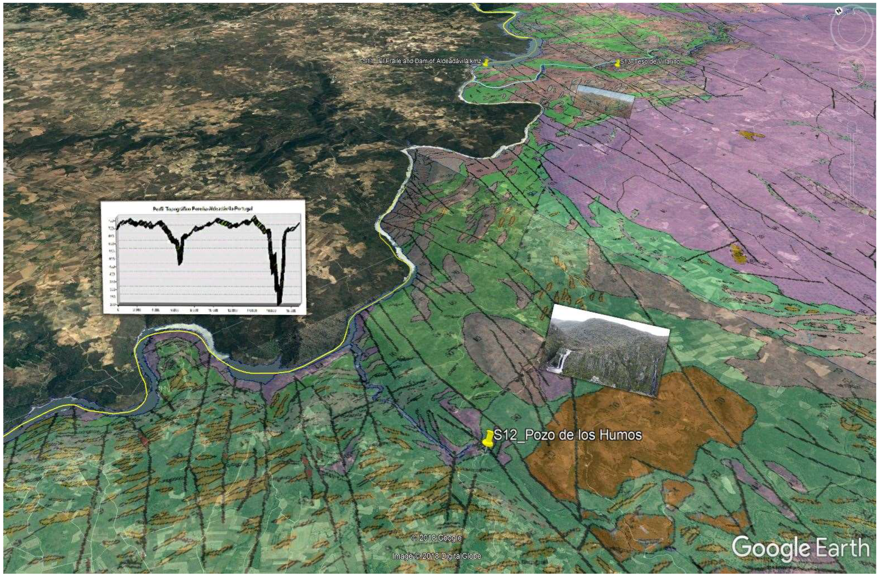
(12) The Pozo de los Humos (
Figure 5l): this is an area of the Arribes del Duero of great geomorphological and geological interest, where the entrenchment of the fluvial network facilitates the study of geological sections. A large waterfall with a height of 50 m has been formed due to the presence of granite sheets at different heights, which have undergone fracturing transversal to the Uces River channel.
(13) Teso de San Cristóbal (
Figure 5m): In this area, the fluvial entrenchment of the Tormes River, and its mouth in the Douro River reveals structural features of the old basement rocks, such as granitic sills. Additionally, typical morphologies of granitic landscapes with large forms (granitic boulder field, etc.) and smaller forms such as grooves and gnammas are present.
The unweighted valuation (
Table 1) reflects very high scores, in general, for almost all the selected geosites. The highest value was obtained for geosite 7, that is, Paso de Los Lobos-Francia Rock and Monsagro, which obtained a score of 54 (from a maximum possible 72). This was followed by geosite 11 (49 points) and geosites 5 and 3 (48 points each). The fact that the vast majority of geosites presented here correspond to areas of kilometric dimensions means that they always reach the maximum values of four points for some parameters, such as "viewing conditions," "geosite size," and "potential for tourism/recreational activities."
The total weighted values discriminated by scientific, educational, and tourism/recreation interest are given in
Table 2 and
Table 3. The highest total value of 975 points corresponds to geosite 7, which also obtained the maximum values for the three individual measures (scientific, educational, and tourism/recreation) considered, that is, 325 points in each. This is due to the fact that this geosite obtained the maximum value of four points for 12 of the parameters considered. The wide geographic extension of the site ensures accessibility, which allows the likelihood of tourist activities. Many educational activities have been carried out for years at this location at the level of intermediate education, undergraduate degrees, and master’s degrees in geology, geological engineering, biology, and environmental science. This site also contains the previously mentioned "outdoor museum" in the town of Monsagro, which, in July 2018, was inaugurated as the "Interpretation Center of the ancient seas of Monsagro." This is a geological-paleontological museum that includes the latest interactive technologies, where the visitor is "immersed" in the Ordovician sea that once covered the area, in order to understand the formation and evolution of the structures that are visible in the streets of the town (
https://www.turismocastillayleon.com/es/rural-naturaleza/rutas-naturaleza/ruta-huellas-fosiles-monsagro). Geosite 7 is followed by geosites 11 (El Fraile-Aldeadávila Dam) and 5 (Batuecas Valley), which obtained total values of 850 and 825 points, respectively. El Fraile-Aldeadávila Dam also obtained high scientific (265 points) and touristic (300) scores. The petrological and geomorphological characteristics of the Aldeadávila inselberg have been popular study locations for several field trips of international meetings. There are also numerous tourist activities offered in the area, including fluvial cruises and activities related to the area’s endemic botanical species and large birds (black stork) that are in danger of extinction. In Batuecas Valley, the educational (295 points) and tourist (285 points) interests are higher.
Considering each natural park as a whole, the Batuecas-Sierra de Francia-Quilamas geosites obtained the highest values, which was followed by those in Arribes del Duero and Candelario-Gredos. The natural park of El Rebollar contains only two geosites of which number 6 (Águeda River-El Rebollar pediment) obtained the lowest value with 545 points.
The large number of geosites identified shows the great geological diversity existing in these natural spaces of Salamanca. Geological itineraries have been developed in each natural space based on the 13 geosites identified. The most representative sites were then determined using a scientific, didactic, and touristic context, which allows us to identify and interpret the singularities of the existing geological elements in each natural space.
The layout of each itinerary generated in this work can be followed in real time using mobile devices. In this way, part of the information that is currently presented in panels, posters, brochures, and guides could be replaced by augmented reality, which allows open digital documentation in addition to photographs, diagrams, graphics, and terrain profiles to be displayed for each geosite (
Figure 6). The use of GPS incorporated in mobile devices (smartphones, tablets, PDAs, etc.) allows the user to obtain up-to-date information about the situation regarding the routes for each one of the geosites of interest. For each geosite, by activating the “thumbtack,” it is possible to open a description of the point on a virtual globe, and, in the same window, to mark routes between geosites, which allows the best route to be determined or to realize a thematic itinerary. For example, traversing geosites with paleontological particularities give freedom to the user to follow their interest in the different stops along the route (
Figure 7).
The free Google Earth platform allows the recording of video (
Figure 8) for the itineraries, in which all the resources can be implemented—photographs, diagrams, etc.—so that it can be exported to common video formats, which allow wide diffusion, such as mpeg and avi. This allows the video to be reproduced on computer systems (PC, Mac, etc.) and non-computer media (DVDs, Hard Drives, multimedia, etc.), which facilitates the enhancement and globalization of the geological heritage of these natural spaces. These virtual techniques facilitate teaching–learning processes by awakening creativity and imparting knowledge as well as improving interactive skills and abilities when using new technologies. The type of itineraries mentioned here allow geological tourism and, more generally, “geotourism” to be enhanced, and can also be used for the planning, management, and valuation of geological resources, which attract specialized tourism and generate employment in sectors of great natural beauty in addition to being sustainable [
44,
45,
46].
4. Conclusions
Among more than 100 geosites in the four natural parks of the west and south of the province of Salamanca, the 13 most representative were chosen for their relevant geological heritage. The sites were valued for their scientific, educational, and tourist/cultural interest, and calculated value scores ranged between 595 and 975 points. Additionally, digital information were added to each geosite with which a user can interact using software.
The realization of 3D virtual flights using free public applications (Google Earth, Google Maps, etc.) and purchased applications (Terra Explorer) means that the layout of a previously developed itinerary can be followed in real time using mobile devices. Such an approach could allow part of the information currently presented in panels, posters, brochures, and guides to be replaced through augmented reality, which would allow for open digital documentation, in addition to photographs, diagrams, graphics, terrain profiles, etc., to be displayed for each geosite. Such an approach could be used with computer reproduction systems (PC, Mac, etc.) and non-computer media (DVDs, Hard Drives, multimedia, etc.), which would facilitate the enhancement and globalization of the geological heritage of these natural spaces. These virtual techniques facilitate teaching–learning processes for students of different educational levels, awaken creativity and impart knowledge as well as improve interactive skills and other skills when using new technologies.
The type of itinerary mentioned here also allows the fostering of geotourism, as well as its use as a criterion in the planning, management, and enhancement of the geological heritage of these natural spaces. All of this undoubtedly favors sustainable development in areas with very low population and low socioeconomic level (with incomes below the national average). This is the case in the study area. With all of the geological information generated, and with the possibilities offered by geomatic tools, the idea of proposing a future "Geopark of the three mountain ranges and the three rivers of Salamanca" has that objective.

 ,
, 


