Abstract
Disaster reduction is one of the most important keys towards sustainable development. Using a number of case studies, the present work was intended to elucidate the need for improved communication between the urban flood management community and the road planning sector for better flood risk management. These cases were classified in three categories: (1) Road tragedy during evacuation, (2) Why some roads are vulnerable to flooding, (3) How to quickly evaluate the potential impact of road construction on surface drainage characteristics. These cases provided strong evidence that insufficient dialogue between water and road sectors may hinder sound flood risk management by recommending wrong flood evacuation routes that are life threatening and neglecting the impact of road construction on the alteration of surface drainage characteristics. These cases were selected purposively but not comprehensively. Based on findings from these case studies, it can be stated that evacuation safety should be improved through better communication between flood risk and road management professionals, which in turn will lead to better road planning.
1. Introduction
A road network is the most fundamental infrastructure component, and it plays an essential role in the economy. In the United States, for example, the road network accounts for 15 per cent of the gross national product and 84 percent of all transportation spending [1]. In Japan, the road construction was used as an engine for the country’s rapid economic growth in postwar period [2]. The objective of urban road development is to achieve high efficiency and mobility and deliver the maximum satisfaction to residents [3]. An efficient road system gives a country or region a competitive edge in moving people, goods, and services safely and economically. Conversely, a lack of accessibility or poor road conditions are barriers to agriculture, industry, and trade, and may hinder the overall development effort. To date, a wide range of issues has been thoroughly studied with regard to road construction and management. These include traffic safety, air pollution, noise, impacts on wildlife and water quality, and the spread of invasive species. In recent years, the impacts of extreme weather events on traffic flows and travel behaviors have received much attention in transportation research [4,5,6,7]. In a previous study, a relationship between the depth of floodwater on roads and vehicle speed was reported [8]. Another study estimated the cost of flood-related traffic disruptions on main roads in the United Kingdom [9] and discussed flood-related road scouring and washouts [10]. However, these studies tended to focus on flood damage to roads and vehicles, and road closures and traffic chaos caused by flooding. In other words, they were mainly concerned with the susceptibility of roads to flooding and the potential impacts of weather on individual daily travel behaviors (i.e., they were transportation-oriented studies). Other related works include a study on the impacts of road networks on inundation patterns [11], a study identifying the root cause of street flooding in metropolitan Manila [12], and an urban vulnerability study focusing on emergency services access during flooding [13]. Over the last two decades, there has been a considerable amount of research on evacuation route planning for natural disasters. However, these works have emphasized the minimization of evacuation times [14,15]. To date, the topic of traffic disruptions caused by flooding and its consequence in relation to evacuation safety has still not received sufficient attention. The question of how the presence of a road network affects flood preparedness and emergency response needs to be addressed in depth.
On the other hand, urban flood modeling has progressed over the past several decades from simple 2D overland flow models to sophisticated models that can deal with urban features, such as sewer systems and buildings. These include the SOBEK and MIKE flood modeling systems. However, the modeling capability to predict road flooding and quantify its impact on evacuation and rescue activities is still very limited for primary three reasons. First, the prediction of road flooding requires high-resolution surface elevations and road network typological data, which are often difficult to obtain. Second, roads may have sudden changes in elevation. This invalidates the assumption of mild surface slopes, which is fundamental to most of the models in use today. Third, there are often a large number of cars running on roads. The inundation depths on roads are affected by the presence of cars, which causes large uncertainties in the prediction of road flooding.
This paper is aimed at highlighting the importance of considering the presence of road networks for better flood management planning and effective flood emergency operations. It also intends to present a holistic approach to qualitatively evaluate the possible alteration of surface runoff due to the presence of road and a framework for integrating flood risk and emergency management with road management. The most important message delivered by this paper is that creating and enhancing the dialogue between flood risk management and road engineering sectors is essential for the advancement of both sectors.
2. Materials and Methods
Road network patterns reflect the morphology of a city. There are some cities in which the road network patterns are mainly grid systems. Other cities may have road networks that are composed of radial and ring roads. There are also cities in which the road networks patterns are curved and irregular. To date, graph theory has been used to address the entire topology of an urban road network. Marshall studied road networks using graph theory and proposed a taxonomy of main general road patterns: linear, treelike, radial, cellular, or hybrid [16]. Other related studies to recognize the patterns in urban networks or analyze road networks were conducted by Jiang and Claramunt [17], Mesev [18], and Barthélemy and Flammini [19]. However, these studies were conducted in the transportation field and had no link to urban flood disaster management. Therefore, the relationship between road network characteristics and flood risk still needs to be addressed.
Because of the complexity of road networks, the present work employed a case study approach to identify issues concerning the relationship between roads and urban flooding and provide an in-depth, multifaceted understanding of these issues. The focus of the study was on how a lack of consideration of road conditions can affect flood evacuation and the vulnerability of roads to flooding. A critical case sampling method, which is defined as the process of selecting a small number of important cases—cases that are likely to yield the most information and have the greatest impact on the development of knowledge, was adopted to choose study targets because it suited the research objective and could reveal insights that are applicable to other similar cases. Besides, sampling for proportionality was not the main concern of the study.
These cases selected can be grouped into three categories. The first is road tragedy during flood evacuation, which is aimed to highlight that designated evacuation routes might be life threatening due to insufficient consideration of road inundation. The second is road vulnerability to flooding, which is aimed to analyze why some roads are exposed to flooding and highlight the possibility that the road tragedy cases in group 1 may occur again in a similar way at other places because access roads to shelters are not safe. The third is attempted to address a fundamental issue that is how the presence of a road alters surface runoff patter. The impact of road construction on surface imperviousness has been well documented. However, the impact of road construction on surface runoff pattern has received little attention so far. Although the direct link among the three groups of cases is weak, they all serve a common purpose of pointing out different aspects where the dialogue between water and road engineers is urgently needed.
For group 1, flood fatalities and the locations of tragedy were obtained from local government and confirmed by author’s independent field surveys. Numerical simulations were also conducted to estimate inundation depth and flow velocity. As a matter of fact, these simulations were done right after the disaster, and the present study re-visited these results for a new objective that is to stress the need to pay more attention to road flooding for safe evacuation and the functioning of evacuation shelters.
For group 2, road inundation records were obtained from local governments and surface elevation data were mainly obtained from Geospatial Information Authority of Japan. And some additional surface elevations along roads were measured independently. By studying road topography with Google Street View and surface elevation along roads, the study revealed some factors that cause the vulnerability of road to inundation. Besides, narrative approach was also employed for explaining underpass-induced problem. Overall, it identified shortcomings in the current flood risk management and emergency response planning related to roads.
For group 3, the function of ArcGIS to generate a stream network from Digital Elevation Models (DEMs) was utilized to investigate how the presence of a road may affect the drainage pattern by comparing the stream networks generated with and without the consideration of a road. The surface elevation along National Road No. 8 was surveyed using Differential Global Positioning Systems.
Finally, a policy framework was proposed for improving flood evacuation operation based on road vulnerability studies and for promoting better road construction planning to minimize road flooding and the alteration of drainage pattern due to road construction.
Overall, the research methodology used in the present study can be characterized as a mixture of variable-centered engineering analysis and narrative explanations. Narratives convey not just information but also understanding so that it is appropriate for exploratory study. In the present study, the use of narrative approach helps make sense of the ambiguity and complexity of road-flooding connection.
3. Results
3.1. Group 1 Road Tragedy
Case 1: Sayo Town flooding
On August 8, 2009, because of heavy rainfall, the Sayo River in the Hyogo Prefecture of Japan overflowed and breached. At 9:00 p.m., an evacuation call was issued by the Sayo town office. Following this call, a group of 11 persons in the Makuyama district left their residences and moved toward a designated shelter, as shown in Figure 1. However, by that time, the Makuyama River, in the same district, had also overflowed. The floodwater from the river entered an irrigation channel, which runs in parallel to National Road No. 365 (Figure 2). As the group was crossing the road, the channel overflowed and inundated the road. The floodwater exiting the channel washed the group away, and nine of the 11 people perished. A field survey after the disaster observed a floodwater mark on a nearby utility pole, indicating that the inundation depth had been about 80 cm. Then, by measuring the road slope and width and using the Manning formula, the flow velocity was estimated as greater than 2.5 m/s at the time of the incident. This tragedy serves as a strong reminder that the possibility of road inundation should be considered as part of evacuation planning and operations.
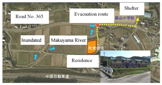
Figure 1.
Designated evacuation route and shelter.
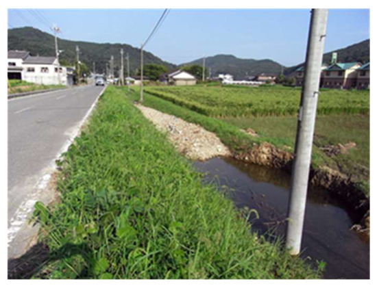
Figure 2.
Irrigation channel parallel to National Road No. 365.
Case 2: Flood disaster in Sanjo City
On July 13, 2004, a heavy storm caused a levee breach on the Ikarashi River, which resulted in the inundation of a large area of Sanjo City, Niigata Prefecture, Japan [20]. Fifteen people died in this flood disaster [21]. Among them, a healthy 42-year-old woman left home for a shelter on foot but was swept away by floodwaters on a small road, just 100 m from her residence. At another location, a 78-year-old woman was also swept away by floodwaters, just 120 m from her residence while walking on a small road toward a shelter. According to a survey we made immediately after the disaster, the 42-year-old woman left her home shortly after the levee breach, whereas the 78-year-old woman likely left her home a few hours after the breach. Therefore, 2-D flood inundation simulations were conducted [20] and the simulated inundation depths one and three hours after the levee breach (approximately the times at which the two women lost their lives) are shown together in Figure 3. It can be postulated from the depth information on the maps that because of its proximity to the river, the road from which the 42-year-old woman was swept away had a higher water depth and flow velocity than the road on which the 78-year-old woman perished. This case also indicates that age or physical condition of evacuee should be dealt with as an important factor in addition to road conditions when discussing evacuation safety. Another two victims died when floodwaters washed their cars away, and other tragedies occurred inside houses. Aged people constitute a significant proportion of those at risk from natural disasters due to their physical and cognitive vulnerability in an aging society such as Japan. According to the World Disaster Report [22], 26 million aged people are affected by natural disasters every year and this number is estimated to double by 2050. Therefore, this case raised an issue about conditions under which aged people may not be prompted for going out for shelter but seek alternative ways of threat avoidance such as moving up to the second floor of their homes if available. Fourteen years past since this tragedy, however, the guideline for the evacuation of aged people has not been prepared yet in Japan.
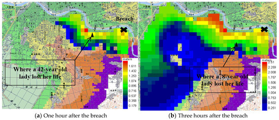
Figure 3.
Inundation depths one hour and three hours after the levee breach and the locations of the tragedies.
3.2. Group 2 Road vulnerability
Case 3: Edogawa Ward
Edogawa Ward in Tokyo is a flood-prone area in which 70% of the land is below sea level. It is bounded by the Arakawa River in the west, the Edo River in the east, and Tokyo Bay in the south. In 1981, more than 10,000 households were flooded as a result of heavy rainfall. Figure 4 shows the roads where inundation occurred during the 2010–2016 period. As seen in the figure, a major road (National Road No. 14) has a 2-km-long section that is vulnerable to flooding. The variations in road surface elevation along this section are shown in Figure 5. The ups and downs along the road section may be considered as a main cause of its vulnerability. Figure 6 shows the flood hazards both in terms of potential inundation depths and the locations of designated evacuation shelters. An examination of access to the shelters reveals that some of them may not function during a disaster because the access roads may be closed due to flooding. An enlarged view (Figure 7) clearly shows that a designated flood evacuation shelter (Matsue 3rd Junior High School) is surrounded by roads that are at risk of flooding. Furthermore, a road next to the ward office is also susceptible to flooding, which could hinder an emergency response by the administration. This case study highlights the need to integrate the flood evacuation plan with the road management plan.
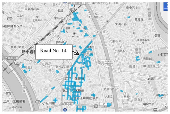
Figure 4.
Roads flooded at least once during the 2010–2016 period.

Figure 5.
Profile of the vulnerable section along National Road No. 14.
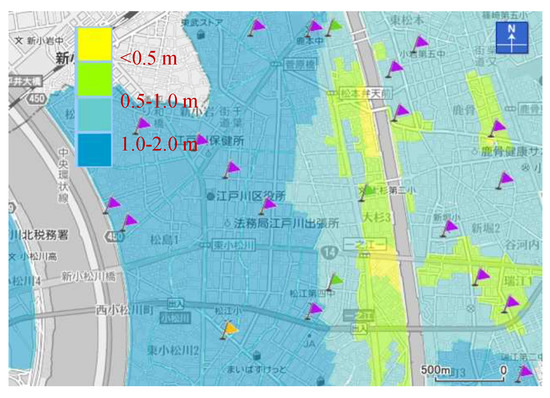
Figure 6.
Flood hazard map and shelters (flags).
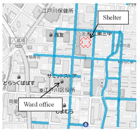
Figure 7.
Close-up view of a shelter surrounded by roads with a high possibility of being flooded.
Case 4: Koto Ward
Koto Ward is a part of Tokyo Metropolis, having an estimated population of 488,632 and a population density of 12,170 persons/km2. The total area of the ward is approximately 40.16 km2. It is largely a low-lying land, bounded by the Sumida River to the west and the Arakawa River to the east. In the present study, information on the road flooding that occurred in Koto Ward during recent years was collected from the ward office and analyzed to elucidate its characteristics. As seen from Figure 8, the length of flooded roads ranged from about 400 m to 6000 m over this period of time and seems to have a declining trend, although it was not statistically validated due to the limited amount of data. The most noticeable feature of the road flooding in Koto Ward was that a section of National Road No. 14, as indicated by circle in Figure 9, was flooded in six years out of the seven years considered.
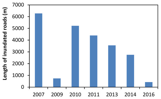
Figure 8.
Annual change in total length of inundated roads in Koto Ward.
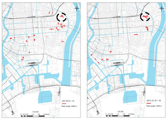
Figure 9.
A frequently flooded road section in Koto Ward (marked by circle).
To find out the cause of the road flooding there, Google Street View was used in combination with field level measurement. As can be seen from Google Street View, the east end of the road section is higher in surface elevation (Figure 10) and there is a lateral road joining this road section (Figure 11). Level measurement found that the lateral road is 30 cm higher than National Road No. 14 at the road junction. The measurement also found that the west end of the road section is 10 cm higher than the middle part of the section as illustrated in Figure 12. Therefore, this road section has a profile of vertical sag curve and may receive rainwater from the lateral road. Such a combination of sag curve profile and lateral inflow is considered as the main cause of frequent flooding in this road section. In road engineering, longitudinal road profiles are usually designed in consideration of traffic smoothness and safety. In fact, in the design of sag-curve sections, main concerns are given to traffic congestion and headlight sight distance. Except for underpasses, Japanese road construction standards take little consideration of road flooding in the design of a road’s longitudinal profile. This is an issue requiring better collaboration between flood management and road engineering sectors.
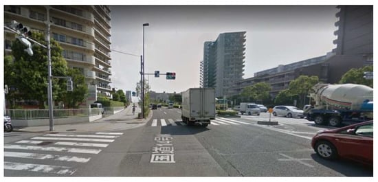
Figure 10.
Google Street View for the east end of the frequently-flooded road section.
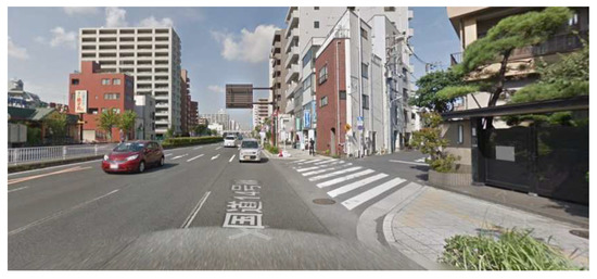
Figure 11.
Google Street View for the middle part of the frequently-flooded road section.
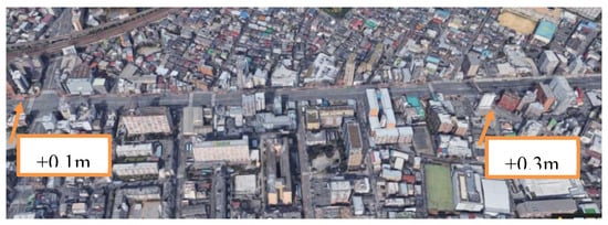
Figure 12.
Road flooding due to sag curve profile and lateral inflow.
To better understand the characteristics of road inundation in Koto Ward, the relationship between rainfall intensity and the length of road flooding for the period of 2007–2016 was examined. As seen in Figure 13, the longest length of road flooding occurred corresponding to the highest intensity of rainfall. However, there were cases in which less intense rainfall caused a longer length of road flooding.
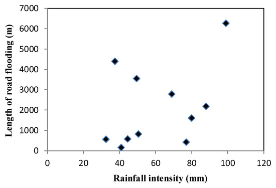
Figure 13.
Rainfall intensity and resultant length of inundated roads.
Case 5: National Road No. 16
National Road No. 16 is a ring road with a total length of 251 km, connecting major cities in Tokyo, Kanagawa Prefecture, Saitama Prefecture, and Chiba Prefecture. It is designated as the primary emergency transportation route. This study is focused on a part of the road between Noda City and Kashiwa City. The traffic volume along this part is approximately 53,000 vehicles per day. On 6 October 2014, a section of the road in Kashiwa City was inundated, and the flood depth was in the range of 20–40 cm. By using the surface elevation database, it was found that the flooded road section was a sag-curved section and that the nearby residential areas were 1–2 m higher in ground surface elevation than this road section. These residential areas were developed relatively recently, and the ground was raised to prevent waterlogging. As a result, rainwater falling in these residential areas was drained to the low-lying road, causing inundation (Figure 14). This case is an example of a housing project that took flood risk reduction measures, which led to the flooding of a nearby road. As a matter of fact, this part of National Road No. 16 was also flooded in 2013 and 2011. In 2004, a law named the “Law on Measures against Inundation Damages in Designated Urban Rivers” was implemented in a number of river basins in Japan. According to this law, the runoff increase caused by development in designated urban areas must be controlled. Although it has only been applied to seven river basins so far, a large number of cities not subject to the law have established their own regulations for runoff control. In Kashiwa City, instead of regulations, a technical guideline for runoff control was enacted in 2000 but is not legally binding. Besides, because the ground of the residential areas in consideration was raised, infiltration facilities could not be installed within these residential areas. This suggests that the drainage pattern in residential areas near a road may become a factor contributing to the road flooding there.
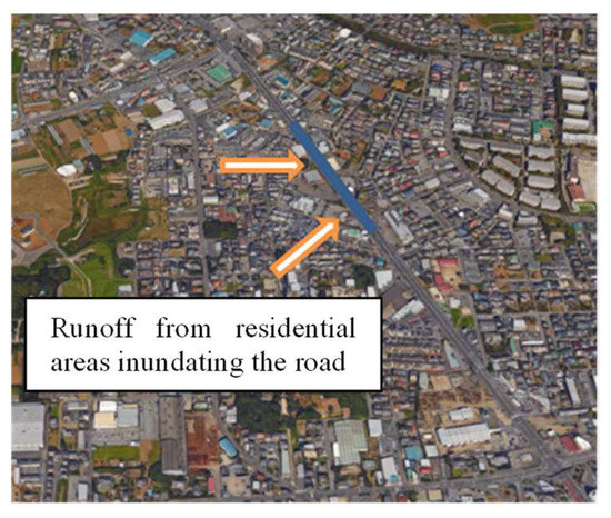
Figure 14.
A case of residential development causing road flooding.
Case 6: Underpass: one aspect of the road vulnerability to flooding
There are many underpasses along roads in Japan and many of them are vulnerable to flooding. Figure 15A–E show a number of underpass typologies, including one below another road, one below a sky expressway, one on an expressway ramp, one below a road bridge, and one below a railway.
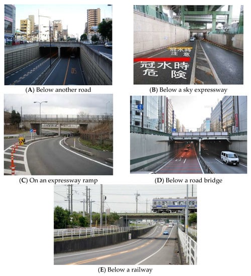
Figure 15.
Underpass typology.
In 2008, a woman drove her car into an underpass in Tochigi Prefecture and drowned. The tragedy occurred inside a type-A underpass. Following this incident, water depth sensors or cameras and sign boards showing the water depth were installed at all underpasses in the prefecture. However, a similar tragedy occurred in Aichi Prefecture in 2016 when a sign board that had been set up malfunctioned at that time. The total number of road underpasses in Japan is about 3500. At present, water level sensors and electronic bulletin boards are installed at almost all of them (Figure 16). However, the number of underpasses with closure gates (as shown in Figure 17) is limited.
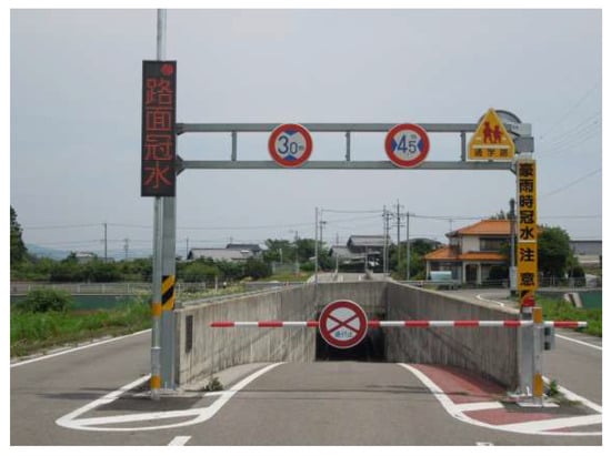
Figure 16.
Underpass with a sign board.
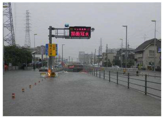
Figure 17.
Underpass with a shutoff rod.
In Japan, underpass is sometimes used to reduce traffic congestion in urban areas. A technique named as URUP (Ultra Rapid Under Pass) was developed for constructing underpass efficiently, economically and environmentally. However, such a congestion-reduction measure increases flood risk on roads. So, the lesson learned is that one sector's improvement might be another sector's degradation.
3.3. Group 3: Impact of road on drainage pattern
Case 7: Minami Ward
It is well-known that the presence of roads affects surface infiltration due to road pavement. However, how the construction of roads alters the drainage pattern of an area has been very much neglected due partially to the lack of communication between road and water engineers. In this study, a GIS-based evaluation method was proposed to qualitatively discuss how road construction might alter the drainage patter of an area, and this approach was applied to Minami Ward, Niigata City, Japan as a test case. Minami Ward is a low-lying land and surrounded by two rivers so that it is very vulnerable to flooding. A main and the most important road in this area is National Road No. 8 running from the South to North. The approach is to use the GIS stream network generation function to generate two stream networks: with and without a road for comparison. In the case under consideration, one stream network was produced using 5m-resolution DEMs of Geospatial Information Authority of Japan with ArcGIS ver. 10 without the consideration of National Road No.8, and another one was generated by combining the same DEMs with road surface elevations surveyed along the route of National Road No. 8. As shown in Figure 18, with the presence of National Road No. 8, the generated drainage channels on the left side of the road were recognizably altered. Additional numerical experiments by adding 1m to or subtracting 1m from the surface elevations along the route of National Road No.8 were also conducted. As shown in Figure 19, with the road being raised in surface elevation, the drainage channels on the left side of the road disappeared, implying the occurrence of waterlogging on the on the left side of the road. On the other hand, lowering the road caused little change in the drainage pattern. Such simple digital experiments demonstrated that such an easy-to-use approach can be effective in performing quick and qualitative assessment on the impact of road on drainage patterns.
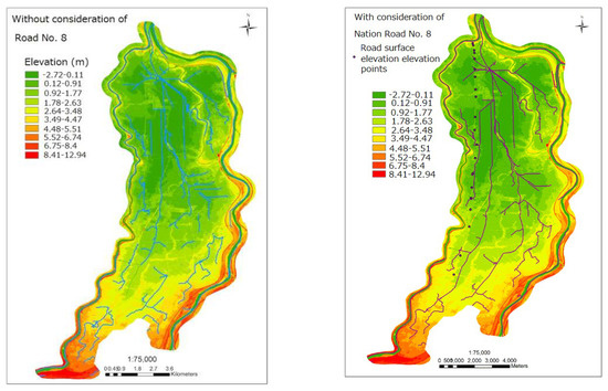
Figure 18.
Digital experiment: drainage patterns with and without consideration of National Road No. 8.
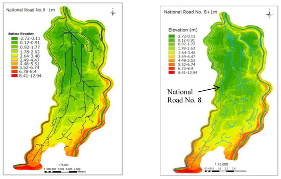
Figure 19.
Digital experiment: National Road No. 8 in Minami Ward being raised and lowered.
4. Discussion
The lessons learned from these case studies are summarized below.
- Cases 1 and 2 highlighted the need to carefully consider the safety of evacuation on foot in evacuation planning. Especially, great attention should be paid to aged people or those needing assistance in evacuation. Although the two tragedies occurred more than a decade ago, revisiting them can help raise the awareness that the safety of evacuation is still less studied than what it should be.
- Since Edogawa Ward and Koto Ward are low-lying lands, safe location within their administrative boundaries may be limited. Therefore, the so-called wide area evacuation may become necessary. To evacuate residents to a shelter out of walking distance, vehicles are needed. Cases 3–5 highlighted the fact that wide area evacuation could be hindered if main roads were flooded and designated shelters may not function due to the flooding of access roads. Case 6 pointed out the road underpass as a universal problem in road management with regard to flooding. How to secure emergency transportation roads is both a technical and social issue requiring innovation and collaboration between flood management and transportation sectors.
- The change of surface infiltration by roads is a classical and well-studied subject, however, how roads alter watershed drainage patterns remains insufficiently explored. Case 7 provided a method for a quick diagnosis on alteration of drainage patterns by roads, which can be used by urban and road planners at planning stage.
In light of the findings from these case studies, a policy framework of dialogue for improving both flood risk management and road planning is proposed (Figure 20). It consists of two pillars, as described below.
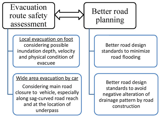
Figure 20.
A framework for dialogue between flood and road management sectors.
- (1)
- Evacuation route safety assessment: In addition to conventional 2-D overland flood inundation simulations, floodwater propagation modeling along the road network needs to be conducted for various scenarios, and the results should be used to optimize the planning of evacuation routes and shelter locations and also support real-time evacuation operations. For local evacuation on foot, depth and velocity along evacuation routes should be carefully examined with consideration of physical condition of evacuees. For wide area evacuation by vehicle, the conditions of main roads such as sag-curved reach and underpass should be scrutinized. If a safe and efficient route to a shelter cannot be found, the relocation of the shelter should be planned or engineering work should be undertaken to improve the conditions of access roads. Besides, in planning evacuation operation, the guideline for the evacuation of aged people should be prepared.
- (2)
- Better road planning: Refinement of road planning and design codes in consideration of road flooding. For example, the topic of how to avoid or reduce the flood risk in sag-curved road sections deserves serious in-depth discussion. In the meantime, because road networks may have unintended effects on surface runoff, the possible change in drainage pattern due to roads needs to be addressed and analyzed at the planning stage. Through the integration of the two pillars, the flood evacuation plan can be optimized and emergency operations can be more smoothly conducted, and better urban planning can be achieved. Overall, such a framework can promote better communication between the two sectors to minimize flood-related fatalities and property damage which is essential for sustainable development.
- (3)
- A step towards achieving such a dialogue would be the collection and in-depth analysis of more cases of mutual influence to raise the awareness of professionals in both sectors.
Nevertheless, it should be mentioned that the present study did not consider the underground drainage system. Such a treatment did not affect case studies in Group 1 and 2 since the analyses were mainly based on field data. For Group 3, the approach employed is also justifiable because road networks were often developed before the construction of underground drainage systems. It is an often-seen pattern of development. Further study will expand the framework of dialogue to include underground drainage system.
5. Conclusions
The present work showed that a lack of consideration in the flood evacuation plan with regard to evacuation safety caused deaths in the cases considered. It also revealed that in the flood-prone areas of Tokyo, evacuation shelters may be unable to function properly because of possible inundations of access roads, which has not received sufficient attention up to now in urban flood risk management. Furthermore, it explored factors affecting the vulnerability of roads to flooding, such as sag-curved road profiles and underpasses and a GIS-based approach for quick assessment of road impact on surface drainage characteristics was proposed. The most important message from these case studies is evacuation safety should be improved through better communication between flood risk and road management professionals, which in turn will lead to better road planning. Finally, it serves as a call for further in-depth study on the integration of flood risk management and road engineering sectors, which will certainly contribute to sustainable development via flood disaster reduction.
Funding
This research work was part of Sophia Research Branding Project, which was funded by Japan Ministry of Education, Culture, Sports, Science and Technology.
Acknowledgments
Thanks should be given to the Edogawa Ward and Koto Ward offices for the valuable data used in this undertaking.
Conflicts of Interest
The authors declare no conflict of interest.
References
- Queiroz, C.; Haas, R.; Cai, Y. National Economic Development and Prosperity Related to Paved Road Infrastructure. Transp. Res. Rec. 1995, 1455, 147–152. [Google Scholar]
- Yamamoto, H. Technological Innovation and the Development of Transportation in Japan; United Nations University Press: Tokyo, Japan, 1993. [Google Scholar]
- Vielhaber, M.; Kaspar, J.; Stoffels, P. Engineering for Sustainable Road Mobility. Procedia Manuf. 2017, 8, 246–253. [Google Scholar] [CrossRef]
- Böcker, L.; Dijst, M.; Prillwitz, J. Impact of Everyday Weather on Individual Daily Travel Behaviours in Perspective: A Literature Review. Transport Rev. 2013, 33, 71–91. [Google Scholar] [CrossRef]
- Koetse, M.J.; Rietveld, P. The impact of climate change and weather on transport: an overview of empirical findings. Transp. Res. D Transp. Environ. 2009, 14, 205–221. [Google Scholar] [CrossRef]
- Versini, P.-A.; Gaume, E.; Andrieu, H. Assessment of the susceptibility of roads to flooding based on geographical information—Test in a flash flood prone area (the Gard region, France). Nat. Hazards Earth Syst. Sci. 2010, 10, 793–803. [Google Scholar] [CrossRef]
- Shabou, S.; Ruin, I.; Lutoff, C.; Debionne, S.; Anquetin, S.; Creutin, J.-D.; Beaufils, X. MobRISK: A model for assessing the exposure of road users to flash flood events. Nat. Hazards Earth Syst. Sci. 2017, 17, 1631–1651. [Google Scholar] [CrossRef]
- Pregnolato, M.; Ford, A.; Wilkinson, S.M.; Dawson, R.J. The impact of flooding on road transport: A depth-disruption function. Transp. Res. Part D 2017, 55, 67–81. [Google Scholar] [CrossRef]
- Arkell, B.P.; Darch, G.J.C. Impact of climate change on London’s transport network. Munic. Eng. 2006, 159, 231–237. [Google Scholar] [CrossRef]
- Peterson, T.C.; McGuirk, M.; Houston, T.G.; Horvitz, A.H.; Wehner, M.F. Climate Variability and Change with Implications for Transport. Available online: http://onlinepubs.trb.org/onlinepubs/sr/sr290many.pdf (accessed on 27 May 2018).
- Huang, G. Does road accelerate urban flooding? J. Japan Soc. Hydrol. Water Resour. 2010, 23, 248–254. (in Japanese). [Google Scholar] [CrossRef]
- Lagmay, A.M.; Mendoza, J.; Cipriano, F.; Delmendo, P.A.; Lacsamana, M.N.; Moises, M.A.; Pellejera, N., III; NiñoPunay, K.; Sabio, G.; Santos, L.; et al. Street floods in Metro Manila and possible solutions. J. Environ. Sci. 2017, 59, 39–47. [Google Scholar] [CrossRef] [PubMed]
- Coles, D.; Yu, D.; Wilby, R.L.; Green, D.; Herring, Z. Beyond ‘flood hospots’: Modelling emergency service accessibility during flooding in York, UK. J. Hydrol. 2017, 546, 419–436. [Google Scholar] [CrossRef]
- Hamacher, H.; Tjandra, S. Mathematical modelling of evacuation problems: State of the art. In Pedestrian and Evacuation Dynamics; Springer: New York, NY, USA, 2002; pp. 227–266. [Google Scholar]
- Yang, K.; Shekhar, S. Evacuation Route Planning. In Spatial Network Big Databases; Springer: New York, NY, USA, 2017; pp. 57–72. [Google Scholar]
- Marshall, S. Streets & Patterns; Spon Press, Taylor & Francis Group: New York, NY, USA, 2005. [Google Scholar]
- Jiang, B.; Claramunt, C. A Structural Approach to the Model Generalisation of an Urban Street Network. GeoInformatica 2004, 8, 157–171. [Google Scholar] [CrossRef]
- Mesev, V. Identification and characterization of urban building patterns using IKONOS imagery and point based postal data. Comput. Environ. Urban Syst. 2005, 29, 541–557. [Google Scholar] [CrossRef]
- Barthélemy, M.; Flammini, A. Modeling urban street patterns. Phys. Rev. Lett. 2008, 100, 138702. [Google Scholar] [CrossRef] [PubMed]
- Huang, G. Characterization of flood inundation in Sanjo City, Japan on July 13, 2004. J. Hydrodyn. Ser. B 2006, 18, 295–299. [Google Scholar] [CrossRef]
- Tamura, K.; Hayashi, H.; Kimura, R. Clarifying Suffering of the Elderly in the 2004 Niigata Flood and the 2004 Mid-Niigata Prefecture Earthquake. J. Nat. Disaster Sci. 2005, 27, 67–84. [Google Scholar]
- International Federation of Red Cross and Red Crescent Societies. World Disaster Report; International Federation of Red Cross and Red Crescent Societies: Geneva, Switzerland, 2007. [Google Scholar]
© 2018 by the author. Licensee MDPI, Basel, Switzerland. This article is an open access article distributed under the terms and conditions of the Creative Commons Attribution (CC BY) license (http://creativecommons.org/licenses/by/4.0/).