Article

An Analysis of Housing Structures’ Earthquake Vulnerability in Two Parts of Dhaka City

Graduate School of Information Science and Technology, Osaka University, Osaka 565-0871, Japan
*
Author to whom correspondence should be addressed.
Sustainability 2018, 10(4), 1106; https://doi.org/10.3390/su10041106
Submission received: 2 March 2018 / Revised: 4 April 2018 / Accepted: 5 April 2018 / Published: 7 April 2018

Abstract

:
The damage done in earthquake disasters is correlated to the types of housing structures that are present. In the last two decades of urbanization in Dhaka, rapid growth without proper planning has been a major concern. This study evaluates the performance of the decision tree and random forest techniques to predict structures’ vulnerability factors for buildings as a step towards improving earthquake disaster preparedness. Applying the decision tree algorithm to locations (wards) in Dhaka North City Corporation (DNCC) and Dhaka South City Corporation (DSCC), we observed some important predictors of earthquake damage. Decision tree analysis reveals that the most important predictor for structures that fare well in earthquakes is the use of reinforced concrete, and a common factor among the most vulnerable structures is the soft story building style in the DNCC and DSCC areas. The random forest technique also showed reinforced concrete as being the most important factor for lowering the risk for housing structures, with the model having a 24.19% out-of-bag (OOB) error. As for vulnerability, soft story construction was a significant factor in estimating earthquake susceptibility (40.32% OOB error). The findings reveal that building materials in the DNCC are stronger than those in the DSCC but soft story buildings are more common in the DNCC, which make it one of the weakest parts of the area and point to the need to make plans to seismically retrofit soft story buildings.

1. Introduction

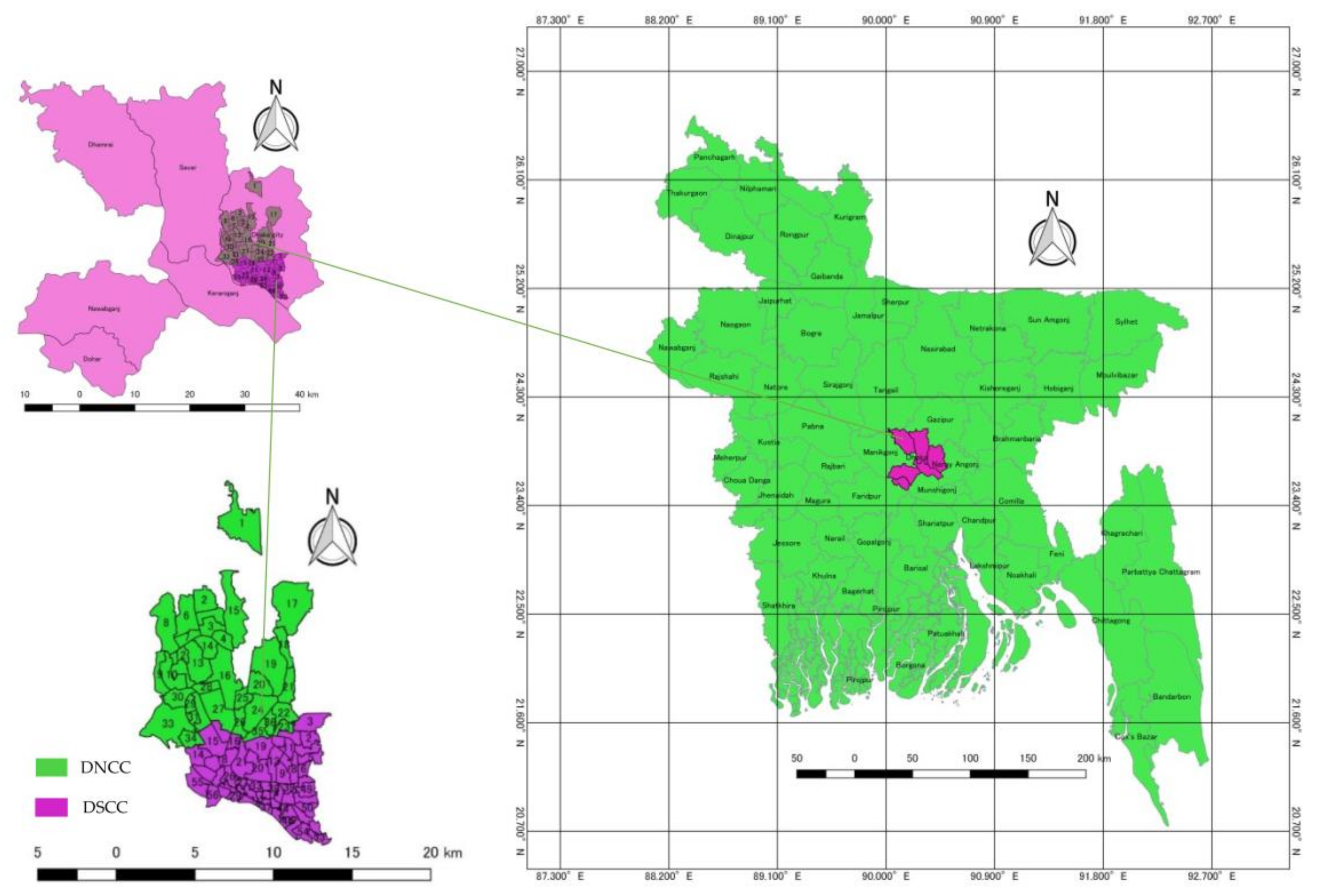
The capital city of Bangladesh is Dhaka, which has become one of Earth’s megacities. The urban center is administered by the Dhaka City Corporation (DCC) which is split into two administrative parts, the Dhaka North City Corporation (DNCC) and the Dhaka South City Corporation (DSCC), in order to offer better facilities (see Figure 3). The DCC, which is the prime city in Bangladesh, covers an expanse of 321 km2 and has a population of over 14 million. Dhaka city’s history began about 400 years ago, and has proceeded without proper planning, constructed in a non-directed manner. The maximum number of buildings, both engineered and non-engineered, have been established on the artificial sand pilings along the recent floodplains of the Buriganga, Turag, Balu and Sitalakhya Rivers [1]. Most buildings were erected without the oversight of a proper earthquake disaster prevention system [2]. Collective consciousness regarding this problem has risen among some limited groups, but, practically, city dwellers and policy makers are not sufficiently aware of their seismic vulnerability. Nevertheless, the extent of seismic vulnerability can be minimized if the necessary steps are taken for the least earthquake-resistant buildings, since earthquakes themselves do not injure and kill people, it is the hazardous buildings that do. Thus, there is a great need for judgment regarding which of the huge number of existing buildings are more vulnerable to quakes. Most buildings have reinforced concrete frames with masonry infill. Many exhibit improper design or construction practices like the inclusion of soft stories. Several structural features are recognized as seismic vulnerability factors in buildings, including soft stories, heavy overhangs, short columns, the possibility of pounding between adjacent buildings, visible ground settlement, and topographic effects [3]. When soft story mechanisms are present, reinforced concrete buildings in ground floor columns did not perform well, causing the partial or full collapse of the building structures. Unreinforced and unconfined masonry buildings have a history of inferior performance during strong earthquakes and are responsible for most of the partial and full building collapse [4]. Non-reinforced masonry structures are among the most vulnerable patterns of the building during an earthquake. When such a masonry structure is subjected to lateral inertial loads during an earthquake, the walls develop shear and flexural stresses. The strength of masonry under these conditions often depends on the bond between stone and mortar (or brick and mortar). This bond is often very poor when lime mortars or mud mortars are used [5]. Massive losses of both human lives and properties from the Nepal earthquake in 2015 demonstrate the need to strengthen masonry structures due to their poor seismic performance, as indicated by their inherent brittleness and low tensile strength [6]. Seismic retrofitting is a typical example of a pre-disaster and earthquake-specific hazard mitigation measure, but its implementation is relatively difficult [7]. Seismic retrofit is applied to many Japanese buildings designed according to old seismic codes predating the major seismic code revision of 1981 [8]. The reduction of structural vulnerability, introduction of solid ground-use rules and intent and construction regulations, relocation of communities, and use of public education awareness programs can help to mitigate earthquake risk [9]. Recently, earthquakes urban areas in Bangladesh have highlighted the urgency of pushing to strengthen these seismic deficient structures and making progress in developing various strengthening and rehabilitation techniques to boost structures’ seismic performance [10].

1.1. Earthquake Vulnerability of Dhaka’s Housing Structures

Housing is essential for human beings, and there is a great need to promote the improvement of living facilities, supplementary services and community facilities. From ancient times, humans have founded settlements in Bangladesh. Building design and housing patterns in these settlements have developed and adapted to environmental, economic and social needs, and this has been guided by climatic and geographical factors [11]. A strong earthquake affecting a major urban center like Dhaka, Chittagong or Sylhet may damage or demolish housing constructions and could be fatal for the entire nation. Even a small to moderate earthquake could cause severe damage to life and property, exceeding what the Dhaka City Corporation can currently handle [12]. It is imperative to place the highest priority on recognizing the existence of the hazard and identifying vulnerable areas [13]. Understanding disaster risk management holistically, focusing on all of its components, can allow us to see how a broad range of fields, including engineering science, development, government, risk management, risk communication, and local capacity can influence risk [14]. If an earthquake causes fault movement on the earth’s surface and then creates severe ground shaking, which in turn causes buildings to collapse (as has been the case after each disastrous earthquake), the results in terms of loss of human life can be devastating [15]. Several hazards arising in an earthquake’s aftermath may cause additional injury and loss of life and increase economic losses. In Dhaka, hazard incidents related to earthquakes seem particularly to include fire and debris generation [16]. The main negative impact of quakes is the full or partial collapse of buildings in which people may be crushed or trapped. The situation becomes particularly difficult in multi-level buildings, specifically those constructed from heavy materials such as brick and concrete. Some houses in slum areas in Dhaka are built of lightweight materials such as sheeting, timber and bamboo and are usually one to two stories high. These types of houses do not pose a very high risk of killing or seriously injuring people in an earthquake. Yet, increasingly, brick is being used to build the walls of homes in slums. It is frequently poorly designed and lacks reinforcement, and homesteaders occupy old dilapidated buildings. Such buildings pose a high risk in strong earthquakes [15]. Unreinforced masonry buildings perform poorly in earthquake movement because of their inherent brittleness, lack of tensile strength, and lack of ductility. In other words, they lack the properties provided by the steel reinforcement in reinforced masonry. Under earthquake forces, when a gap occurs in masonry, consequent earthquake pulses can trigger uncontrolled displacement, resulting in partial or total collapse of masonry units or walls. In most of these events, demolition and replacement of the masonry structures are not possible for various reasons, like orders for preservation of buildings of historic importance, or the fact that the damaged buildings serve as dwelling places in poor communities, etc. [3]. An earthquake event has more catastrophic effects in densely built settlements; thus, managing a disaster situation with the limited medical care and emergency response capabilities in Dhaka city would be difficult [17]. Therefore, it is significant that the government recognizes how to encourage households to be involved in preparing for earthquakes [18].

1.2. Earthquake Concern in Dhaka

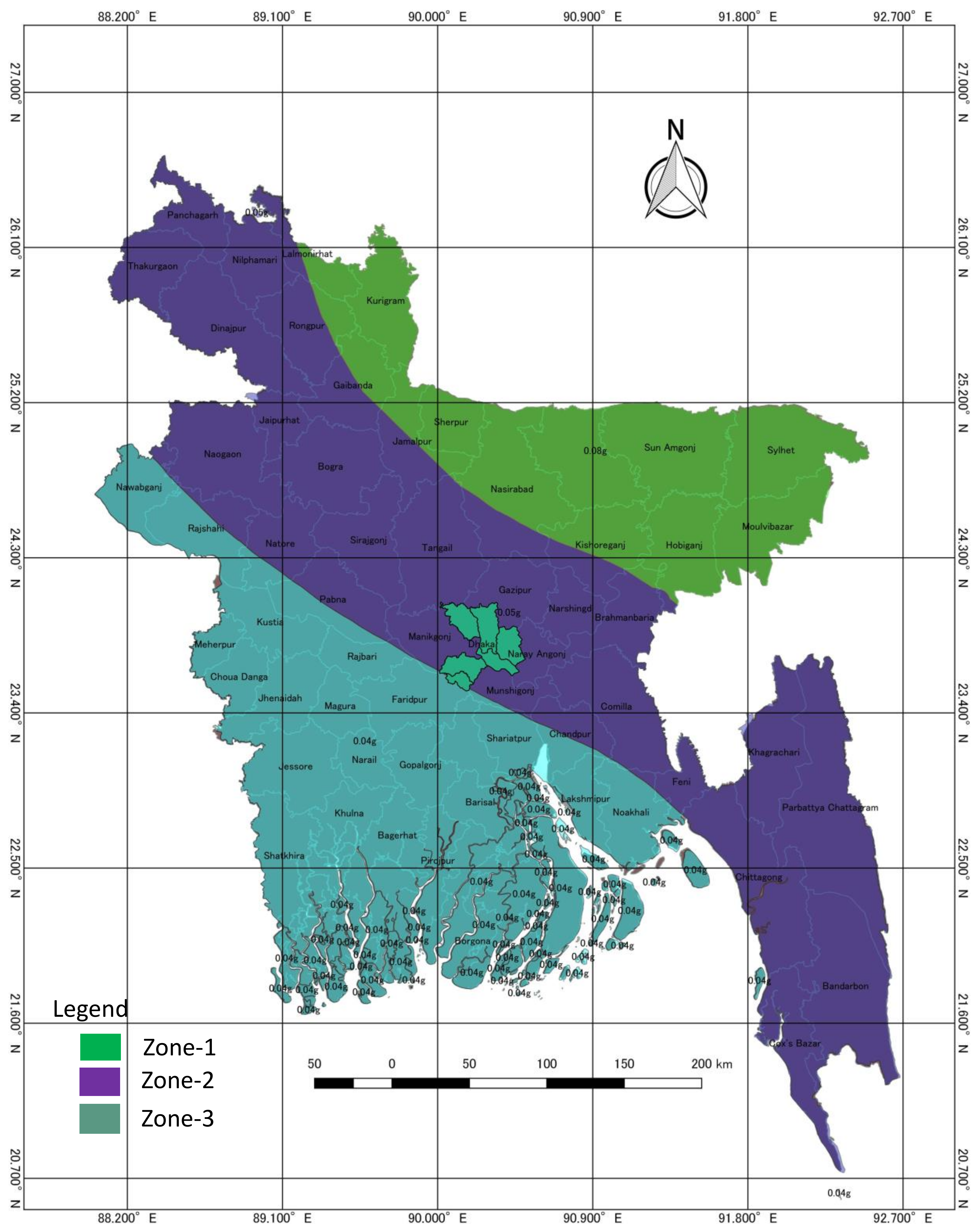
The absence of strong earthquakes in Bangladesh for more than 80 years has left the present generation unaware of the possibility of a severe earthquake. As a natural result, many buildings in the cities of Bangladesh were not designed to resist earthquakes. There is universal consensus among national and international experts about the potential for a large magnitude earthquake happening in the area at any time because of stress buildup in fault systems caused by the northward drift of the Indian Plate. Assessment of seismic risk is a primary priority for the country. To this end, studies are striving to assess hazards and to determine measures for mitigating them based on the degree of risk they are estimated to pose [19]. Bangladesh’s seismic hazard zoning map (see Figure 1) is divided into three seismic zones with seismic coefficients of 0.04 g, 0.05 g, 0.08 g (g = acceleration due to gravity). Dhaka lies in the 0.05 g zone while the northwest has the highest hazard risk [20]. Earthquake risk increases towards the north and east, creating a seismic threat in all parts of the state. The five fault lines that lie under Bangladesh are presented in Table 1 [21].
Occurrences of small-magnitude earthquakes near Dhaka Megacity and other seismogenic evidence suggest that continuing activity on these faults may produce a substantial earthquake. Assessing the exposure of Dhaka Megacity to an impending earthquake is essential [22].
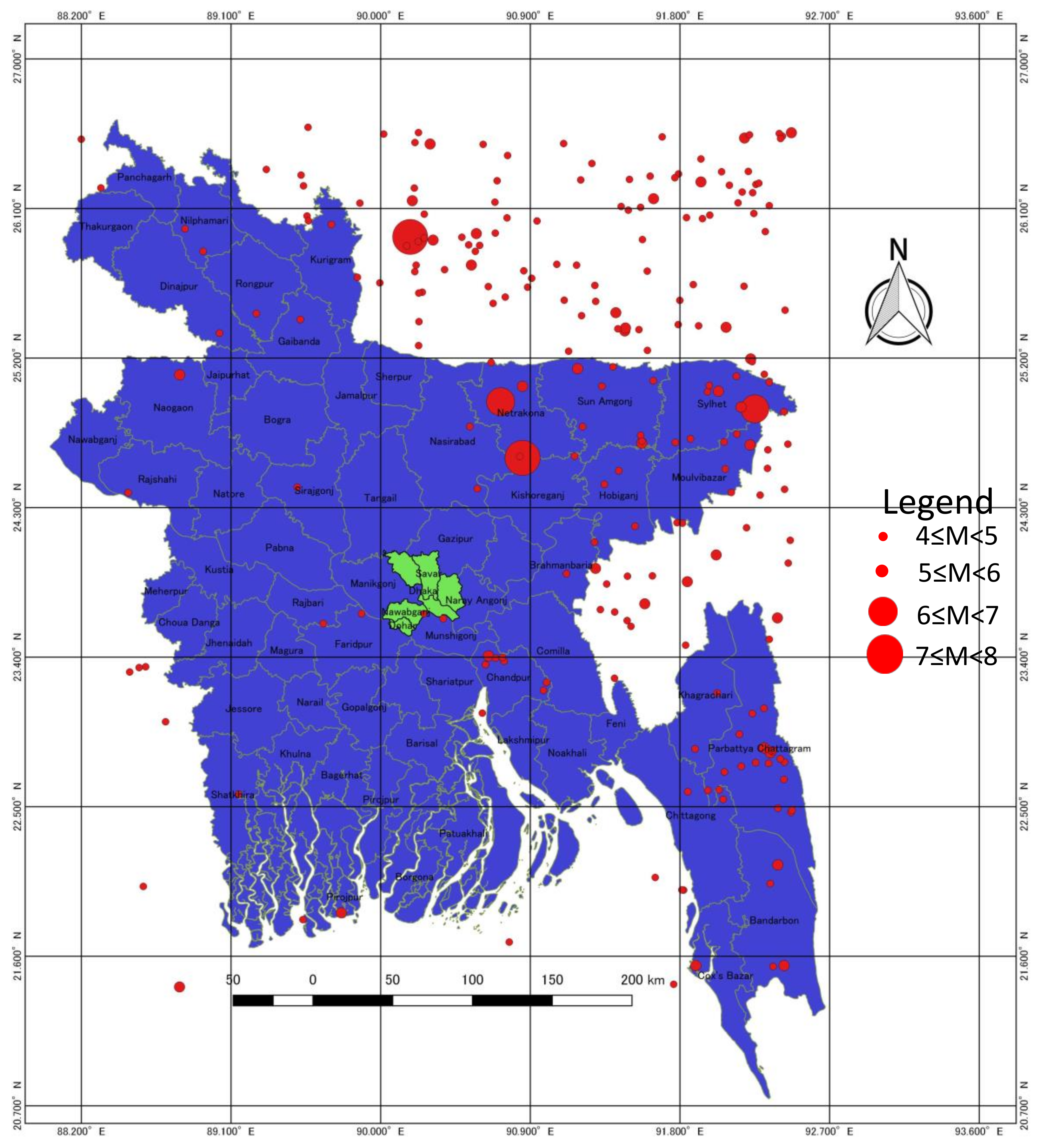
The building stock in Dhaka is susceptible to collapse by ground shaking or simply due to gravitation because of inadequate enforcement of building code regulations and the absence of robust construction standards. Its vulnerability is intensifying due to rapid urbanization and increasing pressure on land, which are making Dhaka the most densely inhabited city on the globe. Historical records (see Figure 2) from 1918 to 2018 (January) in and around Bangladesh (from 21.24° to 26.6° latitude and 88.06° to 92.483° longitude) show 236 earthquakes of magnitudes ranging from 4 to 8 [23].
Due to insufficiently developed infrastructure and preparedness in Chittagong and Dhaka, the results of a repeat of the AD1762 earthquake would be devastating [24]. The total population and population density in Dhaka and Chittagong have risen at least tenfold since the first census in AD1872 to the most recent in AD2011 [25,26,27]. A fuller understanding of the expected overall seismic performance of code-compliant buildings is required to minimize the disaster [28]. The building inventory in Dhaka city is classified into two groups: unreinforced brick masonry (URM) buildings and reinforced concrete (RC) buildings. URM buildings have been noted to have very poor seismic resistance and they can be even more dangerous if they are four or more stories high, or are built on five-inch walls, which is not uncommon in Dhaka. RC construction can also be vulnerable if earthquake-resistant design provisions are not employed. This has been fully evident in recent earthquakes in Bhuj and Izmit [29].
Recent events serve as shocking indicators of the extreme vulnerability of the constructed environment in Dhaka. One example is the collapse of the Rana Plaza building in Savar on 24 April 2013 and the deaths of the 1127 people it caused, which was deadliest event recorded in a serial publication of structural failures in the metropolis. A report commissioned by the Ministry of Home Affairs concluded that poor site location, sub-standard building materials, and illegal construction were responsible for this collapse [21]. This dreadful incident received worldwide attention and brought forward diverse issues concerning millions of workers, employers, brands and consumers—the entire supply chain in the ready-made garments sector (RMG) of Bangladesh [30]. Such buildings are evidence of a poor infrastructure that needs to be boosted to make sure structures are resilient through a variety of different initiatives [31]. To mitigate earthquake damage, we need to ensure the safety of structures under earthquake loading. Dynamic effects have been brought into consideration in design codes of many nations around the globe, often using zoning maps based on geological assessments of seismic hazards, which are embodied in construction codes or regulations [32]. Thus, it is significant that the government recognizes how to deftly encourage households to be involved in preparing for earthquakes [18].

1.3. Dhaka North City Corporation (DNCC)

In 2011, the government divided DCC into Dhaka North City Corporation (DNCC) and Dhaka South City Corporation (DSCC) through the local government amendment act 2011. The DNCC consists of 36 wards (see Figure 3), covering approximately 95.76 square kilometers, with a population of almost 3.74 million [25,33]. The DNCC is an essential part of the Dhaka megacity, having its own administration, and is a familiar institution of recent Dhaka. During the last forty years, the city has undergone rapid, radical change, not just in its physical shape, but also in terms of its internal physical workings. The DNCC consists of plots, open places, rural agricultural spaces, low ground, water bodies, parks that have been transformed into building areas, places for commercial structures, built-up land, and so on [34].

1.4. Dhaka South City Corporation

The DSCC consists of 56 wards (see Figure 3), covering approximately 44.6 square kilometers, with a population of almost 2.8 million. Its 56 wards cover Azimpur, Magbazar, Malibagah, Motijheel, Jatrabari, Kotwali, Sutrapur, Bangsal, Wari, Gendaria, Lalbagh, Hazaribagh, Dhanmondi, Shahbagh, New market, Khilgaon, Kamrangirvhar and other areas [25,35]. Natural disasters like earthquakes will probably cause catastrophic effects in the old parts of Dhaka because people will either be inside the remains of a tumbled building or will not be able to reach any post-disaster shelters. This total area is void of proper open spaces, and public buildings are in very indigent condition, so people there would have no suitable option for post-disaster shelters [31]. Old Dhaka is at high risk of earthquake disaster because of the obsolete and dilapidated building structures in which many people live. In addition, unauthorized high-rise buildings are a massive threat for those dwelling in them. Because of the multipurpose uses of its buildings and the presence of flammable substances, the vulnerability of the Shakhari Bazar (DSCC wards 35 and 36) is higher than that of the Segunbagicha (DSCC ward 20) and Uttara areas (DNCC ward 1). On the other hand, Uttara is less vulnerable than Segunbagicha with respect to multipurpose buildings. Building structures in Shankhari Bazar are mostly centuries old. Half of the buildings are at least 51 years old and five percent are almost 350 years old. In contrast, in Segunbagicha and Uttara, most of the buildings are less than 10 years old [36]. In addition, the densely built city fabric, consisting of vulnerable aged and unreinforced masonry buildings and narrow streets, makes it more vulnerable to earthquakes. A socioeconomic survey of 210 households was conducted in what was previously ward 68 (current DSCC ward 32) of the older part of Dhaka city to estimate social vulnerability and to delineate existing conditions in the target area. The socioeconomic status of the study area illustrates that the area is in between the low and middle-income groups, and if a disaster struck in this area, most of them would suffer losses. The expected loss is unpredictable and financial assistance would be required from outside individuals, governments and foreign agencies [37]. A recent building survey funded by the Bangladesh Ministry of Science and Technology research grant, conducted in parts of Sutrapur, Lalbagh and West Dhanmondi (in the DSCC) reveals a concentration of multi-storied URM buildings in the older part of the city. While the percentage of URM buildings in the Sutrapur area of the old city was found to be roughly 65%, in the relatively new West Dhanmondi area, it was approximately 42% [29]. The earthquake performance of cities can be upgraded by changing their functional characteristics through urban transformation, land-use planning, and boosting the quality and redundancy of the infrastructure [9]. This will require careful coordination between different groups such as the police, armed forces, volunteers, professionals, engineers, firefighters, rescue personnel, utility personnel, medical personnel, media, social workers and post-disaster relief personnel [29].

2. Materials and Methods

2.1. Data Sources and Selection of the Research Area

The Comprehensive Disaster Management Program (CDMP) started in 2009 by the government of Bangladesh is being implemented by the Ministry of Food and Disaster Management. The CDMP has assigned the Asian Disaster Preparedness Center (ADPC) responsibility for mapping seismic hazard and vulnerability in and around Dhaka city. This data is publicly available in the Earthquake vulnerability assessment of Dhaka, Chittagong and Sylhet City Corporation. In this research, we chose the variables, one of which was structural type, which includes: reinforced concrete (RC), lightly reinforced concrete (LC), masonry brick in cement mortar with a concrete floor (BC), masonry brick in cement mortar with a flexible roof (BF), and tin shed bamboo (TSB). For building age, we categorized three age groups: less than 10 years, 10–30 years and over 30 years. Finally, for earthquake vulnerability factors we chose: the presence of a soft story, the presence of a heavy overhang, pounding between adjacent buildings, and topographic effects.
Dhaka city is divided into two parts, Dhaka North City Corporation (DNCC) with 36 wards (excluding the airport and cantonment area due to restrictions) and Dhaka South City Corporation (DSCC) with 54 wards (wards 55 and 56 were not included because the data was not available). These divisions are followed in this study. They cover 136.4 km2 and comprise all 90 wards of the DCC.

2.2. Data Analysis and Mapping

The numeric values for structural type, building age and earthquake vulnerability factors are independent variables. Whether or not a structure is in the DNCC or DSCC was input as a categorical variable in the R programming for data analysis and for mapping using QGIS software. This research applied a machine-learning decision tree algorithm and a random forest algorithm to predict which parts of the DCC are most vulnerable to earthquakes. The main advantages of the decision tree and random forest techniques for predicting grouped or multiple variables that we applied in this research are that they produce easily understandable results for any city as to which parts are more vulnerable to earthquakes and that readers can reproduce the analysis. The authors prepared all of the maps using of shape files in QGIS software.

2.3. Decision Tree

A decision tree is a graph that uses a branching method to demonstrate every possible outcome of a decision. Decision trees can be drawn by hand or created with a graphics program or specific software. Programmatically, they can be used to assign monetary/time or other values of possible outcomes so that decisions can be automated. Decision trees are used in data mining to simplify complex strategic challenges and variables into a form normally denoted by circles. Decision trees are easy to understand and can be used to classify both categorical and numerical data, but the output attributes must be categorical [38]. Each categorical predictor is inputted into the model as a single entity and the model decides how to group or split the values. Initially, all categorical predictors are decomposed into binary variables. These binary variables are considered independently, thus forcing a binary split into the categories [39]. The best variables are selected to split the categories, and the decision tree also defines cut-off levels or rules and the split accordingly. This process is applied recursively to the subgroup until the decision tree is finished, as defined by various stopping criteria [40].
In both our decision tree and random forest analyses, we took the wards of the DNCC and DSCC as the response variable for all of the models, and the predictor variables are the housing structure type, building age and vulnerability factors. The analysis was done using R studio. To examine the earthquake vulnerability of Dhaka city’s housing structures, we categorized them into reinforced concrete buildings, lightly reinforced concrete buildings, masonry brick in cement mortar with concrete floors, masonry brick in cement mortar with flexible roofs, and tin and bamboo sheds as explanatory variables. Building ages were grouped into those built less than 10 years ago, those that are 10 to 30 years old and those over 30 years old as an independent variable in order to see the role building age plays in earthquakes. Finally, earthquake vulnerability factors such as soft stories, the presence of heavy overhangs or short columns, pounding of adjacent buildings, and topographic effects were used as predictors to tell which factors most effect vulnerability. For the decision tree analysis, we partitioned our dataset into 80% for the training set and 20% for the validation set. We used data from 76 wards for training data and 14 wards for validation data.

2.4. Random Forest

Random forest is a new entry in the field of data mining and is designed to produce accurate predictions that do not over fit the data. Random forest is an ensemble of unpruned classification or regression trees, induced from bootstrap samples of the training data, using random feature selection in the tree induction process [41]. For the random forest technique, a total of 36 wards in the DNCC and 54 wards in the DSCC were divided into two groups, training (70%) and testing (30%) respectively. Training sets were used to construct the random forest classification model, while test sets were selected to be used to verify the performance of the constructed model.

3. Results

3.1. Decision Tree

3.1.1. Housing Structure

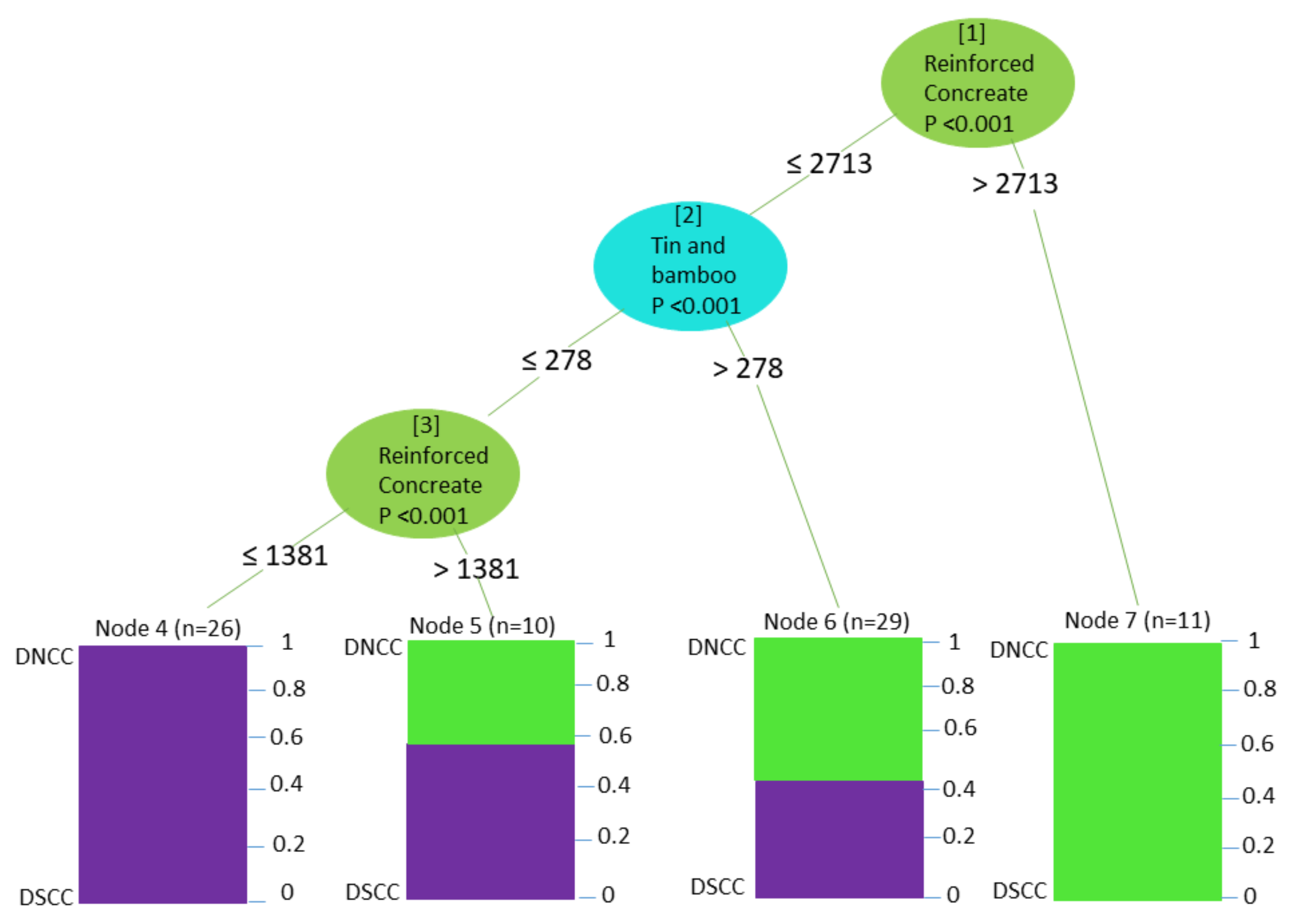
From our training data, we can see (Figure 4) that the most important predictor of the variation in this model is reinforced concrete buildings (RC). Starting at node 1, if the number of RC buildings is less than or equal to 2713 and the number of tin and bamboo sheds (TSL) is less than or equal to 278, proceed to node 3. Then if there are 1381 or less RC buildings, go to node 4 where 26 wards were predicted accurately within the DSCC. Wards in node 5 area predominately in the DSCC, while those in node 6 were predominately in the DNCC. In those wards, there are more than 2713 RC buildings. Eleven wards in the DNCC were predicted accurately here. Our validation data correctly predicted 12 out of 14 DNCC wards with only two wards being predicted as belonging in the DSCC.

3.1.2. Building Age

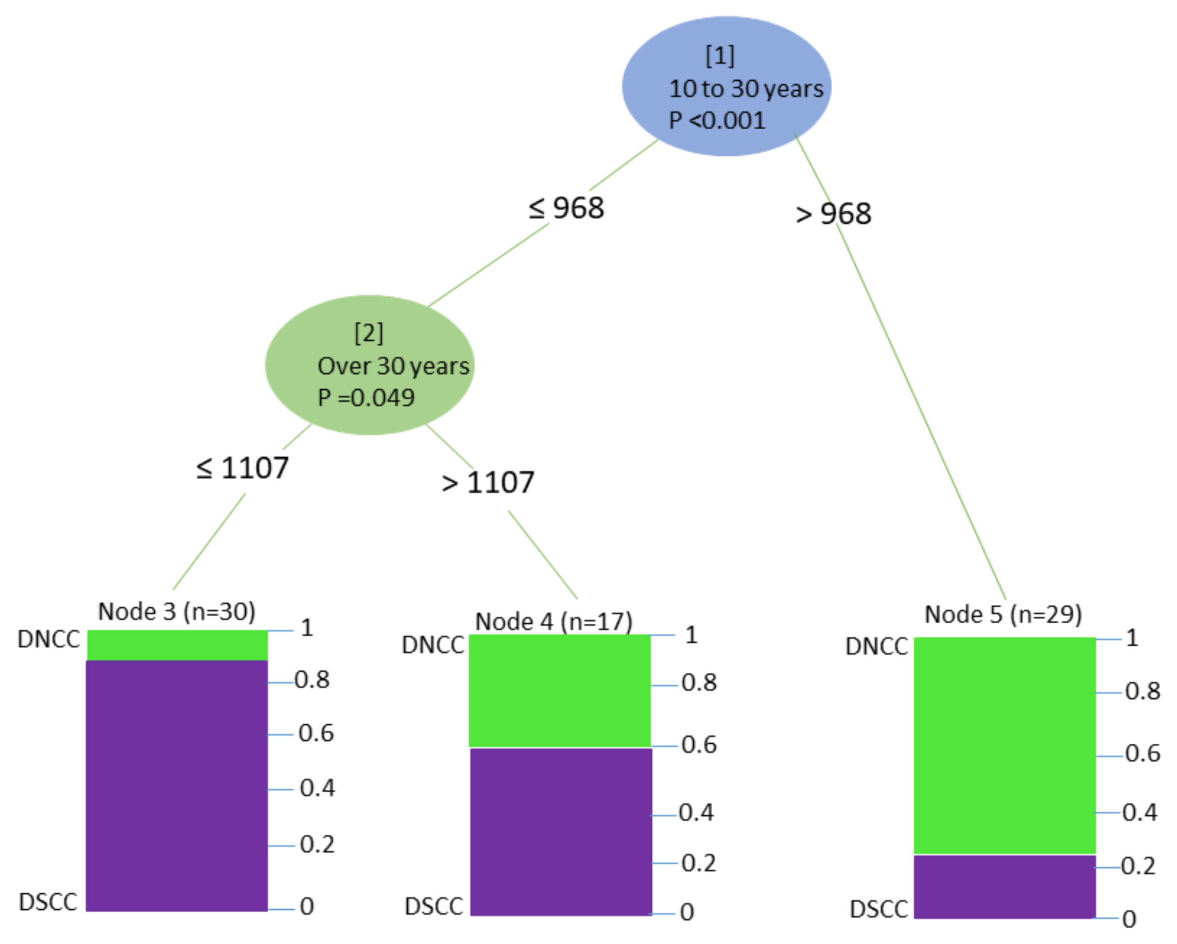
In this case (see Figure 5), if there are more than 968 buildings that are 10 to 30 years old, then go to node 5. This accurately predicts 75% of the 29 wards in the DNCC. If there are fewer than 968 buildings of that age, then move to node 2. If there are 1107 or fewer buildings over 30 years old, move to node 3. The algorithm correctly then predicts about 90% of the 30 DSCC wards. From the validation data, seven of the 14 wards were predicted to be in the DNCC and seven were predicted to belong in the DSCC.

3.1.3. Earthquake Vulnerability Factors

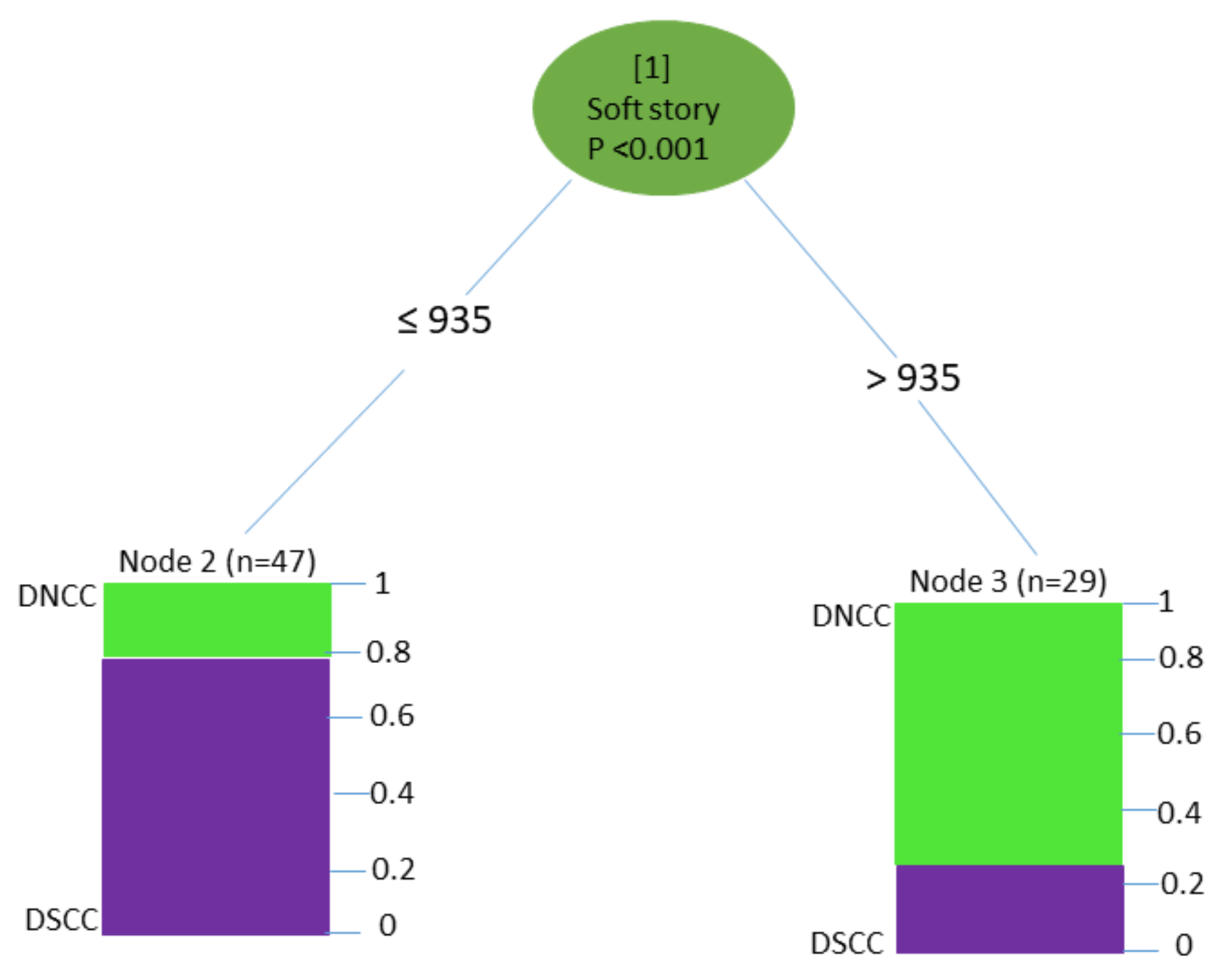
The most significant predictor (see Figure 6) here is the presence of a soft story. If there are fewer than 935 soft story buildings, go to node 2 where 80% of 47 DSCC wards were predicted accurately. However, if there are more than 935 soft story buildings, then we go to node 3, where 75% were classified as being in the DNCC. We can predict from our validation data that out of 14 wards, six wards are predicted to be in the DNCC and eight are predicted to belong in the DSCC.

3.2. Random Forest

3.2.1. Housing Structure

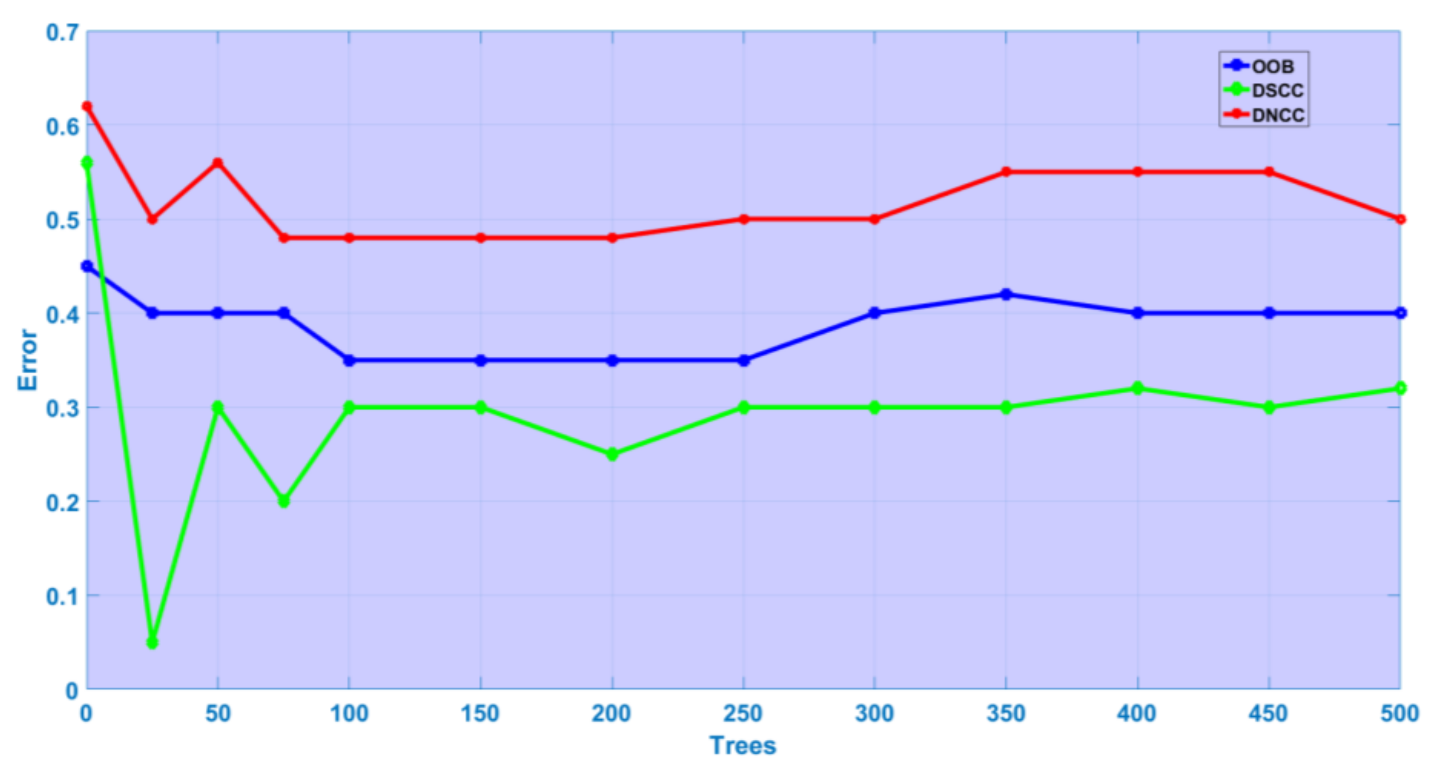
The out-of-bag error (OOB) suggests that, when the resulting model is applied to new observations, the answer will be in error 24.19% of the time. This indicates that 75.81% of the results are accurate, which would indicate a reasonably good model. We observed that, of the 30% of the data set aside for testing from the confusion matrix (28 wards), six wards from DNCC and 13 wards from DSCC were classified correctly. The accuracy of the random forest model for the test data was 0.6786.
Figure 7 shows that, in the initial stages, errors were higher, but as the number of trees increased, they dropped slowly overall.
The random forest technique offers a simple way to measure variable importance for each of its features, affording insights into the interaction between those features and the model’s prediction accuracy. Variable importance is a measurement of how much influence an attribute has on prediction accuracy. There are two methods of measuring it in a random forest: Gini importance and permutation importance. A list of important variables in the model represents each class of activity. The importance of the variables considered, based on the mean decrease in the Gini index, is presented in Table 2.
The most important attributes are of reinforced concrete buildings and tin and bamboo mixed structures, which carry the most influence in the model.

3.2.2. Building Age

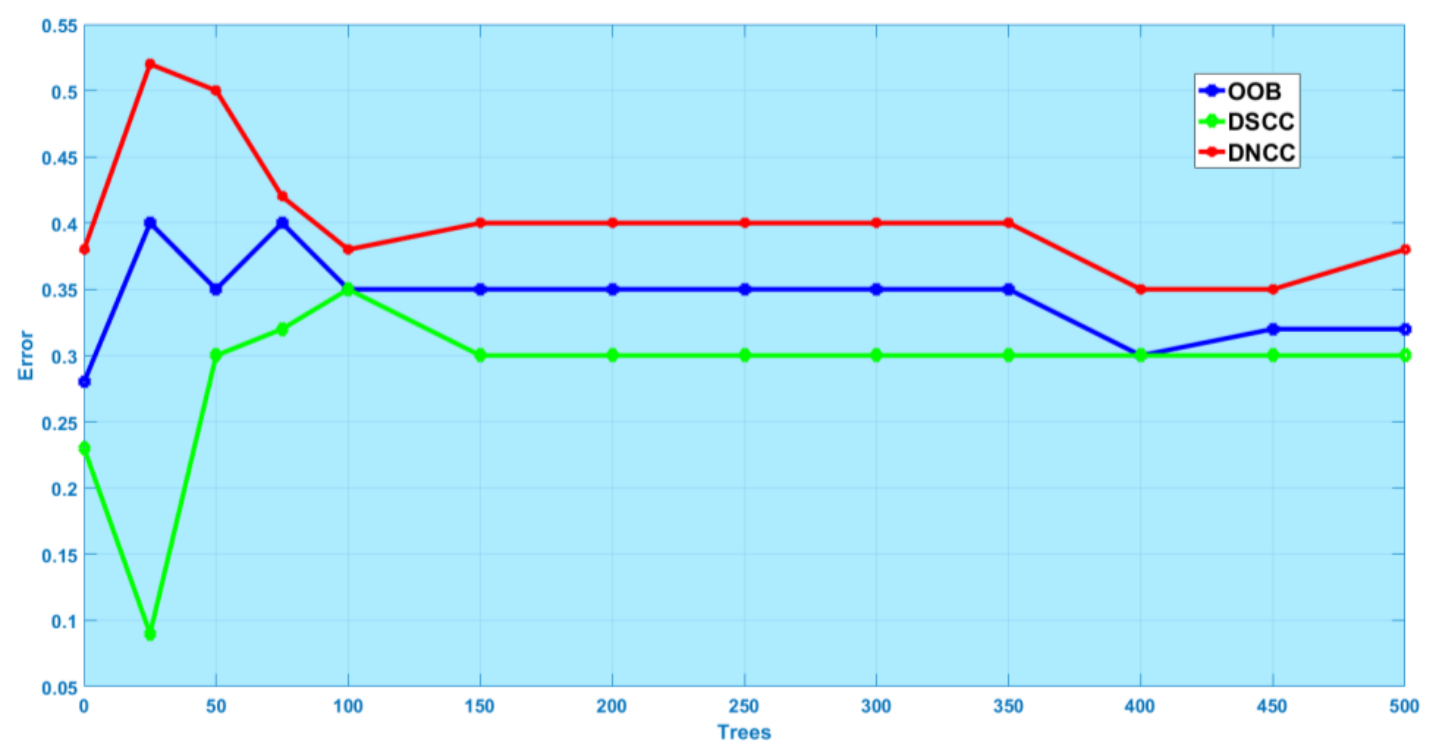
The OOB, as presented in Figure 8, suggests that when the resulting model is applied to new observations, the answer will result in an error 32.26% of the time. This indicates that 68.74% of the results will be accurate, which would indicate a reasonably good model. Out of the 30% of the data set aside for testing, (28 wards), seven wards from the DNCC and 13 wards from the DSCC are classified correctly, implying an accuracy of 0.7143 on the test data. A list of the modelled categories is shown in Table 3. The building age range of 10 to 30 years is the most important.
Figure 8 indicates that, as the number of trees increases, the OOB error rate decreases, particularly in the DSCC, and after 200 trees the OOB error rate becomes constant. The DNCC OOB error rate still fluctuated slightly after 400 trees, becoming stable after 450 trees.

3.2.3. Earthquake Vulnerability Factors

The OOB error for these factors suggests that when the resulting model is applied to new observations, the answer will result in an error 33.87% of the time (66.13% accuracy, indicating a reasonably good model). Here, we can see that, out of the 30% test holdout data for 28 wards, seven wards from the DNCC and 10 from the DSCC are classified correctly, and the accuracy of the random forest model on the test data is 0.6071.
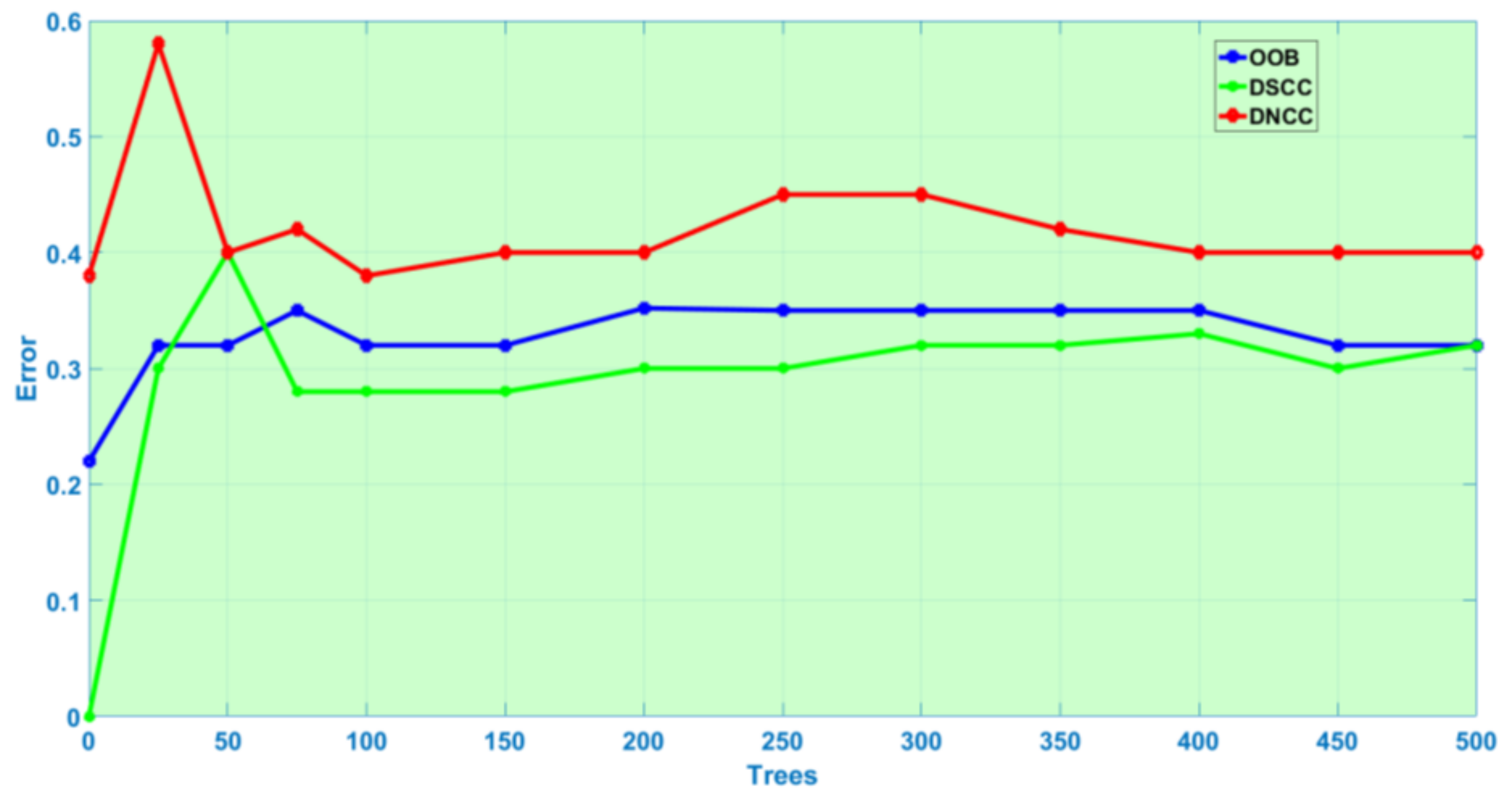
As shown in Figure 9, the final random forest model was built from 500 trees. The OOB error rate decreased quickly as the number of trees increased up to 350. After that, the error rate becomes constant. As described in the discussions above of variable importance for building age and structure type, for vulnerability factors, we found the presence of short columns and heavy overhangs to have the most influence in the model (see Table 4).

4. Discussion

4.1. Structural Type

Reinforced concrete (RC) structures are built of concrete, which responds rather weakly to tensile forces and is quite brittle. These structures are enhanced with a reinforcement of higher tensile strength and/or ductility. RC is concrete that is made with pieces of metal inside it to make it stronger. Reinforcing schemes are usually designed to resist tensile stresses in particular regions of the concrete that might cause unacceptable cracking and/or structural failure. Modern reinforced concrete can include varied reinforcing materials made of steel, polymers or alternate composite material along with its standard rebar. RC may also be prestressed to improve the behavior of the final structure under working loads [42].
In the last twenty years, urban development has sparked a widespread construction boom in the DNCC, and very recently new high-rise buildings and skyscrapers have changed Dhaka’s Northern landscape. Different real estate companies have constructed a variety of high-rise apartment buildings either by purchasing land from the owners or demolishing existing one- or two-story buildings [43]. However, inadequate infrastructure and the existence of many vulnerable buildings has resulted in a serious threat of collapse in old areas of Dhaka (DSCC) [31].
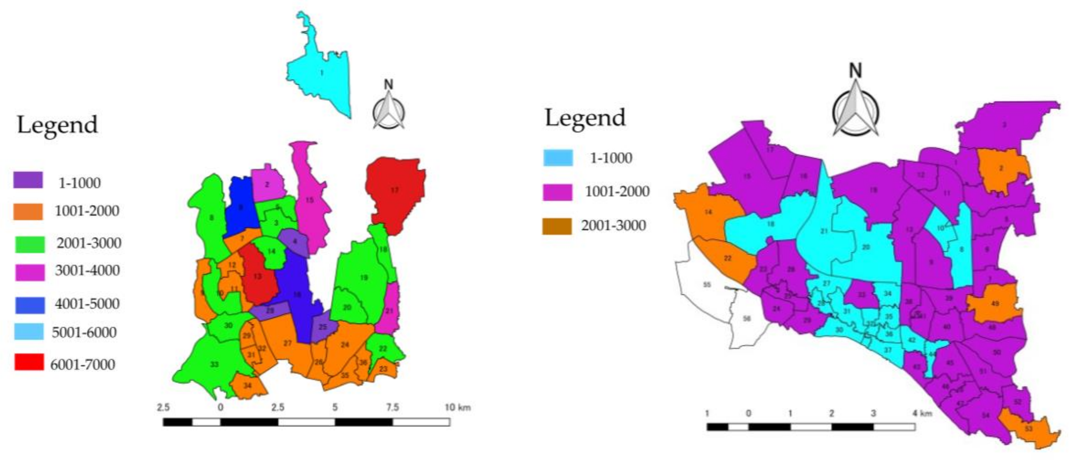
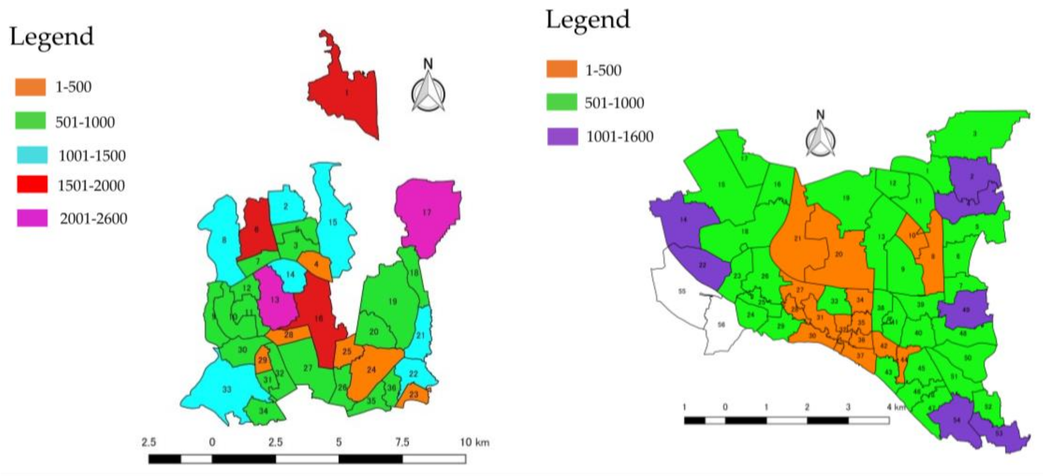
Our study reveals (see Figure 4 and Table 2) that for structure type, the presence of reinforced concrete buildings is the most important predictor. These are more common (see Figure 4 and Figure 10) in the DNCC, which can tolerate small or medium earthquakes. In the DSCC, on the other hand, less than half the buildings in an area are likely to be RC-type structures. Therefore, the DSCC is much more vulnerable to earthquake disasters with respect to housing structure types. Still, we highly recommend applying seismic retrofits in both areas to mitigate earthquake disasters.
Lightly reinforced concrete buildings (LC) are the RC structures that employ only the minimum structural members to sustain gravity loading. The columns in these buildings are small and they have heavy overhangs [12]. Lightly reinforced concrete columns are common in many old buildings and are widespread in current detailing practice in areas with lower seismicity. From a conventional design perspective, this structural type has very low lateral load and drift capacity.
Masonry brick in cement mortar with a concrete floor (BC) buildings have concrete slabs, structural masonry walls and no confined reinforced concrete columns [12]. The concrete used in these buildings is made by mixing cement, sand, small stones, and water. Its stability and durability, which varies widely, can also be a liability, and concrete floors are very hard. Many masonry buildings that have been subjected to catastrophic earthquakes have collapsed or suffered severe damage due to inappropriate design, improper material production or application mistakes. Nevertheless, many masonry buildings, particularly historical ones, have survived earthquakes with little or no damage, while many new reinforced concrete structures in the same location have been cracked or heavily damaged. Therefore, if masonry buildings can be designed to resist earthquake and constructed with excellent quality materials, they could survive earthquakes. Although masonry buildings vary in different earthquake zones, the damage they suffer from earthquakes can usually be classified [44].
Buildings in the masonry brick in cement mortar with a flexible roof (BF) category are quite similar to those with concrete floors. However, due to the lack of a stiff diaphragm that confines the masonry wall, they exhibit poorer seismic behavior [12]. Flat roofs exist all over the world and each area has its individual traditional or preferred materials. In warmer climates, where there is less rainfall and frost is unlikely, many flat roofs are simply made of masonry or concrete, which is inexpensive, good at shielding the warmth of the sun and easy to build [45].
The tin shed bamboo (TSB) category ranges from very simply constructed open-sided tin roofed structures to large wood or bamboo-framed sheds with shingled roofs, windows and electrical outlets. Tin shed construction may have metal or plastic sheathing over a metal frame. Tin sheds and bamboo houses are less vulnerable to earthquakes.
We also discovered (see Figure 4 and Table 2) from the decision tree and random forest analysis that, after RC buildings, TSB structures are the second most important predictor for earthquake hazard, and performed better in the DSCC area than in the DNCC area. One essential factor here is that these types of house are not built adjacent to other structures, avoiding the indirect effects of contact during earthquakes.

4.2. Building Age

Building age is divided into three categories as follows: (1) less than 10 years old; (2) 10–30 years old; and (3) over 30 years old. Buildings from the last 10 years are new. Particularly, in recent years real estate companies have built many residential buildings. The many buildings from 10 to 30 years old are also part of Dhaka’s building boom of the last two or three decades. Our results (see Figure 5 and Table 3) reveal that having buildings from 10 to 30 years is the most important predictor. This was particularly significant in the DNCC since these buildings are less vulnerable than those over 30 years old. These newer buildings (see Figure 11) are more common in the DNCC than in the DSCC.
Buildings constructed more than 30 years ago are quite old and were designed without earthquake engineering considerations, so are more vulnerable to earthquakes. Some of the urban areas in Old Dhaka (DSCC) are several hundred years old and the people living in them are at risk of the closely-packed, congested buildings being obliterated [31]. We found that Old Dhaka (DSCC ward 32) was emphasized by the maximum number of respondents having aged and/or damaged buildings [37].
The result reveals that buildings over 30 years old, having aged and not having been engineered correctly in the first place, are more vulnerable during earthquake events. From our analysis (see Figure 5), there are more of these buildings in the DSCC than in the DNCC. We, therefore, recommended that design and constructed methodologies be upgraded to improve these outdated buildings and mitigate earthquake disasters, particularly in the DSCC.

4.3. Vulnerability Factors

According to level 1 of the Turkish method for earthquake disaster abatement, there are five factors that affect a structure’s vulnerability: a soft first story, heavy overhang, short columns, pounding effects and topographic effects.
Soft story buildings are seen in both residential and commercial areas, where the soft stories are often at ground level. A soft story is a floor that is significantly more pliable and weaker than the other floors. First stories are used as stores and commercial spaces, particularly in the central part of cities. These areas are surrounded by glass windows, or sometimes have a single masonry infill at the rear. During an earthquake event, the presence of a soft story significantly increases deformation and puts the whole burden of energy dissipation on the first-story structural elements, as opposed to allocating it over the entire height of the building. Many failures and collapses can be attributed to the increased deformation precipitated by the presence of soft stories [46].
Weak construction, defective building design (pillars, columns and foundations), damage from congested electric cables and other factors increase earthquake vulnerability in DSCC ward 32 [37].
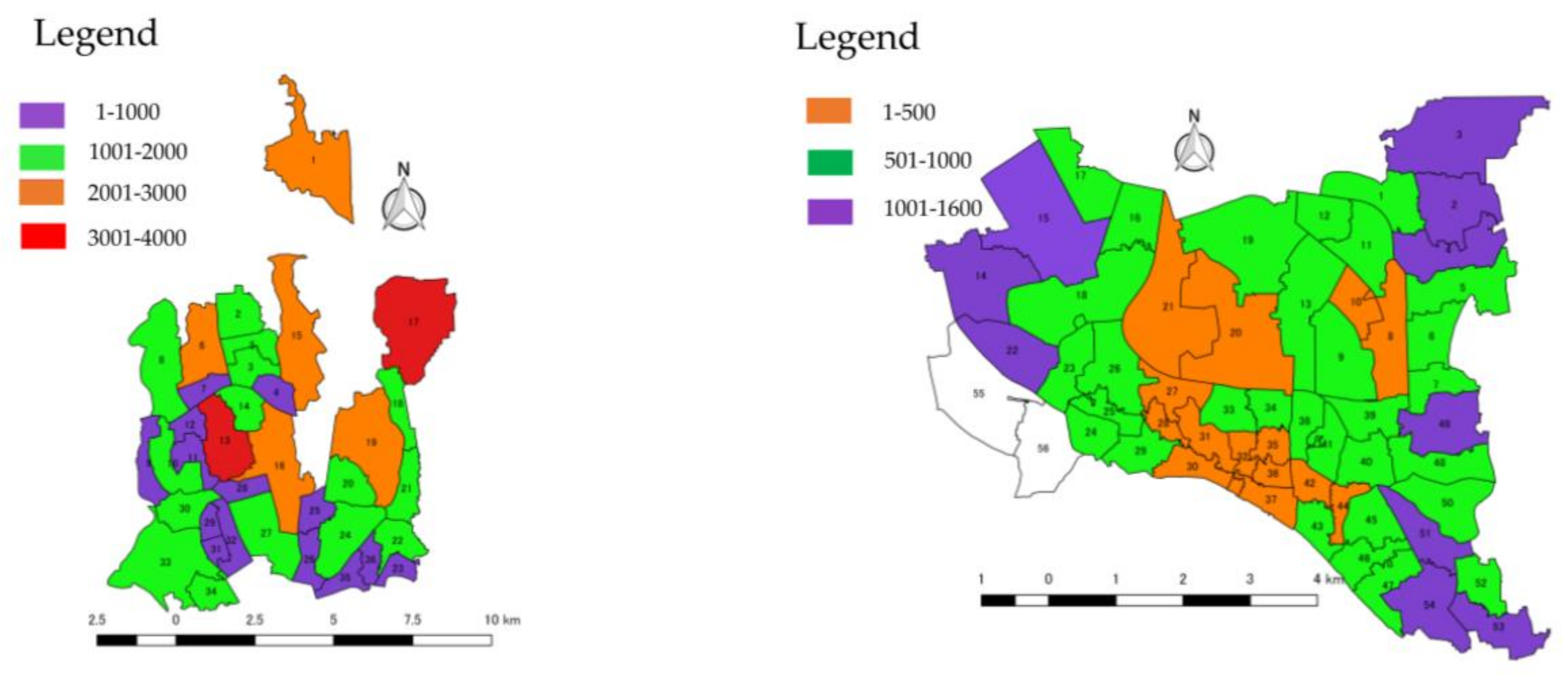
Our decision tree results (see Figure 6) for earthquake vulnerability factors indicated more soft story buildings in the DNCC than in the DSCC and, indeed, more of them are being built (see Figure 12) in the DNCC area. To lower the hazard, we highly recommend reconstructing these sorts of buildings or applying high performance fiber reinforced cementitious composite (HPFRCC) devices to their structures to mitigate earthquake damage [8].
Heavy overhanging floors in multistory buildings leads to inconsistency in stiffness and mass distribution. From the viewpoint of earthquake engineering, these irregular plan shapes are undesirable because they cause an unsuitable dynamic behavior when subjected to horizontal earthquake ground motion. For example, torsional moment in buildings increases during an earthquake because of the asymmetric distribution of mass and stiffness [12].
The pounding of adjacent buildings also causes structural damage. Proper distances should be maintained between adjacent buildings in order to reduce these catastrophic effects. In some areas where a series of buildings are constructed side by side, the outside edges of buildings on the end may be forced outward, resulting in severe damage, while inner buildings are protected from such extreme lateral deformation [47].
Topographic implications may also enhance ground motion intensity on hilltops during earthquakes. For example, most buildings located on steep slopes (greater than 30 degrees) have discontinuous foundations that can transfer the ground movement distribution evenly to the structural components above.

5. Conclusions

Rapid urbanization without proper planning and unregulated population migration have created zones in Dhaka city where the earthquake hazard is quite elevated. In a disaster like a medium-sized earthquake in or around Dhaka, the catastrophic effects would be unthinkable. This paper examines housing structures and vulnerability factors in Dhaka city in order to facilitate earthquake preparations. This study presents significant findings to help identify housing structures towards earthquake vulnerability in comparison to two main parts of Dhaka city. We believe that our study will provide valuable information about the pattern of housing structures and the results obtained have made it possible to identify the strengths and weaknesses of DNCC and DSCC. Based on our analysis, we found that the DSCC constitutes a higher hazard than the DNCC because of its outdated buildings, weak building materials, and soft-story structures. Thus, it is of utmost importance to make a significant push to construct new buildings and implement seismic retrofit policies, particularly in the DSCC area. In the DNCC area, there is a need to apply HPFRCC devices to soft-story buildings to mitigate future earthquake hazards. Future studies are required to understand the seismic retrofit imposed on housing infrastructure both in the DNCC and DSCC area during post-disaster recovery. Additionally, further studies are needed to estimate the quality of housing materials and to increase public awareness of earthquake safety.

Acknowledgments

This research is supported by the Nishimura International Scholarship Foundation (NISF).

Author Contributions

Md Sohel Ahmed and Hiroshi Morita conceived the research theme. Md Sohel Ahmed designed the statistical analysis, analyzed data, prepared to map, and wrote the paper. Hiroshi Morita contributed to writing the paper as well as evaluated the results and advised on methods.

Conflicts of Interest

The authors declare no conflict of interest.

References

  1. Rahman, M.Z.; Siddiqua, S.; Kamal, A.S.M.M. Liquefaction hazard mapping by liquefaction potential index for Dhaka City, Bangladesh. Eng. Geol. 2015, 188, 137–147. [Google Scholar] [CrossRef]
  2. Ahmed, M.Z.; Islam, K.; Roy, K.S.; Arafat, M.S.; Al-Hussaini, T.M. Seismic vulnerability assessment of RCF buildings in old town of Dhaka city. In Proceedings of the 3rd International Earthquake Symposium, Dhaka, Bangladesh, 5–6 March 2010. [Google Scholar]
  3. Roy, S.; Khan, M.S.R.; Ahmad, S.I. Comparative Cost Analysis of Possible Seismic Retrofitting Schemes for Multi-Story Unreinforced Masonry Building. Procedia Eng. 2013, 54, 584–590. [Google Scholar] [CrossRef]
  4. Zhao, B.; Fabio, T.; Tiziana, R. Field investigation on the performance of building structures during the 12 May 2008 Wenchuan earthquake in China. Eng. Struct. 2009, 31, 1707–1723. [Google Scholar] [CrossRef]
  5. Adanur, S. Performance of masonry buildings during the 20 and 27 December 2007 Bala (Ankara) earthquakes in Turkey. Nat. Hazards Earth Syst. Sci. 2010, 10, 2547. [Google Scholar] [CrossRef] [Green Version]
  6. Rahman, A.; Ueda, T. Seismic rehabilitation of masonry structure strengthening by two distinct FRPs. In Proceedings of the IABSE-JSCE Joint Conference on Advances in Bridge Engineering-III, Dhaka, Bangladesh, 21–22 August 2015. [Google Scholar]
  7. Solberg, C.; Rossetto, T.; Joffe, H. The social psychology of seismic hazard adjustment: Re-evaluating the international literature. Nat. Hazards Earth Syst. Sci. 2010, 10, 1663–1677. [Google Scholar] [CrossRef] [Green Version]
  8. Fukuyama, H. Application of high performance fiber reinforced cementitious composites for damage mitigation of building structures. J. Adv. Concr. Technol. 2006, 4, 35–44. [Google Scholar] [CrossRef]
  9. Erdik, M.; Durukal, E. Earthquake risk and its mitigation in Istanbul. Nat. Hazards 2008, 44, 181–197. [Google Scholar] [CrossRef]
  10. Sarker, P.; Begum, M.; Nasrin, S. Fiber reinforced polymers for structural retrofitting: A review. J. Civ. Eng. 2011, 39, 49–57. [Google Scholar]
  11. Housing—Banglapedia. Available online: http://en.banglapedia.org/index.php?title=Housing (accessed on 8 November 2017).
  12. Comprehensive Disaster Management Programme (CDMP). Seismic Hazard and Vulnerability Assessment of Dhaka, Chittagong and Sylhet City Corporation Areas; Final Report; Ministry of Food and Disaster Management: Dhaka, Bangladesh, 2009.
  13. Barua, U.; Akhter, M.S.; Ansary, M.A. District-wise multi-hazard zoning of Bangladesh. Nat. Hazards 2016, 82, 1895–1918. [Google Scholar] [CrossRef]
  14. Aitsi-Selmi, A.; Murray, V.; Wannous, C.; Dickinson, C.; Johnston, D.; Kawasaki, A.; Yeung, T. Reflections on a Science and Technology Agenda for 21st Century Disaster Risk Reduction: Based on the Scientific Content of the 2016 UNISDR Science and Technology Conference on the Implementation of the Sendai Framework for Disaster Risk Reduction 2015–2030. Int. J. Disaster Risk Sci. 2016, 7, 1–29. [Google Scholar] [CrossRef]
  15. Ahmed, I. Factors in building resilience in urban slums of Dhaka, Bangladesh. Procedia Econ. Financ. 2014, 18, 745–753. [Google Scholar] [CrossRef]
  16. Asian Disaster Preparedness Center (ADPC). Earthquake Contingency Plan for Dhaka City Corporation (DCC); Comprehensive Disaster Management Programme (CDMP): Dhaka, Bangladesh, 2009. [Google Scholar]
  17. Ahmed, M.S.; Morita, H. Earthquake disaster management analysis in Dhaka. In Proceedings of the Humanitarian Technology Conference (IHTC), Toronto, ON, Canada, 21–22 July 2017; pp. 46–50. [Google Scholar]
  18. Nakagawa, Y. The lived experience of preparing for earthquakes in households: A phenomenological psychological study. Nat. Hazards 2017, 88, 1825–1844. [Google Scholar] [CrossRef]
  19. Al-Hussaini, T.M.; Chowdhury, I.N.; Noman, M.N. Seismic hazard assessment for Bangladesh-old and new perspectives. In Proceedings of the First International conference on CICM, Dhaka, Bangladesh, 14–15 December 2015. [Google Scholar]
  20. DDC. Bangladesh National Building Code 1993; Development Design Consultants for Housing and Building Research Institute: Dhaka, Bangladesh, 1993.
  21. URP- phase 1. Bangladesh Urban Resilience Project, Environmental Management Framework (EMF) Draft; The World Bank: Washington, DC, USA, 2014. [Google Scholar]
  22. Khan, A.A. Geophysical characterization and earthquake hazard vulnerability of Dhaka Mega City, Bangladesh, vis-à-vis impact of scenario earthquakes. Nat. Hazards 2016, 82, 1147–1166. [Google Scholar] [CrossRef]
  23. Search Earthquake Catalog. Available online: https://earthquake.usgs.gov/earthquakes/search/ (accessed on 16 February 2018).
  24. Alam, E.; Dominey-Howes, D. An analysis of the AD1762 earthquake and tsunami in SE Bangladesh. Nat. Hazards 2014, 70, 903–933. [Google Scholar] [CrossRef]
  25. BBS Statistical Yearbook of Bangladesh; Bangladesh Bureau of Statistics (BBS), Government of Bangladesh: Dhaka, Bangladesh, 2012; ISBN 9789849005599.
  26. Rizvi, S.N.H. East Pakistan District Gazetteers: Dacca; East Pakistan Government Press: Dhaka, Bangladesh, 1969; p. 353.
  27. Rizvi, S.N.H. East Pakistan District Gazetteers: Chittagong; East Pakistan Government Press: Dhaka, Bangladesh, 1970; p. 344.
  28. Del Gobbo, G.M.; Williams, M.S.; Blakeborough, A. Seismic Performance Assessment of a Conventional Multi-storey Building. Int. J. Disaster Risk Sci. 2017, 8, 237–245. [Google Scholar] [CrossRef]
  29. Al-Hussaini, T. Critical Elements for Earthquake Disaster in Dhaka City. New Technology for Urban Safety of Mega Cities in Asia. In Proceedings of the 2nd International Symposium on New Technologies for Urban Safety of Mega Cities in Asia, Tokyo, Japan, 30–31 October 2003. [Google Scholar]
  30. Barua, U.; Ansary, M.A. Workplace safety in Bangladesh ready-made garment sector: 3 years after the Rana Plaza collapse. Int. J. Occup. Saf. Ergon. 2017, 23, 578–583. [Google Scholar] [CrossRef] [PubMed]
  31. Ansary, M.A.; Barua, U. Workplace safety compliance of RMG industry in Bangladesh: Structural assessment of RMG factory buildings. Int. J. Disaster Risk Reduct. 2015, 14, 424–437. [Google Scholar] [CrossRef]
  32. Ansary, M.A.; Rahman, M.S. Site amplification investigation in Dhaka, Bangladesh, using H/V ratio of microtremor. Environ. Earth Sci. 2013, 70, 559–574. [Google Scholar] [CrossRef]
  33. Location and Area, Dhaka North City Corporation. Available online: http://www.dncc.gov.bd/site/page/c0b6953f-16d3-405b-85e9-dece13bb98de/Location-and-Area (accessed on 4 April 2018).
  34. Uddin Ahmeda, S.; Mohuyab, F.A. Growth and Development of Dhaka North: 1971–2011. J. Asiat. Soc. Bangladesh Hum. 2013, 58, 303–334. [Google Scholar]
  35. Dhaka South City Corporation. Available online: http://www.dhakasouthcity.gov.bd/ (accessed on 4 April 2018).
  36. Ferdous, I.; Rahman, M. Citizens at risk from earthquake hazard in Dhaka city: Scaling risk factors from household to city region level. J. Geogr. Inst. Jovan Cvijic SASA 2015, 65, 91–106. [Google Scholar] [CrossRef]
  37. Jahan, I.; Ansary, M.A.; Ara, S.; Islam, I. Assessing social vulnerability to earthquake hazard in old Dhaka, Bangladesh. Asian J. Environ. Disaster Manag. 2011, 3, 285–300. [Google Scholar] [CrossRef]
  38. Zhao, Y.; Zhang, Y. Comparison of decision tree methods for finding active objects. Adv. Space Res. 1959, 41, 1955–1959. [Google Scholar] [CrossRef]
  39. Kuhn, M.; Johnson, K. Applied Predictive Modeling; Springer: Berlin, Germany, 2013; ISBN 9781461468493. [Google Scholar] [CrossRef]
  40. Atkins, J.P.; Burdon, D.; Allen, J.H. An application of contingent valuation and decision tree analysis to water quality improvements. Mar. Pollut. Bull. 2007, 55, 591–602. [Google Scholar] [CrossRef] [PubMed]
  41. Breiman, L. Random Forests; Kluwer Academic Publishers: Dordrecht, The Netherlands, 2001; Volume 45, pp. 5–32. [Google Scholar]
  42. Reinforced Concrete. Wikipedia (2018). Available online: https://en.wikipedia.org/w/index.php?title=Reinforced_concrete&oldid=830231868 (accessed on 3 April 2018).
  43. Mohuya. Climate change and city: An utopian debate or white truth. In Souvenir of the World Habitat Day 2011- Cities and Climate Change; Kalam, A.A., Nazem, N.I., Eds.; Ministry of Housing and Public Works, Government of Bangladesh and UN-HABITAT: Dhaka, Bangladesh, 2011; pp. 75–78. [Google Scholar]
  44. Doğangün, A.; Ural, A.; Livaoğlu, R. Seismic performance of masonry buildings during recent earthquakes in Turkey. In Proceedings of the 14th World Conference on Earthquake Engineering, Beijing, China, 12–17 October 2008; pp. 12–17. [Google Scholar]
  45. Passmore, A.C. Twenty Styles of Architecture. In Handbook of Technical Terms Used in Architecture and Building and Their Allied Trades and Subjects; Scott, Greenwood, and Co.: London, UK, 1904. [Google Scholar]
  46. Bruneau, M. Building damage from the Marmara, Turkey earthquake of August 17, 1999. J. Seismol. 2002, 6, 357–377. [Google Scholar] [CrossRef]
  47. Otani, S. Earthquake resistant design of reinforced concrete buildings. J. Adv. Concr. Technol. 2004, 2, 3–24. [Google Scholar] [CrossRef]
Figure 1. Seismic hazard zoning map of Bangladesh (BNBC-1993).
Sustainability 10 01106 g001
Figure 2. Earthquakes in and around Bangladesh (latitude 21.24–26.6, longitude 88.06–92.483) (Data source: USGS).
Sustainability 10 01106 g002
Figure 3. Bangladesh location map and study area.
Sustainability 10 01106 g003
Figure 4. Decision tree for housing structure type in Dhaka city.
Sustainability 10 01106 g004
Figure 5. Decision tree for building age in Dhaka city.
Sustainability 10 01106 g005
Figure 6. Decision tree for building age in Dhaka city.
Sustainability 10 01106 g006
Figure 7. Overall random forest model error rates: out-of-bag (OOB) (black line); Dhaka North City Corporation (DNCC) (red line) and Dhaka South City Corporation (DSCC) (green line).
Sustainability 10 01106 g007
Figure 8. Overall random forest model error rates: OOB (blue line); DNCC (red line) and DSCC (green line).
Sustainability 10 01106 g008
Figure 9. Overall random forest model error rates: OOB (blue line); 1, DNCC (red line) and 2 DSCC (green line).
Sustainability 10 01106 g009
Figure 10. Number of reinforced concrete buildings in the DNCC and DSCC (Data source: CDMP-2009).
Sustainability 10 01106 g010
Figure 11. Numbers of buildings 10 to 30 years old in the DNCC and DSCC (Data source: CDMP-2009).
Sustainability 10 01106 g011
Figure 12. Numbers of soft story buildings in the DNCC and DSCC (Data source: CDMP-2009).
Sustainability 10 01106 g012
Table 1. Fault Line Sources and Estimated Maximum Magnitude.
SourceEstimated Maximum Magnitude
Madhupur Fault7.5
Dauki Fault8.0
Plate Boundary Fault 18.5
Plate Boundary Fault 28.0
Plate Boundary Fault 38.3
Table 2. Variable importance of housing structure.
VariableMean Gini Decrease
Reinforced concrete building7.107414
Lightly reinforced concrete building5.385688
Brick in cement mortar with concrete floor5.945903
Brick in cement mortar with flexible roof4.944385
Tin and bamboo mixed6.594351
Table 3. Variable importance of building age.
VariableMean Gini Decrease
10 years9.965379
10–30 years10.390261
Over 30 years9.566955
Table 4. Variable Importance of earthquake vulnerability factors.
VariableMean Gin Decrease
Soft first story6.911157
Heavy overhang7.043463
Short columns7.693125
Pounding effects6.615364
Topographic effects1.714052