Responses of Urban Land Surface Temperature on Land Cover: A Comparative Study of Vienna and Madrid


 , ,
, ,
Abstract
:
1. Introduction
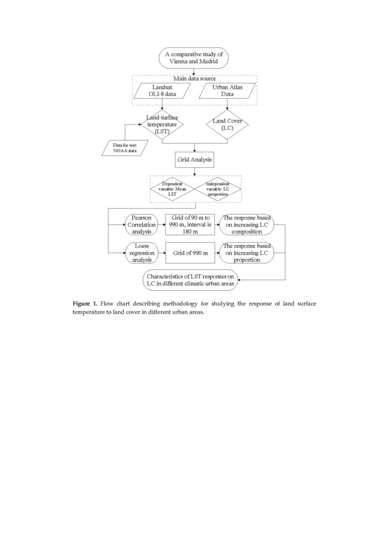
2. Materials and Methods
- Comparing two study areas with different climates, to increase the credibility and comprehensiveness of the results, and to acquire a better understanding of the relationship between LCs and LST patterns in different climatic areas.
- Using grid analysis to build quantitative relationships between LST and LC at different analytical scales, to find a suitable scale for measuring the responses, by using the differences between the simple LC patterns at fine spatial analytical scales and the multiple LC combinations under larger spatial scales.
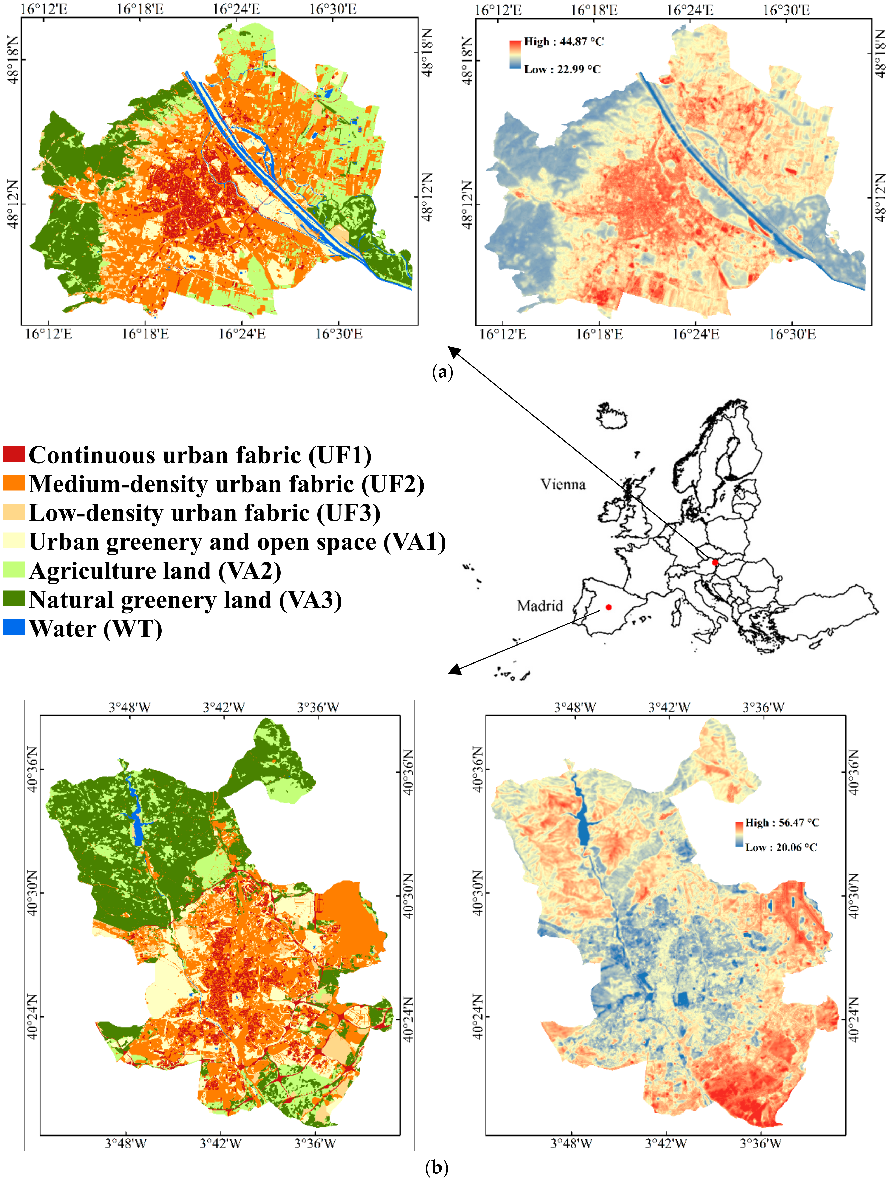
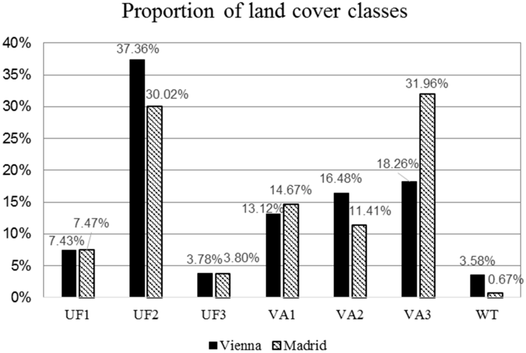
2.1. Study Area
2.2. Data Sources and Image Pre-Processing
2.2.1. Land Cover Data and Aggregation
2.2.2. Land Surface Temperature Retrieval
- Calculation of the Top of Atmospheric radiance (TOA);
- Transformation of spectral radiance to blackbody temperature ();
- Calculation of NDVI;
- Calculation of the fractional vegetation cover ()
- Calculation of LSE;
- Calculation of LST.
- = Black body Temperature;
- = Wavelength of emitted radiance;
- ρ = h × c/σ =1.438 × 10⁻² mK (σ = Boltzmann constant = 1.38 × 10⁻²³ J/K, h = Planck’s constant = 6.626 × 10⁻³⁴ Js, c = velocity of light = 2.998 × 10⁸ m/s);
- ε = Land surface emissivity (LSE)
2.3. Statistics
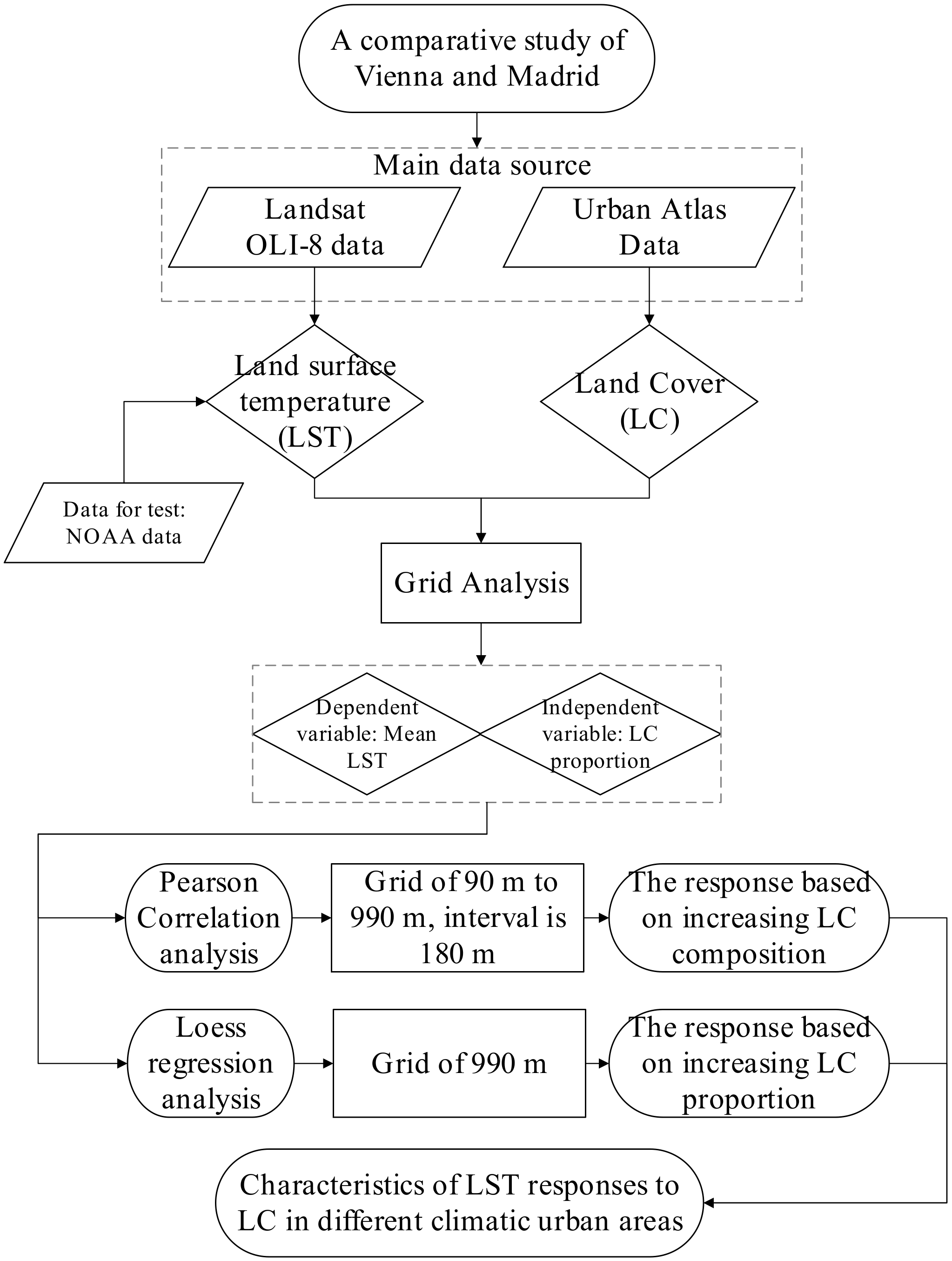
- The original LST images are resampled at six spatial scales with the following grid sizes: 1. 90 × 90 m2 (3 × 3 pixels); 2. 270 × 270 m2 (9 × 9 pixels); 3. 450 × 450 m2 (15 × 15 pixels); 4. 630 × 630 m2 (21 × 21 pixels); 5. 810 × 810 m2 (27 × 27 pixels); 6. 990 × 990 m2 (33 × 33 pixels). We build the grids with six different sizes based on the template extent of the study area with the origin coordinate. Then, the mean LST of each grid at the six scales is extracted with the spatial statistics tool (zonal statistics) of ArcGIS 10.2, and the resulting images are shown in Figure 2.
- We acquire the mean LST of each grid as the dependent variable, and the proportion of each LC type on the corresponding grid as the independent variable. A Pearson correlation analysis is firstly conducted at each of the analytical scales to identify the correlation coefficient between the LST and the proportion of each LC. With the increase of the spatial scale, the resulting analysis allowed for the determination of the change of the LST-LC correlation coefficient based on variable LC combinations, which provides an interpretation of the suitable scale for analyzing the LC–LST relationship.
- A Loess regression analysis is next applied to reveal the characteristics of LST responses based on a changing LC proportion, with attention paid to the LC compositions that display negative or positive effects on LST. We select the spatial analytical scale of 990 × 990 m2 due to its advantage of combination expression to analyze the combined effects.
3. Results
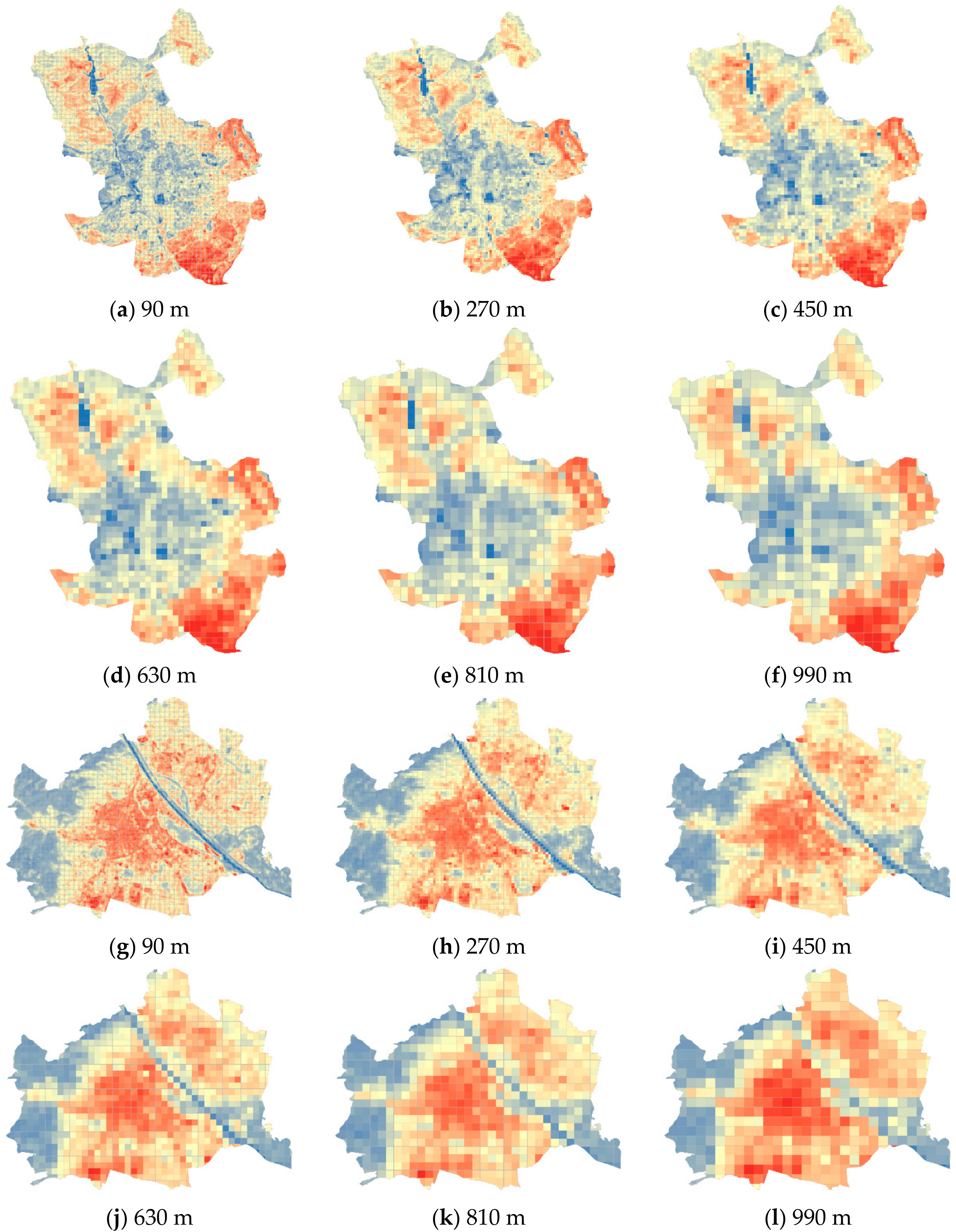
3.1. The Distribution and Characteristics of LC and LST in the Two Study Areas
3.2. The Relationship of LC to LST in Different Spatial Analysis Scales
- (1)
- Urban fabric area (UF1/UF2/UF3) contrast: For Vienna, the correlation coefficient between LST and LC is highest in continuous urban fabric (UF1), at all analytical scales. The positive correlation coefficients of UF1 and medium-density urban fabric (UF2) increase as the spatial scale increases in size. The low-density urban fabric (UF3) in Vienna does not clearly correlate with LST, and it shows a negative correlation coefficient when the scale of analysis is over 270 m. In Madrid, there is no significant correlation for any of the three kinds of urban fabric, including UF1 and UF2, in contrast to Vienna. Moreover, the correlation coefficients do not differ significantly as the scale of analysis increases.
- (2)
- Vegetation area (VA1/VA2/VA3) contrast: Urban greenery and open space (VA1) and natural greenery land (VA3) show negative correlations, and agricultural land (VA2) shows a positive correlation with LST, under all analytical scales in the two study areas. For Vienna, the correlations between LST and VA3 are stronger than VA1 and VA2 across all the analytical scales. In addition, the correlation coefficients of VA1 and VA3 are very similar at the 90 m scale of analysis, in which the interior LC type is relatively simple. As the analytical scale increases, the correlation coefficients of VA1 and LST decline, while the correlation coefficients of VA3 increase. For Madrid, the correlation coefficients of the three kinds of vegetation area are all relatively low. It can’t be ignored that VA1 has the second most negative correlation coefficient (lower than water). With the increase of the scale, the negative correlation coefficients of VA1 to LST increase, in diametric opposition to Vienna.
- (3)
- Water (WT) contrast: The correlation coefficients of WT are notable in the two cities at all analytical scales, which indicates significant cooling effects. In Madrid, the correlation coefficients between LC and LST are all below 0.3, except for WT, for which the correlation coefficient is significantly different. The correlation coefficient is highest at the analytical scale of 270 m. The correlation coefficient of WT is lowest at the analysis scale of 990 m.
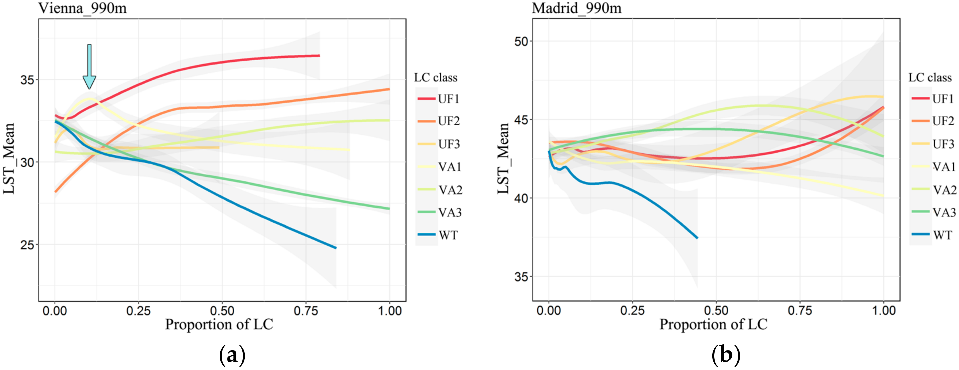
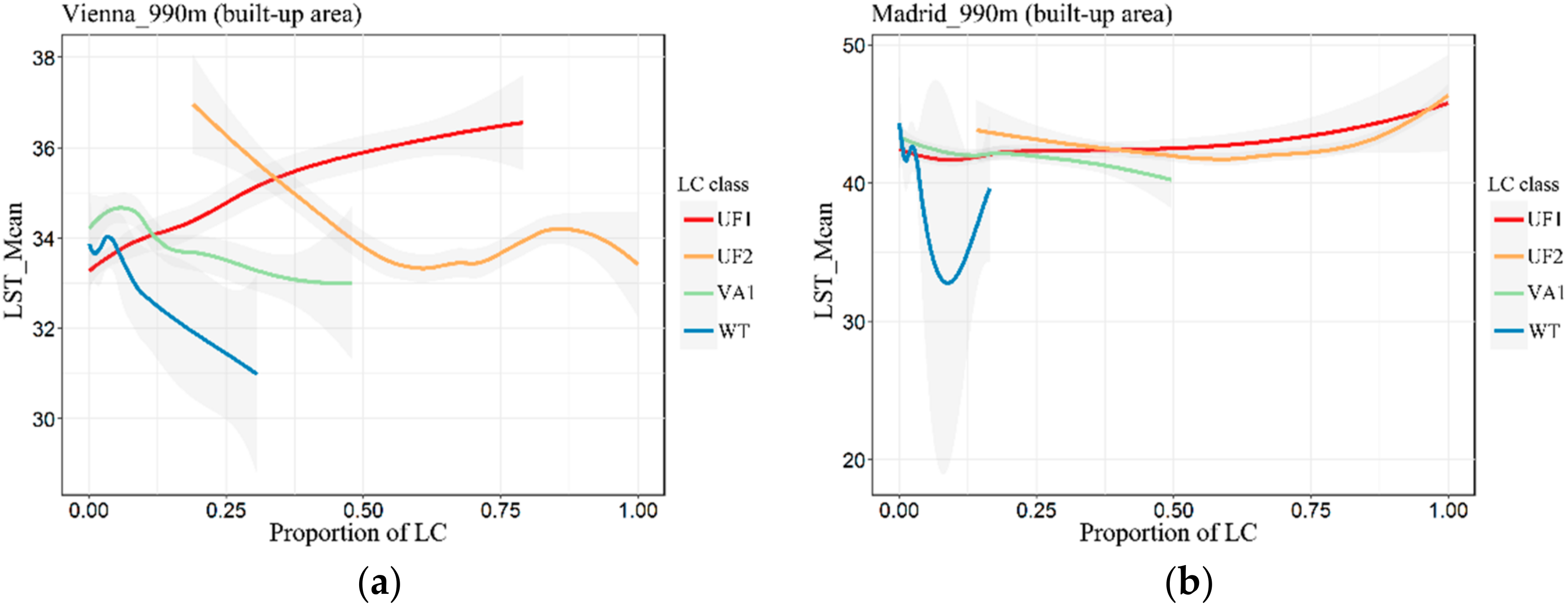
3.3. The Effects of LC in Specific Urban Combinations
4. Discussion
4.1. Characteristics of LST Patterns and the Factors Affecting LST in Different Climatic Areas
4.2. Characteristics of LST Responses to Land Cover: Difference between Cities and Various Analytical Scales
4.3. The Effects of Land Cover Composition on LST in Two Urban Areas and Further Suggestion for Urban Planning
5. Conclusions
- (1)
- In summer, Vienna presents high temperatures in the urban areas and low temperatures in the surrounding rural areas. The continuous urban fabric area (VA1) shows the strongest positive correlations with LST. Madrid displays relatively cooler in urban areas compared to rural areas. Water (WT) is the most negative factor affecting LST. None of the correlation coefficients between other LC classes and LST is above 0.3 in Madrid.
- (2)
- Suitable analytical scales are suggested for studying the LC–LST relationship between different LCs and different study areas. In Vienna, to analyze the urban fabric areas (UF1 and UF2) and natural greenery land (VA3) a large scale is appropriate, but a fine scale should be used for urban greenery and open space (VA1). In Madrid, we suggest using a relatively fine analytical scale to study the effects of water (WT), since the correlation coefficients of water (WT) decreased when the analysis scale exceeded 270 m. Considering the main factors affecting LST in the two study areas, for Vienna, the analytical scale between 810 m and 990 m is suggested to quantify the relationship of LC and LST, while for Madrid, an analytical scale between 270 m and 450 m is suggested.
- (3)
- The negative effects of LC on LST appear when the area of the cooling sources, such as water (WT) or urban greenery and open space (VA1), reaches 10% at the 990 m scale in Vienna. Built-up areas become the main factor of affecting elevated LST when they cover the majority at the 990 m scale in Madrid.
Acknowledgments
Author Contributions
Conflicts of Interest
References
- Oke, T.R. Boundary Layer Climates, 2nd ed.; Routledge: London, UK, 1988. [Google Scholar]
- Gabriel, K.M.A.; Endlicher, W.R. Urban and rural mortality rates during heat waves in Berlin and Brandenburg, Germany. Environ. Pollut. 2011, 159, 2044–2050. [Google Scholar] [CrossRef] [PubMed]
- Chandler, T.J. The Climates of London; Hutchinson: London, UK, 1965. [Google Scholar]
- Pal, S.; Xueref-Remy, I.; Ammoura, L.; Chazette, P.; Gibert, F.; Royer, P.; Dieudonné, E.; Dupont, J.C.; Haeffelin, M.; Lac, C.; et al. Spatio-temporal variability of the atmospheric boundary layer depth over the Paris agglomeration: An assessment of the impact of the urban heat island intensity. Atmos. Environ. 2012, 63, 261–275. [Google Scholar] [CrossRef]
- Lac, C.; Donnelly, R.P.; Masson, V.; Pal, S.; Riette, S.; Donier, S.; Queguiner, S.; Tanguy, G.; Ammoura, L.; Xueref-Remy, I. CO2 dispersion modelling over Paris region within the CO2-MEGAPARIS project. Atmos. Chem. Phys. 2013, 13, 4941–4961. [Google Scholar] [CrossRef]
- Rosenfeld, A.H.; Akbari, H.; Bretz, S.; Fishman, B.L.; Kurn, D.M.; Sailor, D.; Taha, H. Mitigation of urban heat islands: Materials, utility programs, updates. Energy Build. 1995, 22, 255–265. [Google Scholar] [CrossRef]
- Vuckovic, M.; Kiesel, K.; Mahdavi, A. The Extent and Implications of the Microclimatic Conditions in the Urban Environment: A Vienna Case Study. Sustainability 2017, 9, 177. [Google Scholar] [CrossRef]
- Norton, B.A.; Coutts, A.M.; Livesley, S.J.; Harris, R.J.; Hunter, A.M.; Williams, N.S.G. Planning for cooler cities: A framework to prioritise green infrastructure to mitigate high temperatures in urban landscapes. Landsc. Urban Plan. 2015, 134, 127–138. [Google Scholar] [CrossRef]
- Revell, G.; Anda, M. Sustainable Urban Biophilia: The Case of Greenskins for Urban Density. Sustainability 2014, 6, 5423–5438. [Google Scholar] [CrossRef]
- Rajeshwari, A.; Mani, N. Estimation of land surface temperature of Dindigul district using Landsat 8 data. Int. J. Res. Eng. Technol. 2014, 3, 122–126. [Google Scholar]
- Alipour, T.; Sarajian, M.; Esmaeily, A. Land surface temperature estimation from thermal band of landsat sensor, case study: Alashtar City. Int. Arch. Photogramm. Remote Sens. Spat. Inf. Sci. 2003, 36, 1020–1044. [Google Scholar]
- Voogt, J.A.; Oke, T.R. Thermal remote sensing of urban climates. Remote Sens. Environ. 2003, 86, 370–384. [Google Scholar] [CrossRef]
- Alavipanah, S.; Wegmann, M.; Qureshi, S.; Weng, Q.; Koellner, T. The Role of Vegetation in Mitigating Urban Land Surface Temperatures: A Case Study of Munich, Germany during the Warm Season. Sustainability 2015, 7, 4689–4706. [Google Scholar] [CrossRef]
- Guan, Y.; Qian, D.; Zhang, C.; Cai, D.; Liu, X.; Guo, S. Urban Surface Energy Distribution and Related Characteristics: An Remote Sensing Based Research Applied to the International Livable Cities. J. Geo-Inf. Sci. 2014, 16, 806–814. [Google Scholar]
- Zhou, W.; Qian, Y.; Li, X.; Li, W.; Han, L. Relationships between land cover and the surface urban heat island: Seasonal variability and effects of spatial and thematic resolution of land cover data on predicting land surface temperatures. Landsc. Ecol. 2013, 29, 153–167. [Google Scholar] [CrossRef]
- Sobrino, J.A.; Oltra-Carrió, R.; Sòria, G.; Jiménez-Muñoz, J.C.; Franch, B.; Hidalgo, V.; Mattar, C.; Julien, Y.; Cuenca, J.; Romaguera, M.; et al. Evaluation of the surface urban heat island effect in the city of Madrid by thermal remote sensing. Int. J. Remote Sens. 2013, 34, 3177–3192. [Google Scholar] [CrossRef]
- Zhou, W.; Huang, G.; Cadenasso, M.L. Does spatial configuration matter? Understanding the effects of land cover pattern on land surface temperature in urban landscapes. Landsc. Urban Plan. 2011, 102, 54–63. [Google Scholar] [CrossRef]
- Zhou, W.; Wang, J.; Cadenasso, M.L. Effects of the spatial configuration of trees on urban heat mitigation: A comparative study. Remote Sens. Environ. 2017, 195, 1–12. [Google Scholar] [CrossRef]
- Vasishth, A. Ecologizing Our Cities: A Particular, Process-Function View of Southern California, from within Complexity. Sustainability 2015, 7, 11756–11776. [Google Scholar] [CrossRef]
- Grimm, N.B.; Faeth, S.H.; Golubiewski, N.E.; Redman, C.L.; Wu, J.; Bai, X.; Briggs, J.M. Global change and the ecology of cities. Science 2008, 319, 756–760. [Google Scholar] [CrossRef] [PubMed]
- Zhou, B.; Rybski, D.; Kropp, J.P. The role of city size and urban form in the surface urban heat island. Sci. Rep. 2017, 7, 4791. [Google Scholar] [CrossRef] [PubMed]
- Cai, D.; Fraedrich, K.; Guan, Y.; Guo, S.; Zhang, C. Urbanization and the thermal environment of Chinese and US-American cities. Sci. Total Environ. 2017, 589, 200–211. [Google Scholar] [CrossRef] [PubMed]
- Yang, J.C.; Wang, Z.H.; Kaloush, K.E.; Dylla, H. Effect of pavement thermal properties on mitigating urban heat islands: A multi-scale modeling case study in Phoenix. Build. Environ. 2016, 108, 110–121. [Google Scholar] [CrossRef]
- Zhou, J.; Liu, S.; Li, M.; Zhan, W.; Xu, Z.; Xu, T. Quantification of the Scale Effect in Downscaling Remotely Sensed Land Surface Temperature. Remote Sens. 2016, 8, 975. [Google Scholar] [CrossRef]
- Liu, H.; Weng, Q. Scaling effect on the relationship between landscape pattern and land surface temperature. Photogramm. Eng. Remote Sens. 2009, 75, 291–304. [Google Scholar] [CrossRef]
- Schwarz, N.; Lautenbach, S.; Seppelt, R. Exploring indicators for quantifying surface urban heat islands of European cities with MODIS land surface temperatures. Remote Sens. Environ. 2011, 115, 3175–3186. [Google Scholar] [CrossRef]
- Pauleit, S.; Ennos, R.; Golding, Y. Modeling the environmental impacts of urban land use and land cover change—A study in Merseyside, UK. Landsc. Urban Plan. 2005, 71, 295–310. [Google Scholar] [CrossRef]
- Liao, F.-C.; Cheng, M.-J.; Hwang, R.-L.; Yang, W.-S. The effect of land cover and land use on urban heat island in Taiwan. In Proceedings of the World SB14, Barcelona, Spain, 28–30 October 2014; pp. 1–8. [Google Scholar]
- Murphy, D.J.; Hall, M.H.; Hall, C.A.; Heisler, G.M.; Stehman, S.V.; Anselmi-Molina, C. The relationship between land cover and the urban heat island in northeastern Puerto Rico. Int. J. Climatol. 2011, 31, 1222–1239. [Google Scholar] [CrossRef]
- Weng, Q.; Lu, D.; Schubring, J. Estimation of land surface temperature-vegetation abundance relationship for urban heat island studies. Remote Sens. Environ. 2004, 89, 467–483. [Google Scholar] [CrossRef]
- Stewart, I.D.; Oke, T.R. Local Climate Zones for Urban Temperature Studies. Bull. Am. Meteorol. Soc. 2012, 93, 1879–1900. [Google Scholar] [CrossRef]
- Yang, Q.; Huang, X.; Li, J. Assessing the relationship between surface urban heat islands and landscape patterns across climatic zones in China. Sci. Rep. 2017, 7, 9337. [Google Scholar] [CrossRef] [PubMed]
- Zhou, D.; Zhao, S.; Liu, S.; Zhang, L.; Zhu, C. Surface urban heat island in China’s 32 major cities: Spatial patterns and drivers. Remote Sens. Environ. 2014, 152, 51–61. [Google Scholar] [CrossRef]
- Sun, R.; Chen, L. Effects of green space dynamics on urban heat islands: Mitigation and diversification. Ecosyst. Serv. 2017, 23, 38–46. [Google Scholar] [CrossRef]
- Brunori, E.; Salvati, L.; Mancinelli, R.; Smiraglia, D.; Biasi, R. Multi-temporal land use and cover changing analysis: The environmental impact in Mediterranean area. Int. J. Sustain. Dev. World Ecol. 2017, 24, 276–288. [Google Scholar] [CrossRef]
- Azevedo, J.; Chapman, L.; Muller, C. Quantifying the Daytime and Night-Time Urban Heat Island in Birmingham, UK: A Comparison of Satellite Derived Land Surface Temperature and High Resolution Air Temperature Observations. Remote Sens. 2016, 8, 153. [Google Scholar] [CrossRef]
- Akbari, H.; Pomerantz, M.; Taha, H. Cool surfaces and shade trees to reduce energy use and improve air quality in urban areas. Sol. Energy 2001, 70, 295–310. [Google Scholar] [CrossRef]
- Zipper, S.C.; Schatz, J.; Singh, A.; Kucharik, C.J.; Townsend, P.A.; Loheide, S.P. Urban heat island impacts on plant phenology: Intra-urban variability and response to land cover. Environ. Res. Lett. 2016, 11, 054023. [Google Scholar] [CrossRef]
- Zhang, X.X.; Wu, P.F.; Chen, B. Relationship between vegetation greenness and urban heat island effect in Beijing City of China. Procedia Environ. Sci. 2010, 2, 1438–1450. [Google Scholar] [CrossRef]
- Chen, L.; Yu, B.L.; Yang, F.; Mayer, H. Intra-urban differences of mean radiant temperature in different urban settings in Shanghai and implications for heat stress under heat waves: A GIS-based approach. Energy Build. 2016, 130, 829–842. [Google Scholar] [CrossRef]
- Oke, T.R. The Heat Island of the Urban Boundary Layer: Characteristics, Causes and Effects. In Wind Climate in Cities; Cermak, J.E., Davenport, A.G., Plate, E.J., Viegas, D.X., Eds.; Springer: Dordrecht, The Netherlands, 1995. [Google Scholar]
- Park, J.; Kim, J.-H.; Lee, D.K.; Park, C.Y.; Jeong, S.G. The influence of small green space type and structure at the street level on urban heat island mitigation. Urban For. Urban Green. 2017, 21, 203–212. [Google Scholar] [CrossRef]
- Yu, X.; Guo, X.; Wu, Z. Land Surface Temperature Retrieval from Landsat 8 TIRS—Comparison between Radiative Transfer Equation-Based Method, Split Window Algorithm and Single Channel Method. Remote Sens. 2014, 6, 9829–9852. [Google Scholar] [CrossRef]
- Yuan, F.; Bauer, M.E. Comparison of impervious surface area and normalized difference vegetation index as indicators of surface urban heat island effects in Landsat imagery. Remote Sens. Environ. 2007, 106, 375–386. [Google Scholar] [CrossRef]
- Kottek, M.; Grieser, J.; Beck, C.; Rudolf, B.; Rubel, F. World Map of the Köppen-Geiger climate classification updated. Meteorol. Z. 2006, 15, 259–263. [Google Scholar] [CrossRef]
- Relative Humidity Database. Humidity Data Is Obtained from World Meteorological Organization. Available online: http://worldweather.wmo.int/en/home.html (accessed on 15 June 2017).
- Thompson, B.; Rotenberg, R. Landscape and Power in Vienna. Environ. Hist. 1997, 2, 113. [Google Scholar] [CrossRef]
- The Economist Intelligence Unit’s Livability Survey. The Economist, 2016. Available online: https://www.economist.com/blogs/graphicdetail/2016/08/daily-chart-14 (accessed on 17 June 2017).
- Street Tree Layer (STL). European Environment Agency. The Urban Atlas. 2012. Available online: http://land.copernicus.eu/local/urban-atlas/street-tree-layer-stl/view (accessed on 20 May 2017).
- Population Data. Eurostat, 2016. Available online: http://ec.europa.eu/eurostat (accessed on 17 June 2017).
- European Environment Agency (EEA). Urban Atlas Data. Programme. 2012. Available online: http://land.copernicus.eu/local/urban-atlas/ (accessed on 20 May 2017).
- Pazúr, R.; Feranec, J.; Štych, P.; Kopecká, M.; Holman, L. Changes of urbanised landscape identified and assessed by the Urban Atlas data: Case study of Prague and Bratislava. Land Use Policy 2017, 61, 135–146. [Google Scholar] [CrossRef]
- USGS. Landsat 8 Data. 2013–2018. Available online: https://glovis.usgs.gov/ (accessed on 17 May 2017).
- Oke, T.R. The energetic basis of the urban heat island. Q. J. R. Meteorol. Soc. 1982, 108, 1–24. [Google Scholar] [CrossRef]
- Spronken-Smith, R.; Oke, T. The thermal regime of urban parks in two cities with different summer climates. Int. J. Remote Sens. 1998, 19, 2085–2104. [Google Scholar] [CrossRef]
- Sobrino, J.A.; Jiménez-Muñoz, J.C.; Sòria, G.; Romaguera, M.; Guanter, L.; Moreno, J.; Plaza, A.; Martínez, P. Land surface emissivity retrieval from different VNIR and TIR sensors. IEEE Trans. Geosci. Remote Sens. 2008, 46, 316–327. [Google Scholar] [CrossRef]
- Njoku, E.G. Land Surface Emissivity Introduction; Springer: Berlin, Germany, 2014. [Google Scholar]
- Amiri, R.; Weng, Q.; Alimohammadi, A.; Alavipanah, S.K. Spatial-temporal dynamics of land surface temperature in relation to fractional vegetation cover and land use/cover in the Tabriz urban area, Iran. Remote Sens. Environ. 2009, 113, 2606–2617. [Google Scholar] [CrossRef]
- Singh, S.K.; Nishith Dharaiya, S.D. Estimation of Land Surface Temperature-Vegetation Aboundance Relationship Using LANDSAT TM 5 Data. Int. J. Eng. Sci. Res. Technol. 2015, 270–275. [Google Scholar]
- Valor, E.; Caselles, V. Mapping land surface emissivity from NDVI: Application to European, African, and South American areas. Remote Sens. Environ. 1996, 57, 167–184. [Google Scholar] [CrossRef]
- Majkowska, A.; Kolendowicz, L.; Półrolniczak, M.; Hauke, J.; Czernecki, B. The urban heat island in the city of Poznań as derived from Landsat 5 TM. Theor. Appl. Climatol. 2016, 128, 769–783. [Google Scholar] [CrossRef]
- Sobrino, J.A.; Jiménez-Muñoz, J.C.; Paolini, L. Land surface temperature retrieval from LANDSAT TM 5. Remote Sens. Environ. 2004, 90, 434–440. [Google Scholar] [CrossRef]
- Artis, D.A.; Carnahan, W.H. Survey of emissivity variability in thermography of urban areas. Remote Sens. Environ. 1982, 12, 313–329. [Google Scholar] [CrossRef]
- National Oceanic and Atmospheric Administration. Surface Hourly Abbreviated Format. Available online: https://gis.ncdc.noaa.gov/maps/ncei/cdo/hourly/ (accessed on 22 June 2017).
- Hewitt, R.; Escobar, F. The territorial dynamics of fast-growing regions: Unsustainable land use change and future policy challenges in Madrid, Spain. Appl. Geogr. 2011, 31, 650–667. [Google Scholar] [CrossRef]
- Hauleitner, F.; Hauleitner, R. Wiener Hausberge: 52 Ausgewählte Wanderungen und Spaziergänge im Schneeberg-, Rax-, Semmering-und Wechselgebiet mit Gutensteiner Alpen, Hoher Wand, Rosaliengebirge und Buckliger Welt; Bergverlag Rother GmbH: Oberhaching, Germany, 2001. [Google Scholar]
- Rasul, A.; Balzter, H.; Smith, C.; Remedios, J.; Adamu, B.; Sobrino, J.; Srivanit, M.; Weng, Q. A Review on Remote Sensing of Urban Heat and Cool Islands. Land 2017, 6, 38. [Google Scholar] [CrossRef]
- Rodríguez-Álvarez, J. Surface urban heat island and buildings energy: Visualization of urban climatic flows. Pós. Revista do Programa de Pós-Graduação em Arquitetura e Urbanismo da FAUUSP 2016, 23, 122. [Google Scholar] [CrossRef]
- Li, X.; Zhou, W.; Ouyang, Z.; Xu, W.; Zheng, H. Spatial pattern of greenspace affects land surface temperature: Evidence from the heavily urbanized Beijing metropolitan area, China. Landsc. Ecol. 2012, 27, 887–898. [Google Scholar] [CrossRef]
- Drezner, T.D.; Shaker, R.R. A new technique for predicting the sky-view factor for urban heat island assessment. Geogr. Bull. 2010, 51, 85. [Google Scholar]
- Krehbiel, C.; Zhang, X.; Henebry, G. Impacts of Thermal Time on Land Surface Phenology in Urban Areas. Remote Sens. 2017, 9, 499. [Google Scholar] [CrossRef]
- Wang, Y.; Zhan, Q.; Ouyang, W. Impact of Urban Climate Landscape Patterns on Land Surface Temperature in Wuhan, China. Sustainability 2017, 9, 1700. [Google Scholar] [CrossRef]
- Skoulika, F.; Santamouris, M.; Kolokotsa, D.; Boemi, N. On the thermal characteristics and the mitigation potential of a medium size urban park in Athens, Greece. Landsc. Urban Plan. 2014, 123, 73–86. [Google Scholar] [CrossRef]
- Bowler, D.E.; Buyung-Ali, L.; Knight, T.M.; Pullin, A.S. Urban greening to cool towns and cities: A systematic review of the empirical evidence. Landsc. Urban Plan. 2010, 97, 147–155. [Google Scholar] [CrossRef]


| City | Location | Climate | Altitude | Area | Population Density |
|---|---|---|---|---|---|
| Vienna | 48°12′N, 16°22′ E | Humid continental climate | 193 m | 414.65 km2 | 4326/km2 |
| Madrid | 40°23′ N, 3°43′ W | Inland Mediterranean climate | 646 m | 604.3 km2 | 5390/km2 |
| ID | Simplified Class Name | Class Code/Original Urban Atlas Data Class 1 |
|---|---|---|
| UF1 | Continuous urban fabric | 11100 Continuous urban fabric (S.L.: >80%); 12210 Fast transit roads and associated land |
| UF2 | Medium-density urban fabric | 11210 Discontinuous dense urban fabric (S.L.: 50–80%); 11220 Discontinuous medium density urban fabric (S.L.: 30–50%); 12100 Industrial, commercial, public, military and private units; 12220 Other roads and associated land; 12230 Railways and associated land; 12400 Airports; 13300 Construction sites |
| UF3 | Low-density urban fabric | 11230 Discontinuous low density urban fabric (S.L.: 10–30%); 11240 Discontinuous very low density urban fabric (S.L.: <10%); 11300 Isolated structures; 12300 Port areas; 13100 Mineral extraction and dump sites; 33000 Open spaces with no or little vegetation |
| VA1 | Urban greenery and open space | 13400 Land without current use; 14100 Green urban areas; 14200 Sports and leisure facilities |
| VA2 | Agricultural land | 21000 Arable land (annual crops); 22000 Permanent crops (vineyards, fruit trees, olive groves); 23000 Pastures |
| VA3 | Natural greenery land | 31000 Forests; 32000 Herbaceous vegetation associations (natural grassland, moors) |
| WT | Water | 50000 Water |
| City/Path and Row | Acquisition Date | Cloud Cover Land (%) |
|---|---|---|
| Vienna/190026 | 18/06/2013 | 0.25 |
| 05/08/2013 | 0.66 | |
| 06/09/2013 | 0.90 | |
| Madrid/201032 | 15/06/2013 | 0.08 |
| 17/07/2013 | 4.88 1 | |
| 02/08/2013 | 0.22 | |
| 18/08/2013 | 0.10 | |
| 03/09/2013 | 0.00 |
| Vienna | 90 m | 270 m | 450 m | 630 m | 810 m | 990 m |
|---|---|---|---|---|---|---|
| Continuous urban fabric (UF1) | 0.39 *** | 0.49 *** | 0.49 *** | 0.48 *** | 0.62 *** | 0.63 *** |
| Medium-density urban fabric (UF2) | 0.21 *** | 0.35 *** | 0.39 *** | 0.49 *** | 0.51 *** | 0.45 *** |
| Low-density urban fabric (UF3) | 0.07 *** | −0.01 | −0.08 * | −0.03 | −0.12 * | −0.10 |
| Urban greenery and open space (VA1) | −0.24 *** | −0.31 *** | −0.29 *** | −0.29 *** | −0.25 *** | −0.18 *** |
| Agricultural land (VA2) | 0.10 *** | 0.16 *** | 0.24 *** | 0.15 *** | 0.19 *** | 0.14 * |
| Natural greenery land (VA3) | −0.28 *** | −0.45 *** | −0.56 *** | −0.53 *** | −0.51 *** | −0.85 *** |
| Water (WT) | −0.49 *** | −0.71 *** | −0.67 *** | −0.64 *** | −0.69 *** | −0.63 *** |
| Madrid | 90 m | 270 m | 450 m | 630 m | 810 m | 990 m |
|---|---|---|---|---|---|---|
| Continuous urban fabric (UF1) | 0.09 *** | 0.03 | −0.01 | −0.03 | −0.02 | −0.04 |
| Medium-density urban fabric (UF2) | 0.01 * | −0.04 *** | −0.06 ** | −0.06 * | −0.07 * | −0.13 ** |
| Low-density urban fabric (UF3) | 0.20 *** | 0.19 *** | 0.17 *** | 0.11 * | 0.19 *** | 0.22 *** |
| Urban greenery and open space (VA1) | −0.10 *** | −0.13 *** | −0.17 *** | −0.22 *** | −0.25 *** | −0.26 *** |
| Agricultural land (VA2) | 0.09 *** | 0.12 *** | 0.17 *** | 0.29 *** | 0.16 *** | 0.12 ** |
| Natural greenery land (VA3) | −0.09 *** | −0.12 *** | −0.13 *** | −0.13 *** | −0.10 ** | −0.08 |
| Water (WT) | −0.55 *** | −0.72 *** | −0.70 *** | −0.60 *** | −0.63 *** | −0.41 *** |
© 2018 by the authors. Licensee MDPI, Basel, Switzerland. This article is an open access article distributed under the terms and conditions of the Creative Commons Attribution (CC BY) license (http://creativecommons.org/licenses/by/4.0/).
Share and Cite
Xiao, H.; Kopecká, M.; Guo, S.; Guan, Y.; Cai, D.; Zhang, C.; Zhang, X.; Yao, W. Responses of Urban Land Surface Temperature on Land Cover: A Comparative Study of Vienna and Madrid. Sustainability 2018, 10, 260. https://doi.org/10.3390/su10020260
Xiao H, Kopecká M, Guo S, Guan Y, Cai D, Zhang C, Zhang X, Yao W. Responses of Urban Land Surface Temperature on Land Cover: A Comparative Study of Vienna and Madrid. Sustainability. 2018; 10(2):260. https://doi.org/10.3390/su10020260
Chicago/Turabian StyleXiao, Han, Monika Kopecká, Shan Guo, Yanning Guan, Danlu Cai, Chunyan Zhang, Xiaoxin Zhang, and Wutao Yao. 2018. "Responses of Urban Land Surface Temperature on Land Cover: A Comparative Study of Vienna and Madrid" Sustainability 10, no. 2: 260. https://doi.org/10.3390/su10020260
APA StyleXiao, H., Kopecká, M., Guo, S., Guan, Y., Cai, D., Zhang, C., Zhang, X., & Yao, W. (2018). Responses of Urban Land Surface Temperature on Land Cover: A Comparative Study of Vienna and Madrid. Sustainability, 10(2), 260. https://doi.org/10.3390/su10020260