Article

Do Administrative Incentives for the Containment of Cities Work? An Analysis of the Accelerated Procedure for Binding Land-Use Plans for Inner Urban Development in Germany

by
Oliver Dillmann
1,2 and
Volker Beckmann
1,*
1
Faculty of Law and Economics & Institute of Botany and Landscape Ecology, University of Greifswald, 17489 Greifswald, Germany
2
Department of Building and Planning Inspection, Hanseatic City of Stralsund, 18408 Stralsund, Germany
*
Author to whom correspondence should be addressed.
Sustainability 2018, 10(12), 4745; https://doi.org/10.3390/su10124745
Submission received: 30 September 2018 / Revised: 30 November 2018 / Accepted: 5 December 2018 / Published: 12 December 2018

Abstract

:
In order to reduce land conversion for settlement and traffic purposes, the German government introduced in 2002 the 30 ha per day objective and since then established a number of policies and projects in order to achieve this goal in 2030. On 1 January 2007, an amendment of the Federal Building Code came into force, which introduced an accelerated procedure for binding land-use plans for inner urban development (section 13a). The aim of this amendment was to simplify and accelerate the planning law for projects to support inner urban development. This paper seeks to answer the question of whether or not the accelerated procedure contributes to increased inner urban development by providing incentives for the reuse of vacant developed land, which are often contaminated sites. Based on the example of the city of Stralsund in the rural region of Mecklenburg-Western Pomerania, we explore the quantitative land development in the inner and outer area from 1990 to 2018 and calculate costs savings for developers and public authorities. The results reveal that, although the accelerated procedure has been widely applied in the city of Stralsund since 2007, its effect on increased inner urban development has been very limited. The magnitude of the cost advantage is rather small, so that the accelerated procedure is often not regarded as decisive for the decision of inner versus outer development. The accelerated procedure has reduced the administrative burden for developers and public administration; however, in order to reach the 30 ha per day objective, more tailored policy instruments are needed.

1. Introduction

The continuing conversion of open space into settlements and transportation infrastructure is an international issue affecting many developing and developed countries, Germany being no exception [1,2]. In recent decades, Germany has witnessed a first increasing and then slightly decreasing rate of land conversion. It increased from about 18 ha per day at the beginning of the 1950s to 167 ha per day at the end of the 1970s [3]. Between 1997 and the year 2000, the daily conversion was fairly stable at about 129 ha, and, after fluctuations between 2000 and 2005, land conversion steadily decreased to 65 ha per day in 2015 [4] As a consequence, in the last 60 years, the amount of area that is used for settlement and transport purposes has almost doubled. The increase is essentially at the expense of agricultural land [5]. Nowadays, about 14.2 percent of total land coverage in Germany is used for settlement and transport purposes [4]. In rural and suburban regions, the land conversion rates for settlement and traffic are above the national average [6].
There are multiple reasons for these developments, which can be divided into economic, demographical, social, political, and administrative reasons or drivers. Some argue that land conversion for settlement and traffic also follows the shape of an environmental Kuznets curve, where land conversion first increases and then decreases during economic development [7]. Be that as it may, in a recent review Colsaet et al. [8] showed the complexity of the issue and discussed the many factors that are interacting. One important driver is local governments or municipalities, which have designated a range of building areas on greenfields mainly to generate additional fiscal revenue [3,9]. Another is policy. In 2002, the federal government of Germany decided to reduce land conversion to 30 ha per day until the year 2020. This aim of 30 ha per day is an essential part of the National Sustainability Strategy [10]. Since land consumption in the period from 2012 to 2015 was still around 66 hectares per day, in its new edition of the National Sustainability Strategy from 2016, the federal government decided to postpone its achievement to 2030 [11].
In order to reach the 30 ha per day goal, the German legislature introduced a number of policies and projects. Among other things, they wanted to simplify and accelerate the planning law for projects to support inner urban development [12]. The Act Facilitating Planning Projects for Inner Urban Development introduced an amendment of the Federal Building Code, which introduced an accelerated procedure for binding land-use plans for inner urban development (section 13a) on 1 January 2007 [5]. Investors should obtain a building permit faster and cheaper if they develop inner urban areas. This should privilege inner urban development as opposed to the regularly faster and easier to develop undesignated outer areas [13,14,15].
However, what are the incentives of the procedure? Does the accelerated procedure contribute to increased inner urban development, or are the economic incentives proceeding from the accelerated procedure not sufficient to reuse vacant developed land, which are often contaminated sites? In order to answer these questions, we conducted a case study and analyzed the urban land development and costs savings related to the accelerated procedure for the city of Stralsund.
Previous research on the subject has yielded valuable results. Based on a survey of 93 cities and municipalities in Germany in 2008, Jachmann and Mitschang [16] found reported time savings of 30–50% and planning costs savings of 20–40%. However, their study could not determine whether or not the accelerated procedure contributed to increased inner urban development. Siedentop at al. [17] surveyed 512 municipalities in the German state of Baden-Wuerttemberg in 2009 and further investigated in detail 100 binding land-use plans under the accelerated procedure. According to their results, the accelerated procedure was often used; however, only for 6 out of 100 binding land-use plans did the responsible municipality state that they would not have developed the inner area without the accelerated procedure. They concluded that the incentive effect for increased inner urban development is rather small. Our study builds upon this literature but uses a different empirical approach. We investigated all binding land-use plans in one city over a time period of 27 years, and also estimated the time and cost savings based on an investigation of binding land-use plans. To the best of our knowledge, since 2010, no further empirical study on the effects of the accelerated procedure has been conducted.
Our research is related and contributes to the international literature on the containment of cities and the reduction of urban sprawl [18], urban infill [19], urban compaction [20], and brownfield versus greenfield development [21]. Two streams in the literature are of particular importance. One is concerned with the costs and benefits of brownfield versus greenfield development and has been examined from the perspective of private investors [22] and from the public or social perspective [23]. While, from the private investor’s perspective, greenfields are often preferable, brownfield development can have significantly less costs from the public or social perspective. The second stream of the literature deals with policy instruments at different policy levels, which are able to support brownfield development or to reduce greenfield development. A large variety of instruments have been discussed in the literature, ranging from legal instruments to planning instruments, as well as economic and fiscal instruments [24,25].
It should be noted that the accelerated procedure is also regarded as a contribution to deregulation and reducing bureaucracy [26]. The amendment is related to a worldwide trend towards simplifying building law. Since 2009, 73 states have simplified their building law through 109 reforms; most of them (29 reforms) have been completed in Europe and Central Asia [27]. Furthermore, the accelerated procedure also aims to remove competitive disadvantages in European building land mobilization [28]. Other E.U. Member States had already implemented permissible exemptions from the European Plan-UP-Directive before Germany; for example, in France, the environmental assessment that is applied is comparatively sparse. Hansson [29] recently investigated the question of whether Sweden could learn from the building laws in Germany, in particular from the accelerated procedure to promote housing development. Thus, the question also arises as to whether two or more objectives, that is, reducing land conversion, reducing administrative costs, increasing competitiveness, and promoting housing development, can be achieved simultaneously.
The remainder of the paper is organized as follows. We will first present the legal framework for urban development in Germany in more detail, focusing on the procedural aspects and also on some recent developments. Then, we will present the analytical framework and the theoretical foundation of this study. From there on, we will further follow the standard structure of materials and methods, results, discussion, and, finally, conclusions.

2. The Legal Framework for Urban Development in Germany

The admissibility of building projects in Germany is governed by §§ 29ff of the Federal Building Code (FBC). While, in the Built-Up Area (Inner Zone), a development project is permissible if the building proposal blends with the characteristic features of its immediate (§ 34 FBC), in the undesignated outer areas (Outer Zone), a development project is regularly inadmissible (§ 35 FBC). In general, the undesignated outer areas are to keep free of buildings in order to avoid an urban sprawl of the open landscape. As a rule, development is permitted only when it is not against the public interest and the proposed development project has a “privileged” status (e.g., development projects of agriculture and forestry). Other and beneficiary development projects may be approved in the individual case, provided that public interests are not affected. The third category of admissibility of planning law contains development projects within the scope of a binding land-use plan (§ 30 FBC). If a project is not permitted according to § 34 or § 35 FBC, the municipality can only make the development project possible by setting up a binding land-use plan (the B-plan) or an inner-zone or outer-zone by-law.
According to § 1 (1) FBC, the purpose of urban land-use planning is to prepare and manage the use of land. The preparatory land-use plan (the F-plan) and the binding land-use plan serve this purpose. The preparatory land-use plan represents the land use of the planned urban development for the entire municipal area, while the binding land-use plan represents only a part of the municipality. So, the binding land-use plan can differentiate and concretize the usage shown in the preparatory land-use plan. For this, the binding land-use plan has to be developed from the preparatory land-use plan (§ 8 (2) FBC). If a binding land-use plan deviates from the guidelines of the preparatory land-use plan, this plan must be amended in a separate procedure, which can also be carried out in parallel with the binding land-use planning procedure. The preparatory land-use plan and its changes, in contrast to the binding land-use plan developed from it, require the approval of the higher administrative authority.
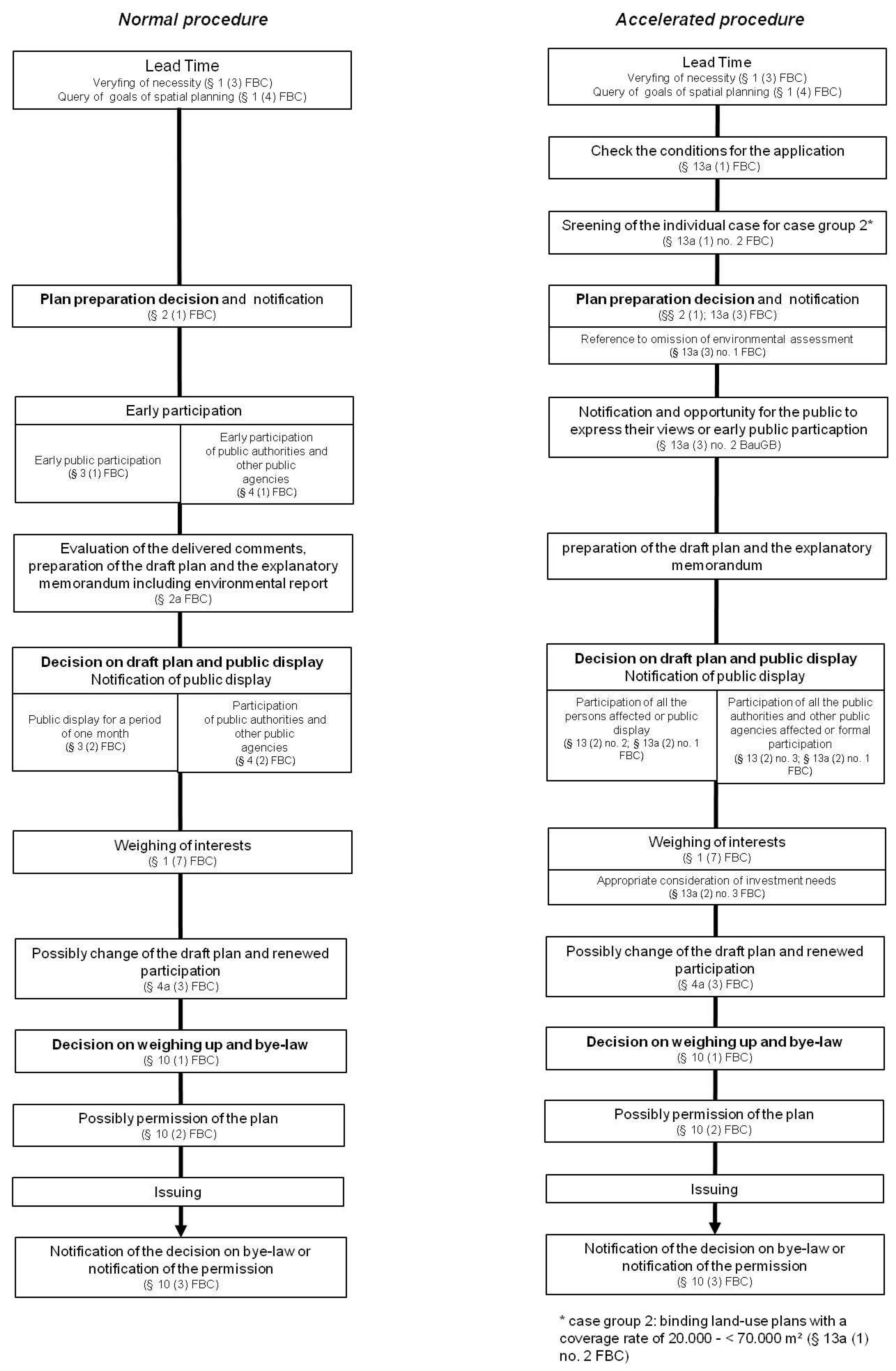
For measures of inner urban development, especially for the reuse of areas, post-urbanization, or other measures of inner urban development, the accelerated procedure can be used. This procedure is only applicable if the allowed plot coverage rate does not exceed the threshold of 20,000 m² (case group 1), or, for a permissible plot coverage rate of 20,000 to 70,000 m2 (case group 2), a prior screening of the individual case comes to the conclusion that the binding land-use plan is unlikely to have any significant environmental impact. Plans with a plot coverage rate of more than 70,000 m2 cannot be set up in the accelerated procedure. This size limitation results from European environmental legislation and is designed to ensure that the plan has no environmental impact. Normally, these are examined by the Strategic Environmental Assessment. The accelerated procedure reserved the European Environmental Assessment obligation.
With the accelerated procedure, some regular procedural steps can be dispensed with. Specifically, the acceleration elements of § 13a FBC compared to the regulatory procedure result from:
  • Non-application of Directive 2001/42/EC of the European Parliament and of the Council of 27 June 2001 on the assessment of the effects of certain plans and programs on the environment → no environmental report, environmental assessment, and monitoring necessary;
  • An ability to waive early participation of public authorities and public agencies;
  • An ability to waive early public participation, but then an alternative opportunity to express their views and to gain further clarification if necessary;
  • Optional implementation of public display, an alternative request for the affected public to comment within a reasonable time;
  • Optional implementation of public authorities’ participation, an alternative request for the affected public authorities to comment within a reasonable time;
  • Renouncement of a separate change procedure of the preparatory land-use plan; instead, a redaction-type adjustment of the preparatory land-use plan by way of correction;
  • Waiver of the intervention regulation and the associated compensation obligation for case group 1 (plot coverage rate < 20,000 m2).
In summary, the accelerated procedure is essentially characterized by the omission of the environmental assessment, a more concentrated participation of public and public authorities, the omission of the compensation obligation for interventions in nature and landscape for case group 1, and a simplified possibility of deviating from the representations of the preparatory land-use plan. A comparison between the regular and the accelerated procedure is shown in Appendix A Figure A1.
Besides the introduction of the accelerated procedure in 2007, two more recent adjustments of the law need to be mentioned. In 2013, the German government enacted the “Law for strengthening the inner development in the cities and municipalities and further development of urban planning law”. With this law, inner urban development should have a general priority over outer development [30]. With another amendment of the Federal Building Code in 2017, the legislature has extended the scope of application of § 13a FBC to binding land-use plans for the inclusion of outer areas [31]. With the new § 13b, the procedural simplifications of § 13a FBC have, therefore, been transferred to a binding land-use plan, which establishes the permissibility of residential uses that connect to the built-up area in context. The application framework is limited to the end of 2021.

3. The Analytical Framework and Theoretical Approach

The analytical framework focuses on the inner versus outer urban development and regular versus accelerated procedure decisions. It approaches these decisions from an economic point of view.

3.1. Decision-Maker and Decisions

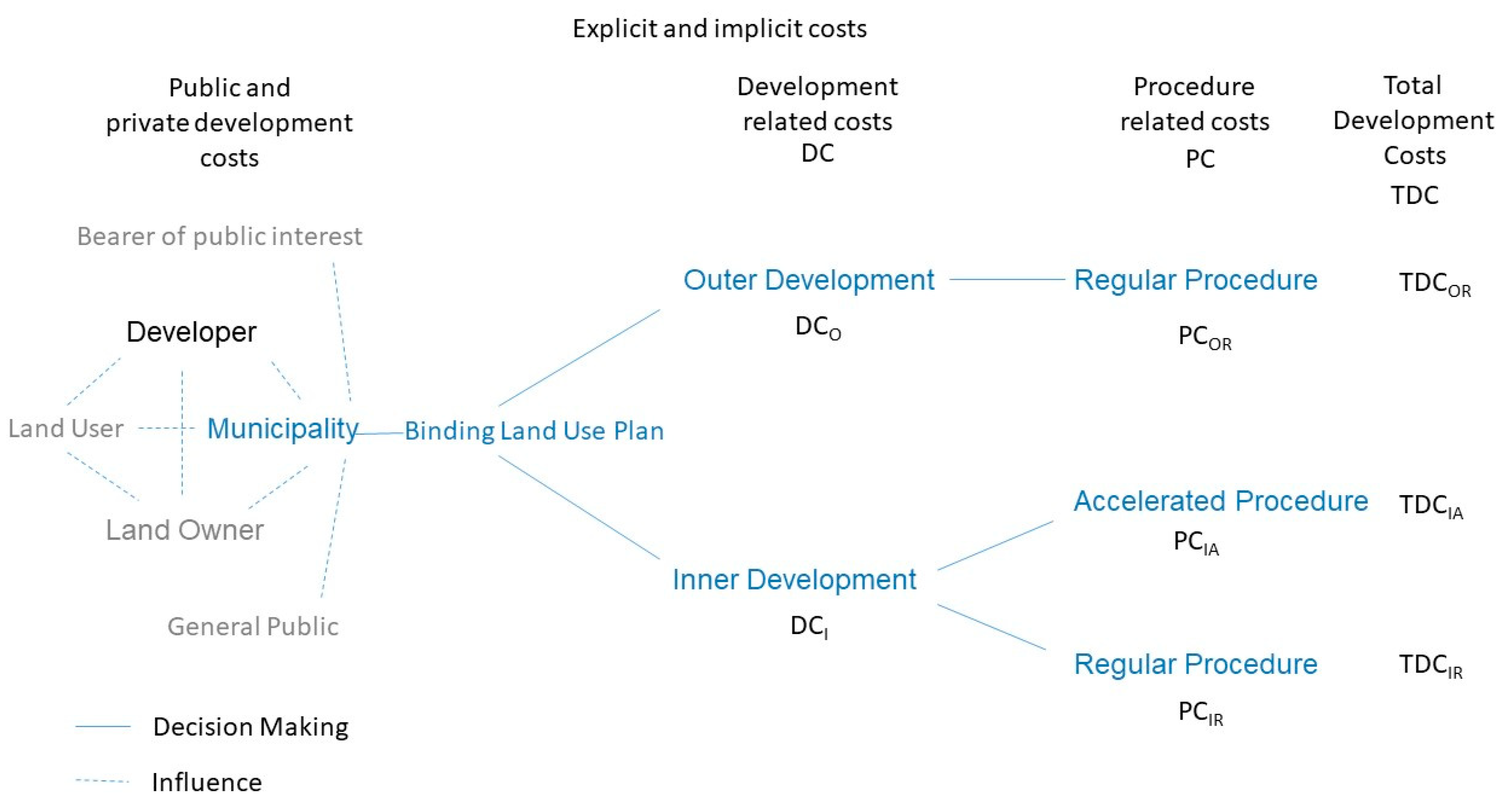
The decision about how to develop a city or a settlement in Germany is, according to § 1 FBC, within the authority of the respective municipality. The municipality decides, among other things, if it will open the procedure for a binding land-use plan in its inner or outer areas. Although the municipality makes the decisions, its behavior is affected by other stakeholders, such as developers, current and potential land users, land owners, and bearers of public interests, including higher-level governments and the general public. Other stakeholders, however, cannot claim any entitlement to the opening of a binding land-use plan.
The decision problem can be analyzed by using a decision tree as shown in Figure 1. The first decision is whether to conduct a binding land-use plan for inner or outer development. If the municipality decides in favor of a binding land-use plan for inner urban development, it can further decide whether to use the accelerated procedure (if the strict conditions of application have been satisfied) or the regular procedure. For outer area development, the regular procedure was required until April 2017. Since then, the accelerated procedure has also been available under certain conditions for cases of outer development. The question now is how far the availability of the accelerated procedure changes the incentives for a municipality to decide in favor of inner urban development.
From an economic point of the view, the expected costs and benefits—and, thus, the net-benefits—for the decision-maker, the municipality, and other stakeholders, but mainly the developer, need to be compared. The benefits of urban land development for the municipality are mainly increased tax revenues in the form of income tax, commercial tax, or land tax. Tax revenues might be captured earlier under the accelerated procedure. The benefit for developers is the increase in the market value of the land. Thus, a profit on a sale of the ready-for-building areas is achieved. This profit margin can be increased by reducing the cost of site preparation by the accelerating and facilitating elements of the accelerated procedure. In order to provide incentives for inner area development, the net-benefits of the accelerated inner development not only need to be higher than the net-benefits of the inner urban development under the regular procedure, but also higher than the net-benefits under the outer area development procedure.
Assuming that benefits are equal, the analysis can be reduced to a comparison of costs.

3.2. Costs of Building Land Development

The real costs of urban land development can be divided into explicit and implicit costs. Explicit costs are tied to financial expenditures, while implicit costs result from the monetary valuation of missed opportunities or from the use of resources that are not paid for. According to Portz [32], the explicit costs of building land development can be subdivided into the following cost items:
  • Procedural and planning costs
    • Administrative costs (personnel and material costs)
    • Costs of planning, including urban design and expert opinions by the awarding of contracts to third parties
  • Land acquisition costs
    • The purchase price of the property plus the land transfer tax
    • Notarial and measuring costs
  • Costs of building land preparation
    • Development costs
    • Costs of ecological compensation
    • Costs of required construction and regulatory measures
  • Subsequent costs
    • Costs of construction and operation of social infrastructure
    • Costs of operating and maintenance of technical infrastructure
Implicit costs are mainly benefits forgone due to lengthy administrative procedures and delays in the process. They can also occur from development disservices that are not compensated for, e.g., adverse effects on the environment that are not part of the ecological compensation.
The magnitude of the explicit and implicit costs of a development project are affected, among other things, by the type of development (inner or outer) and the planning procedure (regular or accelerated). Other factors that partly interact with these two factors are the size of the development, the intended future use (e.g., residential or industrial), and the preceding use (greenfield or brownfield type). For our purpose, it is useful to divide the total development costs (TDCs) into development-related costs (DCs) and procedure-related costs (PCs). Further, fixed and variable costs are usefully distinguished, depending on whether or not a cost item varies with an attribute, e.g., the size of the development.
Finally, it is important to note that the total development costs are borne by different stakeholders, either public or private. The distribution of costs varies depending on the building land development strategy. The payer of explicit costs is either exclusively or proportionally the municipality and/or an investor/developer for the services transferred to him. The implicit costs are borne to different degrees by all parties involved. The sum of explicit and implicit private and public costs minus transfers are usually called social costs.

3.3. Inner versus Outer Urban Development

Assuming equal benefits, the decision of the municipality is assumed to be affected by the total development costs. A settlement expansion into the open landscape is usually easier and quicker to implement than developments in inner-city locations and planning in the existing stock [13,33]. Although the development effort usually increases in an outer area development, the land prices are usually cheaper. Overall, from an investor’s point of view, which mainly includes the explicit cost items 1–3, outer area development is, for the most part, cheaper and less risky [34]. This holds in particular if greenfield development is compared to industrial brownfield development, and less so compared to residential brownfield development [22].
The regeneration of brownfields often causes problems. In addition to the costs for demolition and deforestation measures, the costs of soil remediation for contaminated sites are also significant. Their removal entails a risk for the investor, which is very difficult to calculate due to the direct refurbishment costs and potential deviations from the schedule and from the cash flow planning. Furthermore, in a binding land-use plan for inner urban development, despite ignoring the intervention regulation, there is an increased need for compensation if protected species inhabit the planning area and the recapture of the property by nature has already progressed so far that the trees are to be considered as forest. According to German legislation, this forest distribution is to be replaced separately. These additional costs for the remediation of contaminated sites, the special compensation and clearing of the construction site through demolition and deforestation measures during the reuse of areas, and the associated risks are probably difficult to compensate for through faster and more favorable building law.
From the perspective of the municipality, when taking the explicit subsequent costs (cost item 4) into account, the total development costs changes often in favor of inner urban development [35]. This might also be the case when all explicit and implicit costs (the social costs) for the community are taken into account [23].
The question here is whether or not the introduction of the accelerated procedure changed the decision-making significantly. If the accelerated procedure has cost advantages over the regular procedure, that is PCIR − PCIA > 0, it would be applied to all legally possible cases of inner urban development. However, in order to change the decision-making in favor of inner urban development, the procedural cost advantages, PCOR − PCIA > 0, must be larger than the development cost disadvantages, that is DCI − DCO > 0; thus, the condition (PCOR − PCIA) > (DCI − DCO) must be fulfilled. If this would always be the case, then the total development costs for inner urban development under the accelerated procedure would have the lowest value of all alternatives, TDCIA < TDCIR, TDCOR, and inner urban development would become the dominant development mode. These predictions can be tested empirically by observing the decisions of municipalities before and after the introduction of the accelerated procedure and by measuring the cost differentials, in particular PCR − PCA.

4. Materials and Methods

The Hanseatic City of Stralsund was used as a single case study for the empirical investigation of the effects of the accelerated procedure. Based on a document analysis and semi-structured interviews, we analyzed decisions on inner versus outer urban development before and after the accelerated procedure was introduced. Explicit procedural cost savings were exemplified for one binding land-use plan by counterfactual reasoning, whereas implicit procedural cost savings were evaluated based on a comparison of regular and accelerated procedures. The data collection and analysis took place in 2014 and was updated in 2018.

4.1. Study Site

Stralsund is situated in the north-east of Mecklenburg-Western Pomerania, which is one of the 16 German states and is located in northeastern Germany (Figure 2). This state is overwhelmingly rural and particularly affected by demographic change and a decreasing population [36]. Therefore, the municipalities want to set incentives to retain young families and companies in particular. One such incentive is attractive and inexpensive building land. This increases inter-communal competition for residents and the trend to build in the outer zone. Stralsund has nearly 60,000 inhabitants and a surface area of 54.07 km2. Due to its direct location on the Strelasund, a strait between the city and the holiday island of Rügen, there is a high demand for inner-city or near-urban residential land. The Hanseatic City of Stralsund, a UNESCO World Heritage Site with an eventful history, a unique coastal location, and impressive Brick Gothic architecture, is one of the most popular tourist attractions in Mecklenburg-Western Pomerania. Stralsund is the fourth-largest city of Mecklenburg-Western Pomerania, and, as a part of the central place of highest order of Western-Pomerania, is a model city for the subsequent investigation.

4.2. The Document Analysis of Binding Land-Use Plans and Semi-Structured Interviews

All binding land-use plans for inner urban development as well as all other legally binding land-use plans and inner zone by-laws were viewed and evaluated using a structured document analysis. The plans could be viewed at the department of planning and building inspection of the Hanseatic City of Stralsund; some were also available on the Internet [37]. In the document analysis, framework data (for example, details of the type and duration of the procedure, the size of the planning area, and the form of development) were recorded in a spreadsheet (see Table S1). The binding land-use plans for inner urban development were subjected to a more detailed analysis. For this purpose, the acquisition sheet and semi-structured questionnaire was used (see document S2). Information that could not be obtained from the binding land-use plan for inner urban development was collected by a supplementary survey of employees of the city building department. Here, on the one hand, backgrounds could be identified that did not emerge from the files. On the other hand, personal experiences and assessments of the employees were collected.

4.2.1. The Quantitative Land Development Analysis of the Accelerated Procedure

To evaluate the accelerated procedure in the context of the designation of land-use areas for specific types of use, it is necessary to compare the quantitative land conversion dimension of the inner urban development with that of the outer area development. Therefore, detailed balances of the area that is used for settlement and transport development purposes by binding land-use plans and inner zone by-laws were set up. The investigation period covers the period between the German reunification (1990) and the year 2018. The data were collected in the document analysis. In the case of ambiguity, especially with regard to the original biotope structure and the resulting developmental form, the general urban green structures plans were also used. Changes in binding land-use plans were not taken into account, since the areas were already recorded in the original planning. The annual development of the area that is used for settlement and transport purposes was identified by calculating the area balance of the binding land-use plans and the inner zone by-law for the year the by-law entered into force. The classification key of the Federal Office of Statistics [38] was used to classify the designated areas according to their type of use. Areas that have been designated but that are not part of the settlement and traffic area have not been included. Calculations for the development of the area that is used for settlement and transport purposes, as well as the graphic evaluations, were done in Microsoft (MS) Excel© (Microsoft, Redmond, WA, USA).

4.2.2. The Economic Evaluation of the Accelerated Procedure

The usage of the acceleration elements in Stralsund was recorded in the document analysis. For the economic evaluation of the incentives resulting from the accelerated procedure, the implicit and explicit cost advantages compared to the regular procedure were determined.
The implicit cost advantages were recorded in the document analysis (the period of the procedure from the plan preparation decision to the plan’s announcement in the official journal of the Hanseatic City of Stralsund) and in MS Excel© with the function DATEDIF (date of plan preparation decision, date of announcement, “d”). Thus, the procedural time of the accelerated procedure could be compared with that of the regulatory procedure. In order to ensure a minimum of comparability, the binding land-use plans of the regulatory procedure also had to represent an inner urban development over initial planning after the entry into force of the European Law Adaptation Act for the Construction Sector on 20th July 2004. This ensured that an environmental assessment was carried out. Thus, the duration of five binding land-use plans for inner urban development could be compared with that of five plans in the regular procedure. Statistical studies were omitted due to the small number of cases. A comparison of the duration of the procedure was based on the calculated central value. The median was chosen as the positional parameter, since, unlike the arithmetic mean, it is less influenced by outliers.
The private explicit cost advantages of the accelerated procedure were counterfactually determined by omission of the costs of the individual procedural steps of one case study of investor planning. The costs of the regulatory procedure for the chosen example were determined by reviewing internal contracts. The urban development contract between the Hanseatic City and the project developer, including the offers and bills of the planning office, as well as the contract documents on the external compensatory measures were the basis of the calculation. The basis of calculation for the urban development planning was the Fee Schedule for Architects and Engineers (HOAI) 2009. The fee for the environmental planning services was calculated as a time fee.

5. Results

5.1. The Quantitative Land Development Analysis of the Accelerated Procedure

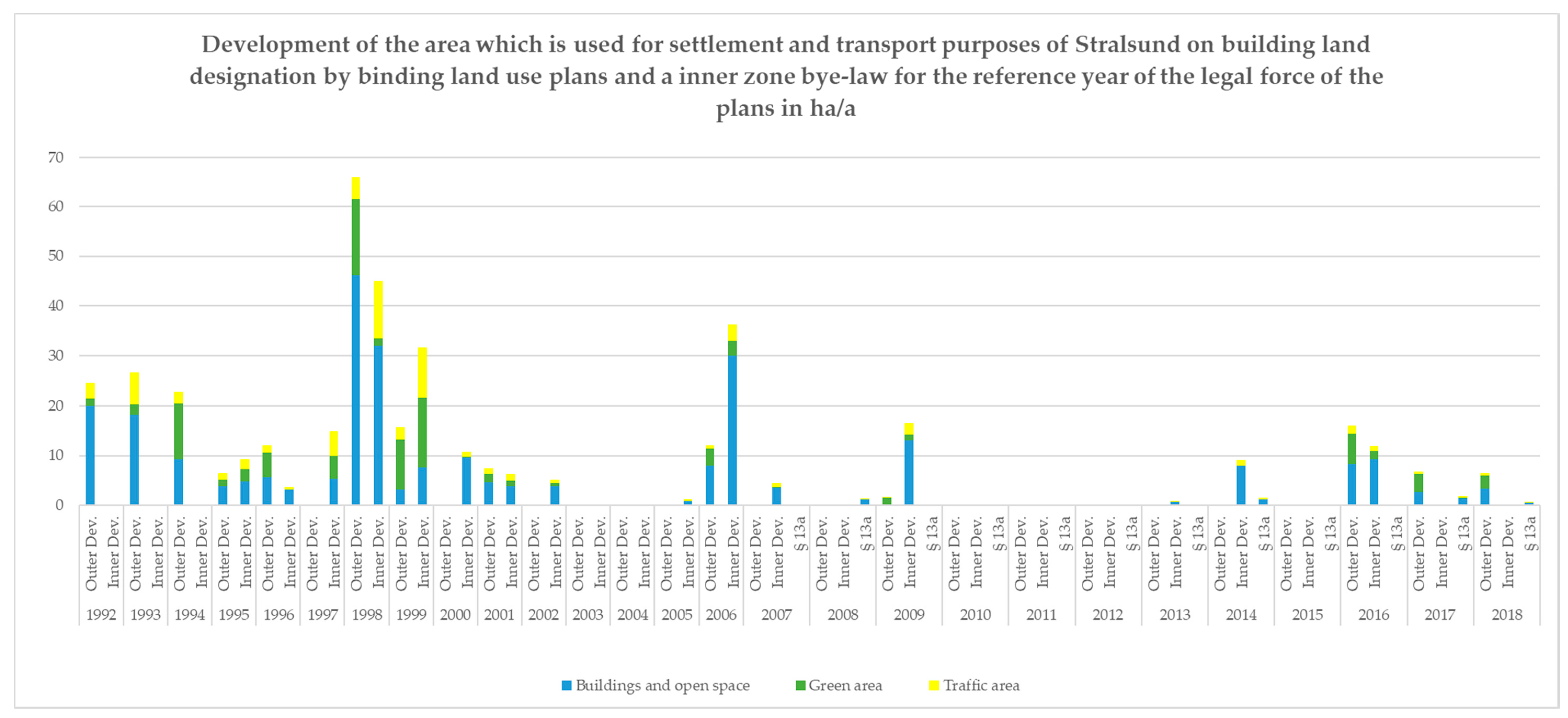
Figure 3 compares the outer and inner urban development of Stralsund in the regular and accelerated procedure (§ 13a) from 1990 (effective since 1992) to 2018. The outer urban development complies with an increase in the area that is used for settlement and transport purposes, while the inner urban development aims at a densification of the area. However, both forms of development contain a small, but not exactly quantifiable, amount of previously developed areas if existing traffic or construction areas are included in the scope of the binding land-use plan.
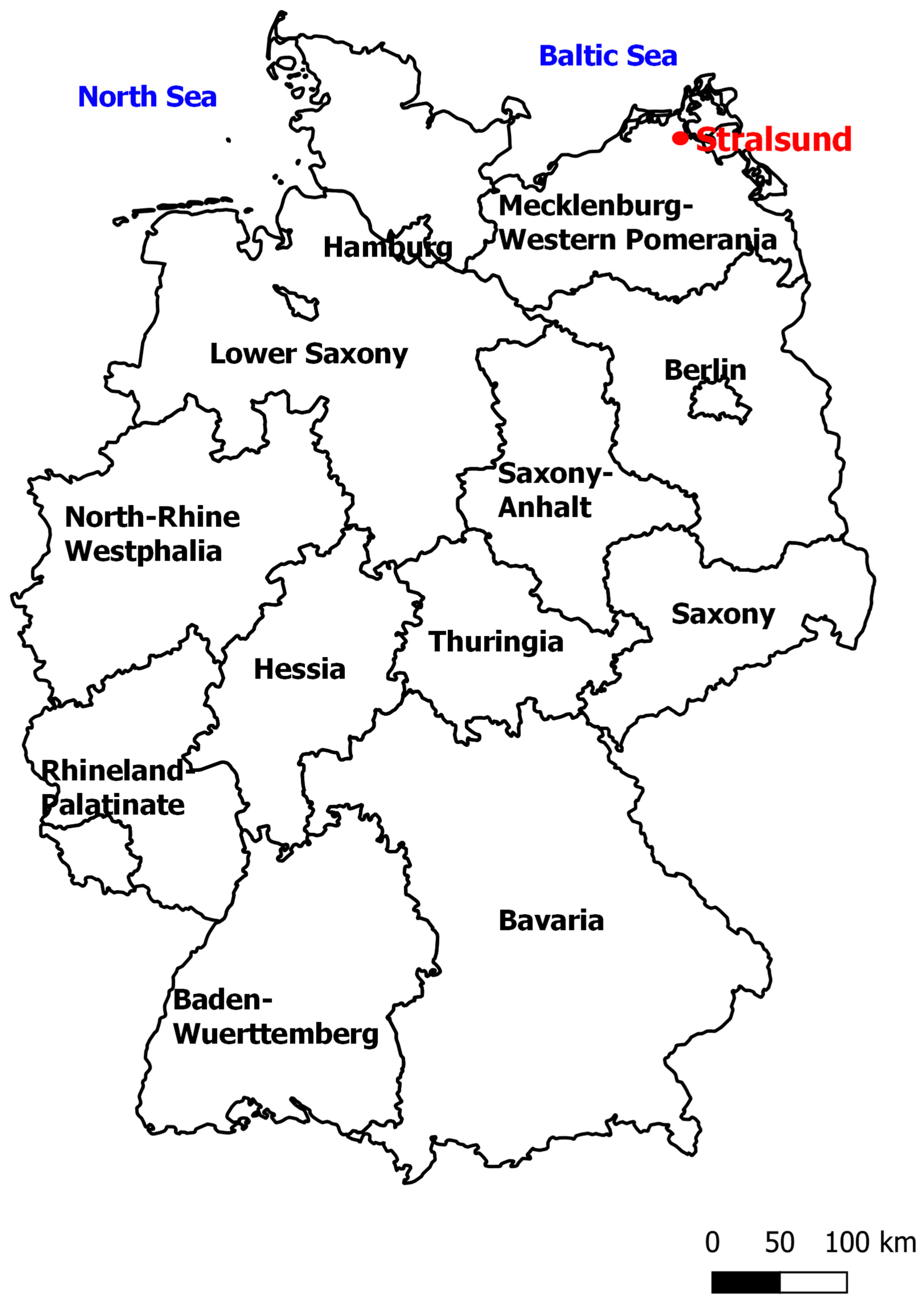
With the German reunification on 3 October 1990, the German system of land-use planning was also transferred to the territory of the former German Democratic Republic. Thus, the then citizenry of the Hanseatic city of Stralsund decided on 6 December 1990 to prepare 13 binding land-use plans and a preparatory land-use plan according to the Federal Building Code. The first plans came into force in 1992, which gives the period of observation since 1990; however, only the period 1992–2018 is taken into account.
As shown in Figure 3, in the first few years after reunification, it was important to mobilize large building areas as quickly as possible. In the first few years, the offer aimed mainly at industrial and commercial building land. This resulted in large commercial and industrial areas on the outskirts of the city. In addition to a demand for commercial building land, there was also a high demand for residential areas; after all, there were about 5000 apartment hunters in Stralsund in the period 1993–1994 [39]. In addition to the lack of rental housing, there was also a lack of favorable building land for private homes. In order to revitalize brownfields due to the collapse of the German Democratic Republic and at the same time to be able to meet the demand for building land, the inner urban development has been increasingly focused on since 1995. As the demand in the 1990s, in addition to rental housing, also aimed at building land for private homes, outer urban development also remained an important instrument for developing attractive residential areas on the outskirts of the city. As a result, the increasing migration of potential homeowners in the surrounding municipalities, which resulted in large population losses at the time [39], could be prevented.
After the turn of the millennium, specific land-use areas were mainly developed via inner urban development. The conversion of brownfields that started in the mid-1990s was further pursued. The inner urban development also took place at the expense of allotment gardens. On 1 January 2007, the binding land-use plans for inner urban development were introduced into planning law. The first decision to introduce an accelerated procedure for a binding land-use plan was taken on 8 March 2007. In July 2008, this first binding land-use plan for inner urban development became legally binding. Since 2007, Stralsund’s inner area has been developed by about 5.5 hectares due to the accelerated procedure, and 0.16 hectares have been added due to a plan change.
Table 1 presents aggregated and additional information for different time periods. In the first period, 1992–1999, outer urban development dominated, while in the second period, 2000–2007, inner urban development gained pace. Since the first binding land-use plans for inner urban development under the accelerated procedure became legally binding in 2008, the third period covers 2008–2018. The designation of building areas is declining as well as the number of binding land-use plans that come into force. The relationship between inner and outer urban development approximately displaces in favor of inner urban development. However, in recent times, outer urban development has again played an increasing role, primarily for the development of residential areas. As regards the use of the accelerated procedure, it can be noted that out of the 11 binding land use plans for inner urban development which came into force from 2008-2018, 5 or 45% were planned under the accelerated procedure. It is also interesting to observe that the average area planned differs between the planning modes. Assuming that plans for mixed development forms equally cover inner and outer areas, the average area planned per procedure in the outer area is 11.5 ha, the average area planned per procedure for inner urban development under the regular procedure is 6.5 ha, and the average area planned per procedure for inner urban development under the accelerated procedure is 1.1 ha.

5.2. Economic Evaluation of the Accelerated Procedure

5.2.1. Explicit Procedural Cost Savings

The explicit cost savings are exemplified by the conversion of a military property in the Hanseatic city of Stralsund that has been idle for about 20 years. The reuse of this fallow land, which is integrated into the settlement area on three sides, represents a classic measure of the inner urban development. Together with the coverage rate of 15,316 m2, the requirements for a binding land-use plan for inner urban development of case group 1 would be given. Exclusion grounds according to § 13a (1) S. 4 and 5 FBC were not available. Primarily for political reasons, the city has nevertheless decided against the accelerated procedure. In the following, the process-relevant cost items of the land preparation for the case example in the regulatory procedure are presented, and potential savings for the investor by using the accelerated procedure are shown. This counterfactual approach is based on the assumption that both planning offices had performed the calculations in the same way and would have received the planning contract from the project developer if the procedure had been accelerated (a ceteris-paribus assumption).
The cost items depending on the type of procedure include planning costs, administrative costs, and the cost of implementing the compensation measures. In an urban development contract (§ 11 FBC), the implementation and financing of the planning services for the binding land-use plan, and the parallel change of the preparatory land-use plan between the developer and Hanseatic city, was regulated. The developer instructed two planning offices on the preparation of urban planning and nature conservation planning.
Internal administration costs, i.e., the personnel and material costs of the municipality, which arise by a binding land-use plan procedure, can be also transferred to the developer to some extent. Since the Hanseatic city of Stralsund has so far not made use of this possibility, the administrative cost savings do not provide any incentives to the developer.
As a result of the project, there was a need for compensatory measures because there were interventions in the natural landscape. In the scope of the binding land-use plan, 6% of the compensation for these interventions was to plant 13 trees and to create a green area, and 94% of the compensation was paid externally by using an eco-account. The green area also served to compensate for protected species. The replacement measures for protected species cannot be counted here as compensation for interventions in the natural landscape. The compensation deficit of 31,000 eco-points was fully covered by the planning.
If the accelerated procedure were to be applied, a total of around €34,300 gross, including additional costs and a value-added tax, could have been saved in a public participation stage and a public agencies participation stage (Table 2). This would have reduced the planning costs by about 26% (about €10,000). The savings amount to around €3100 each through the adaptation of the preparatory land-use plan by way of correction and the omission of the environmental impact assessment, and around €3800 due to the non-requirement of the environmental report for the binding land-use plan and the parallel amendment of the preparatory land-use plan. However, most of the savings are attributable to the omission of the compensation obligation (approximately €24,300).
If the accelerated procedure would have been applied, a private procedural cost saving of 55% would have been possible. In addition to these procedural costs, the developer also has to bear the costs of positions that are independent of the procedure. The costs for the necessary development and construction measures are not insignificant; they amount to almost 2 million Euro (see Table S3). These include, e.g., demolition and process-independent compensatory measures, soil remediation, and infrastructure provision. In addition, there are cost items that are typical of brownfield-reuse (in this case demolition, asbestos disposal, forest compensation, compensation measures for bats, and soil remediation) in the amount of about €795,500 based on the example of a former military property of 55,604 m2 in the Hanseatic City of Stralsund. These costs would not have occurred in an outer urban development. Thus, in this case, the increase in development costs by far exceeds the possible savings in procedural costs.

5.2.2. Implicit Procedural Cost Savings

In addition to direct financial savings through the elimination of process steps, the temporal acceleration of the planning procedure is also an important advantage of the binding land-use plans for inner urban development.
Analyzing the length of the different procedures for binding land-use plans yields the result that the five legally binding land-use plans for inner urban development under the accelerated procedure lasted on average (median) 547 days. In contrast, the five comparative binding land-use plans under the regulatory procedure lasted on average 1042 days (median). This is equivalent to a time saving of 1.4 years or 46%. Although there is a high variation, there is some indication that the accelerated procedure speeds up the process. Due to the low number of observations, no statistical test could be performed.
In the counterfactual assumption that the city had opted for an accelerated procedure in the case of the military site, the planning procedure could probably not have been significantly accelerated according to the Building Office. Since the administrative district, as an approval authority for the change of the zoning plan, did not fully exhaust the inspection period of a quarter of a year that § 6 (4) of the FBC prescribes, considerable delays did not occur. As a result, the deployment process under the regular procedure took only 527 days. This is at least 20 calendar days less than the procedure for an approximately comparable binding land-use plan for inner urban development, despite approximately the same urban design planning requirements but more complex environmental requirements in the case investigation.

5.3. The Evaluation of the Accelerated Procedure from the Perspective of City Administration

All binding land-use plans for inner urban development in the accelerated procedure have a permissible coverage rate of less than 20,000 m2. Thus, case group 2 (section 13a (1) No. 2 FBC) in Stralsund is not applied. According to the city administration, only case group 1 brings an actual procedural advantage. By a preliminary survey in case group 2, which is almost identical to an environmental assessment, and through the required processing of the impact mitigation regulation, neither facilitation nor acceleration is seen. In these cases, the regular procedure is used.
The application of the acceleration possibilities does not often occur. Generally, the public authorities’ early participation is not waived because a loss of this only leads to a slight acceleration of the procedure. Furthermore, the alternative notification and consultation option according to section 13a (3) S. 1 No. 2 FBC is, in the opinion of the planning office, difficult to realize. In addition, the risk of rescheduling increases. The only exception was a development plan change with a scope of less than 2000 m2. Here, the extent to which the public and the public agencies were concerned as well as the impact of the plan change were so clear and marginal that a waiver of the early participation seemed to be justifiable.
However, the participation of the public and public agencies has always taken place as a public display or as formal participation in accordance with §§ 3 (2) and 4 (2) of the FBC in order to increase legal certainty. Thus, in particular, the “affected public” according to § 13 (2) S. 1 No. 2 is often difficult to define. Overall, legal certainty for the administration is a great good, which outweighs a slight acceleration of the procedure.
According to the city administration, most of the areas of the binding land-use plans for inner urban development would have been developed without the accelerated procedure, and the development would not have taken place elsewhere. Only for one plan out of 17 was it stated that the development would not have taken place without the accelerated procedure. This can also be justified by the fact that the procedure is seen by the building authority as a “nice facilitation”, which is “not decisive” for the development of areas.

6. Discussion

6.1. The Incentives Generated by the Accelerated Procedure

The accelerated procedure aims to reduce costs for developers and public administrations and by doing so it intends to create incentives for inner urban development. As the analysis of one case study of inner urban development has shown, the explicit private procedural cost savings could have amounted to approximately €34,000, which is 55% of the procedure-related private explicit costs. The planning-related savings were 29%, and the ecological-compensation-related savings were 100%. The numbers are in line with a previous study, which estimated planning cost savings of 20–40% [16]. However, in this case, the municipality decided against the accelerated procedure. One reason is that the application of the accelerated procedure would have created private benefits (reduced explicit private costs) at the expense of increased public implicit costs (reduced ecological compensation), which is difficult to justify politically. From the developer’s perspective, the potential cost savings were rather marginal. In relation to the other estimated development costs of around 2 million Euro, the savings are only 1.7% of the total, and they are well-below the additional brownfield-related explicit costs (€34,000 < €795,500). Thus, if other alternatives would have been available, it is likely that this area would not have been developed. To be sure, there are many case-specific influencing factors. The explicit cost saved might be much higher and the brownfield-related costs lower in the case of residential brownfields than in the analyzed case of military brownfields. However, other cases could not be analyzed in detail within this study.
In terms of implicit costs and time savings, the accelerated procedure seems to speed up the process by almost 1.5 years, or 46%; however, a huge variation could be observed. Thus, there are many other factors that affect the time needed for a binding land-use plan to become effective. However, the calculated average time savings are also in line with the literature, which reported time savings of 30–50% [16]. Thus, the implicit cost savings might be the main reason why, since 2007, the building authorities of Stralsund have applied the accelerated procedure in the majority of cases of inner area development.
Overall, however, an evaluation of the implicit savings turns out to be extremely difficult. This results from the individual case character of each binding land-use plan procedure in that a large number of parameters interact. Above all, the urgency and the (political) interest in planning play a decisive role. These parameters are independent of the type of procedure. Decisive for the duration of procedures are, above all, the combination and the cumulative existence of positive or negative framework conditions. However, a particularly long procedure may also result from individual conflicting factors. Ultimately, many of the planning requirements are defined only by identifying and assessing the issues involved in the process, in particular through the participation of public authorities [33].
The incentives to use the accelerated procedure for inner urban development seem also to be related to the size of the area. Smaller areas are more likely to be planned under the accelerated procedure. Partly, this is related to the legal framework, but there might also be strong economic forces at work. Planning procedures often include significant fixed costs. If the accelerated procedure saves mainly on fixed costs, the relative advantage of the accelerated procedure over the regular procedure increases as the size of the area decreases.

6.2. The Effect of the Accelerated Procedure on the Quantitative Land Development

The final objective of the accelerated procedure is to shift the development to the inner area in order to reduce farmland or open green space conversion in the outer area. As shown in the analysis of the quantitative land development for the city of Stralsund, there was already a shift in the development of the inner area in 1999, which is long before the accelerated procedure came into force in 2007. During the period between 2000 and 2007, the development of the inner area was particularly pronounced. Also, in the years after the introduction of the accelerated procedure, the development mainly occurred in the inner area until the year 2016, when outer area development again began to dominate. Over the whole period from 1992 to 2018, the land development in the outer and inner areas was almost equal. Thus, we cannot observe a strong quantitative effect of the change in the law for Stralsund. The discussion about the preference for inner area development had started earlier, and the city started to change the policy earlier, than the change in the legal environment. This is consistent with the already-mentioned statement of the administration that most of the areas of the binding land-use plans of inner urban development would have been developed without the accelerated procedure and the development would not have taken place elsewhere. Only for 1 out of 17 binding land-use plans for inner urban development that were established under the accelerated procedure was the accelerated procedure regarded as decisive, which is 5.9% Thus, our results confirm those in the previous literature. According to Siedentop et al. [17], only 6% of the binding land-use plans for inner urban development would not have been established without the procedure. In addition to the previous literature, we are able to assess the land development impact in quantitative terms. The inner area that has been developed under the accelerated procedure from 2008 to 2018 is 5.47 ha. Thus, we can roughly estimate that, without the accelerated procedure, only 0.3 ha of the inner area of Stralsund would not have been developed.
The city had already given preference to inner urban development in the late 1990s, and it seems that the change in the legal environment only supported this city policy. This, however, has changed since 2016, when outer area development gained pace. There at least two reasons for this development. First, it is becoming increasingly difficult for inner urban development to supply the demand for building areas. Second, with the amendment of the Federal Building Code in 2017, the scope of application of § 13a FBC to binding land-use plans has been extended to include outer areas. The new procedure creates temporary incentives for facilitating outer urban development and even reduces incentives for inner urban development.
The objective of 30 ha per day in a country of 357,385.71 km2 such as Germany means, for a city of 54.07 km2 such as Stralsund, land conversion for settlement and traffic in the outer area of 1.66 ha per year. The land conversion rate in the period 2008–2018 was on average about 2.8 ha per year with an increasing trend. Thus, since similar developments are likely to occur in other cities all over Germany, the 30 hectare target will certainly not be achieved in the near future.

7. Conclusions

The aim of this paper was to assess the extent to which the accelerated procedure contributes to increased inner urban development by providing incentives for the reuse of vacant developed land, which are often contaminated sites. The results reveal that, although the city of Stralsund since 2017 has widely applied the accelerated procedure for small scale projects of inner urban development, the effect of the accelerated procedure on increased inner urban development has been very limited. The city had already given preference to inner urban development in the late 1990s, and it seems that the change in the legal environment only supported this city policy. Thus, the main effect of the accelerated procedure has been a reduction of the administrative burden for developers and public administration. In what follows, we will draw some conclusions for policy and further research.

7.1. Policy Implications

The accelerated procedure highlights the dilemma of conflicting policy objectives. The accelerated procedure should contribute to the containment of cities, reduce the administrative burden, increase competitiveness, and contribute to the supply of housing. Surely not all objectives can be achieved with one policy at the same time [40]. The accelerated procedure mainly reduced the administrative burden for developers and public administrations for small scale development projects, and to a rather small extent contributes to the containment of cities. Currently, politicians prioritize development for housing at the expense of achieving the land conversion target.
Since the introduction of the 30 ha per day objective, there has been an intense debate about an adequate policy to achieve this objective. Economists have mainly promoted economic instruments, such as the introduction of a development tax or tradable development permits [41,42]. However, so far, the German government has not introduced economic instruments, but has mainly used legal and planning instruments by adjusting the planning and building laws, such as the FBC [43,44]. Also, the government has provided information and promoted the cooperation of municipalities on land conversion issues.
This raises the question of whether other instruments need to be applied in order to achieve the policy objective. Tradable development permits are an instrument that can be targeted to reach quantitative objectives. If development rights of 30 ha per day would be equally distributed over the surface area of Germany, it would allow the city of Stralsund to develop 1.66 ha per year in the outer area, compared to 2.8 ha per year over the last 10 years. Although such a policy is very appealing from an economic point of view, it is questionable whether or not it is politically feasible and socially acceptable. However, the more poorly other instruments perform, the higher the demand for effective policy instruments might be.

7.2. Further Research

This study was conducted as a single case study of the mid-sized city of Stralsund in the North-Eastern part of Germany. Besides reviewing all binding land-use plans from 1990 to 2018, some results were further obtained from the analysis of just one binding land-use plan of a brownfield development, and others for the comparison of a small number of binding land-use plans under different procedures. Although the results cannot be generalized, they are very much in line with the results obtained by the previous literature [16,17]. While the previous literature mainly used a cross-sectional research design, we built on a time series and could investigate long-term changes and the quantitative dimension of land-use planning, including before and after changes. Since we know of no similar study, we cannot compare these results. The developments we observe in Stralsund for the quantitative dimension of land use are quite common for cities in East Germany, but less so for West Germany.
The screening of binding land-use plans can be considered as quite useful and allows us to present a detailed picture about the land development in different areas over time. A similar approach was conducted by Siedentop et al. [17]. All screening documents and questionnaires are available in the supplemental material, so that the research could be easily replicated in other cities. A higher number of observations may allow us to test empirically the extent to which the accelerated procedures saves on implicit and explicit costs. Calculating all implicit and explicit private and public costs of different procedures requires a lot of effort. In this study, only one binding land-use plan could be investigated in detail. It would be desirable to increase the number of detailed cases, and analyze statistically or econometrically either the factors that drive the costs of binding land-use plans, such as Dillmann and Zemke [33], or factors that affect the choice of the planning procedure, such as, for instance, Tan et al. [45].
Finally, we think that the results obtained from the case study of the Hanseatic city of Stralsund can serve as a relevant reference point for similar studies on the containment of cities in Germany, in Europe, or even worldwide.

Supplementary Materials

The following are available online at https://www.mdpi.com/2071-1050/10/12/4745/s1, Table S1: Table for the acquisition of binding land use plans and inner zone bye-laws, Document S2: Registration sheet for the binding land use plans for inner urban development, complementary to table for acquisition, Table S3: Non-procedural private costs for the land development case for the example of a former military property of 55,604 m² in the Hanseatic City of Stralsund.

Author Contributions

Oliver Dillmann and Volker Beckmann conceived and designed the study; Oliver Dillmann gathered and analyzed the data; Oliver Dillmann and Volker Beckmann wrote the paper.

Funding

The research received no external funding.

Acknowledgments

The authors thank the Hanseatic City of Stralsund for its support to conduct the study. We would also like to thank the three anonymous reviewers for their valuable comments.

Conflicts of Interest

The authors declare no conflicts of interest.

Appendix A

Figure A1. Comparison between Regular and Accelerated Procedure.
Sustainability 10 04745 g0a1

References

  1. Tan, R.; Beckmann, V.; van den Berg, L.; Qu, F. Governing farmland conversion: Comparing China with the Netherlands and Germany. Land Use Policy 2009, 26, 961–974. [Google Scholar] [CrossRef]
  2. Azadi, H.; Ho, P.; Hasfiati, L. Agricultural land conversion drivers: A comparison between less developed, developing and developed countries. Land Degrad. Dev. 2011, 22, 596–604. [Google Scholar] [CrossRef]
  3. Priebs, A. Raumordnung in Deutschland; Westermann: Braunschweig, Germany, 2013. [Google Scholar]
  4. Umweltbundesamt (UBA). Siedlungs- und Verkehrsfläche. 2018. Available online: https://www.umweltbundesamt.de/daten/flaeche-boden-land-oekosysteme/flaeche/siedlungs-verkehrsflaeche (accessed on 30 June 2018).
  5. Pahl-Weber, E.; Henckel, D. (Eds.) The Planning System and Planning Terms in Germany: A Glossary; Akad. für Raumforschung und Landesplanung: Hannover, Germany, 2008. [Google Scholar]
  6. Siedentop, S. Einflussfaktoren der Neuinanspruchnahme von Flächen: Ein Projekt des Forschungsprogramms “Allgemeine Ressortforschung” des Bundesministeriums für Verkehr, Bau und Stadtentwicklung (BMVBS) und des Bundesinstituts für Bau-, Stadt- und Raumforschung (BBSR) im Bundesamt für Bauwesen und Raumordnung (BBR); Bundesamt für Bauwesen und Raumordnung: Bonn, Germany, 2009. [Google Scholar]
  7. Liu, L.-J.; Song, M.; Yokogawa, H.; Qu, B.-X. Exploring the Environmental Kuznets Curve Hypothesis between Economic Growth and Farmland Conversion in China. J. Fac. Agric. Kyushu Univ. 2008, 53, 321–327. [Google Scholar]
  8. Colsaet, A.; Laurans, Y.; Levrel, H. What drives land take and urban land expansion? A systematic review. Land Use Policy 2018, 79, 339–349. [Google Scholar] [CrossRef]
  9. Lichtenberg, E.; Ding, C. Local officials as land developers: Urban spatial expansion in China. J. Urban Econ. 2009, 66, 57–64. [Google Scholar] [CrossRef]
  10. Bundesregierung, Die. Perspektiven für Deutschland: Unsere Strategie für eine nachhaltige Entwicklung; Die Bundesregierung: Berlin, Germany, 2002.
  11. Bundesregierung, Die. Deutsche Nachhaltigkeitsstrategie—Neuauflage 2016; Die Bundesregierung: Berlin, Germany, 2016.
  12. Deutscher Bundestag. Entwurf eines Gesetzes zur Erleichterung von Planungsvorhaben für die Innenentwicklung der Städte; Deutscher Bundestag: Berlin, Germany, 2006. [Google Scholar]
  13. Ganser, R. Innenentwicklung durch Bebauungsplanung. RaumPlanung 2017, 190, 8–13. [Google Scholar]
  14. Krautzberger, M. Der Bebauungsplan der Innenentwicklung (§ 13a BauGB) im Lichte der aktuellen Rechtsprechung. DVBl 2014, 5, 270–275. [Google Scholar]
  15. Tomerius, S. Auswirkungen der Baugesetzbuch-Novelle 2007—Impulse für mehr Innenentwicklung und Flächensparen in den Gemeinden? Z. Umweltr. 2008, 19, 1–7. [Google Scholar]
  16. Jachmann, S.; Mitschang, S. Bebauungspläne der Innenentwicklung—Studie zur Anwendung von §13a BauGB in der kommunalen Planungspraxis. BauR Baurecht 2009, 40, 913–927. [Google Scholar]
  17. Siedentop, S.; Krause-Junk, K.; Junesch, R.; Fina, S. Nachhaltige Innenentwicklung Durch Beschleunigte Planung? Analyse der Anwendung von § 13a BauGB in Baden-Würtembergischen Kommunen; Landesanstalt für Umwelt Baden-Würtemberg: Stuttgart, Germany, 2010. [Google Scholar]
  18. Wolff, M.; Haase, D.; Haase, A. Compact or spread? A quantitative spatial model of urban areas in Europe since 1990. PLoS ONE 2018, 13, e0192326. [Google Scholar] [CrossRef]
  19. McConnell, V.; Wiley, K. Infill Development: Perspectives and Evidence from Economics and Planning; Resources for Future: Washington, DC, USA, 2010. [Google Scholar]
  20. Breheny, M. Urban compaction: Feasible and acceptable? Cities 1997, 14, 209–217. [Google Scholar] [CrossRef]
  21. Bartke, S.; Schwarze, R. No perfect tools: Trade-offs of sustainability principles and user requirements in designing support tools for land-use decisions between greenfields and brownfields. J. Environ. Manag. 2015, 153, 11–24. [Google Scholar] [CrossRef] [PubMed]
  22. De Sousa, C. Brownfield Redevelopment versus Greenfield Development: A Private Sector Perspective on the Costs and Risks Associated with Brownfield Redevelopment in the Greater Toronto Area. J. Environ. Plan. Manag. 2000, 43, 831–853. [Google Scholar] [CrossRef]
  23. De Sousa, C.A. Measuring the Public Costs and Benefits of Brownfield versus Greenfield Development in the Greater Toronto Area. Environ. Plan. B Plan. Des. 2002, 29, 251–280. [Google Scholar] [CrossRef]
  24. Thornton, G.; Franz, M.; Edwards, D.; Pahlen, G.; Nathanail, P. The challenge of sustainability: Incentives for brownfield regeneration in Europe. Environ. Sci. Policy 2007, 10, 116–134. [Google Scholar] [CrossRef]
  25. Ganser, R.; Mattei, J. Towards a more effective use of land: Combining planning and fiscal powers. Lett. Spat. Resour. Sci. 2018, 11, 85–93. [Google Scholar] [CrossRef]
  26. Jessel, B.; Berg, K.; Bielfeldt, H.-R.; Kahl, M. Umweltprüfung von Bebauungsplänen der Innenentwicklung: Eine Kritik des aktuellen BauGB-Entwurfs. Naturschutz Landschaftsplanung 2006, 38, 269–275. [Google Scholar]
  27. World Bank. Dealing with construction permits. In Doing Business; World Bank: Washington, DC, USA, 2014; pp. 77–81. [Google Scholar]
  28. Spannowsky, W. Die Einführung eines beschleunigten Verfahrens für Bebauungspläne der Innenentwicklung. Natur Recht 2007, 29, 521–526. [Google Scholar] [CrossRef]
  29. Hansson, A.G. Promoting planning for housing development: What can Sweden learn from Germany? Land Use Policy 2017, 64, 470–478. [Google Scholar] [CrossRef]
  30. Hagebölling, C. Das Gesetz zur Stärkung der Innenentwicklung in den Städten und Gemeinden und weiteren Fortentwicklung des Städtebaurechts. Natur Recht 2013, 35, 99–105. [Google Scholar] [CrossRef]
  31. Von Nicolai, H. Die BauGB- und BauNVO-Novelle zum neuen Zusammenleben in der Stadt. NordÖR 2017, 9, 369–376. [Google Scholar]
  32. Portz, N. Die Bedeutung ökonomischer und finanzieller Aspekte des Städtebaurechts für die Gemeinden. In Ökonomische und Finanzielle Aspekte des Städtebaurechts; Spannowsky, W., Hofmeister, A., Eds.; Heymanns: Kaiserslautern, Germany, 2005; pp. 1–12. [Google Scholar]
  33. Dillmann, O.; Zemke, R. Welche Determinanten bestimmen die Dauer von Verfahren der verbindlichen Bauleitplanung? BauR Baurecht 2018, 49, 1349–1358. [Google Scholar]
  34. Umweltbundesamt. Das Kostenparadoxon der Baulandentwicklung: Von der Außen- zur Innenentwicklung in Städten und Gemeinden—Erarbeitung von Handlungsvorschlägen sowie Analysen der Ökologischen, Ökonomischen und Sozialen Wirkungen einer Neuorientierung der Siedlungspolitik; Umweltbundesamt: Dessau-Roßlau, Germany, 2009. [Google Scholar]
  35. Preuß, T.; Floeting, H. (Eds.) Folgekosten der Siedlungsentwicklung: Bewertungsansätze, Modelle und Werkzeuge der Kosten-Nutzen-Betrachtung; Deutsches Institut für Urbanistik GmbH (Difu): Berlin, Germany, 2009. [Google Scholar]
  36. Statistische Ämter des Bundes und der Länder. Demografischer Wandel in Deutschland, Heft 1, 2011; Statistische Ämter des Bundes und der Länder: Wiesbaden, Germany, 2011. [Google Scholar]
  37. Hansestadt Stralsund. Rechtskräftige Bebauungspläne der Hansestadt Stralsund. 2018. Available online: https://www.stralsund.de/buerger/leben_in_stralsund/Planen_Bauen_Wohnen/Bauen_und_Wohnen/Bebauungsplaene/ (accessed on 30 November 2018).
  38. Statistisches Bundesamt. Land- und Forstwirtschaft, Fischerei. Bodenfläche nach Art der Tatsächlichen Nutzung; Statistisches Bundesamt: Wiesbaden, Germany, 2016. [Google Scholar]
  39. Hansestadt Stralsund. Bebauungsplan Nr. 41 “Kleiner Wiesenweg—Nördlicher Teil”. Begründung; Hansestadt Stralsund: Stralsund, Germany, 1998. [Google Scholar]
  40. Tian, C.; Fang, L. The Impossible in China’s Homestead Management: Free Access, Marketization and Settlement Containment. Sustainability 2018, 10, 798. [Google Scholar] [CrossRef]
  41. Proeger, T.; Meub, L.; Bizer, K. Laboratory Experiments of Tradable Development Rights: A Synthesis of Different Treatments. Sustainability 2018, 10, 1972. [Google Scholar] [CrossRef]
  42. Nuissl, H.; Schroeter-Schlaack, C. On the economic approach to the containment of land consumption. Environ. Sci. Policy 2009, 12, 270–280. [Google Scholar] [CrossRef]
  43. Hausmann, M. Planungsrechtliche Instrumente zur Steuerung der Innenentwicklung: §9 Abs. 2a, §13a und §34 BauGB in der Praxis; Bachelorarbeit: Hamburg, Germany, 2012. [Google Scholar]
  44. Schulz, A. Reduzierung des Flächenverbrauchs mit Hilfe der Bauleitplanung; LIT Verlag: Münster, Germany, 2017. [Google Scholar]
  45. Tan, R.; Beckmann, V.; Qu, F.; Wu, C. Governing Farmland Conversion for Urban Development from the Perspective of Transaction Cost Economics. Urban Stud. 2012, 49, 2265–2283. [Google Scholar] [CrossRef]
Figure 1. The Analytical Framework.
Sustainability 10 04745 g001
Figure 2. The Hanseatic city of Stralsund in Germany (Scale: 1:5,000,000).
Sustainability 10 04745 g002
Figure 3. The annual development of the area that is used for settlement and transport purposes in Stralsund by building land designation.
Sustainability 10 04745 g003
Table 1. A summary of the development of the area that has been used for settlement and transport purposes by building land designation in Stralsund since the German unification in 1990 (due to the duration of the proceedings presented from 1992).
Period Attribute1992–19992000–20072008–2018 (Differing Period)1992–2018
∑ Outer urban development (ha)1742031225
∑ Inner urban development (ha)1056444213
∑ Inner urban development with the accelerated Procedure § 13a (ha)--5.475.47
Proportion outer to inner urban development5:31:31:1.41:1
Average annual outer urban development (ha)21.752.52.88.33
Average annual inner urban development (ha)13.12584.07.89
Number of approved legally binding land-use plans23201558
Number of binding land-use plans for outer urban development121316
Number of binding land-use plans for inner urban development (without § 13a)915630
Number of binding land-use plans with a mixed developmental form2417
Number of binding land-use plans with the accelerated procedure § 13a--55
Table 2. A comparison of the private procedural costs in the regular procedure and in the accelerated procedure according to § 13a of the Federal Building Code (FBC) based on the example of a former military property of 55,604 m2 in the Hanseatic City of Stralsund.
Cost ItemCosts of the Regular ProcedureEstimated Costs by Establishment of the Accelerated Procedure
A) Gross planning costs37,870.7827,885.51
Gross costs of urban planning21,289.9118,189.39
Binding land-use plan (net)14,42014,420
Change of preparatory land-use plan (net)24580
Gross costs of nature conservation planning16,580.879696.12
Open space plan (net)69104430
Species protection survey (net)12301230
Accompaniment of the procedure (net)21002100 *
Environmental report (net)30300
B) Gross costs of compensation24,2920
Internal compensation by planting 13 trees á ca. 410 € grossca. 53300
External compensation by an eco-account (gross)18,9620
A+B) Total Private Procedural Costs62,162.7827,885.51
* If the procedure for changing the F-plan is omitted, unquantifiable savings are possible here.

