Review

Earth Observation-Based Operational Estimation of Soil Moisture and Evapotranspiration for Agricultural Crops in Support of Sustainable Water Management

by
George P. Petropoulos
1,2,*,
Prashant K. Srivastava
3,
Maria Piles
4 and
Simon Pearson
5
1
Department of Geography and Earth Sciences, University of Aberystwyth, Wales SY23 2DB, UK
2
School of Mineral Resources Engineering, Technical University of Crete, 73100 Chania, Greece
3
Institute of Environment and Sustainable Development, Banaras Hindu University, Varanasi 221005, India
4
Image Processing Lab (IPL), Universitat de València, 46980 València, Spain
5
Lincoln Institute for Agri-Food Technology, The University of Lincoln, Lincoln LN6 7TS, UK
*
Author to whom correspondence should be addressed.
Sustainability 2018, 10(1), 181; https://doi.org/10.3390/su10010181
Submission received: 28 November 2017 / Revised: 22 December 2017 / Accepted: 28 December 2017 / Published: 12 January 2018

Abstract

:
Global information on the spatio-temporal variation of parameters driving the Earth’s terrestrial water and energy cycles, such as evapotranspiration (ET) rates and surface soil moisture (SSM), is of key significance. The water and energy cycles underpin global food and water security and need to be fully understood as the climate changes. In the last few decades, Earth Observation (EO) technology has played an increasingly important role in determining both ET and SSM. This paper reviews the state of the art in the use specifically of operational EO of both ET and SSM estimates. We discuss the key technical and operational considerations to derive accurate estimates of those parameters from space. The review suggests significant progress has been made in the recent years in retrieving ET and SSM operationally; yet, further work is required to optimize parameter accuracy and to improve the operational capability of services developed using EO data. Emerging applications on which ET/SSM operational products may be included in the context specifically in relation to agriculture are also highlighted; the operational use of those operational products in such applications remains to be seen.

1. Introduction

Water secures livelihoods and economic growth. Agriculture alone consumes 70% of global fresh water [1,2]. As global population and the human desire for a higher protein diet grows, pressure on the world’s scarce water supply will increase. This pressure and demand for water shows a high geographic variance and there is no doubt that global droughts but also flood risk, are threatening regional food security. These risks are reflected in the Davos Risk Register [3] that rates “water crises” as the 3rd highest global risk for impact. Furthermore, agriculture is competing with industrial, household and environmental users for scarce water supply [4]. These demands combined with the potential forward impact of climate change demonstrate that there is an urgent need to garner a better understanding of the natural processes driving the global hydrological cycle [5,6,7]. In particular, more exact information on the spatio-temporal variation of parameters such as surface soil moisture (SSM) and evapotranspiration (ET) rates are of key significance. Specifically, these parameters exert a strong control on the Earth’s water, carbon cycles and ecosystem functioning [8,9]. Tools to quantify both ET and SSM have a crucial role in understanding the Earth’s climatic system on the longer term but by enabling increased water use efficiency they can also have significant economic, environmental and social impact on the shorter term. For the latter, data is required at high spatial and temporal resolutions to inform decision makers on sustainable utilisation and management of water [10].
There are numerous techniques available to derive SSM and ET using ground instrumentation. Ground measurements have certain advantages, such as providing a relatively direct measurement, instrument portability, simple installation, operation and maintenance, the ability to provide measurement at the desired depth and also the relative maturity and stability of the methods. Nevertheless, such techniques have proven difficult to implement, especially over large areas. This reflects the complex, expensive and labour-intensive challenges in deploying a network of in-situ sensors at a study site. In addition, current field equipment typically determines only localized estimates of SSM which must be aggregated for measuring the parameter over large spatial scales. The placement of the in-situ sensors is then key to obtain representative estimates [11]. Various ground-based observational networks have been established in basins of different characteristics around the globe, aiming to systematically collect, archive and distribute a wide variety of relevant data for use in research activities [12,13]. A review of the available ground-based methods including their relative strengths and limitations and available operational networks can be found in [14,15].
Conversely, the advent of Earth Observation (EO) technology has provided novel and economically feasible means to derive temporally consistent coverage of ET and SSM at different spatial scales [16,17,18]. EO provides regional to global scale parameter estimation and enables non-invasive synoptic views in a spatially contiguous fashion, providing estimates from otherwise inaccessible regions. Another advantage is that observations can be obtained over remote areas which are otherwise inaccessible for in-situ measurements. In addition, the development of EO has enabled the scientific community to investigate previously unsolvable problems, such as spatial variability and scale of observation [19]. These are the main characteristics that make EO one of the most efficient and cost-effective techniques for obtaining spatio-temporal estimates of ET as well as of SSM [20,21].
Remote sensing instruments do not directly measure either soil water content and/or the turbulent heat fluxes. The spectral measures they provide have to be combined with a physical or semi-empirical model and an inversion algorithm in order to estimate the parameters. A plethora of retrieval methods have been proposed for estimating spatially distributed ET and SSM utilising spectral information acquired in selected regions of the electromagnetic radiation spectrum; often combined with ancillary surface and atmospheric observations. Those techniques are well understood but each has atypical strengths and weaknesses, see recent reviews [20,21,22]. Some of those approaches have shown promising potential for providing accurate estimates of spatial-temporal estimates of surface heat fluxes and SSM, with accuracies reported in the ranges of 50 Wm−2 and of 0.04 m3·m−3 respectively; accuracy levels required by many applications [23]. At present, there are several operational products available providing ET and SSM estimates, each with their own strengths and limitations.
In light of the above, this paper aims at providing an overview of the state of the art of EO techniques to derive operational estimates of both ET and SSM. In this context, we critically discuss the challenges and caveats associated with the derivation of accurate estimates of ET and SSM parameters from space. We make suggestions on how future work should be directed to enhance the accuracy and operational capability of services developed using EO data. The paper closes with a reflective discussion on how existing or future EO operational products could lead to new applications related specifically to attain more sustainable agricultural practices, which is of the utmost importance since agriculture is the world’s largest consumer of fresh water.

2. Operational Retrievals of ET from EO

2.1. Methods for ET Retrievals from EO

The prospect and capability of EO technology in deriving regional maps of ET fluxes became available first in 1972 with the launch of the LANDSAT MSS and later on, in 1978 with the HCMM (Heat Capacity Mapping Mission) and TIROS-N satellites [24]. Since then, a plethora of methods have been proposed for estimating ET fluxes utilising spectral information acquired in different regions of the electromagnetic radiation spectrum. A non-exhaustive list of EO systems and of their technical specifications providing at present data suitable for the retrieval of ET is summarised in Table 1 below.
An overview of the remote sensing-based estimation of ET has been provided previously by several authors [20,26]. Remote sensing-based techniques have the capability to estimate spatial and temporal variation of ET from catchment to global scales. To generalise, remote sensing-based methods employed today for the estimation of energy fluxes are classified into: (1) methods that involve the use of statistically-derived relationships between ET and vegetation indices such as the Normalized Difference Vegetation Index (NDVI) or the Fractional Vegetation Cover (FVC); (2) physical models that calculate ET as the residual of Surface Energy Balance (SEB) through remotely sensed thermal infrared data; (3) other physical models that involve the application of the combination of Penman-Monteith and Priestley-Taylor types of equations and (4) data assimilation methods adjoined to the heat diffusion equation (and through the radiometric surface temperature sequences).

2.2. Operational Capability of EO Technology in ET Estimation

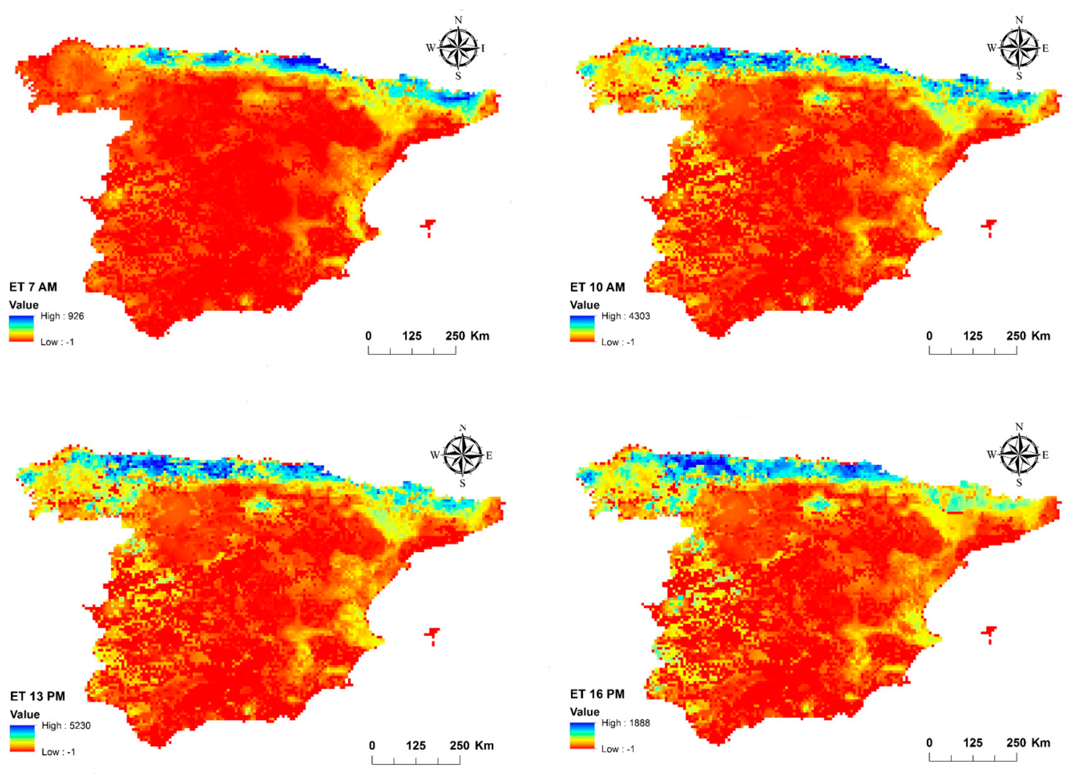
2.2.1. Spinning Enhanced Visible and Infrared Imager (SEVIRI)

Land Surface Analysis Satellite Applications Facility (Landsaf) distribute an operational product of the latent heat (LE) flux, based on observations from the MSG-2 Spinning Enhanced Visible and Infrared Imager (SEVIRI) radiometer, a co-funded space mission between the European Space Agency (ESA) and EUMETSAT Space Agencies. This product has been developed in the framework of the EUMETSAT “Satellite Application Facility” (SAF) on Land Surface Analysis (LSA). The spin-stabilised Meteosat Second Generation (MSG) is a geostationary satellite with a temporal coverage of 15 min. SEVIRI is a multispectral radiometer with a spatial resolution of 3 km at nadir (1 km for the high-resolution visible channel) and 12 spectral channels from the visible to TIR. An example of the ET product is shown in Figure 1.
Briefly, the method developed by LSA-SAF allows estimation of both the instantaneous and daily total ET by the MSG SEVIRI radiometer. It follows a physical approach and can be described as a simplified Soil Vegetation Atmosphere Transfer (SVAT) model modified to accept EO data combined with data from other sources as forcing. The SVAT model employed is essentially a simplified version of the SVAT model TESSEL [27], which computes land surface processes taking both EO and atmospheric parameters as inputs [28]. The algorithm is then adapted to accept real-time data from meteorological satellites as forcing. The main forcing to the model comes from the remote sensing inputs including the daily albedo [29] and half-hourly short-wave [30] and long-wave fluxes [31]. In order to provide ET with a limited amount of missing values, a gap filling procedure is also adopted in the operational algorithm. The daily ET operational product is derived by temporal integration of instantaneous ET operational product values. The integration limits correspond to the first (theoretically at 00:30 UTC) and last (theoretically at 24:00 UTC) existing slots for a given day and the integration step is 30 min.
These two products are provided for the full disk divided in four sub regions (Europe, North Africa, South Africa and South America) and are distributed by the Satellite Application Facility (SAF) on Land Surface Analysis (LSA) [32], from where a series of other operational products are also distributed. A detailed description of the operational algorithm for ET estimation from SEVIRI is available in [33,34]. The MET product contains instantaneous values of ET (in mm h−1) plus an associated quality flag. ET retrievals from this operational product is found to be generally 25% if ET is greater than 0.4 mm h−1 and 0.1 mm h−1 in any other case [18,33,34,35]—see example of validation studies shown in Figure 2 below which comes from a recently published work of one of the co-authors of this manuscript, [35]). Yet, to our knowledge, very few studies have been concerned with establishing the accuracy of the SEVIRI ET instantaneous operational product, particularly at a continental scale [35,36,37].

2.2.2. Geostationary Operational Environmental Satellite (GOES)

A product has been developed to provide operational information on ET for North America based on Geostationary Operational Environmental Satellite (GOES) observations acquired in the visible and infrared parts of the electromagnetic spectrum. This product is generated from the Atmosphere-Land Exchange Inversion model (ALEXI) surface energy balance model [38,39]. This is a the Two-Source Energy Balance (TSEB) approach based on the partitioning of the composite surface radiometric temperature into soil and canopy temperatures, based on the fractional vegetation cover. ALEXI has been specifically designed to minimise the need for ancillary meteorological data while maintaining a physically realistic representation of land-atmosphere exchange over a wide range in vegetation cover conditions. It is also one of few diagnostic land-surface models designed explicitly to exploit the high temporal resolution afforded by geostationary satellites [25]. These advantages make ALEXI capable of routine, long-term mapping of ET and soil moisture stress. A complete ALEXI processing infrastructure has been developed to automatically ingest and pre-process all required input data, to execute the model and to post-process model output which can later be visualised or used in practical applications or research. Because thermal infrared (TIR) retrievals of Land Surface Temperature (LST) are possible only under clear-sky conditions, a gap-filling algorithm has been implemented to estimate ET during cloudy intervals [38,39]. The gap-filled model currently runs daily on a 10-km resolution grid covering the continental US (CONUS) using data from GOES. ALEXI is constrained to operate on spatial scales of 5–10 km, where atmospheric forcing by uniform land-surface behaviour becomes effective. Also, ALEXI ET is retrieved over clear-sky pixels daily and ALEXI drought product is generated over 1 to 6 month compositing periods each day. The generated ET maps are converted to the required formats (GRIB and others) and sent to OSPO for QC monitoring, to ESPC distribution server for distribution and to NCEI/CLASS for archiving.
Outputs of the algorithm include the daily ET product and 2, 4, 8 and 12 week composite of the Evaporative Stress Index (ESI) computed from the ET daily estimates over North America at 8 km. The ALEXI ET estimates—consequently the GOES ET product—have been rigorously evaluated against multi-source in-situ ET observations and various existing drought indices, e.g., US Drought Monitor, Standardised Precipitation Index (SPI), etc. Findings of those studies suggest that the GOES ET algorithm performs well over a range in climatic and vegetation conditions and is capable of producing an average value of 5.5 mm h−1 within an uncertainty of ± 0.5 mm h−1, when operated with an effective surface emissivity of 0.96 ± 0.02 and a heat flux coefficient “B” of 0.20 ± 0.05 [38,39].

2.2.3. MODerate Resolution Imaging Spectroradiometer (MODIS)

Observations from the polar-orbiting MODerate Resolution Imaging Spectroradiometer (MODIS) sensor are used to derive operationally global evapotranspiration (ET)/latent heat flux (LE)/potential ET (PET)/potential LE (PLE) from a product named MOD16-ET. This product has a spatial resolution of 1 km and is available on an 8-day, monthly and yearly basis. The MOD16 ET product is available from the University of Montana’s Numerical Terradynamic Simulation group.
In the product, ET estimation is based on the Penman-Monteith equation, following a technique proposed by Mu et al. [40,41]. Terrestrial ET includes evaporation from wet and moist soil, from rain water intercepted by the canopy before it reaches the ground and the transpiration through stomata on plant leaves and stems. Vertically, ET is the sum of water vapour fluxes from soil evaporation, wet canopy evaporation and plant transpiration at dry canopy surface. Canopy conductance for plant transpiration is calculated by using LAI to scale stomatal conductance up to canopy level. Daily minimum air temperature (Tmin) is used to control dormant and active growing seasons for evergreen biomes. For a given biome type, two threshold values for Tmin and vapour pressure deficit (VPD) are listed in the Biome-Property-Look-Up-Table (BPLUT) to control stomatal conductance [40,41]. MODIS 8-day fraction of Photosynthetically Active Radiation (fPAR) is used as vegetation cover fraction to quantify how much surface net radiation is allocated between soil and vegetation; MODIS 8-day albedo and daily surface downward solar radiation and air temperature from daily meteorological reanalysis data are used to calculate surface net radiation and soil heat flux; daily air temperature, Vapour Pressure Deficit (VPD) and relative humidity data and 8-day MODIS LAI are used to estimate surface stomatal conductance, aerodynamic resistance, wet canopy, soil heat flux and other key environmental variables. MODIS land cover is used to specify the biome type for each pixel and the biome-dependent constant parameters for the algorithm are saved in a Biome-Property-Lookup-Table (BPLUT). Except for minimum daily air temperature and VPD, which are adopted directly from the MODIS global terrestrial gross and net primary production (MODIS GPP/NPP), the BPLUT is tuned largely based on a set of targeted annual ET for each biome derived from MODIS GPP and water use efficiency calculated from eddy flux towers.
A number of studies have been performed evaluating the ET retrieval accuracy by the product at different ecosystem types (e.g., [42]). Overall results from those studies have shown that the algorithm is able to provide ET at a resolution which is useful in a number of applications related to global terrestrial water and energy cycles and environmental changes [42,43]. For example, Jia et al. [44] evaluated spatiotemporal MODIS ET products in the Hai river basin. Inaccuracies, such as over- or under-estimation and no relationship were observed between the flux tower and MOD16 ET estimates in the above publications. Errors or uncertainties are assumed to be caused by misclassification of land cover types from the global MODIS land cover product, scaling from flux tower to landscape and algorithm limitations. Jovanovic et al. [45] evaluated the MOD16 ET product and found that the MOD16 method underestimated ET. Authors also pointed out the need to evaluate global remote sensing products again at long term monitoring sites in South Africa.

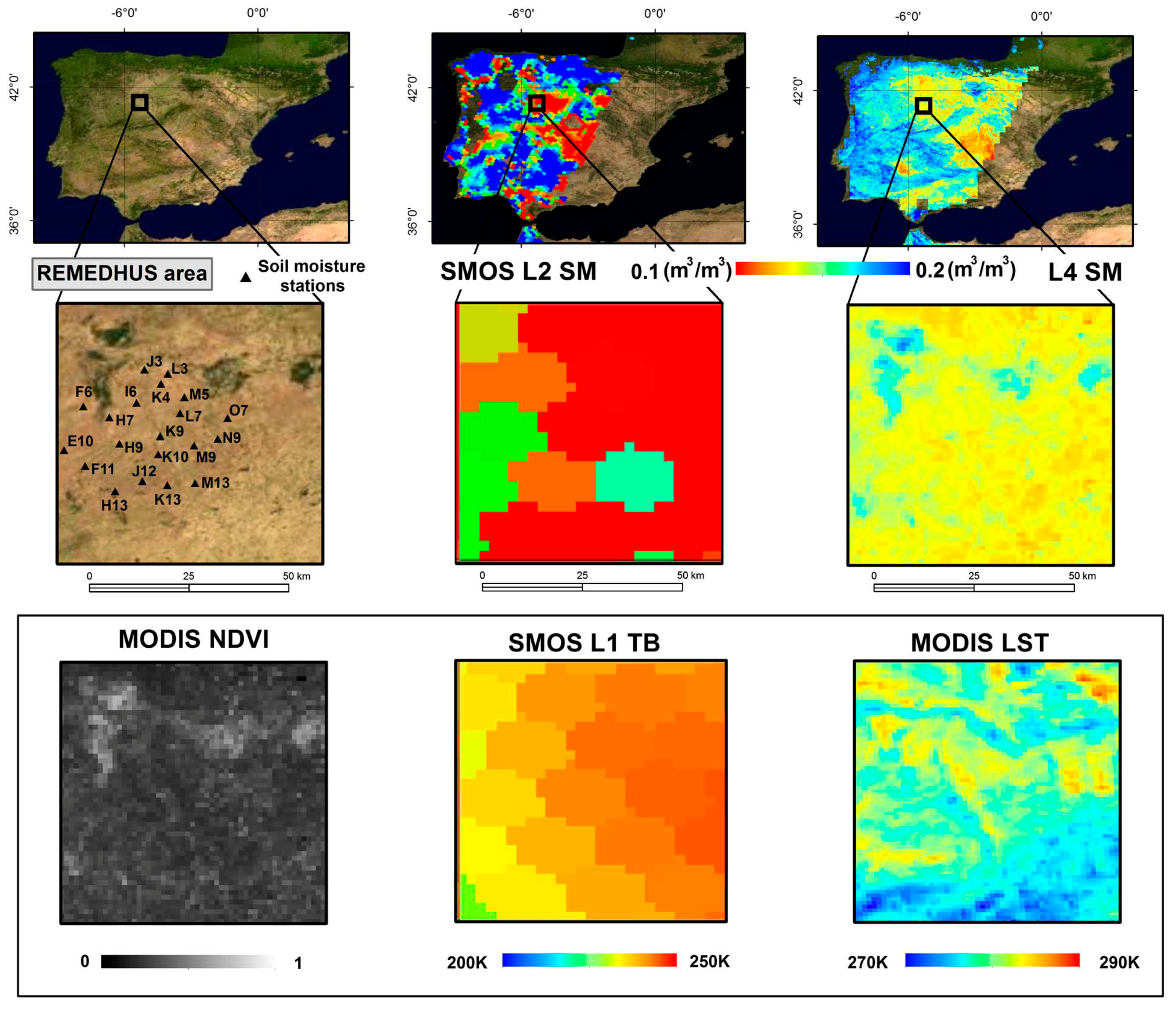
3. Operational Retrievals of SSM from EO

Monitoring of the Earth system from the vantage point of space-borne instruments is nearing its half-century mark. For the most part of this half-century, the instruments have mostly measured in the visible and infrared regions of the spectrum where reflected sunlight and terrestrial thermal emissions are strong and detectable. About mid-way through the half-century, advanced microwave instruments were introduced, adding new perspectives to the study of the Earth’s system. This is especially true for the hydrological cycle, since microwave sensors have allowed for the first time to measure the Earth’s SSM. A variety of methods have been explored for the estimation of soil moisture using EO data from long-heritage optical and thermal infrared sensors and from relatively new microwave sensors [21,46,47]. Among them, theoretical and experimental evidences support the idea that satellite microwave observations are best suited for the retrieval of the Earths’ surface soil moisture on an operational basis. This review will focus on the retrievals of SSM from EO and the operational products available.
The main advantage of microwaves is that they allow the quantitative measurement the Earths’ surface soil moisture as the direct relationship of soil emissivity (or reflectivity) with soil water content and that the atmosphere is almost transparent at these frequencies. In contrast, optical and thermal sensors are only able to provide an indirect estimation [21,47]. Microwave remote sensing encompasses both active and passive forms, depending on the sensor and its mode of operation. While active sensors (scatterometers or Synthetic Aperture Radars-SAR) measure the energy reflected from the land surface after transmitting a pulse of microwave energy, passive sensors (radiometers) measure the self-emission of the land surface. At microwave L-band (1–2 GHz frequency), or “the water frequency channel,” the signal is sensitive to the top 5 cm soil moisture and penetrates through low to moderate layers of vegetation canopy (see recent review by [48]). At higher frequencies (C and X-bands, at 4–8 & 8–12.5 GHz frequency respectively) the signal is sensitive to shallower soil moisture layers and is able to penetrate only through low vegetation densities (C and X-bands) [49]. Dedicated inversion algorithms have been developed to retrieve surface soil moisture tailored to the frequency, measurement concept and characteristics of the different microwave sensors set on space. This intense activity has led to a suite of EO microwave satellite soil moisture data products spanning since 1978 to present. At the time of writing (December 2017), five quasi-operational, i.e., available either in near real time (NRT) or few days after sensing, satellite surface soil moisture products are available from: (1) the Advanced SCATterometer (ASCAT) on-board Metop-A and Metop-B satellites, starting from January 2007 [50]; (2) the Soil Moisture and Ocean Salinity (SMOS), Earth Explorer mission, starting from January 2010 [51]; (3) the Advanced Microwave Scanning Radiometer 2 (AMSR2) on-board the Global Change Observation Mission for Water, GCOM-W starting from July 2012 [42]; (4) the Soil Moisture Active and Passive (SMAP) mission (L-band radiometer) starting from April 2015 [52]; and (5) the disaggregation of SMOS soil moisture using Aqua/Terra MODIS fine-scale information, starting from January 2010. The BEC L4 product is currently providing 1 km soil moisture maps in NRT over the Iberian Peninsula [53,54]. An example of this product is shown in Figure 3 below (adopted from [54]). Recent research studies have shown that its coverage and temporal resolution could be enhanced using MSG SEVIRI data [55] and that finer spatial scales could be reached by using finer optical information [56,57]. An example of operational product from the ESA’s SMOS satellite is shown in Figure 3.
In the near future, higher resolution (<1 km) soil moisture products are expected to become available based on the SAR sensor on-board Sentinel-1 (e.g., [58,59,60,61]) as well as from advanced disaggregation approaches (see review by [62]). Further details of the existing operational SSM products are provided in Table 2.
Soil moisture was recognised by the Global Climate Observing System to be an essential climate variable in 2010. This underscores the potential of the above-mentioned data sets to support climate studies and, in a broader context, the interest in the operational estimation of satellite soil moisture. The ESA Climate Change Initiative (CCI) is one of the first initiatives to merge the different satellite microwave products available into a temporally and spatially consistent data set [57,63]. It is currently providing a multi-decadal soil moisture observational data record that covers partially the last 37 years and is expected to progressively incorporate latest satellite soil moisture products, reaching NRT capabilities by next year [60]. Note that, long-term soil moisture datasets are needed for climate studies and also to undertake robust assessments of the impact of using EO-based soil moisture estimates in Earth Science applications.
Continuity of observational records of surface soil moisture is ensured by the new generations of C-band radiometers (on-board GCOM-W2, GCOM-W3) and C-band scatterometers (on-board MetOp-C, MetOp-SG) and by new mission concepts at L-band, such as the Water Cycle Observation Mission (WCOM) from the Chinese Academy of Sciences, the US and Indian NASA–Indian Space Research Organization Synthetic Aperture Radar (NISAR) and the Argentinian Satélite Argentino de Observación Con Microondas (SAOCOM).
The main benefit of EO soil moisture data is its spatio-temporal coverage and its relatively lower cost for large scale applications as compared to in-situ or airborne acquisitions. The accuracy of the satellite microwave SSM products has been demonstrated in a number of validation studies comparing satellite retrievals with in-situ observations and/or outputs of land surface/hydrological models [61,64,65,66]. Also, the number of applications already using these products has grown in the last years, providing an indirect assessment of their quality. In this regard, a broad and non-exhaustive list of applications that will potentially benefit from the use of satellite soil moisture information includes hydrology [67,68,69], meteorology [70,71] and water resource management [72,73]. The reader is referred to [74] for a comprehensive review of operational applications using satellite soil moisture retrievals. The rest of this section presents sample research studies with focus on the use of soil moisture data on agro-ecology and water management related applications.
Agriculture and Agri-Food Canada (AAFC) has developed a system to integrate multi-sensor soil moisture data (through data intercalibration), therefore allowing the seamless use of AMSR, SMOS and SMAP for agroclimate risk monitoring and reporting [75]. The feasibility of detecting vegetation drought with ASCAT-derived soil moisture was reported in a recent study [76]. Agricultural drought indices based on SMOS soil moisture information have also been developed [77,78]. Using the Famine Early Warning Systems Network (FEWS NET), it was shown that a water requirement satisfaction index could be reformulated to take advantage of a SMAP-like product and provide improved crop yield estimates [79]. At higher spatial resolution (1 km), the experimental BEC L4 SSM product has been shown useful in assessing the impact of dry soil conditions on the decline of different tree species in Catalonia [80], in the determination of the water stress factor used to estimate Gross Primary Production in Mediterranean ecosystems [81] and in predicting the extent and occurrence of wildfires in the Iberian Peninsula [82,83].
Since the amount of water used for irrigation is largely unknown on a global scale, the capability of EO SSM data to provide irrigation assessment can potentially have a tremendous impact in future applications. In this regard, satellite soil moisture estimates were used to account for irrigation—otherwise not possible through model simulations—in a data assimilation framework for forecasting yields of grain crops in Africa [84]. More recently, [85] showed that AMSR-E soil moisture data could be used for discerning the shifting over time in the irrigation practices in north western India and [86] highlighted that the ESA CCI SM product can be used to detect irrigated areas in eastern China by comparing trends in satellite precipitation and soil moisture.

4. Challenges in Operational Estimation of ET/SSM

4.1. Challenges in Operational Estimation of ET

One major challenge in satellite ET estimation is the availability of high resolution imagery at both spatial and temporal scales. Generally, low or moderate resolution imagery is typically available at higher temporal resolution for e.g., MODIS but facing challenges with respect to spatial resolution (~1 km) and available only at 1 week or greater temporal resolution. On the other hand, SEVIRI has high temporal resolution but available at 1–3 km spatial resolution. Data from new remote sensing platforms could prove very useful for downscaling ET estimates to scales that more closely approximate actual agricultural fields. Some researchers attempted multi-sensor fusion to obtain high spatial temporal ET information; yet, presently not available for operational applications. Satellites such as Sentinels 2 and 3 by the European Space Agency (ESA), could provide ET data at high spatial and temporal frequency. Sentinel-2 can provide data in different regions of the electromagnetic spectrum with a revisit time of 5 days at the equator and 2–3 days at mid-latitudes. Therefore, such data can be very useful for vegetation-based ET models, including NDVI and the leaf area index (LAI). In addition, Sentinel-3 is able to provide thermal imagery at 1km resolution with revisit times of approximately 1 day at the equator. Such data can be utilised for developing methodologies to downscale coarser resolution SSM operational products (e.g., from SMOS) to 1 km. However, such approaches are at present at a relatively early stage of development and more research is needed in this direction.
Another major problem is developing algorithms for estimation of ET in heterogeneous landscapes such as in case of crops where agricultural plots are small and need different irrigation practices with respect to crop types. In developing countries like India, Pakistan, Bangladesh etc. are having marginal lands and following either a canal-irrigated system or from groundwater wells using the pumps. This cause a problem in retrieval of ET because of high variation in water level in the agricultural plots, as multiple cropping practices are dominating in these countries to optimize the yield. Most globally-available datasets are at a resolution of 1 km (MOD16) or coarser (PT-JPL, MOD16, GLEAM, SEBS-LF), which is significantly larger than irrigated patches in many areas and hence is a major challenge in obtaining a good quality ET. Even in the United States, where agricultural fields are large, 1 km resolution can be too coarse to resolve individual fields and to map ET differences by crop [87]. The global datasets were designed for ET estimation over large spatial scales, often as input to community land surface models, rather than to assess crop-specific ET. In heterogeneous irrigated landscapes in semi-arid climates, extreme spatial variability in soil moisture and ET means that extremes of low and high ET may occur in a single 1 km pixel, which significantly reduces ET estimates in the 1 km aggregated average. This could result in an underestimation of ET from irrigated cropland if no further disaggregation technique were applied.
Therefore, more complex algorithms that use all visible and NIR bands to model ET in a moving window may be more successful in irrigated landscapes [88]. Techniques such as image sharpening can also be attempted by combining imagery from different satellite platforms, for example by using Landsat to sharpen MODIS imagery, though this has similar problems as the intra-platform sharpening technique in areas where temperature-NDVI relationships are complicated by surface irrigation [39]. Furthermore, from an algorithmic point of view, nearly all available methods in deriving estimates of LE and/or H fluxes have been developed essentially for cloud-free conditions.
In addition, there are significant challenges in evaluating the accuracy of derived ET operational products. This is due to a lack of appropriate “reference” data for different ecosystems worldwide. Evidently, ground instrumentation itself can be limited and our ability to measure ET is dependent on the type of the instrumentation used and the characteristics of the site on which this instrumentation is installed (e.g., an error of 20% is typically expected in the ET measurement by eddy covariance in rugged terrain [14]). The spatial representativeness of the “reference” measurement and how does that compare to the satellite-derived prediction of ET from the operational product is also a question that is hard to answer. To our knowledge, few studies have so far been concerned with establishing the accuracy of such operational products, particularly so at continental or watershed scales [18].

4.2. Challenges in Operational Estimation of SSM

There are number of challenges in the satellite soil moisture estimation for agricultural applications. A key challenge is that the spatial and/or temporal resolutions provided at present by the available operational products do not sufficiently represent the spatio-temporal dynamics/variations and uncertainties of SSM at small scales [21,46]. Many hydrological applications require information on soil moisture at sub-daily temporal resolutions, where this time-dependent data is needed to initialise and update forecast, storm water management, flood or hydrological models. Therefore, there is a requirement for the development of operational SSM information at the requisite spatio-temporal scale for the monitoring of hydrological processes and applications.
Furthermore, another challenge is related to the penetration depth of the EO signal and the depth on which the soil moisture can be retrieved. In visible/IR or even for some wavelengths in the microwave region of the spectrum the penetration depth is very poor. The latter leads to an incomplete picture of the soil moisture profile and is found to be not very suitable for agricultural applications which involves depth wise soil moisture measurements, such as in is the case for of irrigation water demand estimation. The other important problem relevant to this in satellite soil moisture retrieval is the presence of dense vegetation covers, which causes uncertainty in soil moisture retrievals [89]. Therefore, retrieval models able to quantify the vegetation contribution to emissivity are needed for robust soil moisture retrievals, (see recent retrieval approaches for soil moisture and vegetation optical depth at L-band: [90,91]).
A further challenge is related to the acquisition conditions under which SSM can be retrieved. During cloudy conditions soil moisture retrieval from visible/IR satellite produce is not possible. Microwave can provide retrievals under all weather conditions however, they are strongly affected by Radio Frequency Interference (RFI) [92]. In addition, SSM retrieval in areas with high pixel heterogeneity, specially in agro-ecosystems with varying crop type, can cause very significant differences in the behaviour of retrieved SSM [93,94]. This includes regions with the presence of free water within the pixel. Other important factors are the spatial and temporal resolutions of the retrieved soil moisture [9]. As soil moisture is highly variable, sub daily or hourly records are needed for an accurate application of soil moisture especially for irrigation scheduling, this is not possible with present microwave sensors which are on polar orbits and provide measurements during dawn and dusk [95]. Possible solutions to this would be a microwave sensor on a geostationary platform or a retrieval approach combining a polar-orbiting microwave sensor with a VIS/IR geostationary [55].
Lesser accuracy in the soil moisture retrieval due to the variety of reasons mentioned above can cause uncertainty in irrigation scheduling practices. Thus, providing a full characterization of the errors associated with an operational product is another challenge. Remote sensing scientists need to improve the characterization of the errors associated to the soil moisture products and their consistency. To ensure that these operational products can be exploited at full potential, efforts should be directed towards their validation and error characterisation under different climatic and vegetation biomes [18,35]. Such studies should also include the implementation of sensitivity analysis as integrated part of the verification [96].

5. Future Applications with Emphasis in Agriculture

5.1. Water & Agriculture

As already stated at the start of the manuscript, it is estimated that agriculture consumes up to 70% of the world’s fresh water supply [1]. Siebert et al. [97] now estimate that up to 273 M ha of land are irrigated with the majority deployed in south Asia (77 M ha), east Asia (60 M ha) and the United States (29 M ha). The need to increase water use efficiency is seen as a key driver of the sustainable intensification of agriculture [3,98]. This recognizes the key challenge of the need to develop novel technologies that can provide food for an expanding global population, whilst minimising impacts on the environment. Operational estimation of SSM and ET has the potential to underpin water use efficiency across global agricultural applications.
Despite this overwhelming global need, EO operational products approaches in relation to SSM and ET have not been widely adopted by the agricultural community. This is surprising as there is now a global trend towards the development of precision irrigation technology [99]. Ultimately, precision irrigation technology drives water use efficiency by carefully targeting moisture application directly to the needs of individual plants rather than for a whole crop. A key technical barrier to the wide scale adoption of precision irrigation techniques include the availability of operational EO estimates of ET and SSM estimates at high spatio-temporal resolutions.

5.2. EO & Field Irrigation

To date, EO approaches to optimise in field irrigation decision support have focused on optical satellite technology [100,101] via the estimation of key biophysical parameters such as leaf area index (LAI), surface albedo, crop height and in turn key crop coefficient (Kc) required to estimate water requirements. The system reported by Voulo et al. [100] has been deployed in Italy (IRRISAT), Austria (EO4Water) and Australia (IRRIEYE) with a resolution of 20 m. However, all optical EO applications for agricultural irrigation decision support require high temporal frequencies (days not weeks) of image data. There are now increasing numbers of EO platforms that can provide the necessary suite of data and the issue of cloud cover can be overcome using microwave data. This is a critical issue for irrigation support within agriculture. The working capital deployed by farmers to grow crops is extremely high, so in global regions that have significant cloud cover precision irrigation techniques reliant on optical EO techniques to estimate ET and SSM are unlikely to be commercially robust.
Precision irrigation techniques also require high spatial resolutions as SSM is known to vary considerably within fields [102]. These complex spatial variances in soil moisture are driven by multiple factors such as changes in site elevations, soil type, soil density, underlying changes in geology, variances in local crop growth, nutrition etc. For field and precision irrigation, it is critical that on site spatial variance is well understood. However, even ground-based sensors (such as TDR and neutron probes) are of little value in understanding field scale variances in soil moisture. These devices have very small fields of view (cm) and interpolation over field scales would require prohibitive numbers of instruments. However, radar-based EO sensors offer an emerging approach to estimation of soil moisture spatial variability on a field scale (km2). However, robust higher spatial resolutions with EO can only be achieved with calibration against accurate ground truth instruments that measure at within field scale resolutions.
Recent advances in novel ground sensors; in particular cosmic neutron albedo detectors (cosmos sensors) will facilitate necessary ground truth data provision. Cosmos sensors provide direct field scale measurement of soil moisture to within a c. 150 m radius of the sensor [103]. Recently, Evans et al. [104], who described a UK network of ground-based cosmos sensors, showed a reasonable correlation on two different sites (R2 = 0.46, n = 837 days and R2 = 0.59, n = 0.59) between soil moisture retrieved from ASCAT (grid 12.5 km2) and the novel ground sensors. These results were achieved despite a mismatch in the spatial resolutions of the ASCAT and cosmos stations. A further manifestation of cosmos sensor technology has been described by Dong et al. [105]; this group developed a mobile version of the cosmos sensor (“cosmos rover”), which can be deployed on a utility vehicle. The rover was designed to provide rapid estimations of soil moisture across large geographical regions (where there is a lack of ground truth data), or high spatial resolution measurements within a single field. We do foresee that the combination of novel ground truth data (e.g., cosmos sensors) with new high resolution EO active MW platforms (e.g., Sentinel-1) offers significant potential to develop high resolution operational products within field maps of soil moisture. This combination could enable the large-scale and cloud independent, use of EO to underpin in field and precision irrigation decision support.
In addition, irrigation decision support also requires estimates of biophysical parameters in particular LAI and the crop parameter Kc (for a full description of the approach see [49,106]). If cloud denies optical recognition of these parameters then SAR must also be used. The use of radar technologies to estimate LAI is well established (see [49,107,108]). These approaches are not without issues, the radar response can saturate at high LAI [49,109] and the results can be confounded by changes in soil moisture content. However, Bériaux et al. [110] showed that the issues with soil moisture confounding can be partially offset with limited input of independent estimates of ground soil moisture (e.g., TDR or cosmos stations) are included within the LAI estimation framework. It is clear though that in order to be able to use both optical and SAR in remote sensing applications still is required considerable research in order to reach the reliability (e.g., cloud obscuration) and system resilience to support real time precision irrigation application.

6. Conclusions & Future Work Directions

This paper provided a review of the state of the art in the use of EO data to derive operational estimates of ET and SSM. It also discussed emerging applications that can potentially benefit from the integration of ET/SSM operational products. The review suggested there is a significant progress made in recent years in the estimation of ET and SSM parameters from space but further work is required in order to be able to use those products in support of sustainable water management, particularly so at a spatio-temporal scale for the monitoring of hydrological processes and practical applications. Evidently, there are still a number of challenges to be addressed to optimize parameter accuracy and uncertainty and to improve the operational capability of services and practical applications developed using EO data. Despite the breadth of space technology and the promising accuracies reported by different techniques measuring SSM from EO sensors currently in orbit, still primary challenges in using existing operational ET and SSM data remain. Among the key directions on which future work should be directed to address those challenges in both ET and SSM products are included the following:
  • Thanks to advances in instrumentation, space technology and algorithm development, the new generation of satellite sensors are rapidly increasing their capabilities in terms of spatio-temporal resolution and accuracy of retrieved parameters. Also, new technologies such as cubesat and nano-satellites, if well designed, have the potential to provide high spatial-temporal resolution at low costs [71].
  • Although new satellites are planned or already in orbit for estimation of SSM and ET, a better characterisation of the retrievals can only be obtained after development of more robust algorithms. As science is progressing at a good pace, more research devoted to the improvement of present SSM and ET retrieval algorithms is needed to enable a seamless integration of EO-derived information in practical applications. Present challenges to obtain reliable estimates of ET and SSM include the reconstruction of the environmental parameters from the measured signal by using a minimum of auxiliary data. Furthermore, development of new algorithms especially designed for different crop types are needed for an effective monitoring of ET and SSM over agro-ecosystems.
  • In some areas, agricultural fields might be too small for satellite observations for precision irrigation and measurements would have to be taken locally. This is probably especially the case in regions which do not have the financial means for these types of measurements. To address, this issue many researchers are working to produce fine resolution maps for local applications by using the spatial downscaling/disaggregation techniques [55]. Spatial downscaling/upscaling and synergistic approaches can be used to integrate data from different sensors and provide ET/SSM information at the required spatio-temporal resolution, covering the need of agro-hydrological applications. These spatially disaggregated maps are well validated in many regions and could be an alternative to poorly gauged basins/areas. Note, however, that there is generally a trade-off between high spatial resolution and high accuracy and therefore providing the final product with uncertainty bounds is paramount.
  • Data assimilation can be used to constrain models with in-situ and satellite ET/SSM data in decision support systems that enable improved natural resource management, disaster prevention and response and other benefits to society. Also, recent improvements on radar physical modelling and on new SAR and TIR sensing capabilities hold great promise for ET/SSM soil moisture measuring at very high resolution.
  • Benchmarking of the operational products of ET/SSM at different spatial scales and under a range of environmental and climatic conditions against in-situ and modelled estimates and also detailed inter-comparisons between the available satellite products is a very important step that needs to be taken in order to establish the accuracy and uncertainty of the retrieved biophysical parameters, which is a requirement for its use in operational applications.
In this paper, we have provided a comprehensive review on the use of EO estimates of ET and SSM for agricultural applications. The review of literature indicates that more research in the technical literature domain is required on appraisal of ET and SSM over agricultural areas. Also, further studies should focus on estimating and improving ET using the SSM information from the EO dataset, perhaps by using the multi sensor fusion techniques or assimilation of SSM in ET algorithms for e.g., in GLEAM (Global Land Evaporation Amsterdam Model—https://www.gleam.eu/), which has provision for assimilation of SSM to correct random forcing errors.

Acknowledgments

GPP’s contribution has been supported by the FP7-People project ENViSIon-EO (project reference number 334533) and the author gratefully acknowledges the financial support provided by the European Commission. Both GPP and SP have been supported by a UK Research Council award (STFC ST/N006836/1). Thanks also to Salim Lamine for his help with the preparation of Figure 1.

Author Contributions

All authors contributed to the writing of this review manuscript.

Conflicts of Interest

The authors declare no conflict of interest.

References

  1. Shiklomanov, I.A. Comprehensive Assessment of the Freshwater Resources of the World: Assessment of Water Resources and Water Availability in the World; UN: New York, NY, USA, 1996. [Google Scholar]
  2. Wang, K.; Dickinson, R.E. A review of global terrestrial evapotranspiration: Observation, modelling, climatology and climatic variability. Rev. Geophys. 2012, 50. [Google Scholar] [CrossRef]
  3. Anon. The Global Risks Report, 12th ed.; The World Economic Forum: Geneva, Switzerland, 2017. [Google Scholar]
  4. Vorosmarty, C.V.; McIntyre, P.B.; Gessner, M.O.; Dudgeon, D.; Prusevich, A.; Green, P.; Glidden, S.; Bunn, S.E.; Sullivan, C.A.; Reidy Liermann, C.; et al. Global threats to human water security and river biodiversity. Nature 2010, 467, 555–561. [Google Scholar] [CrossRef] [PubMed]
  5. European Community Water Framework. Directive 2000/60/EC of the European parliament and of the council of 23 October 2000 establishing a framework for community action in the field of water policy. Off. J. Eur. Communities 2000, L327, 1–72. [Google Scholar]
  6. IPCC. Climate Change 2013. The Physical Science Basis. Contribution of Working Group I to the Fifth Assessment Report of the Intergovernmental Panel on Climate Change; Stocker, T.F., Qin, D., Plattner, G.-K., Tignor, M., Allen, S.K., Boschung, J., Nauels, A., Xia, Y., Bex, V., Midgley, P.M., Eds.; Cambridge University Press: Cambridge, UK; New York, NY, USA, 2013. [Google Scholar]
  7. Petropoulos, G.P.; North, M.R.; Rentall, D.V.; Ireland, G.I.; McCalmont, J.P. Quantifying the prediction accuracy of a 1-D SVAT model at a range of ecosystems in the USA and Australia: Evidence towards its use as a tool to study Earth’s system interactions. Earth Surf. Dyn. Discuss. 2015, 6, 217–265. [Google Scholar] [CrossRef] [Green Version]
  8. Vereecken, H.; Huisman, J.A.; Pachepsky, Y.; Montzka, C.; van der Kruk, J.; Bogena, H.; Weihermüllera, L.; Herbsta, M.; Martinez, G.; Vanderborght, J. On the spatio-temporal dynamics of soil moisture at the field scale. J. Hydrol. 2013, 516, 76–96. [Google Scholar] [CrossRef]
  9. Ireland, G.; Petropoulos, G.P.; Carlson, T.N.; Purdy, S. Addressing the ability of a land biosphere model to predict key biophysical vegetation characterisation parameters with global sensitivity analysis. Environ. Model. Softw. 2015, 65, 94–107. [Google Scholar] [CrossRef]
  10. Ramoelo, A.; Majozi, N.; Mathieu, R.; Jovanovic, N.; Nickless, A.; Dzikiti, S. Validation of global evapotranspiration product (MOD16) using flux tower data in the African savanna, South Africa. Remote Sens. 2014, 6, 7406–7423. [Google Scholar] [CrossRef]
  11. Crow, W.T.; Berg, A.; Cosh, M.H.; Loew, A.; Mohanty, B.P.; Panciera, R.; de Rosnay, P.; Ryu, D.; Walker, J.P. Upscaling sparse ground-based soil moisture observations for the validation of coarse-resolution satellite soil moisture products. Rev. Geophys. 2012, 50. [Google Scholar] [CrossRef]
  12. Petropoulos, G.P.; McCalmont, J.P. An operational in-situ soil moisture and soil temperature monitoring network for west Wales, UK: The WSMN network. Sensors 2017, 17, 1481. [Google Scholar] [CrossRef] [PubMed]
  13. Srivastava, P.K.; Han, D.; Islam, T.; Petropoulos, G.P.; Gupta, M.; Dai, Q. Seasonal evaluation of evapotranspiration fluxes from MODIS satellite and mesoscale model downscaled global reanalysis datasets. Theor. Appl. Climatol. 2016, 124, 461–473. [Google Scholar] [CrossRef]
  14. Petropoulos, G.P.; Carlson, T.N.; Griffiths, H.M. Turbulent fluxes of heat and moisture at the earth’s land surface: Importance, controlling parameters and conventional measurement. In Remote Sensing of Energy Fluxes and Soil Moisture Content; Petropoulos, G.P., Ed.; Taylor and Francis: Oxford, UK, 2013; Chapter 1; pp. 3–28. [Google Scholar]
  15. Petropoulos, G.P.; Griffiths, H.; Dorigo, W.; Xaver, A.; Gruber, A. Surface soil moisture estimation: Significance, controls and conventional measurement techniques. In Remote Sensing of Energy Fluxes and Soil Moisture Content; Petropoulos, G.P., Ed.; Taylor and Francis: Oxford, UK, 2013; Chapter 2; pp. 29–48. [Google Scholar]
  16. Yebra, M.; Van Dijk, A.; Leuning, R.; Huete, A.; Guerschman, J.P. Evaluation of optical remote sensing to estimate actual evapotranspiration and canopy conductance. Remote Sens. Environ. 2013, 129, 250–261. [Google Scholar] [CrossRef]
  17. Tian, F.; Qiu, G.; Lü, Y.; Yang, Y.; Xiong, Y. Use of high-resolution thermal infrared remote sensing and “three-temperature model” for transpiration monitoring in arid inland river catchment. J. Hydrol. 2014, 515, 307–315. [Google Scholar] [CrossRef]
  18. Petropoulos, G.P.; Ireland, G.; Srivastava, P.K. Performance assessment of the SEVIRI evapotranspiration operational product: Results over diverse Mediterranean ecosystems. IEEE Sens. J. 2015. [Google Scholar] [CrossRef]
  19. Singh, S.K.; Srivastava, P.K.; Szabo, S.; Petropoulos, G.P.; Gupta, M.; Islam, T. Landscape transform and spatial metrics for mapping spatiotemporal land cover dynamics using Earth Observation datasets. Geocarto Int. 2016, 32, 113–127. [Google Scholar]
  20. Biggs, T.; Petropoulos, G.P.; Velpuri, N.M.; Marshall, M.; Glenn, E.P.; Nagler, P.; Messina, A. Remote sensing of actual evapotranspiration from croplands. In Remote Sensing of Water Resources, Disasters and Urban Studies; Thenkabail, P.S., Ed.; Taylor and Francis: Oxford, UK, 2015; Chapter 3; pp. 59–100. [Google Scholar]
  21. Petropoulos, G.P.; Ireland, G.; Barrett, B. Surface soil moisture retrievals from remote sensing: Current status, products & future trends. Phys. Chem. Earth 2015. [Google Scholar] [CrossRef]
  22. Li, Z.-L.; Tang, R.; Wan, Z.; Bi, Y.; Zou, C.; Tang, B.; Yan, G.; Zhang, X. A review of current methodologies for regional evapotranspiration estimation from remotely sensed data. Sensors 2009, 9, 3801–3852. [Google Scholar] [CrossRef] [PubMed]
  23. Petropoulos, G.; Carlson, T.N.; Wooster, M.J.; Islam, S. A review of Ts/VI remote sensing based methods for the retrieval of land surface fluxes and soil surface moisture content. Prog. Phys. Geogr. 2009, 33, 1–27. [Google Scholar]
  24. Price, J.C. The potential of remotely sensed thermal infrared data to infer surface soil moisture and evaporation. Water Resour. Res. 1980, 16, 787–795. [Google Scholar] [CrossRef]
  25. Anderson, M.C.; Kustas, W.P.; Norman, J.M.; Hain, C.R.; Mecikalski, J.R.; Schultz, L.; Gonzalez-Dugo, M.P.; Mamalleri, C.; d’Urso, G.; Pimsten, A.; et al. Mapping daily evapotranspiration at field to continental scales using geostationary and polar orbiting satellite imagery. Hydrol. Earth Syst. Sci. 2011, 15, 223–239. [Google Scholar] [CrossRef] [Green Version]
  26. Liou, Y.-A.; Kar, S.K. Evapotranspiration estimation with remote sensing and various surface energy balance algorithms—A Review. Energies 2014, 7, 2821–2849. [Google Scholar] [CrossRef]
  27. Viterbo, P.; Beljaars, A.C.M. An improved land surface parameterization scheme in the ECMWF model and its validation. J. Clim. 1995, 8, 2716–2748. [Google Scholar] [CrossRef]
  28. Gellens-Meulenberghs, F.; Arboleda, A.; Ghilain, N. Towards a Continuous Monitoring of Evapotranspiration Based on MSG Data. Available online: https://pdfs.semanticscholar.org/f4e9/2772d36a18bca3d963518c1c40e3ee978de5.pdf?_ga=2.181035749.396598863.1515554899-436484136.1515554899 (accessed on 10 January 2018).
  29. Geiger, B.; Carrer, D.; Franchisteguy, L.; Roujean, J.-L.; Meurey, C. Land surface albedo derived on a daily basis from meteosat second generation observations. IEEE Trans. Geosci. Remote Sens. 2008, 46, 3841–3856. [Google Scholar] [CrossRef]
  30. Geiger, B.; Meurey, C.; Lajas, D.; Franchisteguy, L.; Carrer, D.; Roujean, J.-L. Near real time provision of downwelling shortwave radiation estimates derived from satellite observations. Meteorol. Appl. 2008, 15, 411–420. [Google Scholar] [CrossRef]
  31. Ineichen, P.; Barroso, C.S.; Geiger, B.; Hollmann, R.; Marsouin, A.; Mueller, R. Satellite application facilities irradiance products: Hourly time step comparison and validation over Europe. Int. J. Remote Sens. 2009, 30. [Google Scholar] [CrossRef]
  32. Trigo, I.F.; DaCamara, C.C.; Viterbo, P.; Roujean, J.-L.; Olesen, F.; Barroso, C.; Camacho-de Coca, F.; Carrer, D.; Freitas, S.C.; GarcÃa-Haro, J.; et al. The satellite application facility on land surface analysis. Int. J. Remote Sens. 2011, 32, 2725–2744. [Google Scholar] [CrossRef]
  33. Ghilain, N.; De Roo, F.; Gellens-Meulenberghs, F. Evapotranspiration monitoring with meteosat second generation satellites: Improvement opportunities from moderate spatial resolution satellites for vegetation. Int. J. Remote Sens. 2014. [Google Scholar] [CrossRef]
  34. MSG-2 Evapotranspiration Product Algorithm Theoretical Basis Document 2008. Available online: http://landsaf.meteo.pt/algorithms.jsp;jsessionid=43A1CD5F12EA9E53C2106C9B943D1642?seltab=6&starttab=6#adescription (accessed on 7 December 2017).
  35. Petropoulos, G.P.; Ireland, G.; Lamine, S.; Ghilain, N.; Anagnostopoulos, V.; North, M.R.; Srivastava, P.K.; Georgopoulou, H. Evapotranspiration estimates from SEVIRI to support sustainable water management. Int. J. Appl. Earth Obs. Geoinf. 2016, 49, 175–187. [Google Scholar] [CrossRef]
  36. Ghilain, N.; Arboleda, A.; Gellens-Meulenberghs, F. Evapotranspiration modelling at large scale using near-real time MSG SEVIRI derived data. Hydrol. Earth Syst. Sci. 2011, 15, 771–786. [Google Scholar] [CrossRef]
  37. Sepulcre-Cantoet, G.; Vogt, J.; Arboleda, A.; Antofie, T. Assessment of the EUMETSAT LSA-SAF evapotranspiration product for drought monitoring in Europe. Int. J. Appl. Earth Obs. Geoinf. 2014, 30, 190–202. [Google Scholar] [CrossRef]
  38. Anderson, M.C.; Norman, J.M.; Diak, G.R.; Kustas, W.P.; Mecikalski, J.R. A two-source time-integrated model for estimating surface fluxes using thermal infrared remote sensing. Remote Sens. Environ. 1997, 60, 195–216. [Google Scholar] [CrossRef]
  39. Anderson, M.C.; Norman, J.M.; Mecikalski, J.R.; Otkin, J.P.; Kustas, W.P. A climatological study of evapotranspiration and moisture stress across the continental U.S. based on thermal remote sensing: I. Model formulation. J. Geophys. Res. 2007, 112, D10. [Google Scholar]
  40. Mu, Q.; Heinsch, F.A.; Zhao, M.; Running, S.W. Development of a global evapotranspiration algorithm based on MODIS and global meteorology data. Remote Sens. Environ. 2007, 111, 519–536. [Google Scholar] [CrossRef]
  41. Mu, Q.; Zhao, M.; Running, S.W. Improvements to a MODIS global terrestrial evapotranspiration algorithm. Remote Sens. Environ. 2011, 115, 1781–1800. [Google Scholar] [CrossRef]
  42. Kim, S.; Liu, Y.Y.; Johnson, F.M.; Parinussa, R.M.; Sharma, A. A global comparison of alternate AMSR2 soil moisture products: Why do they differ? Remote Sens. Environ. 2015, 161, 43–62. [Google Scholar] [CrossRef]
  43. Mu, Q.; Jones, L.A.; Kimball, J.S.; McDonald, K.C.; Running, S.W. Satellite assessment of land surface evapotranspiration for the pan-Arctic domain. Water Resour. Res. 2009, 45. [Google Scholar] [CrossRef]
  44. Jia, Z.; Liu, S.; Xu, Z.; Chen, Y.; Zhu, M. Validation of remote sensed evapotranspiration over the Hai River Basin, China. J. Geophys. Res. Atmos. 2012. [Google Scholar] [CrossRef]
  45. Jovanovic, N.; Masiyandima, M.; Naiken, V.; Dzikiti, S.; Gush, M. Remote Sensing Applications in Water Resources Management—Desktop Validation and Draft Paper; CSIR Report No. CSIR/NRE/ECOS/IR/2011/0097/A; CSIR: Pretoria, South Africa, 2012. [Google Scholar]
  46. Ochsner, T.E.; Cosh, M.H.; Cuenca, R.H.; Dorigo, W.A.; Draper, C.S.; Hagimoto, Y.; Kerr, Y.H.; Njoku, E.G.; Small, E.E.; Zreda, M. State of the art in large-scale soil moisture monitoring. Soil Sci. Soc. Am. J. 2013, 77, 1888–1919. [Google Scholar] [CrossRef] [Green Version]
  47. Fang, B.; Lakshmi, V. Soil moisture at watershed scale: Remote sensing techniques. J. Hydrol. 2014, 516, 258–272. [Google Scholar] [CrossRef]
  48. Wigneron, J.-P.; Jackson, T.J.; O’Neill, P.; De Lannoy, P.; de Rosnay, J.P.; Walker, P.; Ferrazzoli, V.; Mironov, S.; Bircher, J.P.; Grant, M.; et al. Modelling the passive microwave signature from land surfaces: A review of recent results and application to the L-band SMOS and SMAP soil moisture retrieval algorithms. Remote Sens. Environ. 2017, 192, 238–262. [Google Scholar] [CrossRef]
  49. Ulaby, F.T.; Allen, C.T.; Eger, G.; Kanemasu, E. Relating the microwave backscattering coefficient to leaf area index. Remote Sens. Environ. 1984, 14, 113–133. [Google Scholar] [CrossRef]
  50. Wagner, W.; Hahn, S.; Kidd, R.; Melzer, T.; Bartalis, Z.; Hasenauer, S.; Figa-Saldaña, J.; de Rosnay, P.; Jann, A.; Schneider, S. The ASCAT soil moisture product: A review of its specifications, validation results and emerging applications. Meteorol. Z. 2013, 22, 5–33. [Google Scholar] [CrossRef]
  51. Kerr, Y.H.; Waldteufel, P.; Richaume, P.; Wigneron, J.-P.; Ferrazzoli, P.; Mahmoodi, A.; Al Bitar, A.; Cabot, F.; Gruhier, C.; Juglea, S.E.; et al. The SMOS soil moisture retrieval algorithm. IEEE Trans. Geosci. Remote Sens. 2012, 50, 1384–1403. [Google Scholar] [CrossRef]
  52. Chan, S.K.; Bindlish, R.; O’Neill, P.E. Assessment of the SMAP passive soil moisture product. IEEE Trans. Geosci. Remote Sens. 2016, 54, 4994–5007. [Google Scholar] [CrossRef]
  53. Piles, M.; Sánchez, N.; Vall-llossera, M.; Camps, A.; Martínez-Fernández, J.; Martínez, J.; González-Gambau, V. A downscaling approach for SMOS land observations: Evaluation of high resolution soil moisture maps over the Iberian Peninsula. IEEE J. Sel. Top. Appl. Earth Obs. Remote Sens. 2014, 7, 3845–3857. [Google Scholar] [CrossRef]
  54. Piles, M.; Vall-Llossera, M.; Camps, A.; Sanchez, N.; Martinez-Fernandez, J.; Martinez, J.; Gonzalez-Gambau, V.; Riera, R. On the synergy of SMOS and Terra/Aqua MODIS: High resolution soil moisture maps in near real-time. In Proceedings of the International Geoscience and Remote Sensing Symposium (IGARSS), Melbourne, Australia, 21–26 July 2013; pp. 3423–3426. [Google Scholar]
  55. Piles, M.; Petropoulos, G.; Sánchez, N.; González-Zamora, A.; Ireland, G. Towards improved spatio-temporal resolution soil moisture retrievals from the synergy of SMOS and MSG SEVIRI spaceborne observations. Remote Sens. Environ. 2016, 180, 403–417. [Google Scholar] [CrossRef]
  56. Sánchez-Ruiz, S.; Piles, M.; Sánchez, N.; Martínez-Fernández, J.; Vall-llossera, M.; Camps, A. Combining SMOS with visible and near/shortwave/thermal infrared satellite data for high resolution soil moisture estimates. J. Hydrol. 2014, 49, 3156–3166. [Google Scholar] [CrossRef]
  57. Dorigo, W.; Wagner, W.; Albergel, C.; Albrecht, F.; Balsamo, G.; Brocca, L.; Chung, D.; Ertl, M.; Forkel, M.; Gruber, A.; et al. ESA CCI Soil Moisture for improved Earth system understanding: State-of-the art and future directions. Remote Sens. Environ. 2017, 203, 185–215. [Google Scholar] [CrossRef]
  58. Wagner, W.; Sabel, D.; Doubkova, M.; Bartsch, A.; Pathe, C. The potential of Sentinel-1 for monitoring soil moisture with a high spatial resolution at global scale. In Proceedings of the Earth Observation and Water Cycle Science Symposium, Frascati, Italy, 18–20 November 2009. [Google Scholar]
  59. Paloscia, S.; Pettinato, S.; Santi, E.; Notarnicola, C.; Pasolli, L.; Reppucci, A. Soil moisture mapping using Sentinel-1 images: Algorithm and preliminary validation. Remote Sens. Environ. 2013, 134, 234–248. [Google Scholar] [CrossRef]
  60. Enenkel, M.; Reimer, C.; Dorigo, W.; Wagner, W.; Pfeil, I.; Parinussa, R.; De Jeu, R. Combining satellite observations to develop a global soil moisture product for near-real-time applications. Hydrol. Earth Syst. Sci. 2016, 20, 4191–4208. [Google Scholar] [CrossRef]
  61. Brocca, L.; Hasenauer, S.; Lacava, T.; Melone, F.; Moramarco, T.; Wagner, W.; Dorigo, W.; Matgen, P.; Martínez-Fernández, L.; Llorens, P.; et al. Soil moisture estimation through ASCAT and AMSR-E sensors: An intercomparison and validation study across Europe. Remote Sens. Environ. 2011, 115, 3390–3408. [Google Scholar] [CrossRef]
  62. Peng, J.; Loew, A.; Merlin, O.; Verhoest, N.E.C. A Review of Spatial Downscaling of Satellite 798 Remotely Sensed Soil Moisture. Available online: http://smw.geo.tuwien.ac.at/fileadmin/editors/SMworkshop/presentations/Day3/Session4/05_Peng.pdf (accessed on 11 January 2018).
  63. Dorigo, W.A.; Gruber, A.; De Jeu, R.A.M.; Wagner, W.; Stacke, T.; Loew, A.; Albergel, C.; Brocca, L.; Chung, D.; Parinussa, R.M.; et al. Evaluation of the ESA CCI soil moisture product using ground-based observations. Remote Sens. Environ. 2015, 162, 380–395. [Google Scholar] [CrossRef]
  64. Albergel, C.; Dorigo, W.; Balsamo, G.; Muñoz-Sabater, J.; de Rosnay, P.; Isaksen, L.; Brocca, L.; de Jeu, R.; Wagner, W. Monitoring multi-decadal satellite earth observation of soil moisture products through land surface reanalyses. Remote Sens. Environ. 2013, 138, 77–89. [Google Scholar] [CrossRef]
  65. González-Zamora, A.; Sánchez, N.; Martínez-Fernández, J.; Gumuzzio, A.; Piles, M.; Olmedo, E. Long-term SMOS soil moisture products: A comprehensive evaluation across scales and methods in the Duero Basin (Spain). Phys. Chem. Earth Parts A/B/C 2015, 83–84, 123–136. [Google Scholar]
  66. Polcher, J.; Piles, M.; Gelati, E.; Barella-Ortiz, A.; Tello, M. Comparing surface soil moisture from the SMOS mission and the ORCHIDEE land-surface model over the Iberian Peninsula. Remote Sens. Environ. 2016, 174, 69–81. [Google Scholar] [CrossRef]
  67. Alvarez-Garreton, C.; Ryu, D.; Western, A.W.; Su, C.H.; Crow, W.T.; Robertson, D.E.; Leahy, C. Improving operational flood ensemble prediction by the assimilation of satellite soil moisture: Comparison between lumped and semi-distributed schemes. Hydrol. Earth Syst. Sci. 2015, 19, 1659–1676. [Google Scholar] [CrossRef]
  68. McCabe, M.F.; Rodell, M.; Alsdorf, D.E.; Miralles, D.G.; Uijlenhoet, R.; Wagner, W.; Lucieer, A.; Houborg, R.; Verhoest, N.E.C.; Franz, T.E.; et al. The future of earth observation in hydrology. Hydrol. Earth Syst. Sci. 2017, 21, 3879–3914. [Google Scholar] [CrossRef]
  69. Brocca, L.; Ciabatta, L.; Massari, C.; Camici, S.; Tarpanelli, A. Soil moisture for hydrological applications: Open questions and new opportunities. Water 2017, 9, 140. [Google Scholar] [CrossRef]
  70. De Rosnay, P.; Drusch, M.; Vasiljevic, D.; Balsamo, G.; Albergel, C.; Isaksen, L.A. Simplified extended Kalman filter for the global operational soil moisture analysis at ECMWF. Q. J. R. Meteorol. Soc. 2013, 139, 1199–1213. [Google Scholar] [CrossRef]
  71. Muñoz-Sabater, J. Incorporation of passive microwave brightness temperatures in the ECMWF soil moisture analysis. Remote Sens. 2015, 7, 5758–5784. [Google Scholar] [CrossRef]
  72. Engman, E.T. Applications of microwave remote sensing of soil moisture for water resources and agriculture. Remote Sens. Environ. 1991, 35, 213–226. [Google Scholar] [CrossRef]
  73. Bastiaanssen, W.G.M.; Noordman, E.J.M.; Pelgrum, H.; Davids, G.; Thoreson, B.P.; Allen, R.G. SEBAL model with remotely sensed data to improve water-resources management under actual field conditions. ASCE J. Irrig. Drain. Eng. 2005, 131, 85–93. [Google Scholar] [CrossRef]
  74. Muñoz-Sabater, J.; Al Bitar, A.; Brocca, L. Soil moisture retrievals based on active and passive microwave data: State-of-the-art and operational applications. In Satellite Soil Moisture Retrievals: Techniques and Applications; Petropoulos, G.P., Srivastava, P., Kerr, Y., Eds.; Elsevier: Amsterdam, The Netherlands, 2016; Volume 18, pp. 351–378. [Google Scholar]
  75. Champagne, C.; Davidson, A.; Cherneski, P.; L’Heureux, J.; Hadwen, T. Monitoring agricultural risk in Canada using l-band passive microwave soil moisture from SMOS. J. Hydrometeorol. 2015, 16, 5–18. [Google Scholar] [CrossRef]
  76. Schroeder, R.; McDonald, K.C.; Azarderakhsh, M.; Zimmermann, R. ASCAT MetOp-A diurnal backscatter observations of recent vegetation drought patterns over the contiguous US: An assessment of spatial extent and relationship with precipitation and crop yield. Remote Sens. Environ. 2016, 177, 153–159. [Google Scholar] [CrossRef]
  77. Sánchez, N.; González-Zamora, A.; Piles, M.; Martínez-Fernández, J. A new Soil Moisture Agricultural Drought Index (SMADI) integrating MODIS and SMOS products: A case of study over the Iberian Peninsula. Remote Sens. 2016, 8, 287. [Google Scholar] [CrossRef]
  78. Martínez-Fernández, J.; González-Zamora, A.; Sánchez, N.; Gumuzzio, A.; Herrero-Jiménez, C.M. Satellite soil moisture for agricultural drought monitoring: Assessment of the SMOS derived Soil Water Deficit Index. Remote Sens. Environ. 2016, 177, 277–286. [Google Scholar] [CrossRef]
  79. McNally, A.; Husak, G.J.; Brown, M.; Carroll, M.; Funk, C.; Yatheendradas, S.; Arsenault, K.; Peters-Lidard, C.; Verdin, J.P. Calculating crop water requirement satisfaction in the West Africa Sahel with remotely sensed soil moisture. J. Hydrometeorol. 2015, 16, 295–305. [Google Scholar] [CrossRef]
  80. Chaparro, D.; Vayreda, J.; Vall-llossera, M.; Banqué, M.; Piles, M.; Camps, A.; Martínez-Vilalta, J. The role of climatic anomalies and soil moisture in the decline of drought-prone forests. IEEE J. Sel. Top. Appl. Earth Obs. Remote Sens. 2016, PP, 1–12. [Google Scholar] [CrossRef]
  81. Sanchez-Ruiz, S.; Moreno, A.; Piles, M.; Maselli, F.; Carrara, A.; Running, S.; Gilabert, M.A. Quantifying water stress effect on daily light use efficiency in Mediterranean ecosystems using satellite data. Int. J. Digit. Earth 2016. [Google Scholar] [CrossRef]
  82. Chaparro, D.; Piles, M.; Vall-llossera, M.; Camps, A. Surface moisture and temperature trends anticipate drought conditions linked to wildfire activity in the Iberian Peninsula. Eur. J. Remote Sens. 2016, 49, 955–971. [Google Scholar] [CrossRef]
  83. Chaparro, D.; Vall-llossera, M.; Piles, M.; Camps, A.; Rüdiger, C.; Riera-Tatché, R. Predicting the extent of wildfires using remotely sensed soil moisture and temperature trends. IEEE J. Sel. Top. Appl. Earth Obs. Remote Sens. 2016, 9, 2818–2829. [Google Scholar] [CrossRef]
  84. Ines, A.V.M.; Das, N.N.; Hansen, J.W.; Njoku, E.G. Assimilation of remotely sensed soil moisture and vegetation with a crop simulation model for maize yield prediction. Remote Sens. Environ. 2013, 138, 149–164. [Google Scholar] [CrossRef]
  85. Singh, D.; Gupta, P.K.; Pradhan, R.; Dubey, A.K.; Singh, R.P. Discerning shifting irrigation practices from passive microwave radiometry over Punjab and Haryana. J. Water Clim. Chang. 2016. [Google Scholar] [CrossRef]
  86. Qiu, J.; Gao, Q.; Wang, S.; Su, Z. Comparison of temporal trends from multiple soil moisture data sets and precipitation: The implication of irrigation on regional soil moisture trend. Int. J. Appl. Earth Obs. Geoinform. 2016, 48, 17–27. [Google Scholar] [CrossRef]
  87. Kustas, W.P.; Li, F.; Jackson, T.J.; Prueger, J.H.; MacPherson, J.I.; Wolde, M. Effects of remote sensing pixel resolution on modelled energy flux variability of croplands in Iowa. Remote Sens. Environ. 2004, 92, 535–547. [Google Scholar] [CrossRef]
  88. Gao, F.; Kustas, W.P.; Anderson, M.C. A data mining approach for sharpening thermal satellite imagery over land. Remote Sens. 2012, 4, 3287–3319. [Google Scholar] [CrossRef]
  89. Srivastava, P.K.; Han, D.; Ramirez, M.A.; O’Neill, P.; Islam, T.; Gupta, M. Assessment of SMOS soil moisture retrieval parameters using tau-omega algorithms for soil moisture deficit estimation. J. Hydrol. 2014, 519, 574–587. [Google Scholar] [CrossRef]
  90. Konings, A.G.; Piles, M.; Rotzer, K.; McColl, K.A.; Chan, S.K.; Entekhabi, D. Vegetation optical depth and scattering albedo retrieval using time series of dual polarized L-band radiometer observations. Remote Sens. Environ. 2016, 172, 178–189. [Google Scholar] [CrossRef]
  91. Fernandez-Moran, R.; Al-Yaari, A.; Mialon, A.; Mahmoodi, A.; Al Bitar, A.; De Lannoy, G.; Rodriguez-Fernandez, N.; Lopez-Baeza, E.; Kerr, Y.; Wigneron, J.-P. SMOS-IC: An Alternative SMOS soil moisture and vegetation optical depth product. Remote Sens. 2017, 9, 457. [Google Scholar] [CrossRef]
  92. Islam, T.; Srivastava, P.K.; Dai, Q.; Gupta, M.; Zhuo, L. An introduction to factor analysis for radio frequency interference detection on satellite observations. Meteorol. Appl. 2015, 22, 436–443. [Google Scholar] [CrossRef]
  93. Kerr, Y.H.; Wigneron, J.P.; Al Bitar, A.; Mialon, A.; Srivastava, P.K. Soil Moisture from Space: Techniques and Limitations, Satellite Soil Moisture Retrieval; Elsevier: Amsterdam, The Netherlands, 2016; Chapter 1; pp. 3–27. [Google Scholar]
  94. Gruber, A.; Su, C.; Crow, W.; Zwieback, S.; Dorigo, W.; Wagner, W. Estimating error cross-correlations in soil moisture data sets using extended collocation analysis. J. Geophys. Res. Atmos. 2016, 121, 1208–1219. [Google Scholar] [CrossRef]
  95. Srivastava, P.K. Satellite soil moisture: Review of theory and applications in water resources. Water Resour. Manag. 2017, 31, 3161–3176. [Google Scholar] [CrossRef]
  96. Lee, L.; Srivastava, P.K.; Petropoulos, G.P. Overview of sensitivity analysis methods in earth observation modelling. In Sensitivity Analysis in Earth Observation; Petropoulos, G.P., Srivastava, P.K., Eds.; Elsevier: Amsterdam, The Netherlands, 2016; Chapter 1; pp. 4–18. [Google Scholar]
  97. Siebert, S.; Döll, P.; Hoogeveen, J.; Faures, J.M.; Frenken, K.; Feick, S. Development and validation of the global map of irrigation areas. Hydrol. Earth Syst. Sci. Discuss. 2005, 2, 1299–1327. [Google Scholar] [CrossRef]
  98. Baulcombe, D.; Crute, I.; Davies, B.; Dunwell, J.; Gale, M.; Jones, J.; Pretty, J.; Sutherland, W.; Toulmin, C. Reaping the Benefits: Science and the Sustainable Intensification of Global Agriculture; The Royal Society: London, UK, 2009. [Google Scholar]
  99. Adeyemi, O.; Grove, I.; Peets, S.; Norton, T. Advanced monitoring and management systems for improving sustainability in precision irrigation. Sustainability 2017, 9, 353. [Google Scholar] [CrossRef]
  100. Vuolo, F.; D’Urso, G.; De Michele, C.; Bianchi, B.; Cutting, M. Satellite-based irrigation advisory services: A common tool for different experiences from Europe to Australia. Agric. Water Manag. 2015, 147, 82–95. [Google Scholar] [CrossRef]
  101. Calera, A.; Campos, I.; Osann, A.; D’Urso, G.; Menenti, M. Remote sensing for crop water management: From ET modelling to services for the end users. Sensors 2017, 17, 1104. [Google Scholar] [CrossRef] [PubMed]
  102. Hupet, F.; Vanclooster, M. Intraseasonal dynamics of soil moisture variability within a small agricultural maize cropped field. J. Hydrol. 2002, 261, 86–101. [Google Scholar] [CrossRef]
  103. Zreda, M.; Desilets, D.; Ferré, T.P.A.; Scott, R.L. Measuring soil moisture content non-invasively at intermediate spatial scale using cosmic-ray neutrons. Geophys. Res. Lett. 2008, 35. [Google Scholar] [CrossRef]
  104. Evans, J.G.; Ward, H.C.; Blake, J.R.; Hewitt, E.J.; Morrison, R.; Fry, M.; Ball, L.A.; Doughty, L.C.; Libre, J.W.; Hitt, O.E.; et al. Soil water content in southern England derived from a cosmic-ray soil moisture observing system–COSMOS-UK. Hydrol. Process. 2016, 30, 4987–4999. [Google Scholar] [CrossRef] [Green Version]
  105. Dong, J.; Ochsner, T.E.; Zreda, M.; Cosh, M.H.; Zou, C.B. Calibration and validation of the COSMOS rover for surface soil moisture measurement. Vadose Zone J. 2014. [Google Scholar] [CrossRef]
  106. Allen, R.G.; Pereira, L.S.; Raes, D.; Smith, M. FAO Irrigation and Drainage Paper No. 56; Food and Agriculture Organization of the United Nations: Rome, Italy, 1998; Volume 56, pp. 97–156. [Google Scholar]
  107. Steele-Dunne, S.C.; McNairn, H.; Monsivais-Huertero, A.; Judge, J.; Liu, P.W.; Papathanassiou, K. Radar remote sensing of agricultural canopies: A review. IEEE J. Sel. Top. Appl. Earth Obs. Remote Sens. 2017, 10, 2249–2273. [Google Scholar] [CrossRef]
  108. Tao, L.; Li, J.; Jiang, J.; Chen, X.; Cai, Q. A modified vegetation backscattering model for leaf area index retrieval from SAR time series. Int. J. Remote Sens. 2016, 37, 5884–5901. [Google Scholar] [CrossRef]
  109. Jiao, X.; McNairn, H.; Shang, J.; Pattey, E.; Liu, J.; Champagne, C. The sensitivity of RADARSAT-2 polarimetric SAR data to corn and soybean leaf area index. Can. J. Remote Sens. 2011, 37, 69–81. [Google Scholar] [CrossRef]
  110. Bériaux, E.; Lambot, S.; Defourny, P. Estimating surface-soil moisture for retrieving maize leaf-area index from SAR data. Can. J. Remote Sens. 2011, 37, 136–150. [Google Scholar] [CrossRef]
Figure 1. SEVIRI ET product on 6 August 2011 at different hours on the same day for Spain. The spatiotemporal variability of ET throughout the day can be observed.
Sustainability 10 00181 g001
Figure 2. Examples of the agreement between in-situ and predicted ET from SEVIRI for the different seasons for year 2011 for different sites. In particular, results are shown for: (a) FR MAU; (b) ES AGU; (c) IT MBO; (d) UK EBU. Green represents the in-situ ET daily mean, Red is the SEVIRI-predicted ET, Blue is daily standard deviation of the in-situ ET. Figure adopted from [35].
Sustainability 10 00181 g002
Figure 3. An example of the SMOS L4 disaggregated product over the Iberian Peninsula from November 4, 2010, SMOS afternoon pass. First two rows contain images of Landsat RGB composite (left), SMOS L2 soil moisture (centre) and SMOS data disaggregated at 1 km (right) (first row) and REMEDHUS (second row), The layout of permanent stations within REMEDHUS is overlaid to the Landsat composite. The third row contains the MODIS/Terra NDVI (left), SMOS L1C horizontal TB at 42.5 (centre) and MODIS/Terra LST (right) from the same day, used to generate the soil moisture map at 1 km. Figure adopted from [55].
Sustainability 10 00181 g003
Table 1. Examples of current and future satellite-based TIR imaging systems, along with characteristics spatial and temporal resolutions (after [25]).
Pixel Scale Spatial ResolutionTemporal Resolution Past SourcesCurrent SourcesFuture Sources
Coarse5–20 km15 minMSGGOESGOES
MSGMSG
AIRSCrIS
Moderate1 kmDailyAVHRRMODISSENTINEL-3
ATSRVIIRS
Fine60–120 mOnce every 5–16 daysLANDSATLANDSATLDCM
ASTERHyspIRI
Note: GOES (Geostationary Operational Environmental Satellite), MSG (Meteosat Second Generation), AIRS (Atmospheric Infrared Sounder), MODIS (Moderate Resolution Imaging Spectroradiometer), AVHRR (Advanced Very High Resolution Radiometer), ATSR (Along Track Scanning Radiometer), ASTER (Advanced Spaceborne Thermal Emission and Reflection Radiometer), CrIS (Cross-track Infrared Sounder), VIIRS (Visible/Infrared Imager Radiometer Suite), LDCM (Landsat Data Continuity Mission), HyspIRI (Hyperspectral-Infrared Imager).
Table 2. Present (June 2017) remote sensing soil moisture data products with near real-time capabilities.
Product NameSensor TypeDistributionSpatial Resolution Temporal Resolution (Days)/Coverage
MetOp/ASCAT soil moistureMicrowave scatterometer (C-band)http://www.eumetsat.int12.5–25 km2/global (2007+)
SMOS L2/L3 soil moistureMicrowave radiometer (L-band)https://smos-ds-02.eo.esa.int/
http://bec.icm.csic.es/land-datasets/
35–60 km2–3/global (2010+)
GCOM-W1/AMSR2 soil moistureMicrowave radiometer (C and X bands)https://earthdata.nasa.gov/25 km 1/global (2012+)
SMAP L2/L3 soil moistureMicrowave radiometer (L-band)https://nsidc.org/data/smap40 km2–3/global (2015+)
SMOS BEC L4 soil moistureFusion of microwave (L-band) and optical (VIS/IR) bec.icm.csic.es1 km2–3/regional (2010+)

