Development of a GPS Forest Signal Absorption Coefficient Index


Abstract
:1. Introduction
2. Materials and Methods
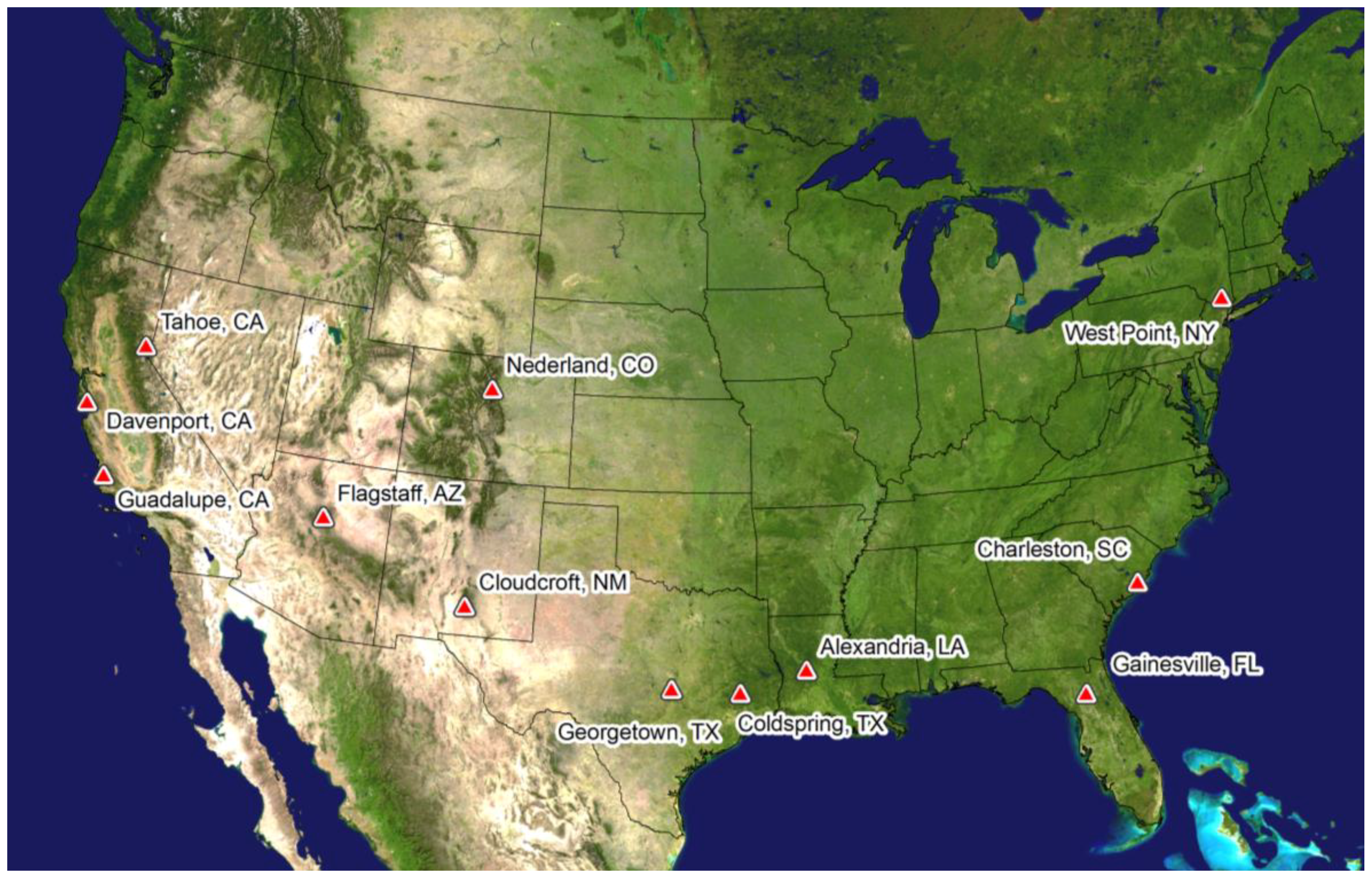
2.1. Study Site
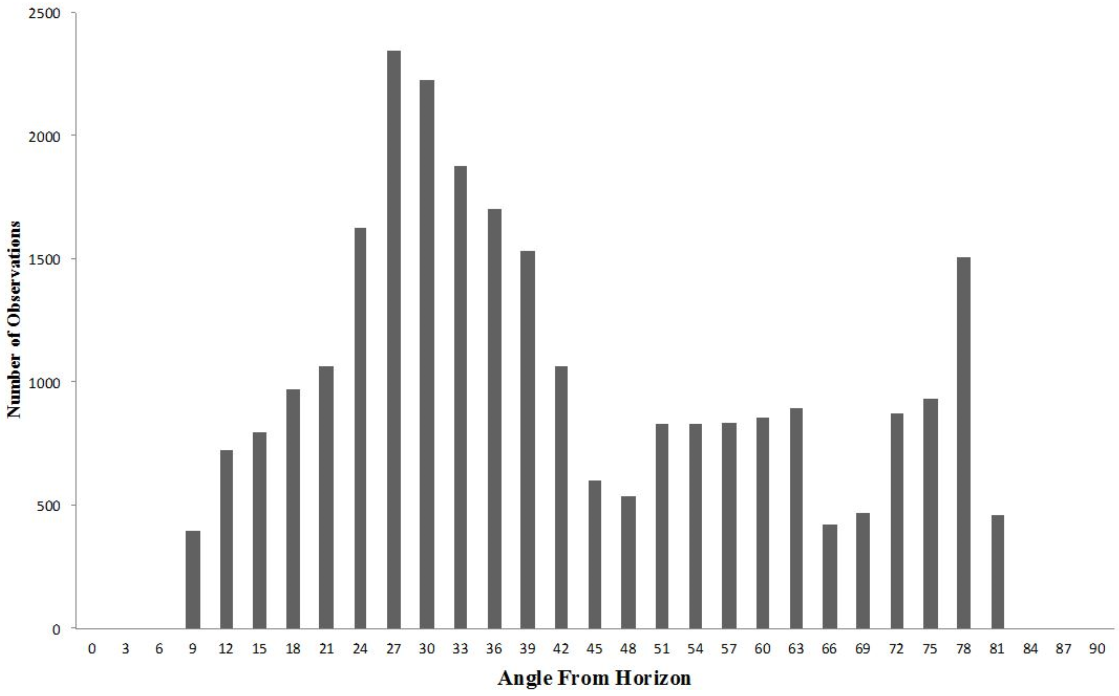
2.2. GPS Signal Observations
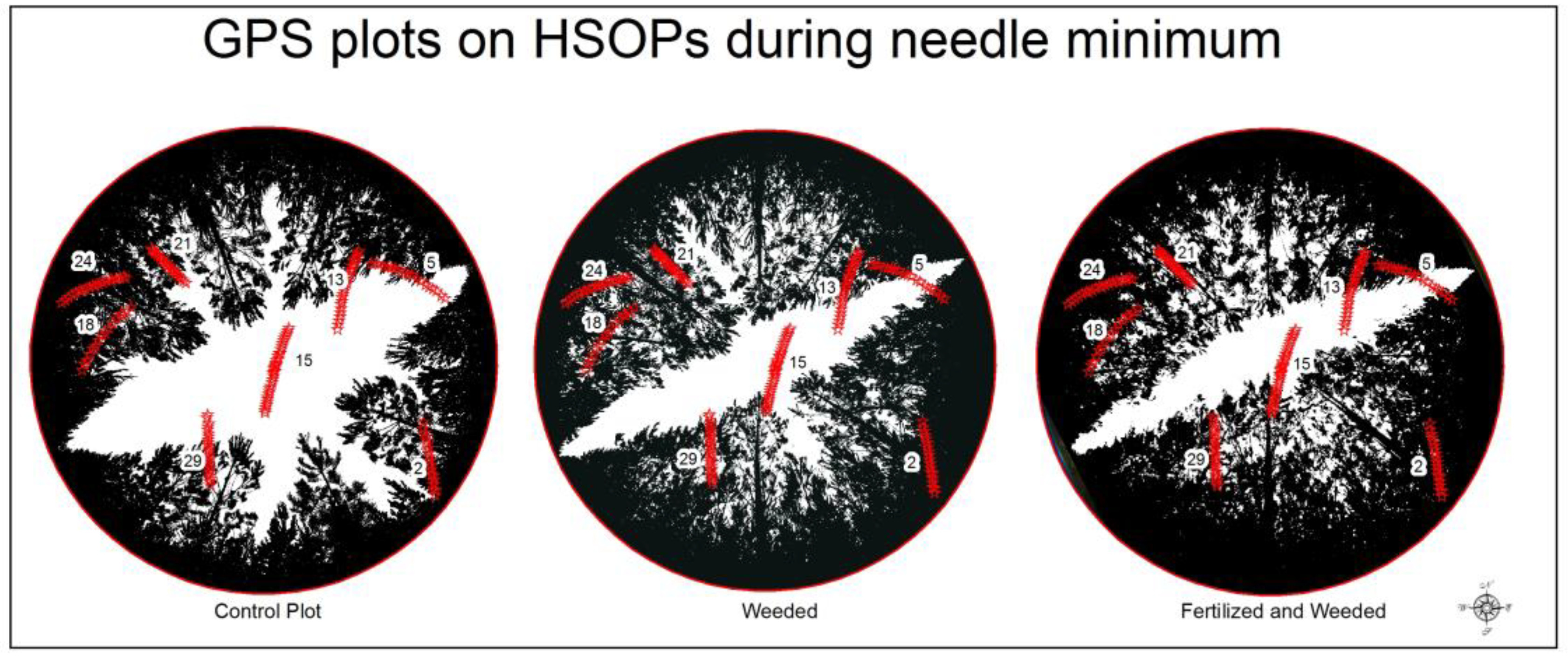
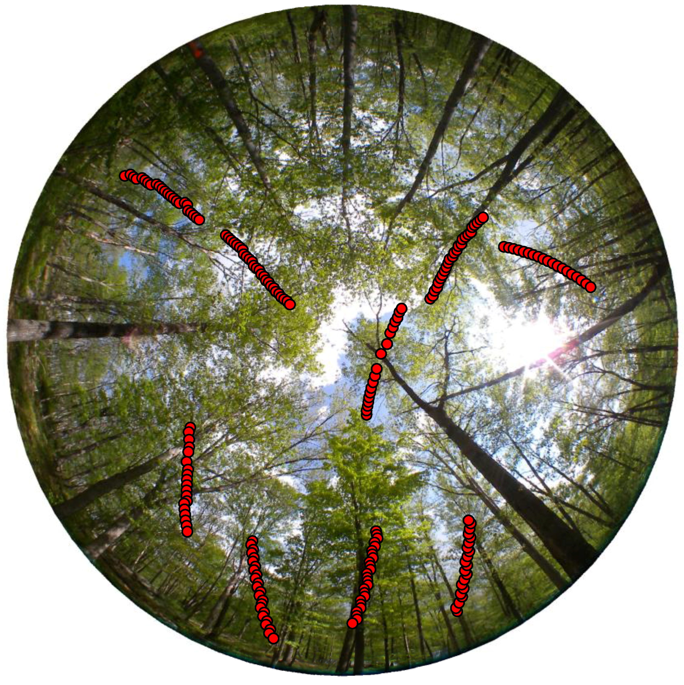
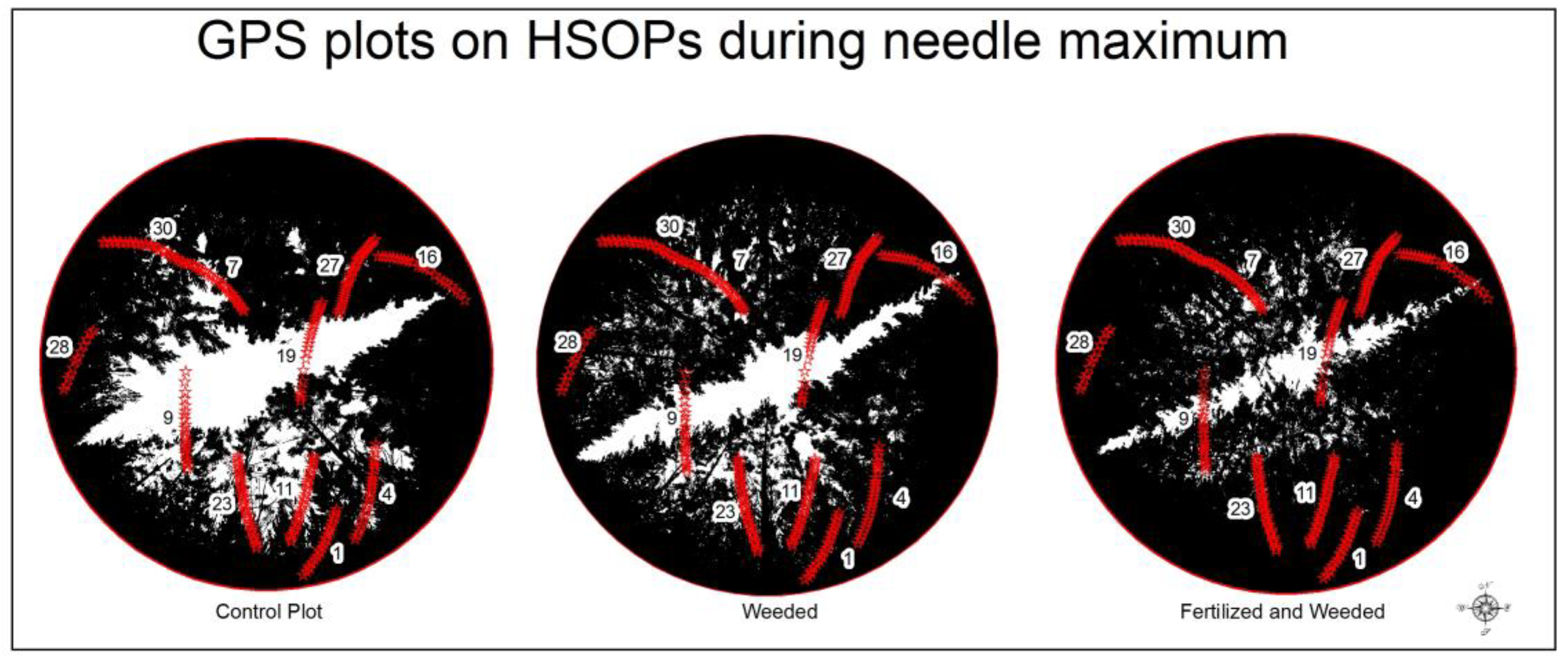
2.3. Hemispherical Sky-Oriented Photos and Image Processing
3. Results
4. Discussion
5. Conclusions
Author Contributions
Acknowledgments
Conflicts of Interest
References
- Wright, W.C.; Liu, P.-W.; Slatton, K.C.; Shrestha, R.L.; Carter, W.E.; Lee, H. Predicting L-Band Microwave Attenuation through Forest Canopy Using Directional Structuring Elements and Airborne Lidar. In Proceedings of the Geoscience and Remote Sensing Symposium (IGARSS 2008), Boston, MA, USA, 6–11 July 2008; pp. III-688–III-691. [Google Scholar]
- Lee, H.; Slatton, K.C.; Roth, B.; Cropper, W.P. Prediction of forest canopy light interception using three-dimensional airborne LiDAR data. Int. J. Remote Sens. 2009, 30, 189–207. [Google Scholar] [CrossRef]
- Lee, H.; Kampa, K.; Slatton, K.C. Segmentation of ALSM point data and the prediction of subcanopy sunlight distribution. In Proceedings of the Geoscience and Remote Sensing Symposium (IGARSS 2005), Seoul, Korea, 25–29 July 2005; p. 4. [Google Scholar]
- Lee, H.; Slatton, K.C.; Roth, B.; Cropper, W., Jr. Adaptive clustering of airborne LiDAR data to segment individual tree crowns in managed pine forests. Int. J. Remote Sens. 2010, 31, 117–139. [Google Scholar] [CrossRef]
- Holden, N.; Martin, A.; Owende, P.; Ward, S. A method for relating GPS performance to forest canopy. Int. J. For. Eng. 2001, 12, 51–56. [Google Scholar]
- Bode, C.A.; Limm, M.P.; Power, M.E.; Finlay, J.C. Subcanopy Solar Radiation model: Predicting solar radiation across a heavily vegetated landscape using LiDAR and GIS solar radiation models. Remote Sens. Environ. 2014, 154, 387–397. [Google Scholar] [CrossRef]
- Mücke, W.; Hollaus, M. Modelling light conditions in forests using airborne laser scanning data. In Proceedings of the SilviLaser 2011 Conference, Hobart, Australian, 16–20 October 2011. [Google Scholar]
- Gonzalez-Benecke, C.; Gezan, S.A.; Samuelson, L.J.; Cropper, W.P., Jr.; Leduc, D.J.; Martin, T.A. Estimating Pinus palustris tree diameter and stem volume from tree height, crown area and stand-level parameters. J. For. Res. 2014, 25, 43–52. [Google Scholar] [CrossRef]
- Bortolot, Z.J.; Wynne, R.H. Estimating forest biomass using small footprint LiDAR data: An individual tree-based approach that incorporates training data. ISPRS J. Photogramm. Remote Sens. 2005, 59, 342–360. [Google Scholar] [CrossRef]
- Drake, J.B.; Dubayah, R.O.; Knox, R.G.; Clark, D.B.; Blair, J.B. Sensitivity of large-footprint lidar to canopy structure and biomass in a neotropical rainforest. Remote Sens. Environ. 2002, 81, 378–392. [Google Scholar] [CrossRef]
- Hosoi, F.; Omasa, K. Estimating vertical plant area density profile and growth parameters of a wheat canopy at different growth stages using three-dimensional portable lidar imaging. ISPRS J. Photogramm. Remote Sens. 2009, 64, 151–158. [Google Scholar] [CrossRef]
- Kucharik, C.J.; Norman, J.M.; Gower, S.T. Characterization of radiation regimes in nonrandom forest canopies: Theory, measurements, and a simplified modeling approach. Tree Physiol. 1999, 19, 695–706. [Google Scholar] [CrossRef] [PubMed]
- Mätzler, C. Microwave transmissivity of a forest canopy: Experiments made with a beech. Remote Sens. Environ. 1994, 48, 172–180. [Google Scholar] [CrossRef]
- Wright, W.; Wilkinson, B.; Cropper, W. Estimating Signal Loss in Pine Forests Using Hemispherical Sky Oriented Photos. Ecol. Inf. 2016, 38, 82–88. [Google Scholar] [CrossRef]
- Wright, W.; Wilkinson, B. Modeling GPS Signal Loss in Forests Using Terrestrial Photogrammetric Methods. In Proceedings of the 28th International Technical Meeting of The Satellite Division of the Institute of Navigation, Tampa, FL, USA, 14–18 September 2015; pp. 3094–3099. [Google Scholar]
- Manninen, T.; Korhonen, L.; Voipio, P.; Lahtinen, P.; Stenberg, P. Leaf area index (LAI) estimation of boreal forest using wide optics airborne winter photos. Remote Sens. 2009, 1, 1380–1394. [Google Scholar] [CrossRef]
- Wright, W.C. Quantifying Global Position System Signal Attenuation as a Function of Three-Dimensional Forest Canopy Structure; University of Florida: Gainesville, FL, USA, 2008. [Google Scholar]
- Frazer, G.W.; Fournier, R.A.; Trofymow, J.; Hall, R.J. A comparison of digital and film fisheye photography for analysis of forest canopy structure and gap light transmission. Agric. For. Meteorol. 2001, 109, 249–263. [Google Scholar] [CrossRef]
- Rich, P.M. Characterizing plant canopies with hemispherical photographs. Remote Sens. Rev. 1990, 5, 13–29. [Google Scholar] [CrossRef]
- Anderson, M.C. Studies of the woodland light climate: I. The photographic computation of light conditions. J. Ecol. 1964, 52, 27–41. [Google Scholar] [CrossRef]
- Wright, W.; Wilkinson, B.; Cropper, W. Estimating GPS Signal Loss in a Natural Deciduous Forest Using Sky Photography. Pap. Appl. Geogr. 2017, 3, 119–128. [Google Scholar] [CrossRef]
- Larsen, D.R.; Kershaw, J.A., Jr. Influence of canopy structure assumptions on predictions from Beer’s law. A comparison of deterministic and stochastic simulations. Agric. For. Meteorol. 1996, 81, 61–77. [Google Scholar] [CrossRef]
- Oker-Blom, P. Photosynthetic radiation regime and canopy structure in modeled forest stands. Acta For. Fenn. 1986, 197, 1–44. [Google Scholar] [CrossRef]
- Neumann, H.; den Hartog, G.; Shaw, R. Leaf area measurements based on hemispheric photographs and leaf-litter collection in a deciduous forest during autumn leaf-fall. Agric. For. Meteorol. 1989, 45, 325–345. [Google Scholar] [CrossRef]


| ID | City Vicinity | Tree Type | Date (ddmmyy) | HT/STD (m) | DBH/STD (m) | Notes |
|---|---|---|---|---|---|---|
| 1 | West Point, NY | Oak/Hickory | 110515 | 23.4/3.4 | 0.30/0.18 | Military |
| 100% Deciduous | 100815 | Reservation | ||||
| 241015 | ||||||
| 170216 | ||||||
| 2 | IMPAC | 100% Pine | Managed Forest | |||
| Gainesville, FL | Control Plot | 110215/250815 | 5.77/1.4 | 0.09/0.05 | Fertilization | |
| Gainesville, FL | Weeded Plot | 110215/250815 | 8.21/0.64 | 0.12/0.04 | Research plots | |
| Fertilized and Weeded | 110215/250815 | 9.05/0.67 | 0.13/0.06 | |||
| 3 | Hogtown Forest | 80% Deciduous | 050216 | 20.4/2.47 | 0.46/0.08 | Uplands Natural Mixed Forest |
| Gainesville, FL | 20% Coniferous | Loblolly Woods Nature Park | ||||
| 4 | Charleston, SC | 90% Pine, 10% Deciduous | 230516 | 24.0/3.1 | 0.36/0.05 | Francis Marion National Forest |
| 5 | Alexandria, LA | 90% Pine, 10% Deciduous | 190616 | 23.2/4.1 | 0.56/0.11 | Kisatchie National Forest |
| 6 | Cold Spring, TX | 80% Pine, 20% Deciduous | 200616 | 19.5/4.7 | 0.52/0.13 | Sam Houston National Forest |
| 7 | Georgetown, TX | Ceder Elm and Live Oak with Ash Juniper | 220616 | 6.3/1.1 | 0.42/0.11 | North Fork of San Gabriel River |
| 8 | Cloudcroft, NM | Ponderosa Pine | 230616 | 23.3/3.2 | 0.41/0.12 | Lincoln National Forest |
| 9 | Flagstaff, AZ | Ponderosa Pine | 250616 | 19.2/6.8 | 0.41/0.07 | |
| 10 | Guadalupe, CA | Eucalyptus | 020716 | 28.2/3.3 | 0.42/0.14 | |
| 11 | San Luis Obispo | Agrifolia | 030716 | 6.9/1.5 | 0.22/0.09 | Military Base |
| 12 | Davenport, CA | 75% Redwood, 25% Douglas Fir and Tanoak | 050716 | 54.0/6.3 | 1.20/0.56 | California Polytechnic Research Center |
| 13 | Davenport, CA | 80% Tanoak, 25% Douglas Fir | 050716 | 18.7/1.4 | 0.28/0.08 | California Polytechnic Research Center |
| 14 | Tahoe NF | Ponderosa Pine | 070716 | 26.5/2.2 | 0.53/0.16 | University of California, Berkley Sagehen Experimental Forest |
| 15 | Nederland, CO | Aspen | 090716 | 8.4/2.6 | 0.20/0.06 |
| ID | City Vicinity | a | B1 | B2 | RMSE | Adj R2 |
|---|---|---|---|---|---|---|
| 1 | West Point, NY | 18.85 | 7.79 | −5.53 | 3.28 | 0.60 |
| 2 | IMPAC | 19.32 | 7.79 | −5.49 | 2.78 | 0.71 |
| 3 | Hogtown Forest, Gainesville, FL | 25.05 | 5.26 | −6.02 | 3.02 | 0.66 |
| 4 | Charleston, SC | 27.87 | 4.25 | −7.00 | 3.10 | 0.64 |
| 5 | Alexandria, LA | 25.77 | 4.87 | −5.24 | 3.03 | 0.60 |
| 6 | Cold Spring, TX | 26.89 | 5.61 | −16.35 | 2.80 | 0.59 |
| 7 | Georgetown, TX | 23.94 | 6.25 | −8.02 | 3.71 | 0.61 |
| 8 | Cloudcroft, NM | 25.71 | 5.99 | −6.99 | 3.77 | 0.60 |
| 9 | Flagstaff, AZ | 21.70 | 6.70 | −0.50 | 3.33 | 0.57 |
| 10 | Guadalupe, CA | 28.83 | 5.08 | −8.81 | 2.66 | 0.66 |
| 11 | San Luis Obispo | 26.26 | 5.79 | −29.39 | 3.75 | 0.60 |
| 12 | Davenport, CA | 27.50 | 5.46 | −6.03 | 2.83 | 0.72 |
| 13 | Davenport, CA | 27.50 | 3.15 | −14.49 | 3.02 | 0.70 |
| 14 | Tahoe NF | 30.03 | 4.56 | −8.59 | 3.24 | 0.70 |
| 15 | Nederland, CO | 31.04 | 4.79 | −12.99 | 2.83 | 0.74 |
| ID | City Vicinity | Tree Type | HT/STD (m) | DBH/STD (m) | SNR Index (dB) SFIM | SNR Index (dB) SSFIM | |
|---|---|---|---|---|---|---|---|
| 1 | West Point, NY | Oak/Hickory | 23.4/3.4 | 0.30/0.18 | Fall | –3.74 | –3.75 |
| 100% Deciduous | Spring | –5.43 | –5.44 | ||||
| Summer | –5.54 | –5.55 | |||||
| Winter | –4.37 | –4.38 | |||||
| 2 | IMPAC | 100% Pine | |||||
| Gainesville, FL | Needle Minimum | See Table 1 | See Table 1 | –3.31 | –3.32 | ||
| Gainesville, FL | Needle Maximum | See Table 1 | See Table 1 | –4.30 | –4.31 | ||
| 3 | Hogtown Forest | 80% Deciduous | 20.4/2.47 | 0.46/0.08 | –5.87 | –5.89 | |
| Gainesville, FL | 20% Coniferous | ||||||
| 4 | Charleston, SC | 90% Pine, 10% Deciduous | 24.0/3.1 | 0.36/0.05 | –7.68 | –7.69 | |
| 5 | Alexandria, LA | 90% Pine, 10% Deciduous | 23.2/4.1 | 0.56/0.11 | –6.48 | –6.49 | |
| 6 | Cold Spring, TX | 80% Pine, 20% Deciduous | 19.5/4.7 | 0.52/0.13 | –6.03 | –6.06 | |
| 7 | Georgetown, TX | Cedar Elm and Live Oak with Ash Juniper | 6.3/1.1 | 0.42/0.11 | –5.15 | –5.16 | |
| 8 | Cloudcroft, NM | Ponderosa Pine | 23.3/3.2 | 0.41/0.12 | –3.12 | –3.12 | |
| 9 | Flagstaff, AZ | Ponderosa Pine | 19.2/6.8 | 0.41/0.07 | –2.83 | –3.35 | |
| 10 | Guadalupe, CA | Eucalyptus | 28.2/3.3 | 0.42/0.14 | –5.02 | –5.02 | |
| 11 | San Luis Obispo | Agrifolia | 6.0/1.5 | 0.22/0.09 | –3.10 | –3.11 | |
| 12 | Davenport, CA | 75% Redwood, 25% Douglas Fir and Tanoak | 54.0/6.3 | 1.20/0.56 | –10.78 | –10.80 | |
| 13 | Davenport, CA | 80% Tanoak, 25% Douglas Fir | 18.7/1.4 | 0.28/0.08 | –8.05 | –8.07 | |
| 14 | Tahoe NF | Ponderosa Pine | 26.5/2.2 | 0.53/0.16 | –3.98 | –3.98 | |
| 15 | Nederland, CO | Aspen | 8.4/2.6 | 0.20/0.06 | –4.99 | –5.00 | |
© 2018 by the authors. Licensee MDPI, Basel, Switzerland. This article is an open access article distributed under the terms and conditions of the Creative Commons Attribution (CC BY) license (http://creativecommons.org/licenses/by/4.0/).
Share and Cite
Wright, W.; Wilkinson, B.; Cropper, W., Jr. Development of a GPS Forest Signal Absorption Coefficient Index. Forests 2018, 9, 226. https://doi.org/10.3390/f9050226
Wright W, Wilkinson B, Cropper W Jr. Development of a GPS Forest Signal Absorption Coefficient Index. Forests. 2018; 9(5):226. https://doi.org/10.3390/f9050226
Chicago/Turabian StyleWright, William, Benjamin Wilkinson, and Wendell Cropper, Jr. 2018. "Development of a GPS Forest Signal Absorption Coefficient Index" Forests 9, no. 5: 226. https://doi.org/10.3390/f9050226
APA StyleWright, W., Wilkinson, B., & Cropper, W., Jr. (2018). Development of a GPS Forest Signal Absorption Coefficient Index. Forests, 9(5), 226. https://doi.org/10.3390/f9050226