Near-Real-Time Monitoring of Insect Defoliation Using Landsat Time Series

Abstract
:1. Introduction
2. Materials and Methods
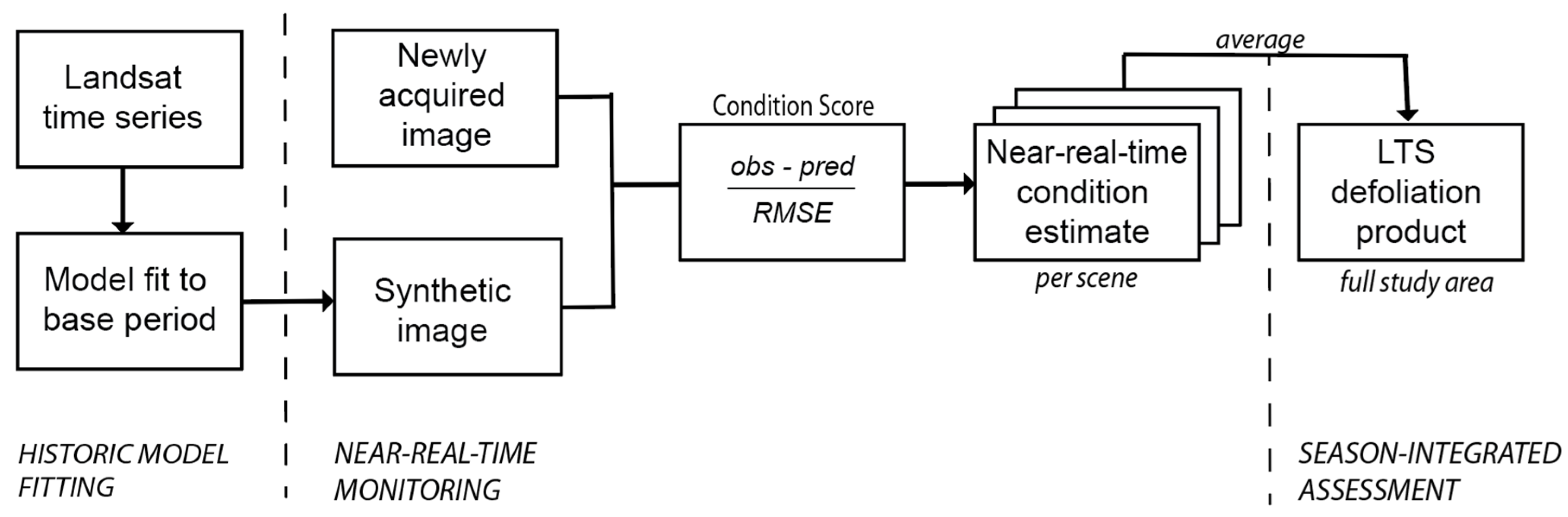
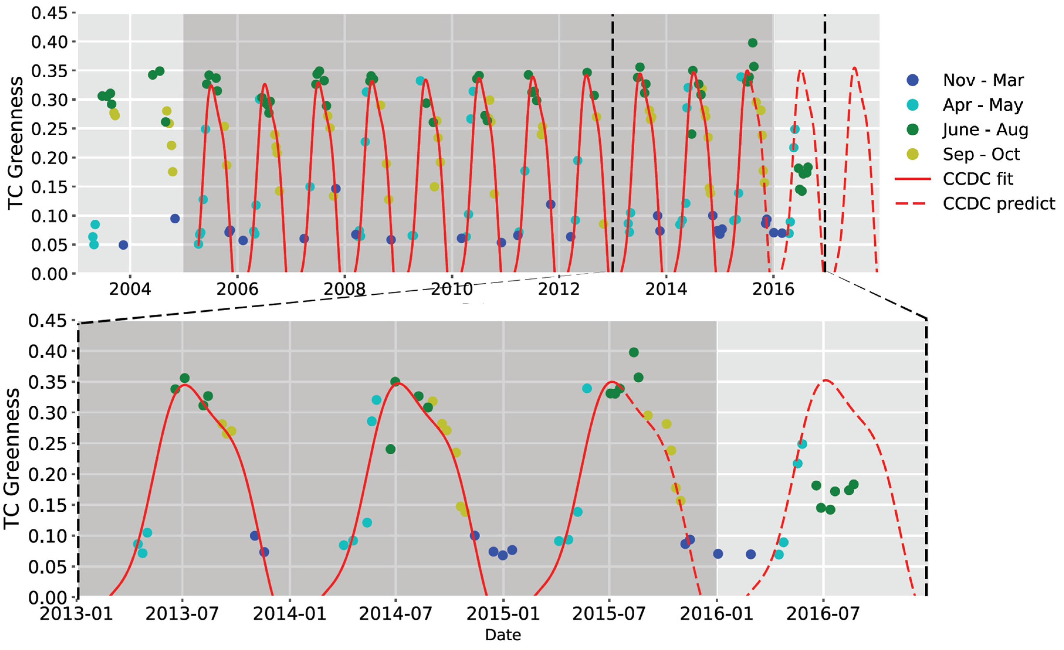
2.1. Historic Model Fitting
2.2. Near-Real-Time Monitoring
2.3. Season-Integrated Defoliation Assessment
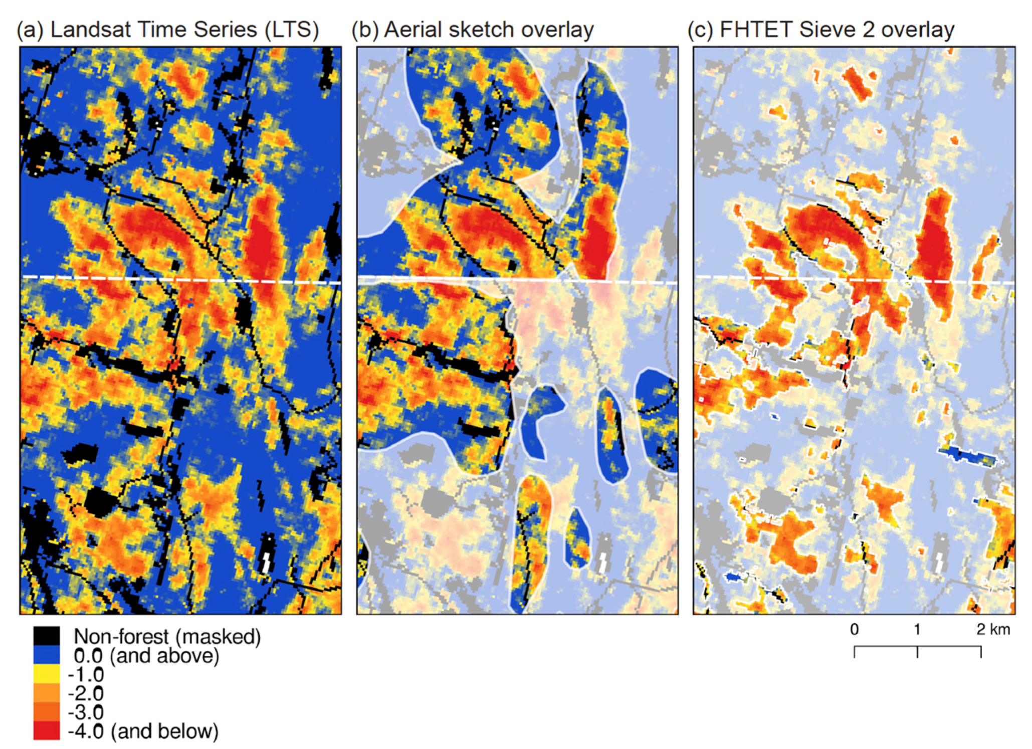
2.4. Comparison to Existing Defoliation Products
3. Results
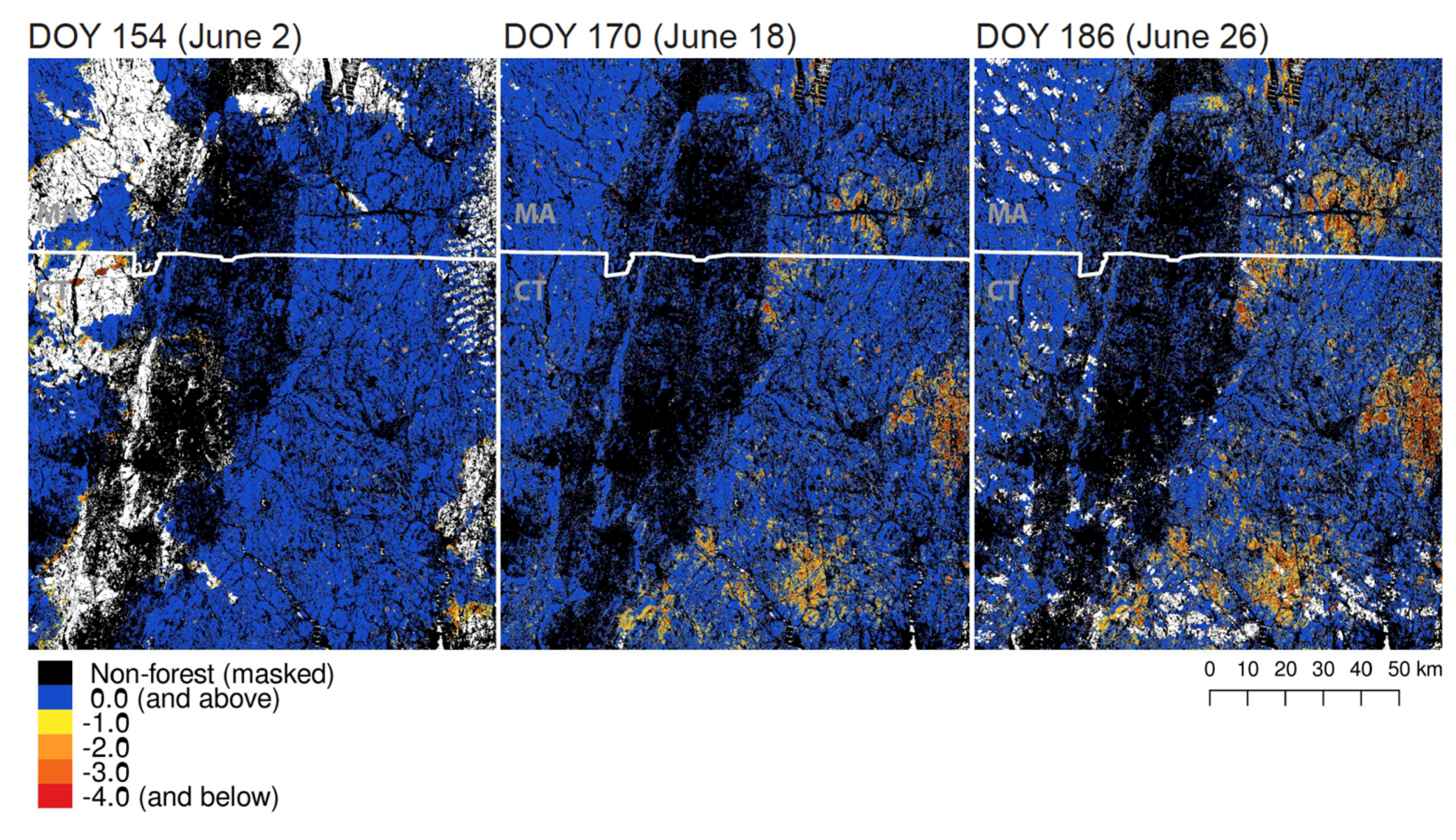
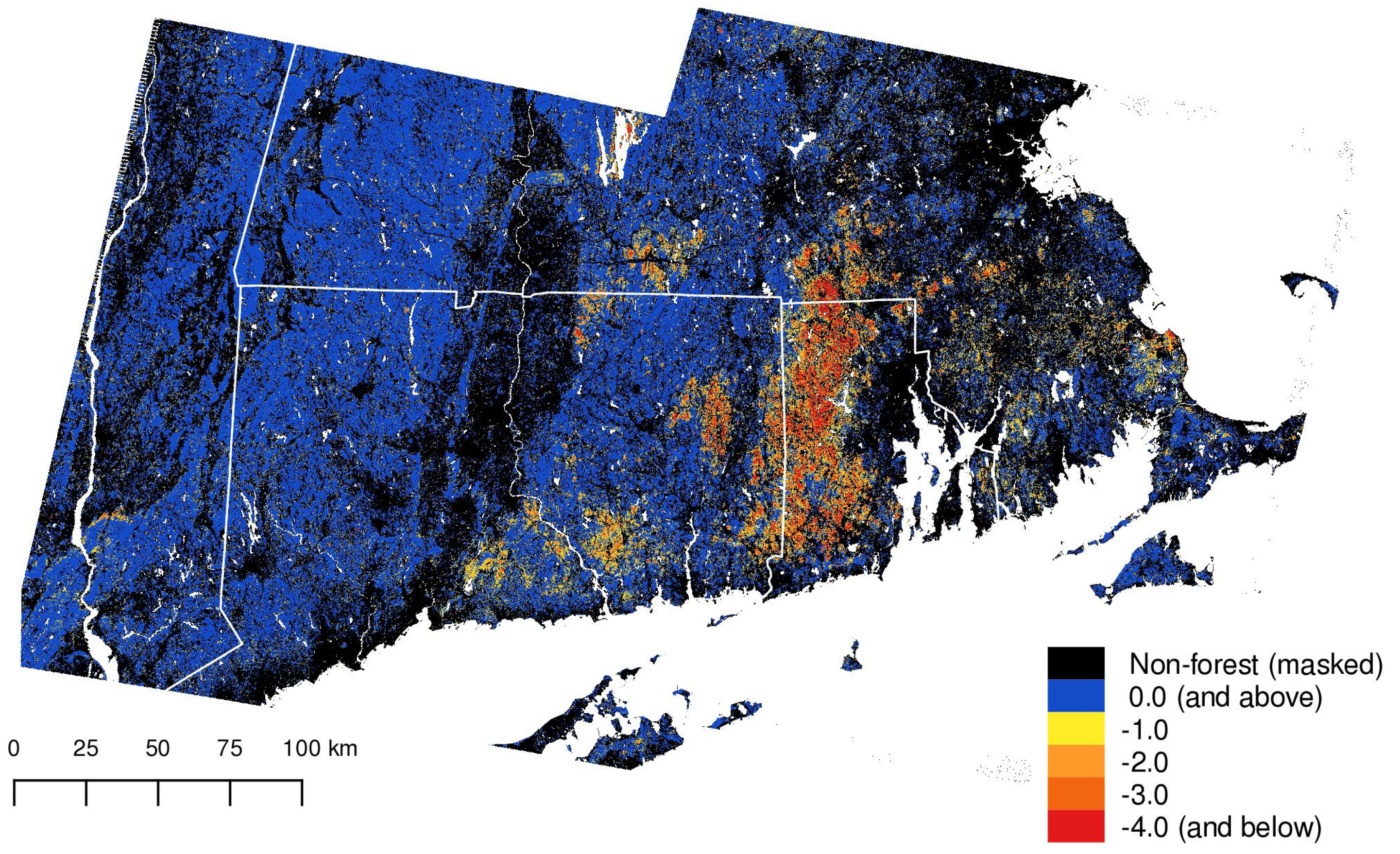
3.1. Mapping and Monitoring
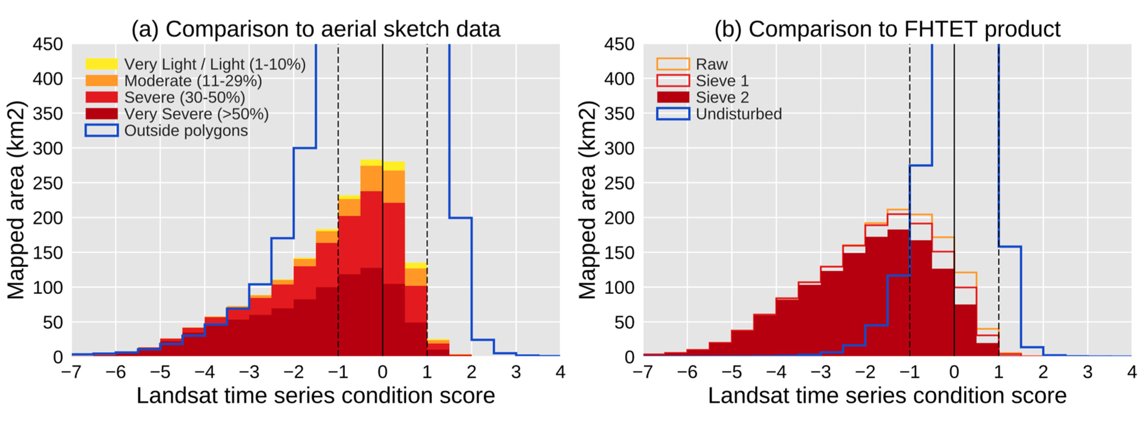
3.2. Comparison with Other Defoliation Products
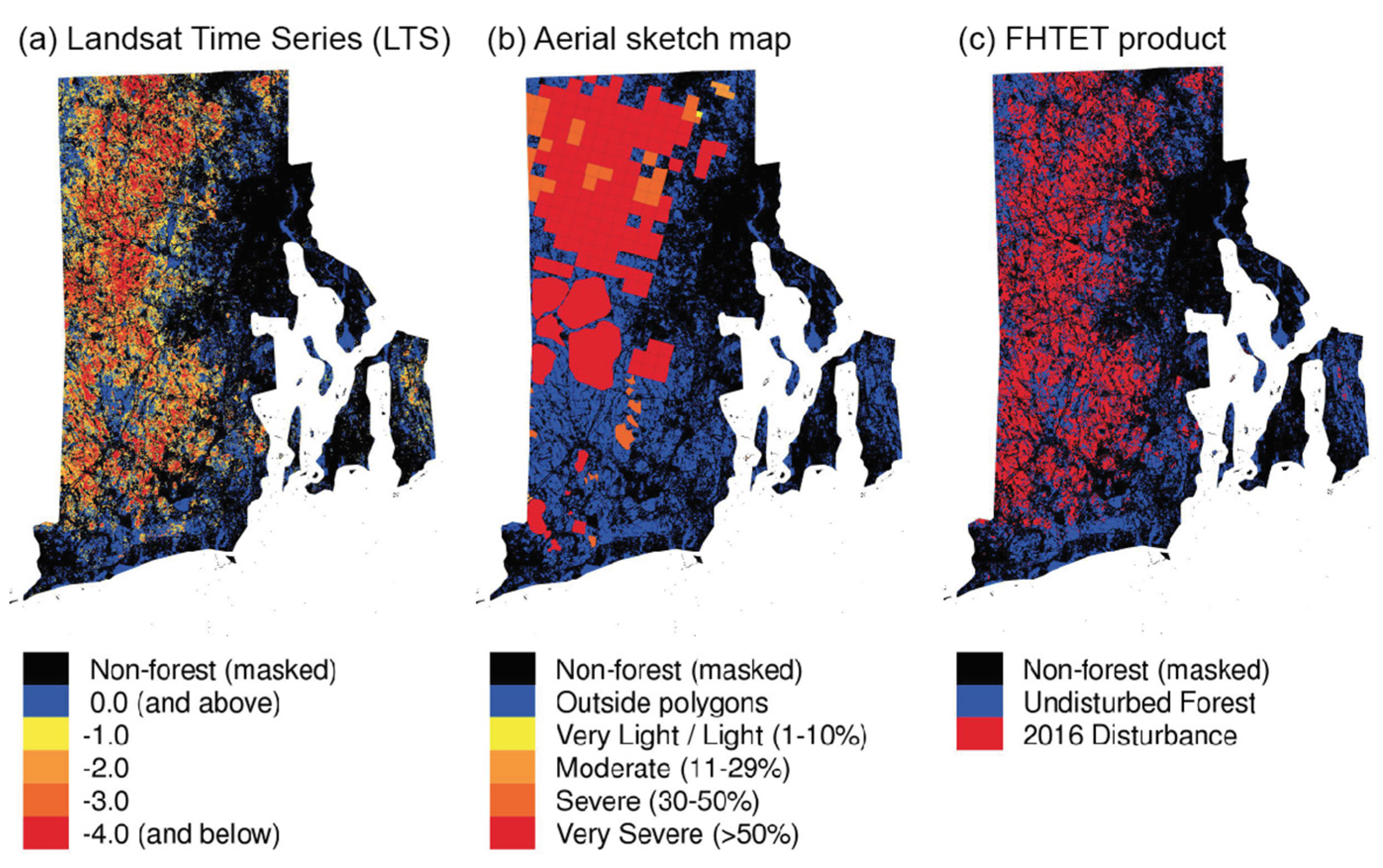
3.3. State-Level Defoliation Assessment: Rhode Island
4. Discussion
4.1. Advantages of the LTS Synthetic Image Approach
4.2. Comparison to Other Defoliation Products
4.3. Spectral Considerations
4.4. Generalization in the Spatial and Temporal Domains
4.5. Toward an Integrated Disturbance Monitoring System
5. Conclusions
Supplementary Materials
Acknowledgments
Author Contributions
Conflicts of Interest
References
- Pimentel, D.; Lach, L.; Zuniga, R.; Morrison, D. Environmental and economic costs of nonindigenous species in the United States. BioScience 2000, 50, 53–65. [Google Scholar] [CrossRef]
- Aukema, J.E.; McCullough, D.G.; Von Holle, B.; Liebhold, A.M.; Britton, K.; Frankel, S.J. Historical accumulation of nonindigenous forest pests in the continental United States. BioScience 2010, 60, 886–897. [Google Scholar] [CrossRef]
- Hall, R.J.; Skakun, R.S.; Arsenault, E.J. Remotely sensed data in the mapping of insect defoliation. In Understanding Forest Disturbance and Spatial Pattern: Remote Sensing and GIS Approaches; Wulder, M.A., Franklin, S.E., Eds.; CRC Press, Taylor and Francis: Boca Raton, FL, USA, 2006; pp. 85–111. [Google Scholar]
- Lovett, G.M.; Weiss, M.; Liebhold, A.M.; Holmes, T.P.; Leung, B.; Lambert, K.F.; Orwig, D.A.; Campbell, F.T.; Rosenthal, J.; McCullough, D.G.; et al. Nonnative forest insects and pathogens in the United States: Impacts and policy options. Ecol. Appl. 2016, 26, 1437–1455. [Google Scholar] [CrossRef] [PubMed]
- Liebhold, A.M.; Rossi, R.E.; Kemp, W.P. Geostatistics and geographic information systems in applied insect ecology. Annu. Rev. Entomol. 1993, 38, 303–327. [Google Scholar] [CrossRef]
- Senf, C.; Seidl, R.; Hostert, P. Remote sensing of forest insect disturbances: Current state and future directions. Int. J. Appl. Earth Obs. Geoinf. 2017, 60, 49–60. [Google Scholar] [CrossRef]
- Elkinton, J.S.; Liebhold, A.M. Population dynamics of gypsy moth in North America. Annu. Rev. Entomol. 1990, 35, 571–596. [Google Scholar] [CrossRef]
- Régnière, J.; Nealis, V.; Porter, K. Climate suitability and management of the gypsy moth invasion into Canada. Biol. Invasions 2009, 11, 135–148. [Google Scholar] [CrossRef]
- Liebhold, A.M.; Elmes, G.A.; Halverson, J.A.; Quimby, J. Landscape characterization of forest susceptibility to gypsy moth defoliation. For. Sci. 1994, 40, 18–29. [Google Scholar]
- Gansner, D.A.; Herrick, O.W.; Mason, G.N.; Gottschalk, K.W. Coping with the gypsy moth on new frontiers of infestation. South. J. Appl. For. 1987, 11, 201–209. [Google Scholar]
- Barron, E.S.; Patterson, W.A., III. Monitoring the effects of gypsy moth defoliation on forest stand dynamics on Cape Cod, Massachusetts: Sampling intervals and appropriate interpretations. For. Ecol. Manag. 2008, 256, 2092–2100. [Google Scholar] [CrossRef]
- Morin, R.S.; Liebhold, A.M. Invasive forest defoliator contributes to the impending downward trend of oak dominance in eastern North America. Forestry 2016, 89, 284–289. [Google Scholar] [CrossRef]
- Liebhold, A.M.; Halverson, J.A.; Elmes, G.A. Gypsy moth invasion in North America: A quantitative analysis. J. Biogeogr. 1992, 19, 513–520. [Google Scholar] [CrossRef]
- Gray, D.R. The gypsy moth life stage model: Landscape-wide estimates of gypsy moth establishment using a multi-generational phenology model. Ecol. Model. 2004, 176, 155–171. [Google Scholar] [CrossRef]
- Williams, D.L.; Ingram, K.J. Integration of digital elevation model data and Landsat MSS data to quantify the effects of slope orientation on the classification of forest canopy condition. In Proceedings of the Seventh International Symposium Machine Processing of Remotely Sensed Data with special emphasis on Range, Forest and Wetlands Assessment, Purdue University, West Lafayette, IN, USA, 23–26 June 1981; Paper 445. Available online: http://docs.lib.purdue.edu/lars_symp/445/ (accessed on 26 Jul 2017).
- Nelson, R.F. Detecting forest canopy change due to insect activity using Landsat MSS. Photogramm. Eng. Remote Sens. 1983, 49, 1303–1314. [Google Scholar]
- Dottavio, C.L.; Williams, D.L. Satellite technology: An improved means for monitoring forest insect defoliation. J. For. 1983, 81, 30–34. [Google Scholar]
- Williams, D.L.; Nelson, R.F. Use of remotely sensed data for assessing forest stand conditions in the eastern United States. IEEE Trans. Geosci. Remote Sens. 1986, 1, 130–138. [Google Scholar] [CrossRef]
- Rock, B.N.; Vogelmann, J.E.; Williams, D.L.; Vogelmann, A.F.; Hoshizaki, T. Remote detection of forest damage. BioScience 1986, 36, 439–445. [Google Scholar] [CrossRef]
- Rullan-Silva, C.D.; Olthoff, A.E.; de la Mata, J.D.; Pajares-Alonso, J.A. Remote monitoring of forest insect defoliation-A review. For. Syst. 2013, 22, 377. [Google Scholar] [CrossRef]
- Townsend, P.A.; Singh, A.; Foster, J.R.; Rehberg, N.J.; Kingdon, C.C.; Eshleman, K.N.; Seagle, S.W. A general Landsat model to predict canopy defoliation in broadleaf deciduous forests. Remote Sens. Environ. 2012, 119, 255–265. [Google Scholar] [CrossRef]
- Zhu, Z.; Woodcock, C.E.; Holden, C.; Yang, Z. Generating synthetic Landsat images based on all available Landsat data: Predicting Landsat surface reflectance at any given time. Remote Sens. Environ. 2015, 162, 67–83. [Google Scholar] [CrossRef]
- Defoliators v0.1. Available online: https://github.com/valpasq/defoliators/releases/tag/v0.1 (accessed on 3 July 2017).
- Pasquarella, V. 2016 Gypsy Moth Assessment—Southern New England [Data Set]. Zenodo. Available online: http://doi.org/10.5281/zenodo.801800 (accessed on 26 Jul 2017).
- ESPA On-Demand Interface. Available online: https://espa.cr.usgs.gov/ (accessed on 31 May 2017).
- Holden, C.E.; Arevelo, P.; Pasquarella, V. Yet Another Time Series Model (YATSM): V0.6.1. Available online: https://github.com/ceholden/yatsm/releases/tag/v0.6.1 (accessed on 31 May 2017).
- Zhu, Z.; Woodcock, C.E.; Olofsson, P. Continuous monitoring of forest disturbance using all available Landsat imagery. Remote Sens. Environ. 2012, 122, 75–91. [Google Scholar] [CrossRef]
- Zhu, Z.; Woodcock, C.E. Continuous change detection and classification of land cover using all available Landsat data. Remote Sens. Environ. 2014, 144, 152–171. [Google Scholar] [CrossRef]
- De Beurs, K.; Townsend, P. Estimating the effect of gypsy moth defoliation using MODIS. Remote Sens. Environ. 2008, 112, 3983–3990. [Google Scholar] [CrossRef]
- Pasquarella, V.J.; Holden, C.E.; Kaufman, L.; Woodcock, C.E. From imagery to ecology: Leveraging time series of all available Landsat observations to map and monitor ecosystem state and dynamics. Remote Sens. Ecol. Conserv. 2016, 2, 152–170. [Google Scholar] [CrossRef]
- Crist, E.P. A TM tasseled cap equivalent transformation for reflectance factor data. Remote Sens. Environ. 1985, 17, 301–306. [Google Scholar] [CrossRef]
- Kennedy, R.E.; Yang, Z.; Cohen, W.B. Detecting trends in forest disturbance and recovery using yearly Landsat time series: 1. LandTrendr--Temporal segmentation algorithms. Remote Sens. Environ. 2010, 114, 2897–2910. [Google Scholar] [CrossRef]
- Holden, C.E.; Woodcock, C.E. An analysis of Landsat 7 and Landsat 8 underflight data and the implications for time series investigations. Remote Sens. Environ. 2016, 185, 16–36. [Google Scholar] [CrossRef]
- Vogelmann, J.E.; Gallant, A.L.; Shi, H.; Zhu, Z. Perspectives on monitoring gradual change across the continuity of Landsat sensors using time-series data. Remote Sens. Environ. 2016, 185, 258–270. [Google Scholar] [CrossRef]
- Zhu, Z.; Gallant, A.L.; Woodcock, C.E.; Pengra, B.; Olofsson, P.; Loveland, T.R.; Jin, S.; Dahal, D.; Yang, L.; Auch, R.F. Optimizing selection of training and auxiliary data for operational land cover classification for the LCMAP initiative. ISPRS J. Photogramm. Remote Sens. 2016, 122, 206–221. [Google Scholar] [CrossRef]
- Chastain, R.A.; Housman, I.W.; Clark, J. Using Google Earth Engine to Automate Forest Disturbance Detection in Near-Real Time: A Case Study that Increased Efficiencies by 80 Percent; RSAC-10091-TIP1; USDA Forest Service: Salt Lake City, UT, USA, 2015. [Google Scholar]
- Spruce, J.P.; Sader, S.; Ryan, R.E.; Smoot, J.; Kuper, P.; Ross, K.; Prados, D.; Russell, J.; Gasser, G.; McKellip, R.; et al. Assessment of MODIS NDVI time series data products for detecting forest defoliation by gypsy moth outbreaks. Remote Sens. Environ. 2011, 115, 427–437. [Google Scholar] [CrossRef]
- Deel, L.N.; McNeil, B.E.; Curtis, P.G.; Serbin, S.P.; Singh, A.; Eshleman, K.N.; Townsend, P.A. Relationship of a Landsat cumulative disturbance index to canopy nitrogen and forest structure. Remote Sens. Environ. 2012, 118, 40–49. [Google Scholar] [CrossRef]
- Healey, S.; Cohen, W.; Zhiqiang, Y.; Krankina, O. Comparison of Tasseled Cap-based Landsat data structures for use in forest disturbance detection. Remote Sens. Environ. 2005, 97, 301–310. [Google Scholar] [CrossRef]
- Foster, J.R.; Townsend, P.A.; Mladenoff, D.J. Spatial dynamics of a gypsy moth defoliation outbreak and dependence on habitat characteristics. Landsc. Ecol. 2013, 28, 1307–1320. [Google Scholar] [CrossRef]
- Johnson, E.W.; Ross, J. Quantifying error in aerial survey data. Aust. For. 2008, 71, 216–222. [Google Scholar] [CrossRef]
- Elkinton, J.; Boettner, G.; Liebhold, A.; Gwiazdowski, R. Biology, Spread, and Biological Control of Winter Moth in the Eastern United States; FHTET-2014-07; U.S. Department of Agriculture, Forest Service, Forest Health Technology Team: Morgantown, WV, USA, 2015; 22 p, Available online: https://www.fs.fed.us/nrs/pubs/jrnl/2015/fhtet-2014-07_elkinton_2015_001.pdf (accessed on 1 June 2017).
- Mandanici, E.; Bitelli, G. Preliminary Comparison of Sentinel-2 and Landsat 8 Imagery for a Combined Use. Remote Sens. 2016, 8, 1014. [Google Scholar] [CrossRef]
- Yan, L.; Roy, D.P.; Zhang, H.; Li, J.; Huang, H. An automated approach for sub-pixel registration of Landsat-8 Operational Land Imager (OLI) and Sentinel-2 Multi Spectral Instrument (MSI) imagery. Remote Sens. 2016, 8, 520. [Google Scholar] [CrossRef]
- Flood, N. Comparing Sentinel-2A and Landsat 7 and 8 Using Surface Reflectance over Australia. Remote Sens. 2017, 9, 659. [Google Scholar] [CrossRef]


| WRS-2 | DOY | Date |
|---|---|---|
| 12/31 | 2016-171 | 19 June |
| 12/31 | 2016-179 | 27 June |
| 12/31 | 2016-195 | 13 July |
| 12/31 | 2016-203 | 21 July |
| 12/31 | 2016-227 | 14 August |
| 12/31 | 2016-235 | 22 August |
| 12/31 | 2016-243 | 30 August |
| 13/31 | 2016-170 | 18 June |
| 13/31 | 2016-178 | 26 June |
| 13/31 | 2016-186 | 4 July |
| 13/31 | 2016-194 | 12 July |
| 13/31 | 2016-202 | 20 July |
| 13/31 | 2016-218 | 5 August |
| 13/31 | 2016-242 | 29 August |
| 13/31 | 2016-258 | 14 September |
| 13/31 | 2016-266 | 22 September |
| Dataset | Area Affected | Percent of RI Forest 1 |
|---|---|---|
| LTS (condition score < −1) | 618 km2 | 49.3% |
| LTS (condition score < −2) | 387 km2 | 30.9% |
| LTS (condition score < −3) | 220 km2 | 17.6% |
| FHTET (Sieve 2) | 641 km2 | 51.2% |
| Aerial (>50% defoliation, Level 5) | 448 km2 | 35.8% |
| Aerial (>30% defoliation, Levels 4, 5) | 520 km2 | 41.5% |
| Aerial (>11% defoliation, Levels 3, 4, 5) | 525 km2 | 41.9% |
© 2017 by the authors. Licensee MDPI, Basel, Switzerland. This article is an open access article distributed under the terms and conditions of the Creative Commons Attribution (CC BY) license (http://creativecommons.org/licenses/by/4.0/).
Share and Cite
Pasquarella, V.J.; Bradley, B.A.; Woodcock, C.E. Near-Real-Time Monitoring of Insect Defoliation Using Landsat Time Series. Forests 2017, 8, 275. https://doi.org/10.3390/f8080275
Pasquarella VJ, Bradley BA, Woodcock CE. Near-Real-Time Monitoring of Insect Defoliation Using Landsat Time Series. Forests. 2017; 8(8):275. https://doi.org/10.3390/f8080275
Chicago/Turabian StylePasquarella, Valerie J., Bethany A. Bradley, and Curtis E. Woodcock. 2017. "Near-Real-Time Monitoring of Insect Defoliation Using Landsat Time Series" Forests 8, no. 8: 275. https://doi.org/10.3390/f8080275
APA StylePasquarella, V. J., Bradley, B. A., & Woodcock, C. E. (2017). Near-Real-Time Monitoring of Insect Defoliation Using Landsat Time Series. Forests, 8(8), 275. https://doi.org/10.3390/f8080275