1. Introduction
1.1. Forestry in Finland
In Finland, forests cover 70% of the land area, and, over the course of history, livelihoods derived from forests have been the cornerstone of the economy. Currently, the forest sector contributes about 5% of Finland’s gross domestic product [
1]. More than half of the forestland in Finland is privately owned. In Southern Finland, this figure reaches about 80% [
2].
The main forest-related concern has been how to maximize forest growth and develop an incentive structure to make that possible. The Finnish model has been highly effective in terms of supporting forest growth, but not in terms of safeguarding biodiversity and species protection [
3,
4]. As in many other countries, it has not been easy to combine the goals of forestry and nature conservation policies in Finland [
5]. The degradation of environmental values in favor of economic ones has been recognized in previous studies: forest owners are usually eager to make a profit at the expense of conservation requirements [
6]. Therefore, the Finnish forestry model is often heavily criticized by non-governmental organizations (NGOs) for a strong emphasis on economical aspects and less on social and environmental aspects [
7,
8,
9].
Private forest owners, including large companies, are an especially relevant group of stakeholders as 69% of productive forests in Finland are privately owned [
10], and private owners are key decision makers in regard to the growth, maintenance and harvesting of their forests. Moreover, private forest owners are major suppliers of raw materials for the forest sector and are responsible for more than 70% of the delivered volume [
1]. Other key decision makers include nature conservation organizations and environmental authorities, with whom these forest owners have traditionally been in opposition [
6].
1.2. Role of Forest Certification in Finland
World War II resulted in substantial biodiversity loss and fragmentation of forest landscapes. Maintaining a balance between economic, social, and environmental sustainability on a local level was put to the side. However, a new voluntary scheme emerged in the 1990s that aimed to take all three dimensions into equal consideration [
11]. Thus, two major certification schemes appeared in the international arena—the PEFC and the Forest Stewardship Council (FSC)—both highly relevant for Finnish conditions.
How do we define “certification,” and what does it mean for landowners to “certify” their forests? Rather than a more formal proof of forest management, certification indicates that the landowner has taken due care of management in accordance with a certain level of responsibility that fits the requirements of the standard. Thus, certification implies that the landowner understands the level of requirements; an independent expert provides an unbiased assessment of the management procedures against a set of requirements in a checklist, and the data of the assessment are publicly available. Conversely, if any of the requirements are not fulfilled, the forest is deemed to be not properly managed and certification is withheld by the assessor [
12].
On 24 May 2000, the Pan European Forest Certification Council (PEFCC) members endorsed Finnish, Norwegian, and Swedish national forest certification schemes. The PEFC is a certification scheme defined by the European Forestry Ministers at conferences on the protection of European forests, and the previously existing Finnish Forest Certification Scheme (FFCS) became part of this umbrella organization [
13]. However, NGOs and indigenous peoples groups insist that PEFC has no credibility as it was developed in a top-down closed process, and they insist that the FSC offers the best option for forest certification [
9]. The Finnish Forest Industry Federation has also stated its dissatisfaction with two certification schemes existing in parallel, and has asked for a national effort to reach one common standard [
12]. Since 12 October 2015, the FSC National Standard covers less than 5% of forests in Finland [
14], which suggests a strong potential for growth in the future.
Of all the forest certification systems, the PEFC is cost-efficient for group certification and best adapted to the family-ownership-based Finnish forestry environment. In addition to individual forest owner certification, the PEFC also offers group certification at a reasonable cost, even when the participating forests are relatively small. Larger areas of forest owned by more than one owner means that the group certification actions for environmental protection, for example, can be concentrated where they are the most economically efficient [
15].
1.3. Reasoning and Objectives
Academic research on forest certification has increased substantially in recent years [
10], and numerous studies have been published regarding the development and implications of certification in different parts of the world [
16,
17,
18,
19,
20,
21,
22,
23,
24,
25,
26,
27,
28,
29,
30,
31,
32]. Many articles have highlighted the role of auditors on the quality of forest standards implementations and potential levels of bias [
33,
34,
35]. However, research on independent assessments and the use of the remote sensing geographical information system (RS-GIS) in the verification of indicators has not been carried out, although FSC International has begun incorporating RS-GIS techniques into their audit and monitoring procedures. FSC is in the process of implementing the Transparent Forest project [
36]; however, the research remains at the methodology design stage, and results are not yet publicly available.
The aim of this paper is to study the possibilities of using RS-GIS techniques to verify the indicators of the Finnish National Standard of PEFC certification based on freely available digital data in the country. The secondary aims of the study are to (1) provide an analysis of the Finnish National Standard of PEFC certification [
37]; (2) prove the concept that retrieved indicators can be verified with RS-GIS techniques; and (3) run a test analysis for verifiable indicators in Eastern Finland (Northern Karelia).
2. Materials and Methods
2.1. Analysis of the Standard
The Finnish Forest Certification System standard was analyzed on the basis of criteria applicable for verification against known, freely available Landsat data coupled with GIS analysis. The Finnish PEFC standard sets out 32 criteria for responsible forestry, which covers the economic, social, and ecological sustainability of forest management and use, and is concerned with the planning and implementation of forest management, workers’ rights, the training and advice provided to forest owners, and increasing young people’s knowledge of forestry [
37]. Together the criteria are more stringent than Finnish legislation and other regulations, which are themselves quite strict by international standards. The criteria focus special attention on the protection of ecologically valuable habitats and waterways, on the management of young forests, on training in forest management, and the harmonization of nature-based industries and forestry management.
Due to the repetition of indicators used to verify the different criteria of the standard, the first step was to construct a list of unique indicators used for verification. The indicators were then evaluated by experts to determine a reliable evaluation of the criterion with RS-GIS.
2.2. Study Area
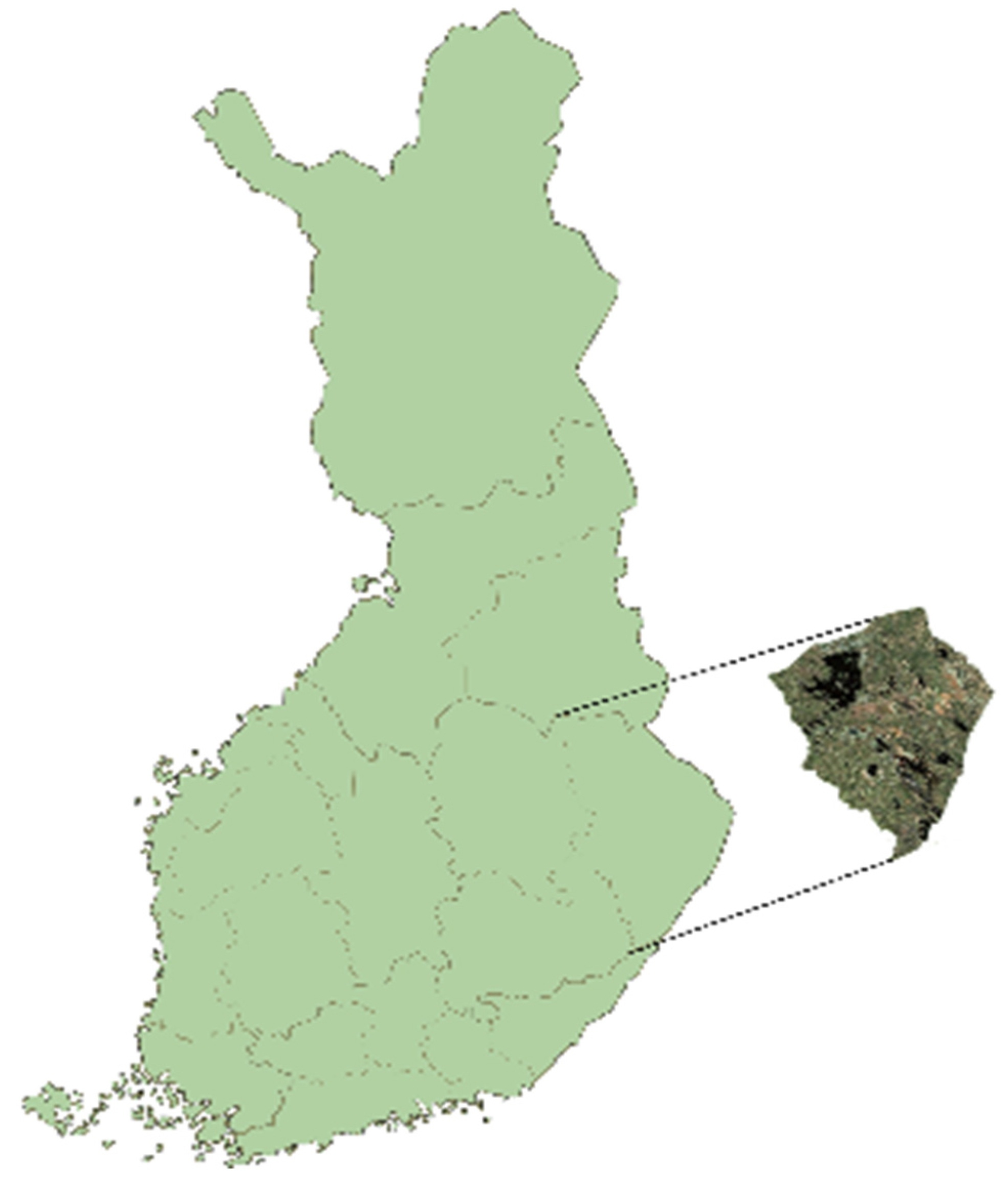
The case study area chosen is situated in the Ilomantsi commune, in the province of Eastern Finland and is part of the North Karelia region (
Figure 1). The municipality covers an area of 3172 km
2 of which 409 km
2 is water. The population density is 2.06 inhabitants per km
2. Neighboring municipalities are Lieksa and Joensuu. To the east, Ilomantsi shares a 100-km-long border with the Russian Republic of Karelia. The municipality is sparsely populated and is mostly characterized by forests and bogs. About 250 km
2 of the area is designated as a Natural Reserve and includes the Petkeljärvi and Patvinsuo National Parks. The Ilomantsi is known for its mires, old forests, forested hills, and water. The most important water bodies in Ilomantsi are Lakes Koitere and Nuorajärvi, and the Koitajoki River [
38]. One of the main sources of income for local people is forestry, which is why forest certification has been proposed as a way to satisfy market demands and potentially increase the value of extracted wood from the forest.
2.3. Forest Structure and Ownership
The forests in Ilomantsi are owned by private forest owners (59%), private companies (21%), and the state (20%). Forest stand characteristics and their distribution are crucial to understanding the productivity and condition of forests in the area. The ownership and age class distribution are presented in
Table 1.
The forestland in Ilomantsi is unevenly distributed (
Table 1), and the proportion of >100 years old stands is relatively small. In Finland, the optimal harvesting age for coniferous trees is about 70–80 years and for deciduous trees between 50–60 years. However the presence of old forests is a direct consequence of environmental programs, such as METSO, Natura 2000, and others [
15]. The proportion of overmature stands in state forests has also increased due to the existence of National Parks within the Ilomantsi commune. The main proportion of the forest volume is attributed to age class 41–60 years, followed by 21–40 and 61–80.
2.4. Preparation of GIS Data
The selected testing area (path 186, row 16 in the WRS-2 Landsat program) falls within the boundaries of the Ilomantsi commune. Low-cloud images were used for the analysis (cloudiness less than 20%) and were obtained by the Landsat 5 during the period 2001–2013 and provides images of the Earth’s surface with a spatial resolution of 30 m in 6 spectral bands. Approximate scene size is 170 km north–south by 183 km east–west [
39].
Available GIS datasets were used for the verification of the land cover changes detected from Landsat images cover assessment. In Finland, the majority of the GIS data is available via the environmental administration’s joint website, which can be accessed after registration with OIVA (Environment and Location service for experts) [
40]. The service provides environmental management data on water resources, surface water status, groundwater, living organisms, environmental protected territories, as well as the use of environment-related GIS data. Databases are generated and collected by state environmental agencies; in particular, the Centre for Economic Development, Transport and the Environment (ELY), and the Finnish Environment Institute (SYKE), among others. The service is primarily intended for GIS experts and is also free of charge.
The materials can be downloaded from entire comprehensive Finnish databases in ESRI formats. In addition, the contents have been published in the WMS interface services. Spatial data were downloaded from the ETRS-TM35FIN coordinate system in ESRI-shape format. The spatial accuracy of the data varies among the layers. The most accurate layers correspond to a map with a basic scale of 1:20000. Material-specific resolutions and other information are described in the metadata description, which can be found in each data package.
Evaluation of the average number of harvested forest sites in Finland during 2001–2013 was mapped using the online commercial application cloud-based remote sensing platform [
41]. Analyzed criteria were converted into logical decision trees in Definiens Image Intellegence Suite software, which allows an object-oriented interpretation of time series of satellite images.
3. Results
3.1. Analysis of the PEFC Standard
From the 32 criteria listed in the standard PEFC FI 1002:2014, 6 were verified with RS-GIS. Those criteria are presented in
Table 2.
The results of the expert analysis of standard 1002:2014 showed that 6 criteria out of a total of 32 (18%) were potentially suitable for verification with RS-GIS techniques. For evaluation of the criteria, the key features were detected using RS-GIS for the boundaries of the new and old harvested sites (2014–2015) and for newly constructed roads. Once these key features were identified and geographically referenced, they were compared with the layers of the protected areas (i.e., boundaries of Natura 2000 sites, reindeer husbandry areas, etc.).
Time series data of the remote sensing satellite Landsat-5 within the study area were handled by a unified method, based on knowledge of the principles of change in the spectral characteristics of the forest cover in forest management (based on analysis of 5-spectral channel). The main parameters for mapping and analysis were as follows:
calculated sizes and types of harvested stands;
forest/non-forest areas;
the shape of logging sites;
buffer zones within strictly protected areas along water bodies;
cross-check of logging sites with a map of valuable habitats; and
cross-check of harvesting sites with a map of reindeer husbandry sites.
3.2. RS-GIS Analysis of Criteria of the Standard
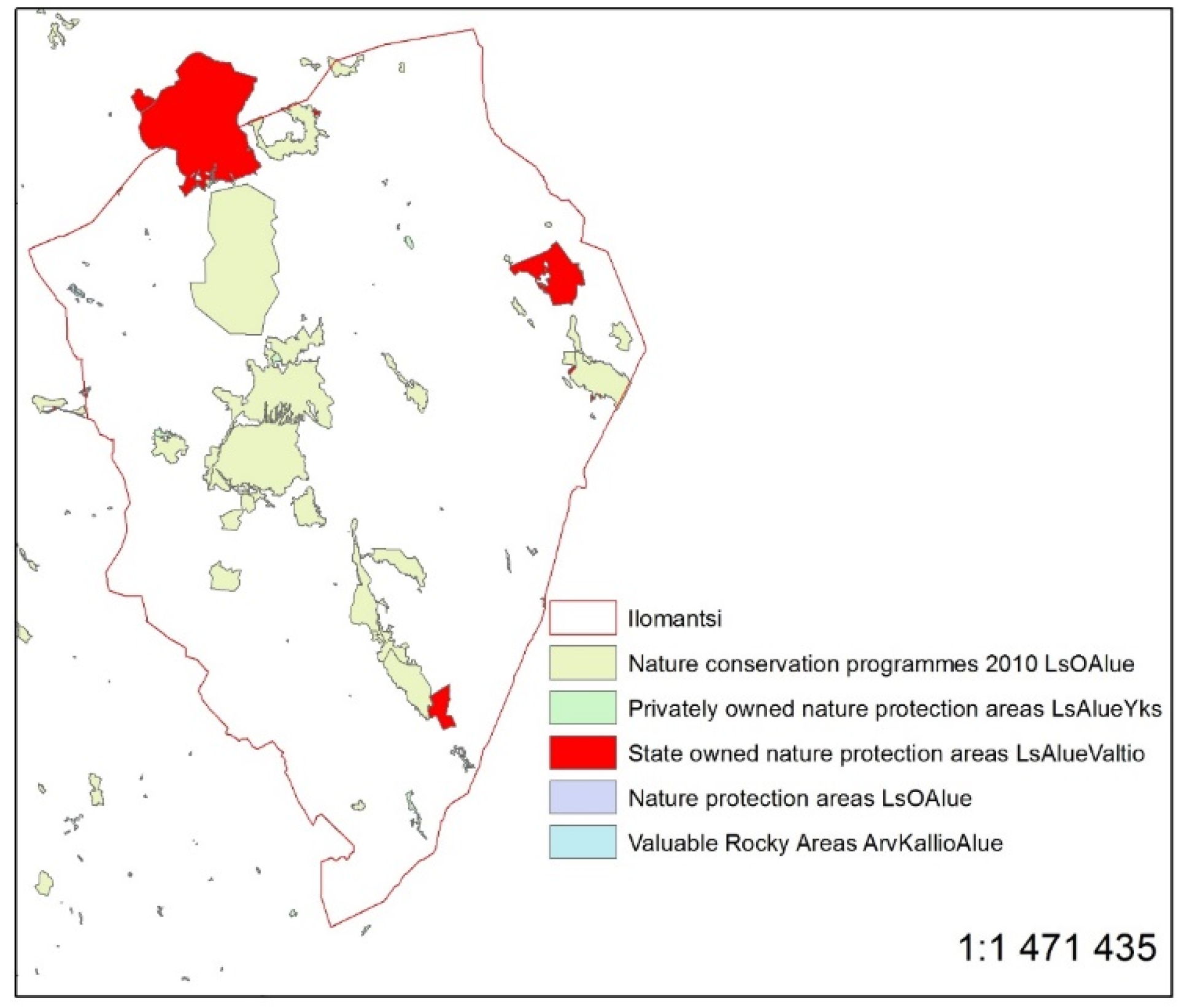
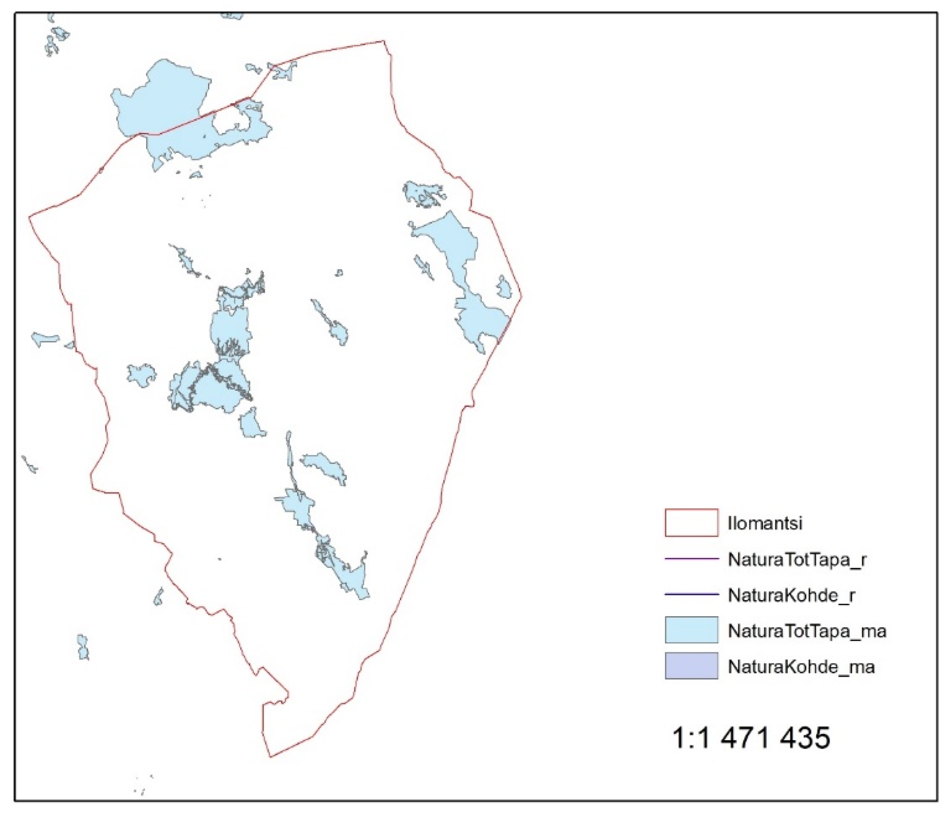
Examples of available corresponding GIS layers from the OIVA database for the Ilomantsi commune are presented in
Figure 2 and
Figure 3.
New forest road construction is rare in Finland since the majority of the forest area is already covered by intensive road networks. The roads can be detected automatically from high-resolution remote sensing data using image segmentation algorithms or by visual interpretation of medium resolution images (i.e., Landsat or Sentinel). Free high-resolution images are not yet available for large areas, so we used medium-resolution data combined with existing road networks in order to visually interpret the images. In cases where newly constructed roads cross-protected areas or valuable habitats or recreation areas, it was considered a violation of criteria implementation, where newly constructed roads did not cross those areas, the criteria was considered as implemented.
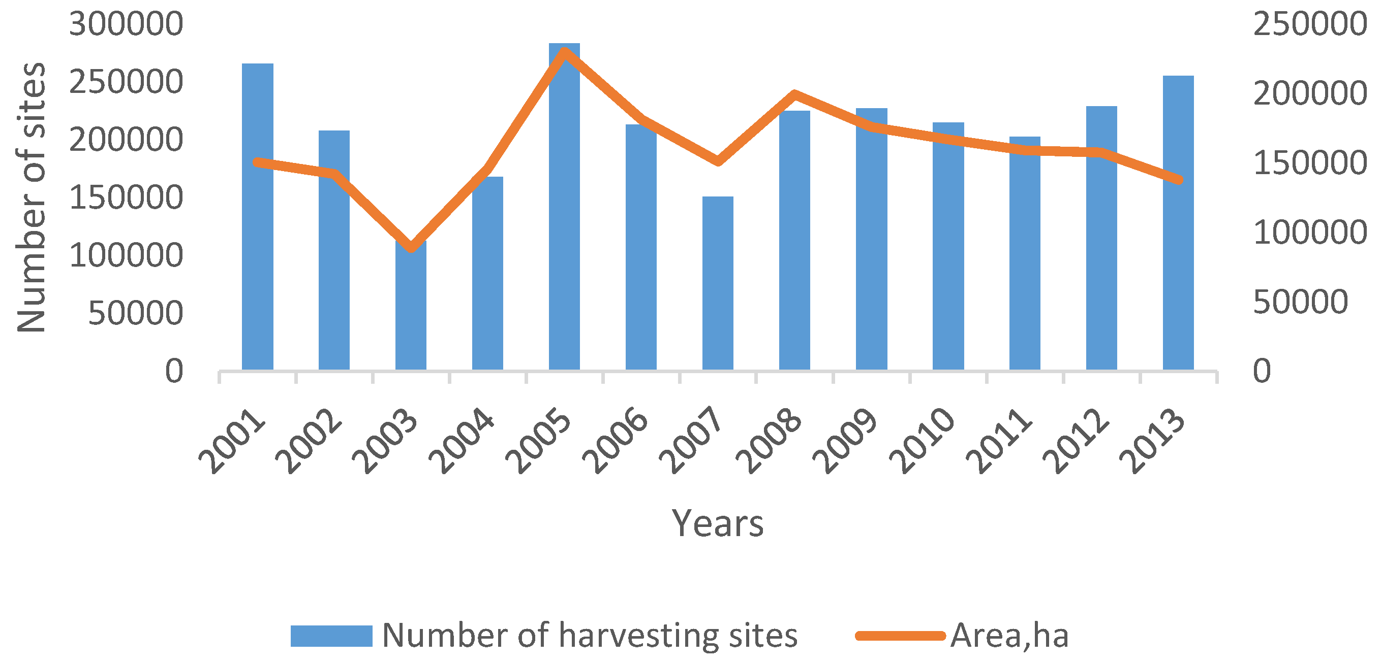
The results of the analysis of the online cloud-based remote sensing platform [
41] showed that, during the 2001–2013 period, a total of 2,756,159 forest sites were logged in Finland; on average, 212,013 sites per year. The total harvested area detected by remote sensing during the same period was 2,087,111 ha (
Figure 4). The average size of the harvesting area was 0.75 ha. Authors assumed based on interviews with experts in forest audits that 1% of all harvesting sites have to be checked during a PEFC audit, and that it requires an average 0.5 working days per harvesting site for field verification. Thus, we estimated that a total of 1060 person days per year would be spent on field verification. The information on the number of sites harvested annually and their average size is essential to understanding the workflow of field verification and the potential costs involved.
4. Discussion
Forest certification faces numerous challenges due to the remoteness, size, and variability of the forest resources. Evidence to support certification decisions is not always independent, as it is mainly provided by the forestry companies that are being certified. Forest certification schemes require tools to increase operational transparency and brand value as they expand globally very fast. Accredited certification bodies require independent spatial and forest management data for more targeted and cost-efficient inspections and stakeholder consultations. Forestry organizations require a more convenient means for the submission of data, small organizations would benefit from an improved certification process so that reliability is less dependent on forest size, and NGOs and other stakeholders require better insight into the on-ground details of certification.
If we assume that, under standard PEFC FI 1002:2014, all new harvesting sites and roads will be checked, this would require at least 106,007 person days per year. Clearly, this is not feasible from an economic point of view. Application of remote sensing-based audits of the most sensitive criteria and indicators could help to increase the transparency of forest certification and improve credibility of the PEFC system. The proposed method guarantees that the highly sensitive forest management operations will be partly traced.
While remote sensing-based indicator verification could be used during the audit, an analysis of data usage among stakeholders and certification bodies identified barriers to using the data. Firstly, there is a lack of knowledge in regard to the available data and to the procedures needed to extract valuable information from publicly available data. Secondly, the data are dispersed among many different places and servers on the internet. Much time is needed to collate the relevant information into one database. Thirdly, some valuable datasets are not publicly available (e.g., forest relics, high conservation value forests).
There is a critical need to obtain up-to-date spatial information of forest conditions and variability not only over long periods of time, but also at an operational level. The role of technological advancement is also quite relevant in this respect. Currently, there are restrictions in place that make the valuation process questionable: The area of the field audit is limited and the verification result is based on sampling; the evaluation of SFM indicators is based on the expertise of the auditor; and the actual conditions of large forest stands are not easy to determine. Modern spatial data analysis and GIS techniques, in combination with freely accessible remote sensing data, are a useful and important toolkit in assistance of the verification of SFM practices on the ground.
One of the limitations of the applied method in the study was the general assumption that the main disturbance from forestry is only from harvesting and that the proportion of forest fires is negligible. In this study, it was not possible with the current technique to distinguish harvesting sites and forest fires from interpreted images. The official forestry statistics indicates that an average 500–1500 ha of forest lands burn annually [
42]. Thus, forest fires account for 0.2%–0.7% of the total area of harvesting sites annually. However, a recent study has shown that the proportion of forest fires may increase by 10–40% in the coming decades due to climate change [
43]. Another limitation in this study was that it was not possible to identify harvesting sites smaller than 0.15 ha due to the resolution of images; however, over 90% of identified forest sites exceeded this size, so the applicability of the chosen Landsat images was very high.
The development of an independent freely accessible online GIS tool available to all interested parties that will allow for the verification of SFM based on PEFC requirements would fill these needs.
5. Conclusions
It was technically possible to evaluate 18% of the standard with RS-GIS with publicly available imagery. However, the six criteria mentioned in
Table 2 are the most complicated for reliable verification in the field and is usually based on a sampling approach;
i.e., only a small part (for example, 1%) of all harvesting sites will be visited during the audit.
From our experience as FSC and PEFC auditors, approximately 40 h are needed to evaluate the 57 indicators of the standard per certificate holder, and half of the time (20 h) is required to evaluate the six criteria since field verification is needed. Providing certification bodies with access to the automatic system for forest management assessment using the remote sensing data would save 20 h per audit, increase transparency of certification, cover 100% of the certified area, and allocate the most expensive resources of field audit to problematic areas. To improve the certification process, the data could be collected from public sources and interested parties and added to a cloud-based platform (e.g., online tool [
41]), which provides spatial data management and remote sensing data processing. Moreover, it is essential that training on the use of the service should be organized for stakeholders interested.
There is a need to develop an online tool for the evaluation of past and current forest management practice using remote sensing data. Any interested party in SFM and certification would be able to access the tool online and find relevant information for the implementation of certification schemes in real time, providing a broad understanding of their current status and future developments. It would also provide PEFC with a tool for verification of the compliance for geographically explicit criteria and indicators. These technological improvements will sufficiently address PEFC’s strategies for growth, market access and communication, governance and operations. The results of the data processing in the system can be used by auditing companies in Finland in order to increase the transparency of independent verifications and improve the cost-efficiency of the audit.
Acknowledgments
The work of Eugene Lopatin and Maxim Trishkin was funded by the Ministry of Education and Science of Russian Federation (Project id RFMEFI58615X0020, contract NO. 14.586.21.0020).
Author Contributions
E.L. and M.T. conceived and designed the experiments; M.T. performed the experiments; E.L. and M.T. analyzed the data; M.T. and E.L. wrote the paper; O.G. provided valuable comments to the paper.
Conflicts of Interest
The authors declare no conflict of interest. The founding sponsors had no role in the design of the study; in the collection, analyses, or interpretation of data; in the writing of the manuscript; or in the decision to publish the results.
Abbreviations
The following abbreviations are used in this manuscript:
| PEFC | Programme for the Endorsement of Forest Certification |
| RS-GIS | Remote Sensing Geographical Information Systems |
| FSC | Forest Stewardship Council |
| ELY | Centre for Economic Development, Transport and the Environment |
| SFM | Sustainable Forest Management |
| SYKE | Finnish Environment Institute |
References
- Jonsson, R.; Mustonen, M.; Lundmark, T.; Nordin, A.; Gerasimov, Y.; Granhus, A.; Hendrick, E.; Hynynen, J.; Kvist, J.; Kaliszewski, V.A.; et al. Conditions and Prospects for Increasing Forest Yield in Northern Europe. Metlan työraportteja/Working Papers of the Finnish Forest Research Institute 271. 41 s. ISBN 978-951-40-2424-5 (PDF). Available online: http://www.metla.fi/julkaisut/workingpapers/2013/mwp271.htm (accessed 10 October 2015).
- Finnish Forest Research Institute. Statistical Year Book of Forestry; Finnish Forest Research Institute: Vantaa, Finland, 2008. [Google Scholar]
- Auvinen, A.-P.; Kemppainen, E.; von Weissenberg, M. Fourth National Report on the Implementation of the Convention on Biological Diversity; The Finnish Environment 3/2010; Suomen Ympäristö: Helsinki, Finland, 2010. [Google Scholar]
- Pykälä, J.; Heikkinen, R.K.; Toivonen, H.; Jääskeläinen, K. Importance of forest act habitats for epiphytic lichens in Finnish managed forests. For. Ecol. Manag. 2006, 223, 84–94. [Google Scholar] [CrossRef]
- Raitio, K. “You Can’t Please Everyone”—Conflict Management Practices, Frames and Institutions in Finnish State Forest; Working Papers of Social Sciences; University of Joensuu: Joensuu, Finland, 2008. [Google Scholar]
- Paloniemi, R.; Varho, V. Changing ecological and cultural states and preferences of nature conservation policy: The case of nature values trade in South-Western Finland. J. Rural. Stud. 2009, 25, 87–97. [Google Scholar] [CrossRef]
- Peltola, T.; Tuomisaari, J. Re-inventing forestry expertise: Strategies for coping with biodiversity protection in Finland. For. Policy Econ. 2016, 62, 11–18. [Google Scholar] [CrossRef]
- Suopajärvi, T. Liukuvat metsäyhteisöt: Yhteisöllisyys metsäammattilaisten luonnonsuojelukertomuksissa. In Ympäristö ja kulttuuri; Kallinen, T., Nygren, A., Tammisto, T., Eds.; Working papers of Social Department; 11 University of Helsinki: Helsinki, Finland, 2012; pp. 83–106. [Google Scholar]
- Keskitalo, E.C.H.; Sandström, C.; Tysiachniouk, M.; Johansson, J. Local consequences of applying international norms: Differences in the application of forest certification in Northern Sweden, Northern Finland and Northwest Russia. Ecol. Soc. 2009, 14, 1. [Google Scholar]
- Seuring, S.; Müller, M. From a literature review to a conceptual framework for sustainable supply chain management. J. Clean. Prod. 2008, 16, 1699–1710. [Google Scholar] [CrossRef]
- Gulbrandsen, L.H. Overlapping public and private governance: Can forest certification fill the gaps in the global forest regime. Glob. Environ. Politics 2004, 4, 75–99. [Google Scholar] [CrossRef]
- Taiga rescue network. Newsletter on Boreal Forests “What Future for the Taiga?”; 1401-2405Taiga Rescue Network: Jokkmokk, Sweden, 2000; Issue 32. [Google Scholar]
- Johansson, J. Constructing and Contesting the Legitimacy of Private Forest Governance: The Case of Forest Certification in Sweden. Doctoral dissertation. Available online: http://www.dissertations.se/about/Johanna+Johansson/ (accessed on 6 October 2015).
- FSC Finland. FSC Numeroina. Available online: http://fi.fsc.org/ (accessed on 13 November 2015).
- Trishkin, M.; Lopatin, E. New Solutions to Increase the Wood Value Certification of the Ilomantsi Model Forest Using FSC Group Certification Approach. Available online: http://www.modelforest.fi/images/publications/new%20solutions%20to%20increase%20wood%20value_final.pdf (accessed on 15 October 2015).
- Cashore, B.; Auld, G.; Newsom, D. Forest certification (eco-labeling) programs and their policy-making authority: Explaining divergence among North American and European case studies. For. Policy Econ. 2002, 5, 225–247. [Google Scholar] [CrossRef]
- Kallas, A. Public forest policy making in post-Communist Estonia. For. Policy Econ. 2002, 4, 323–332. [Google Scholar] [CrossRef]
- Cashore, B.; van Kooten, G.C.; Vertinsky, I.; Auld, G.; Affolderback, J. Private or self-regulation? A comparative study of forest certification choices in Canada, the United States and Germany. For. Policy Econ. 2003, 7, 53–69. [Google Scholar] [CrossRef]
- Cashore, B.; Auld, G.; Newsom, D. Governing Through Markets: Forest Certification and the Emergence of Non-State Authority; Yale University Press: London, UK, 2004. [Google Scholar]
- Ozinga, S. Footprints in the Forest-Current Practice and Future Challenges in Forest Certification; Forests and the European Union Resource Network (FERN): Utrecht, Finland, 2004. [Google Scholar]
- Nebel, G.; Quevedo, L.; Jacobsen, J.B.; Helles, F. Development and economic significance of forest certification: the case of FSC in Bolivia. For. Policy Econ. 2005, 7, 175–186. [Google Scholar] [CrossRef]
- Newsom, D.; Bahm, V.; Cashore, B. Does forest certification matter? An analysis of operation-level changes required during the SmartWood certification process in the United States. For. Policy Econ. 2006, 9, 197–208. [Google Scholar] [CrossRef]
- Overdevest, C.; Rickenbach, M.G. Forest certification and institutional governance: an empirical study of forest stewardship council certificate holders in the United States. For. Policy Econ. 2006, 9, 93–102. [Google Scholar] [CrossRef]
- Araujo, M.; Kant, S.; Couto, L. Why Brazilian companies are certifying their forests? For. Policy Econ. 2008, 11, 579–585. [Google Scholar] [CrossRef]
- Cubbage, F.; Diaz, D.; Yapura, P.; Dube, F. Impacts of forest management certification in Argentina and Chile. For. Policy Econ. 2010, 12, 497–504. [Google Scholar] [CrossRef]
- Howard, P.H.; Allen, P. Beyond organic and fair trade? An analysis of ecolabel preferences in the United States. Rural. Sociol. 2010, 75, 244–269. [Google Scholar] [CrossRef]
- Masters, M.; Tikina, A.; Larson, B. Forest certification audit results as potential changes in forest management in Canada. For. Chron. 2010, 86, 455–460. [Google Scholar] [CrossRef]
- Cerutti, P.M.; Tacconi, L.; Nasi, R.; Lescuyer, G. Legal vs. certified timber: preliminary impacts of forest certification in Cameroon. For. Policy Econ. 2011, 13, 184–190. [Google Scholar] [CrossRef]
- Johansson, J.; Lidestav, G. Can voluntary standards regulate forestry?—Assessing the environmental impacts of forest certification in Sweden. For. Policy Econ. 2011, 13, 191–198. [Google Scholar] [CrossRef]
- Trishkin, M.; Lopatin, E.; Karjalainen, T. Assessment of motivation and attitudes of forest industry companies toward forest certification in northwestern Russia. Scand. J. For. Res. 2014, 29, 283–293. [Google Scholar] [CrossRef]
- Trishkin, M.; Lopatin, E.; Karjalainen, T. Exploratory assessment of a company’s due diligence system against the EU timber regulation: A case study from Northwestern Russia. Forests 2015, 6, 1380–1396. [Google Scholar] [CrossRef]
- Miteva, D.A.; Loucks, C.J.; Pattanayak, S.K. Social and environmental impacts of forest management certification in Indonesia. PLoS ONE 2015, 10, e0129675. [Google Scholar] [CrossRef] [PubMed]
- Maletz, O.; Tysiachniouk, M. The effect of expertise on the quality of forest standards implementation: The case of FSC forest certification in Russia. For. Policy Econ. 2009, 11, 422–428. [Google Scholar] [CrossRef]
- McDermott, C.L. Trust, legitimacy and power in forest certification: a case study of the FSC in British Columbia. Geoforum 2012, 43, 634–644. [Google Scholar] [CrossRef]
- Newman, J. Beyond the deliberative subject? Problems of theory, method and critique in the turn to emotion and affect. Crit. Policy Stud. 2012, 6, 465–479. [Google Scholar] [CrossRef]
- Transparent Forests. Satellite Remote Sensing to Strengthen Quality and Transparency. Available online: https://ic.fsc.org/transparent-forests.552.htm (accessed on 26 November 2015).
- PEFC FI 1002:2004. Available online: http: //www.pefc.fi/pages/fi/asiakirjat-ja-materiaalit/pefc-fi-2014--standardit.php (accessed on 23 September 2015).
- Metsähallitus. Available online: http://metsa.fi/sivustot/metsa/fi/Sivut/Etusivu.aspx (accessed on 22 September 2015).
- Frequently Asked Questions about the Landsat Missions. Available online: http://landsat.usgs.gov/band_designations_landsat_satellites.php (accessed on 26 September 2015).
- OIVA–Ympäristö-ja Paikkatietopalvelu Asiantuntijoille [OIVA–Environment and location services for experts]. Available online: http://wwwp2.ymparisto.fi/scripts/oiva.asp (accessed on 15 July 2015).
- Forestrycloud–Cloud Based Forest Management. Available online: http://www.forestrycloud.com/ (accessed on 8 July 2015).
- Kainulainen, A. Why There Is so Little Amount of Forest Fires in Finland? Available online: http://www.eramets.ee/life/images/stories/life/LIFE%2B_Conference_Anssi_Kainulainen.pdf (accessed on 3 February 2016).
- Lehtonen, I.; Ruosteenoja, K.; Venäläinen, A.; Gregow, H. The projected 21st century forest-fire risk in Finland under different greenhouse gas scenarios. Boreal Environ. Res. 2014, 19, 127–139. [Google Scholar]
© 2016 by the authors; licensee MDPI, Basel, Switzerland. This article is an open access article distributed under the terms and conditions of the Creative Commons by Attribution (CC-BY) license (http://creativecommons.org/licenses/by/4.0/).


