Abstract
This research proposes a green belt as a strategic response to urban expansion in Lomas del Paraíso, Villa María del Triunfo, Lima. Uncontrolled urban growth threatens the local ecosystem, exacerbates the lack of public spaces, and limits employment opportunities. The study employs an integrated methodology that includes urban, community, and especially environmental analysis. This involved the collection of climatic data, and the identification of local flora and fauna, supported by digital tools such as Google Earth, AutoCAD 2023, Revit, and 3D Sun-Path. The proposal incorporates urban, environmental, technological, and community-based design strategies grounded in permaculture principles, circular economy frameworks, and the Sustainable Development Goals (SDGs). These approaches emphasize the symbiotic relationship between the community and the Lomas ecosystem. The feasibility and potential impact of the proposed green belt were compared with similar case studies, such as Medellín’s metropolitan green belt (Jardín Circunvalar) and the Arví Ecotourism Park. These benchmarks highlight the relevance of community involvement and user awareness in ecological preservation. In conclusion, implementing a green belt in Lomas del Paraíso would not only curb unregulated urban sprawl but also enhance community–nature connectivity and promote sustainable development through integrated environmental, social, and urban strategies.
1. Introduction
The diversity of ecosystems worldwide is essential for maintaining global ecological and climatic balance [1]. From vast tropical rainforests to fragile coastal mangroves, these diverse environments host high levels of biological diversity and provide vital ecosystem services. Their importance lies in the provision of food, water, and natural resources, as well as in climate regulation, crop pollination, and natural disaster mitigation [2]. Ecosystems are dynamic communities in which living organisms interact with abiotic factors, such as water, light, and soil, through biological, chemical, and physical processes fundamental to sustaining life. They are typically classified as terrestrial, freshwater, and marine ecosystems, each characterized by unique structures and biodiversity. However, their complexity surpasses these broad categories, as each biome contains multiple interconnected ecosystems. Recent studies have identified more than 430 terrestrial and 37 marine ecosystem types, underscoring the immense diversity and the challenge of defining clear boundaries between them (Figure 1) [3].
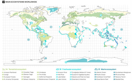
Figure 1.
Global map of key ecosystem diversity: terrestrial, freshwater, and marine.
Moreover, ecosystems serve as inexhaustible sources of scientific and cultural knowledge. Therefore, their conservation and sustainable management are essential to preserving planetary health, enhancing resilience to environmental challenges, and ensuring a lasting balance between nature and human communities [4].
Peru stands out as one of the countries with the greatest ecosystem diversity in the world, hosting a wide range of landscapes. The Peruvian Amazon, part of the planet’s green lung, is home to an extensive variety of flora, fauna, and microorganisms, many of which are endemic and unique to their species. The Peruvian Andes, with their páramo ecosystems and cloud forests, provide distinctive habitats for species adapted to extreme high-altitude conditions. Along the coast, deserts, wetlands, and lomas (fog oases) create a mosaic of environments that contribute significantly to global biological richness [5,6].
Within this wide range of ecosystems, some have been classified as “fragile ecosystems,” which are natural environments that exhibit a marked susceptibility to environmental disturbances, whether due to climatic, geological, or anthropogenic factors. These ecosystems tend to have a balanced structure and are highly sensitive to significant changes in their surroundings [7]. At the national level, according to the Ministry of Agriculture and Irrigation (MINAGRI), 11 fragile ecosystems have been officially recognized, 10 of which are located in the Lima region (Figure 2). These include the Lomas of Lúcumo, Lurín, Pachacamac, Paloma, Pacta, Villa María del Triunfo, Retamal, Amancaes, Manchay, and Carabayllo, as well as the Paca Lagoon in the Junín region [8].
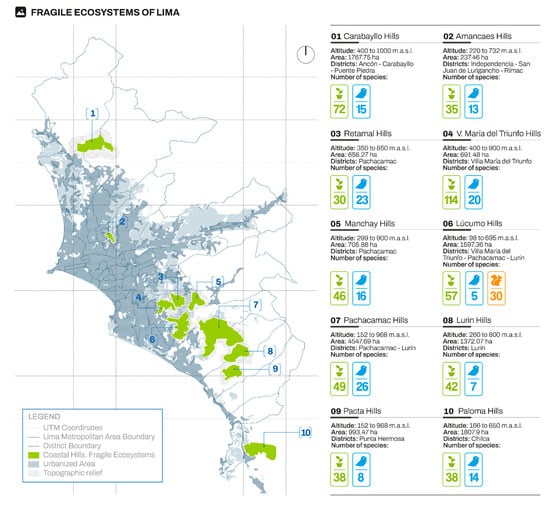
Figure 2.
Map of coastal Lomas classified as fragile ecosystems in Lima.
The fragile ecosystems of Lima face various threats that endanger their biodiversity and ecological functions. Among the main factors contributing to their degradation are uncontrolled urban expansion, which reduces and fragments their territory, as well as illegal mining and vegetation clearing, which disrupt their ecological balance. Additionally, pollution from solid waste and unregulated tourism have negative impacts on their flora and fauna. Some lomas, such as Lúcumo and Amancaes, have implemented conservation strategies, while others, such as Paloma, Pacta, and Manchay, still lack significant protection measures (Table 1), highlighting the urgent need to implement sustainable management plans and conservation policies [9,10].

Table 1.
Comparative overview of the current status of fragile ecosystems in Lima.
The conservation of fragile ecosystems is essential due to their high susceptibility, which can lead to devastating consequences for biodiversity and ecosystem services. These environments, being under environmental and human pressures, require effective strategies that minimize negative impacts and foster resilience [11]. The implementation of green corridors emerges as a strategy to strengthen this preservation. These corridors, which are natural connections between habitats, facilitate the movement of species and the restoration of fragmented landscapes. Establishing green corridors in areas with fragile ecosystems promotes resilience and adaptation to climate change and other threats, ensuring the continuity of biological diversity and long-term sustainability. Moreover, these corridors provide additional benefits, such as improving air quality, mitigating climate change, and enhancing human well-being by creating accessible green spaces [12].
An example of such spaces is the metropolitan green belt—Jardín Circunvalar de Medellín, described as “a large open-air classroom,” which incorporates strategies and principles such as controlled urban expansion with a comprehensive development vision; dignified, safe, sustainable, and accessible housing; inclusive public spaces as territorial structuring elements; integral territorial sustainability; and territorial connectivity with quality (Figure 3A) [13].
Another example of a space that applies conservation and sustainable development strategies is Parque Arví in Antioquia, a natural reserve that combines environmental protection with recreation and ecotourism. This park is a reference point for the preservation of high Andean Forest ecosystems and for the integration of local communities through sustainable tourism projects. Its strategies include biodiversity conservation, responsible management of natural resources, and the generation of economic opportunities for the local population through ecotourism and educational activities (Figure 3B) [14]. In addition, scientific works such as “Islands in the Fog: A Systematic Review of the Coastal Lomas of South America” highlight the climatic variability of these fragile ecosystems and their unique microclimate, which plays a crucial role in maintaining species [15].
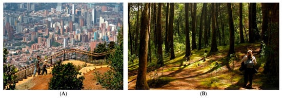
Figure 3.
(A) Jardín Circunvalar de Medellín, reprinted with permission from Ref. [16]; (B) Arví Ecotourism Park, reprinted with permission from Ref. [17].
The three case studies, the metropolitan green belt “Jardín Circunvalar de Medellín,” the Arví Ecotourism Park, and the research on South American coastal fog oases titled “Islands in the Mist: A Systematic Review of South American Coastal Lomas”, share a common focus on ecological conservation and sustainable development, albeit in different contexts. While the first two, located in Colombia, aim to protect ecosystems through territorial management and ecotourism, the coastal lomas of Peru and Chile are notable for their reliance on fog as a primary moisture source and their heightened vulnerability to climate change. Collectively, these examples highlight the importance of comprehensive strategies that integrate environmental conservation, community participation, and sustainable development in order to enhance ecosystem resilience in the face of current threats.
As shown in Table 2, this comparative table highlights the diverse approaches to conservation and sustainable development across different ecological and territorial contexts. While the metropolitan green belt in Medellín operates on a metropolitan scale and integrates urban containment with social housing and public space provision, Arví Ecotourism Park adopts a regional model that links environmental protection with community-based tourism and education. In contrast, Islands in the Mist serves as a scientific reference that documents the ecological fragility and climatic sensitivity of fog-dependent ecosystems, emphasizing the critical role of fog dynamics and El Niño-Southern Oscillation (ENSO) patterns in the survival of lomas habitats. The three cases differ not only in scale and scope, but also in the degree of community participation and institutional involvement, revealing the importance of governance structures in ensuring long-term sustainability. Importantly, while the Medellín and Arví projects involve formal institutions and significant public investment, the scientific review underscores the limited inclusion of local communities, calling for more participatory frameworks. From a replicability perspective, the Medellín model offers valuable lessons in urban integration, whereas Arví demonstrates how ecotourism can become a viable conservation tool. The Islands in the Mist study, though primarily academic, provides a crucial foundation for understanding fog ecosystems under climate stress.

Table 2.
Comparison of key characteristics of international conservation strategies in varied ecosystem types.
Among the 67 coastal lomas (fog oases) found in Peru, 19 are located in Lima. These areas, such as the Lomas de Lúcumo, Lurín, Pachacamac, and others, are notable for their flora and fauna adapted to arid and semi-arid conditions. Their importance lies in their ability to capture fog, provide specific habitats for various species, and contribute to water regulation. Within the lomas of Villa María del Triunfo is the Lomas del Paraíso, located in southern Lima—a valuable and delicate ecosystem. Socially, these areas are important to the local community and serve as venues for various outreach activities [18].
From an economic perspective, these lomas are a tourist attraction due to their unique biodiversity, particularly through the Lomas del Paraíso Ecotourism Circuit. This highlights their potential to boost the local economy through guided tours and visits focused on environmental education and the preservation of lomas as fragile ecosystems. Ecologically, this system features a humid microclimate that supports endemic species such as the Flor de Amancaes. Its ecological, economic, and social potential makes it an ideal case study for understanding how these ecosystems can be conserved and sustainably utilized [19].
Currently, there is clear interest in preserving the lomas, especially through the efforts of the Asociación Circuito Ecoturístico Lomas de Paraíso. This association promotes the conservation of the ecosystem by raising awareness of its importance and aims to involve the community in conservation initiatives through participation in ecological and cultural activities [20]. The active participation of volunteer teams plays an invaluable role in environmental education and loma preservation. In this context, meaningfully integrating them into the proposed project will be essential (Figure 4).
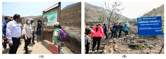
Figure 4.
(A) Visit by authorities to the “Lomas del Paraíso,” reprinted with permission from Ref. [21]; (B) guided tour led by volunteers from the Lomas del Paraíso Ecotourism Circuit Association, reprinted with permission from Ref. [22].
The periodic variations experienced by flora throughout the seasons of the year can manifest as seasonal adaptations, such as flowering and fruiting in response to changing climatic conditions. During different seasons, plant species may exhibit physiological and compositional changes influenced by factors such as temperature, sunlight, and water availability. These seasonal changes not only impact the visual appearance of the lomas but also play a crucial role in ecosystem dynamics, affecting interactions between plants and other environmental components [23,24].
However, informal urban expansion over the past 20 years in Metropolitan Lima, particularly in areas near the Lomas del Paraíso in Villa María del Triunfo, has led to encroachment into buffer zones of the lomas, thereby reducing areas of endemic flora. This phenomenon has negatively impacted fauna development and increased ecosystem vulnerability [23,25].
Figure 5 illustrates how, in recent years, the Lomas of Villa María del Triunfo have undergone an accelerated process of degradation due to uncontrolled urban expansion, indiscriminate vegetation clearing, and the increase in informal settlements. The progressive invasion of these natural areas has significantly reduced vegetation cover, affecting biodiversity and altering the fragile ecosystems that depend on fog moisture [26,27]. In addition, soil extraction and the conversion of green areas into construction sites have weakened the lomas’ capacity to function as carbon sinks and local climate regulators. This is compounded by pollution from the dumping of solid waste and construction debris, which has further deteriorated the landscape and soil quality. Despite efforts by environmental collectives and organizations to restore and protect these areas, the lack of effective regulation and long-term conservation plans has allowed degradation to persist, putting at risk the ecological balance of the lomas and the well-being of nearby communities [28].
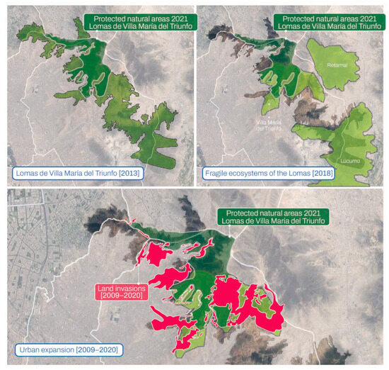
Figure 5.
Degradation map of the Lomas of Villa María del Triunfo.
The issues in the Lomas del Paraíso can be analyzed through two main axes: uncontrolled urban expansion and a threatened ecosystem, as well as a lack of public spaces and job opportunities. The high demand for housing in the Lima Metropolitan Area has driven accelerated urban growth toward peripheral zones, such as the district of Villa María del Triunfo (VMT). This phenomenon has particularly affected the Lomas del Paraíso, where disorganized urbanization has led to biodiversity loss and the alteration of the natural landscape. Deforestation and soil degradation have reduced the area’s capacity to sequester carbon and regulate air quality, contributing to increased pollution and local warming.
Beyond the environmental impact, the lack of public spaces and economic opportunities limits community development. In the area near Lomas del Paraíso, the absence of adequate infrastructure hinders the creation of a sustainable local economy. The lack of commercial establishments, such as markets or community fairs, restricts access to stable employment, leaving many residents without consistent sources of income. This situation exacerbates the socioeconomic vulnerability of the population and reinforces dependence on informal labor sectors [29].
Moreover, the progressive reduction in public spaces in VMT negatively affects residents’ quality of life. According to the World Health Organization (WHO), the recommended amount of green space per person is 8 m2; however, in the case of Villa María del Triunfo, the National Environmental Information System (SINIA) reports only 0.37 m2 of green space per inhabitant. This severely limits opportunities for recreation, leisure, and social interaction [30]. Nonetheless, recent years have seen a growing interest in revitalizing these natural spaces, particularly among young people and members of the Lomas del Paraíso Association. This organization has actively promoted ecosystem conservation and has encouraged community involvement through various activities within the lomas circuit. However, it remains necessary to strengthen this initiative by establishing more areas dedicated to environmental education and community workshops that foster active participation in territorial protection.
The situation of Lomas del Paraíso underscores the need to integrate land use planning strategies, environmental conservation, and social development. It is essential to implement measures to curb urban expansion in these ecologically valuable zones, promote sustainable housing solutions, and ensure proper urban planning. Likewise, the creation of functional public spaces and job opportunities can enhance residents’ quality of life, ensuring a balance between urban growth and the preservation of the natural environment.
After identifying the issues, the following problem formulation is proposed:
- To what extent does ecological restoration using native vegetation contribute to countering urban sprawl in Lomas del Paraíso?
- To what extent does community participation contribute to countering urban sprawl in Lomas del Paraíso?
- To what extent does the use of sustainable technologies such as fog catchers contribute to countering urban sprawl in Lomas del Paraíso?
This study also aims to resolve these through the following objectives:
- To determine the extent to which ecological restoration using native vegetation contributes to counteracting urban sprawl in Lomas del Paraíso.
- To determine the extent to which community participation contributes to counteracting urban sprawl in Lomas del Paraíso.
- To determine the extent to which the use of sustainable technologies such as fog catchers contributes to counteracting urban sprawl in Lomas del Paraíso.
Therefore, this research aims to propose a green belt strategy in response to urban expansion in Lomas del Paraíso, with the goal of raising awareness about the importance of the lomas in Lima, Peru, in the year 2024.
2. Materials and Methods
2.1. Methodological Scheme
This research is non-experimental in nature and was organized into five phases: literature review, data collection, proposal development, discussion, and conclusions. Initially, green belt strategies applied in vulnerable urban contexts were identified through the analysis of academic studies, institutional reports, and local experiences in Lima. This review enabled the characterization of fragile ecosystems and the establishment of design criteria applicable to the case study.
Subsequently, a site analysis of Lomas del Paraíso was conducted, gathering climatic, environmental, topographic, and socio-economic data from official sources such as SENAMHI (Servicio Nacional de Meteorología e Hidrología del Perú, Lima, Peru), MINAM (Ministerio del Ambiente, Lima, Peru), and local universities. This process resulted in a comprehensive territorial diagnosis.
Based on the information collected, a green corridor proposal was developed that integrates principles of permaculture, circular economy, and community development, drawing on international references such as the Jardín Circunvalar in Medellín and Parque Arví. The proposal was evaluated in terms of feasibility and impact by comparing it to reference cases, taking into account social, environmental, and climatic factors. Finally, conclusions were established based on scientific literature and comparative studies, which allowed for the validation of the proposed approach for the Lomas del Paraíso case (Figure 6).
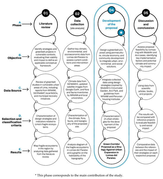
Figure 6.
Diagrams of the research stages.
Stakeholder Analysis
Stakeholder analysis is a tool used to understand the social and political complexity surrounding vulnerable urban ecosystems, such as Lomas del Paraíso. Given the increasing pressure from urban development, landscape fragmentation, and limited coordinated management, it is essential to identify the various stakeholders involved, their interests, levels of influence, positions, and capacities for collaboration. This understanding not only helps to reveal potential conflicts or alliances but also guides participatory conservation strategies, fosters shared responsibility in land management, and supports the design of more effective and sustainable long-term interventions [31].
Figure 7 presents the stakeholder analysis, which identified and classified the main groups and institutions that have a direct or indirect impact on the conservation and management of the Lomas del Paraíso ecosystem in Metropolitan Lima. Among these are institutional stakeholders such as the Municipality of Villa María del Triunfo, the Ministry of the Environment (MINAM), and the National Service of Natural Areas Protected by the State (SERNANP- Servicio Nacional de Áreas Naturales Protegidas por el Estado, Lima, Peru), which have high influence over the territory and, for the most part, hold a favorable position toward conservation. At the community level, the local population and youth organizations stand out, as their participation and sense of ownership are essential for ecosystem protection. The Asociación Circuito Ecoturístico Lomas del Paraíso was also identified as a key stakeholder, acting as a coordinator of community efforts and a promoter of sustainable activities such as ecotourism and environmental education.
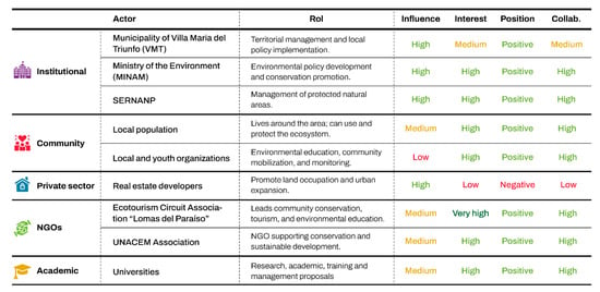
Figure 7.
Stakeholder analysis “Lomas del Paraíso”.
On the other hand, the analysis revealed the presence of stakeholders with opposing interests, such as real estate developers, who exert high influence but hold a negative stance toward conservation, posing a latent threat to the area’s sustainability. Stakeholders from the academic and NGO sectors, such as universities and the UNACEM Association, were also identified. Though their level of influence is moderate, they offer strong potential for positive collaboration. This analysis helps to understand the diversity of interests and power levels among stakeholders, facilitating the design of collaborative governance strategies that strengthen local capacities and reduce land use conflicts.
2.2. Territory
2.2.1. Study Area Location
Lomas del Paraíso is located in the district of Villa María del Triunfo, in the southern part of Lima, the capital city of Peru. This ecosystem forms part of the Pacific coastal desert and belongs to the Lomas ecosystem, which is characterized by seasonal vegetation that thrives primarily during the humid months due to the presence of coastal fog. The area comprises natural hillsides with endemic flora and fauna, urban expansion zones, and spaces of community interest owing to their ecological, educational, and recreational value. Lomas del Paraíso has emerged as a focal point for local conservation efforts and environmental education initiatives. Geographically, it is situated at approximately a latitude of −12.156747 and longitude of −76.930913.
Figure 8 presents a multiscale representation of the study area located in the Lomas of Villa María del Triunfo (VMT), highlighting its position within Metropolitan Lima and, at the district level, its insertion into a dense urban matrix. The main map illustrates the overlap of various protected zones recognized by ministerial resolutions, such as the extension of Loma VMT and Loma Retamal, as well as their inclusion within the Regional Conservation Area Lomas de Lima, demonstrating their ecological significance. However, adjacent urban areas are also identified, reflecting intense anthropogenic pressure on this fragile ecosystem. The presence of the Lomas del Paraíso Ecotourism Circuit suggests opportunities for sustainable land use, although its development requires coordinated and multiscale management, particularly given the proximity of the district boundary between VMT and Pachacámac.
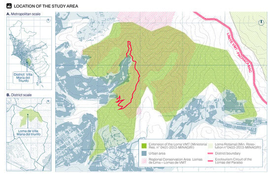
Figure 8.
Location of study area.
2.2.2. Topography
The topographic characterization of the study area allows for an understanding of terrain morphology, including its slopes, elevations, and potential physical constraints. This analysis was conducted using data obtained through geographic information systems (GIS) data from ArcGIS (Esri, Redlands, CA, USA, high-resolution satellite imagery, and contour lines generated from digital elevation models (DEMs) from USGS (United States Geological Survey, Reston, VA, USA) with suitable accuracy for both urban and natural contexts.
As shown in Figure 9, the topographic analysis enabled a more precise delineation of the most suitable areas for the implementation of the green belt, prioritizing sectors with moderate slopes that facilitate vegetation stabilization, community accessibility, and runoff management. Critical areas with steep slopes prone to erosive processes were identified, where the application of natural containment strategies will be necessary through revegetation with native species adapted to inclined soils.
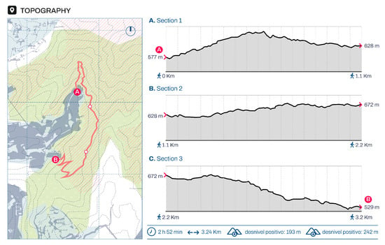
Figure 9.
Topographic analysis of the “Lomas del Paraíso” ecotourism circuit.
Furthermore, the topographic component was essential in defining zoning criteria and prioritization of land use within the green belt, distinguishing areas for strict conservation, ecological restoration, and controlled community use. The detailed understanding of the terrain also contributed to the identification of potential routes for the proposed ecotourism circuit, ensuring safe and sustainable pathways without compromising the integrity of the ecosystem. In this way, topography is not only a technical input but also a strategic tool for the landscape, ecological, and social design of the green belt in Lomas del Paraíso.
2.3. Climate Analysis
The climatic context of Lomas del Paraíso, located in the southern zone of Metropolitan Lima, falls within a subtropical arid climate, characterized by low annual precipitation and the marked influence of the Humboldt Current. Despite its location within the Peruvian coastal desert, this temporary ecosystem presents a climatic exception during the winter months, when atmospheric humidity increases significantly due to the presence of coastal fog (locally known as camanchaca). This interaction between arid climate and condensation phenomena allows for the emergence of the lomas ecosystem, whose existence depends directly on these specific atmospheric conditions.
Figure 10 illustrates key climatic characteristics of the region. The annual average temperature in this area ranges between 15 °C and 22 °C. During the summer months (December to March), temperatures reach their highest levels, with maximum values exceeding 26 °C, while in winter (June to September) they can drop to around 13 °C. This moderate thermal amplitude, influenced by the proximity to the sea, plays a critical role in shaping the biological activity and phenological cycles of the species inhabiting the Lomas. The rise in temperature during summer coincides with the loss of vegetation cover, highlighting the strong correlation between the thermal regime and the seasonal dynamics of this ecosystem.
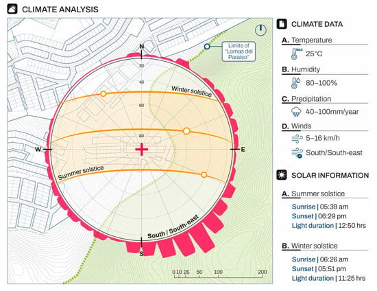
Figure 10.
Climatic analysis of Lomas del Paraíso.
Regarding humidity, a dual behavior is observed: in summer, relative humidity levels decrease to below 70%, whereas in winter they peak above 90%. This high winter atmospheric humidity is a key factor for the condensation of water in the form of fog (camanchaca), which partially compensates for the absence of effective rainfall. Rainfall is extremely scarce, with annual averages not exceeding 20 mm, making fog-derived moisture a vital alternative source for the temporary sustenance of vegetation.
The predominant winds originate from the southwest, with moderate intensity, and influence the formation and movement of fog masses. The interaction between topography and wind direction favors the accumulation of moisture on certain slopes facing the ocean. In terms of solar radiation, during the summer solstice (21 December), the solar path is higher and longer, intensifying evapotranspiration and direct insolation. In contrast, during the winter solstice (21 June), the solar angle decreases, days are shorter, and solar radiation is reduced, creating optimal conditions for fog condensation. This seasonal solar variation is decisive for the alternation between the ecological activation and dormancy of the lomas ecosystem [32].
2.3.1. Seasonality and Annual Dynamics
The ecosystem of Lomas del Paraíso exhibits pronounced seasonality, with a clearly defined annual cycle that alternates between an active (humid) phase and a dormant (dry) phase. This dual dynamic is driven not only by climatic factors such as humidity and temperature but also by topographic conditions and solar exposure. During the winter months (June to September), climatic conditions generate an environment of high humidity and low direct solar radiation, which enables the germination and growth of herbaceous and shrub species. In contrast, during the summer months (December to March), the ecosystem enters a dormant phase, during which vegetation cover nearly disappears, reducing the landscape to its bare geological features.
Figure 11 illustrates the phases of the annual cycle of Lomas del Paraíso. The humid phase is characterized not only by the presence of vegetation, but also by intense ecological activity: flowering, pollination, the emergence of insects and migratory birds, and seed dispersal processes. This short temporal window of four to five months constitutes the functional core of the ecosystem, and its preservation directly depends on the continuity and intensity of the fog phenomenon. Any alteration in seasonal climate patterns, such as those caused by ENSO events, can drastically reduce the duration or intensity of this active phase, affecting the regeneration of key species.
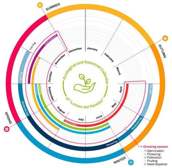
Figure 11.
Phases of the annual cycle of Flora in Lomas del Paraíso.
During the dry phase, although seemingly inert, the lomas maintain a state of ecological resistance. Seeds, bulbs, and root structures remain dormant, waiting for suitable conditions to reactivate. This resilience capacity has evolved as an adaptation to an extremely variable environment, where survival depends on precise synchronization with climatic cycles. Thus, the seasonality of Lomas del Paraíso not only organizes the temporality of the landscape but also structures the fundamental ecological processes that ensure its continuity year after year.
This seasonal alternation is not uniform across the lomas territory. Slopes facing southwest, which receive more fog due to marine winds, exhibit more prolonged vegetation development. In contrast, north- and east-facing slopes, more exposed to sunlight and with lower humidity capture, show delayed recovery and more limited vegetation cover. This creates a spatially uneven dynamic that must be considered in any conservation, management, or tourism activation strategy for the area [33,34,35].
2.3.2. Fog and Camanchaca
The coastal fog, locally known as camanchaca, is the main source of water for Lomas del Paraíso, compensating for the near-total absence of rainfall. This phenomenon occurs when humid air from the Pacific Ocean, driven by southwest winds, encounters cold air masses generated by the Humboldt Current, causing the moisture to condense into low fog. As the camanchaca ascends the loma slopes, it condenses on leaf surfaces, soil, and rocks, allowing for dripping or runoff that temporarily nourishes the ecosystem.
This is not only a climatic phenomenon but also one strongly dependent on topography. Lomas located between 300 and 800 m above sea level are especially favored, coinciding with the zone of maximum fog condensation. Variations in fog frequency and intensity are associated with larger atmospheric cycles such as El Niño and La Niña, directly affecting the biological productivity of the lomas. Therefore, fog monitoring is essential for understanding the future viability of the ecosystem under climate change scenarios [36].
The study of camanchaca in Lomas del Paraíso has gained importance in recent years, not only from an ecological standpoint but also from the perspectives of engineering and sustainable design. Experiments with fog catchers have demonstrated the potential to collect between 1 and 5 L of water per square meter per day, highlighting the hydrological potential of this phenomenon. This alternative has inspired proposals for green infrastructure and adaptive technologies that can support both ecosystem conservation and the water supply needs of nearby communities.
Additionally, camanchaca fulfills a symbolic and landscape role. The appearance of fog transforms the sensory perception of the landscape, introducing elements of mystery, silence, and calm that influence the visitor’s experience [37]. This sensory dimension should also be considered in proposals for public use or sustainable tourism in the area. Overall, camanchaca is not only a key climatic vector but also a cultural, scenic, and strategic resource for designing interventions aimed at enhancing the value of the lomas.
2.4. Flora and Fauna Analysis
Lomas del Paraíso represents a unique ecosystem where biodiversity thrives due to the interplay between topography, seasonal atmospheric humidity, and the evolutionary adaptations of its species. This ecosystem depends almost exclusively on camanchaca, a coastal fog that condenses on slopes facing the ocean and provides the necessary moisture for the germination, flowering, and development of a rich diversity of species. Despite its seasonal productivity, the lomas are facing progressive degradation caused by informal urbanization, overgrazing, indiscriminate harvesting, and the lack of effective conservation policies. This section presents a comprehensive analysis of the flora and fauna, not only in terms of composition, but also through their ecological roles, interdependencies, and dynamics shaped by the specific climatic conditions of the site.
As shown in Figure 12, the flora of the Lomas del Paraíso consists of a combination of herbaceous, shrub, cactus, climbing, and tree species, many of which are endemic or have a distribution restricted to the lomas ecosystems. Among these, Ismene amancaes, a symbolic species of Lima’s flora, stands out, as well as tree species such as Caesalpinia spinosa (tara) and Vachellia macracantha (aromo), which play important roles in nitrogen fixation, soil coverage, and providing shelter for fauna.
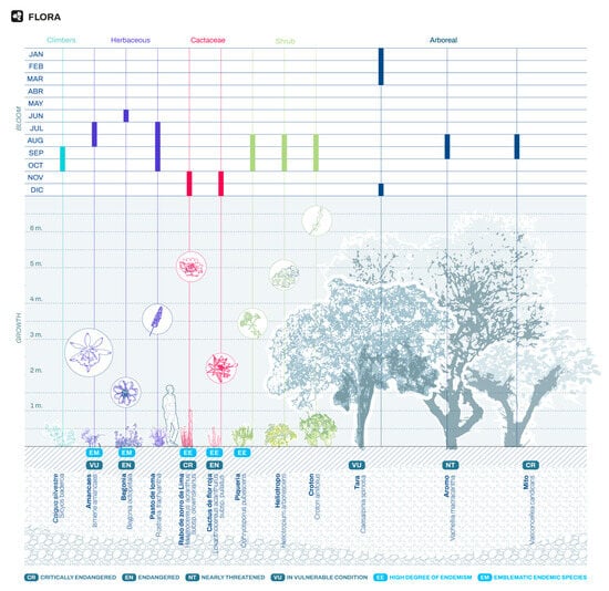
Figure 12.
Documented plant species in the Lomas.
A key feature of this vegetation is its strong synchrony with the seasonal humidity dynamics: the phases of germination, flowering, pollination, and seed dispersal are highly concentrated between June and October, when fog enables vegetative development [38,39]. During the rest of the year, much of the flora enters a state of dormancy, rendering the landscape visually desert-like. This cycle not only defines the ecosystem’s appearance but also its regenerative capacity.
However, pioneer and opportunistic species have been gradually displaced due to habitat fragmentation and soil compaction, preventing the natural recolonization of many lomas. In addition to their ecological value, several of these species possess medicinal, ornamental, or nutritional potential, yet unmanaged harvesting has contributed to the loss of reproductive individuals and the degradation of the seed bank. The progressive disappearance of vegetative cover has weakened the ecosystem’s capacity to capture moisture through condensation, thereby closing a feedback loop that jeopardizes the ecological balance of the lomas [40].
As shown in Figure 13, the faunal assemblage of the Lomas del Paraíso exhibits modest diversity, comprising birds, small mammals, insects, reptiles, and arachnids that have adapted to the semi-desert environment through specialized strategies in mobility, diet, and reproduction. Noteworthy among these are bird species such as the cactus canastero (Pseudasthenes cactorum) and the burrowing owl (Athene cunicularia), which find shelter and food exclusively during the humid season [41].
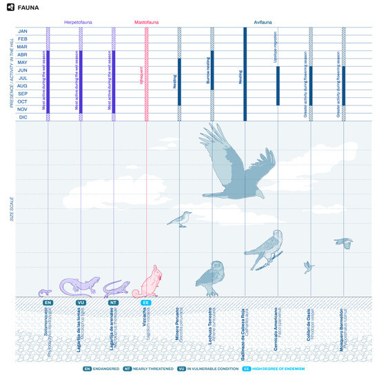
Figure 13.
Documented faunal assemblage in the Lomas Ecosystem.
The relationship between flora and fauna is highly symbiotic. Entomophilous pollination, important for the reproductive success of many herbaceous and shrubby plants, is facilitated by bees and butterflies that become active only under adequate humidity conditions. Similarly, seed dispersal of various species is aided by frugivorous birds and rodents, whose populations have declined due to urban pressure and the loss of structural vegetation.
A significant ecological phenomenon is the seasonality of faunal behavior. Many species become inactive or migrate during the dry season, making the fog season not only a period of peak plant reproduction, but also a time of heightened ecological activity within the trophic web. This pattern highlights the strong functional dependence of the fauna on the microclimate generated by coastal fog.
Regrettably, the fauna of the Lomas has been less studied than its flora, and its presence is under serious threat due to ecosystem fragmentation, the introduction of domestic species, and pollution. Habitat loss has led to reduced population sizes and altered behavioral patterns, generating an ecological imbalance that could become irreversible unless urgent conservation measures are implemented.
2.5. Hypothesis
This research is based on the recognition of a critical urban-environmental conflict: informal urban expansion, which threatens fragile ecosystems such as Lomas del Paraíso, located in the southern area of Metropolitan Lima. This phenomenon has generated a drastic reduction in vegetation cover, ecological fragmentation, loss of biodiversity, and the degradation of key ecosystem services such as fog capture, microclimate regulation, and the generation of socio-territorial opportunities for the local population. Given this scenario, the design and implementation of a green belt with a focus on sustainability is proposed as an alternative to mitigate these impacts and restore the relationship between community and natural environment.
From this, the following general hypothesis is raised:
- The implementation of a green belt based on permaculture principles, a circular economy, and sustainable community strategies significantly mitigates the effects of urban sprawl and contributes to the conservation of the fog ecosystem in Lomas del Paraíso, Lima, Peru.
This hypothesis is based on a systemic and integrative approach, combining ecological variables (such as revegetation with native species, water capture, and microclimate improvement), urban variables (delimitation of the expansion boundary and provision of public spaces), and social variables (active community participation, environmental education, and land ownership).
In addition, the following specific hypotheses are formulated, derived from the project’s core dimensions:
- H1: Ecological restoration using native vegetation adapted to fog ecosystems significantly contributes to reducing fragmentation and increasing ecosystem resilience.
- H2: Community participation in the design, implementation, and management of the green belt strengthens the project’s sustainability in the medium and long term.
- H3: The use of sustainable technologies such as fog catchers partially meets the water needs of plant species during the dry season, ensuring their survival.
These hypotheses will be tested using a mixed-methodological approach that includes territorial analysis, water modeling (water harvesting), a review of comparative cases, and consultation with local stakeholders. Their validation will allow for the feasibility of replicating nature-based strategies (Nature-Based Solutions) in other arid coastal contexts with at-risk ecosystems.
3. Results
3.1. Concept
The guiding vision of this proposal is rooted in the concepts of permaculture and circular economy as a response to the identified urban conflicts. Permaculture principles encompass multiple domains, including tools and technology, education and culture, health and spiritual well-being, finance and economics, land tenure, land stewardship and nature, and construction. These principles promote interaction with the environment, energy conservation, integration and appreciation of diversity, and efficient management of resources and waste. Collectively, they establish a distinct ethical framework centered on the enduring connection between land, resources, and inhabitants [42].
Furthermore, the concept of permaculture is complemented by the foundations of the circular economy, a model focused on the reuse of materials for the development of resilient cities. This system aims to align economic processes with natural cycles while reducing the carbon footprint and increasing employment opportunities and economic benefits [43] (Figure 14).
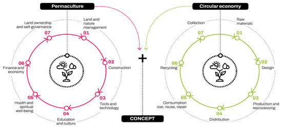
Figure 14.
Principles of permaculture and circular economy.
Figure 14 illustrates the principles of both permaculture and the circular economy, two complementary approaches that converge in promoting sustainable practices and maximizing resource efficiency. Permaculture, focused on sustainable design, advocates for agricultural systems and human settlements that mimic natural ecosystems, fostering biodiversity, renewable energy capture, and the closure of nutrient cycles [44]. In parallel, the circular economy emphasizes a regenerative economic model based on reducing, reusing, recycling, and regenerating, encouraging waste minimization, product reuse and repair, and the efficient use of resources [45]. Both frameworks share a common vision of creating resilient, regenerative, and environmentally respectful systems, resulting in an ideal synergy to address current environmental challenges.
Both theoretical concepts are reflected in the project through strategies that focus on minimizing waste and optimizing resource use. These strategies are evident in the choice of construction systems such as the locally sourced drywall walls that form the new floor levels of the linear park, which respond to the criteria of low environmental impact.
Both permaculture and the circular economy emphasize the value of cultural identity linked to the community. In this sense, the program of spaces is oriented to promote participatory environmental practices aimed at conserving fragile ecosystems and strengthening social dynamics and the connection with the environment.
Furthermore, within the framework of sustainable development, the project aligns with several Sustainable Development Goals (SDGs): SDG 3 (Good Health and Well-being), by contributing to quality of life through enhanced environmental conditions and public spaces; SDG 6 (Clean Water and Sanitation), through water harvesting and reuse systems; SDG 7 (Affordable and Clean Energy); SDG 8 (Decent Work and Economic Growth), by generating employment through sustainable production systems; SDG 11 (Sustainable Cities and Communities), due to its metropolitan-scale impact; and SDG 15 (Life on Land), which frames ecosystem conservation as a key focus of the proposal [46].
3.2. Master Plan
The green belt is located at an elevation of 426 m above sea level, situated at the boundary between the Lomas del Paraíso and the informal settlement Quebrada del Paraíso. It extends for approximately 250 m in length and covers an estimated area of 2 hectares.
Figure 15 illustrates the location of the proposal at the limit of its interaction with the immediate environment, incorporating an access point designed from principles of tactical urbanism. This approach refers to low-cost urban interventions aimed at generating transformations in the use of public space [47]. In particular, an artistic intervention is proposed on the asphalt in the Quebrada del Paraíso human settlement, with the aim of creating a welcoming space that marks the beginning of the journey towards the proposal. This action seeks to activate the use of public space and promote cultural, social and economic dynamics that strengthen the community’s bond with its urban environment.
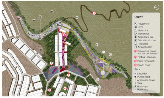
Figure 15.
Master plan and landscape design in the Lomas del Paraíso.
The green belt comprises various functional zones, including workshop areas, playgrounds, mural spaces, an amphitheater, an open plaza, cultivation zones, and viewpoints. These areas were strategically planned to support the preservation of the Lomas del Paraíso and to promote environmental education for the local community, visitors, and tourists.
Additionally, the layout of the green corridor is shown, aligned with the site’s topography and articulated with the adjacent informal settlement of Quebrada del Paraíso. The plant species selected for the green corridor exhibit seasonal variation, which can be appreciated in the rendered visualization.
This master plan reflects the principles of permaculture through its adaptive use of natural topography, diversity of functions, and integration of green infrastructure as a structural component of ecological regeneration. The inclusion of multipurpose public spaces aligned with natural slopes promotes the use of passive strategies and low-impact construction methods.
Figure 16 presents the proposed intervention in Lomas del Paraíso, structured around a master plan that articulates a series of public spaces across the territory while integrating the landscape and topography in a sensitive manner. The sectional diagrams A, B, and C illustrate how the design adapts to the site’s natural slopes, highlighting the strategic placement of key zones such as the children’s play area, community workshop spaces, and the newly proposed amphitheater. The latter is envisioned at a larger scale to host cultural events and strengthen the social role of the existing open plaza.
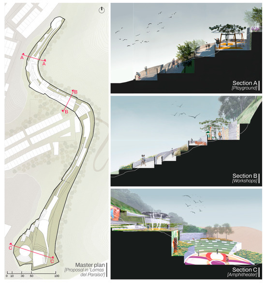
Figure 16.
Green belt cross-sections and topographic design strategies for sloped terrain.
The section diagrams also emphasize how each intervention corresponds to a specific program within the broader ecotourism circuit, while respecting the natural topography. The careful arrangement of seating areas, native vegetation, and pedestrian pathways ensures accessibility and encourages user engagement without compromising the ecosystem. Furthermore, the amphitheater’s partially sunken design increases its capacity while allowing it to blend harmoniously into the landscape, reinforcing the integration between architecture and nature.
In Figure 17, a comparative representation of the landscape is presented during two key moments of the year: the dry season and the wet season. This visualization highlights the seasonal changes in the vegetation of the lomas, showcasing the project’s capacity to adapt to the ecosystem’s natural dynamics. The proposal is conceived as a respectful intervention that coexists with the surrounding environment, reinforcing environmental education and raising awareness about the fragile ecosystems that characterize the Lomas de Villa María del Triunfo. Moreover, the contrast between the dry and wet seasons not only documents the visual changes in the ecosystem, but also underscores the importance of planning interventions that are sensitive to natural cycles.
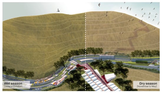
Figure 17.
Green belt proposal in the Lomas del Paraíso during the wet and dry seasons.
During the wet season, the vegetation cover intensifies, providing an immersive experience in local biodiversity; whereas in the dry season, the landscape transforms into an ideal setting for cultural and educational activities. This seasonal duality is harnessed in the proposal to enable a dynamic and resilient use of the territory throughout the year [48].
In terms of circular economy, the spatial distribution optimizes land use efficiency, incorporates local materials, and promotes long-term functionality with minimal environmental cost. Seasonal adaptation, visible in Figure 17, also highlights an efficient use of natural resources throughout the year, respecting ecological rhythms and reducing dependence on artificial maintenance.
3.3. Strategies
Based on the principles of permaculture and circular economy, a series of strategies were established to support ecosystem conservation and strengthen the community bond. These strategies are classified into: equipment strategies for user comfort, sustainable design strategies, and environmental strategies.
3.3.1. Equipment Strategy for User Comfort
In the comprehensive design of this project, a variety of public spaces were incorporated to serve different user groups, including children’s play areas, scenic overlooks, and zones for fairs and murals, extending the intervention into the surrounding residential areas. This approach is grounded in the principles of permaculture and circular economy, with a strong commitment to the use of local materials and community-based labor.
The implementation of diverse types of pavements, tailored to the specific needs of each zone, enhances both functionality and esthetics while reflecting a deep commitment to environmental harmony, community participation, and resource efficiency. These decisions embody permaculture ethics by promoting community empowerment and reducing ecological footprints. In terms of circular economy, the use of materials such as gravel, concrete pavers, and reused wood exemplifies local reuse, waste reduction, and sustainable consumption cycles.
Furthermore, the programming of public spaces prioritizes social interaction, inclusion, and multifunctionality, core values in permaculture design. The integration of an agricultural fair also reinforces circular economy principles by fostering local economic loops and reinvesting value within the community.
- a.
- Public Spaces
The project proposes a sequence of public spaces, with a program designed according to the social dynamics identified within the community, fostering social integration. At the district level, a deficit in public areas was identified; therefore, the program also aims to improve quality of life.
- Materiality
Various materials were used within the green belt, including cement, gravel, concrete pavers, exposed soil, metal mesh, stones, metal grating, and wood.
Cement was selected for its low maintenance and cost, applied particularly in certain paths within the green belt.
Gravel, used in green areas, serves as a boundary between paved roads and cultivation zones. This material is characterized by its water filtration capacity, low maintenance, local origin, and high reusability.
Concrete pavers were used in workshop areas. In addition to their heat-absorbing capacity, they are easy to maintain, low-cost, locally sourced, and contribute significantly to water infiltration—up to 40%.
Exposed soil is employed in vegetated areas, acting as a primary water filter. Its thermal inertia helps retain heat during winter months, supporting the blooming of local species [49]. As a local material, it integrates seamlessly with the surrounding landscape.
Metal grating is implemented in “floating floors,” allowing a 360-degree view beneath the walkways and enabling the observation of plant growth below while people walk through the green belt.
Stones serve as a central element in the proposal, functioning as a prime example of local and reusable material. They are used to build platforms and manage elevation changes, adapting to the terrain’s slope. Combined with metal mesh, they form a solid, durable, low-cost structure that creates engaging spaces reflecting cultural and ancestral heritage.
Wood is incorporated into various furniture elements due to its heat absorption capacity, low maintenance, local origin, and reusability. The project seeks to leverage the renewable and biodegradable properties of wood to align with the material reuse axis of the circular economy concept [50]. Its presence enhances the sustainability of the project, ensuring long-term resilience.
- b.
- Universal Accessibility
The pathway design follows the principle of universal accessibility, ensuring safe mobility for people with disabilities. The circulation route includes ramps that allow access to all areas along the corridor.
- c.
- Floor Typologies
Among the different types of flooring, one of the most notable is the use of metal flooring in the flower zone. This was proposed with the objective of enhancing durability and allowing rainwater drainage while visually connecting the visitor with the flora below (Figure 18).
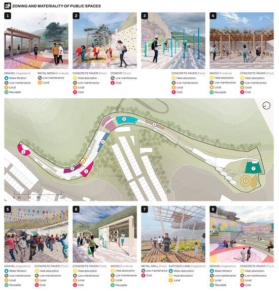
Figure 18.
Public space zoning.
- d.
- Agricultural Fair
The inclusion of agricultural fairs aims to boost the local economy and provide permanent employment opportunities for the community. Furthermore, it strengthens local commerce with the objective of fostering a sustainable and self-sufficient economy that aligns with the cultivation of vegetables in urban gardens (Figure 19).
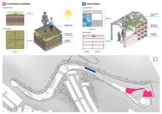
Figure 19.
Construction detail of fair modules and metal flooring.
- e.
- Community Facilities
Among the community-based strategies, emphasis is placed on the ecotourism circuit of the Lomas del Paraíso, which attracts a large number of volunteers who offer various services to visitors. This dynamic reflects a strong connection between local residents and the surrounding environment, especially regarding access to the Lomas. Therefore, the implementation of the green corridor contributes to the preservation of both the urban and environmental identity valued by the local population.
- f.
- Volunteers
The project includes designated spaces for the local volunteer association to carry out activities and develop conservation-focused projects alongside environmentally committed individuals.
- g.
- Workshops
Dedicated areas have been planned for residents of the Lomas del Paraíso area, enabling the development of educational workshops and activities that promote community engagement and benefit local inhabitants.
- h.
- Murals
Created by talented local artists from the Lomas del Paraíso community, the murals are strategically placed throughout the park to express a sense of belonging and cultural identity.
- i.
- Cultural Activities
The existing open plaza currently serves as a landmark for celebrations involving both residents and visitors. As part of the proposal, a new, larger-scale amphitheater has been introduced to accommodate a greater number of attendees, enhancing its role as a cultural, recreational, and community gathering space (Figure 20).
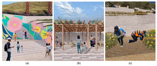
Figure 20.
(a) Murals; (b) workshop space; (c) collaboration with volunteers.
3.3.2. Sustainable Design Strategies
Within the technological strategies, the proposal incorporates a fog-catching network designed to support the irrigation of crops and supply water to common-use areas. In addition, various pieces of furniture are constructed using local labor and materials to minimize the carbon footprint while also creating job opportunities.
The integration of fog catchers and terracing systems embodies the permaculture principle of “catch and store energy,” utilizing natural climatic conditions to sustain life. Locally made furniture and lighting powered by clean energy reduce dependence on external inputs and highlight the project’s alignment with regenerative design.
From a circular economy perspective, the project limits waste and promotes closed cycles through the use of local resources, modular construction, and renewable energy, supporting both environmental goals and economic inclusion.
- a.
- Terracing
Given the site’s topography, a terracing system is employed to adapt the land into large, level platforms. This method not only facilitates construction but also reflects vernacular practices observed in the immediate surroundings.
- b.
- Fog Catchers
The area’s high humidity levels make the implementation of fog catchers particularly suitable. These systems capture moisture from the fog, store the collected water, and make it available for reuse. Furthermore, fog catchers serve as tangible examples of climate adaptation and resilience, as evidenced by green infrastructure projects implemented in the Pantanos de Villa to support biodiversity conservation and strengthen the ecological urban fabric [51].
- c.
- Lighting Powered by Clean Energy
The design of the light fixtures draws inspiration from the Amancaes flower, an emblematic species that is deeply rooted in the environmental identity of the region. The use of LED lighting reduces environmental impact and reinforces the proposal’s alignment with clean energy principles.
In Figure 21, both the design considerations for the fog catchers and the lighting elements are illustrated. In the case of fog catchers, as a fog harvesting system in Lomas del Paraíso, they represent an ecologically and technologically viable strategy for areas with low rainfall and high atmospheric humidity, such as the Lomas del Paraíso in Lima.
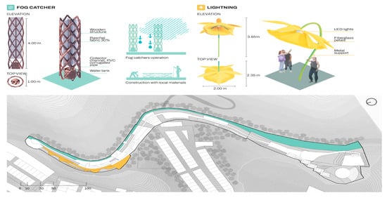
Figure 21.
Detail of lighting and fog catcher design.
3.3.3. Environmental Strategies
The landscape treatment not only enhances the esthetic quality of the area, but also highlights the diversity of species present in the ecosystem of Lomas del Paraíso. This design aims to be not only visually appealing but also educational, by emphasizing the natural value of the region for the local population.
The landscape restoration efforts strongly resonate with permaculture’s commitment to biodiversity, native species, and ecological cycles. Urban gardens and interpretative components educate users while empowering them to co-manage the ecosystem.
In line with circular economy principles, these gardens and revegetation practices extend the life and value of natural resources, support food sovereignty, and transform organic waste into compost or productive inputs—closing nutrient loops and reinforcing local sustainability.
The combination of ecological design, local participation, and circular systems in all strategies consolidates the proposal as an integrated model of regenerative urban intervention.
- a.
- Urban Gardens
Within the corridor, spaces will be allocated for the cultivation of vegetables with the goal of reinforcing the community’s engagement in activities within the proposal. This initiative aims to foster the development of a self-sufficient community and promote sustainable practices. In this sense, the implementation of gardens, educational workshops, and agricultural fairs is proposed, where visitors can learn about biological cycles, the importance of native species in the ecosystem, and how human practices affect ecological balance. These approaches follow models of successful interpretation centers, such as the one developed in Cusco for the revaluation of Andean flora and fauna [52].
- b.
- Flora Species
Among the environmental strategies for the ecological restoration of Lomas del Paraíso, the revaluation and protection of native plant species is fundamental. The Amancaes flower (Ismene amancaes), a natural symbol of Lima, represents not only a landscape and cultural value but also an ecological one, as it is a species adapted to fog conditions and capable of regenerating naturally in minimally disturbed soils. Other species, such as tara (Caesalpinia spinosa), aromo (Vachellia macracantha), and verdolaga (Portulaca oleracea), contribute to soil stabilization, fertility enhancement, and the support of local biodiversity [37,38,39]. Promoting the assisted propagation of these species can be key to restoring vegetation cover and reactivating ecosystem processes such as moisture capture, pollination, and seed dispersal, which are essential for the ecosystem’s resilience in the face of urban pressure (Figure 22).
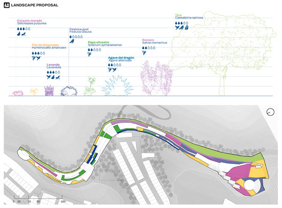
Figure 22.
Landscape proposal and distribution of native and adaptive plant species in the intervention area of “Lomas del Paraíso”.
The selection of native species for restoration strategies must consider not only their ecological resilience but also their ability to provide ecosystem services. Certain plants, such as Nolana sp., exhibit unique physiological adaptations that enable them to thrive with minimal water resources, making them ideal pioneer species for covering eroded soils. Furthermore, species such as Oxalis megalorrhiza and Tillandsia latifolia can serve as indicators of environmental health due to their sensitivity to microclimatic changes and pollution. Integrating these species into revegetation programs not only aids landscape recovery but also supports the monitoring of the effectiveness of implemented actions, linking conservation with applied scientific knowledge.
3.3.4. Comparative Synthesis of Strategic Models
To complement the proposed strategies for the Lomas del Paraíso Green Belt, this section presents a comparative analysis of selected reference cases through key analytical criteria. The objective is not to provide a descriptive overview, as performed in the introduction, but rather to assess how each project strategically addresses challenges such as urban pressure, socio-ecological integration, ecosystem adaptation, transferability, and sustainability innovation. This operational synthesis allows for a critical positioning of the Lomas del Paraíso proposal within a broader spectrum of regional and conceptual approaches, highlighting both its limitations and its replicable strengths (Table 3).

Table 3.
Alignment of the Lomas del Paraíso Green Belt proposal with benchmark cases from Latin America.
3.4. Water Resource Utilization and Fog Water Harvesting for Irrigation
Fog catchers are devices that allow for the collection of water from coastal fog, which can be used for irrigating native species, restoring the ecosystem, and strengthening community water security. The proposed model consists of a 4.00 m high wooden structure with a diameter of 1.0 m, covered with 30% Raschel mesh, and equipped with a corrugated PVC channel that directs water to a storage tank located at the base. This analysis assumes a humid season context, with relative humidity close to 90%.
Capture Surface Area. The effective capture surface area is estimated based on the lateral area of the cylindrical collector [53]:
where r is the radius (0.5 m) and h is the height (4.0 m):
Acapture = 2πrh
Acapture = 2π(0.5)(4.0) ≈ 12.57 m2
Estimated Water Collection. The amount of water collected depends on the collection efficiency per square meter per day. An average value of 3 L/m2/day is assumed, based on previous regional studies [54,55]:
Qdaimly = Acapture × E Qdaily = 12.57 m2 × 3 L/m2/day = 37.71 L/day
As shown in Table 4, the installation of 15 fog catchers along the proposed ecological edge serves a dual function: capturing atmospheric water for ecological uses and reinforcing the educational approach of the green belt. The 523 m long route is enriched by patches of native vegetation adapted to arid climates, with a total intervention area of 20,123 m2, including paths and vegetation (Figure 22).

Table 4.
Daily, monthly, and annual water capture by fog catchers.
Water Needs of Proposed Flora. The plant palette consists of native and xerophytic species. The selection criteria prioritize low water requirements, while some species with moderate needs are included due to their symbolic, ecological, or functional value (Table 5).

Table 5.
Botanical characteristics and estimated water requirements per area.
Total Estimated Monthly Water Requirement ≈ 18,514.64 L/month.
The estimated water yield assumes a relative humidity of 90%, based on average fog conditions observed during the humid season in the Peruvian coastal hills. However, this value may vary significantly depending on interannual climate fluctuations, particularly during ENSO events (El Niño or La Niña), which alter fog density, cloud cover, and wind patterns. Therefore, the actual efficiency of fog harvesting systems could decrease or increase depending on these climatic anomalies. It is recommended to incorporate a range of humidity scenarios or long-term monitoring data for future applications.
In Table 6, these estimates are based on empirical assumptions of linear correlation between fog water yield and relative humidity, assuming constant wind and mesh efficiency. Actual performance may vary depending on topography, fog density, and wind speed. ENSO-related climate anomalies can significantly impact fog occurrence and water availability.

Table 6.
Estimated fog water yield under different relative humidity scenarios.
The installation of fog catchers in Lomas del Paraíso establishes a direct relationship between alternative water availability and ecological restoration in arid environments. With an effective capture surface of 12.57 m2 per unit and an efficiency of 3 L/m2/day, the 15 proposed devices yield a combined total of 565.65 L/day, equivalent to 16,965 L/month. This volume covers approximately 91.6% of the monthly irrigation needs for the selected plant species, assuming humid season conditions. The remaining water requirement can be addressed through complementary strategies such as drip irrigation, seasonal water storage, and localized runoff harvesting, thereby optimizing resource use.
The adopted approach, which integrates technical efficiency, ecological restoration, and community involvement, underscores the relevance of nature-based solutions to address water and climate challenges in vulnerable urban environments. The proposal not only enhances reforestation processes and the conservation of native species adapted to xeric conditions but also promotes a replicable model of educational ecological infrastructure. This type of intervention supports a transition toward more resilient and self-sufficient landscapes, where water sustainability is directly linked to environmental quality and territorial identity.
In summary, the results demonstrate how each design and programmatic decision within the green belt responds to key principles of permaculture and circular economy. From landscape restoration and adaptive construction to community participation and sustainable resource management, the project integrates regenerative practices that strengthen ecological and social resilience at a local scale.
4. Discussion
4.1. Local Strategies for Ecological and Social Resilience in Lomas del Paraíso
This research highlights the importance of undertaking comprehensive interventions in Lima’s coastal lomas ecosystems, particularly in Lomas del Paraíso, in response to increasing pressures from informal urban expansion, environmental degradation, and the lack of public spaces for the local population. In this context, the implementation of a green belt emerges not only as a containment strategy against uncontrolled urbanization but also as a tool for ecological regeneration, social revitalization, and urban resilience.
For the first objective, to determine the extent to which ecological restoration through native vegetation contributes to countering urban expansion in Lomas del Paraíso, the comparative analysis with Medellín’s Jardín Circunvalar reveals fundamental similarities in the intention to halt urban sprawl through the integration of green spaces using native species as a means of habitat recovery. These spaces function both as environmental infrastructure and areas of social cohesion. Both projects aim to delineate the urban edge through landscape-based interventions that promote sustainable development and ecological recovery [64]. However, unlike the Jardín Circunvalar, which is part of a consolidated metropolitan planning strategy, the Lomas del Paraíso project stems from an academic and community-led initiative. This underscores the value of local actions as potential catalysts for urban transformation, even in the absence of strong institutional support, drawing on principles offered by permaculture.
For the second objective, to establish the extent to which community participation contributes to countering urban expansion in Lomas del Paraíso, the case of Parque Arví in Medellín provides a useful point of comparison. While its primary focus also centers on the conservation of a natural ecosystem (high Andean forest), its structure as a natural reserve with ecotourism goals offers a complementary vision. The proposal for Lomas del Paraíso draws on this experience by establishing an ecotourism circuit, yet places greater emphasis on the involvement of the local community as the primary steward of the site [65]. While Parque Arví operates under formal institutional governance and serves a broader tourism audience, the green belt in Lomas del Paraíso functions as a neighborhood-scale infrastructure aimed at generating direct economic, educational, and social opportunities for nearby residents. Both initiatives share an understanding of ecotourism as a conservation strategy and incorporate environmental education as a core component, in addition to promoting community participation as both a tool for environmental awareness and a source of income, based on the principles of the circular economy.
For the third objective, to define the extent to which the use of sustainable technologies, such as fog catchers, contributes to countering urban expansion in Lomas del Paraíso, the findings are closely related to the article “Islands in the Fog: A Systematic Review of South American Coastal Lomas”. This article is particularly relevant as it offers an ecological and climatic diagnosis that aligns with the present study. Its recognition of fog as a central driver in the existence and functioning of lomas ecosystems supports the use of fog catchers and the selection of plant species adapted to humid microclimates [15]. While the cited article adopts an academic approach centered on ecosystem characterization and comparative analysis, this research complements it through concrete spatial and design applications. Moreover, whereas the article emphasizes the vulnerability of these ecosystems to climate change, the green belt project introduces a proactive measure to mitigate such impacts through plant restoration, community engagement, and the reactivation of lost ecosystem functions.
Together, these comparisons support a comprehensive evaluation of the proposed intervention. Although the ecological and urban contexts may differ, there are common principles that can be successfully adapted across diverse scales and realities: the integration of community and nature, the recognition of landscape as living infrastructure, resilient planning in the face of environmental threats, and a multidimensional approach (ecological, social, and economic). The proposed green belt in Lomas del Paraíso aligns with these global practices while offering a distinct perspective from the Global South. Rooted in local action and adapted to coastal microclimates, it serves as an example of urban innovation grounded in nature-based solutions.
4.2. Transferable Perspectives for Fragile Ecosystems
The strategies developed in Lomas del Paraíso, particularly the use of community-managed fog water harvesting systems, offer great potential for replication in other fog-dependent regions around the world. In areas such as the Chilean lomas, the Canary Islands, and the coastal foothills of North Africa, where fog represents one of the few consistent sources of moisture, fog catchers emerge as an affordable, low-impact technological solution. When combined with native vegetation, these devices can form the basis of effective green corridors that not only resist urban expansion but also regenerate local ecosystems.
What distinguishes the Lomas del Paraíso model is its emphasis on community agency and knowledge. While many fog harvesting systems around the world are implemented by NGOs or academic institutions, the participatory nature of this project highlights the role of local residents not just as beneficiaries, but as active managers of ecological infrastructure. This community-based approach is particularly relevant in the Global South, where state support is often limited and environmental degradation disproportionately affects the most vulnerable populations.
By combining fog harvesting technologies with principles from permaculture and the circular economy, this initiative demonstrates how ecologically fragile landscapes can be restored and protected through integrated, locally led strategies. The experience of Lomas del Paraíso offers a scalable and adaptable model for sustainable urban-rural transitions in dry coastal areas, providing valuable lessons for planners, ecologists, and decision-makers facing similar environmental and social challenges worldwide.
5. Conclusions
This research demonstrates that the implementation of a green belt in Lomas del Paraíso represents a significant strategy to address the environmental, social, and urban pressures affecting the fragile ecosystems of Metropolitan Lima. Through a multidisciplinary approach that combines ecological, urban, community, and climatic analyses, the proposed intervention integrates conservation efforts with sustainable local development initiatives. The green belt not only serves as a physical boundary against informal urban expansion, but also revalorizes the territory through the activation of public spaces, ecological restoration, and the strengthening of community ties.
The study highlights the importance of adapting global principles to local realities. Unlike large-scale models such as Medellín’s Jardín Circunvalar or Parque Arví, the proposal for Lomas del Paraíso operates at a neighborhood scale and with limited resources. Nevertheless, it achieves significant impacts by engaging the community as the main agent of change. The incorporation of principles from permaculture, circular economy, and the Sustainable Development Goals (SDGs) contributes to a regenerative vision of the territory, where nature and society coexist in balance.
Furthermore, the environmental value of the lomas ecosystem is reinforced through the connection between urban design, seasonal cycles, the fog-based microclimate, and native species that shape its unique identity. The green belt becomes a mechanism that not only protects but also communicates and educates, functioning as infrastructure that encourages environmental stewardship and community ownership. In this sense, the experience developed in Lomas del Paraíso may serve as a replicable model for other vulnerable areas in Lima and across Latin American cities facing similar challenges related to disordered expansion and ecosystem loss.
In conclusion, this type of intervention must be supported by urban conservation policies, continuous citizen participation, and multiscalar planning that acknowledges the strategic value of fragile urban ecosystems. The green belt should not be understood solely as an ecological barrier, but rather as a living infrastructure that actively contributes to the creation of more sustainable, resilient, and inclusive cities.
Author Contributions
Methodology, D.E.; Investigation, P.V., P.R., A.A.-B. and L.G. All authors have read and agreed to the published version of the manuscript.
Funding
This research received no external funding.
Data Availability Statement
The original contributions presented in this study are included in the article. Further inquiries can be directed to the corresponding author.
Conflicts of Interest
The authors declare no conflict of interest.
References
- United Nations. Biodiversity. United Nations Climate Change. Available online: https://www.un.org/es/climatechange/science/climate-issues/biodiversity (accessed on 12 February 2025).
- Ministerio del Ambiente del Perú (MINAM). Ecosistemas. MINAM. Available online: https://www.minam.gob.pe/diversidadbiologica/nuestras-lineas-de-intervencion/direccion-de-conservacion-sostenible-de-ecosistemas-y-especies/ecosistemas/ (accessed on 12 February 2025).
- ¿Qué es un Ecosistema? Available online: https://www.nationalgeographicla.com/medio-ambiente/2022/08/que-es-un-ecosistema (accessed on 12 February 2025).
- Balvanera, P.; Cotler, H. Acercamientos al estudio de los servicios ecosistémicos. Gac. Ecol. 2007, 84–85, 8–15. [Google Scholar]
- Centro Nacional de Planeamiento Estratégico (CEPLAN). El Sector Forestal en el Perú. Gobierno del Perú. Available online: https://cdn.www.gob.pe/uploads/document/file/5605664/4973838-ceplan-el-sector-forestal-en-el-peru.pdf (accessed on 12 February 2025).
- Von May, R.; Catenazzi, A.; Angulo, A.; Venegas, P.J.; Aguilar, C. Investigación y conservación de la biodiversidad en Perú: Importancia del uso de técnicas modernas y procedimientos administrativos eficientes. Rev. Peru Biol. 2012, 19, 351–358. [Google Scholar] [CrossRef]
- Ministerio de Desarrollo Agrario y Riego. Lineamientos para la Identificación de Ecosistemas Frágiles y su Incorporación en la Lista Sectorial de Ecosistemas Frágiles. 2024. Available online: https://repositorio.serfor.gob.pe/bitstream/SERFOR/968/1/SERFOR%202024%20Lineamiento%20ZF.pdf (accessed on 12 May 2025).
- SERFOR (2025). “Nuevo modelo de gestión sobre los ecosistemas frágiles sectoriales: ¿qué podemos esperar?”. Actualidad Ambiental. Available online: https://www.actualidadambiental.pe/nuevo-modelo-de-gestion-sobre-los-ecosistemas-fragiles-sectoriales-que-podemos-esperar/ (accessed on 9 July 2025).
- Sanchez, Z. Impulsores de cambio de uso de suelo en ecosistemas de lomas: El caso de las Lomas del Sur de Lima. South Sustain. 2022, 3, e066. [Google Scholar] [CrossRef]
- Alonso, C.; Jesús, R. Problemática socioambiental de las lomas costeras de Lima: Una revisión. Rev. Cienc. Soc. 2021, 2, 18–28. [Google Scholar]
- Ministerio del Ambiente (MINAM) (2020). Decreto Supremo N.º 011-2019-MINAM que establece el Área de Conservación Regional Sistema de Lomas de Lima. Available online: https://sinia.minam.gob.pe/normas/decreto-supremo-que-establece-area-conservacion-regional-sistema-lomas (accessed on 9 July 2025).
- Riveros, A.; Vásquez, A.; Ludeña, B.; Vergara, J. Infraestructura verde urbana: Tipos, funciones y oportunidades para el desarrollo de corredores verdes urbanos en Santiago de Chile. In Ciudad y Calidad de Vida. Indagaciones y Propuestas para un Habitar Sustentable; USACH: Santiago, Chile, 2015; pp. 93–107. [Google Scholar]
- Marín-Vanegas, D.F.; Serna-Velásquez, J.D. Frontera dinámica: Contraste urbano rural en el Borde oriental de Medellín Colombia. El Ágora USB 2020, 20, 219–234. [Google Scholar] [CrossRef]
- Trujillo, C. Arví, un Destino de Naturaleza Sostenible. El Colombiano, 10 March 2015. Available online: https://www.elcolombiano.com/antioquia/arvi-un-destino-de-naturaleza-sostenible-FH1559711 (accessed on 10 March 2025).
- Gonzales, F.N.; Craven, D.; Armesto, J.J. Islands in the mist: A systematic review of the coastal lomas of South America. J. Arid. Environ. 2023, 211, 104942. [Google Scholar] [CrossRef]
- Trujillo, C. Jardín Circunvalar, Ejemplo en el país de Sostenibilidad Ambiental. El Colombiano, 11 May 2015. Available online: https://www.elcolombiano.com/antioquia/jardin-circunvalar-ejemplo-en-el-pais-de-sostenibilidad-ambiental-LM2079379 (accessed on 11 May 2025).
- Mercado, D. La Operación del Reconocido Parque Arví está en Riesgo Por Graves Problemas Financieros. El Tiempo, 25 May 2023. Available online: https://www.eltiempo.com/colombia/medellin/medellin-los-graes-problemas-financieros-que-tienen-al-parque-arvi-a-punto-de-cerrar-818122 (accessed on 25 May 2025).
- Municipalidad de Lima. Expediente Técnico: Propuesta de Área de Conservación Regional Sistema de Lomas de Lima; Programa de Gobierno Regional de Lima: Lima, Peru, 2019. Available online: https://smia.munlima.gob.pe/uploads/documento/281c735d3de6f8a5.pdf (accessed on 20 May 2025).
- Programa de las Naciones Unidas para el Desarrollo. Conservar las Lomas, un Ecosistema Único y Vital en Lima. 2022. Available online: https://www.undp.org/es/peru/noticias/conservar-las-lomas-un-ecosistema-unico-y-vital-en-lima (accessed on 26 March 2025).
- Ministerio del Ambiente. ¡Jóvenes al Rescate!... de las Lomas de Villa María del Triunfo. 22 October 2020. Available online: https://www.gob.pe/institucion/minam/noticias/309303-jovenes-al-rescate-de-las-lomas-de-villa-maria-del-triunfo (accessed on 10 June 2025).
- Andina. Ministro del Ambiente: Fortaleceremos la Protección y Conservación de Lomas de Lima; Andina: Lima, Peru, 2015; Available online: https://andina.pe/agencia/noticia-ministro-del-ambiente-fortaleceremos-proteccion-y-conservacion-lomas-lima-865797.aspx (accessed on 16 April 2025).
- Asociación UNACEM. Asociación UNACEM Fortalece Capacidades Locales para Realizar Turismo Responsable en Lomas de Villa María del Triunfo; Asociación UNACEM: Pachacamac, Peru, 2022; Available online: https://asociacionunacem.org/asociacion-unacem-contribuye-con-el-turismo-responsable-en-lomas-de-paraiso-en-villa-maria-del-triunfo/ (accessed on 23 February 2025).
- Nieuwland, B.; Mamani, J.M. Las lomas de Lima: Enfocando ecosistemas desérticos como espacios abiertos en Lima metropolitana. Espac. Desarro. 2017, 29, 109–133. [Google Scholar] [CrossRef]
- Romero Valle, A.O.; Medina Salcedo, M.R.; Ocaña Canales, J.C. Caracterización biológica durante el fenómeno “El Niño” en el ecosistema de las Lomas de Lachay. An. Cient. (Univ. Nac. Agrar. La Molina) 2018, 79, 316–327. [Google Scholar]
- Ipanaqué, C. Lomas de Lima: Un Ecosistema en Peligro; Conservamos por Naturaleza: San Isidro, Peru, 2019; Available online: https://www.conservamospornaturaleza.org/noticia/lomas-lima-peligro (accessed on 4 April 2025).
- Servicio Nacional Forestal y de Fauna Silvestre. Instituciones se Unen Para Proteger y Recuperar las Lomas de Villa María del Triunfo; SERFOR: Magdalena del Mar, Peru, 2021. Available online: https://www.gob.pe/institucion/serfor/noticias/502658-instituciones-se-unen-para-proteger-y-recuperar-las-lomas-de-villa-maria-del-triunfo (accessed on 5 March 2025).
- Cordova Cordova, J.R.; Luque Salazar, J.F. Tráfico de Terrenos y Degradación del Ecosistema Natural en Lomas de Paraíso, Villa María del Triunfo, Lima-2022; Universidad César Vallejo: Lima, Peru, 2022. [Google Scholar]
- García, R.; Miyashiro, J.; Orejón, C.; Pizarro, F. Crecimiento Urbano, Cambio Climático y Ecosistemas Frágiles: El Caso de las Lomas de Villa María del Triunfo en Lima Sur; DESCO—Centro de Estudios y Promoción del Desarrollo; Urbano: Lima, Peru, 2014; Volume 25, pp. 181–198. [Google Scholar]
- Celis Valdez, D.; Moreno Gutierrez, S.L. Diagnóstico del sistema turístico de Lomas de Paraíso en Villa María del Triunfo, 2023. Available online: https://hdl.handle.net/20.500.12692/145537 (accessed on 25 March 2025).
- Sistema Nacional de Información Ambiental (SINIA). Indicador de Área Verde por Habitante en Lima Metropolitana; SINIA: Lima, Perú, 2022. Available online: https://sinia.minam.gob.pe (accessed on 28 April 2025).
- Vogler, D.; Suzanne, M.; Amanda, S. Stakeholder Analysis in Environmental and Conservation Planning. Lessons Conserv. 2017, 7, 5–16. [Google Scholar] [CrossRef]
- SENAMHI. Weather Forecast for Lima. Servicio Nacional de Meteorología e Hidrología del Perú. Available online: https://www.senamhi.gob.pe/main.php?dp=lima&p=pronostico-meteorologico (accessed on 29 March 2025).
- Observatorio Geográfico de América Latina. Microclimatic Conditions in Coastal Lomas and Health Risks. Available online: https://observatoriogeograficoamericalatina.org.mx/egal16/Procesosambientales/Climatologia/14.pdf (accessed on 28 May 2025).
- United Nations Development Programme (UNDP). EbA Lomas Project. Available online: https://www.undp.org/sites/g/files/zskgke326/files/migration/latinamerica/UNDP-RBLAC-ProyectoEbAPE.pdf (accessed on 8 May 2025).
- Castañeda Córdova, L.Z.; Sánchez Infantas, E.H.; Quinteros Carlos, Z.D. Analysis of the Behavior of Biotic Variables in the Lachay National Reserve during the El Niño Event (1998–2001, 2010). Ecol. Appl. 2022, 21, 35–47. [Google Scholar] [CrossRef]
- Pinche, C. Fog Water Harvesting in the Coastal Lomas of Peru. Ing. Hidraul. Mex. 1996, 11, 49–54. Available online: https://dialnet.unirioja.es/servlet/articulo?codigo=7357089 (accessed on 29 May 2025).
- Escobar, M.; García, M. Camanchaca: Ethnonymic and Fog Flows on the Northern Coast of Chile. Rev. Geogr. Norte Gd. 2017, 68, 11–32. [Google Scholar]
- Suni, M.L.; Pascual, E.; Jara, E. Reproductive Development of “Amancay” Ismene amancaes (Amaryllidaceae) in Its Natural Environment. Rev. Peru. Biol. 2011, 18, 293–297. [Google Scholar] [CrossRef]
- González, M.; Pérez, J. Characterization of Melliferous Species in the Tropical Dry Forest Aimed at Their Conservation. Rev. Cfores 2021, 9, 377–394. Available online: https://www.researchgate.net/publication/356695243 (accessed on 19 May 2025).
- Tovar, C.; Sánchez Infantas, E.; Teixeira Roth, V. Vegetation Community Dynamics in Oasis-Like Fog Lomas of Central Peru after the Extreme Rainfall of the 1997–1998 El Niño Event. PLoS ONE 2018, 13, e0190572. [Google Scholar]
- Servicio Nacional Forestal y de Fauna Silvestre (SERFOR). National Forest and Wildlife Inventory—Coastal Ecozone. Available online: https://sniffs.serfor.gob.pe/inventarios/pu/panel1/index.html (accessed on 10 April 2025).
- Marín, G.; Eulalia, M. Permaculture as a Contribution to Ecological Ethics. Prod. Limpia 2015, 10, 64–72. [Google Scholar]
- Cerdá, E.; Khalilova, A. Circular Economy. Econ. Ind. 2016, 401, 11–20. [Google Scholar]
- Serrano García, P. Permaculture as an Instrument for Local Development and Social Innovation. In Proceedings of the Conference: Professionals and Tools for Local Development and Their Territorial Synergies. Evaluation and Future Proposals; University of Alicante Publications Service: Alicante, Spain, 2016. [Google Scholar]
- Prieto-Sandoval, V.; Jaca, C.; Ormazabal, M. Circular economy: Relationship with the evolution of the sustainability concept and strategies for its implementation. Mem. Investig. Ing. 2017, 15, 1–15. [Google Scholar]
- United Nations. Sustainable Development Goals. Available online: https://www.un.org/sustainabledevelopment/es/objetivos-de-desarrollo-sostenible/ (accessed on 15 May 2025).
- Lydon, M.; Anthony, G. Tactical urbanism: Short-term action for long-term change. Urban Des. Int. 2015, 23, 66. [Google Scholar] [CrossRef]
- Champi Calvo, D.F.; Berrocal Sánchez, M.M.; Jorge Cruzate, S.L.; Aucahuaque Guzmán, V. Servicios ecosistémicos culturales y su contribución a la calidad de vida urbana en las Lomas El Paraíso, 2023. U. Llaqta 2024, 2, 61–81. [Google Scholar] [CrossRef]
- Keesstra, S.D.; Geissen, V.; Mosse, K.; Piiranen, S.; Scudiero, E.; Leistra, M.; van Schaik, L. Soil as a filter for groundwater quality. Curr. Opin. Environ. Sustain. 2012, 4, 507–516. [Google Scholar] [CrossRef]
- Hernández, G.C.; Elgueta, P.M. Wood as a Sustainable Construction Material; INFOR: New York, NY, USA, 2020. [Google Scholar] [CrossRef]
- Esenarro, D.; Vásquez, P.; Acosta-Banda, A.; Raymundo, V. Green Infrastructure as a Sustainability Strategy for Biodiversity Preservation: The Case Study of Pantanos de Villa, Lima, Peru. Urban Sci. 2024, 8, 156. [Google Scholar] [CrossRef]
- Esenarro, D.; Vasquez, P.; Morales, W.; Raymundo, V. Interpretation Center for the Revaluation of Flora and Fauna in Cusco, Peru. Buildings 2023, 13, 2345. [Google Scholar] [CrossRef]
- Ritter, A.; Regalado, C.M.; Guerra, J.C. Quantification of Fog Water Collection in Three Locations of Tenerife (Canary Islands). Water 2015, 7, 3306–3319. [Google Scholar] [CrossRef]
- Albornoz, F.; del Río, C.; Carter, V.; Escobar, R.; Vásquez, L. Fog Water Collection for Local Greenhouse Vegetable Production in the Atacama Desert. Sustainability 2023, 15, 15720. [Google Scholar] [CrossRef]
- Laurre, C.P. Captación de agua de niebla en lomas de la costa peruana. Tecnol. Cienc. Agua 1996, 11, 49–54. [Google Scholar]
- Wisconsin Horticulture. Purple Heart, Tradescantia Pallida. Available online: https://hort.extension.wisc.edu/articles/purple-heart-tradescantia-pallida/ (accessed on 28 May 2025).
- Palacios Vallejo, J.A. Momento de riego y tamaño de bulbo en el rebrote y floración del Amancay (Ismene amancaes Ruiz & Pavón). An. Científicos 2017, 78, 1–10. [Google Scholar] [CrossRef]
- Santos Dela Cruz, E.G.; Rojas Lazo, O.J.; Mayta Huatuco, R.A.; Sanchez Marquez, C.; Álvarez Díaz, E.O. Diseño, elaboración e implementación de un prototipo híbrido para la obtención de agua del medio ambiente haciendo uso de un sistema atrapa niebla rotatorio con un sistema basado en efecto Peltier. In Proceedings of the Vigésima Conferencia Iberoamericana en Sistemas, Cibernética e Informática (CISCI 2021); Universidad Nacional Mayor de San Marcos: Lima, Perú, 2021; Available online: https://www.iiis.org/cds2021/cd2021summer/papers/ca291ig.pdf (accessed on 28 May 2025).
- Huang, B. Turfgrass water requirements and factors affecting water usage. In Water Quality and Quantity Issues for Turfgrass in Urban Landscapes; Beard, J.B., Kenna, M.P., Eds.; CAST Special Publication. No. 27; Council for Agricultural Science and Technology: Ames, IA, USA, 2008; pp. 193–205. [Google Scholar]
- Djaman, K.; Irmak, S.; Koudahe, K.; Allen, S. Irrigation Management in Potato (Solanum tuberosum L.) Production: A Review. Sustainability 2021, 13, 1504. [Google Scholar] [CrossRef]
- Davis, S.C.; Kuzmick, E.R.; Niechayev, N.; Hunsaker, D.J. Productivity and water use efficiency of Agave americana in the first field trial as bioenergy feedstock on arid lands. GCB Bioenergy 2017, 9, 314–325. [Google Scholar] [CrossRef]
- Ghamarnia, H.; Ameri, S.; Nekookish, M. Investigating the Possibility of Rosemary (Rosmarinus officinalis L.) Use of Shallow Groundwater with Different Qualities. J. Water Resour. Agric. 2022, 36, 287–298. [Google Scholar]
- Programa Desarrollo Rural Sostenible de la Cooperación Técnica Alemana GTZ; Asociación Civil Tierra. Manual: El Cultivo de Tara en Cajamarca, Peru, 2007. Available online: https://cdn.www.gob.pe/uploads/document/file/1908197/Manual%20El%20cultivo%20de%20tara%20en%20Cajamarca.pdf.pdf (accessed on 29 May 2025).
- Echeverry Tamayo, J.D. Medellín: A City of Crossroads. Poverty, Urban Model and Social Change in the Green Belt Project. Territorios 2019, 40, 273–289. [Google Scholar] [CrossRef]
- Gutiérrez, C. Urban Furniture for Arví Park/Escala Urbana Arquitectura. ArchDaily Perú, 16 May 2012. Available online: https://www.archdaily.pe/pe/02-157719/mobiliario-urbano-para-el-parque-arvi-escala-urbana-arquitectura (accessed on 29 May 2025).
Disclaimer/Publisher’s Note: The statements, opinions and data contained in all publications are solely those of the individual author(s) and contributor(s) and not of MDPI and/or the editor(s). MDPI and/or the editor(s) disclaim responsibility for any injury to people or property resulting from any ideas, methods, instructions or products referred to in the content. |
© 2025 by the authors. Licensee MDPI, Basel, Switzerland. This article is an open access article distributed under the terms and conditions of the Creative Commons Attribution (CC BY) license (https://creativecommons.org/licenses/by/4.0/).