Article

Multi-Annual Dendroclimatic Patterns for the Desert National Wildlife Refuge, Southern Nevada, USA

by
Franco Biondi
1,* and
James Roberts
2
1
DendroLab, Department of Natural Resources and Environmental Science, University of Nevada, Mail Stop 0186, Reno, NV 89557, USA
2
U.S. Fish and Wildlife Service, Pacific Southwest Region, 2800 Cottage Way, W-2606, Sacramento, CA 95825, USA
*
Author to whom correspondence should be addressed.
Forests 2025, 16(7), 1142; https://doi.org/10.3390/f16071142
Submission received: 19 May 2025 / Revised: 7 July 2025 / Accepted: 9 July 2025 / Published: 10 July 2025
(This article belongs to the Special Issue Environmental Signals in Tree Rings)

Abstract

Ponderosa pine (Pinus ponderosa Lawson & C. Lawson) forests in the western United States have experienced reduced fire frequency since Euro-American settlement, usually because of successful fire suppression policies and even without such human impacts at remote sites in the Great Basin and Mojave Deserts. In an effort to improve our understanding of long-term environmental dynamics in sky-island ecosystems, we developed tree-ring chronologies from ponderosa pines located in the Sheep Mountain Range of southern Nevada, inside the Desert National Wildlife Refuge (DNWR). After comparing those dendrochronological records with other ones available for the south-central Great Basin, we analyzed their climatic response using station-recorded monthly precipitation and air temperature data from 1950 to 2024. The main climatic signal was December through May total precipitation, which was then reconstructed at annual resolution over the past five centuries, from 1490 to 2011 CE. The mean episode duration was 2.6 years, and the maximum drought duration was 11 years (1924–1934; the “Dust Bowl” period), while the longest episode, 19 years (1905–1923), is known throughout North America as the “early 1900s pluvial”. By quantifying multi-annual dry and wet episodes, the period since DNWR establishment was placed in a long-term dendroclimatic framework, allowing us to estimate the potential drought resilience of its unique, tree-dominated environments.

1. Introduction

The Great Basin and Mojave Deserts of the western USA are characterized by arid and semi-arid conditions together with a complex topography and pronounced elevation gradients in precipitation and temperature [1,2]. Latitudinal climate variability is characterized by a transition from winter and spring precipitation, with associated snowpack dynamics, in the northern areas to an increase in summertime rainfall in the southern areas brought by the northwest edge of the North American Monsoon system [3]. At high elevations, sky-island forests can be found that experience dry and hot summers as well as cold and snowy winters [4]. One of the conifer species that dominate montane ecosystems in this region is ponderosa pine (Pinus ponderosa Lawson & C. Lawson) [5], whose large geographic range, extending from Canada to Mexico, has recently revealed a significant amount of genetic variability [6,7].
Ponderosa pine is also a fire-adapted species that typically experiences relatively frequent (every 5–35 years), low-intensity, low-severity, and patchy wildfire regimes [8,9]. In many areas, these ecosystems have been altered after Euro-American settlement because of active fire suppression, which has increased fuel accumulation and generated a widespread fire deficit despite increasing area being burned in recent decades [10]. Recently completed research uncovered decreased fire frequency in the south-central Great Basin [11,12] and in the Mojave Desert [13] from the late 1800s to present compared to the previous three centuries, even without any record of active fire management. In the absence of natural low-severity fires, old-growth ponderosa pine habitats must be managed with prescribed fire or other treatments to maintain low stand density and fuel loading, restrict encroachment by more shade-tolerant conifers, and reduce the risk of high-severity stand-replacing fires [14]. However, most studies that have evaluated impacts of land use changes following Euro-American settlement have focused on ponderosa pine stands—e.g., [15]—that are different, both in an eco-climatic and evolutionary sense, from remote sky-island environments.
Thus, our main objective was to investigate the dendroclimatic response of ponderosa pines located in one such ecosystem, i.e., the Sheep Mountain Range (or Sheep Range for brevity) of southern Nevada, inside the Desert National Wildlife Refuge (DNWR), and to compare it with that of other ponderosa pine sites. As a secondary objective, we aimed to reconstruct climatic patterns at annual resolution over the past few centuries to provide a long-term perspective for the changes recently observed in the instrumental record. An understanding of historic interactions between vegetation, fire, and climate is critical for predicting potential future effects of climatic changes and for developing an appropriate management strategy that will maximize the resiliency of ponderosa pine habitats in these sky-island ecosystems.

2. Materials and Methods

2.1. Study Area

The Desert National Wildlife Refuge (DNWR) is managed by the U.S. Department of the Interior, Fish and Wildlife Service, and is located just north of Las Vegas, Nevada. The DNWR contains approximately 12,140 ha of ponderosa pine habitats scattered throughout the higher elevations of the Sheep Range (Figure 1). Since its establishment in 1936, it remains the largest National Wildlife Refuge in the conterminous United States, covering approximately 653,000 ha dedicated to the conservation of wildlife, especially desert bighorn sheep (Ovis canadensis nelsoni) and desert tortoise (Gopherus agassizii). The Refuge includes six major mountain ranges, with elevations ranging from ~760 m in the desert valleys to ~3050 m at the highest peaks. Given its remoteness and lack of maintained access roads, the area has been mostly undisturbed, except for localized military training operations associated with the Nevada Test and Training Range, which overlaps the western half of the DNWR but not the Sheep Range.
Archival records from the DNWR indicate a lack of active fire suppression efforts in many ponderosa pine stands of the Sheep Range, including those that were sampled for this study. This topographic system extends in a mostly north–south direction over 80 km, at the transition between the Mojave and Great Basin Deserts. Vegetation varies from sparse, arid assemblages at the lowest elevations characterized by creosote bushes (Larrea tridentata (DC.) Coville) and Joshua trees (Yucca brevifolia Engelm.) on alluvial soils all the way to subalpine and alpine habitats on the highest peaks, where the iconic bristlecone pine (Pinus longaeva D.K.Bailey) can be found.
The Pine Nut tree-ring collection site (Figure S1) and resulting 522-year chronology (1490–2011) were already described in detail by Kilpatrick, et al. [13]. A second set of ponderosa pine tree-ring samples (Figure S2) was obtained in connection with the Nevada Climate and ecohydrological Assessment Network (NevCAN) [16]. The two sites (Pine Nut: 36.588° N, 115.218° W, 2196 m; NevCAN: 36.590° N, 115.214° W, 2256 m) in the Sheep Range are only about 600 m apart in linear distance but physiographically distinct, and therefore, two separate tree-ring chronologies could be developed.
Climate records at monthly resolution were obtained for Nevada Climate Divisions [17] 3 and 4 (Figure 1) starting in 1895 as well as for the DNWR itself (36.438° N, 115.360° W, 890 m) starting in 1940 [18]. Since a few missing values exist in the DNWR monthly records, only the period from 1950 onward was retained. Any remaining missing values were estimated using multivariate imputation by chained equations [19]. Data from the public-domain Parameter-elevation Regressions on Independent Slopes Model, i.e., PRISM [20], were used to summarize the climatic regime at the NevCAN site and compared to data from the DNWR station. Seasonal and annual values were calculated based on the water-year concept, which uses a 12-month interval starting in October of the previous year and is therefore better suited at capturing connections with tree growth than calendar-year summaries [21]. Monotonic temporal trends were evaluated by means of the Mann–Kendall test applied with block bootstrapping to improve the accuracy of significance values [22,23].

2.2. Dendrochronological Analysis

Stem increment cores collected from healthy, dominant ponderosa pines at the NevCAN site (Figure S2) were delivered to the DendroLab for further processing. After being glued to wooden grooved mounts, cores were sanded using progressively finer sandpaper until cell walls were visible under a 10–30× binocular microscope. Visual crossdating among ring-width patterns [24] was further tested by measuring them to the nearest 0.001 mm, leading to quality control checks [25,26] and to the development of a tree-ring site chronology [27]. The NevCAN ponderosa pine chronology was compared with other tree-ring chronologies developed for the same species in the Sheep Range [13] or in other south-central Nevada mountain ranges, i.e., Mount Irish [12] and the Clover Mountains [11], as well as with another Sheep Range chronology developed from white fir (Abies concolor (Gord. & Glend.) Lindl. ex Hildebr.) samples and publicly available from the International Tree-Ring Data Bank [28].
Comparisons between sites were carried out using either the measured ring-width series or the composite standardized chronology, which was calculated as follows:
I t ¯ = m e d i a n i = 1 , , n t w t y t i
where Īt = the chronology value in year; t = the median annual index; nt = the number of samples in year t, with nt ≥ 3; w = the crossdated ring width (mm, with 1000th digit resolution) of sample i in year t; y = the value of sample i in year t computed by fitting a cubic smoothing spline with 50% frequency response at a period of 100 years [29] to ring-width series i; and wt/yt = the dimensionless index value of sample i in year t. The degree of synchronicity in tree growth patterns was evaluated using commonly accepted, albeit empirical, parameters, such as the mean inter-series correlation [30], which is readily available from the COFECHA output [31]. Sensitivity was estimated using the Gini coefficient, which considers all possible temporal lags in the tree-ring chronology rather than only the first one, as it is conducted using the mean sensitivity [32]. Calculations were performed using task-specific software [33] in the R numerical environment [34].

2.3. Dendroclimatic Reconstruction
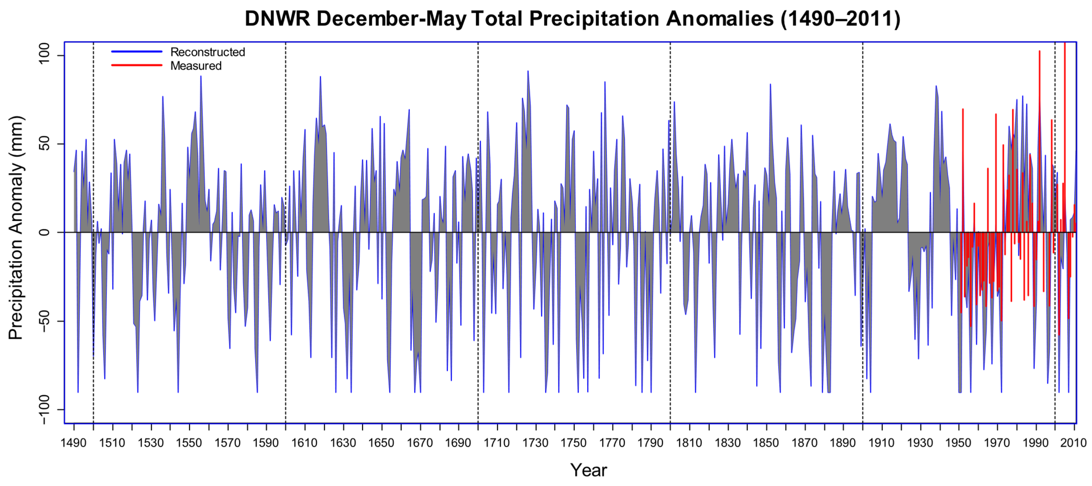
Exploratory data analysis relied on linear sample correlations of the Pine Nut and NevCAN tree-ring chronologies with the monthly, seasonal, and water-year total precipitation and mean air temperature. Partial correlations [35] and principal component regression with bootstrapped confidence intervals [36] were used to identify statistical relationships between tree-ring chronologies and climate variables. We used the Line of Organic Correlation (LOC) method [37] to perform our reconstruction. LOC has been used in various scientific applications with different names, including least areas regression, standardized major axis regression, least products regression, diagonal regression, and the Maintenance Of Variance Extension (MOVE) [38]. Its main advantage is that it generates reconstructed values with the cumulative distribution function, variance, and probabilities of extreme events that match those of the calibration dataset. Reconstruction performance was evaluated using calibration/validation statistics [39] also used for hydrological model assessment [40]. For instance, reduction of error, RE [39] (p. 333), is equivalent to the Nash–Sutcliffe efficiency, E [41]. Since regression was performed on time-series data, an additional evaluation measure was the Durbin–Watson statistic [42], which is based on the first-order autocorrelation of model residuals.
Instrumental and reconstructed time series were analyzed in terms of episodes above (or below) a fixed threshold [43,44]. In this approach, time-series intervals are quantified using their duration (or length), magnitude (or run-sum), intensity, and peak. Duration (D) is the number of time steps continuously above (or below) the threshold. Magnitude (M) is the sum of departures for a given episode duration. Intensity (I = M/D) is the average departure, or mean episode magnitude. Peak is the maximum absolute departure for a given episode. Using these parameters is a way to minimize subjectivity when identifying the “strongest, “greatest”, or “most remarkable” periods [44]. Because droughts, especially for long-term planning purposes, are evaluated using their duration and magnitude, we only used these two parameters. Ranking was conducted separately for the two parameters, and then each episode score was calculated as the sum of the two ranks: the higher the score, the stronger the episode. The approach we followed, albeit relatively simple, is well supported by advanced statistical theory [45,46].

3. Results

3.1. Climate and Tree Rings

Average climatic regime at the NevCAN site (Figure S3) showed essentially the same patterns that were reported for the Pine Nut site [13]. Since the Pine Nut and NevCAN tree-ring sites are located at the boundary between Nevada Climate Divisions 3 and 4, drought indices (PDSI and SPI-24; Figure 2 and Figure S4) were averaged prior to further analysis. From 1895 to 1999 (1260 months), SPI-24 episodes were fewer (71) and longer (mean duration of 17 months) than PDSI episodes (125 with mean duration of 10 months). However, this pattern changed from 2000 to 2024 (300 months) with about equal durations for both SPI-24 (24 episodes with a mean duration of 12 months) and PDSI (22 episodes with a mean duration of 13 months).
Because of sparse station coverage, the reliability of southern Nevada Climate Division data is relatively lower in its early decades [47], and therefore, our dendroclimatic calibration and reconstruction focused directly on the DNWR climatic records. Based on their normalized values, the total precipitation and mean temperature from 1950 to 2024, either monthly or for the water year (Figure S5), showed no long-term trend (p-value > 0.1). Correlations with the PRISM grid-cell data where the DNWR station is located were extremely high (average linear correlation of 0.93) for monthly, seasonal, and water-year time series during the period of overlap. Out of 768 months from 1950 to 2013, a total of 19 values were missing, of which 16 were for precipitation and 3 for temperature, with October being the most affected month (4 missing values). Imputations were performed prior to calculating bootstrapped principal component regression with tree-ring chronologies as predictands [36].
The tree-ring collection at the NevCAN site consisted of 20 stem increment cores collected from 12 trees (Table 1, Figure S6). Crossdating was greatly facilitated by comparing these core samples with the previously published dendrochronological data from the Pine Nut site [13], which, in turn, could be crossdated thanks to the availability of both increment core and fire-scar wedge samples. At both sites, the percentage of locally absent rings was extremely high (6.4%–6.7%; Table 1), and at the NevCAN site, two years were missing in every sample (year 1879 in 18 cores and year 2002 in 16 cores). In order to allow for enough replication (three samples or more per year), the tree-ring site chronology started in 1652 and ended in 2013 (362 years). The highly variable nature of the Sheep Range ponderosa pine ring widths was reflected in the overall chronology statistics (Table 1), which were very similar at both the Pine Nut and NevCAN sites, with high standard deviations, low first-order autocorrelations, and extremely high Gini coefficients.
The Sheep Range tree-ring chronologies (Pine Nut and NevCAN) showed inter-annual variability in synchrony with the two other ponderosa pine chronologies available from the south-central Great Basin (Figure S7). Pairwise linear correlations for overlapping periods between chronologies were very high (0.8–0.9), even though these ponderosa pine stands are located on mountain ranges far apart in linear distance (Figure 1). Thus, the period for the reconstruction could be extended back to 1490 CE by using the Pine Nut chronology alone to represent the Sheep Range. The main climatic signal during the 1951–2011 calibration period was cool-season (December through May) precipitation, as shown by statistical relationships with either monthly (Figure S8a) or aggregated (Table S1 and Figure S8b) climatic variables. Reconstruction skill using the Pine Nut tree-ring chronology and calibration/validation split periods (1951–1980 and 1981–2011) was supported by a greater than zero reduction of error (0.10) and coefficient of efficiency (0.03) and by the Durbin–Watson statistic (1.6), suggesting serially uncorrelated residuals.

3.2. Long-Term Dendroclimatic Patterns

The 522-year reconstruction (1490–2011 CE) of total December through May precipitation anomalies (mm) included a total of 197 episodes (Figure 3). The mean duration was 2.6 year, with the 99 positive (wet) episodes lasting slightly longer on average (3.1 year) than the 98 negative (dry) ones (2.2 year). The maximum drought duration was 11 years, from 1924 to 1934, corresponding to the well-known “Dust Bowl” period [48,49]. The longest episode also occurred in the 20th century, from 1905 to 1923 (19 year), which is another famous event throughout North America known as the “early 1900s pluvial” [50,51]. The ten strongest episodes in the entire reconstruction included seven wet and three dry spells (Table S2). Almost half of these episodes (4 total) occurred during the 20th century, making the 1900s a truly unusual climatic period. The strongest episode of all was the early 1900s pluvial, while the Dust Bowl drought was the fifth most extreme one. Given its establishment in 1936, the DNWR came into place following an extremely dry period (1924–1934) and right before an unusually wet one (1937–1945).
In the instrumental record, December through May precipitation from 1951 to 2024 accounted for an average 54% (range of 10%–95%) of the total water-year precipitation at the DNWR station. Using the same approach employed for the analysis of reconstructed episodes, the longest drought in the instrumental record was 6 years (1959–1964), i.e., only about half as long as our longest reconstructed drought. Of the 40 episodes that were identified, the 20 wet ones had shorter average duration (1.6 year) than the 20 dry ones (2.2 year), a value that was in close agreement with the average duration of our reconstructed droughts. The dry spell of 2012–2015, which stood out over the western USA for its intensity and duration—e.g., [52]—occurred right after the end of our reconstruction and was ranked as the fourth strongest episode in the DNWR instrumental record.

4. Discussion

Sky islands are unique ecosystems that were initially described for the “Madrean archipelago” of the southwestern USA and northwestern Mexico [53]. They appear when a continental or inland sequence of valleys and mountains is characterized by strong vertical gradients in environmental conditions that produce biogeographical zones that differ sharply with elevation so that the highest ecosystems emerge from the surrounding landscape as islands in the sea. About 20 such “sky island” complexes have now been recognized worldwide, including the Great Basin/Mojave Deserts one, which consists of a number of isolated mountains comparable to the Madrean region [4]. Ponderosa pine is a foundation species [54] in these habitats, and understanding its climatic response provides useful information to improve both its current management policies and its future performance projections.
The highly variable climatic conditions at our study sites were reflected in the tree-ring chronologies, as shown by their unusually high number of locally absent rings. Crossdating issues at the NevCAN site (Table 1) could be resolved thanks to the large number of samples available from the Pine Nut location, a nearby Sheep Range ponderosa pine stand that had been previously investigated [13]. The Pine Nut tree-ring chronology was derived from 31 crossdated samples, representing a combination of fire-scar wedge sections (16) and stem increment cores (15). That chronology, which ultimately was used for our precipitation reconstruction, was also checked for dating accuracy against not only two other ponderosa pine site chronologies (Table 1) but also an additional Sheep Range chronology developed by other investigators from white fir samples [28].
Cool-season, i.e., winter and spring, total precipitation emerged at the most relevant dendroclimatic signal. While this information is relevant for predicting climatic impacts on wood growth of these sky-island ponderosa pine populations, further research could investigate variability of latewood properties, which are typically connected with summer monsoon precipitation [55,56]. For the current study, it is worth emphasizing the very high degree of synchronicity among annual ring-width series (Figure S6), which is also reflected in very high (>0.8) mean inter-series correlations (MISC, Table 1) and is typically recognized as an indicator of climatically-influenced radial wood growth [27]. Because evaluating the suitability of dendrochronological data for climate reconstruction by means of the expressed population signal (EPS) has recently been criticized [57], we decided to list the MISC instead. This value, also called “rbar”, can then be used to calculate either the EPS, which is closely related to the signal-to-noise ratio, SNR [30], or the subsample signal strength, SSS [30].
Our 522-year-long reconstruction of December through May total precipitation anomalies for the DNWR used its own precipitation data for calibration and validation purposes. Publicly available instrumental climate records for the DNWR station are both quite long (>60 years) and with relatively few missing values (~2%). Differences in the average climatic regimes between the Sheep Range ponderosa pine sites and the DNWR station, which is about 20 km away and about 1300 m lower in elevation, could be largely accounted for by normalizing the data, thereby preserving the inter-annual variability while removing the differences in the means, which are mostly related to pronounced elevation gradients. Even though the DNWR records are shorter than both PRISM and climate division records, which both go back to January 1895, those spatially interpolated datasets have incorporated the high-elevation Snowpack Telemetry (SNOTEL) network, whose measurements begin in the early 1980s but were found to be affected by warming artifacts [58]. PRISM is a topographically driven interpolation algorithm, and climatic data used as input for the model do not undergo any time-discontinuity screening, either for records used at each time step, for urban heat island effects, for changes in station location, or for modified instrumentation. Because of this, PRISM output, albeit extremely useful in the spatial domain, should be avoided for time-series analysis or trend detection. Unfortunately, both climate division and PRISM time series are routinely used for climate change assessments—e.g., [59]—without mentioning such caveats.
Information derived from the past, such as tree-ring reconstructions of hydroclimatic variables requires careful consideration. On one hand, multi-century-long proxy time series broaden the perspective derived from much shorter instrumental records and from projections of future scenarios—e.g., [60]—particularly considering that regional climate model predictions have shown little skill outside of the tropical Pacific in non-ENSO years [61]. On the other hand, most reconstructions rely on statistical assumptions of linearity and stationarity. In this study, we therefore adopted the LOC method to generate more variable reconstructions than linear regression [62], as well as a quantitative analysis of time-series episodes to place modern patterns into a long-term framework.
The early-1900s pluvial, which was the strongest episode in our 522-year precipitation reconstruction, was found repeatedly to be the most remarkable episode during the past few centuries as well as throughout the Common Era [63]. As pointed out by other authors, this information is crucial to realize the extent of the “wet bias” that affects the instrumental record of hydroclimatic variables in the western USA [50,51]. Furthermore, that remarkable wet spell could be partially responsible for one of the longest fire-free intervals observed at the Pine Nut site, from 1862 to 1931 [13]. The stand-wide 1932 wildfire, which was the outermost crossdated fire scar at the Pine Nut site, could then have been favored by the extended Dust Bowl drought, although it is unclear if there is a climate connection with the even longer fire-free interval that followed, from 1933 to 2012 [13].
The Dust Bowl drought, which achieved top-ten status in the episode analysis presented here, was much less prominent (falling to the 73rd position) in a 2300-year precipitation reconstruction for the Walker River Basin, on the east slope of the Sierra Nevada [44]. We had previously reported [64] that regional drought severity in the Great Basin can differ depending on which portion of this region is being considered. With regard to the DNWR, our present study highlighted that current ponderosa pine populations in the Sheep Range have withstood drought periods over the past five centuries that were twice as long as the longest drought recorded in the instrumental record. While simulation models predict that, if air temperature increases, plant communities should migrate upslope [65], changes in precipitation could magnify or diminish that effect. Wood growth and tree species’ geographical ranges are both complex processes with multiple controlling factors, but it is plausible that ponderosa pine populations in the Sheep Range, given their tolerance to drought, may be able to avoid a forced upward progression.
In addition, recent climate suitability analyses have shown that future species distributions will likely be species and location specific and not be experienced uniformly across existing communities [66]. This prediction appears to be in agreement with global observations that species redistributions in mountain ecosystems largely fall within random expectations rather than following a consistent trend [67]. In fact, even in southwestern woodlands dominated by pinyon–juniper populations, the impact of multiple human activities, from wildfire suppression to land use changes, may have been overestimated with respect to intrinsic population growth dynamics [68]. The results we presented here ultimately address the needs of natural resource managers in these remote areas with respect to planning for “worst-case” scenarios of drought duration and magnitude. Therefore, DNWR land use policies should benefit from our quantitative representation of the range of extreme drought conditions that ponderosa pine populations on the Sheep Range are able to withstand.

Supplementary Materials

The following supporting information can be downloaded at: https://www.mdpi.com/article/10.3390/f16071142/s1, Figure S1: Fire-scarred ponderosa pines located at the Pine Nut site in the Sheep Range, Desert National Wildlife Refuge (DNWR), southern Nevada, USA (photo by J. Roberts); Figure S2: Ponderosa pines located at the NevCAN site in the Sheep Range, Desert National Wildlife Refuge (DNWR), southern Nevada, USA (photo by F. Biondi); Figure S3: Annual climatic regime (modified Walter–Lieth diagram) at the NevCAN site drawn using data from PRISM public domain data (see text for details); Figure S4: Time-series plot of seasonal and water-year drought indices for the two Nevada Climate Divisions that cover the tree-ring collection sites (see Figure 1); Figure S5: Time-series plot of monthly (gray lines) and water-year (blue bars) precipitation and air temperature for the DNWR station from 1950 to 2024; Figure S6: Time-series plot of annual, crossdated ring widths that were measured from 1652 to 2013 on 20 wood increment cores collected at the NevCAN site; Figure S7: Time-series plot from 1490 to 2013 of ponderosa pine tree-ring chronologies for south-central Nevada (see Figure 1 and Table 1); Figure S8: Bootstrapped principal component regression coefficients between the DNWR tree-ring chronology and climate variables recorded from 1951 to 2011 at a local station; Table S1: Linear partial correlations between tree-ring chronologies (Table 1) and December through May precipitation (“pcorr_Dec-MayPrec”) obtained while accounting for correlations with December through May air temperature; Table S2: The 10 strongest episodes identified in the 522-year reconstruction (1490–2011) of total December through May precipitation anomalies (mm; see Figure 3 for a time-series plot).

Author Contributions

Conceptualization, F.B. and J.R.; methodology, F.B.; software, F.B.; validation, F.B.; formal analysis, F.B.; resources, F.B. and J.R.; data curation, F.B.; writing—original draft preparation, F.B.; writing—review and editing, F.B. and J.R.; visualization, F.B.; supervision, F.B. and J.R.; project administration, F.B. and J.R.; funding acquisition, J.R. All authors have read and agreed to the published version of the manuscript.

Funding

This research was funded by the U.S. Department of the Interior, Fish and Wildlife Service Cooperative Agreement F23AC03050. F.B. was also funded, in part, by the Experiment Station of the College of Agriculture, Biotechnology, and Natural Resources at the University of Nevada, Reno.

Data Availability Statement

The raw data supporting the conclusions of this article will be made available by the corresponding author on request.

Acknowledgments

We thank Scotty Strachan for his help coordinating NevCAN field activities and Mackenzie Kilpatrick, Jehren Boehm, Charles Truettner, and Emanuele Ziaco for helping with DendroLab field work and with laboratory analyses of tree-ring samples.

Conflicts of Interest

The authors declare no conflicts of interest. The funders had no role in the design of the study; in the collection, analyses, or interpretation of data; in the writing of the manuscript; or in the decision to publish the results.

References

  1. Grayson, D.K. The Great Basin: A Natural Prehistory, Revised and Expanded ed.; University of California Press: Berkeley, CA, USA, 2011. [Google Scholar]
  2. Osmond, C.B.; Pitelka, L.F.; Hidy, G.M. (Eds.) Plant Biology of the Basin and Range; Springer: Berlin/Heidelberg, Germany, 1990; Volume 80. [Google Scholar]
  3. Dominguez, F.; Villegas, J.C.; Breshears, D.D. Spatial extent of the North American Monsoon: Increased crossregional linkages via atmospheric pathways. Geophys. Res. Let. 2009, 36, L07401. [Google Scholar] [CrossRef]
  4. Warshall, P. The Madrean sky island archipelago: A planetary overview. In Biodiversity and Management of the Madrean Archipelago: The Sky Islands of the Southwestern United States and Northwestern Mexico; DeBano, L.F., Ffolliott, P.F., Ortega-Rubio, A., Gottfried, G.J., Hamre, R.H., Edminster, C.B., Eds.; US Department of Agriculture, Forest Service, Rocky Mountain Forest and Range Experiment Station: Fort Collins, CO, USA, 1995; pp. 6–18. [Google Scholar]
  5. Charlet, D.A. Distribution patterns of Great Basin conifers: Implications of extinction and immigration. Aliso 2007, 24, 31–61. [Google Scholar] [CrossRef]
  6. Potter, K.M.; Hipkins, V.D.; Mahalovich, M.F.; Means, R.E. Mitochondrial DNA haplotype distribution patterns in Pinus ponderosa (Pinaceae): Range-wide evolutionary history and implications for conservation. Am. J. Bot. 2013, 100, 1562–1579. [Google Scholar] [CrossRef] [PubMed]
  7. Willyard, A.; Gernandt, D.S.; Potter, K.; Hipkins, V.; Marquardt, P.; Mahalovich, M.F.; Langer, S.K.; Telewski, F.W.; Cooper, B.; Douglas, C.; et al. Pinus ponderosa: A checkered past obscured four species. Am. J. Bot. 2017, 104, 161–181. [Google Scholar] [CrossRef]
  8. Allen, C.D.; Savage, M.; Falk, D.A.; Suckling, K.F.; Swetnam, T.W.; Schulke, T.; Stacey, P.B.; Morgan, P.; Hoffman, M.; Klingel, J.T. Ecological restoration of southwestern ponderosa pine ecosystems: A broad perspective. Ecol. Appl. 2002, 12, 1418–1433. [Google Scholar] [CrossRef]
  9. Margolis, E.Q.; Guiterman, C.H.; Chavardès, R.D.; Coop, J.D.; Copes-Gerbitz, K.; Dawe, D.A.; Falk, D.A.; Johnston, J.D.; Larson, E.; Li, H.; et al. The North American tree-ring fire-scar network. Ecosphere 2022, 13, e4159. [Google Scholar] [CrossRef]
  10. Parks, S.A.; Guiterman, C.H.; Margolis, E.Q.; Lonergan, M.; Whitman, E.; Abatzoglou, J.T.; Falk, D.A.; Johnston, J.D.; Daniels, L.D.; Lafon, C.W.; et al. A fire deficit persists across diverse North American forests despite recent increases in area burned. Nat. Commun. 2025, 16, 1493. [Google Scholar] [CrossRef]
  11. Kilpatrick, M.; Biondi, F.; Strachan, S.; Sibold, J.S. Fire history of mixed conifer ecosystems in the Great Basin/Mojave Deserts transition zone, Nevada, USA. Trees 2013, 27, 1789–1803. [Google Scholar] [CrossRef]
  12. Biondi, F.; Jamieson, L.P.; Strachan, S.; Sibold, J. Dendroecological testing of the pyroclimatic hypothesis in the central Great Basin, Nevada, USA. Ecosphere 2011, 2, 1–20. [Google Scholar] [CrossRef]
  13. Kilpatrick, M.; Roberts, J.; Biondi, F. Fire history of an old-growth ponderosa pine stand in the Sheep Range, Desert National Wildlife Refuge, Nevada, USA. Tree Ring Res. 2019, 75, 127–138. [Google Scholar] [CrossRef]
  14. Walker, R.B.; Coop, J.D.; Parks, S.A.; Trader, L. Fire regimes approaching historic norms reduce wildfire-facilitated conversion from forest to non-forest. Ecosphere 2018, 9, e02182. [Google Scholar] [CrossRef]
  15. Stephens, S.L.; Lydersen, J.M.; Collins, B.M.; Fry, D.L.; Meyer, M.D. Historical and current landscape-scale ponderosa pine and mixed conifer forest structure in the Southern Sierra Nevada. Ecosphere 2015, 6, 1–63. [Google Scholar] [CrossRef]
  16. McEvoy, D.J.; Mejia, J.F.; Huntington, J.L. Use of an observation network in the Great Basin to evaluate gridded climate data. J. Hydrometeorol. 2014, 15, 1913–1931. [Google Scholar] [CrossRef]
  17. Vose, R.S.; Applequist, S.; Squires, M.; Durre, I.; Menne, M.J.; Williams, C.N.; Fenimore, C.; Gleason, K.; Arndt, D. Improved historical temperature and precipitation time series for U.S. Climate Divisions. J. Appl. Meteorol. Clim. 2014, 53, 1232–1251. [Google Scholar] [CrossRef]
  18. US Western Regional Climate Center. Climate Data for DESERT NATL WL RANGE, NEVADA (262243). Available online: https://wrcc.dri.edu/cgi-bin/cliMAIN.pl?nv2243 (accessed on 14 April 2025).
  19. van Buuren, S.; Groothuis-Oudshoorn, K. Mice: Multivariate Imputation by Chained Equations in R. J. Stat. Softw. 2011, 45, 1–67. [Google Scholar] [CrossRef]
  20. Daly, C.; Halbleib, M.; Smith, J.I.; Gibson, W.P.; Doggett, M.K.; Taylor, G.H.; Curtis, J.; Pasteris, P.P. Physiographically sensitive mapping of climatological temperature and precipitation across the conterminous United States. Int. J. Climatol. 2008, 28, 2031–2064. [Google Scholar] [CrossRef]
  21. Diaz, H.F.; Wahl, E.R. Recent California water year precipitation deficits: A 440-year perspective. J. Clim. 2015, 28, 4637–4652. [Google Scholar] [CrossRef]
  22. Hipel, K.W.; McLeod, A.I. Time Series Modelling of Water Resources and Environmental Systems; Elsevier Science: Amsterdam, The Netherlands, 1994. [Google Scholar]
  23. McLeod, A.I. R Foundation for Statistical Computing: CRAN, Package ‘Kendall’. Available online: https://cran.r-project.org/web/packages/Kendall/index.html (accessed on 8 July 2025).
  24. Stokes, M.A.; Smiley, T.L. An Introduction to Tree-Ring Dating, Reprint of the 1968 ed.; University of Arizona Press: Tucson, AZ, USA, 1996. [Google Scholar]
  25. Grissino-Mayer, H.D. Evaluating crossdating accuracy: A manual and tutorial for the computer program COFECHA. Tree Ring Res. 2001, 57, 205–221. [Google Scholar]
  26. Bunn, A.G. Statistical and visual crossdating in R using the dplR library. Dendrochronologia 2010, 28, 251–258. [Google Scholar] [CrossRef]
  27. Speer, J.H. Fundamentals of Tree-Ring Research; University of Arizona Press: Tuscon, AZ, USA, 2010. [Google Scholar]
  28. Cropper, J.P.; Ferguson, C.W. Sawmill Canyon—ABCO—ITRDB NV506; NOAA/WDS Paleoclimatology; NOAA National Centers for Environmental Information: Silver Spring, MD, USA, 1978. [CrossRef]
  29. Cook, E.R.; Peters, K. The smoothing spline: A new approach to standardizing forest interior tree-ring width series for dendroclimatic studies. Tree Ring Bull. 1981, 41, 45–53. [Google Scholar]
  30. Wigley, T.M.L.; Briffa, K.R.; Jones, P.D. On the average value of correlated time series, with applications in dendroclimatology and hydrometeorology. J. Clim. Appl. Meteorol. 1984, 23, 201–213. [Google Scholar] [CrossRef]
  31. Holmes, R.L. Computer-assisted quality control in tree-ring dating and measurement. Tree Ring Bull. 1983, 43, 69–78. [Google Scholar]
  32. Biondi, F.; Qeadan, F. Inequality in paleorecords. Ecology 2008, 89, 1056–1067. [Google Scholar] [CrossRef] [PubMed]
  33. Bunn, A.G. A dendrochronology program library in R (dplR). Dendrochronologia 2008, 26, 115–124. [Google Scholar] [CrossRef]
  34. R Core Team. R: A Language and Environment for Statistical Computing; R Foundation for Statistical Computing: Vienna, Austria, 2021. [Google Scholar]
  35. Kim, S. Ppcor: An R package for a fast calculation to semi-partial correlation coefficients. Commun. Stat. Appl. Methods 2015, 22, 665–674. [Google Scholar] [CrossRef] [PubMed]
  36. Zang, C.; Biondi, F. treeclim: An R package for the numerical calibration of proxy-climate relationships. Ecography 2015, 38, 431–436. [Google Scholar] [CrossRef]
  37. Helsel, D.R.; Hirsch, R.M.; Ryberg, K.R.; Archfield, S.A.; Gilroy, E.J. Statistical Methods in Water Resources; USGS: Reston, VA, USA, 2020; p. 484.
  38. Salas, J.D.; Raynal, J.A.; Tarawneh, Z.S.; Lee, T.S.; Frevert, D.K.; Fulp, T.J. Extending Short Records of Hydrologic Data. In Hydrology and Hydraulics; Singh, V.P., Ed.; Water Resources Publications, LLC.: Highlands Ranch, CO, USA, 2008; pp. 717–760. [Google Scholar]
  39. Fritts, H.C. Tree Rings and Climate; Academic Press: London, UK, 1976. [Google Scholar]
  40. Krause, P.; Boyle, D.P.; Bäse, F. Comparison of different efficiency criteria for hydrological model assessment. Adv. Geosci. 2005, 5, 89–97. [Google Scholar] [CrossRef]
  41. Nash, J.E.; Sutcliffe, J.V. River flow forecasting through conceptual models, Part I—A discussion of principles. J. Hydrol. 1970, 10, 282–290. [Google Scholar] [CrossRef]
  42. Draper, N.R.; Smith, H. Applied Regression Analysis, 3rd ed.; Wiley: New York, NJ, USA, 1998. [Google Scholar]
  43. Salas, J.D. Analysis and modeling of hydrologic time series. In Handbook of Hydrology; Maidment, D.R., Ed.; McGraw-Hill: New York, NY, USA, 1992; pp. 19.01–19.72. [Google Scholar]
  44. Biondi, F.; Kozubowski, T.J.; Panorska, A.K.; Saito, L. A new stochastic model of episode peak and duration for eco-hydro-climatic applications. Ecol. Model. 2008, 211, 383–395. [Google Scholar] [CrossRef]
  45. Kozubowski, T.J.; Panorska, A.K. A mixed bivariate distribution connected with geometric maxima of exponential variables. Commun. Stat. Theory Methods 2008, 37, 2903–2923. [Google Scholar] [CrossRef]
  46. Kozubowski, T.J.; Panorska, A.K. A mixed bivariate distribution with exponential and geometric marginals. J. Stat. Plan. Inference 2005, 134, 501–520. [Google Scholar] [CrossRef]
  47. Guttman, N.B.; Quayle, R.G. A historical perspective of US climate divisions. Bull. Am. Meteorol. Soc. 1996, 77, 293–303. [Google Scholar] [CrossRef]
  48. Cook, B.I.; Seager, R.; Smerdon, J.E. The worst North American drought year of the last millennium: 1934. Geophys. Res. Lett. 2014, 41, 7298–7305. [Google Scholar] [CrossRef]
  49. Diaz, H.F. Drought in the United States: Some aspects of major dry and wet periods in the contiguous united states, 1895–1981. J. Clim. Appl. Meteorol. 1983, 22, 3–16. [Google Scholar] [CrossRef]
  50. Cook, B.I.; Seager, R.; Miller, R.L. On the causes and dynamics of the early twentieth-century North American pluvial. J. Clim. 2011, 24, 5043–5060. [Google Scholar] [CrossRef]
  51. Woodhouse, C.A.; Kunkel, K.E.; Easterling, D.R.; Cook, E.R. The twentieth-century pluvial in the western United States. Geophys. Res. Let. 2005, 32, L07701. [Google Scholar] [CrossRef]
  52. Biondi, F.; Meko, D.M. Long-term hydroclimatic patterns in the Truckee-Carson Basin of the eastern Sierra Nevada, USA. Water Resour. Res. 2019, 55, 5559–5574. [Google Scholar] [CrossRef]
  53. Gottfried, G.J.; Gebow, B.S.; Eskew, L.G.; Edminster, C.B. (Eds.) Connecting Mountain Islands and Desert Seas: Biodiversity and Management of the Madrean Archipelago II; US Department of Agriculture, Forest Service, Rocky Mountain Research Station: Fort Collins, CO, USA, 2005.
  54. Ellison, A.M.; Bank, M.S.; Clinton, B.D.; Colburn, E.A.; Elliott, K.; Ford, C.R.; Foster, D.R.; Kloeppel, B.D.; Knoepp, J.D.; Lovett, G.M.; et al. Loss of foundation species: Consequences for the structure and dynamics of forested ecosystems. Front. Ecol. Environ. 2005, 3, 479–486. [Google Scholar] [CrossRef]
  55. Morino, K.; Minor, R.L.; Barron-Gafford, G.A.; Brown, P.M.; Hughes, M.K. Bimodal cambial activity and false-ring formation in conifers under a monsoon climate. Tree Physiol. 2021, 41, 1893–1905. [Google Scholar] [CrossRef]
  56. Griffin, R.D.; Woodhouse, C.A.; Meko, D.M.; Stahle, D.W.; Faulstich, H.L.; Carrillo, C.; Touchan, R.; Castro, C.L.; Leavitt, S.W. North American monsoon precipitation reconstructed from tree-ring latewood. Geophys. Res. Lett. 2013, 40, 954–958. [Google Scholar] [CrossRef]
  57. Buras, A. A comment on the expressed population signal. Dendrochronologia 2017, 44, 130–132. [Google Scholar] [CrossRef]
  58. Oyler, J.W.; Dobrowski, S.Z.; Ballantyne, A.P.; Klene, A.E.; Running, S.W. Artificial amplification of warming trends across the mountains of the western United States. Geophys. Res. Lett. 2015, 42, 153–161. [Google Scholar] [CrossRef]
  59. Garfin, G.; Jardine, A.; Merideth, R.; Black, M.; LeRoy, S. (Eds.) Assessment of Climate Change in the Southwest United States: A Report Prepared for the National Climate Assessment; Island Press: Washington, DC, USA, 2013. [Google Scholar]
  60. Pederson, N.; Bell, A.R.; Knight, T.A.; Leland, C.; Malcomb, N.; Anchukaitis, K.J.; Tackett, K.; Scheff, J.; Brice, A.; Catron, B.; et al. A long-term perspective on a modern drought in the American Southeast. Environ. Res. Lett. 2012, 7, 014034. [Google Scholar] [CrossRef]
  61. Pielke, R.A., Sr.; Wilby, R.L. Regional climate downscaling: What’s the point? Eos Trans. Am. Geophys. Union 2012, 93, 52–53. [Google Scholar] [CrossRef]
  62. Hirsch, R.M. A comparison of four streamflow record extension techniques. Water Resour. Res. 1982, 18, 1081–1088. [Google Scholar] [CrossRef]
  63. Robeson, S.M.; Maxwell, J.T.; Ficklin, D.L. Bias correction of paleoclimatic reconstructions: A new look at 1,200+ years of Upper Colorado River Flow. Geophys. Res. Lett. 2020, 47, e2019GL086689. [Google Scholar] [CrossRef]
  64. Biondi, F. Dendroclimatic reconstruction at km-scale grid points: A case study from the Great Basin of north America. J. Hydrometeorol. 2014, 15, 891–906. [Google Scholar] [CrossRef]
  65. Kupfer, J.A.; Balmat, J.; Smith, J.L. Shifts in the potential distribution of sky island plant communities in response to climate change. In Connecting Mountain Islands and Desert Seas: Biodiversity and Management of the Madrean Archipelago II; Gottfried, G.J., Gebow, B.S., Eskew, L.G., Edminster, C.B., Eds.; US Department of Agriculture, Forest Service, Rocky Mountain Research Station: Fort Collins, CO, USA, 2005; pp. 485–490. [Google Scholar]
  66. Thomas, K.A.; Stauffer, B.A.; Jarchow, C.J. Decoupling of species and plant communities of the U.S. Southwest: A CCSM4 climate scenario example. Ecosphere 2023, 14, e4414. [Google Scholar] [CrossRef]
  67. Chen, Y.-H.; Lenoir, J.; Chen, I.-C. Limited evidence for range shift–driven extinction in mountain biota. Science 2025, 388, 741–747. [Google Scholar] [CrossRef]
  68. Shriver, R.K.; Pletcher, E.; Biondi, F.; Urza, A.K.; Weisberg, P.J. Long-term tree population growth can predict woody encroachment patterns. Proc. Nat. Acad. Sci. USA 2025, 122, e2424096122. [Google Scholar] [CrossRef]
Figure 1. Map showing the location of the Desert National Wildlife Refuge and of the four dendrochronological collection sites (red dots: Pine Nut/NevCAN, Mt. Irish, Clover Mtns.) with respect to Nevada Climate Division boundaries (blue lines). The Pine Nut and NevCAN sites are about 600 m apart in linear distance but within separate ponderosa pine stands on the Sheep Range, near the boundary between Climate Division 3 (NV3) and 4 (NV4).
Forests 16 01142 g001
Figure 2. Time-series plot of monthly drought indices (PDSI: Palmer Drought Severity Index; SPI-24: Standardized Precipitation Index over 24 months) for Nevada Climate Divisions 3 (NV 3) and 4 (NV 4).
Forests 16 01142 g002
Figure 3. Time-series graph of total precipitation from December through May reconstructed (blue line) using the LOC method (see text for details) during the 1490–2011 CE period. Deviations (=anomalies, in mm) above and below the zero reference line (gray shading) defined a total of 197 episodes, 99 positive (=wet) and 98 negative (=dry). Recorded values at the DNWR station from 1951 to 2011 were also centered and plotted (red lines).
Forests 16 01142 g003
Table 1. Summary of tree-ring data for four ponderosa pine sites located in central and southern Nevada, with both dating * and chronology ** information.
SiteFirst
Year
Last
Year
Dated
Trees/
Cores
MSL
(Years)
Dated
LAR/
Total
Period
with
N ≥ 3
Length
(Years)
MISCGSt. Dev.A1
NevCAN1629201312/20276354/55121652–20133620.870.310.520.29
Pine Nut #1206201118/31285593/88281490–20115220.850.280.470.29
Mt. Irish ##1363200311/21457155/95961396–20036080.870.170.300.27
Clover Mtns. ###1470200727/47314213/14,7431485–20075230.830.190.330.35
* Statistics independent of the standardization formula: MSL = mean segment length; LAR/total = number of locally absent rings/number of rings measured; N = number of measured samples per year; length = number of years with enough (in this case, three or more) measured samples per year. ** Statistics that depend on the standardization formula: MISC = mean inter-series correlation; G = Gini coefficient; St. Dev. = standard deviation; A1 = first-order autocorrelation. # Details on this tree-ring chronology were provided by Kilpatrick, et al. [13]. ## Details on this tree-ring chronology were provided by Biondi, et al. [12]. ### Details on this tree-ring chronology were provided by Kilpatrick, et al. [11].
Disclaimer/Publisher’s Note: The statements, opinions and data contained in all publications are solely those of the individual author(s) and contributor(s) and not of MDPI and/or the editor(s). MDPI and/or the editor(s) disclaim responsibility for any injury to people or property resulting from any ideas, methods, instructions or products referred to in the content.

