Article

Vulnerability and Adaptation of Coastal Forests to Climate Change: Insights from the Igneada Longos Forests of Türkiye

1
Department of Forest Engineering, Faculty of Forestry, Bartın University, Bartın 74100, Türkiye
2
Department of Marine Environment, Institute of Marine Sciences and Management, Istanbul University, Istanbul 34134, Türkiye
*
Author to whom correspondence should be addressed.
Forests 2025, 16(6), 976; https://doi.org/10.3390/f16060976
Submission received: 29 April 2025 / Revised: 27 May 2025 / Accepted: 4 June 2025 / Published: 10 June 2025

Abstract

As one of Europe’s rare floodplain forest ecosystems, the İğneada Longos Forests face increasing ecological pressures; this study examines land use and land cover (LULC) changes in the İğneada Longos Forests, a protected national park in Turkey, between 1984 and 2014, while also assessing future climate change impacts under different shared socioeconomic pathways (SSPs). In this context, the MaxEnt model, which exhibits a very high sensitivity, was used to determine the land use/land change and the change in natural distribution habitats of the forest tree species in the İğneada Longos Forests, which constitute the research area, due to the effects of climate change. The analysis of forest management plans revealed significant LULC shifts, including wetland loss, cropland expansion, and declines in pioneer tree species, such as the lowland maple and the European ash, due to anthropogenic pressures and increasing droughts. Climate modeling using the Emberger and De Martonne indices projected severe aridity by 2100, with Mediterranean climate dominance expanding (up to 89.25% under SSP3–7.0) and humid zones disappearing. These changes threaten biodiversity, carbon sequestration capacity, and ecosystem stability, particularly in floodplain forests, which are critical for carbon storage. The findings underscore the urgent need for adaptive conservation strategies, stakeholder collaboration, and climate-resilient forest management to mitigate ecological degradation and sustain ecosystem services under escalating climate stress.

1. Introduction

Coastal forests are critical ecotones that serve as transitional zones between highland forests and lowland marshes. These ecosystems are characterized by a gradient of plant species, with salt-tolerant species dominating the coastal side and salt-intolerant species prevalent on the landward side of the transition zone. However, these ecotones are increasingly threatened by climate change and other environmental stressors, such as rising sea levels, saltwater intrusion, and human activities [1,2,3]. The unique biodiversity and ecological functions of coastal forests make them vital for carbon sequestration, habitat provision, and coastal protection, yet their vulnerability to environmental changes poses significant challenges for conservation and management.
Hydrology, drought, agricultural expansion, and coastal land development are key factors influencing the distribution and health of coastal forests [4]. In transition zones, which typically run parallel to coastlines or river corridors, the inland migration of coastal dunes due to rising water levels has led to increased tree mortality. This phenomenon is particularly pronounced in areas where coastal forests form a critical component of the ecotone, often with poorly defined temporal boundaries [4,5]. The encroachment of saltwater into freshwater systems, exacerbated by sea-level rise, has been widely documented as a major driver of ecological change [6,7,8,9]. While mature trees may persist for decades under these stressors, prolonged exposure to elevated climate change conditions and other environmental pressures eventually leads to ecosystem degradation [10].
In many regions, coastal ecotones have already begun to migrate inland as a response to exceeding their tolerance limits. This shift is driven by a combination of factors, including higher temperatures, salt intrusion, dune movement, and anthropogenic activities such as urbanization and land-use changes [11,12,13]. However, the extent of this migration is often constrained by topographic barriers and human infrastructure, creating complex dynamics that are not yet fully understood. The interplay between natural processes and human interventions raises critical questions about the future of these ecosystems and their ability to adapt to ongoing environmental changes [14,15]. In addition, coastal forests are vital ecotones that connect terrestrial and aquatic ecosystems within their geographical basin and play a critical role in preserving biodiversity, carbon sequestration, and coastal protection [16]. Located in transitional zones between highland forests and lowland marshes, coastal forests are particularly sensitive to climate change, which can alter species composition and ecosystem dynamics [17]. In the context of their surrounding basins, these forests face additional pressures from human activities such as land development and agriculture, further exacerbating their susceptibility to environmental stressors [18].
Understanding the role of climate in shaping biogeography is essential for predicting the future of coastal forests. Local vegetation is often considered the best indicator of regional climate, and climatic zone classifications can provide valuable insights into the drivers of ecosystem change [19]. However, existing biome and ecosystem classification maps are limited in their ability to capture the nuanced impacts of climate change on biodiversity. The IPCC (Intergovernmental Panel on Climate Change) [20] has highlighted that 85% of observed changes in natural systems are attributable to climate change, underscoring the urgency of addressing this issue. Despite increasing evidence that climate change causes ecosystem restructuring and biodiversity loss, our future predictions of the impacts of climate change at the basin scale remain incomplete in terms of the ecosystem context [21]. Therefore, understanding the interplay between climate change and the ecological processes within coastal forest basins is essential for predicting future changes and developing effective conservation strategies [13]. The IPCC plays a critical role in addressing the complex challenges at the interface of climate science and policy-making. In the past and present study reports published by the IPCC, some scenarios have been created to evaluate the impacts that have been and will be caused by climate change [20,22,23,24]. As one of these, the SSPs (shared socioeconomic pathways) included in the Sixth Evaluation Report offer five different approaches with different world predictions, and they are divided into different subgroups according to their radiative forcing values. The following greenhouse gas emission scenarios have been reported, i.e., sustainability/green path, very low (SSP1–1.9) and low (SSP1–2.6); middle path, medium level (SSP2–4.5); regional competition/bad path, high (SSP3–7.0); and intensive use of fossil fuels/development path, very high (SSP5–8.5) [22]. SSPs are designed to identify different socioeconomic development pathways and their impacts on climate change. In addition, projection trends of key climate parameters such as temperature and precipitation can be monitored to understand the prevailing climate characteristics in the future. Projections serve as a crucial tool in drought prediction, as shifts in precipitation patterns and rising temperatures exert increasing pressure on water resources, particularly in regions with coastal forests.
Coastal ecosystems are influenced by a number of factors (Figure 1), some of which have direct (primary) effects, while others exert indirect (secondary) effects on plant and animal communities [25]. Forests in watersheds containing coastal ecosystems are generally composed of a mixture of deciduous and evergreen trees. These ecosystems also provide a critical habitat for uniquely differentiated forest species, storing significant amounts of carbon. However, deviations from species-specific environmental optima can lead to reduced tree growth, increased stress, and eventually, to mortality if adverse conditions persist [26,27]. Changes in climatic conditions specific to tree species in these watersheds, especially changes in temperature and precipitation patterns, will further alter the phenology and resilience of trees in coastal ecotones [28,29,30]. For example, increasing temperatures and changes in hydrology are increasing tree stress in some areas of the basin [5].
To date, oceans have played a vital role in balancing the effects of global warming by absorbing approximately 25%–30% of excess atmospheric carbon [31]. This process operates through two main mechanisms: physical dissolution and biological pump. In physical dissolution, atmospheric CO2 dissolves in water at the ocean surface and turns into carbonic acid (CO2 + H2O ↔ H2CO3); this reaction occurs within the framework of Henry’s law. In the biological pump, the carbon captured by phytoplankton through photosynthesis is transported to the ocean depths as particulate organic carbon (POC) and can be stored there for thousands of years. According to the study of Sabine et al. [31], it is estimated that the oceans absorbed 118 ± 19 Pg C carbon between 1800 and 1994 alone. However, in recent years, serious decreases in this carbon absorption capacity have been observed due to processes such as ocean acidification, increase in sea water temperatures, and eutrophication. This further highlights the balancing role of land-based ecosystems, especially wetlands, in the carbon cycle. In this context, floodplain forests are special land systems that develop in water-saturated and oxygen-limited conditions throughout the year, similar to mangrove ecosystems. This environmental structure ensures the continuity of anaerobic conditions in the soil. Since the decomposition activities of microorganisms slow down significantly in oxygen-free environments, organic matter remains intact in the soil for a long time. Thus, carbon accumulates in the soil in layers in the form of organic matter and its re-release into the atmosphere is delayed. This process makes these ecosystems powerful carbon sinks.
Research demonstrates that mangrove forests can store an average of 956 tons of biomass carbon and 583 tons of soil carbon per hectare, with annual carbon deposition rates reaching 6–8 tons of CO2 equivalent per hectare [30]. A prominent example of high carbon storage is found in the peat swamp forests of the Congo Basin, which are estimated to contain approximately 30.6 billion tons of carbon—accounting for nearly 28% of the global tropical forest carbon stock [31]. Carbon accumulation capacity varies significantly among floodplain forest ecosystems. Areas that remain permanently saturated maintain anaerobic soil conditions, which slow down decomposition processes and enable more stable, long-term carbon storage. Conversely, in seasonally flooded regions, periodic drying and oxygenation accelerate decomposition, facilitating the release of stored carbon into the atmosphere. For instance, studies in Amazonian várzea forests have shown that carbon accumulation in permanently waterlogged zones is 35%–50% higher compared to that in seasonally flooded areas. Ecosystems such as mangroves, peatlands, and floodplain forests not only store significant amounts of carbon but also have the capacity to provide long-term carbon insulation, retaining carbon in soils for millennia. However, the degradation or desiccation of these systems—whether due to anthropogenic pressures or climatic shifts—can rapidly reverse this process, releasing previously sequestered carbon and thereby accelerating climate change [32]. This risk is particularly acute under scenarios of prolonged drought, where the release of soil carbon becomes a critical concern. Land use and land cover (LULC) change represents a major threat to the carbon storage functions of these sensitive ecosystems [33]. The conversion of wetlands to agricultural land, infrastructure development, and other forms of human disturbance often involve drainage, deforestation, and soil disruption—activities that compromise the anaerobic conditions essential for long-term carbon storage [34]. In addition, climate-induced changes in precipitation and temperature are expected to alter species distributions and ecosystem functions, further weakening carbon sequestration capacities [35]. In the İğneada Longos Forests, historical LULC changes prior to the area’s designation as a national park—such as wetland loss and shifts in species composition—have likely diminished the region’s ability to act as a carbon sink [36]. When such land cover changes are coupled with increasing drought frequency and intensity, as projected in future climate scenarios, the compounded effects may lead to substantial soil carbon losses. This not only undermines local ecological resilience but also poses a significant obstacle to broader climate change mitigation efforts.
This study presents a comprehensive case analysis of the İğneada Longos Forests, one of Turkey’s most ecologically significant coastal forest ecosystems, to evaluate the impacts of climate change and anthropogenic pressures over time. The primary objective is to assess the long-term ecological and climatic vulnerabilities by examining changes in land use and species composition based on historical and contemporary forest management plans—specifically the current forest management plans (FMPs). Utilizing GIS-based spatial analyses and climate classification methods, such as the De Martonne and Emberger indices, the study also projects how future climate change scenarios may influence the structure and function of the floodplain forests and the broader basin. In doing so, it seeks to elucidate the mechanisms driving ecological change and to propose adaptive strategies to mitigate the adverse effects of increasing drought, land conversion, and climatic variability. By emphasizing the role of floodplain forests in biodiversity conservation, carbon sequestration, and climate regulation, the study contributes to the development of integrated, climate-resilient forest management practices. The findings have significant implications for conservation policy and underscore the urgency of ecosystem-based adaptation approaches to safeguard coastal forest landscapes and the critical services they provide.

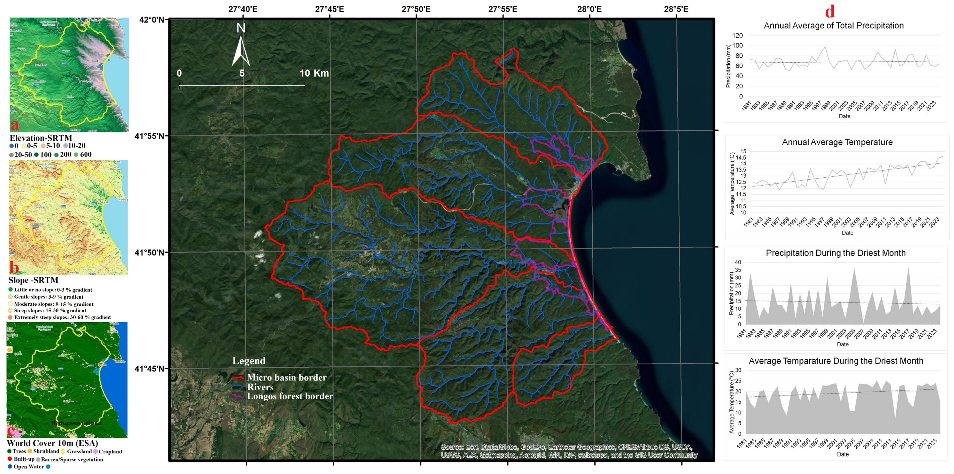
2. Materials and Methods

Ecotones, which are divided into four spatial hierarchical locales, i.e., micro (vegetation), meso (population types), macro (landscape and patch), and mega (biome), are elements that affect climate, microclimate, topography, micro-topography, soil character, soil chemistry, soil fauna, soil microflora, biological vectors, species interaction, physiological control, and genetic limitation [37]. The most appropriate area to evaluate these elements at regional and local scales within the ecosystem as a whole is the geographical basin [38]. In this study, the selected study area is the sub-basin that includes five micro-basins responsible for hydrologically sustaining the İğneada Longos Forests, one of the region’s key ecotones.
The study area encompasses the İğneada Longos Forests, comprising five micro-basins, and is situated in the Thrace Region of northwestern Turkey. It lies along the Black Sea coast within Kırklareli Province, near the Turkey–Bulgaria border, between approximately 41°05′ N latitude and 27°06′ E longitude. Situated at the foothills of the Istranca Mountains, the study area encompasses a diverse landscape shaped by rural settlements, small-scale agriculture, forestry-based livelihoods, and seasonal tourism. With low population density and limited economic diversification, local communities rely heavily on natural resources through subsistence farming, livestock grazing, and fishing. Although the region remains relatively underdeveloped, it has experienced increasing land-use pressures from agricultural expansion, infrastructure development, and tourism, which have threatened the ecological integrity of the forests. While these pressures have decreased since the area was designated as a national park in 2007, they have not been fully eliminated. The İğneada Longos Forests, which are seasonally inundated during winter and spring, represent one of Turkey’s most significant coastal carbon sink ecosystems. The study focused on five micro-basins that maintain the hydrological continuity of the Longos system, delineating the sub-basin boundaries for analysis. Recognized as one of Turkey’s 122 Important Plant Areas [34], the region supports a wide range of vegetation types—including 4 endemic, 12 rare, and 55 medicinal plant species—across wetland forests, peatlands, marshes, dune plant communities, riverbank meadows, and lagoons. Covering an area of approximately 3156 hectares, the İğneada Longos Forests include 2119 hectares of natural floodplain forest, 113 hectares of coastal dunes, and 34 hectares of lagoon lakes, as well as marsh and coastal ecosystems, reflecting a rich mosaic of ecological diversity and conservation value [36].
The study area displays a long-term (1970–2024) average air temperature and annual precipitation of 13.09 °C and 817.7 mm, respectively. The dominant and co-dominant forest tree species of the natural forest lands in the research area are the Hungarian lowland maple (Quercus frainetto Ten.), English lowland maple (Quercus robur subsp. robur L.), sessile lowland maple (Quercus petraea subsp. petraea (Mattuschka) Liebl.), Turkey lowland maple (Quercus cerris L.), Oriental beech (Fagus orientalis Lipsky.), European hornbeam (Carpinus betulus L.), Eurasian aspen (Populus tremula L.), and Oriental hornbeam (Carpinus orientalis Mill.) [39,40]. These broad-leaved forest tree species naturally found in natural forests in the research area generally exhibit the characteristics of single-layered and even-aged stand formation in the nature of high forests. In addition, there are also structures with the characteristics of coppice forests originated from roots and stump shoots of forests consisting of pure and mixed lowland maple species and Oriental beech (Fagus orientalis Lipsky.) in the research area. These coppice forests in question generally exhibit the characteristics of single-layered and even-aged stand structure. Furthermore, there are forest tree species such as the European field elm (Ulmus minor Miller), European white elm (Ulmus leavis Pall.), field maple (Acer campestre L.), common alder (Alnus glutinosa subsp. glutinosa (L.) Gaertn.), narrow-leaved European ash (Fraxinus angustifolia subsp. oxycarpa Vahl.), mountain European ash (Sorbus aucaparia L.), silver linden (Tilia tomentosa Moench.), and Black Sea walnut (Juglans regia L.) in the riparian zones [39,40]. In addition, in the floodplains in the research area, there is a generally even-aged, single-layered forest structure consisting of species such as the English lowland maple (Quercus robur subsp. robur L.), sessile lowland maple (Quercus petraea subsp. petraea (Mattuschka) Liebl.), Turkey lowland maple (Quercus cerris L.), Oriental beech (Fagus orientalis Lipsky.), European hornbeam (Carpinus betulus L.), field maple (Acer campestre L.), common alder (Alnus glutinosa subsp. glutinosa (L.) Gaertn.), narrow-leaved European ash (Fraxinus angustifolia subsp. oxycarpa Vahl.), mountain European ash (Sorbus aucaparia L.), and silver linden (Tilia tomentosa Moench.) [39,40]. Additionally, Sea Daffodil (Pancratium maritimum L.), Butcher’s Broom (Ruscus aculeatus L.), Sea Kale (Crambe maritima L.), Sumer Snowflake (Leucojum aestivum L.), Snowdrop (Galanthus nivalis subsp. Nivalis L.), Himalayan Thomless Thistle (Jurinea kilaea Azn.), Sand Knapweed (Centaurea arenaria M.Bieb. ex Willd.), Water Chesnut (Trapa natans L.), Horned Orchid (Ophrys oestifera MBieb.), Sycamore Maple (Acer pseudoplatanus L.), Basket-of-Gold (Aurinia uechtritziana L.), King Herb (Peucedanum obtusifolium L.), German (Polycnemum verrucosum L.), Starthistles (Centaurea kilaea Boiss.), Sand-Flockenblume (Centauera arenaria M.Bieb. ex Willd.), Sangaria Catchfly (Silene sangaria Coode & Cullen), Sand Stock (Matthiola fruticosa (L.) Maire), Sea Kale (Crambe maritima L.), Capitate Galingale (Cyperus capitatus Vand.), Sea Holly (Eryngium maritimum L.), Mammoth Wild Rye (Leymus racemosus (Lam.)), Windwitch (Salsola tragus L.), Cocklebur (Xanthium strumarium subsp. Cavanillesii L.), Tall Wheatgrass (Elymus elongatus subsp. Elongatu L.), Robbit-Tobacco (Peucedanum obtusifolium (L.) Hilliard & B.L. Burt), and Milkweed (Cionura erecta L. Griseb.) species are found in the coastal dunes in the research area (Figure 2) [39,40,41].
Figure 2 presents the study area, along with maps of elevation, slope, land use/land cover (LULC), and trends in precipitation and temperature, all of which were generated using EarthMap [42]. This figure provides an overview of the study area and includes baseline data supporting the study’s primary objectives. Elevation and slope data were derived from the Shuttle Radar Topography Mission (SRTM) [43], indicating that the average elevation of the study area is approximately 200 m (Figure 2a). According to slope classification, the area falls into the “moderate” grazing suitability class. Within the protected boundaries of the İğneada Longos Forests, elevations range from 0 to 100 m, and the slope is categorized as “little or no slope” (Figure 2b). Land use/land cover information was obtained from ESA WorldCover data, with a 10 m spatial resolution [44]. The broader study basin is predominantly classified under the “Trees” category, indicating a dense forest cover (Figure 2c). Within the İğneada Longos Forests, the dominant LULC classes are “Open Water” and “Trees”. Using the EarthMap platform, temporal trend analyses for precipitation and temperature were conducted based on ECMWF ERA5 data for the 1981–2024 period [45]. While total annual precipitation in the basin has shown minimal variation over time, average temperatures have increased by approximately 1.8 °C. Notably, the trend analysis for the driest months indicates a decline in precipitation and a concurrent rise in temperature (Figure 2d). These climatic trends constitute the core focus of the study as they pertain to the İğneada basin and its sensitive floodplain forest ecosystem.
In this study, in the sub-basin study area covering İğneada Longos Forests, one of the important ecotones, changes in regards to possible stress factors depending on temperature and precipitation parameters were investigated. MaxEnt 3.4.1, which uses the maximum entropy principle, was used to estimate a series of functions related to ecological and potential geographical distribution in modeling the current and potential distribution areas of climate types belonging to the study area, and ArcGIS 10.8 software was used for map displays [46]. Based on detailed and comparative information on these modeling and model approaches [47], the Max.Ent.3.4.1 algorithm, which is based on a combination of variables and allows for more precise and accurate spatial change calculations by including the De Martonne and Emberger indices [48]—widely used all over the world—in the analyses to determine the spatial changes that may occur due to climate change, was used in the analyses within the scope of the research [49,50]. The Max.Ent.3.4.1 model, one of the ecological niche models (ENMs), was created and used in the R statistical package program. Many scientific model approaches and indices are widely used to objectively reveal the effects of global climate change or to determine the possible effects of global warming and natural habitat changes on species or spatial changes. However, the most widely used of these indices are the De Martonne and Emberger indexes. The De Martonne Drought Index (DMI) determines the drought level of the region according to the annual average temperature and precipitation. About a hundred years ago, the De Martonne Bioclimatic Index (DMI) was proposed to assess the degree of aridity of a given environment by classifying it into seven classes from “dry” to “extremely humid”, based on basic climatic parameters such as air temperature and precipitation. The DMI has been widely used for bioclimate classification due to its reliability, effectiveness, and validity. Scientific research that frequently uses the DMI falls into the fields of climatology/bioclimatology, agriculture, and land or water resource management, while the index also appears to be a useful tool for obtaining environmental assessment reports [51,52]. It is very effective in determining the water stress and drought risk regions in order to understand the adequacy of water resources. Since changes in precipitation patterns and temperature increases with climate change put pressure on water resources, this index is an important tool for making drought predictions. The Emberger Drought Index takes into account the humidity status and temperature balance of the region. The Emberger Index (EI), commonly defined as the “plutothermic coefficient Q”, categorizes the bioclimatic zones of the Mediterranean region according to a scheme ranging from “per-humid” to “per-arid” bioclimatic or bioclimatic category, based on temperature, precipitation, and evaporation parameters. For the EI projections, the annual temperature is represented by the mean maximum temperature of the hottest month (M) and the mean minimum temperature of the coldest month (m), since vegetation growth depends on these thermal limits. Precipitation (P) is expressed on an annual basis. At the same time, evaporation is represented indirectly by the difference between the two temperature values (M-m), since EI increases with the latter parameter. Furthermore, by applying a simplified algorithm based on the minimum winter temperature (m), which falls within the range of “very warm” to “very cold” temperature characterizations, it serves the purpose of phytoclimatic classification into bioclimatic subtypes, often referred to as “Q2”. Therefore, the phytoclimatic footprint of an area is characterized by combining bioclimatic characterization types derived from estimates of Q values with temperature conditions based on estimates of m values, resulting in Emberger’s Q2 bioclimatic subtypes, e.g., a Q2 subtype of “semi-arid, temperate winter” [51,52]. In addition, the De Martonne and Emberger indices are useful in analyzing climate changes at the local level. In particular, in order to evaluate the effects of climate change in certain regions in more detail, the calculation of these indices provides information such as which regions experience more water stress and are at risk of drought. In addition, since these indices provide practical and comparable results in practice, they are useful for evaluating and comparing drought conditions between different regions or time periods. They are especially useful for researchers and climate experts looking for a simpler and faster method compared to complex climate models. For all these scientific reasons and in line with the realization of the scientific goals and objectives of the research, the De Martonne and Emberger and climate indices were used in the study.
For the assessment of the bioclimatic conditions of the cross-section area, the the De Martonne index (DMI) was applied and computed on an annual basis according to the following formula [51]:
D M I = P 10 + T
where:
  • P is the annual precipitation (mm);
  • T is the annual average air temperature (°C);
  • The number 10 is the coefficient employed for the acquisition of positive values.
The Emberger index (EI), commonly termed the “pluviothermic quotient” (Q or Q1), was applied and computed on an annual basis according to the following formula [51]:
E I = Q = 100 × M + m 2 × M m             Q = 200 × P M 2 m 2
where:
  • P represents the annual average precipitation (mm);
  • M represents the average maximum monthly air temperature of the warmest month in absolute degrees (K);
  • m represents the average minimum monthly air temperature of the coldest month in absolute degrees (K).
The relationship of the DMI and EI values with the bioclimate’s types and description are given Table 1.
In the study, climate data for the years 1970–2024 were used in the calculations made according to four different climate scenarios for four different periods using the De Martonne and Emberger indices. The climate data used in the calculations were obtained from the digital databases of Climate Data [53], WorldClim [54], and the Turkey General Directorate of Meteorology [55].
ROC (receiver operating characteristic) and AUC (area under the curve) values were used in the validation of the models. Probabilistic classifiers such as the MaxEnt models estimate the probability of belonging to a class. ROC and AUC values are used to make performance evaluations for such outputs [56,57]. AUC and ROC values are calculated and used to measure how well the model distinguishes between positive and negative classes; to provide a fair performance criterion, even if there is an imbalance between classes; to determine the correct threshold value; and to identify the general accuracy curve of the model [58]. When using the MaxEnt (maximum entropy) model for species distribution or ecological niche modeling, the AUC (area under the receiver operating characteristic curve) is a standard metric used to evaluate model performance. The AUC is important for MaxEnt models [59] because it provides a single-number summary of the model’s ability to discriminate between presence and background (or pseudoabsence) locations. A higher AUC indicates better discrimination [60]. Unlike some other metrics, the AUC does not depend on a specific threshold for classification. This makes it especially useful when the true presence–absence threshold is unclear. In this context, AUC = 0.5, the model is no better than random; AUC > 0.7, fair performance; AUC > 0.8, good; and AUC > 0.9, excellent for the interpretability of the models. In addition to this, the AUC allows for comparison between different models or configurations (e.g., different feature classes or regularization parameters in MaxEnt) [61,62].
In this study, the ROC and AUC values were calculated to determine the performance criterion [63] of the precipitation and temperature variables evaluated to reveal the effects of climate change in four different time periods, to reveal threshold values related to land change in different scenario models, and to determine the sensitivity and general accuracy levels of models made and applied separately according to the De-Martonne and Emberger drought indices [64]. For this purpose, the closest positive and negative values calculated by taking into account the natural vegetation cover in land change, according to the De Martonne and Emberger indices in terms of precipitation and temperature variables and the estimated probability values obtained from the models, were comparatively evaluated [65]. Four different time periods (2040, 2060, 2080, and 2100) were examined for four scenarios (SSPs1–2.6, SSPs2–4.5, SSPs3–7.0, and SSPs5–8.5), representing the concentration of greenhouse gases and pollutants resulting from human activities, according to the Sixth Assessment Report [66].

3. Results and Discussion

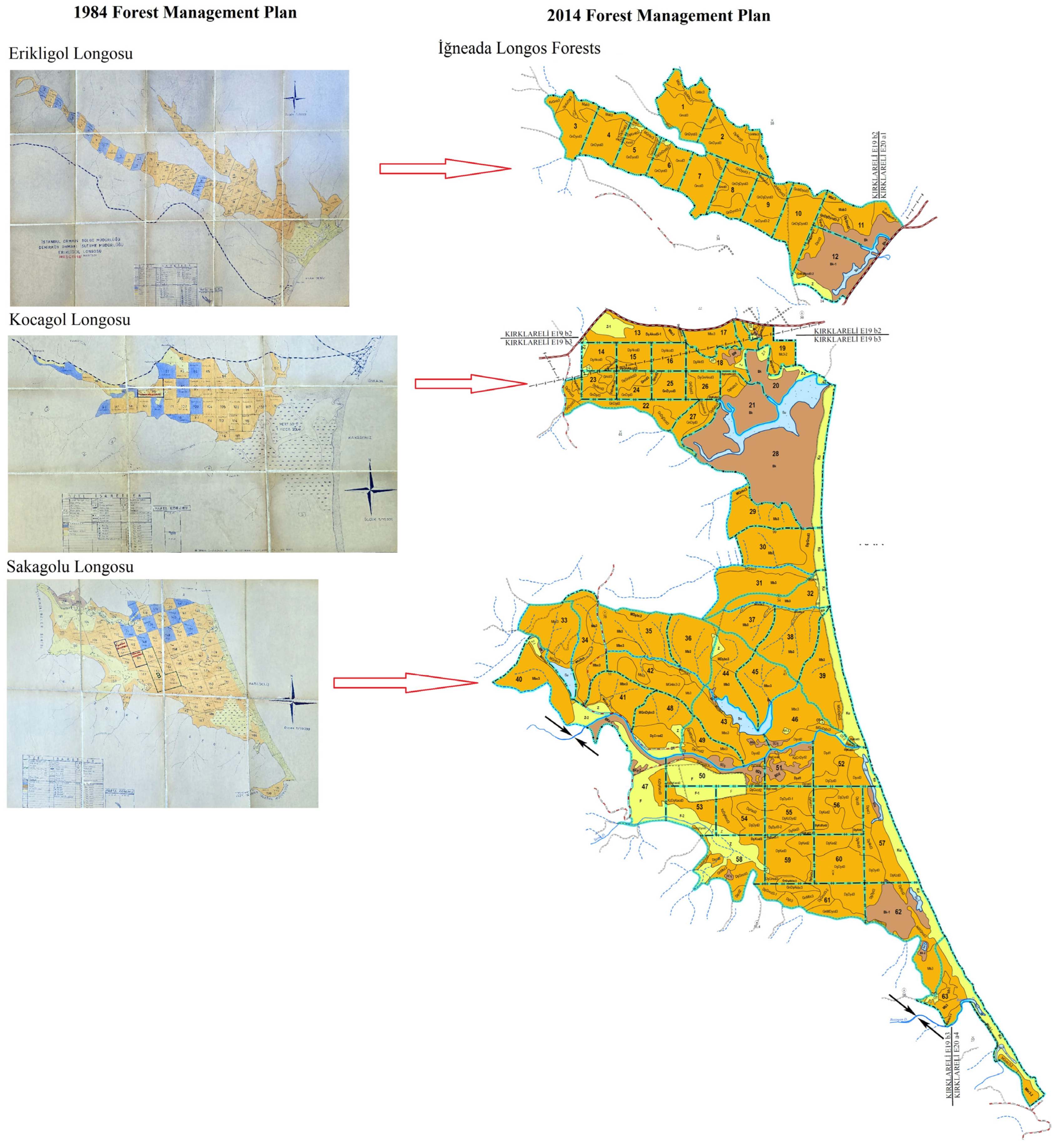
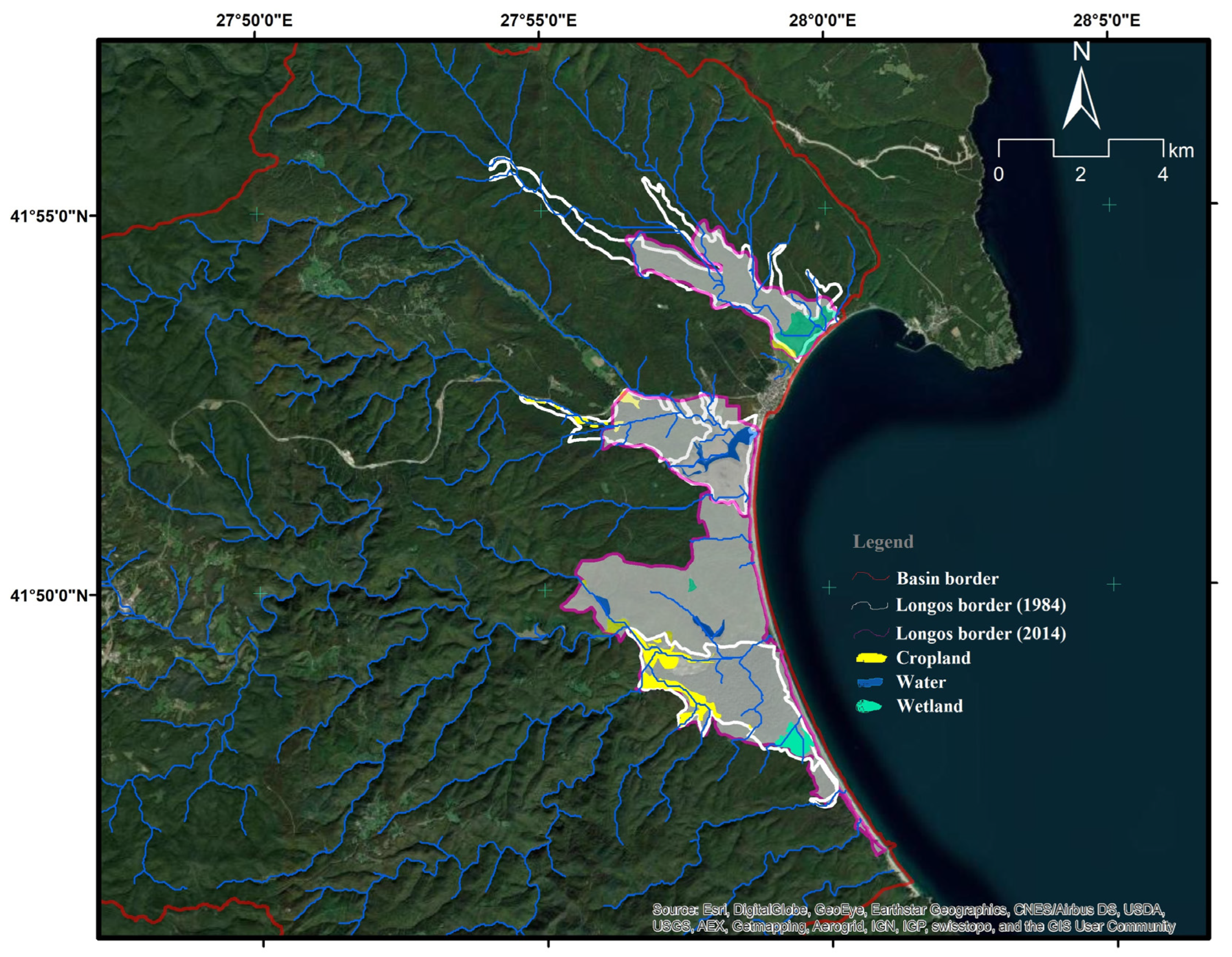
3.1. Forest Management Plan LULC Changes

As with all forests in Turkey, the İğneada Longos Forests within the study area are managed and planned under the authority of the General Directorate of Forestry. The earliest forest management unit delineation for the basin dates back to 1984. Under the 1984 Forest Management Plans (FMPs), the Erikli, Kocagöl, and Sakagöl Longos forests were collectively included within a single planning unit. Following the designation of the area as a national park in 2007, a new forest management plan was prepared in 2014, which redefined the area under the unified title of the İğneada Longos Forests, encompassing all three Longos regions. After this designation, the area between the Kocagöl and Sakagöl Longos forests was also incorporated into the planning unit and managed accordingly. This study examines land use and land cover (LULC) changes in the Longos forests between 1984 and 2014, based on forest management plan records, which are comprehensively documented in references [39] and [41]. Specifically, the 1984 FMP, which contains detailed information on the boundaries and functional classifications of the Longos areas, was obtained in hard copy and subsequently digitized for spatial analysis. The 2014 FMPs were accessed in digital format and used to assess updated land cover classifications and planning boundaries [41]. These two sources serve as the primary references for LULC change detection in the study area. To ensure consistency across both periods, land cover was categorized under four classes: wetland, cropland, water, and wetland forest (Table 2). The change analysis was based on the spatial extent and classifications defined in the 1984 FMP (Figure 3).
Between 1984 and 2014, the total area of the Erikli Longos decreased by 108.91 hectares. Notably, 9.12 hectares of cropland were established within the wetland boundary, posing a threat to the ecosystem. The wetland in the Erikli Longos is primarily sustained by upstream watercourses, and the extent of wetland forest decreases toward the lower parts of the watershed. Despite this, the wetland and water classes in Erikli Longos have remained relatively intact. In the Kocagöl Longos, while wetland and water areas have been preserved, cropland has increased slightly, by 1.82 hectares. For the Sakagöl Longos, however, existing wetland areas have either disappeared or become degraded. Nonetheless, 9.88 hectares of new wetlands have emerged within the Sakagöl boundaries, and cropland has expanded by 29.96 hectares. The newly included longos section between the Kocagöl and Sakagöl areas, encompassing 2475.29 hectares, contains 16.29 hectares of cropland and 23.25 hectares of water. Due to the presence of Pedina and Hamam lakes and the surrounding forests, this area was integrated into the 2014 management plan (Figure 4)
A comparative analysis of the overlapping areas in the 1984 and 2014 plans (Figure 3) reveals that the extent of forest land has remained relatively stable. However, it is important to highlight a decline in the presence of pioneer species such as the lowland maple and European ash, which are moderately tolerant of dry and hot climatic conditions. This decline is attributed to anthropogenic pressures and the increasing severity and duration of droughts. In stands dominated by lowland maple and European ash, no significant reduction in volume has been observed. Conversely, in mixed stands where lowland maple and European ash are subordinate species, evidence suggests a retreat of these species from the area. Considering the site’s designation as a national park and the period between the two management plans, an increase in the volume of European ash and hornbeam (external budding) species might have been expected. However, the data indicates a substantial decline in their volumes within mixed forest stands—from 6.05 m3 to 0.92 m3 for European ash, and from 0.99 m3 to 0.18 m3 for hornbeam. This trend reflects a natural successional process in the study area, leading to the gradual exclusion of these species from the forest structure. A comparative analysis of the overlapping areas in the 1984 and 2014 forest management plans [39,41] is given in Figure 3, and a GIS analysis (conversions, spatial analyssis, and analysis tools) of this change is provided in Figure 4.
In addition to the observable effects of climate change, LULC planning plays a critical role in shaping the ecological dynamics of İğneada Longos Forests, which have been assigned the status of a protected area. Strategic forest management decisions, such as the redefinition of planning units, the inclusion of new areas in the conservation status, and the categorization of functional forest types, directly affect habitat connectivity, water holding capacity, and the resilience of wetland ecosystems. Climate-induced stressors, such as prolonged drought and increasing temperatures, contribute to changes in species composition and forest structure, while anthropogenic changes in land use, such as agricultural encroachment and changes in forest function classifications, can further exacerbate ecological vulnerability. For example, as documented in the Erikli and Sakagöl Longos regions, the conversion of wetlands to agricultural land not only fragments habitats but also reduces the buffering capacity of these ecosystems against hydrological and climatic fluctuations. Therefore, a comprehensive assessment of LULC change, together with climate variables, is essential to understand the cumulative effects on biodiversity, hydrology, and forest health. Integrating these dimensions into forest planning and conservation strategies is vital to maintaining the ecological integrity of floodplain forests under increasing environmental pressures.

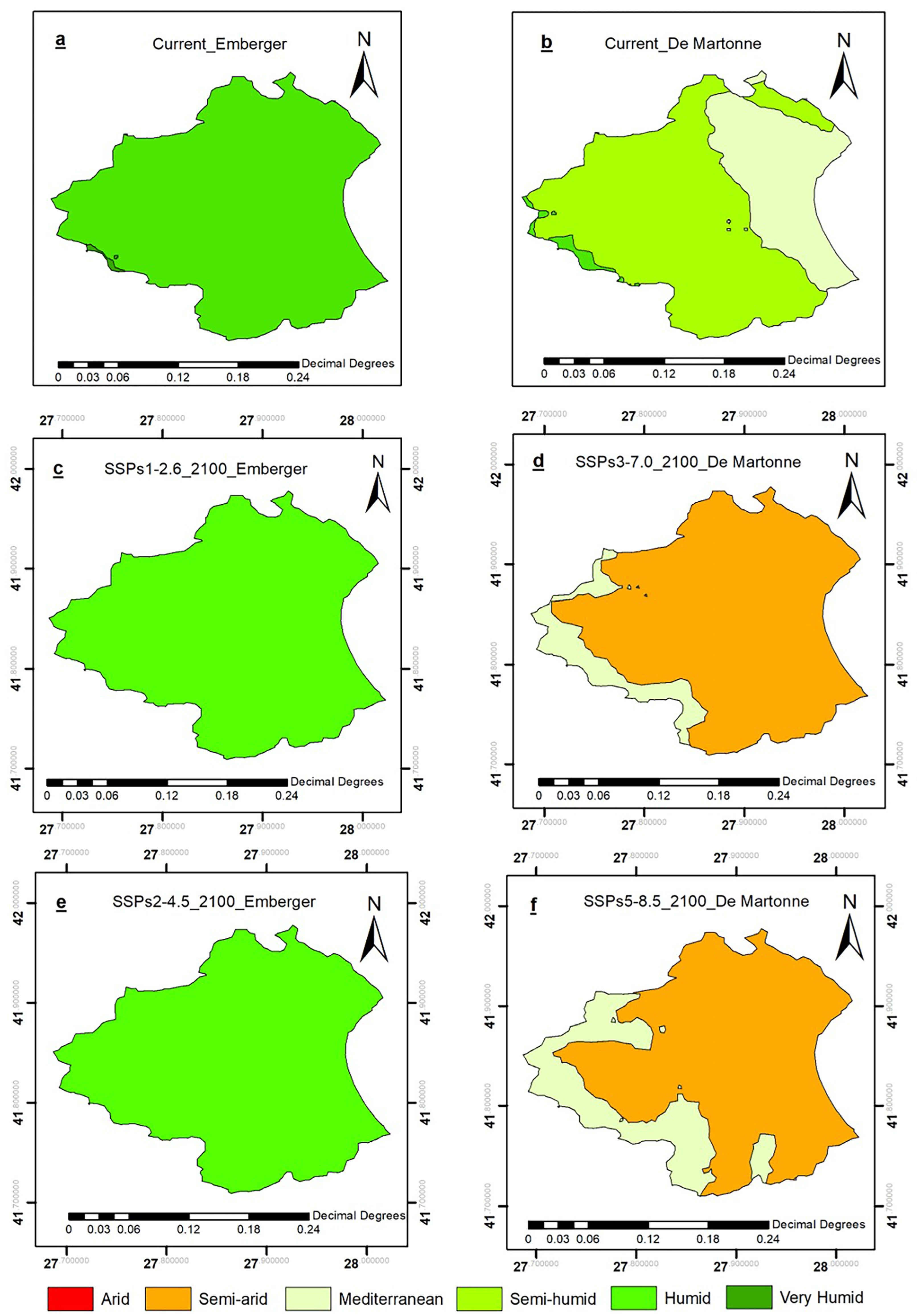
3.2. Assessment of Climatic Shifts Under SSPs

As a result of the modeling carried out within the scope of the study, the validation values of the ROC curve were calculated as 0.985–0.604, 0.985–0.811, 0.852–0.870, and 0.652–0.750 (AUC > 0.5) for each scenario (SSPs1–2.6, SSPs2–4.5, SSPs3–7.0, and SSPs5–8.5), respectively. The findings show that the Emberger index has a higher predictive power for the SSPs1–2.6 and SSPs2–4.5 scenarios, and the De Martonne index has a higher predictive power for the SSPs3–7.0 and SSPs5–8.5 scenarios. This situation suggests that the region was significantly affected by the driest periods in cases where low material growth and energy intensity and global population growth continued in the second half of the century [67]. The increase in monthly mean temperature (~2.75 °C) over a 44-year period is sufficient to predict total precipitation and mean temperature values [51,68] in situations where strong environmental degradation is combined with the exploitation of abundant fossil fuel resources and the adoption of energy-intensive lifestyles worldwide.
When analyzing the current status of the research area according to climate types and to the De Martonne index in Figure 5b, 28.3% of the area is under the influence of the Mediterranean climate, 70.1% is under the influence of the semi-humid climate, and 1.6% is under the influence of the humid climate. When analyzing the spatial distribution of the research area according to climate types using the Emberger index, in Figure 5a, 98.6% of the research area is under the influence of a semi-humid climate zone, and 1.4% is under the influence of a humid climate zone.
The model results obtained within the scope of future projections for the study area according to the SSPs1–2.6 and SSPs2–4.5 scenarios are given in Figure 5c,e. According to both scenarios, it is observed that humid areas will completely disappear towards 2100 (Table 3). According to the SSPs3–7.0 and SSPs5–8.5 scenarios, it was determined that by 2100, the Mediterranean climate type will prevail in 89.25% and 77.58% of the study area, respectively, which has an area of approximately 496.29 km2 and does not currently display a Mediterranean climate type (Figure 5d,f).
The classification of climate in the Igneada Longos Forests and the five basins feeding this ecosystem provides critical insights into the region’s vulnerability to climate change. By comparing climate classification maps based on the De Martonne index (DMI) and the Emberger index (EI), this study has demonstrated that shifts in climatic conditions will significantly impact vegetation patterns and ecosystem dynamics. The findings indicate that climate-induced changes may lead to substantial transformations in landscape characteristics, particularly in response to increased aridity and water stress [51,69]. These projected changes pose considerable risks to sensitive endemic species and aquatic biodiversity, emphasizing the need for proactive adaptation and conservation measures. The observed trend of increasing drought, particularly its northward expansion in recent decades [70,71], aligns with broader global patterns of climate change. Within and beyond protected areas, altered precipitation regimes and rising temperatures are permanently modifying natural vegetation structures. The intensification of water stress due to climate change fosters the proliferation of ruderal plant species, which could further threaten the ecological integrity of coastal ecosystems [72,73]. Such ecological shifts underscore the necessity for targeted management strategies to mitigate adverse effects on biodiversity and ecosystem services. Despite the establishment of protected areas to conserve high-value landscapes, current efforts to combat climate change remain inadequate. A critical challenge is the lack of coordinated stakeholder engagement and community participation in climate adaptation strategies. Furthermore, conservation objectives may be at odds with the development of modern infrastructure, including flood control systems, dams, and reservoirs, which contribute to habitat fragmentation and landscape degradation. These competing interests necessitate an integrated approach that balances conservation with socioeconomic development priorities [74].
Long-term climate projections highlight significant reductions in precipitation across Turkey, particularly under high-emission scenarios such as RCP8.5. Analysis of precipitation and temperature changes using Earth Map (https://earthmap.org) revealed a 20.23 mm increase in precipitation and a 1.83 °C increase in temperature (Figure 2). Studies indicate that by 2100, autumn precipitation may decline by up to 50% nationwide [75], with more severe impacts projected for specific regions such as Düzce, Bolu, and Mersin [76]. Similar studies emphasize that Mediterranean bioclimatic regions will increasingly depend on supplementary irrigation to meet their water demands [51]. These findings highlight the urgent need for evidence-based policy measures to safeguard both natural and protected areas against climate variability. The comparison between the Emberger and De Martonne indices in this study revealed critical insights into climate classification methodologies. While the Emberger index identified more extensive semi-humid zones, the De Martonne index characterized a greater portion of the study area as having a Mediterranean climate. Notably, altitudes above 315 m consistently exhibited semi-humid classifications across all scenarios, indicating some resilience to increasing aridity. However, under the SSP3–7.0 and SSP5–8.5 scenarios, the De Martonne index suggests that the İğneada Longos Forests will transition to a semi-arid climate by 2080. Approximately 88.2% of the study area will be under the influence of a semi-arid climate. Given that arid and semi-arid regions experience greater vulnerability to climate variability [77], these projections raise concerns about the long-term sustainability of regional water resources and ecosystem stability. Furthermore, Turkey’s susceptibility to extreme temperature increases, with estimates reaching up to 6 °C by 2100 [78], underscores the need for urgent climate mitigation efforts. Climate-driven shifts in ecological conditions are expected to influence a wide range of sectors, from biodiversity conservation to energy production, as well as socioeconomic activities [76]. Notably, plant species with limited mobility and short life cycles are particularly vulnerable to these environmental changes [79]. Forests play a significant role in global carbon sequestration by acting as carbon sinks that absorb and store carbon dioxide (CO2) from the atmosphere [80]. In addition to their carbon storage capacity, forests further support climate resilience by increasing soil stability and water retention [81].
Floodplain forests, in particular, as well as coastal forests, play a critical role in carbon sequestration due to their high biomass productivity and capacity to store organic carbon in both vegetation and soil [16,82]. Floodplain forests, characterized by periodic floods within the study area, facilitate carbon accumulation in waterlogged soils, reducing decomposition rates and improving long-term storage [36]. However, these ecosystems face serious threats from climate change, land conversion, and pollution, which may reduce their carbon sequestration capacity [83]. This study suggests that increasing drought and water stress, specifically, will negatively affect carbon sequestration in the future. Increasing drought and intensifying water stress due to climate change will significantly reduce the carbon sequestration tendencies of coastal ecosystems such as floodplain forests. Protecting and restoring these unique forest types is essential to maximizing their role in the global carbon cycle and mitigating climate change. As a result, forestry management and conservation planning must incorporate predictive modeling to identify future species distributions and implement assisted migration strategies, where necessary [84,85]. Developing resilient species and genotypes that can withstand varying environmental stressors is essential for ensuring long-term ecosystem stability [86,87].

4. Conclusions

The comparative analysis of the 1984 and 2014 forest management plans for the İğneada Longos Forests indicates that, although the overall forest area has remained relatively stable, substantial changes have occurred in land use and species composition due to both natural processes and anthropogenic influences. The expansion of cropland within wetland boundaries—particularly in the Erikli and Sakagöl Longos—poses a significant threat to the ecological integrity of these sensitive habitats, despite observed gains in wetland forest areas in Kocagöl and Sakagöl. Furthermore, the decline in pioneer and moderately drought-tolerant species such as the English lowland maple (Quercus robur subsp. Robur L.) and European ash (Fraxinus excelsior L.), particularly in mixed stands, reflects a shift in species composition driven by intensified drought conditions and human activities. These changes suggest ongoing natural succession processes that may lead to long-term alterations in forest structure and function. Consequently, there is an urgent need for adaptive management strategies that incorporate both ecological dynamics and human impacts to safeguard the floodplain forest ecosystems.
In parallel, climate change remains one of the most pressing environmental challenges of our time, exerting direct and indirect effects on all living systems. The accumulation of greenhouse gases—particularly carbon dioxide (CO2), primarily from fossil fuel combustion since the Industrial Revolution—has significantly contributed to global warming. As reported by the IPCC [88], atmospheric CO2 concentrations have increased by 47% compared to pre-industrial levels, reaching 412 ppm in 2023, with cumulative emissions estimated at approximately 2400 ± 240 Gt CO2 from 1850 to 2019. In this context, natural carbon sinks such as floodplain forests, including the İğneada Longos Forests, are critical not only for biodiversity conservation but also for maintaining global climate stability. As the ocean’s carbon absorption capacity declines, the protection and sustainable management of terrestrial ecosystems have become necessities.
This study underscores the importance of climate classification in assessing the vulnerability of the İğneada Longos Forests and its surrounding basins to climate change. By applying the De Martonne and Emberger indices, the analysis reveals that increasing aridity and changing precipitation regimes will likely lead to significant shifts in vegetation structure, with semi-arid conditions predicted to dominate under high-emission scenarios (SSP3–7.0 and SSP5–8.5). Such transitions are expected to have profound implications for biodiversity, especially for endemic and aquatic species reliant on stable hydrological conditions. The projected loss of humid climatic zones by 2100 and the growing influence of Mediterranean climate characteristics underscore the need for urgent and proactive adaptation measures.
Forests, particularly floodplain, coastal, and aquatic types, play a crucial role in carbon sequestration and climate change mitigation. However, intensifying drought and water stress threaten their capacity to function effectively as carbon sinks. Therefore, targeted conservation interventions are essential. This study highlights the need for integrated strategies that incorporate ecosystem-based adaptation, sustainable water resource management, and active stakeholder participation. The findings reinforce the importance of predictive modeling in forestry and conservation planning, aiming to ensure the long-term sustainability of vulnerable ecosystems. Future research should prioritize understanding species resilience, exploring assisted migration options, and developing climate-adaptive forestry practices to mitigate both the ecological and socioeconomic impacts of climate change in the İğneada Region.

Author Contributions

Conceptualization, H.B.Ö., T.V. and A.A.; methodology, H.B.Ö., T.V. and A.A.; software, H.B.Ö. and F.Ş.B.; validation, G.B. and C.G.; formal analysis, F.Ş.B. and İ.B.; investigation, H.B.Ö., T.V., İ.B., F.Ş.B. and C.G.; resources, İ.B.; data curation, T.V. and F.Ş.B.; writing—original draft preparation, İ.B., H.B.Ö., T.V. and A.A.; writing—review and editing, İ.B. and G.B.; visualization, H.B.Ö., T.V., A.A. and F.Ş.B.; supervision, G.B. and C.G.; project administration, A.A., G.B. and C.G.; funding acquisition, A.A., G.B. and C.G. All authors have read and agreed to the published version of the manuscript.

Funding

This research received no external funding.

Data Availability Statement

The data is contained within the article. Apart from this, everything that has been processed and used in the computer programs can be provided by the authors upon request.

Conflicts of Interest

The authors declare no conflicts of interest.

References

  1. Jiang, J.; DeAngelis, D.L.; Teh, S.-Y.; Krauss, K.W.; Wang, H.; Li, H.; Smith, T.J., III; Koh, H.-L. Defining the next Generation Modeling of Coastal Ecotone Dynamics in Response to Global Change. Ecol. Model. 2016, 326, 168–176. [Google Scholar] [CrossRef]
  2. Krauss, K.W.; Noe, G.B.; Duberstein, J.A.; Conner, W.H.; Stagg, C.L.; Cormier, N.; Jones, M.C.; Bernhardt, C.E.; Graeme Lockaby, B.; From, A.S. The Role of the Upper Tidal Estuary in Wetland Blue Carbon Storage and Flux. Glob. Biogeochem. Cycles 2018, 32, 817–839. [Google Scholar] [CrossRef]
  3. Ardón, M.; Potter, K.M.; White, E., Jr.; Woodall, C.W. Coastal Carbon Sentinels: A Decade of Forest Change along the Eastern Shore of the US Signals Complex Climate Change Dynamics. PLoS Clim. 2025, 4, e0000444. [Google Scholar] [CrossRef]
  4. Cormier, N.; Krauss, K.W.; Conner, W.H. Periodicity in Stem Growth and Litterfall in Tidal Freshwater Forested Wetlands: Influence of Salinity and Drought on Nitrogen Recycling. Estuaries Coasts 2013, 36, 533–546. [Google Scholar] [CrossRef]
  5. Haaf, L.; Dymond, S.F. Growth Conditions of Tree Species Relative to Climate Change and Sea Level Rise in Low-Lying Mid Atlantic Coastal Forests. Front. For. Glob. Chang. 2024, 7, 1362650. [Google Scholar] [CrossRef]
  6. Conner, W.H.; Doyle, T.W.; Krauss, K.W.; Doyle, T.W.; O’Neil, C.P.; Melder, M.P.V.; From, A.S.; Palta, M.M. Tidal Freshwater Swamps of the Southeastern United States: Effects of Land Use, Hurricanes, Sea-Level Rise, and Climate Change. In Ecology of Tidal Freshwater Forested Wetlands of the Southeastern United States; Springer: Berlin/Heidelberg, Germany, 2007; pp. 1–28. [Google Scholar]
  7. Antonellini, M.; Mollema, P.N. Impact of Groundwater Salinity on Vegetation Species Richness in the Coastal Pine Forests and Wetlands of Ravenna, Italy. Ecol. Eng. 2010, 36, 1201–1211. [Google Scholar] [CrossRef]
  8. Alongi, D.M. The Impact of Climate Change on Mangrove Forests. Curr. Clim. Chang. Rep. 2015, 1, 30–39. [Google Scholar] [CrossRef]
  9. Schaeffer-Novelli, Y.; Soriano-Sierra, E.J.; Vale, C.C.D.; Bernini, E.; Rovai, A.S.; Pinheiro, M.A.A.; Schmidt, A.J.; de Almeida, R.; Coelho, C.; Menghini, R.P. Climate Changes in Mangrove Forests and Salt Marshes. Braz. J. Ocean. Oceanogr. 2016, 64, 37–52. [Google Scholar] [CrossRef]
  10. Yang, H.; Zhang, X.; Hong, Y. Classification, Production, and Carbon Stock of Harvested Wood Products in China from 1961 to 2012. Bioresources 2014, 9, 4311–4322. [Google Scholar] [CrossRef]
  11. Wasson, K.; Woolfolk, A.; Fresquez, C. Ecotones as Indicators of Changing Environmental Conditions: Rapid Migration of Salt Marsh–Upland Boundaries. Estuaries Coasts 2013, 36, 654–664. [Google Scholar] [CrossRef]
  12. Smith, A.J.; Goetz, E.M. Climate Change Drives Increased Directional Movement of Landscape Ecotones. Landsc. Ecol. 2021, 36, 3105–3116. [Google Scholar] [CrossRef]
  13. Chen, X.; Ye, G.; Zhang, L.; Cai, Y.; Moseman-Valtierra, S.; Li, X.; He, Q. Coastal Ecotones Under Anthropogenic Influences: Conservation, Restoration and Realignment; Frontiers Media SA: Lausanne, Switzerland, 2023; ISBN 2832537138. [Google Scholar]
  14. Spalding, M.D.; Ruffo, S.; Lacambra, C.; Meliane, I.; Hale, L.Z.; Shepard, C.C.; Beck, M.W. The Role of Ecosystems in Coastal Protection: Adapting to Climate Change and Coastal Hazards. Ocean Coast. Manag. 2014, 90, 50–57. [Google Scholar] [CrossRef]
  15. Cooley, S.; Schoeman, D.; Bopp, L.; Boyd, P.; Donner, S.; Kiessling, W.; Martinetto, P.; Ojea, E.; Racault, M.F.; Rost, B. Oceans and Coastal Ecosystems and Their Services; Cambridge University Press: Cambridge, UK, 2023. [Google Scholar]
  16. Islam, I.; Cui, S.; Hoque, M.Z.; Abdullah, H.M.; Tonny, K.F.; Ahmed, M.; Ferdush, J.; Xu, L.; Ding, S. Dynamics of Tree Outside Forest Land Cover Development and Ecosystem Carbon Storage Change in Eastern Coastal Zone, Bangladesh. Land 2022, 11, 76. [Google Scholar] [CrossRef]
  17. Finkl, C.W.; Makowski, C. Coastal Ecosystems of the World. J. Coast Res. 2021, 100, 1–230. [Google Scholar] [CrossRef]
  18. Jobe, J.G.D., IV; Gedan, K. Species-specific Responses of a Marsh-forest Ecotone Plant Community Responding to Climate Change. Ecology 2021, 102, e03296. [Google Scholar] [CrossRef]
  19. Burkett, V.R.; Nicholls, R.J.; Fernandez, L.; Woodroffe, C. Climate Change Impacts on Coastal Biodiversity. In Climate Change and Biodiversity in the Americas, 1st ed.; Fenech, A., MacIver, D., Dallmeier, F., Eds.; Environment Canada: Ottawa, ON, Canada, 2008; pp. 167–193. [Google Scholar]
  20. IPCC. Climate Change 2007: Impacts, Adaptation and Vulnerability, Contribution of Working Group II to the Fourth Assessment Report of the Intergovernmental Panel on Climate Change; IPCC: Geneva, Switzerland, 2007. [Google Scholar]
  21. Parmesan, C.; Yohe, G. A Globally Coherent Fingerprint of Climate Change Impacts across Natural Systems. Nature 2003, 421, 37–42. [Google Scholar] [CrossRef]
  22. IPCC. Climate Change 2023: Synthesis Report. Contribution of Working Groups I, II and III to the Sixth Assessment Report of the Intergovernmental Panel on Climate Change; IPCC: Geneva, Switzerland, 2023; pp. 1–34. [Google Scholar]
  23. IPCC. Climate Change 2014: Synthesis Report. In Contribution of Working Groups I, II and III to the Fifth Assessment Report of the Intergovernmental Panel on Climate Change; IPCC: Geneva, Switzerland, 2014. [Google Scholar]
  24. Nie, Y.; Ji, C.; Yang, H. The Forest Ecological Footprint Distribution of Chinese Log Imports. For. Policy Econ. 2010, 12, 231–235. [Google Scholar] [CrossRef]
  25. Nicholls, R.J.; Wong, P.P.; Burkett, V.; Codignotto, J.O.; Hay, J.; Roger, F.; Ragoonaden, S.; Woodroffe, C.D. Coastal Systems and Low-Lying Areas; Cambridge University Press: Cambridge, UK, 2007. [Google Scholar]
  26. Ogle, K.; Whitham, T.G.; Cobb, N.S. Tree-ring Variation in Pinyon Predicts Likelihood of Death Following Severe Drought. Ecology 2000, 81, 3237–3243. [Google Scholar] [CrossRef]
  27. Niinemets, Ü. Responses of Forest Trees to Single and Multiple Environmental Stresses from Seedlings to Mature Plants: Past Stress History, Stress Interactions, Tolerance and Acclimation. For. Ecol. Manag. 2010, 260, 1623–1639. [Google Scholar] [CrossRef]
  28. Butler-Leopold, P.R.; Iverson, L.R.; Thompson, F.R.; Brandt, L.A.; Handler, S.D.; Janowiak, M.K.; Shannon, P.D.; Swanston, C.W.; Bearer, S.; Bryan, A.M. Mid-Atlantic Forest Ecosystem Vulnerability Assessment and Synthesis: A Report from the Mid-Atlantic Climate Change Response Framework Project; Gen. Tech. Rep. NRS-18; Department of Agriculture, Forest Service, Northern Research Station: Newtown Square, PA, USA, 2018; Volume 181, 294p.
  29. Dupigny-Giroux, L.-A.L.; Mecray, E.L.; Lemcke-Stampone, M.D.; Hodgkins, G.A.; Lentz, E.; Mills, K.E.; Lane, E.D.; Miller, R.; Hollinger, D.Y.; Solecki, W.D. Northeast; US Global Change Research Program: Washington, DC, USA, 2018.
  30. Swanston, C.; Brandt, L.A.; Janowiak, M.K.; Handler, S.D.; Butler-Leopold, P.; Iverson, L.; Thompson, F.R., III; Ontl, T.A.; Shannon, P.D. Vulnerability of Forests of the Midwest and Northeast United States to Climate Change. Clim. Chang. 2018, 146, 103–116. [Google Scholar] [CrossRef]
  31. Sabine, C.L.; Feely, R.A.; Gruber, N.; Key, R.M.; Lee, K.; Bullister, J.L.; Wanninkhof, R.; Wong, C.S.L.; Wallace, D.W.R.; Tilbrook, B. The Oceanic Sink for Anthropogenic CO2. Science 2004, 305, 367–371. [Google Scholar] [CrossRef]
  32. Alongi, D.M. Impacts of Climate Change on Blue Carbon Stocks and Fluxes in Mangrove Forests. Forests 2022, 13, 149. [Google Scholar] [CrossRef]
  33. Tian, L.; Tao, Y.; Fu, W.; Li, T.; Ren, F.; Li, M. Dynamic Simulation of Land Use/Cover Change and Assessment of Forest Ecosystem Carbon Storage under Climate Change Scenarios in Guangdong Province, China. Remote Sens. 2022, 14, 2330. [Google Scholar] [CrossRef]
  34. Ballut-Dajud, G.A.; Sandoval Herazo, L.C.; Fernández-Lambert, G.; Marín-Muñiz, J.L.; López Méndez, M.C.; Betanzo-Torres, E.A. Factors Affecting Wetland Loss: A Review. Land 2022, 11, 434. [Google Scholar] [CrossRef]
  35. Pecl, G.T.; Araújo, M.B.; Bell, J.D.; Blanchard, J.; Bonebrake, T.C.; Chen, I.-C.; Clark, T.D.; Colwell, R.K.; Danielsen, F.; Evengård, B. Biodiversity Redistribution under Climate Change: Impacts on Ecosystems and Human Well-Being. Science 2017, 355, eaai9214. [Google Scholar] [CrossRef]
  36. Vatandaslar, C.; Bolat, F.; Abdikan, S.; Pamukcu-Albers, P.; Satiral, C. Modeling Aboveground Carbon in Flooded Forests Using Synthetic Aperture Radar Data: A Case Study from a Natural Reserve in Turkish Thrace. iForest-Biogeosciences For. 2024, 17, 277. [Google Scholar] [CrossRef]
  37. Holland, M.E. Ecotones: The Role of Landscape Boundaries in Management and Restoration of Changing Environments; Springer Science & Business Media: Berlin/Heidelberg, Germany, 2012; ISBN 1461596866. [Google Scholar]
  38. Bailey, R.G. Ecosystem Geography: From Ecoregions to Sites; Springer Science & Business Media: Berlin/Heidelberg, Germany, 2009; ISBN 0387895159. [Google Scholar]
  39. GEF. Igneada Flora and Vegetation Report, General Directorate of Nature Conservation and National Parks, Biodiversity and Natural Resource Management Project (GEF-II); GEF: Ankara, Turkey, 2005. [Google Scholar]
  40. Özyavuz, M. Planning of the Part of Yıldız Mountains Located Between Iğneada and Demirköy as a Biosphere Reserve; Ankara University: Ankara, Turkey, 2008. [Google Scholar]
  41. Anonymous. Iğneada Conservation Area Management Plan, Biodiversity and Natural Resource Management Project; İğneada Project Implementation Unit: Kırklareli, Turkey, 2003. [Google Scholar]
  42. Morales, C.; Díaz, A.S.-P.; Dionisio, D.; Guarnieri, L.; Marchi, G.; Maniatis, D.; Mollicone, D. Earth Map: A Novel Tool for Fast Performance of Advanced Land Monitoring and Climate Assessment. J. Remote Sens. 2023, 3, 0003. [Google Scholar] [CrossRef]
  43. Rodriguez, E.; Morris, C.S.; Belz, J.E. A Global Assessment of the SRTM Performance. Photogramm. Eng. Remote Sens. 2006, 72, 249–260. [Google Scholar] [CrossRef]
  44. Zanaga, D.; Van De Kerchove, R.; Daems, D.; De Keersmaecker, W.; Brockmann, C.; Kirches, G.; Wevers, J.; Cartus, O.; Santoro, M.; Fritz, S. ESA WorldCover 10 m 2021 V200; International Institute for Applied Systems Analysis: Laxenburg, Austria, 2022. [Google Scholar]
  45. Lavers, D.A.; Simmons, A.; Vamborg, F.; Rodwell, M.J. An Evaluation of ERA5 Precipitation for Climate Monitoring. Q. J. R. Meteorol. Soc. 2022, 148, 3152–3165. [Google Scholar] [CrossRef]
  46. Varol, T.; Canturk, U.; Cetin, M.; Ozel, H.B.; Sevik, H. Impacts of Climate Change Scenarios on European Ash Tree (Fraxinus excelsior L.) in Turkey. For. Ecol. Manag. 2021, 491, 119199. [Google Scholar] [CrossRef]
  47. Phillips, S.J.; Anderson, R.P.; Schapire, R.E. Maximum Entropy Modeling of Species Geographic Distributions. Ecol. Model. 2006, 190, 231–259. [Google Scholar] [CrossRef]
  48. Warren, D.L.; Seifert, S.N. Ecological Niche Modeling in Maxent: The Importance of Model Complexity and the Performance of Model Selection Criteria. Ecol. Appl. 2011, 21, 335–342. [Google Scholar] [CrossRef]
  49. Merow, C.; Smith, M.J.; Silander, J.A., Jr. A Practical Guide to MaxEnt for Modeling Species’ Distributions: What It Does, and Why Inputs and Settings Matter. Ecography 2013, 36, 1058–1069. [Google Scholar] [CrossRef]
  50. Muscarella, R.; Galante, P.J.; Soley-Guardia, M.; Boria, R.A.; Kass, J.M.; Uriarte, M.; Anderson, R.P. ENM Eval: An R Package for Conducting Spatially Independent Evaluations and Estimating Optimal Model Complexity for Maxent Ecological Niche Models. Methods Ecol. Evol. 2014, 5, 1198–1205. [Google Scholar] [CrossRef]
  51. Charalampopoulos, I.; Vlami, V.; Kokkoris, I.P.; Droulia, F.; Doxiadis, T.; Kitsara, G.; Zogaris, S.; Lazoglou, M. A High-Resolution Analysis of the de Martonne and Emberger Indices Under Different Climate Change Scenarios: Implications on the Natural and Agricultural Landscape of Northeastern Greece. Land 2025, 14, 494. [Google Scholar] [CrossRef]
  52. Crapart, C.; Anquetin, S.; Blanchet, J.; Diedhiou, A. Global Projections of Aridity Index for Mid and Long-Term Future Based on CMIP6 Scenarios. EGUsphere 2025, 2025, 1–32. [Google Scholar]
  53. Climate-Data Copernicus Climate Change Service. Available online: https://en.climate-data.org/asia/turkey-67/ (accessed on 29 April 2025).
  54. WorldClim. Global Climate and Weather Data. Available online: https://www.worldclim.org/data (accessed on 29 April 2025).
  55. MGM. Climate and Weather Data. Available online: https://www.mgm.gov.tr (accessed on 29 April 2025).
  56. Dorfman, D.D.; Berbaum, K.S.; Metz, C.E. Receiver Operating Characteristic Rating Analysis: Generalization to the Population of Readers and Patients with the Jackknife Method. Investig. Radiol. 1992, 27, 723–731. [Google Scholar] [CrossRef]
  57. Fawcett, T. An Introduction to ROC Analysis. Pattern Recognit. Lett. 2006, 27, 861–874. [Google Scholar] [CrossRef]
  58. Wiley, E.O.; McNyset, K.M.; Peterson, A.T.; Robins, C.R.; Stewart, A.M. Niche Modeling Perspective on Geographic Range Predictions in the Marine Environment Using a Machine-Learning Algorithm. Oceanography 2003, 16, 102–127. [Google Scholar] [CrossRef]
  59. Anderson, R.P.; Lew, D.; Peterson, A.T. Evaluating Predictive Models of Species’ Distributions: Criteria for Selecting Optimal Models. Ecol. Model. 2003, 162, 211–232. [Google Scholar] [CrossRef]
  60. Peterson, A.T.; Papeş, M.; Soberón, J. Rethinking Receiver Operating Characteristic Analysis Applications in Eco-logical Niche Modeling. Ecol. Model. 2008, 213, 63–72. [Google Scholar] [CrossRef]
  61. Howell, K.L.; Holt, R.; Endrino, I.P.; Stewart, H. When the Species Is Also a Habitat: Comparing the Predictively Modelled Distributions of Lophelia Pertusa and the Reef Habitat It Forms. Biol. Conserv. 2011, 144, 2656–2665. [Google Scholar] [CrossRef]
  62. Radosavljevic, A.; Anderson, R.P. Making Better Maxent Models of Species Distributions: Complexity, Overfitting and Evaluation. J. Biogeogr. 2014, 41, 629–643. [Google Scholar] [CrossRef]
  63. Buckman-Sewald, J.; Whorton, C.R.; Root, K. V Developing Macrohabitat Models for Bats in Parks Using Maxent and Testing Them with Data Collected by Citizen Scientists. Int. J. Biodivers. Conserv. 2014, 6, 171–183. [Google Scholar]
  64. Li, J.; Fan, G.; He, Y. Predicting the Current and Future Distribution of Three Coptis Herbs in China under Climate Change Conditions, Using the MaxEnt Model and Chemical Analysis. Sci. Total Environ. 2020, 698, 134141. [Google Scholar] [CrossRef]
  65. Yan, H.; Feng, L.; Zhao, Y.; Feng, L.; Wu, D.; Zhu, C. Prediction of the Spatial Distribution of Alternanthera Philoxeroides in China Based on ArcGIS and MaxEnt. Glob. Ecol. Conserv. 2020, 21, e00856. [Google Scholar] [CrossRef]
  66. IPCC. IPCC agrees outlines of Sixth Assessment Report (AR6). In Proceedings of the 46th Session of the Panel, Montreal, QC, Canada, 5–10 September 2017. [Google Scholar]
  67. Özhatay, N.; Akalın, E.; Güler, N.; Ersoy, H.; Yeşil, Y.; Demirci, S. Floristic Richness and Conservation Priority Sites in the Northwest of European Turkey: Mt Yıldız-Kırklareli. Phytol. Balc. 2013, 19, 77–88. [Google Scholar]
  68. Tabari, H.; Talaee, P.H.; Nadoushani, S.S.M.; Willems, P.; Marchetto, A. A Survey of Temperature and Precipitation Based Aridity Indices in Iran. Quat. Int. 2014, 345, 158–166. [Google Scholar] [CrossRef]
  69. Chalmoukis, I.A. Assessing Coastal Vulnerability to Storms: A Case Study on the Coast of Thrace, Greece. J. Mar. Sci. Eng. 2023, 11, 1490. [Google Scholar] [CrossRef]
  70. Alessandri, A.; De Felice, M.; Zeng, N.; Mariotti, A.; Pan, Y.; Cherchi, A.; Lee, J.-Y.; Wang, B.; Ha, K.-J.; Ruti, P. Robust Assessment of the Expansion and Retreat of Mediterranean Climate in the 21 St Century. Sci. Rep. 2014, 4, 7211. [Google Scholar] [CrossRef]
  71. Carvalho, D.; Pereira, S.C.; Silva, R.; Rocha, A. Aridity and Desertification in the Mediterranean under EURO-CORDEX Future Climate Change Scenarios. Clim. Chang. 2022, 174, 28. [Google Scholar] [CrossRef]
  72. Schmitz, M.F.; Herrero-Jáuregui, C. Cultural Landscape Preservation and Social–Ecological Sustainability. Sustainability 2021, 13, 2593. [Google Scholar] [CrossRef]
  73. Tsiakiris, R.; Stara, K.; Kazoglou, Y.; Kakouros, P.; Bousbouras, D.; Dimalexis, A.; Dimopoulos, P.; Fotiadis, G.; Gianniris, I.; Kokkoris, I.P. Agroforestry and the Climate Crisis: Prioritizing Biodiversity Restoration for Resilient and Productive Mediterranean Landscapes. Forests 2024, 15, 1648. [Google Scholar] [CrossRef]
  74. Sheng, J.; Yang, H. Collaborative Models and Uncertain Water Quality in Payments for Watershed Services: China’s Jiuzhou River Eco-Compensation. Ecosyst. Serv. 2024, 70, 101671. [Google Scholar] [CrossRef]
  75. Demircan, M.; Demir, Ö.; Atay, H.; Eskioğlu, O.; Tüvan, A.; Akçakaya, A. Climate Change Projections for Turkey with New Scenarios. In Proceedings of the Climate Change and Climate Dynamics Conference-2014–CCCD2014, Istanbul, Turkey, 8–10 October 2014; pp. 8–10. [Google Scholar]
  76. Arıcak, B.; Cantürk, U.; Koç, İ.; Erdem, R.; Şevik, H. Shifts That May Appear in Climate Classifications in Bursa Due to Global Climate Change. Forestist 2024, 74, 129–137. [Google Scholar] [CrossRef]
  77. Zhang, Q.; Xu, C.-Y.; Tao, H.; Jiang, T.; Chen, Y.D. Climate Changes and Their Impacts on Water Resources in the Arid Regions: A Case Study of the Tarim River Basin, China. Stoch. Environ. Res. Risk Assess. 2010, 24, 349–358. [Google Scholar] [CrossRef]
  78. Turan, E.S. Turkey’s Drought Status Associated with Climate Change. J. Nat. Hazards Environ. 2018, 4, 63–69. [Google Scholar]
  79. Varol, T.; Cetin, M.; Ozel, H.B.; Sevik, H.; Zeren Cetin, I. The Effects of Climate Change Scenarios on Carpinus Betulus and Carpinus Orientalis in Europe. Water Air Soil Pollut. 2022, 233, 45. [Google Scholar] [CrossRef]
  80. Malhi, Y.; Meir, P.; Brown, S. Forests, Carbon and Global Climate. Philosophical Transactions of the Royal Society of London. Ser. A Math. Phys. Eng. Sci. 2002, 360, 1567–1591. [Google Scholar] [CrossRef]
  81. Psistaki, K.; Tsantopoulos, G.; Paschalidou, A.K. An Overview of the Role of Forests in Climate Change Mitigation. Sustainability 2024, 16, 6089. [Google Scholar] [CrossRef]
  82. Zhang, Y.; Zhao, M.; Cui, Q.; Fan, W.; Qi, J.; Chen, Y.; Zhang, Y.; Gao, K.; Fan, J.; Wang, G. Processes of Coastal Ecosystem Carbon Sequestration and Approaches for Increasing Carbon Sink. Sci. China Earth Sci. 2017, 60, 809–820. [Google Scholar] [CrossRef]
  83. Kılıç, N.K.; Dağdeviren, R.Y.; Aykır, D.; Fural, Ş.; Kükrer, S.; Doğan, T.; Mutlu, Y.E.; Yakupoğlu, N. Vegetation History of Karacabey Longoz Forest and Surrounding Area During the Last 250 Years (Bursa, Türkiye). J. Geogr. 2024, 49, 31–41. [Google Scholar]
  84. Ning, H.; Ling, L.; Sun, X.; Kang, X.; Chen, H. Predicting the Future Redistribution of Chinese White Pine Pinus Armandii Franch. Under Climate Change Scenarios in China Using Species Distribution Models. Glob. Ecol. Conserv. 2021, 25, e01420. [Google Scholar] [CrossRef]
  85. Varol, T.; Canturk, U.; Cetin, M.; Ozel, H.B.; Sevik, H.; Zeren, C. Identifying the Suitable Habitats for Anatolian Boxwood (Buxus sempervirens L.) for the Future Regarding the Climate Change. Theor. Appl. Clim. Climatol. 2022, 150, 637–647. [Google Scholar] [CrossRef]
  86. Ozel, H.B.; Cetin, M.; Sevik, H.; Varol, T.; Isik, B.; Yaman, B. The Effects of Base Station as an Electromagnetic Radiation Source on Flower and Cone Yield and Germination Percentage in Pinus Brutia Ten. Biol. Futur. 2021, 72, 359–365. [Google Scholar] [CrossRef]
  87. Ozel, H.B.; Abo Aisha, A.E.S.; Cetin, M.; Sevik, H.; Zeren Cetin, I. The Effects of Increased Exposure Time to UV-B Radiation on Germination and Seedling Development of Anatolian Black Pine Seeds. Environ. Monit. Assess. 2021, 193, 388. [Google Scholar] [CrossRef]
  88. IPCC. Climate Change 2021: The Physical Science Basis. In Contribution of Working Group I to the Sixth Assessment Report of the Intergovernmental Panel on Climate Change; IPCC: Geneva, Switzerland, 2021. [Google Scholar]
Figure 1. Climate change factors affecting coastal regions [25].
Forests 16 00976 g001
Figure 2. Study area and its climate characteristics: (a) elevation; (b) slope; (c) LULC map; (d) long-term trends of precipation and temperature.
Forests 16 00976 g002
Figure 3. LULC-based forest management plans.
Forests 16 00976 g003
Figure 4. GIS analysis of LULC changes.
Forests 16 00976 g004
Figure 5. Potential distribution of climate types. (a). Current situation according to Emberger; (b). Current situation according to De Martonne, (c). According to Emberger, the SSPs1–2.6 scenario for the year 2100, (d). According to De Martonne, the SSPs3–7.0 scenario for the year 2100. (e) According to Emberger, the SSPs2–4.5 scenario for the year 2100. (f). According to De Martonne, the SSPs5–8.5 scenario for the year 2100.
Forests 16 00976 g005
Table 1. Phytoclimatic classification according to DMI and EI [51].
DMIEI (Q)
AridDMI < 10Hyper-arid E I (Q) < 10
Semi-arid10   D M I < 2 0Arid 10 E I ( Q ) < 30
Mediterranean 20     D M I < 2 4
Semi-humid 24 D M I < 28Semi-arid 30 E I ( Q ) < 65
Humid 28 D M I < 35Sub-humid 65 E I ( Q ) < 120
Very humid 35 D M I 55 Humid 120 E I ( Q ) 170
Extremely humid D M I > 55 Hyper-humid E I   ( Q ) > 170
Table 2. Land use change in İgneada Longos Forests.
LULC ClassesErikli LongosKocagol LongosSakagol Longos
FMP_1984 (ha)FMP_2014 (ha)FMP_1984 (ha)FMP_2014 (ha)FMP_1984 (ha)FMP_2014 (ha)
Wetland Forest520.44462.45288.75286.93551.6551.6
Wetland86.5386.53226.80226.8040.07-
Water7.097.0941.5441.54-9.88
Cropland 9.1226.7528.57110.49140.45
Total (ha)674.06565.15583.84583.84702.16702.16
Table 3. Areal and proportional changes, according to model.
Climate TypesSSPs1–2.6SSPs2–4.5
20402060208021002040206020802100
Semi-arid--------
Semi-humid494.73 (99.7%)496.29 (100%)496.29 (100%)496.29 (100%)493.70 (99.48)496.26 (99.99%)496.29 (100%)496.29 (100%)
Humid1.56 (0.3%)---2.60 (0.52%)0.04 (0.01%)--
Climate TypesSSPs3–7.0SSPs5–8.5
20402060208021002040206020802100
Semi-arid--104.53 (21.06%)442.97 (89.25%)--11.19
(2.26%)
385.02 (77.58%)
Mediterranean152.99 (30.83%)321.63 (64.80%)391.06 (78.80%)53.33
(10.75%)
183.67 (37.00%)457.44
(92.17%)
474.77
(95.66%)
111.27 (22.42%)
Semi-humid337.27 (67.96%)174.67 (35.20%)0.71
(0.14%)
-309.24 (62.31%)38.86
(7.83%)
10.32
(2.08%)
-
Humid6.03 (1.21%)---3.39 (0.69%)---
Disclaimer/Publisher’s Note: The statements, opinions and data contained in all publications are solely those of the individual author(s) and contributor(s) and not of MDPI and/or the editor(s). MDPI and/or the editor(s) disclaim responsibility for any injury to people or property resulting from any ideas, methods, instructions or products referred to in the content.

