
Heterogeneity and Influencing Factors of Carbon Sequestration Efficiency of Green Space Patterns in Urban Riverfront Residential Blocks

 ,
,
Abstract
1. Introduction
2. Data and Methods
2.1. Study Area
2.2. Data Acquisition
2.2.1. Basic Data of Land Use
2.2.2. Remote Sensing Data
2.2.3. Meteorological Data
2.2.4. Vegetation Type Data
2.3. Estimation of the CS Capacity of the Residential Block
2.4. Index System Affecting CS Capacity in Residential Blocks
2.4.1. Selection of the Spatial Pattern Indices of the Green Space
2.4.2. Tree Species Composition Indices of the Green Space
2.4.3. Selection of Block Spatial Environment Indices
2.5. Effects of the Influencing Factors on the CS of the Green Space in Riverfront Residential Blocks
2.5.1. Multiple Spatial Factors on the NPP Pattern by the RF Algorithm
2.5.2. Morphological Combination Characteristics and CS Capacity Analysis of Green Patches
3. Results
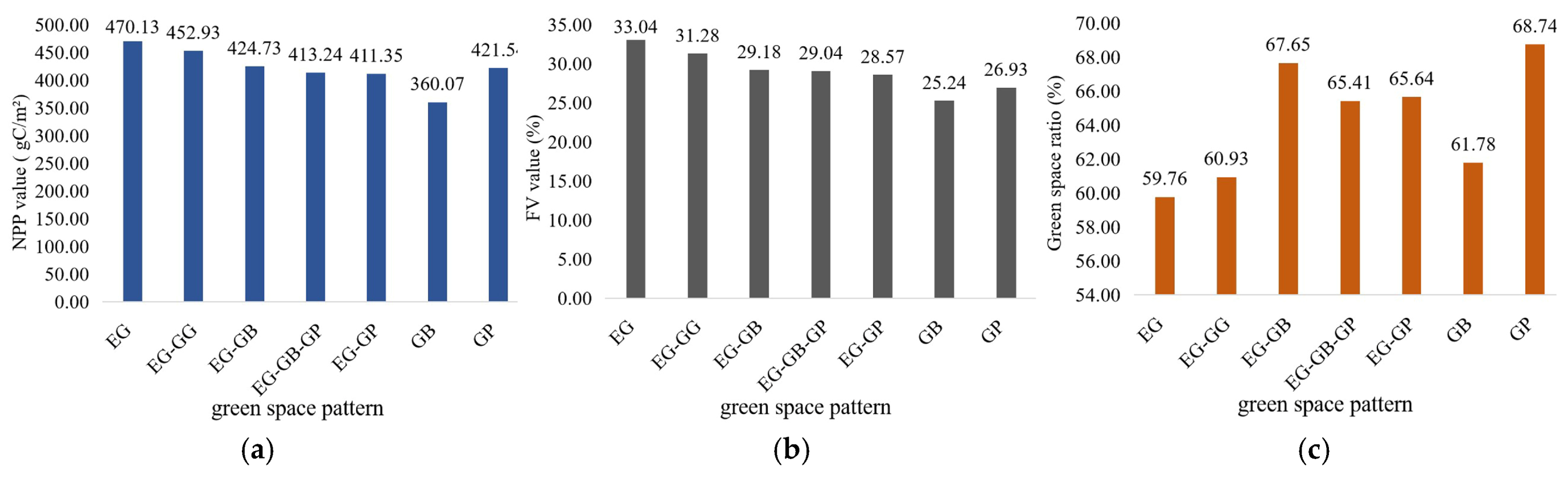
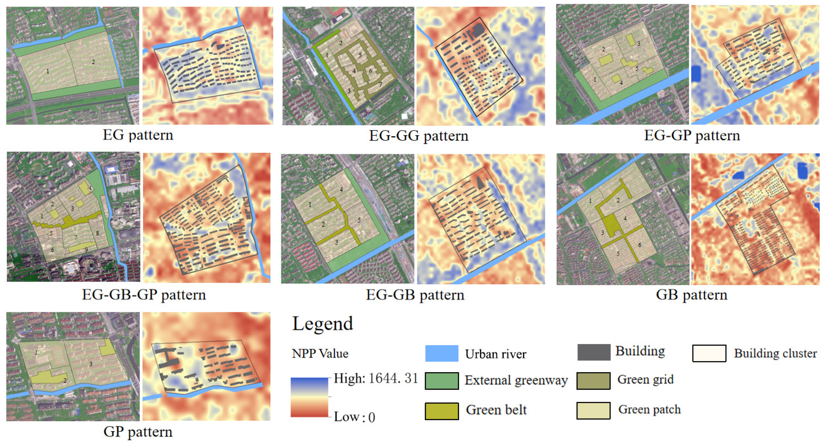
3.1. NPP Distribution Characteristics of Different Green Space Layout Patterns in Residential Blocks
3.1.1. NPP Variations of Different Green Space Pattern Types
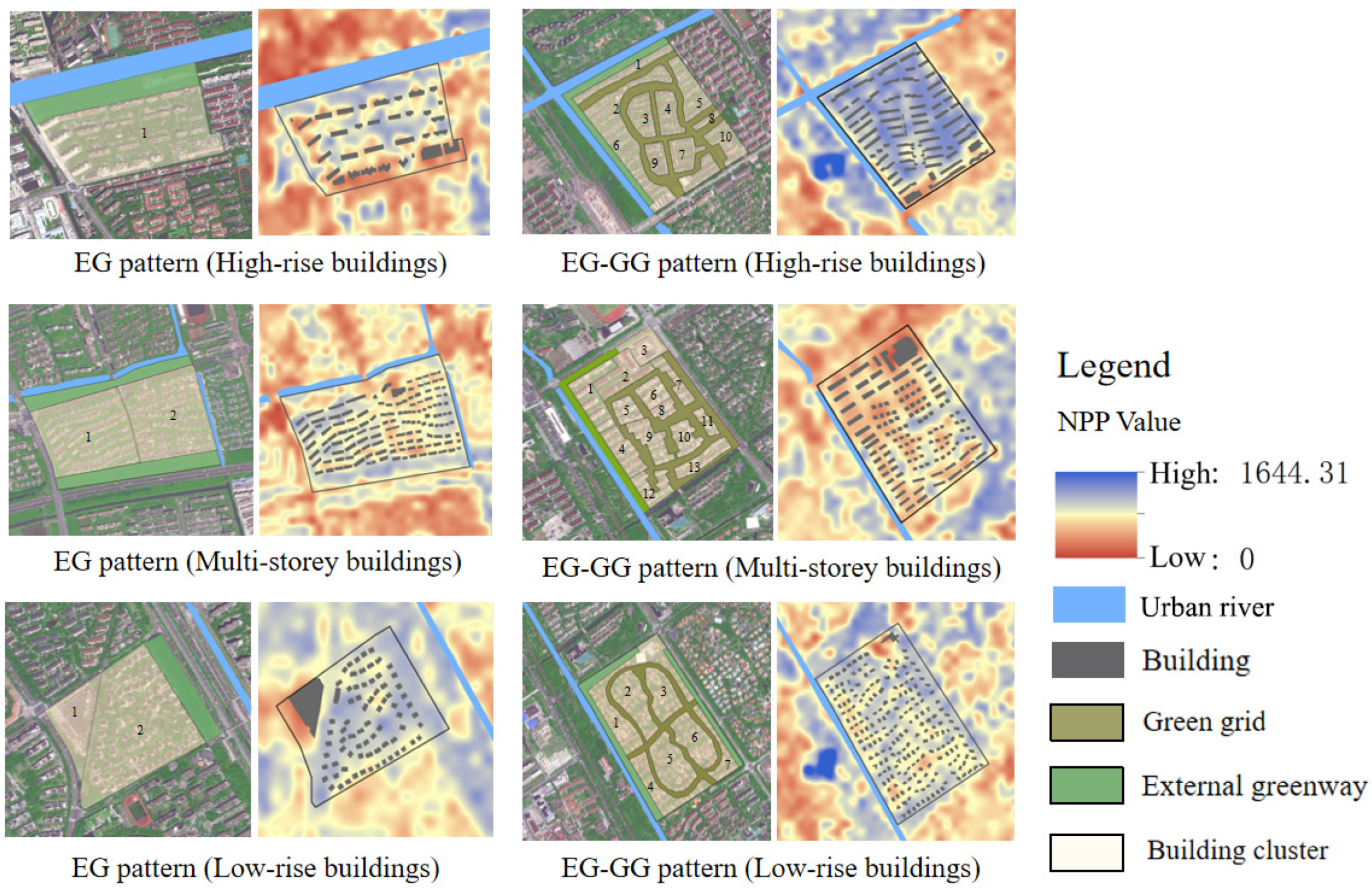
3.1.2. NPP Heterogeneity Distribution in Different Green Space Patterns
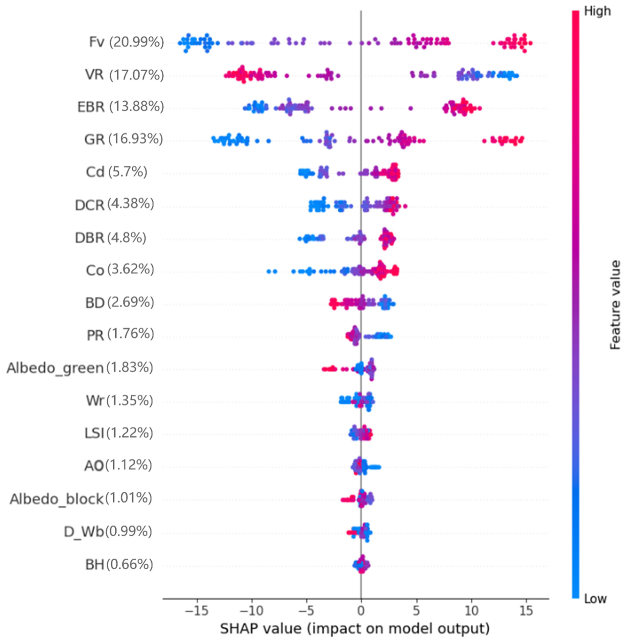
3.2. The Significance of the Contribution of Block Space Form Factors to NPP
3.3. Effects of the Single Influencing Factor on the CS in Riverfront Residential Blocks
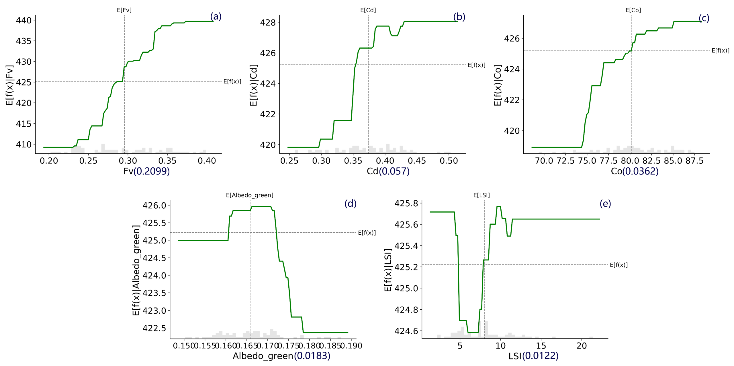
3.3.1. CS Influence from Spatial Pattern Factors of Green Space
3.3.2. CS Influence from Tree Species Composition of the Green Space
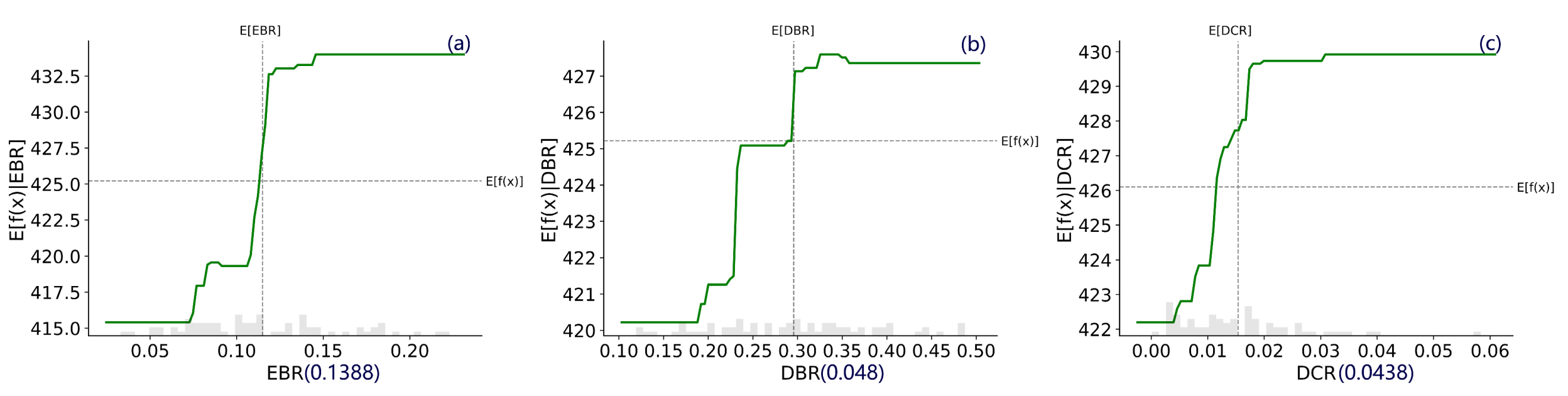
3.3.3. CS Influence from Spatial Environmental Factors of the Green Space
3.4. Effects of the Morphological Combination Characteristics Factors on the CS in Riverfront Residential Blocks
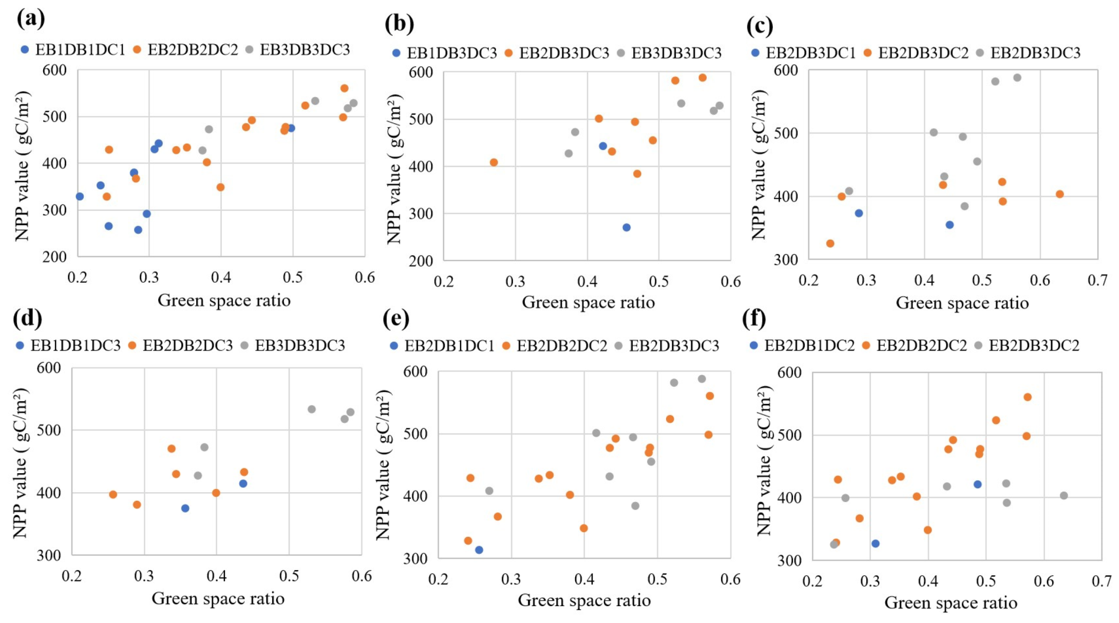
3.4.1. The Influence from the Spatial Pattern Combination Factors of Green Space
3.4.2. The Influence from the Greenery Tree Species Types Combination Factors
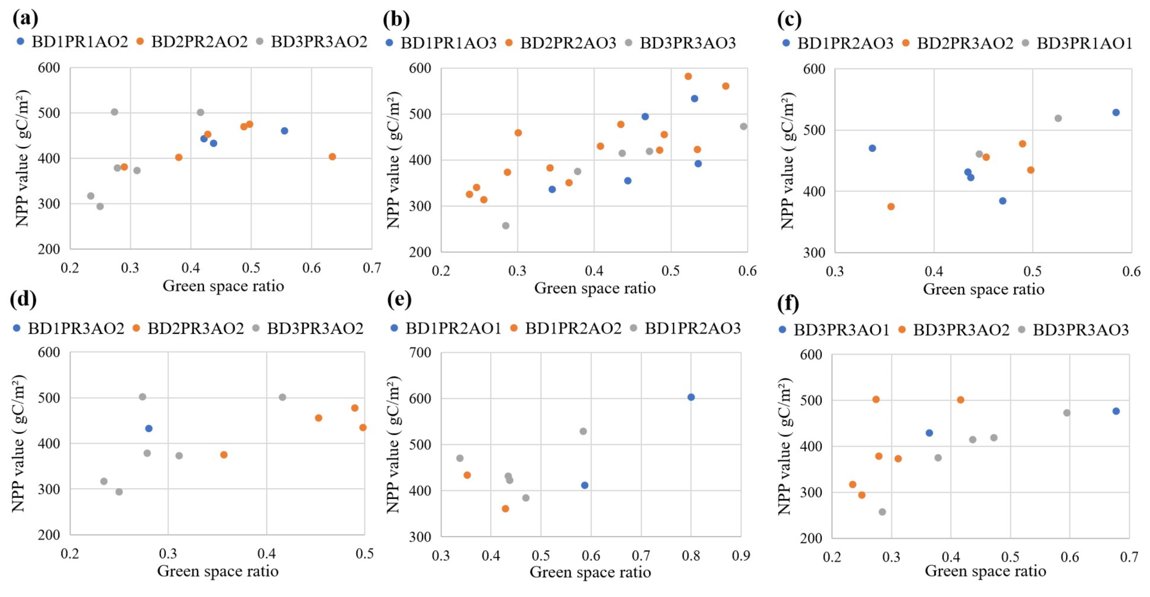
3.4.3. The Influence from the Spatial Environmental Combination Factors
4. Discussion
4.1. Green Space Pattern and CS Potential of Riverfront Residential Blocks
4.2. Vegetation Structure and CS Potential of Riverfront Residential Blocks
4.3. Insights from CS Improvement of Green Spaces in Different Residential Blocks
4.4. Limitation
5. Conclusions
Author Contributions
Funding
Data Availability Statement
Conflicts of Interest
References
- Hobbie, S.E.; Grimm, N.B. Nature-based approaches to managing climate change impacts in cities. Philos. Trans. R. Soc. B Biol. Sci. 2020, 375, 20190124. [Google Scholar] [CrossRef] [PubMed]
- Hoegh-Guldberg, O.; Jacob, D.; Taylor, M.; Guill’en Bolãnos, T.; Bindi, M.; Brown, S.; Camilloni, I.A.; Diedhiou, A.; Djalante, R.; Ebi, K.; et al. The human imperative of stabilizing global climate change at 1.5 °C. Science 2019, 365, eaaw6974. [Google Scholar] [CrossRef] [PubMed]
- Liu, Z.; Wang, L.; Wang, P. Analysis on influencing factors of farmers’ intention to manage forestry carbon sinks—An empirical study based on boosted regression tree. South China For. Sci. 2018, 46, 22–28. [Google Scholar] [CrossRef]
- Russo, A.; Escobedo, F.J.; Timilsina, N.; Schmitt, A.O.; Varela, S.; Zerbe, S. Assessing urban tree carbon storage and sequestration in Bolzano, Italy. Int. J. Biodivers. Sci. Ecosyst. Serv. Manag. 2014, 10, 54–70. [Google Scholar] [CrossRef]
- Singkran, N. Carbon sink capacity of public parks and carbon sequestration efficiency improvements in a dense urban landscape. Environ. Monit. Assess. 2022, 194, 750. [Google Scholar] [CrossRef]
- Nowak, D.J.; Greenfield, E.J.; Hoehn, R.E.; Lapoint, E. Carbon storage and sequestration by trees in urban and community areas of the United States. Environ. Pollut. 2013, 178, 229–236. [Google Scholar] [CrossRef]
- Qiu, Z.; Feng, Z.; Song, Y.; Li, M.; Zhang, P. Carbon sequestration potential of forest vegetation in china from 2003 to 2050: Predicting forest vegetation growth based on climate and the environment. J. Clean. Prod. 2022, 252, 119715. [Google Scholar] [CrossRef]
- Shi, T.; Li, P.; Tang, Y. Urban carbon sink function and promotion strategy under the background of carbon neutrality—A case study of Shengyang core area. Chin. Landsc. Archit. 2022, 38, 78–83. [Google Scholar] [CrossRef]
- Zhu, N.; Li, M.; Chai, Y. Ecological functions of green land system in Harbin. Chin. J. Appl. Ecol. 2002, 13, 1117–1120. [Google Scholar] [CrossRef]
- Li, X.; Jiang, Y.; Liu, Y.; Sun, Y.; Li, C. The impact of landscape spatial morphology on green carbon sink in the urban riverfront area. Cities 2024, 148, 104919. [Google Scholar] [CrossRef]
- Brinck, K.; Fischer, R.; Groeneveld, J.; Lehmann, S.; Mateus, D.D.P.; Pütz, S.; Sexton, J.O.; Song, D.; Huth, A. High resolution analysis of tropical forest fragmentation and its impact on the global carbon cycle. Nat. Commun. 2017, 8, 14855. [Google Scholar] [CrossRef] [PubMed]
- Guo, H.; Yu, Q.; Pei, Y.; Wang, G.; Yue, D. Optimization of landscape spatial structure aiming at achieving carbon neutrality in desert and mining areas. J. Clean. Prod. 2021, 322, 129156. [Google Scholar] [CrossRef]
- Wang, Z.; Zhu, D.; Wang, X.; Zhang, Y.; Peng, S. Regressions underestimate the direct effect of soil moisture on land carbon sink variability. Group Not. 2022, 28, 7161–7163. [Google Scholar] [CrossRef] [PubMed]
- Godwin, C.; Chen, G.; Singh, K.K. The impact of urban residential development patterns on forest carbon density: An integration of lidar, aerial photography and field mensuration. Landsc. Urban Plan. 2015, 136, 97–109. [Google Scholar] [CrossRef]
- Lin, J.; Ma, Q.; Ju, Y.; Zhang, H.; Wang, Q.; Huang, B. Relationships between urbanization, tree morphology, and carbon density: An integration of remote sensing, allometric models, and field survey. Urban. For. Urban. Green. 2022, 76, 127725. [Google Scholar] [CrossRef]
- Sun, Y.; Xie, S.; Zhao, S. Valuing urban green spaces in mitigating climate change: A city-wide estimate of aboveground carbon stored in urban green spaces of china’s capital. Glob. Change Biol. 2019, 25, 1717–1732. [Google Scholar] [CrossRef]
- Li, C.; Sun, G.; Cohen, E.; Zhang, Y.; Xiao, J.; McNulty Steven, G.; Meentemeyer, R.K. Modeling the impacts of urbanization on watershed-scale gross primary productivity and tradeoffs with water yield across the conterminous United States. J. Hydrol. 2020, 583, 124581. [Google Scholar] [CrossRef]
- Wang, Y.; Chang, Q.; Li, X. Promoting sustainable carbon sequestration of plants in urban greenspace by planting design: A case study in parks of beijing. Urban For. Urban Green. 2021, 64, 127291. [Google Scholar] [CrossRef]
- Jiang, Y.; Liu, Y.; Sun, Y.; Li, X. Distribution of CO2 concentration and its spatial influencing indices in Urban Park green space. Forests 2023, 14, 1396. [Google Scholar] [CrossRef]
- Jiang, Y.; Sun, Y.; Liu, Y.; Li, X. Exploring the correlation between waterbodies, green space morphology, and carbon dioxide concentration distributions in an urban riverfront green space: A simulation study based on the carbon cycle. Sustain. Cities Soc. 2023, 98, 104831. [Google Scholar] [CrossRef]
- Tran, T.J.; Helmus, M.R.; Behm, J.E. Green infrastructure space and traits (gist) model: Integrating green infrastructure spatial placement and plant traits to maximize multifunctionality. Urban. For. Urban. Green. 2020, 49, 126635. [Google Scholar] [CrossRef]
- Raciti, S.M.; Hutyra, L.R.; Newell, J.D. Mapping carbon storage in urban trees with multi-source remote sensing data: Relationships between biomass, land use, and demographics in Boston neighborhoods. Sci. Total Environ. 2015, 538, 1039–1041. [Google Scholar] [CrossRef]
- Stewart, I.D.; Oke, T.R. Local climate zones for urban temperature studies. Bull. Am. Meteorol. Soc. 2012, 93, 1879–1900. [Google Scholar] [CrossRef]
- Hou, H.; Zhang, S.; Ding, Z.; Wang, Y.; Yang, Y.; Guo, S. Temporal variation of near-surface co2 concentrations over different land uses in suzhou city. Environ. Earth Sci. 2016, 75, 1197. [Google Scholar] [CrossRef]
- Feng, Y.; Feng, H. TM data retrieval and analysis of Beijing area surface albedo. Sci. Surv. Map. 2012, 37, 164–167. [Google Scholar] [CrossRef]
- McPherson, E.G.; Xiao, Q.; Aguaron, E. A new approach to quantify and map carbon stored, sequestered and emissions avoided by urban forests. Landsc. Urban Plan. 2013, 120, 70–84. [Google Scholar] [CrossRef]
- Pham, T.-T.-H.; Apparicio, P.; Landry, S.; Lewnard, J. Disentangling the effects of urban form and socio-demographic context on street tree cover: A multi-level analysis from Montreal. Landsc. Urban Plan. 2017, 157, 422–433. [Google Scholar] [CrossRef]
- Wang, Z.C. Thinking on low-carbon community planning from the perspective of carbon emission quantification. Anhui Arch. 2018, 24, 43–46+78. [Google Scholar] [CrossRef]
- Van Vliet, J. Direct and indirect loss of natural area from urban expansion. Nat. Sustain. 2019, 2, 755–763. [Google Scholar] [CrossRef]
- Chen, H.; Yan, W.; Li, Z.; Wende, W.; Xiao, S.; Wan, S.; Li, S. Spatial patterns of associations among ecosystem services across different spatial scales in metropolitan areas: A case study of Shanghai, China. Ecol. Indic. 2022, 136, 108682. [Google Scholar] [CrossRef]
- Proietti, C.; Anav, A.; Vitale, M.; Fares, S.; Marco, A.D. A new wetness index to evaluate the soil water availability influence on gross primary production of European forests. Climate 2019, 7, 42. [Google Scholar] [CrossRef]
- Li, J.; Wang, Z.; Lai, C.; Wu, X.; Zeng, Z.; Chen, X.; Lian, Y. Response of net primary production to land use and land cover change in mainland china since the late 1980s. Sci. Total Environ. 2018, 639, 237–247. [Google Scholar] [CrossRef] [PubMed]
- Lin, J.; Qiu, S.; Tan, X.; Zhuang, Y. Measuring the relationship between morphological spatial pattern of green space and urban heat island using machine learning methods. Build. Environ. 2023, 228, 109910. [Google Scholar] [CrossRef]
- Liu, J.; Wang, Z.; Duan, Y.; Li, X.; Zhang, M.; Liu, H.; Xue, P.; Gong, H.; Wang, X.; Chen, Y.; et al. Effects of land use patterns on the interannual variations of carbon sinks of terrestrial ecosystems in China. Ecol. Indic. 2023, 146, 109914. [Google Scholar] [CrossRef]
- Wu, X.C. Study on Optimal Water Surface Rate of Cities and Towns in Lixiahe Depression Based on Carbon Emission Reduction Requirements. Master’s Thesis, Yangzhou University, Yangzhou, China, 2023. [Google Scholar]
- Haines-Young, R.; Potschin-Young, M.; Czúcz, B. Report on the Use of CICES to Identify and Characterise the Biophysical, Social and Monetary Dimensions of ES Assessments; ESMERALDA: Brussels, Belgium, 2018. [Google Scholar] [CrossRef]
- The Ministry of Natural Resources. GB/T 21010-2017; Classification of Current Land Use. China Standards Press: Beijing, China, 2017; pp. 2–6. Available online: https://m.mnr.gov.cn/dt/ywbb/201810/t20181030_2241239.html (accessed on 4 March 2025).
- Ministry of Housing and Urban-Rural Development of the People’s Republic of China. CJJ/T 85-2017; Classification Standard of Urban Green Space. China Architecture & Building Press: Beijing, China, 2017; pp. 2–8ISBN 1511231380. Available online: https://www.mohurd.gov.cn/gongkai/zc/wjk/art/2018/art_17339_236545.html (accessed on 4 March 2025).
- Breiman, L. Bagging predictors. Mach. Learn. 1996, 24, 123–140. [Google Scholar] [CrossRef]
- Breiman, L. Random forests. Mach. Learn. 2001, 45, 5–32. [Google Scholar] [CrossRef]
- Lundberg, S.M.; Nair, B.; Vavilala, M.S.; Horibe, M.; Eisses, M.J.; Adams, T.; Liston, D.E.; King-Wai Low, D.; Newman, S.; Kim, J.; et al. Explainable machine-learning predictions for the prevention of hypoxaemia during surgery. Nat. Biomed. Eng. 2018, 2, 749–760. [Google Scholar] [CrossRef]
- Fan, Y.; Wei, F. Contributions of natural carbon sink capacity and carbon neutrality in the context of net-zero carbon cities: A case study of hangzhou. Sustainability 2022, 14, 2680. [Google Scholar] [CrossRef]
- Li, X.; Jia, B.; Li, F.; Ma, J.; Liu, X.; Feng, F.; Liu, H. Effects of multi-scale structure of blue–green space on urban forest carbon density: Beijing, China case study. Sci. Total Environ. 2023, 883, 163682. [Google Scholar] [CrossRef]
- Chen, Y.Z.; Feng, X.M.; Tian, H.Q.; Wu, X.T.; Gao, Z.; Feng, Y.; Piao, S.L.; Lv, N.; Pan, N.Q.; Fu, B.J. Accelerated increase in vegetation carbon sequestration in China after 2010: A turning point resulting from climate and human interaction. Glob. Change Biol. 2021, 27, 5848–5864. [Google Scholar] [CrossRef]
- Gou, W.Y.; Zhao, J.Y.; Ma, X. Research on the Optimization Design of Residential Green Spaces in Xi’an Based on the Synergistic Impact of Carbon and Pollution. J. Xi’an Univ. Arch. Technol. 2022, 54, 450–458. [Google Scholar] [CrossRef]
- Dong, H.; Chen, Y.; Huang, X.; Cheng, S. Multi-scenario simulation of spatial structure and carbon sequestration evaluation in residential green space. Ecol. Indic. 2023, 154, 110902. [Google Scholar] [CrossRef]
- Chen, L.; Wang, Y.; Zhu, E.; Wu, H.; Feng, D. Carbon storage estimation and strategy optimization under low carbon objectives for urban attached green spaces. Sci. Total Environ. 2024, 923, 171507. [Google Scholar] [CrossRef]
- Jo, H.-K.; Kim, J.-Y.; Park, H.-M. Carbon reduction and planning strategies for urban parks in Seoul. Urban. For. Urban. Green. 2019, 41, 48–54. [Google Scholar] [CrossRef]
- Gratani, L.; Varone, L.; Bonito, A. Carbon sequestration of four urban parks in Rome. Urban. For. Urban. Green. 2016, 19, 184–193. [Google Scholar] [CrossRef]
- Liu, H.; Zhang, J.; Wang, Z. Assessing and optimizing the potential for climate change mitigation and carbon sequestration in urban residential green spaces: Energizing sustainable cities. Front. Environ. Sci. 2025, 13, 1519297. [Google Scholar] [CrossRef]


| Variables | Description | Calculation Method |
|---|---|---|
| Fractional vegetation coverage (Fv) | The ratio of the vertical projection area of vegetation canopy to the total area of a specific region, usually expressed as a percentage | Derived by inversing Landsat8 multi-band files to obtain Normalized Difference Vegetation Index (NDVI) data in ENVI 5.3 software. Fv are calculated based on the NDVI value. |
| Landscape shape index (LSI) | An index describing the shape complexity of green space patches (or ecological patches). It measures whether the shape of a patch is regular; the more complex the shape, the higher the index value. | Calculated using the Fragstats 4.2 tool. |
| Surface albedo of green space (Albedo) | The ratio of solar radiation reflected by the green space surface to the total incoming solar radiation, expressed as a value between 0 and 1. This metric characterizes the reflective capacity of the green space surface. | Atmospheric correction (FLAASH) and radiometric calibration (calibration type: Reflectance) are applied to Landsat8 multi-band files. Surface albedo is then inversed in ENVI 5.3 software. |
| Canopy density (Cd) | The ratio of the total projected area (crown width) of tree canopies under direct sunlight to the total green space area. This reflects the degree of canopy closure and serves as an index of the connectivity of the tree canopy layer. | Calculated using the vertical canopy density method. First, the crown area of individual trees is estimated using the crown radius formula in ArcGIS. The values are then aggregated to estimate the canopy density for each planting space. |
| Cohesion (Co) | An index for evaluating the spatial distribution (concentration or dispersion) of a specific landscape type, used to measure the natural connectivity of green spaces. A higher value indicates stronger spatial aggregation of the landscape type. | Calculated using the Fragstats 4.2 software platform. |
| Variables | Description | Calculation Method |
|---|---|---|
| Plot ratio (PR) | Refers to the ratio of the total floor area of a residential area to the block land area | |
| Building density (BD) | The ratio of the sum of the base area of the building to the block land area | |
| Building height (BH) | The average height of buildings in the community | |
| Green space ratio (GR) | The ratio between the sum of different types of green areas and the residential land area of the community | |
| Distance from the water body (D_Wb) | The shortest distance between the centre of each neighbourhood and the riverbank | Using the geometry in the property table in ArcGIS, calculate the distance from the block patch to the water surface, calculate the centroid of each block patch and then use the ‘Near’ tool. |
| Vacant land ratio (VR) | The proportion of the architecture’s external space with little or no vegetation cover | |
| Albedo of the block surface (Alb_block) | The ability of the street surface to reflect solar radiation | .373.0018, where B2, B4, B5, B6 and B7 represent the blue band, red band, near-infrared band, short-wave infrared 1 and short-wave infrared 2 bands of Landsat 8 data, respectively. |
| Architectural otherness (AO) | The buildings in the block vary from height to height | , where H is the average BH and is the height of the individual building |
| Waterbody area ratio (Wr) | The ratio of the area of adjacent water to the area of the block |
| Spatial Index Factor | Rank Interval | Factor Rank Code | Spatial Index Factor | Rank Division | Factor Rank Code |
|---|---|---|---|---|---|
| Fv | The boundary values are 0.25 and 0.35 | Fv1, Fv2, Fv3 | EBR | The cutoff values are 8.5% and 15% | EB1, EB2, EB3 |
| Cd | The boundary values are 0.30 and 0.40 | Cd1, Cd2, Cd3 | DBR | The cutoff values are 25% and 35% | DB1, DB2, DB3 |
| Co | The boundary values are 78 and 85 | Co1, Co2, Co3 | DCR | The cutoff values are 1% and 2% | DC1, DC2, DC3 |
| BD | The boundary values are 15% and 20% | BD1, BD2, BD3 | Wr | The cutoff values are 10% and 20% | Wr1, Wr2, Wr3 |
| PR | The boundary values are 0.8 and 1.5 | PR1, PR2, PR3 | D-Wb | The cutoff values are 500 and 1100 | D-Wb1, D-Wb2, D-Wb3 |
| AO | The boundary values are 0.25 and 0.5 | AO1, AO2, AO3 |
Disclaimer/Publisher’s Note: The statements, opinions and data contained in all publications are solely those of the individual author(s) and contributor(s) and not of MDPI and/or the editor(s). MDPI and/or the editor(s) disclaim responsibility for any injury to people or property resulting from any ideas, methods, instructions or products referred to in the content. |
© 2025 by the authors. Licensee MDPI, Basel, Switzerland. This article is an open access article distributed under the terms and conditions of the Creative Commons Attribution (CC BY) license (https://creativecommons.org/licenses/by/4.0/).
Share and Cite
Jiang, Y.; Xu, D.; Peng, L.; Li, X.; Song, T.; Zhan, F. Heterogeneity and Influencing Factors of Carbon Sequestration Efficiency of Green Space Patterns in Urban Riverfront Residential Blocks. Forests 2025, 16, 681. https://doi.org/10.3390/f16040681
Jiang Y, Xu D, Peng L, Li X, Song T, Zhan F. Heterogeneity and Influencing Factors of Carbon Sequestration Efficiency of Green Space Patterns in Urban Riverfront Residential Blocks. Forests. 2025; 16(4):681. https://doi.org/10.3390/f16040681
Chicago/Turabian StyleJiang, Yunfang, Di Xu, Lixian Peng, Xianghua Li, Tao Song, and Fangzhi Zhan. 2025. "Heterogeneity and Influencing Factors of Carbon Sequestration Efficiency of Green Space Patterns in Urban Riverfront Residential Blocks" Forests 16, no. 4: 681. https://doi.org/10.3390/f16040681
APA StyleJiang, Y., Xu, D., Peng, L., Li, X., Song, T., & Zhan, F. (2025). Heterogeneity and Influencing Factors of Carbon Sequestration Efficiency of Green Space Patterns in Urban Riverfront Residential Blocks. Forests, 16(4), 681. https://doi.org/10.3390/f16040681