Abstract
Forests play a key role in carbon sequestration and oxygen production. They significantly contribute to carbon peaking and carbon neutrality goals. Accurate estimation of forest carbon stocks is essential for a precise understanding of the carbon sequestration capacity of forest ecosystems. Remote sensing technology, with its wide observational coverage, strong timeliness, and low cost, is essential for carbon stock estimation research. However, challenges in data acquisition and processing include data variability, signal saturation in dense forests, and environmental limitations. These factors hinder accurate carbon stock estimation. This review summarizes the current state of research on forest carbon stock estimation from two aspects, namely remote sensing data and estimation methods, highlighting both the advantages and the limitations of various data sources and models. It also explores technological innovations and cutting-edge research in the field, focusing on deep learning techniques, optical vegetation thickness estimation methods, and the impact of forest–climate interactions on carbon stock estimation. Finally, the review discusses the current challenges in the field, including issues related to remote sensing data quality, model adaptability, forest stand complexity, and uncertainties in the estimation process. Based on these challenges, the paper looks ahead to future trends, proposing potential technological breakthroughs and pathways. The aim of this study is to provide theoretical support and methodological guidance for researchers in related fields.
1. Introduction
Since the Industrial Age, the increased use of fossil fuels has led to a significant rise in greenhouse gas emissions, particularly carbon dioxide (CO2), a key driver of global warming [1]. This disruption to the ecological balance poses a threat to human living conditions. In 2024, global CO2 emissions are projected to reach 41.6 billion tons, exceeding the 40.6 billion tons recorded in 2023, according to the “Global Carbon Project” in their Global Carbon Budget report [2]. Achieving the Paris Agreement’s target of limiting the global temperature rise to well below 1.5 °C and implementing China’s dual carbon strategy, which aims to peak carbon emissions by 2030 and achieve carbon neutrality by 2060, remain major challenges. Addressing global climate change requires not only reducing carbon emissions but also enhancing carbon sinks. Strengthening the resilience and stability of ecosystems is crucial to increasing their carbon sequestration capacity [3].
Forests, as the largest and most biologically diverse terrestrial ecosystems, have a unique capacity for carbon sequestration and oxygen production [4]. Through photosynthesis, trees absorb atmospheric CO2 and store it in forest biomass, making them one of the most effective and economically viable methods to reduce atmospheric CO2 levels [5]. However, forest carbon sequestration is influenced by forest dynamics and human activities. Forest carbon stocks and the carbon cycle are critical to understanding the role of terrestrial ecosystems in global carbon cycling and climate change [6]. Monitoring carbon stocks and their temporal changes is essential for reducing uncertainties in broader ecosystem carbon cycle models.
Traditional forest inventory methods, which measure tree height, diameter at breast height (DBH), and crown width within sample plots, provide accurate data on forest characteristics. These inventories have been used to develop and validate carbon stock estimation models [7]. For instance, Fang Jingyun et al. [8] utilized fifty years of China’s continuous forest inventory data to assess changes in the country’s forest carbon stocks from 1949 to 1998. Similarly, Andreas Margerl et al. [9] employed the United States’ national, historical, and recent forest inventory data spanning from 1907 to 2012 to evaluate the dynamic variations in carbon content within the native forest ecosystems of the United States during this period. Despite their high accuracy, these traditional methods are time-consuming, labor-intensive, and require tree felling, which can damage ecosystems. Thus, these methods are not scalable or cost-effective for meeting growing demands for forest data.
With the widespread adoption of satellite remote sensing technology and the commercialization of geospatial data in the 1980s, this field has rapidly advanced [10]. However, beyond satellites, other platforms, like aircraft and unmanned aerial vehicles (UAVs), have also emerged as powerful tools in forest monitoring. Aircraft-based observational platforms provide higher spatial resolution and more flexible observation schedules compared to satellites, making them particularly useful for monitoring forest dynamics on a regional scale. UAVs, with their ability to fly at low altitudes, enable highly detailed measurements of forest structure and biomass, offering a cost-effective solution for local-scale monitoring and dynamic changes in forest carbon stocks. These platforms complement satellite data by filling gaps in spatial and temporal resolution, providing more accurate and timely estimates of carbon stocks [11]. Compared to traditional ground-based inventories, which are labor-intensive, time-consuming, and require tree felling, remote sensing platforms provide a more efficient and less invasive method for assessing forest structure and carbon content. Figure 1 illustrates this comparison, highlighting the strengths and limitations of both traditional and remote sensing methods in mapping forest carbon storage distribution.
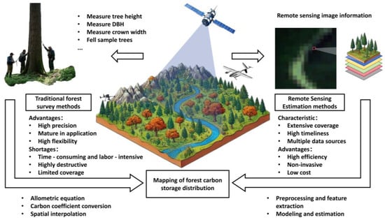
Figure 1.
Comparison of traditional forest survey methods and remote sensing estimation methods for forest carbon storage mapping.
To comprehensively evaluate the estimation methodologies of carbon stocks utilizing observational technology, an extensive literature search was conducted on 10 December 2024 within the Web of Science Core Collection database. The search employed the keywords “forest carbon stocks” and “remote sensing”. A total of 2191 publications, encompassing scientific research articles and other relevant online media literature published between 1999 and 2024, were systematically reviewed and analyzed. The findings were subsequently synthesized, highlighting the annual publication trends, the geographical distribution of research outputs, and the distribution across various academic journals, as illustrated in Figure 2.
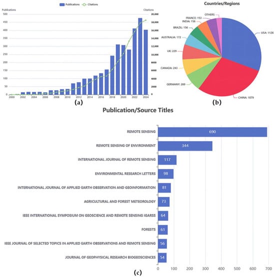
Figure 2.
Trends, geographic distribution of the authors or research institutions, and source titles of publications on forest carbon stock estimation using remote sensing. (a) Annual number of publications and citations from 2000 to 2024, showing a significant increase in both over time. (b) Distribition of publications by country/region, highlighting major contributing countries such as the USA and China. (c) Top publication sources, listing the most frequently appearing journals in this research field, with “Remote Sensing” leading the count.
Figure 2a illustrates a significant increase in both the number of studies and article citations concerning the estimation of forest carbon stocks using remote sensing technology from 2000 to 2024. Notably, since 2022, the annual publication count has exceeded 400 papers for three consecutive years, and the cumulative citation count has surpassed 15,000. This trend reflects the heightened global research activities related to forest above-ground biomass (AGB), driven by the emergence of environmental protection initiatives, such as the Paris Agreement and China’s commitments to carbon peak and carbon neutrality. Figure 2b depicts the distribution of publications based on the country of the first author’s institutional affiliation. The United States, China, and Germany are the leading contributors, with 1126, 1079, and 269 papers, respectively. Figure 2c presents the top 10 journals ranked by publication volume in this domain, highlighting highly esteemed journals in the field of remote sensing, including Remote Sensing (690 papers) and Remote Sensing of Environment (344 papers). These journals are recognized as primary platforms for disseminating research on forest carbon stock estimation and related remote sensing applications. These trends clearly demonstrate the critical role of remote sensing technology in advancing forest carbon monitoring.
With the advent of the era of big geospatial data and the advancement of sensor technologies, the volume of remote sensing data applicable to the estimation of forest carbon stocks is increasing exponentially [12]. Concurrently, developments in computer science have introduced novel methodologies for constructing estimation models [13,14]. Remote sensing data serve as the foundational observational information, while estimation techniques are employed to analyze and infer carbon stocks based on this data.
This paper aims to fill gaps in the current literature by providing a comprehensive review of remote sensing-based forest carbon storage estimation, focusing on technological advances and the limitations inherent in current methodologies. Furthermore, the paper will discuss how current methods can be better applied in real-world contexts, such as climate policy formulation and forest management practices, where precise carbon stock data are crucial for informed decision-making. By presenting an in-depth overview of these areas, this study seeks to supplement existing knowledge and provide insights into future research directions. The ultimate goal is to offer a more nuanced understanding of the challenges in remote sensing-based carbon stock estimation and to propose potential solutions that could advance both theoretical and practical applications of this field.
2. Remote Sensing Data Sources
Remote sensing data can be categorized into optical, synthetic aperture radar (SAR), and light detection and ranging (LiDAR) data based on the sensor type used [15]. These datasets, with varying spatial resolutions and spectral bands, support the estimation of forest carbon stocks.
2.1. Optical Data
Optical remote sensing data are crucial for estimating forest carbon stocks due to variations in reflectance spectral curves across plant species in the visible and near-infrared (NIR) bands. Even within a single species, reflectance can fluctuate based on environmental conditions and phenological stages [16]. These spectral characteristics enable continuous monitoring of plant growth and accurate carbon stock estimation, establishing optical data as a widely used modality in forest carbon stock research. Common reflectance indices, such as the normalized difference vegetation index (NDVI), are used to assess vegetation health and biomass [17], while the enhanced vegetation index (EVI) improves upon the NDVI by reducing atmospheric and soil noise. The photochemical reflectance index (PRI) offers insights into plant photosynthetic activity, further enhancing carbon stock estimation accuracy. Optical data are primarily categorized into multispectral and hyperspectral data.
2.1.1. Multispectral Data
The use of optical remote sensing for carbon stock estimation began in the 1970s, initially with single-band imagery. However, the accuracy of early methods was impacted by atmospheric conditions, soil characteristics, and sensor performance. The use of multispectral data, combining multiple spectral bands, improved accuracy by better correlating with forest biomass and carbon stocks [18]. Today, multispectral datasets, such as Landsat, WorldView, and the GF series, are widely used in forest carbon stock estimation. These datasets are commonly processed using regression techniques that model relationships between carbon stocks and spectral, terrain, and texture variables.
Advancements in sensor technology have led to higher spatial resolution imagery, which aids in classification tasks, such as tree species identification, improving carbon stock estimations [19]. However, high-resolution imagery often lacks comprehensive spectral information, and its higher cost and susceptibility to weather conditions present challenges in practical applications [20].
2.1.2. Hyperspectral Data
Hyperspectral data capture biophysical and chemical characteristics more precisely than multispectral data, making them valuable for carbon stock estimation. Hyperspectral technology originated from the imaging spectrometer research program in the United States. It was first proposed by researchers at the Jet Propulsion Laboratory of the California Institute of Technology and has since made significant advancements with the support of NASA [21]. Compared to multispectral data, hyperspectral data offer the capability to capture biophysical and chemical characteristics across various temporal and spatial scales, utilizing finer spectral resolution bands and providing more comprehensive spectral information [22]. Additionally, the utilization of narrow-band vegetation indices derived from hyperspectral data can mitigate the effects of atmospheric and water absorption, as well as address the saturation issues associated with broadband vegetation indices [23].
However, the large number of spectral bands in hyperspectral data can lead to redundancy, increasing processing and storage costs. Additionally, hyperspectral sensors are more susceptible to atmospheric conditions, requiring rigorous correction techniques to ensure accurate data [22]. Despite these challenges, hyperspectral data provide significant potential for enhancing carbon stock estimates.
2.1.3. Progress in Forest Carbon Stock Estimation Based on Optical Data
Optical data were first applied to the estimation of biomass and carbon stocks, extracting vegetation parameters from images, generating values indicative of biomass through band calculations, and using this information to estimate aboveground biomass of forests (Table 1). This approach is widely used because of its simplicity and high estimation accuracy.

Table 1.
Recent studies on forest carbon stock estimation using optical data.
However, there are still certain limitations in the application of optical data in the study of forest carbon stock estimation. Firstly, optical images may experience a decline in image quality and data loss due to differences in sunlight and cloud interference. Secondly, optical data mainly acquire spectral information within the ground area covered by the image, only providing information on the horizontal distribution of the forest, but do not offer vertical distribution information. Finally, in areas with high forest canopy density and accumulation, optical data may exhibit oversaturation, resulting in a lower estimation of carbon stocks.
2.2. SAR Data
SAR data offer advantages over optical data, including a broader wavelength range, enhanced penetration, and reduced susceptibility to weather conditions, making them valuable for forest carbon stock estimation [28]. SAR data allow for the acquisition of vertical structural information about forests, which is critical for accurate carbon stock calculations [29].
2.2.1. Classification of SAR Data
SAR data can be classified based on polarization modes, frequency bands, and scattering mechanisms [30], with each offering distinct benefits for carbon stock estimation.
- Polarization mode: Single polarization provides basic forest coverage and structural classification. Dual polarization improves vegetation type differentiation and biomass estimation, while full polarization enables precise biomass and carbon stock estimation, particularly in complex forests. Cross-polarization increases sensitivity to volume scattering, beneficial for dense forest structures [31].
- Frequency bands: The P-band and L-band are best for estimating biomass and tree trunk data due to their strong penetration capabilities [32]. The C-band and X-band are used for monitoring forest canopy structures [33], while the Ku-band and Ka-band, which are more suited for monitoring forest health, are less effective for direct carbon stock estimation [34].
- Scattering mechanisms: Volume scattering is key for evaluating forest density and biomass, while double scattering helps estimate trunk density in densely vegetated areas. The backscattering coefficient, influenced by forest structure, aids in inferring biomass and forest health [35].
By utilizing these different classifications, SAR data provide a comprehensive approach to estimating forest carbon stocks, offering detailed insights into forest structure and biomass.
2.2.2. Estimation of Forest Carbon Stocks Using Multi-Frequency SAR Data Synergy
Recent advancements in SAR technology allow for multi-frequency data integration, enhancing the accuracy of forest carbon stock estimations. Polarimetric interferometric SAR, when combined with interferometric phase data, helps delineate the three-dimensional structure of forests, particularly the vertical distribution of tree heights [36]. These 3D structural data are essential for precise biomass and carbon stock estimation [37].
The use of multi-frequency SAR data also addresses the limitations of optical data, which struggles under rainy or cloudy conditions, enhancing the reliability of forest carbon estimates. Additionally, the robustness of SAR data against atmospheric disturbances allows for continuous, reliable monitoring of forest ecosystems, improving long-term forest management and climate mitigation efforts.
2.2.3. Progress in Forest Carbon Stock Estimation Based on SAR Data
SAR data can provide high-quality surface cover information under various weather conditions and is unaffected by cloud cover and precipitation, making it particularly suitable for estimating forest carbon stocks. Through multi-temporal analysis of SAR data, it is possible to effectively monitor changes in forest structure, improving the accuracy and timeliness of carbon stock estimation. Table 2 summarizes recent studies on forest carbon stock estimation using SAR data.
Table 2.
Recent studies on forest carbon stock estimation using SAR data.
Despite the advantages of SAR images in data acquisition and carbon stock estimation, the associated data processing procedures are complex. SAR data also show limited sensitivity to vegetation type variations. In areas with complex terrain, such as mountainous regions, radar signals are affected by terrain undulations, leading to terrain-induced deviations in radar echo intensity. These effects can hinder the accurate estimation of forest structure and biomass, especially in steep regions. Furthermore, the backscattering coefficient, commonly used in SAR data applications, can produce inaccurate results due to its sensitivity to changes in forest structure and aboveground biomass. While SAR performs well in estimating carbon stocks in low-density forests, its effectiveness diminishes in high-density forests, where the correlation between radar backscatter and biomass weakens, leading to saturation effects. These challenges highlight the need for advanced processing techniques and integrated approaches to improve the accuracy and reliability of SAR-based forest carbon stock estimations, especially in dense and topographically complex forest ecosystems.
2.3. LiDAR Data
LiDAR is an active remote sensing technology that efficiently captures precise three-dimensional spatial data by emitting laser pulses and detecting their reflected signals [42]. It is particularly advantageous for estimating forest carbon stocks due to its ability to accurately capture vertical forest structure and overcome signal saturation issues typical of optical and SAR data. These capabilities significantly improve biomass and carbon sequestration assessments, providing more reliable and detailed information. LiDAR’s high spatial resolution aids in developing advanced models for forest structure analysis, making it a key tool in forest management and climate change mitigation strategies [43].
2.3.1. Airborne LiDAR
Airborne LiDAR, deployed on aircraft or UAVs, offers high-precision three-dimensional measurements of forest ecosystems [44]. It has become an essential tool for estimating forest carbon stocks due to its superior spatial resolution and coverage compared to traditional methods. Airborne LiDAR efficiently surveys inaccessible areas, capturing detailed structural information, such as canopy height, density, and understory terrain. This enables accurate biomass estimation, differentiation of forest types, and analysis of forest gaps and edges, which often have significantly different carbon stock values [45]. Furthermore, UAV technology advancements and reduced laser costs have made airborne LiDAR more accessible, expanding its application in complex, large-scale terrains [46].
2.3.2. Spaceborne LiDAR
Spaceborne LiDAR, mounted on satellites, provides large-scale, high-precision measurements of the Earth’s surface, including forest vertical structures [47]. Its ability to cover vast areas from orbit makes it ideal for regional and global carbon stock monitoring. Spaceborne LiDAR can measure parameters, such as canopy height and area, helping to distinguish between forest types and estimate biomass [48]. This technology supports global carbon stock assessments, especially in remote or difficult-to-reach areas, like tropical rainforests [49]. Notable missions, such as NASA’s GEDI and ICESat-2, are advancing forest structure data acquisition, refining global carbon cycle models, and enhancing our understanding of forests’ role in climate regulation.
2.3.3. Progress in Forest Carbon Stock Estimation Based on LiDAR Data
LiDAR, as an advanced active remote sensing detection method, operates by independently emitting laser pulses toward target ground objects and analyzing the returned signals to obtain precise measurements of stand height and vertical forest structure. This capability distinguishes LiDAR from other remote sensing technologies, enabling the acquisition of detailed three-dimensional information that is unattainable through alternative methods. Table 3 presents recent studies on forest carbon stock estimation using LiDAR data.
Table 3.
Recent Studies on Forest Carbon Stock Estimation Using LiDAR Data.
However, LiDAR also presents certain limitations in its application. Typically, LiDAR data acquisition is conducted via airborne platforms (such as aircraft and unmanned aerial vehicles) or ground-based systems, resulting in relatively limited coverage and posing challenges for large-scale, rapid monitoring of extensive forested areas. Even with spaceborne LiDAR platforms, like NASA’s GEDI, the spatial resolution remains insufficient for high-precision forest carbon stock estimations. Additionally, LiDAR data are inherently high-precision three-dimensional point clouds, which entail substantial data volumes. The processing and analysis of such data are complex and necessitate specialized software and significant computational resources for tasks including data preprocessing, feature extraction, and modeling. This complexity is particularly pronounced when handling large-scale datasets, making the processing time-consuming and resource-intensive. Consequently, while LiDAR offers unparalleled accuracy and detail in forest structure measurements, its limitations in coverage, spatial resolution, and data processing complexity must be addressed to fully leverage its potential in forest carbon stock estimation.
2.4. Multi-Source Remote Sensing Data
The application of remote sensing data sources—optical, SAR, and LiDAR—has proven effective in forest carbon stock estimation, with each offering distinct advantages. However, each approach also has limitations that can impact the accuracy and comprehensiveness of carbon stock models. To overcome these challenges, integrating multi-source remote sensing data has emerged as a promising solution. By combining the complementary strengths of these data types, it provides more robust and reliable carbon stock estimates. The following table compares the three data types, highlighting their suitability for different forest types and the technical considerations involved in carbon estimation. A comparative analysis of optical, SAR, and LiDAR data for forest carbon stock estimation is presented in Table 4.
Table 4.
Comparison of optical, SAR, and LiDAR data for forest carbon stock estimation.
Data fusion techniques, such as pixel-level fusion, feature-level fusion, and decision-level fusion, combine multiple remote sensing data sources into a single, integrated model. This approach enhances the ability to estimate forest carbon stocks by leveraging the unique strengths of each data type simultaneously [54]. Pixel-level fusion merges raw image data from different sensors, allowing for the creation of higher-dimensional data that captures more detailed information on forest structure and biomass. Feature-level fusion, on the other hand, integrates specific features or attributes extracted from each dataset, providing a more comprehensive view of forest dynamics. Decision-level fusion synthesizes the results from separate models, producing a final estimation of forest carbon stocks that incorporates the diverse perspectives offered by each dataset. The integration of these data sources allows for a more accurate and robust estimation of carbon stocks by incorporating complementary information on forest structure, vegetation cover, and environmental conditions. For example, while LiDAR data excel at capturing vertical structure and canopy height, optical data can provide rich spectral information for vegetation classification, and SAR data can offer insights into forest moisture and roughness. The fusion of these datasets creates a more complete representation of forest ecosystems, addressing gaps left by individual sensors. This approach not only improves the precision of biomass and carbon stock estimates but also enhances the adaptability of models to varying forest types and environmental conditions. By synthesizing the strengths of each sensor type, data fusion techniques significantly contribute to more reliable and scalable remote sensing-based assessments of forest carbon stocks.
To systematically investigate the utilization of multi-source remote sensing data in forest carbon stock estimation, an online scientific literature search was conducted in the Web of Science Core Collection using the keywords “forest carbon stocks”, “remote sensing”, and “multi-source data”. These search terms were specifically chosen to identify studies that employed combinations of different remote sensing data sources for mapping forest carbon stocks or biomass. From this search, 31 papers published between 2019 and 2024 were selected [55,56,57,58,59,60,61,62,63,64,65,66,67,68,69,70,71,72,73,74,75,76,77,78,79,80,81,82,83,84,85], focusing on the data sources utilized in multi-source remote sensing-based forest carbon stock estimations. The distribution and usage patterns of various remote sensing data types in these studies are illustrated in Figure 3.

Figure 3.
Frequency of remote sensing data sources used in forest carbon stock estimation studies.
According to the statistical analysis of the reviewed literature, among the 31 selected studies, Landsat 8, Sentinel-1, Sentinel-2, airborne laser scanning (ALS), Shuttle Radar Topography Mission (SRTM) and ALOS-PALSAR data sources exhibit high occurrence frequencies. Notably, Landsat series satellite data (such as Landsat 8), Sentinel series satellite data (Sentinel-1 and Sentinel-2), advanced land observing satellite phased-array-type L-band synthetic aperture radar (ALOS-PALSAR), and SRTM data are primarily provided by governmental agencies or related institutions, allowing free access to users and thereby reducing research costs. The maturity of the data processing methods and the availability of supporting software further facilitate widespread utilization among researchers. Additionally, these data sources offer extensive coverage suitable for global or large-area forest carbon stock estimation studies across various scales.
ALS is extensively employed in numerous studies due to its ability to directly acquire three-dimensional spatial information of forests, including tree height, canopy height, and canopy volume. These detailed structural parameters are essential for accurately estimating forest biomass. With the ongoing advancements in remote sensing technology, an increasing number of sensors and data sources have become available. For instance, China’s Gaofen series satellites, which encompass multiple satellite types with high spatial, temporal, and spectral resolutions, such as GF-1, GF-2, and GF-3, have been utilized in many studies [86,87]. Additionally, terrestrial laser scanning (TLS), unmanned laser scanning (ULS), and ALS are employed to collect LiDAR data, thereby enhancing the acquisition of comprehensive forest parameters. TLS provides detailed information on lower forest structures, while ALS or ULS offers large-scale forest canopy data [88]. The integration of these three LiDAR technologies enables a more comprehensive description of forest structures and mitigates the limitations associated with lower canopy point cloud deficiencies. This comprehensive approach is suitable for forest areas of varying scales and complexities, meeting the requirements for high-precision estimations in localized regions as well as large-scale forest monitoring. Despite their unique advantages, these new data sources may present challenges related to data acquisition difficulty, higher costs, processing complexity, and lower application maturity, resulting in limited widespread usage. In contrast, the aforementioned commonly used data sources strike an optimal balance between technical feasibility, data quality, and accessibility, thereby dominating current research endeavors.
Among the collected studies on forest carbon stock estimation based on multi-source remote sensing data, the studies summarized in Table 5 have achieved commendable results.
Table 5.
Recent studies on forest carbon stock estimation using multi-source remote sensing data.
It is evident that the fusion of multi-source remote sensing data positively enhances the accuracy of forest carbon stock estimations. However, the integration of diverse data types poses several challenges. One of the primary issues is the disparity in spatial and temporal resolution across different data sources, which can lead to misalignment and inconsistencies during fusion [89]. Additionally, the varying data processing techniques and calibration requirements for each data type further complicate the fusion process, leading to potential errors in the final carbon stock estimations. To address these challenges, advanced data preprocessing and normalization methods can align datasets, while machine learning techniques can automate the fusion process. Calibration with ground-truth data and the use of robust fusion algorithms further improve accuracy and reliability in forest carbon stock estimations.
3. Estimation Methods of Forest Carbon Stocks Based on Remote Sensing Technology
The choice of estimation methodology is critical for forest carbon stock estimation, impacting both the accuracy and applicability of models. Estimation methods can be broadly categorized into two types: empirical models and process-based models [90]. Empirical models use statistical relationships between remote sensing data and measured carbon stocks [91], while process-based models simulate biological and physical carbon dynamics within forest ecosystems [92].
3.1. Empirical Models
Empirical models offer an efficient approach for estimating forest carbon stocks, leveraging remote sensing data to establish statistical correlations with biomass and carbon stock measurements [93]. These models are particularly useful for large-scale carbon stock assessments, providing a broad overview of carbon distribution. The key variables used for estimation vary depending on the type of remote sensing data:
- Optical data: Vegetation indices (e.g., NDVI, EVI) and band reflectance are commonly used to estimate biomass [94]. Band combinations and spectral texture features help identify relationships between spectral properties and forest biomass [95].
- SAR data: The backscattering coefficient is a critical variable, providing insights into forest structure and biomass. Polarization modes (e.g., HH, HV, and VV) offer information about different canopy layers and forest density.
- LiDAR data: Key variables, such as canopy height, density, and three-dimensional structural metrics (from LiDAR point clouds) are used to estimate forest biomass and carbon stocks [96]. LiDAR data’s ability to capture detailed vertical and horizontal forest structure enhances the accuracy of these estimates [97].
Traditional empirical regression models and machine learning models are two prominent methods used for these estimations. Regression models, including linear, polynomial, and stepwise regressions, assume fixed relationships between variables and are easy to implement, but they may struggle with complex, nonlinear forest dynamics. Machine learning approaches, such as decision trees and neural networks, capture more complex relationships and offer higher accuracy but require large datasets and careful tuning.
3.1.1. Traditional Empirical Regression Model Methods
Traditional empirical regression models—such as linear regression, polynomial regression, ridge regression, LASSO regression, stepwise regression, and geographically weighted regression (GWR)—are widely used for forest carbon stock estimation. These models offer simplicity and efficiency, particularly in environments with extensive ground-truth data.
- Linear regression establishes a direct relationship between dependent and independent variables, but struggles with nonlinear relationships [98].
- Polynomial regression extends linear models to capture nonlinear patterns but may overfit with higher polynomial degrees [99].
- Ridge and LASSO regression introduce regularization to improve model robustness by preventing overfitting [100,101].
- Stepwise regression automates variable selection, improving simplicity and explanatory power [102].
- GWR accounts for spatial heterogeneity by allowing local variations in regression coefficients, enhancing model accuracy in spatially diverse environments [103].
While traditional empirical regression models offer efficiency, they have limitations. They generally assume fixed relationships between variables, which are insufficient for capturing the complex, nonlinear dynamics in forest ecosystems. Additionally, they are sensitive to data quality and outliers, reducing model reliability. The generalizability of these models is also limited, requiring recalibration for different regions or forest types.
3.1.2. Machine Learning Methods
The advancement of computer science has facilitated the emergence of novel methodologies for establishing carbon stock estimation models, with machine learning (ML) standing out as a prominent branch of artificial intelligence dedicated to developing algorithms that autonomously learn and improve from data [104]. To better understand the key differences between traditional empirical regression models and machine learning-based approaches, a comparison of their main features is presented in Table 6.
Table 6.
Comparison of traditional empirical regression models and machine learning models for forest carbon stock estimation.
Among the various ML algorithms, random forest regression and extreme gradient boosting (XGBoost) are particularly prominent in forest carbon stock estimation.
Random forest regression is an ensemble method that constructs multiple decision trees and aggregates their predictions [105]. This algorithm excels at handling complex, nonlinear relationships and is robust to data noise, missing values, and high-dimensional feature spaces. It is highly generalizable, making it suitable for diverse forest carbon stock estimation scenarios. Recent advancements, such as geographically weighted random forest regression [106] and Bayesian kriging integrations [107], have further improved its accuracy in carbon stock estimation.
XGBoost, another powerful ML algorithm, is based on ensemble learning and gradient boosting principles [108]. It builds multiple decision trees and combines them through weighted summation, while regularization techniques control model complexity. XGBoost is particularly effective at managing nonlinear relationships between carbon stocks and forest structural features, offering high estimation accuracy and strong potential for forest carbon stock applications [109].
Additionally, other machine learning algorithms have been successfully applied to forest carbon stock estimation, achieving commendable results alongside the previously mentioned random forest and XGBoost algorithms, as summarized in Table 7.
Table 7.
Recent studies on forest carbon stock estimation using machine learning methods.
Despite the proven potential of ML methods in forest carbon stock estimation, their application is often limited to specific regions and forest types [114]. A major challenge is the lack of calibrated data across different environmental conditions, which hinders the transferability of models. This makes it difficult to apply models trained in one region to others with different ecological contexts. Additionally, ML models face issues, such as overfitting, where models become overly complex and fit data noise rather than underlying trends. Data bias, arising from limited or unrepresentative training datasets, can further degrade model performance in diverse ecological settings. Moreover, the high computational costs of training sophisticated ML models, especially with large-scale, high-resolution datasets, can pose barriers. To improve model generalization, future research should focus on developing more versatile ML models that can better adapt to varying environmental conditions, address data calibration challenges, and mitigate overfitting and bias [115]. These improvements would enhance the scalability and applicability of ML models for global forest carbon stock estimation.
3.1.3. Limitations of Empirical Models
Empirical models, including traditional regression models and machine learning approaches, are effective in directly estimating forest carbon stocks by capturing statistical relationships between explanatory variables and observed carbon stocks from sample plots. These models can be used to estimate carbon stocks in unmeasured areas, often providing satisfactory fitting accuracy. However, their performance is limited by the inherent challenges of remote sensing data, such as climatic conditions, sensor calibration, and viewing angles. Issues, like cloud cover, atmospheric disturbances, and image noise, can degrade data quality, affecting the precision of model inversions. Additionally, direct inversion models, which rely on statistical correlations, lack a mechanistic understanding of the biophysical processes driving carbon cycling. This limits their ability to explain the factors influencing carbon stock changes or predict future trends accurately. The applicability of these models is also constrained by the availability of observational data, making them less effective in regions or time periods outside the scope of the training datasets. Consequently, the extrapolation performance of these models decreases when applied to different forest types or regions with varying climatic conditions, limiting their generalizability and predictive accuracy.
3.2. Estimation of Forest Carbon Stocks Using Process Models
While direct estimation methods, such as field-based measurements of DBH, height, and stand density, are straightforward, they are often limited by spatial heterogeneity and measurement errors. Furthermore, these methods struggle to capture the dynamic ecological processes that govern forest ecosystems.
To address these limitations, process-based models have emerged. Unlike empirical models, process-based models simulate carbon cycling within forest ecosystems, considering interactions between climate, soil, and forest management practices [116]. These models offer more detailed and long-term estimates of carbon stocks, making them particularly useful for large-scale regions or areas with sparse field data.
3.2.1. Principles of Process Models
As understanding of biophysical and chemical processes evolves, studies increasingly focus on key factors, such as solar radiation, photosynthesis, respiration, and nutrient cycling [117]. Parameters, like leaf area index, canopy coverage, photosynthetically active radiation, and chlorophyll content, are integrated into mechanistic models to simulate carbon dynamics [118]. Radiation transfer models, which simulate how solar radiation is absorbed by the canopy, are crucial for predicting carbon fluxes. These models provide critical insights into forest productivity and carbon sequestration, though they represent only one aspect of broader process-based models, which incorporate various ecological and environmental factors.
3.2.2. Common Process Models Applied in Forest Carbon Stock Estimation
Several widely used process-based models are employed in forest carbon stock estimation, including the Biome-BGC (biogeochemical cycles), CASA (Carnegie–Ames–Stanford approach), DGVM (dynamic global vegetation model), and CLM (community land model). Each model has its strengths, limitations, and unique features suited for different research scenarios, as follows:
- Biome-BGC: Simulates carbon, nitrogen, and water cycles, providing a detailed model for carbon storage in forest ecosystems [119]. It is especially useful for modeling carbon dynamics under extreme environmental conditions, like drought or excess moisture [120].
- CASA: Focuses on vegetation photosynthesis and estimates net primary productivity from remote sensing data [121]. It has shown good performance in large-scale carbon stock estimation, incorporating biomass density and carbon stock calculations [122].
- DGVM: Models dynamic interactions between vegetation and the environment, simulating processes, like photosynthesis, respiration, and carbon transfer [123]. It is particularly effective for predicting forest carbon stock changes due to climate change [124].
- CLM: A terrestrial ecosystem model that simulates energy, carbon, and water cycling [125]. It provides essential insights for climate change studies and forest carbon modeling at regional and global scales, supporting forest management and policy decisions [126].
In addition to these models, various other process-based models have been applied to forest carbon stock estimation. A summary of recent research using process models for forest carbon stock estimation is presented in Table 8.
Table 8.
Recent studies on forest carbon stock estimation using process models.
3.2.3. Limitations of Process Models
Estimating forest carbon stocks with process-based models offers a dynamic method to simulate carbon changes, incorporating factors, such as climate, environmental conditions, and management practices. These models can adapt to different spatial and temporal scales, providing valuable insights for decision-making and scenario prediction. However, they require large datasets, including meteorological variables, soil properties, and vegetation parameters, which may be difficult to obtain or lack accuracy. Data quality issues can significantly impact model reliability.
Additionally, the complex ecological processes these models simulate, such as soil carbon release and root carbon input, are challenging to measure directly, complicating model validation. While process models are useful for predicting the impacts of climate and land-use changes on carbon stocks, they are subject to high uncertainty, especially when forecasting future scenarios. Uncertainties in climate projections, vegetation responses, and other variables can significantly increase error margins in predictions.
3.3. Advancing Empirical and Process Models: Comparison, Uncertainty, and the Role of Artificial Intelligence
To fully appreciate the strengths and limitations of empirical and process-based models, it is important to consider their sensitivity to different forest types, the uncertainties inherent in each approach, and how artificial intelligence is increasingly shaping their development.
3.3.1. Comparison of Empirical and Process Models
The suitability of forest carbon stock estimation models varies depending on the forest type, as each model’s strengths and limitations align differently with forest structure and environmental conditions. Both empirical and process models have their advantages and challenges when applied to different forest ecosystems, making the choice of model crucial for accurate carbon stock estimation. Table 9 summarizes the sensitivity of each model type to different forest types, as well as their respective strengths, limitations, and the data required for each approach.
Table 9.
Comparison of empirical and process-based models for forest carbon stock estimation.
Empirical models tend to perform well in relatively homogeneous forest types, such as temperate forests or plantation forests, where spectral characteristics remain consistent and can be easily linked to carbon stocks [131]. These models are advantageous in terms of speed and efficiency, especially in regions with extensive ground-truth data. However, their applicability may be limited in forests with high ecological complexity, where spectral signals are more variable.
Conversely, process-based models are particularly effective in forests with diverse ecological conditions, such as tropical rainforests or boreal forests, where there are significant variations in species composition, canopy structure, and environmental factors [132]. These models take into account various biophysical processes and climate interactions, making them better suited for capturing the dynamic nature of carbon cycling in complex forest environments. However, their reliance on extensive data and complex simulations can make them more resource-intensive compared to empirical models.
In summary, while empirical models offer simplicity and efficiency, they may fall short in complex forest ecosystems, where process-based models excel. The choice between these two approaches should be guided by the forest type, data availability, and the level of detail required for the study.
3.3.2. Model Validation in Empirical and Process Models
Model validation is essential for ensuring the accuracy and reliability of forest carbon stock estimations [133]. In empirical models, validation typically involves comparing predictions with ground-truth data, such as biomass samples or field surveys. Cross-validation techniques are often used to assess the model’s generalizability by splitting the dataset into training and validation subsets, helping to avoid overfitting. For process-based models, validation requires long-term field data to assess the accuracy of carbon dynamics simulations, ensuring they reflect real-world processes, like photosynthesis and nutrient cycling.
However, validation faces challenges, particularly in regions with limited ground-truth data. In areas with complex ecological conditions, such as tropical or boreal forests, the scarcity of detailed data on forest structure and climate factors can hinder validation efforts. Furthermore, models trained in one region may perform poorly when transferred to another, underscoring the need for careful calibration to specific regions.
To improve model validation, future research should focus on obtaining more region-specific ground-truth data, particularly in understudied areas. Advanced technologies, like UAVs and high-resolution satellite imagery, can assist in overcoming data gaps. Additionally, employing multi-source data and integrating uncertainty analysis will enhance validation, improving the accuracy and applicability of forest carbon stock estimations across diverse ecosystems.
3.3.3. Uncertainty in Empirical and Process Models
Uncertainty is a key challenge in forest carbon stock estimation, impacting both empirical and process-based models.
In empirical models, uncertainty mainly arises from the quality and availability of ground-truth data [134]. The accuracy of these models depends on how well the calibration data represent the studied area. In regions with limited field data, carbon stock estimates may be less reliable, as empirical models often assume fixed relationships between input variables, which may not apply across different forest types or environmental conditions.
Process models also face uncertainty, particularly due to their reliance on numerous input variables, such as climate data, soil characteristics, and vegetation parameters [135]. The accuracy of these models depends on the precision and availability of these factors, and gaps in data, such as unreliable or missing meteorological information, can lead to errors. The complexity of these models and their numerous interacting processes also introduce additional uncertainties, especially when simulating long-term carbon dynamics under varying environmental conditions.
Both model types are affected by uncertainty, but the nature of these uncertainties differs. While empirical models struggle with data representativeness, process-based models face challenges in the availability and precision of ecological data. To reduce these uncertainties, improvements in data quality and advancements in modeling techniques are essential. Integrating multiple data sources and refining parameterization can enhance the reliability of carbon stock estimations. Overall, empirical models are limited by gaps in ground-truth data, while process models rely on complex, often incomplete ecological data. Overcoming these challenges requires enhanced data collection and improved modeling methods.
3.3.4. The Growing Importance of Artificial Intelligence in Both Model Types
Artificial intelligence (AI) is playing an increasingly important role in enhancing forest carbon stock estimation methods [136], particularly in empirical and process-based models. In empirical models, machine learning techniques, like random forest approaches and deep learning, are improving predictive accuracy by capturing complex, nonlinear relationships in large datasets. AI allows these models to adapt better to diverse forest types and environmental conditions, boosting reliability and precision.
For process-based models, AI can optimize parameterization and simulate ecological processes with higher accuracy [137]. AI algorithms can help refine complex models by learning from observed data, reducing computational costs, and improving simulations of carbon dynamics under varying environmental conditions.
AI’s integration into both model types significantly enhances scalability, adaptability, and accuracy, offering new opportunities for better forest carbon stock estimations. As AI advances, it will continue to improve the precision and efficiency of these models, supporting forest management and climate change mitigation strategies. In conclusion, AI is revolutionizing both empirical and process-based models by improving their predictive capabilities, reducing uncertainty, and making them more applicable across different forest types and conditions.
4. Technological Innovation and the Latest Research Progress
Technological advancements are revolutionizing the use of remote sensing for forest carbon stock estimation. The integration of deep learning techniques has significantly improved both the efficiency and accuracy of carbon stock estimations, particularly in processing large-scale datasets and enhancing pattern recognition capabilities [138]. Research on vegetation optical depth (VOD) has also introduced new ways to capture forest structural characteristics, refining the carbon stock estimation process [139]. Moreover, growing recognition of the bidirectional relationship between forests and climate change is enhancing methods for forecasting future carbon dynamics and informing climate change mitigation strategies [140]. Collectively, these innovations are broadening the applications of remote sensing in forest carbon stock estimation.
4.1. Deep Learning
Deep learning, a subset of machine learning based on artificial neural networks, has shown promise for forest carbon stock estimation, especially in processing complex data, like remote sensing images and time-series data [141]. It excels at capturing intricate patterns in large datasets [142], offering a solution where traditional methods may fall short.
4.1.1. Introduction of Related Algorithms
Deep learning encompasses various classic neural network architectures, each with distinct structures and functions tailored to different types of data and tasks [143]. Among these, two deep learning architectures are particularly well-suited for estimating forest carbon stocks due to their ability to handle complex and high-dimensional data, such as remote sensing imagery and time-series observations.
- Convolutional Neural Networks (CNNs)
- CNNs are particularly effective for processing high-resolution optical images [144]. By automatically extracting features, like tree edges and crown shapes, CNNs enhance the accuracy of carbon stock estimations across various forest types [145]. Their ability to process large-scale, high-resolution images makes them adaptable for diverse environmental conditions and vital for forest management and carbon cycle research [146].
- Recurrent Neural Networks (RNNs) and Long Short-Term Memory Networks (LSTMs).
RNNs and LSTMs excel at handling time-series data, such as monitoring tree growth and climate variations [147]. These models help predict dynamic changes in forest carbon stocks over time by capturing temporal dependencies [148]. LSTMs address issues in traditional RNNs, like the vanishing gradient problem, by improving memory retention [149], which is crucial for modeling long-term climate influences on carbon stocks.
4.1.2. Applications and Limitations of Deep Learning in the Field of Forest Carbon Stocks
Deep learning has become a powerful tool for estimating forest carbon stocks, providing innovative approaches to process large and complex datasets, such as remote sensing imagery and time-series data [150]. By leveraging its ability to automatically learn intricate features, deep learning models can address the complexities of forest carbon estimation that traditional methods struggle with.
In terms of applications, deep learning techniques, like CNNs and RNNs, are particularly effective in specific scenarios. For instance, in tropical reforestation projects, a deep learning-based end-to-end model utilizing individual tree detection from low-cost RGB-only drone imagery has been shown to accurately estimate forest carbon stock within official carbon offsetting certification standards [151]. Additionally, deep learning models have been applied to estimate forest biomass from airborne LiDAR point clouds, providing more accurate estimates compared to traditional methods [152]. These models are also well-suited for large-scale forest carbon monitoring, where they can efficiently process vast datasets, providing timely and accurate carbon stock estimates that traditional methods cannot easily achieve.
However, deep learning models come with several limitations. One major challenge is the high demand for large, high-quality labeled datasets, which are often difficult and expensive to obtain, especially in remote regions. Additionally, these models are highly dependent on the quality and representativeness of training data, and poor generalization to new or diverse forest types can lead to unreliable estimates. Another limitation is the lack of interpretability—deep learning models are often seen as “black boxes”, making it difficult to understand how predictions are made, which poses challenges for validation and practical application in forest management. Lastly, deep learning models require significant computational resources, making them less accessible in areas with limited access to high-performance computing infrastructure [153].
In conclusion, while deep learning offers considerable potential to enhance forest carbon stock estimation, addressing the challenges of data availability, model transparency, and computational demands is crucial for fully realizing its benefits. Continued research into improving model generalization and reducing data dependency will help unlock the full potential of deep learning in forest carbon monitoring.
4.2. VOD
VOD is a critical remote sensing indicator used in forest carbon stock estimation, providing valuable insights into vegetation biomass, water content, and structural characteristics [154]. VOD captures the interaction between vegetation and microwave radiation, making it a crucial tool for forest carbon monitoring and climate change assess men. It enhances the accuracy of carbon stock estimates by offering a clearer understanding of forest biomass and moisture content [155], both of which are tightly linked to carbon sequestration processes.
4.2.1. Acquisition Methods
VOD is derived from microwave sensors operating at various frequencies, such as the SMOS satellite in the L-band and AMSR-E in the C-band and X-band. These sensors enable large-area VOD estimation, which is vital for monitoring forest ecosystems. The inversion process typically utilizes the 0-order Tau-Omega radiative transfer model, which simulates the brightness temperature of the vegetation layer. To improve accuracy, environmental parameters, like soil temperature, surface roughness, and effective scattering albedo are considered, as they significantly impact the VOD estimation process.
4.2.2. Applications of VOD in Forest Monitoring
VOD has proven to be especially useful in the following specific forest environments, where its unique advantages become evident:
- Tropical forests: VOD correlates strongly with forest biomass, particularly in high-biomass areas, offering a more reliable estimate than optical indices. In some regions, like the Amazon and African tropical forests, L-band VOD has been validated as a key tool for biomass estimation.
- Boreal forests: In snow-covered areas where optical data are often compromised, VOD provides consistent measures of forest moisture, enabling year-round monitoring of forest health.
- Dryland ecosystems: VOD also serves as an indicator of drought stress and recovery, tracking changes in vegetation moisture to assess the impacts of water scarcity on forest ecosystems.
- Key advancements include the following:
- Relationship with forest biomass: VOD, particularly at L-band, shows a strong linear relationship with AGB, making it an effective tool for biomass estimation in regions with high forest density [156].
- Monitoring forest ecosystem functions: VOD is closely related to ecological processes, like photosynthesis and water-use efficiency [157]. Studies have demonstrated that VOD can be linked with metrics, such as primary productivity and light-use efficiency, enhancing the understanding of forest ecosystems’ response to climate change.
- Forest disturbance and restoration: VOD enables the detection of forest disturbances (e.g., fires, droughts) and the tracking of restoration efforts [158]. It provides real-time updates on vegetation recovery, making it invaluable for ecological restoration practices and forest management.
- Despite its promise, challenges remain with VOD usage. The complexity of inversion algorithms and varying results from different methods highlight the need for optimization and standardization. Additionally, VOD is influenced by various factors, like soil moisture, vegetation type, and topography, complicating its interpretation. To improve the reliability of VOD, future research should focus on refining algorithms, integrating multi-source data, and incorporating machine learning techniques to enhance its utility in forest carbon stock monitoring.
4.3. Bidirectional Influences Between Climate and Forest Carbon Stocks
The relationship between forest carbon stocks and climate is a dynamic feedback loop [159], where forests regulate atmospheric CO2 concentrations through carbon sequestration, while climate change influences forest health, structure, and carbon storage capacity. Understanding these intricate interactions is crucial for developing effective strategies to mitigate climate change and enhance forest-based carbon sequestration.
4.3.1. The Impact of Climate on Changes in Forest Carbon Stocks
Climate factors, especially temperature and precipitation [160], are key drivers of forest carbon dynamics. Favorable conditions, such as warm and moist climates, enhance photosynthesis and forest productivity, enabling forests to absorb more CO2 and increase carbon storage.
Conversely, extreme climate events—such as drought, wildfires, and storms—can drastically reduce forest carbon stocks by causing tree mortality, disrupting photosynthesis, and damaging forest structure [161]. Over time, climate change is leading to shifts in species distribution, further impacting carbon sequestration potential [162]. These changes highlight the need for models that account for both current and future climate impacts on forest carbon stocks.
4.3.2. The Impact of Forest Carbon Stocks on Changes in Climate
Forests are essential for regulating the climate through carbon sequestration. By absorbing CO2 and storing it in vegetation and soil, forests help mitigate global warming [163]. This “climate regulation” role is vital for reducing atmospheric CO2 concentrations, thereby stabilizing climate systems. Forests also provide vital ecosystem services, including water conservation and soil protection, contributing to ecological balance and climate stability [164]. Their ability to influence surface properties (e.g., albedo and roughness) and the water cycle further supports regional climate regulation, affecting water availability and precipitation patterns.
Forest vegetation plays a critical role in regulating the climate through its structure and function [165]. Vegetation structure influences surface properties, like albedo and roughness. Dense forests increase surface roughness, reduce solar radiation reflection, and raise surface temperatures, while sparse forests have the opposite effect, enhancing radiation reflection and lowering temperatures. This temperature regulation is crucial in regional climate models. In addition, forests influence the water cycle by releasing water into the atmosphere through transpiration, increasing atmospheric water vapor. This not only promotes precipitation but also helps regulate its distribution and intensity. Forests play a key role in redistributing precipitation, which impacts river runoff, groundwater reserves, and regional climate patterns [166].
In conclusion, the relationship between forest carbon stocks and climate is bidirectional, with each influencing the other. Understanding and preserving forest ecosystems is essential for accurate carbon stock estimation and effective climate change mitigation.
5. Discussion
5.1. Challenges
The estimation of forest carbon stocks encounters a range of challenges in both scientific research and practical applications. These challenges are primarily related to data acquisition, model development, forest stand characteristics, and the uncertainties inherent in the estimation process.
5.1.1. Data and Models
Accurately estimating forest carbon stocks using remote sensing data presents several challenges, stemming from both the characteristics of the data and the methods used for analysis. One primary issue is signal saturation, particularly in dense vegetation areas, which can lead to underestimations of carbon stock. For optical data, atmospheric disturbances, such as cloud cover and varying sunlight, can degrade image quality. Radar data are less affected by weather but can still suffer from signal degradation due to rain or surface interference, reducing reliability.
To address these challenges, data fusion techniques that combine optical, radar, and LiDAR data have proven effective. These approaches compensate for the limitations of each data source—radar provides structural data unaffected by weather, optical data offer spectral information, and LiDAR captures vertical structure with high precision. Combining these data types enhances the overall accuracy of carbon stock estimates. Moreover, atmospheric correction and time-series analysis can further improve data reliability across varying conditions.
Another significant challenge is the temporal and spatial resolution of remote sensing data. In complex ecosystems, fine-scale variations in forest structure can greatly influence carbon storage, yet satellite data may not have the spatial resolution needed to capture these changes. High-resolution LiDAR and UAV imagery can help address this challenge by providing detailed structural data. Time-series analysis of multi-temporal satellite data can also track carbon stock changes over time.
Despite advances in data fusion and high-resolution technologies, data gaps and a lack of field validation data remain obstacles. These gaps can be filled using gap-filling algorithms and global datasets that complement local observations. Additionally, machine learning techniques can enhance data continuity and optimize the gap-filling process.
Regarding estimation methods, empirical models, including traditional regression and machine learning approaches, have been widely used to establish statistical relationships between remote sensing data and measured carbon stocks. While these models are efficient, they are limited by data resolution, processing techniques, and the availability of reliable ground data. Moreover, they may lack ecological interpretability, reducing their generalizability to other forest types or environmental conditions.
In contrast, process-based models, which simulate carbon dynamics through ecological parameters, such as photosynthesis, respiration, and nutrient cycling, provide a more comprehensive understanding of carbon sequestration. However, these models require large amounts of high-quality data and significant computational resources. Their accuracy is compromised if input data are insufficient or inaccurate.
Ultimately, the choice between empirical and process-based models depends on the research objectives and data availability. Hybrid models, combining the efficiency of empirical methods with the ecological depth of process-based models, offer a more reliable framework for forest carbon stock estimation across different ecosystems.
In conclusion, while challenges in data and modeling exist, they can be overcome through the integration of multiple data sources, advanced processing techniques, and hybrid models, enhancing the precision and applicability of forest carbon stock estimations.
5.1.2. Forest Stand
The intricate structure of global forest stands presents numerous formidable challenges to the accurate estimation of forest carbon stocks, primarily manifested in the following aspects.
Firstly, the diversity in stand structures results in a wide variety of forest types. Distinct forest ecosystems, such as tropical rainforests, temperate broadleaf forests, and boreal coniferous forests, exhibit significant variations in tree species composition, age distribution, and stand architecture [167]. These differences cause variations in signal reflection, such as differences in how various tree species or forest layers reflect light, making it difficult to develop universal carbon stock estimation models. For instance, certain tree species may have different spectral signatures due to leaf structure or canopy density, which complicates the use of remote sensing data for biomass estimation. This heterogeneity not only complicates model development but also reduces the accuracy and generalizability of the estimations.
Secondly, significant intraspecific variability exists among individual trees within the same stand [168]. Trees within a given stand vary in their morphological characteristics, such as height, diameter at breast height (DBH), and crown width, as well as in their growth rates. This variability increases the complexity of assessing forest biomass and carbon stocks. In particular, some methods, like averaging or using simple statistical models, may not accurately represent the diversity in tree structures. Machine learning approaches, such as random forest or neural networks, may improve this by capturing complex relationships between tree characteristics and carbon storage, but their sensitivity to tree crown closure and vertical stratification changes must be carefully validated.
Moreover, the vertical stratification of stands is complex, comprising multiple layers, such as the canopy, shrub, and herb layers. The interactions among these layers and their respective contributions to carbon storage are difficult to quantify precisely [169]. For example, estimating the contribution of understory vegetation or shrubs to the overall carbon stock is challenging due to their small size and limited biomass relative to the overstory. Multi-source data fusion, combining optical, radar, and LiDAR data, can help estimate biomass across these different layers more effectively. However, integrating these data sources requires advanced algorithms and robust calibration methods to ensure accurate and consistent results.
Additionally, the spatial distribution of forests is often heterogeneous, with such features as forest gaps and edges [170]. Carbon stocks and ecological processes in these regions can differ markedly from those within the interior of the stand. Accurately capturing this spatial heterogeneity, particularly in large-scale estimations, requires scaling models that can account for micro-environments within forest stands. Process-based models and data assimilation techniques have shown promise in capturing this spatial variability, yet their scalability and applicability to large, heterogeneous forest complexes remain a key challenge.
Finally, forest ecosystems are subject to various natural and anthropogenic disturbances, including fires, pests, diseases, and logging activities [171]. These disturbances alter stand structure, impede forest growth, and disrupt carbon cycling processes, adding another layer of complexity to carbon stock estimation. Addressing these challenges requires dynamic models that account for disturbance impacts, such as the effect of pest infestations on carbon dynamics or the recovery of carbon stocks after forest fires. The integration of disturbance models with remote sensing data and long-term field observation can enhance the accuracy of carbon estimates, but the lack of widely accepted scalable procedures for these dynamic adjustments remains a significant gap.
In conclusion, the complex structure of global stands imposes numerous severe challenges on the estimation of forest carbon stocks. However, solutions to overcome these challenges are emerging. Advanced methods, such as machine learning algorithms, multi-source data fusion, and process-based models, offer promising pathways for improving the accuracy and reliability of estimations. By combining long-term field observation data with these innovative modeling techniques, future efforts can address the complexities of forest heterogeneity, ultimately enhancing the precision of carbon stock estimates. Further research into scaling and applying these models to larger, more heterogeneous forest complexes is critical for advancing forest carbon monitoring and management.
5.1.3. Uncertainty
The estimation of forest carbon stocks is pivotal for elucidating the role of forest ecosystems within the global carbon cycle; however, numerous uncertainties inherent in the estimation process significantly challenge the accuracy of these assessments.
One primary source of uncertainty arises from the characteristics of remote sensing data [172]. For instance, utilizing remote sensing imagery of varying resolutions—such as National Agriculture Imagery Program images and LiDAR point clouds—introduces variability in resolution and point cloud density, which can substantially influence estimation outcomes. The variability in these datasets necessitates careful consideration of calibration and validation techniques, particularly in multi-source datasets. Calibration procedures, such as adjusting for sensor differences, are essential to mitigate inconsistencies across different sensors, like Landsat OLI and Landsat ETM+, while validation processes, particularly cross-validation, can help assess model performance under diverse conditions, improving reliability. Additionally, the preprocessing of data from disparate sensors, including radiometric calibration, atmospheric correction, and topographic correction, introduces potential sources of error. Identifying and standardizing preprocessing methods are crucial to minimizing uncertainties across datasets and ensuring harmonization.
Furthermore, the selection of sample plots is often subject to subjective biases, and the measurement of tree parameters—such as tree height and DBH—is prone to errors stemming from measurement tools and methodologies [173]. These errors can be reduced by applying robust statistical validation methods, such as bootstrapping or Bayesian approaches, to quantify and correct for biases in field measurements and sample selection. Human-induced disturbances, including logging, grazing, and tourism, vary across regions and forest types, adding layers of complexity and uncertainty. Quantifying these disturbances, particularly their temporal variability, can be improved through uncertainty propagation methods, such as Monte Carlo simulations, which incorporate disturbance effects into uncertainty models. This will enable more accurate predictions of their impact on forest structure and carbon stocks.
Spatial scale conversion also introduces uncertainty; transitioning from local to regional or global scales alters the relationship between forest structure and carbon stocks, resulting in discrepancies in estimation accuracy as pixel size increases [174]. This scale effect complicates the direct comparison and integration of estimation results across different studies and applications. To reduce scale-related uncertainty, multi-scale modeling approaches and hierarchical Bayesian models can be employed to account for scale effects and provide more accurate results when aggregating data at various spatial resolutions. These methods allow for the incorporation of varying levels of uncertainty depending on the spatial scale of analysis, improving both the consistency and applicability of carbon stock estimates.
Collectively, these intertwined uncertainty factors impede the determination of optimal remote sensing data resolutions and preprocessing techniques, hinder the development of unified estimation models, and elevate the complexity and difficulty of carbon stock estimations. However, addressing these uncertainties through statistical methods, model calibration, and rigorous validation procedures is critical for improving the accuracy and reliability of carbon stock estimates. In the context of climate policy or forest resource management, where accurate data are essential for decision-making, quantifying and controlling uncertainty is indispensable. The application of comprehensive uncertainty analysis and robust statistical frameworks will enhance the practical utility of these estimates and facilitate their integration into policy and management strategies.
5.2. Future Prospects
The future of forest carbon stock estimation via remote sensing will be driven by advancements in artificial intelligence, multi-source data integration, and methodological standardization. This section outlines both short-term implementable solutions and long-term research directions, emphasizing practical adoption and scalability.
5.2.1. Short-Term Implementable Solutions
AI-driven automation for carbon stock estimation: AI enhances efficiency and accuracy by automating feature extraction and classification [175]. Deep learning models, such as convolutional neural networks and transformers, improve high-resolution image processing. Future efforts should focus on transfer learning for model adaptation across forest types and self-supervised learning to reduce reliance on labeled training data [176].
Improved multi-source data fusion and calibration: Integrating optical, SAR, LiDAR, and microwave-based data improves estimation accuracy but requires addressing discrepancies in spatial resolution, acquisition timing, and sensor characteristics [177]. Standardized correction algorithms, refined data assimilation techniques, and advancements in VOD-based biomass estimation will help overcome these challenges.
Pilot projects for AI-driven multi-source remote sensing: Pilot projects should target data-rich forest regions, combining multi-source remote sensing with machine learning to develop tailored carbon stock estimation models. Once validated, these models can be scaled to diverse forest ecosystems, providing a structured roadmap for AI-driven forest carbon assessments [175].
Standardization and open data policies for carbon accounting: A lack of standardized methodologies and open-access datasets hinders practical implementation. Immediate efforts should focus on benchmark datasets integrating field inventory and remote sensing data, metadata standardization for seamless integration into carbon reporting systems, and expanding open-access platforms with preprocessed biomass layers [178].
5.2.2. Long-Term Research Directions
AI-augmented process-based models for dynamic carbon accounting: Hybrid AI-process models integrating machine learning with ecosystem simulations will refine carbon flux estimation and improve climate-adaptive assessments [175,179]. Incorporating real-time environmental data will enhance predictive capabilities, enabling better forest response modeling under changing climate conditions.
High-frequency, high-resolution carbon monitoring: Next-generation satellites will provide near-continuous monitoring at unprecedented scales [180]. Expanding LiDAR-based global carbon mapping, leveraging geostationary satellites for sub-daily productivity measurements, and integrating CubeSat and UAV-based monitoring will enable localized, high-resolution assessments.
Climate-responsive carbon stock estimation and policy integration: Long-term carbon stock estimation must account for climate-forest feedback mechanisms. Refining models to assess forest resilience under extreme climate events and aligning remote sensing with policy frameworks will enhance decision-making relevance [181]. Standardized carbon offset indicators will ensure integration into international climate agreements.
The future of remote sensing-based forest carbon stock estimation hinges on AI-driven automation, multi-source data integration, and methodological standardization. Short-term efforts should prioritize data harmonization and algorithm improvements, while long-term research must address climate adaptation, dynamic modeling, and policy integration. Collaboration between researchers, policymakers, and space agencies is essential to bridge theory and practical implementation, ensuring that remote sensing plays a central role in sustainable forest management and carbon mitigation.
6. Conclusions
Accurate forest carbon stock estimation is crucial for understanding carbon cycles and supporting climate policies. This review emphasizes key advancements in remote sensing-based carbon assessment, particularly in deep learning models, multi-source data integration, and AI-driven large-scale monitoring. Deep learning models, such as CNNs and transformers, enhance estimation accuracy by capturing complex patterns in spatial and spectral data. Multi-source data fusion, integrating optical, SAR, and LiDAR data, improves precision, especially in high-biomass forests. Despite these advancements, further work is needed to refine model adaptability and address sensor harmonization challenges.
Improved forest carbon estimation has significant policy implications, enhancing carbon inventory accuracy and supporting international frameworks, like the Paris Agreement and REDD+. AI-driven monitoring facilitates real-time tracking of forest changes, enabling more responsive management. Expanding AI-assisted databases will increase transparency and scalability in global carbon monitoring efforts. Future research should focus on bridging the gap between high-resolution research and practical implementation. Collaboration among researchers, policymakers, and global organizations is essential to develop robust and actionable carbon estimation frameworks. Through the integration of AI, remote sensing, and standardized protocols, remote sensing will play a pivotal role in advancing climate action.
Author Contributions
Conceptualization, W.X. and Y.C.; methodology, W.X.; software, W.X.; validation, Y.C. and W.Z.; investigation, W.X., M.L., X.M. and W.W.; writing—review and editing, W.X., Y.C. and W.Z.; visualization, W.X.; supervision, W.Z.; funding acquisition, Y.W. All authors have read and agreed to the published version of the manuscript.
Funding
This research was funded by the Guangxi Science and Technology Major Program, grant number GUIKEAA23062054; the Science and Technology Research and Development Projects of Guangxi Institute of Industrial Technology, grant number CYY-HT2023-JSJJ-0037; and the Guangxi Key Research and Development Program, grant number GUIKEAB24010248.
Data Availability Statement
The data presented in this study are available on request from the corresponding author.
Conflicts of Interest
Author Yaofei Cheng was employed by the company Guangxi Pinglu Canal Constriction Co., Ltd. The remaining authors declare that the research was conducted in the absence of any commercial or financial relationships that could be construed as a potential conflict of interest.
Abbreviations
The following abbreviations are used in this manuscript:
| GCP | Global Carbon Project |
| AGB | Aboveground biomass |
| DBH | Tree diameter at breast height |
| SAR | Synthetic aperture radar |
| LiDAR | Light laser detection and ranging |
| NIR | Near-infrared |
| GF | China’s Gaofen series satellites |
| NASA | National Aeronautics and Space Administration |
| GEDI | Global Ecosystem Dynamics Investigation |
| ICESat-2 | Ice, Cloud, and Land Elevation Satellite-2 |
| SRTM | Shuttle Radar Topography Mission |
| TLS | Terrestrial LiDAR system |
| ULS | Unmanned Lidar system |
| ALS | Airborne LiDAR system |
| NDVI | Normalized difference vegetation index |
| EVI | Enhanced vegetation index |
| LASSO | Least absolute shrinkage and selection operator |
| GWR | Geographically weighted regression |
| ML | Machine learning |
| XGBoost | Extreme gradient boosting |
| PAR | Photosynthetically active radiation |
| Biome-BGC | Biogeochemical cycles |
| CASA | Carnegie–Ames–Stanford approach |
| NPP | Net primary productivity |
| DGVM | Dynamic global vegetation model |
| CLM | Community land model |
| NCAR | National Center for Atmospheric Research |
| CNN | Convolutional neural network |
| RNN | Recurrent neural network |
| LSTM | Long short-term memory network |
| VOD | Vegetation optical depth |
| AI | Artificial intelligence |
References
- Yoro, K.O.; Daramola, M.O. CO2 emission sources, greenhouse gases, and the global warming effect. In Advances in Carbon Capture; Elsevier: Amsterdam, The Netherlands, 2020; pp. 3–28. [Google Scholar]
- Friedlingstein, P.; O’Sullivan, M.; Jones, M.W.; Andrew, R.M.; Hauck, J.; Landschützer, P.; Le Quéré, C.; Li, H.; Luijkx, I.T.; Olsen, A. Global Carbon Budget 2024. Earth Syst. Sci. Data Discuss. 2024, 2024, 1–133. [Google Scholar]
- Anderegg, W.R.; Trugman, A.T.; Badgley, G.; Anderson, C.M.; Bartuska, A.; Ciais, P.; Cullenward, D.; Field, C.B.; Freeman, J.; Goetz, S.J. Climate-driven risks to the climate mitigation potential of forests. Science 2020, 368, eaaz7005. [Google Scholar] [CrossRef] [PubMed]
- Malhi, Y.; Meir, P.; Brown, S. Forests, carbon and global climate. Philos. Trans. R. Soc. Lond. Ser. A Math. Phys. Eng. Sci. 2002, 360, 1567–1591. [Google Scholar] [CrossRef] [PubMed]
- Musselman, R.C.; Fox, D.G. A review of the role of temperate forests in the global CO2 balance. J. Air Waste Manag. Assoc. 1991, 41, 798–807. [Google Scholar] [CrossRef]
- Bloom, A.A.; Exbrayat, J.-F.; Van Der Velde, I.R.; Feng, L.; Williams, M. The decadal state of the terrestrial carbon cycle: Global retrievals of terrestrial carbon allocation, pools, and residence times. Proc. Natl. Acad. Sci. USA 2016, 113, 1285–1290. [Google Scholar] [CrossRef]
- Xie, X.; Wang, Q.; Dai, L.; Su, D.; Wang, X.; Qi, G.; Ye, Y. Application of China’s national forest continuous inventory database. Environ. Manag. 2011, 48, 1095–1106. [Google Scholar] [CrossRef]
- Fang, J.; Chen, A.; Peng, C.; Zhao, S.; Ci, L. Changes in forest biomass carbon storage in China between 1949 and 1998. Science 2001, 292, 2320–2322. [Google Scholar] [CrossRef]
- Magerl, A.; Le Noë, J.; Erb, K.-H.; Bhan, M.; Gingrich, S. A comprehensive data-based assessment of forest ecosystem carbon stocks in the US 1907–2012. Environ. Res. Lett. 2019, 14, 125015. [Google Scholar] [CrossRef]
- Navalgund, R.R.; Jayaraman, V.; Roy, P. Remote sensing applications: An overview. Curr. Sci. 2007, 93, 1747–1766. [Google Scholar]
- Gong, Z.; Ge, W.; Guo, J.; Liu, J. Satellite remote sensing of vegetation phenology: Progress, challenges, and opportunities. ISPRS J. Photogramm. Remote Sens. 2024, 217, 149–164. [Google Scholar] [CrossRef]
- Goetz, S.; Dubayah, R. Advances in remote sensing technology and implications for measuring and monitoring forest carbon stocks and change. Carbon Manag. 2011, 2, 231–244. [Google Scholar] [CrossRef]
- Liu, Z.; Peng, C.; Work, T.; Candau, J.-N.; DesRochers, A.; Kneeshaw, D. Application of machine-learning methods in forest ecology: Recent progress and future challenges. Environ. Rev. 2018, 26, 339–350. [Google Scholar] [CrossRef]
- Zhao, Q.; Yu, S.; Zhao, F.; Tian, L.; Zhao, Z. Comparison of machine learning algorithms for forest parameter estimations and application for forest quality assessments. For. Ecol. Manag. 2019, 434, 224–234. [Google Scholar] [CrossRef]
- Panda, S.S.; Rao, M.N.; Thenkabail, P.S.; Misra, D.; Fitzgerald, J.P. Remote Sensing Systems—Platforms and Sensors: Aerial, Satellite, UAV, Optical, Radar, and LiDAR. In Remote Sensing Handbook, Volume I; CRC Press: Boca Raton, FL, USA, 2016; pp. 3–86. [Google Scholar]
- Teillet, P.; Staenz, K.; William, D. Effects of spectral, spatial, and radiometric characteristics on remote sensing vegetation indices of forested regions. Remote Sens. Environ. 1997, 61, 139–149. [Google Scholar] [CrossRef]
- Gao, S.; Yan, K.; Liu, J.; Pu, J.; Zou, D.; Qi, J.; Mu, X.; Yan, G. Assessment of remote-sensed vegetation indices for estimating forest chlorophyll concentration. Ecol. Indic. 2024, 162, 112001. [Google Scholar] [CrossRef]
- Tsitsi, B. Remote sensing of aboveground forest biomass: A review. Trop. Ecol. 2016, 57, 125–132. [Google Scholar]
- Li, D.; Wang, M.; Jiang, J. China’s high-resolution optical remote sensing satellites and their mapping applications. Geo-Spat. Inf. Sci. 2021, 24, 85–94. [Google Scholar] [CrossRef]
- Dalla Mura, M.; Prasad, S.; Pacifici, F.; Gamba, P.; Chanussot, J.; Benediktsson, J.A. Challenges and opportunities of multimodality and data fusion in remote sensing. Proc. IEEE 2015, 103, 1585–1601. [Google Scholar] [CrossRef]
- ElMasry, G.; Sun, D.-W. Principles of hyperspectral imaging technology. In Hyperspectral Imaging for Food Quality Analysis and Control; Elsevier: Amsterdam, The Netherlands, 2010; pp. 3–43. [Google Scholar]
- Bioucas-Dias, J.M.; Plaza, A.; Camps-Valls, G.; Scheunders, P.; Nasrabadi, N.; Chanussot, J. Hyperspectral remote sensing data analysis and future challenges. IEEE Geosci. Remote Sens. Mag. 2013, 1, 6–36. [Google Scholar] [CrossRef]
- Thenkabail, P.S.; Lyon, J.G.; Huete, A. Advances in hyperspectral remote sensing of vegetation and agricultural crops. In Fundamentals, Sensor Systems, Spectral Libraries, and Data Mining for Vegetation; CRC Press: Boca Raton, FL, USA, 2018; pp. 3–37. [Google Scholar]
- Halme, E.; Pellikka, P.; Mõttus, M. Utility of hyperspectral compared to multispectral remote sensing data in estimating forest biomass and structure variables in Finnish boreal forest. Int. J. Appl. Earth Obs. Geoinf. 2019, 83, 101942. [Google Scholar] [CrossRef]
- Verly, O.M.; Vieira Leite, R.; da Silva Tavares-Junior, I.; José Silva Soares da Rocha, S.; Garcia Leite, H.; Marinaldo Gleriani, J.; Paula Miranda Xavier Rufino, M.; de Fatima Silva, V.; Moreira Miquelino Eleto Torres, C.; Plata-Rueda, A.; et al. Atlantic forest woody carbon stock estimation for different successional stages using Sentinel-2 data. Ecol. Indic. 2023, 146, 109870. [Google Scholar] [CrossRef]
- Li, C.; Li, M.; Liu, J.; Li, Y.; Dai, Q. Comparative Analysis of Seasonal Landsat 8 Images for Forest Aboveground Biomass Estimation in a Subtropical Forest. Forests 2019, 11, 45. [Google Scholar] [CrossRef]
- Sa, R.; Fan, W. Estimation of Forest Parameters in Boreal Artificial Coniferous Forests Using Landsat 8 and Sentinel-2A. Remote Sens. 2023, 15, 3605. [Google Scholar] [CrossRef]
- Treuhaft, R.N.; Law, B.E.; Asner, G.P. Forest attributes from radar interferometric structure and its fusion with optical remote sensing. BioScience 2004, 54, 561–571. [Google Scholar] [CrossRef]
- Sinha, S.; Jeganathan, C.; Sharma, L.K.; Nathawat, M.S. A review of radar remote sensing for biomass estimation. Int. J. Environ. Sci. Technol. 2015, 12, 1779–1792. [Google Scholar] [CrossRef]
- Beaudoin, A.; Le Toan, T.; Goze, S.; Nezry, E.; Lopes, A.; Mougin, E.; Hsu, C.; Han, H.; Kong, J.; Shin, R. Retrieval of forest biomass from SAR data. Int. J. Remote Sens. 1994, 15, 2777–2796. [Google Scholar] [CrossRef]
- Frey, O.; Meier, E. Analyzing tomographic SAR data of a forest with respect to frequency, polarization, and focusing technique. IEEE Trans. Geosci. Remote Sens. 2011, 49, 3648–3659. [Google Scholar] [CrossRef]
- Neumann, M.; Saatchi, S.S.; Ulander, L.M.; Fransson, J.E. Assessing performance of L-and P-band polarimetric interferometric SAR data in estimating boreal forest above-ground biomass. IEEE Trans. Geosci. Remote Sens. 2012, 50, 714–726. [Google Scholar] [CrossRef]
- Stofan, E.R.; Evans, D.L.; Schmullius, C.; Holt, B.; Plaut, J.J.; van Zyl, J.; Wall, S.D.; Way, J. Overview of results of spaceborne imaging radar-C, X-band synthetic aperture radar (SIR-C/X-SAR). IEEE Trans. Geosci. Remote Sens. 1995, 33, 817–828. [Google Scholar] [CrossRef]
- Song, A.H.; Cheng, Y.J. Shared-aperture dual-polarized Ku-band and single-polarized Ka-band phased array antenna with scanning coverage enhancement. IEEE Trans. Antennas Propag. 2022, 70, 10426–10435. [Google Scholar] [CrossRef]
- Moghaddam, M.; Saatchi, S. Analysis of scattering mechanisms in SAR imagery over boreal forest: Results from BOREAS’93. IEEE Trans. Geosci. Remote Sens. 1995, 33, 1290–1296. [Google Scholar] [CrossRef]
- Balzter, H. Forest mapping and monitoring with interferometric synthetic aperture radar (InSAR). Prog. Phys. Geogr. 2001, 25, 159–177. [Google Scholar] [CrossRef]
- Englhart, S.; Keuck, V.; Siegert, F. Modeling aboveground biomass in tropical forests using multi-frequency SAR data—A comparison of methods. IEEE J. Sel. Top. Appl. Earth Obs. Remote Sens. 2011, 5, 298–306. [Google Scholar] [CrossRef]
- Li, W.; Zhang, Y.; Zhang, J.; Chen, H.; Chen, E.; Zhao, L.; Zhao, D. Tropical forest AGB estimation based on structure parameters extracted by TomoSAR. Int. J. Appl. Earth Obs. Geoinf. 2023, 121, 103369. [Google Scholar] [CrossRef]
- Hu, Y.; Nie, Y.; Liu, Z.; Wu, G.; Fan, W. Improving the Potential of Coniferous Forest Aboveground Biomass Estimation by Integrating C- and L-Band SAR Data with Feature Selection and Non-Parametric Model. Remote Sens. 2023, 15, 4194. [Google Scholar] [CrossRef]
- Ali, N.; Khati, U. Forest Aboveground Biomass and Forest Height Estimation Over a Sub-tropical Forest Using Machine Learning Algorithm and Synthetic Aperture Radar Data. J. Indian Soc. Remote Sens. 2024, 52, 771–786. [Google Scholar] [CrossRef]
- Ramachandran, N.; Saatchi, S.; Tebaldini, S.; d’Alessandro, M.M.; Dikshit, O. Mapping tropical forest aboveground biomass using airborne SAR tomography. Sci. Rep. 2023, 13, 6233. [Google Scholar] [CrossRef] [PubMed]
- Dong, P.; Chen, Q. LiDAR Remote Sensing and Applications; CRC Press: Boca Raton, FL, USA, 2017. [Google Scholar]
- Camarretta, N.; Harrison, P.A.; Bailey, T.; Potts, B.; Lucieer, A.; Davidson, N.; Hunt, M. Monitoring forest structure to guide adaptive management of forest restoration: A review of remote sensing approaches. New For. 2020, 51, 573–596. [Google Scholar] [CrossRef]
- Li, X.; Liu, C.; Wang, Z.; Xie, X.; Li, D.; Xu, L. Airborne LiDAR: State-of-the-art of system design, technology and application. Meas. Sci. Technol. 2020, 32, 032002. [Google Scholar] [CrossRef]
- Shugart, H.; Saatchi, S.; Hall, F. Importance of structure and its measurement in quantifying function of forest ecosystems. J. Geophys. Res. Biogeosci. 2010, 115. [Google Scholar] [CrossRef]
- Tian, L.; Wu, X.; Tao, Y.; Li, M.; Qian, C.; Liao, L.; Fu, W. Review of remote sensing-based methods for forest aboveground biomass estimation: Progress, challenges, and prospects. Forests 2023, 14, 1086. [Google Scholar] [CrossRef]
- Hancock, S.; McGrath, C.; Lowe, C.; Davenport, I.; Woodhouse, I. Requirements for a global lidar system: Spaceborne lidar with wall-to-wall coverage. R. Soc. Open Sci. 2021, 8, 211166. [Google Scholar] [CrossRef]
- Simard, M.; Pinto, N.; Fisher, J.B.; Baccini, A. Mapping forest canopy height globally with spaceborne lidar. J. Geophys. Res. Biogeosciences 2011, 116, 4021. [Google Scholar] [CrossRef]
- Fatoyinbo, T.; Armston, J.; Simard, M.; Saatchi, S.; Denbina, M.; Lavalle, M.; Hofton, M.; Tang, H.; Marselis, S.; Pinto, N. The NASA AfriSAR campaign: Airborne SAR and lidar measurements of tropical forest structure and biomass in support of current and future space missions. Remote Sens. Environ. 2021, 264, 112533. [Google Scholar] [CrossRef]
- Bazezew, M.N.; Hussin, Y.A.; Kloosterman, E.H. Integrating Airborne LiDAR and Terrestrial Laser Scanner forest parameters for accurate above-ground biomass/carbon estimation in Ayer Hitam tropical forest, Malaysia. Int. J. Appl. Earth Obs. Geoinf. 2018, 73, 638–652. [Google Scholar] [CrossRef]
- Zhou, L.; Li, X.; Zhang, B.; Xuan, J.; Gong, Y.; Tan, C.; Huang, H.; Du, H. Estimating 3D Green Volume and Aboveground Biomass of Urban Forest Trees by UAV-Lidar. Remote Sens. 2022, 14, 5211. [Google Scholar] [CrossRef]
- Beyene, S.M.; Hussin, Y.A.; Kloosterman, H.E.; Ismail, M.H. Forest Inventory and Aboveground Biomass Estimation with Terrestrial LiDAR in the Tropical Forest of Malaysia. Can. J. Remote Sens. 2020, 46, 130–145. [Google Scholar] [CrossRef]
- Tian, J.; Wang, L.; Li, X.; Yin, D.; Gong, H.; Nie, S.; Shi, C.; Zhong, R.; Liu, X.; Xu, R. Canopy Height Layering Biomass Estimation Model (CHL-BEM) with Full-Waveform LiDAR. Remote Sens. 2019, 11, 1446. [Google Scholar] [CrossRef]
- Shiney, S.A.; Geetha, R. Estimation of Above Ground Biomass Using Machine Learning and Deep Learning Algorithms: A Review. In International Conference on Advances in Artificial Intelligence and Machine Learning in Big Data Processinging; Springer: Cham, Switzerland, 2023; pp. 181–196. [Google Scholar]
- Li, H.; Kato, T.; Hayashi, M.; Wu, L. Estimation of Forest Aboveground Biomass of Two Major Conifers in Ibaraki Prefecture, Japan, from PALSAR-2 and Sentinel-2 Data. Remote Sens. 2022, 14, 468. [Google Scholar] [CrossRef]
- Han, H.; Wan, R.; Li, B. Estimating Forest Aboveground Biomass Using Gaofen-1 Images, Sentinel-1 Images, and Machine Learning Algorithms: A Case Study of the Dabie Mountain Region, China. Remote Sens. 2021, 14, 176. [Google Scholar] [CrossRef]
- Qian, C.; Qiang, H.; Wang, F.; Li, M. Estimation of Forest Aboveground Biomass in Karst Areas Using Multi-Source Remote Sensing Data and the K-DBN Algorithm. Remote Sens. 2021, 13, 5030. [Google Scholar] [CrossRef]
- Zhang, L.; Shao, Z.; Liu, J.; Cheng, Q. Deep Learning Based Retrieval of Forest Aboveground Biomass from Combined LiDAR and Landsat 8 Data. Remote Sens. 2019, 11, 1459. [Google Scholar] [CrossRef]
- Sinha, S.; Mohan, S.; Das, A.K.; Sharma, L.K.; Jeganathan, C.; Santra, A.; Santra Mitra, S.; Nathawat, M.S. Multi-sensor approach integrating optical and multi-frequency synthetic aperture radar for carbon stock estimation over a tropical deciduous forest in India. Carbon Manag. 2019, 11, 39–55. [Google Scholar] [CrossRef]
- Yang, Q.; Niu, C.; Liu, X.; Feng, Y.; Ma, Q.; Wang, X.; Tang, H.; Guo, Q. Mapping high-resolution forest aboveground biomass of China using multisource remote sensing data. GIScience Remote Sens. 2023, 60, 2203303. [Google Scholar] [CrossRef]
- Wang, L.; Ju, Y.; Ji, Y.; Marino, A.; Zhang, W.; Jing, Q. Estimation of Forest Above-Ground Biomass in the Study Area of Greater Khingan Ecological Station with Integration of Airborne LiDAR, Landsat 8 OLI, and Hyperspectral Remote Sensing Data. Forests 2024, 15, 1861. [Google Scholar] [CrossRef]
- Hong, Y.; Xu, J.; Wu, C.; Pang, Y.; Zhang, S.; Chen, D.; Yang, B. Combining Multisource Data and Machine Learning Approaches for Multiscale Estimation of Forest Biomass. Forests 2023, 14, 2248. [Google Scholar] [CrossRef]
- Su, R.; Du, W.; Ying, H.; Shan, Y.; Liu, Y. Estimation of Aboveground Carbon Stocks in Forests Based on LiDAR and Multispectral Images: A Case Study of Duraer Coniferous Forests. Forests 2023, 14, 992. [Google Scholar] [CrossRef]
- Huang, H.; Wu, D.; Fang, L.; Zheng, X. Comparison of Multiple Machine Learning Models for Estimating the Forest Growing Stock in Large-Scale Forests Using Multi-Source Data. Forests 2022, 13, 1471. [Google Scholar] [CrossRef]
- Xiao, J.; Chen, L.; Zhang, T.; Li, L.; Yu, Z.; Wu, R.; Bai, L.; Xiao, J.; Chen, L. Identification of Urban Green Space Types and Estimation of Above-Ground Biomass Using Sentinel-1 and Sentinel-2 Data. Forests 2022, 13, 1077. [Google Scholar] [CrossRef]
- Zhu, Y.; Feng, Z.; Lu, J.; Liu, J. Estimation of Forest Biomass in Beijing (China) Using Multisource Remote Sensing and Forest Inventory Data. Forests 2020, 11, 163. [Google Scholar] [CrossRef]
- Bourgoin, C.; Blanc, L.; Bailly, J.-S.; Cornu, G.; Berenguer, E.; Oszwald, J.; Tritsch, I.; Laurent, F.; Hasan, A.F.; Sist, P.; et al. The Potential of Multisource Remote Sensing for Mapping the Biomass of a Degraded Amazonian Forest. Forests 2018, 9, 303. [Google Scholar] [CrossRef]
- Wu, Y.; Mao, Z.; Guo, L.; Li, C.; Deng, L. Forest Volume Estimation Method Based on Allometric Growth Model and Multisource Remote Sensing Data. IEEE J. Sel. Top. Appl. Earth Obs. Remote Sens. 2023, 16, 8900–8912. [Google Scholar] [CrossRef]
- Mohite, J.; Sawant, S.; Pandit, A.; Sakkan, M.; Pappula, S.; Parmar, A. Forest aboveground biomass estimation by GEDI and multi-source EO data fusion over Indian forest. Int. J. Remote Sens. 2024, 45, 1304–1338. [Google Scholar] [CrossRef]
- Yan, X.; Li, J.; Smith, A.R.; Yang, D.; Ma, T.; Su, Y.; Shao, J. Evaluation of machine learning methods and multi-source remote sensing data combinations to construct forest above-ground biomass models. Int. J. Digit. Earth 2023, 16, 4471–4491. [Google Scholar] [CrossRef]
- Goïta, K.; Mouloungou, J.; Bénié, G.B. Estimation of aboveground biomass and carbon in a tropical rain forest in Gabon using remote sensing and GPS data. Geocarto Int. 2017, 34, 243–259. [Google Scholar] [CrossRef]
- Li, J.; Bao, W.; Wang, X.; Song, Y.; Liao, T.; Xu, X.; Guo, M. Estimating Aboveground Biomass of Boreal Forests in Northern China Using Multiple Datasets. IEEE Trans. Geosci. Remote Sens. 2024, 62, 4408410. [Google Scholar] [CrossRef]
- Ayushi, K.; Babu, K.N.; Ayyappan, N.; Nair, J.R.; Kakkara, A.; Reddy, C.S. A comparative analysis of machine learning techniques for aboveground biomass estimation: A case study of the Western Ghats, India. Ecol. Inform. 2024, 80, 102479. [Google Scholar] [CrossRef]
- Qi, W.; Saarela, S.; Armston, J.; Ståhl, G.; Dubayah, R. Forest biomass estimation over three distinct forest types using TanDEM-X InSAR data and simulated GEDI lidar data. Remote Sens. Environ. 2019, 232, 111283. [Google Scholar] [CrossRef]
- Du, Y.; Chen, D.; Li, H.; Liu, C.; Liu, S.; Zhang, N.; Fan, J.; Jiang, D. Research on Estimating and Evaluating Subtropical Forest Carbon Stocks by Combining Multi-Payload High-Resolution Satellite Data. Forests 2023, 14, 2388. [Google Scholar] [CrossRef]
- Li, H.; Kato, T.; Hayashi, M.; Liu, J. Using multisource satellite products to estimate forest aboveground biomass in Oita prefecture: A novel approach with improved accuracy and computational efficiency. Geocarto Int. 2022, 38, 1–20. [Google Scholar] [CrossRef]
- Wang, X.; Jiao, H. Spatial Scaling of Forest Aboveground Biomass Using Multi-Source Remote Sensing Data. IEEE Access 2020, 8, 178870–178885. [Google Scholar] [CrossRef]
- Zhang, D.; Ni, H. Inversion of Forest Biomass Based on Multi-Source Remote Sensing Images. Sensors 2023, 23, 9313. [Google Scholar] [CrossRef] [PubMed]
- Ometto, J.P.; Gorgens, E.B.; de Souza Pereira, F.R.; Sato, L.; de Assis, M.L.R.; Cantinho, R.; Longo, M.; Jacon, A.D.; Keller, M. A biomass map of the Brazilian Amazon from multisource remote sensing. Sci. Data 2023, 10, 668. [Google Scholar] [CrossRef] [PubMed]
- Sa, R.; Nie, Y.; Chumachenko, S.; Fan, W. Biomass Estimation and Saturation Value Determination Based on Multi-Source Remote Sensing Data. Remote Sens. 2024, 16, 2250. [Google Scholar] [CrossRef]
- Fan, W.; Tian, J.; Knoke, T.; Yang, B.; Liang, F.; Dong, Z. Investigating Dual-Source Satellite Image Data and ALS Data for Estimating Aboveground Biomass. Remote Sens. 2024, 16, 1804. [Google Scholar] [CrossRef]
- Lyu, G.; Wang, X.; Huang, X.; Xu, J.; Li, S.; Cui, G.; Huang, H. Toward a More Robust Estimation of Forest Biomass Carbon Stock and Carbon Sink in Mountainous Region: A Case Study in Tibet, China. Remote Sens. 2024, 16, 1481. [Google Scholar] [CrossRef]
- Li, X.; Ye, Z.; Long, J.; Zheng, H.; Lin, H. Inversion of Coniferous Forest Stock Volume Based on Backscatter and InSAR Coherence Factors of Sentinel-1 Hyper-Temporal Images and Spectral Variables of Landsat 8 OLI. Remote Sens. 2022, 14, 2754. [Google Scholar] [CrossRef]
- Zhang, W.; Zhao, L.; Li, Y.; Shi, J.; Yan, M.; Ji, Y. Forest Above-Ground Biomass Inversion Using Optical and SAR Images Based on a Multi-Step Feature Optimized Inversion Model. Remote Sens. 2022, 14, 1608. [Google Scholar] [CrossRef]
- Chen, X.; Guo, Y.; Chen, Z.; Luo, X.; Wang, P.; Shi, M.; Wang, X. A new method for estimating forest stand carbon stock: Segmentation and modeling based on forest aboveground imagery. Ecol. Indic. 2024, 167, 112697. [Google Scholar] [CrossRef]
- Liu, J.; Yang, B.; Li, M.; Xu, D. Assessing Forest-Change-Induced Carbon Storage Dynamics by Integrating GF-1 Image and Localized Allometric Growth Equations in Jiangning District, Nanjing, Eastern China (2017–2020). Forests 2024, 15, 506. [Google Scholar] [CrossRef]
- Yang, F.; Marino, A.; Ji, Y.; Shi, J.; Zhao, H.; Zhang, W. Component and Total Forest Aboveground Biomass Estimation Using GF-1/3 Images. In Proceedings of the IGARSS 2024-2024 IEEE International Geoscience and Remote Sensing Symposium, Athens, Greece, 7–12 July 2024; pp. 4899–4902. [Google Scholar]
- Vandendaele, B.; Fournier, R.A.; Vepakomma, U.; Pelletier, G.; Lejeune, P.; Martin-Ducup, O. Estimation of northern hardwood forest inventory attributes using UAV laser scanning (ULS): Transferability of laser scanning methods and comparison of automated approaches at the tree-and stand-level. Remote Sens. 2021, 13, 2796. [Google Scholar] [CrossRef]
- Karim, S.; Tong, G.; Li, J.; Qadir, A.; Farooq, U.; Yu, Y. Current advances and future perspectives of image fusion: A comprehensive review. Inf. Fusion 2023, 90, 185–217. [Google Scholar] [CrossRef]
- Miehle, P.; Battaglia, M.; Sands, P.J.; Forrester, D.I.; Feikema, P.M.; Livesley, S.J.; Morris, J.D.; Arndt, S.K. A comparison of four process-based models and a statistical regression model to predict growth of Eucalyptus globulus plantations. Ecol. Model. 2009, 220, 734–746. [Google Scholar] [CrossRef]
- Vicharnakorn, P.; Shrestha, R.P.; Nagai, M.; Salam, A.P.; Kiratiprayoon, S. Carbon stock assessment using remote sensing and forest inventory data in Savannakhet, Lao PDR. Remote Sens. 2014, 6, 5452–5479. [Google Scholar] [CrossRef]
- Newell, J.P.; Vos, R.O. Accounting for forest carbon pool dynamics in product carbon footprints: Challenges and opportunities. Environ. Impact Assess. Rev. 2012, 37, 23–36. [Google Scholar] [CrossRef]
- Rodríguez-Veiga, P.; Wheeler, J.; Louis, V.; Tansey, K.; Balzter, H. Quantifying forest biomass carbon stocks from space. Curr. For. Rep. 2017, 3, 1–18. [Google Scholar] [CrossRef]
- Bannari, A.; Morin, D.; Bonn, F.; Huete, A. A review of vegetation indices. Remote Sens. Rev. 1995, 13, 95–120. [Google Scholar] [CrossRef]
- Ouma, Y.O.; Tetuko, J.; Tateishi, R. Analysis of co-occurrence and discrete wavelet transform textures for differentiation of forest and non-forest vegetation in very-high-resolution optical-sensor imagery. Int. J. Remote Sens. 2008, 29, 3417–3456. [Google Scholar] [CrossRef]
- Mohan, M.; Silva, C.A.; Klauberg, C.; Jat, P.; Catts, G.; Cardil, A.; Hudak, A.T.; Dia, M. Individual tree detection from unmanned aerial vehicle (UAV) derived canopy height model in an open canopy mixed conifer forest. Forests 2017, 8, 340. [Google Scholar] [CrossRef]
- Ayrey, E.; Fraver, S.; Kershaw Jr, J.A.; Kenefic, L.S.; Hayes, D.; Weiskittel, A.R.; Roth, B.E. Layer stacking: A novel algorithm for individual forest tree segmentation from LiDAR point clouds. Can. J. Remote Sens. 2017, 43, 16–27. [Google Scholar] [CrossRef]
- Poole, M.A.; O’Farrell, P.N. The assumptions of the linear regression model. Trans. Inst. Br. Geogr. 1971, 145–158. [Google Scholar] [CrossRef]
- Ostertagová, E. Modelling using polynomial regression. Procedia Eng. 2012, 48, 500–506. [Google Scholar] [CrossRef]
- Ranstam, J.; Cook, J.A. LASSO regression. J. Br. Surg. 2018, 105, 1348. [Google Scholar] [CrossRef]
- McDonald, G.C. Ridge regression. Wiley Interdiscip. Rev. Comput. Stat. 2009, 1, 93–100. [Google Scholar] [CrossRef]
- Derksen, S.; Keselman, H.J. Backward, forward and stepwise automated subset selection algorithms: Frequency of obtaining authentic and noise variables. Br. J. Math. Stat. Psychol. 1992, 45, 265–282. [Google Scholar] [CrossRef]
- Brunsdon, C.; Fotheringham, A.S.; Charlton, M.E. Geographically weighted regression: A method for exploring spatial nonstationarity. Geogr. Anal. 1996, 28, 281–298. [Google Scholar] [CrossRef]
- Dunjko, V.; Briegel, H.J. Machine learning & artificial intelligence in the quantum domain: A review of recent progress. Rep. Prog. Phys. 2018, 81, 074001. [Google Scholar]
- Breiman, L. Random forests. Mach. Learn. 2001, 45, 5–32. [Google Scholar] [CrossRef]
- Santos, F.; Graw, V.; Bonilla, S. A geographically weighted random forest approach for evaluate forest change drivers in the Northern Ecuadorian Amazon. PLoS ONE 2019, 14, e0226224. [Google Scholar] [CrossRef]
- Wu, Z.; Yao, F.; Zhang, J.; Liu, H. Estimating Forest Aboveground Biomass Using a Combination of Geographical Random Forest and Empirical Bayesian Kriging Models. Remote Sens. 2024, 16, 1859. [Google Scholar] [CrossRef]
- Chen, T.; Guestrin, C. Xgboost: A scalable tree boosting system. In Proceedings of the 22nd ACM SIGKDD International Conference on Knowledge Discovery and Data Mining, San Francisco, CA, USA, 13–17 August 2016; pp. 785–794. [Google Scholar]
- Li, Y.; Li, C.; Li, M.; Liu, Z. Influence of variable selection and forest type on forest aboveground biomass estimation using machine learning algorithms. Forests 2019, 10, 1073. [Google Scholar] [CrossRef]
- Singh, C.; Karan, S.K.; Sardar, P.; Samadder, S.R. Remote sensing-based biomass estimation of dry deciduous tropical forest using machine learning and ensemble analysis. J. Environ. Manag. 2022, 308, 114639. [Google Scholar] [CrossRef]
- Fararoda, R.; Reddy, R.S.; Rajashekar, G.; Chand, T.R.K.; Jha, C.S.; Dadhwal, V.K. Improving forest above ground biomass estimates over Indian forests using multi source data sets with machine learning algorithm. Ecol. Inform. 2021, 65, 101392. [Google Scholar] [CrossRef]
- Qadeer, A.; Shakir, M.; Wang, L.; Talha, S.M. Evaluating machine learning approaches for aboveground biomass prediction in fragmented high-elevated forests using multi-sensor satellite data. Remote Sens. Appl. Soc. Environ. 2024, 36, 101291. [Google Scholar] [CrossRef]
- Li, Y.; Li, M.; Li, C.; Liu, Z. Forest aboveground biomass estimation using Landsat 8 and Sentinel-1A data with machine learning algorithms. Sci. Rep. 2020, 10, 9952. [Google Scholar] [CrossRef] [PubMed]
- Ahirwal, J.; Nath, A.; Brahma, B.; Deb, S.; Sahoo, U.K.; Nath, A.J. Patterns and driving factors of biomass carbon and soil organic carbon stock in the Indian Himalayan region. Sci. Total Environ. 2021, 770, 145292. [Google Scholar] [CrossRef] [PubMed]
- Tamayo-Vera, D.; Wang, X.; Mesbah, M. A review of machine learning techniques in agroclimatic studies. Agriculture 2024, 14, 481. [Google Scholar] [CrossRef]
- Luckai, N.; Larocque, G.R. Challenges in the application of existing process-based models to predict the effect of climate change on C pools in forest ecosystems. Clim. Chang. 2002, 55, 39–60. [Google Scholar] [CrossRef]
- Ciais, P.; Dolman, A.J.; Bombelli, A.; Duren, R.; Peregon, A.; Rayner, P.J.; Miller, C.; Gobron, N.; Kinderman, G.; Marland, G. Current systematic carbon-cycle observations and the need for implementing a policy-relevant carbon observing system. Biogeosciences 2014, 11, 3547–3602. [Google Scholar] [CrossRef]
- Wu, R.-Q.; Jia, J.-B.; Yan, W.-D.; Hu, L.; Wang, Y.-F.; Chen, Y. Characteristics of canopy conductance and environmental driving mechanism in three monsoon climate regions of China. Front. Environ. Sci. 2022, 10, 935926. [Google Scholar] [CrossRef]
- White, M.A.; Thornton, P.E.; Running, S.W.; Nemani, R.R. Parameterization and sensitivity analysis of the BIOME–BGC terrestrial ecosystem model: Net primary production controls. Earth Interact. 2000, 4, 1–85. [Google Scholar] [CrossRef]
- Bond-Lamberty, B.; Gower, S.T.; Ahl, D.E. Improved simulation of poorly drained forests using Biome-BGC. Tree Physiol. 2007, 27, 703–715. [Google Scholar] [CrossRef]
- Potter, C.S.; Randerson, J.T.; Field, C.B.; Matson, P.A.; Vitousek, P.M.; Mooney, H.A.; Klooster, S.A. Terrestrial ecosystem production: A process model based on global satellite and surface data. Glob. Biogeochem. Cycles 1993, 7, 811–841. [Google Scholar] [CrossRef]
- Liu, Z.; Hu, M.; Hu, Y.; Wang, G. Estimation of net primary productivity of forests by modified CASA models and remotely sensed data. Int. J. Remote Sens. 2018, 39, 1092–1116. [Google Scholar] [CrossRef]
- Purves, D.; Pacala, S. Predictive models of forest dynamics. Science 2008, 320, 1452–1453. [Google Scholar] [CrossRef]
- Wu, L.; Kato, T.; Sato, H.; Hirano, T.; Yazaki, T. Sensitivity analysis of the typhoon disturbance effect on forest dynamics and carbon balance in the future in a cool-temperate forest in northern Japan by using SEIB-DGVM. For. Ecol. Manag. 2019, 451, 117529. [Google Scholar] [CrossRef]
- Lawrence, P.J.; Chase, T.N. Representing a new MODIS consistent land surface in the Community Land Model (CLM 3.0). J. Geophys. Res. Biogeosci. 2007, 112, G01023. [Google Scholar] [CrossRef]
- Dos Santos, T.; Keppel-Aleks, G.; De Roo, R.; Steiner, A. Can land surface models capture the observed soil moisture control of water and carbon fluxes in temperate-to-boreal forests? J. Geophys. Res. Biogeosci. 2021, 126, e2020JG005999. [Google Scholar] [CrossRef]
- Gao, X.; Zhu, J.; Zeng, X.; Zhang, M.; Dai, Y.; Ji, D.; Zhang, H. Changes in Global Vegetation Distribution and Carbon Fluxes in Response to Global Warming: Simulated Results from IAP-DGVM in CAS-ESM2. Adv. Atmos. Sci. 2022, 39, 1285–1298. [Google Scholar] [CrossRef]
- Srinet, R.; Nandy, S.; Patel, N.R.; Padalia, H.; Watham, T.; Singh, S.K.; Chauhan, P. Simulation of forest carbon fluxes by integrating remote sensing data into biome-BGC model. Ecol. Model. 2023, 475, 110185. [Google Scholar] [CrossRef]
- Bai, Y.; Pang, Y.; Kong, D. Integrating remote sensing and 3-PG model to simulate the biomass and carbon stock of Larix olgensis plantation. For. Ecosyst. 2024, 11, 100213. [Google Scholar] [CrossRef]
- Wang, R.-Y.; Mo, X.; Ji, H.; Zhu, Z.; Wang, Y.-S.; Bao, Z.; Li, T. Comparison of the CASA and InVEST models’ effects for estimating spatiotemporal differences in carbon storage of green spaces in megacities. Sci. Rep. 2024, 14, 5456. [Google Scholar] [CrossRef]
- Pretzsch, H.; Hilmers, T. Structural diversity and carbon stock of forest stands: Tradeoff as modified by silvicultural thinning. Eur. J. For. Res. 2024, 1–22. [Google Scholar] [CrossRef]
- Larocque, G.R.; Komarov, A.; Chertov, O.; Shanin, V.; Liu, J.; Bhatti, J.S.; Wang, W.; Peng, C.; Shugart, H.H.; Xi, W. Process-Based Models: A Synthesis of Models and Applications to Address Environmental and Management Issues 1. In Ecological Forest Management Handbook; CRC Press: Boca Raton, FL, USA, 2024; pp. 209–246. [Google Scholar]
- Adhikari, D.; Singh, P.P.; Tiwary, R.; Barik, S.K. Forest carbon stock-based bioeconomy: Mixed models improve accuracy of tree biomass estimates. Biomass Bioenergy 2024, 183, 107142. [Google Scholar] [CrossRef]
- García-Soria, J.L.; Morata, M.; Berger, K.; Pascual-Venteo, A.B.; Rivera-Caicedo, J.P.; Verrelst, J. Evaluating epistemic uncertainty estimation strategies in vegetation trait retrieval using hybrid models and imaging spectroscopy data. Remote Sens. Environ. 2024, 310, 114228. [Google Scholar] [CrossRef]
- Lei, Q.; Zhang, T.; An, M.; Luo, J.; Qin, L.; Zhu, A.-X.; Qiu, W.; Du, X.; Liu, H. Sensitivity analysis of SWAT streamflow and water quality to the uncertainty in soil properties generated by the SoLIM model. J. Hydrol. 2024, 642, 131879. [Google Scholar] [CrossRef]
- Güler, S. The role of artificial intelligence and remote sensing technologies in forest ecosystems and their importance in determining carbon capture potential. SilvaWorld 2024, 3, 44–51. [Google Scholar] [CrossRef]
- Schneider, T.; Leung, L.R.; Wills, R.C. Opinion: Optimizing climate models with process knowledge, resolution, and artificial intelligence. Atmos. Chem. Phys. 2024, 24, 7041–7062. [Google Scholar] [CrossRef]
- Yuan, Q.; Shen, H.; Li, T.; Li, Z.; Li, S.; Jiang, Y.; Xu, H.; Tan, W.; Yang, Q.; Wang, J. Deep learning in environmental remote sensing: Achievements and challenges. Remote Sens. Environ. 2020, 241, 111716. [Google Scholar] [CrossRef]
- Liu, Y.Y.; De Jeu, R.A.; McCabe, M.F.; Evans, J.P.; Van Dijk, A.I. Global long-term passive microwave satellite-based retrievals of vegetation optical depth. Geophys. Res. Lett. 2011, 38, L18402. [Google Scholar] [CrossRef]
- Du, X.; Lei, X.; He, X.; Lan, J.; Guo, H.; Xu, Q. Ecosystem service multifunctionality of mixed conifer-broad-leaved forests under climate change and forest management based on matrix growth modelling. For. Ecosyst. 2024, 11, 100231. [Google Scholar] [CrossRef]
- Sarker, I.H. Deep learning: A comprehensive overview on techniques, taxonomy, applications and research directions. SN Comput. Sci. 2021, 2, 420. [Google Scholar] [CrossRef] [PubMed]
- Längkvist, M.; Karlsson, L.; Loutfi, A. A review of unsupervised feature learning and deep learning for time-series modeling. Pattern Recognit. Lett. 2014, 42, 11–24. [Google Scholar] [CrossRef]
- Alom, M.Z.; Taha, T.M.; Yakopcic, C.; Westberg, S.; Sidike, P.; Nasrin, M.S.; Hasan, M.; Van Essen, B.C.; Awwal, A.A.; Asari, V.K. A state-of-the-art survey on deep learning theory and architectures. Electronics 2019, 8, 292. [Google Scholar] [CrossRef]
- Kattenborn, T.; Leitloff, J.; Schiefer, F.; Hinz, S. Review on Convolutional Neural Networks (CNN) in vegetation remote sensing. ISPRS J. Photogramm. Remote Sens. 2021, 173, 24–49. [Google Scholar] [CrossRef]
- Zhao, H.; Morgenroth, J.; Pearse, G.; Schindler, J. A systematic review of individual tree crown detection and delineation with convolutional neural networks (CNN). Curr. For. Rep. 2023, 9, 149–170. [Google Scholar] [CrossRef]
- Salcedo-Sanz, S.; Ghamisi, P.; Piles, M.; Werner, M.; Cuadra, L.; Moreno-Martínez, A.; Izquierdo-Verdiguier, E.; Muñoz-Marí, J.; Mosavi, A.; Camps-Valls, G. Machine learning information fusion in Earth observation: A comprehensive review of methods, applications and data sources. Inf. Fusion 2020, 63, 256–272. [Google Scholar] [CrossRef]
- Banskota, A.; Kayastha, N.; Falkowski, M.J.; Wulder, M.A.; Froese, R.E.; White, J.C. Forest monitoring using Landsat time series data: A review. Can. J. Remote Sens. 2014, 40, 362–384. [Google Scholar] [CrossRef]
- Mienye, I.D.; Swart, T.G.; Obaido, G. Recurrent neural networks: A comprehensive review of architectures, variants, and applications. Information 2024, 15, 517. [Google Scholar] [CrossRef]
- Zhou, Z.; Wu, X.; Peng, B. An Approach to Predicting Urban Carbon Stock Using a Self-Attention Convolutional Long Short-Term Memory Network Model: A Case Study in Wuhan Urban Circle. Remote Sens. 2024, 16, 4372. [Google Scholar] [CrossRef]
- Tian, X.; Li, J.; Zhang, F.; Zhang, H.; Jiang, M. Forest Aboveground Biomass Estimation Using Multisource Remote Sensing Data and Deep Learning Algorithms: A Case Study over Hangzhou Area in China. Remote Sens. 2024, 16, 1074. [Google Scholar] [CrossRef]
- Reiersen, G.; Dao, D.; Lütjens, B.; Klemmer, K.; Amara, K.; Steinegger, A.; Zhang, C.; Zhu, X. ReforesTree: A dataset for estimating tropical forest carbon stock with deep learning and aerial imagery. Proc. AAAI Conf. Artif. Intell. 2022, 36, 12119–12125. [Google Scholar] [CrossRef]
- Oehmcke, S.; Li, L.; Revenga, J.C.; Nord-Larsen, T.; Trepekli, K.; Gieseke, F.; Igel, C. Deep learning based 3D point cloud regression for estimating forest biomass. In Proceedings of the 30th International Conference on Advances in Geographic Information Systems, Seattle, WA, USA, 1–4 November 2022; pp. 1–4. [Google Scholar]
- Sudha, S.; Aji, S. Exploring the advancements in high-performance computing paradigm for remote sensing big data analytics. Cloud Comput. Data Sci. 2024, 5, 50–61. [Google Scholar]
- Frappart, F.; Wigneron, J.-P.; Li, X.; Liu, X.; Al-Yaari, A.; Fan, L.; Wang, M.; Moisy, C.; Le Masson, E.; Aoulad Lafkih, Z. Global monitoring of the vegetation dynamics from the Vegetation Optical Depth (VOD): A review. Remote Sens. 2020, 12, 2915. [Google Scholar] [CrossRef]
- Chaparro, D.; Duveiller, G.; Piles, M.; Cescatti, A.; Vall-llossera, M.; Camps, A.; Entekhabi, D. Sensitivity of L-band vegetation optical depth to carbon stocks in tropical forests: A comparison to higher frequencies and optical indices. Remote Sens. Environ. 2019, 232, 111303. [Google Scholar] [CrossRef]
- Vittucci, C.; Laurin, G.V.; Tramontana, G.; Ferrazzoli, P.; Guerriero, L.; Papale, D. Vegetation optical depth at L-band and above ground biomass in the tropical range: Evaluating their relationships at continental and regional scales. Int. J. Appl. Earth Obs. Geoinf. 2019, 77, 151–161. [Google Scholar] [CrossRef]
- Wang, H.; Wigneron, J.-P.; Ciais, P.; Yao, Y.; Fan, L.; Liu, X.; Li, X.; Green, J.K.; Tian, F.; Tao, S.; et al. Seasonal variations in vegetation water content retrieved from microwave remote sensing over Amazon intact forests. Remote Sens. Environ. 2023, 285, 113409. [Google Scholar] [CrossRef]
- Li, F.; Diop, S.; Hirwa, H.; Maesho, S.; Ning, X.; Tian, C.; Qiao, Y.; Faye, C.; Cissé, B.; Guisse, A. Dryland Social-Ecological Systems in Africa. In Dryland Social-Ecological Systems in Changing Environments; Springer Nature: Singapore, 2024; pp. 273–323. [Google Scholar]
- Anderson-Teixeira, K.J.; Miller, A.D.; Mohan, J.E.; Hudiburg, T.W.; Duval, B.D.; DeLucia, E.H. Altered dynamics of forest recovery under a changing climate. Glob. Change Biol. 2013, 19, 2001–2021. [Google Scholar] [CrossRef]
- Benzing, D.H. Vulnerabilities of tropical forests to climate change: The significance of resident epiphytes. Clim. Change 1998, 39, 519–540. [Google Scholar] [CrossRef]
- Frank, D.; Reichstein, M.; Bahn, M.; Thonicke, K.; Frank, D.; Mahecha, M.D.; Smith, P.; Van der Velde, M.; Vicca, S.; Babst, F. Effects of climate extremes on the terrestrial carbon cycle: Concepts, processes and potential future impacts. Glob. Change Biol. 2015, 21, 2861–2880. [Google Scholar] [CrossRef]
- Aitken, S.N.; Yeaman, S.; Holliday, J.A.; Wang, T.; Curtis-McLane, S. Adaptation, migration or extirpation: Climate change outcomes for tree populations. Evol. Appl. 2008, 1, 95–111. [Google Scholar] [CrossRef] [PubMed]
- Jarvis, P.G. Atmospheric carbon dioxide and forests. Philos. Trans. R. Soc. Lond. B Biol. Sci. 1989, 324, 369–392. [Google Scholar]
- Jenkins, M.; Schaap, B. Forest ecosystem services. Backgr. Anal. Study 2018, 1. [Google Scholar]
- Thom, D.; Rammer, W.; Seidl, R. The impact of future forest dynamics on climate: Interactive effects of changing vegetation and disturbance regimes. Ecol. Monogr. 2017, 87, 665–684. [Google Scholar] [CrossRef]
- Sheil, D. Forests, atmospheric water and an uncertain future: The new biology of the global water cycle. For. Ecosyst. 2018, 5, 19. [Google Scholar] [CrossRef]
- Barbier, S.; Gosselin, F.; Balandier, P. Influence of tree species on understory vegetation diversity and mechanisms involved—A critical review for temperate and boreal forests. For. Ecol. Manag. 2008, 254, 1–15. [Google Scholar] [CrossRef]
- Kobe, R.K. Intraspecific variation in sapling mortality and growth predicts geographic variation in forest composition. Ecol. Monogr. 1996, 66, 181–201. [Google Scholar] [CrossRef]
- Aminu, M.D.; Nabavi, S.A.; Rochelle, C.A.; Manovic, V. A review of developments in carbon dioxide storage. Appl. Energy 2017, 208, 1389–1419. [Google Scholar] [CrossRef]
- Harper, K.A.; Macdonald, S.E.; Burton, P.J.; Chen, J.; Brosofske, K.D.; Saunders, S.C.; Euskirchen, E.S.; Roberts, D.; Jaiteh, M.S.; Esseen, P.A. Edge influence on forest structure and composition in fragmented landscapes. Conserv. Biol. 2005, 19, 768–782. [Google Scholar] [CrossRef]
- Seidl, R.; Fernandes, P.M.; Fonseca, T.F.; Gillet, F.; Jönsson, A.M.; Merganičová, K.; Netherer, S.; Arpaci, A.; Bontemps, J.-D.; Bugmann, H. Modelling natural disturbances in forest ecosystems: A review. Ecol. Model. 2011, 222, 903–924. [Google Scholar] [CrossRef]
- Fassnacht, F.E.; White, J.C.; Wulder, M.A.; Næsset, E. Remote sensing in forestry: Current challenges, considerations and directions. For. Int. J. For. Res. 2024, 97, 11–37. [Google Scholar] [CrossRef]
- Nehrbass-Ahles, C.; Babst, F.; Klesse, S.; Nötzli, M.; Bouriaud, O.; Neukom, R.; Dobbertin, M.; Frank, D. The influence of sampling design on tree-ring-based quantification of forest growth. Glob. Change Biol. 2014, 20, 2867–2885. [Google Scholar] [CrossRef] [PubMed]
- Rejou-Mechain, M.; Muller-Landau, H.C.; Detto, M.; Thomas, S.C.; Le Toan, T.; Saatchi, S.S.; Barreto-Silva, J.S.; Bourg, N.A.; Bunyavejchewin, S.; Butt, N. Local spatial structure of forest biomass and its consequences for remote sensing of carbon stocks. Biogeosciences 2014, 11, 6827–6840. [Google Scholar] [CrossRef]
- Sengupta, A. FOREST: Future-Oriented AI Systems for Enhancing Plant Health Monitoring and Sustainable Treatments in Precision Agriculture. In Proceedings of the 2024 IEEE International Symposium on Technology and Society (ISTAS), Puebla, Mexico, 18–20 September 2024; pp. 1–8. [Google Scholar]
- Kuzu, R.S.; Antropov, O.; Molinier, M.; Dumitru, C.O.; Saha, S.; Zhu, X.X. Forest disturbance detection via self-supervised and transfer learning with sentinel-1&2 images. IEEE J. Sel. Top. Appl. Earth Obs. Remote Sens. 2024, 17, 4751–4767. [Google Scholar]
- Samadzadegan, F.; Toosi, A.; Dadrass Javan, F. A critical review on multi-sensor and multi-platform remote sensing data fusion approaches: Current status and prospects. Int. J. Remote Sens. 2024, 46, 1327–1402. [Google Scholar] [CrossRef]
- Schlickmann, M.B.; Bueno, I.T.; Valle, D.; Hammond, W.M.; Prichard, S.J.; Hudak, A.T.; Klauberg, C.; Karasinski, M.A.; Brock, K.M.; Rocha, K.D.; et al. Statewide Forest Canopy Cover Mapping of Florida Using Synergistic Integration of Spaceborne LiDAR, SAR, and Optical Imagery. Remote Sens. 2025, 17, 320. [Google Scholar] [CrossRef]
- Cheng, M.; Liu, K.; Liu, Z.; Xu, J.; Zhang, Z.; Sun, C. Combination of Multiple Variables and Machine Learning for Regional Cropland Water and Carbon Fluxes Estimation: A Case Study in the Haihe River Basin. Remote Sens. 2024, 16, 3280. [Google Scholar] [CrossRef]
- Zhu, J.; Xie, Y.; Fu, H.; Wang, C. Penetration Mapping of Forest Cover Using Spaceborne P-band SAR: A Review of the European Space Agency’s BIOMASS Mission. Geomat. Inf. Sci. Wuhan Univ. 2024. [Google Scholar] [CrossRef]
- O’Mara, T.; Meador, A.S.; Colavito, M.; Waltz, A.; Barton, E. Navigating the evolving landscape of wildfire management: A systematic review of decision support tools. Trees For. People 2024, 16, 100575. [Google Scholar] [CrossRef]

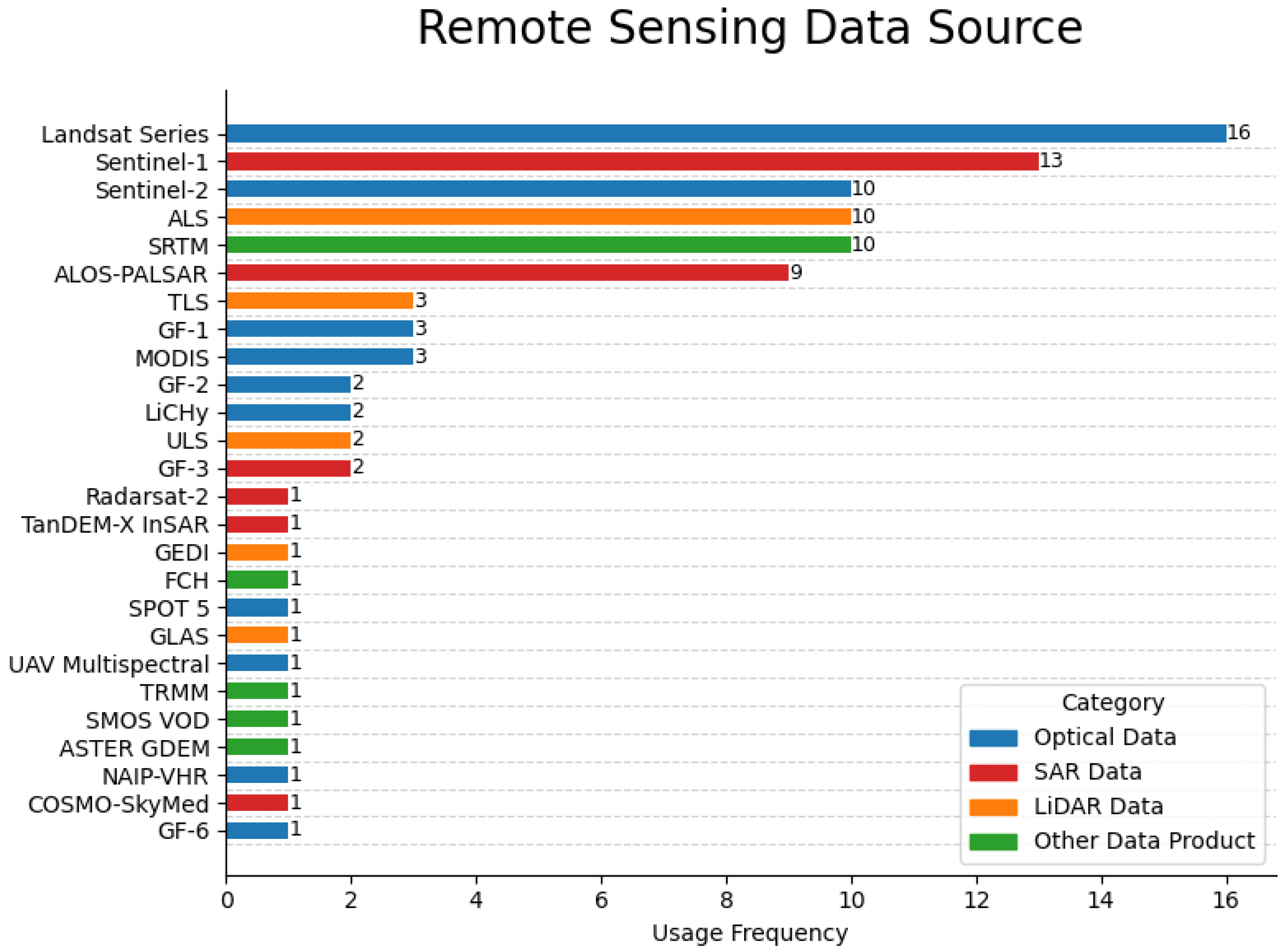
Disclaimer/Publisher’s Note: The statements, opinions and data contained in all publications are solely those of the individual author(s) and contributor(s) and not of MDPI and/or the editor(s). MDPI and/or the editor(s) disclaim responsibility for any injury to people or property resulting from any ideas, methods, instructions or products referred to in the content. |
© 2025 by the authors. Licensee MDPI, Basel, Switzerland. This article is an open access article distributed under the terms and conditions of the Creative Commons Attribution (CC BY) license (https://creativecommons.org/licenses/by/4.0/).