Article

Valuing Improved Firefighting Access for Wildfire Damage Prevention in Mediterranean Forests

by
Abdullah Emin Akay
1,*,
Neşat Erkan
1,
Ebru Bilici
2,
Zennure Ucar
3 and
Coşkun Okan Güney
4
1
Department of Forest Engineering, Faculty of Forestry, Bursa Technical University, Bursa 16310, Türkiye
2
Dereli Vocational School, Giresun University, Giresun 28950, Türkiye
3
Department of Forest Engineering, Faculty of Forestry, İzmir Katip Çelebi University, İzmir 35620, Türkiye
4
Department of Forest Fires, Aegean Forestry Research Institute, İzmir 35430, Türkiye
*
Author to whom correspondence should be addressed.
Forests 2025, 16(12), 1755; https://doi.org/10.3390/f16121755
Submission received: 10 October 2025 / Revised: 11 November 2025 / Accepted: 19 November 2025 / Published: 21 November 2025
(This article belongs to the Special Issue Advanced Methods and Technologies for Forest Wildfire Prevention)

Abstract

To effectively combat wildfires, ground teams must reach the fire site via road network within critical response time. However, low-standard forest roads can reduce firetruck speeds and delay fire response times. This study aimed to investigate how improving road standards affects firefighting access within critical response time and contributes to reducing timber losses. This study was conducted in Antalya, the city most affected by wildfires in Türkiye. In the study, highly fire-prone forests were first identified based on a fire probability map of Antalya, developed through a GIS-based MCDA model incorporating the Fuzzy-AHP method. Then, the highly fire-prone forests and their corresponding timber volume were determined. Finally, the economic value of timber saved from fire and the present net value of total road costs were determined. As a result of improving forest roads, the forest areas that could be reached in time increased by 11.04%, making an additional 81,867.53 hectare of highly fire-prone forests accessible. The amount and economic value of timber products saved in this area were 971,195.55 m3 and €37,689,301, respectively. The cost of improved roads was €37,386,622 while the resulting positive net economic value of €302,679 indicates that investing in forest roads improvements is a viable option.

1. Introduction

In the last century, rapid population growth and consumer demands have significantly increased the pressure on forest resources. The most obvious effects of this pressure on forest resources are clearing forests, illegal logging, and forest fires [1]. Forest fires severely damage forests and cause significant biological and ecological damage to forest vegetation [2]. Furthermore, fire-damaged trees become vulnerable to the impacts of external agents such as fungi [3] and insects which degrade the wood, reducing its quality and commercial value [4]. Forest fires damage approximately 500,000 hectares of forest annually in the fire-prone Mediterranean basin [5]. High temperatures, low humidity, and strong winds due to climate change are causing large forest fires. In recent years, the frequency of large forest fires in Türkiye has increased, and approximately 140,000 hectares of forest were burned in 2021. Approximately 43% of these burned areas were in the Mediterranean city of Antalya [6]. Fire behavior generally indicates that forest fires begin as blanket fires and, depending on fire parameters, evolve into crown fires, spreading over large areas [7].
To minimize the ecological and economic impacts of forest fires, areas with high probability of fire should be identified, and forest fire prevention measures should be taken in these areas [8]. The probability of a fire occurring in a forest area is the probability that a fire will start in that area, depending on the presence and impact of factors that trigger forest fires. The probability of a forest fire varies depending on factors such as stand characteristics, topographic factors, climatic parameters, and proximity to certain points [9]. Tree species, canopy closure, and stand age are the main stand characteristics that affect fire [10]. Coniferous trees, with low moisture and high resin content, are more susceptible to forest fires due to their rapid ignition potential [11]. Stands with high canopy closure (>70%) are critical for forest fires as it causes natural branch pruning, increasing dead organic material on the forest floor [12]. The probability of fire is high in young stands and low in old stands [13].
Ground slope and aspect are the main topographic features that affect the probability of forest fires [14]. Other factors being held constant, fires move fastest on steep slopes, and increasing slopes increase the spread of forest fires [15]. The probability of a fire outbreak varies by aspect, as it is influenced by temperature and humidity conditions. The likelihood of fire is relatively higher on southern exposures due to lower humidity [16]. Climate parameters that influence forest fires include average maximum temperature “°C”, average relative humidity (%), and average wind speed (m/s) and direction. While increasing temperature in forest areas causes flammable fuels to ignite more easily, low humidity increases the probability of forest fires [17]. Wind spreads fires further, making firefighting efforts more difficult. Furthermore, winds blowing from the sea increase humidity, while winds blowing from the land decrease it [17]. Human activities around the road network, residential areas, and agricultural areas potentially increase; therefore, forests close to roads, residential areas, and agricultural areas are more susceptible to fire [15].
To accurately assess areas with a high probability of forest fires, fire probability maps are produced using Geographic Information Systems (GIS) techniques using data layers representing the factors that influence the probability of fire [15]. Recent advances in GIS techniques that can be integrated with Multi-Criteria Decision Making (MCDM) analysis have made it possible to quickly and effectively develop probability maps that require the spatial analysis and conditional evaluation of numerous factors. The Analytical Hierarchy Process (AHP) is one of the MCDM methods used to solve complex spatial problems in forestry. However, the decision-making challenge in analysis of forest fire probability is characterized by uncertainty [18], and therefore, the traditional AHP method may not be sufficient for making effective decisions in fire probability mapping. To address the problem of uncertainty, which is a natural part of the decision-making process, the AHP method integrated with Fuzzy Logic was developed, allowing decision makers to determine approximate preferences through fuzzy numbers [19]. The main advantage of this method, called Fuzzy-AHP, is its ability to classify main and sub-criteria based on expert opinion and surveys when real data are not available. Integrating the Fuzzy-AHP method with GIS has been effectively used to produce suitability maps and natural disaster probability maps [20,21,22].
Reaching and responding to forest fires as quickly as possible is crucial for effective firefighting [17]. Especially in highly vulnerable areas, the time required for firefighters and ground team to reach the fire site should not exceed the critical response time, which is the most likely time to control the fire at its initial stage [23]. Forest roads are key infrastructures that provide access to forest areas for the protection of forest resources. In Türkiye, forest roads are classified into three types based on the factors such as the annual volume of forest products transported, construction purpose, traffic density, and the size and tonnage of vehicles in use: main forest roads, secondary forest roads (Type A and Type B secondary forest roads), and tractor roads [24]. Approximately 66% of forest roads in Türkiye are Type B secondary forest roads [25]. These roads meet limited standards and typically require major repairs annually to ensure continued access to forest resources. The inadequacy of technical standards (platform width, curve radius, curve width, etc.) and the lack of engineering structures and superstructures of B-type secondary forest roads negatively impact vehicle traffic [26].
Increasing the design speed of forest roads by improving their technical standards will significantly contribute to expanding accessible forest areas within the critical response time and reducing economic losses from fire-damaged wood raw materials. Preliminary studies on this topic have shown that improving forest road standards will significantly increase accessible forest areas within the critical response time [4]. The Network Analyst module in ArcGIS 10.8 (Esri, Redlands, CA, USA) is widely used to determine the optimal route that will provide the fastest access from forest fire stations to a potential fire site [27,28,29,30,31].
Although improving road standards may lead to additional costs during the construction phase, maintenance and repair costs are significantly reduced in the long term [25]. To determine the economic consequences of improving road standards, it is necessary to calculate both the cost of the road improvements and the economic value losses in forests that are likely to be damaged by fire due to failure to reach these areas in a timely manner. The cost of road improvement activities can be determined based on the total length of forest roads and current unit costs [25]. The extent of damage resulting from forest fires can be determined depending on the forest management purpose. Especially if the management purpose is wood production, total economic losses can be calculated based on wood product losses caused by fire and market prices [4]. In cases where the forest is completely burned and must be regenerated or reforested, the mean annual increment (MAI) loss over the stand’s age must also be taken into account. Even when the remaining trees in the burned area are subject to wood production, there is still a production loss due to harvesting earlier than the end of its rotation period [4].
This study evaluated the effects of improving the standards of B-type secondary forest roads in terms of increasing the forest areas accessible by initial response teams (including mobile ground teams) during the critical response time, especially in forests with a high probability of fire. From an operational perspective, wood raw material production, one of the most important commercial functions of forests in Türkiye, is among the elements most affected by the damage resulting from delays in responding to forest fires. Therefore, this study aimed to investigate the effects of improving forest road standards on reduction in economic losses related to wood raw material potentially saved from the forest fire. In the solution phase, a fire probability map developed by the Fuzzy-AHP method integrated with GIS techniques was used to identify forest areas with a high probability of fire within the study area [32]. Then, using network analysis-based GIS techniques, forest areas with high probability of fire accessible within the critical response time for both existing roads and roads with improved standards were identified, and the potential economic consequences of improving road standards were examined. The cost of improving road standards was calculated based on the annual maintenance cost and the cost of road improvement activities. The economic gain from additional accessible forests saved from fire in the improved road standards scenario was then determined, taking into account the wood raw material in these areas.
This study builds on the general approach used in previous studies but incorporates significant innovations in both methodological and practical aspects. Unlike previous studies, this study not only assesses spatial accessibility but also analyzes the impact of improving road standards on firefighting effectiveness, wood raw material losses, and road costs within a holistic economic framework. In this context, a new methodological framework is proposed that integrates the Fuzzy-AHP-based fire probability model with a network analysis-based accessibility assessment and economic valuation approach. This integrated analysis, conducted with data specific to conditions in Mediterranean forest ecosystem, offers a new assessment approach that can quantitatively guide decision-makers in assessing forest road improvements for fire prevention strategies and economic sustainability. The proposed methodological framework can also be applied to forest ecosystems in other regions of the world, provided appropriate spatial and economic data are available.

2. Materials and Methods

2.1. Study Area

The Antalya Regional Directorate of Forestry (RDF) was selected as the study area, where first- and second-degree fire-sensitive forests are widespread (Figure 1). In the Antalya RDF, which has the largest burned forest area in Türkiye, 74,520 forest fires occurred between 1988 and 2022, damaging approximately 500,000 hectares [33]. There are 120 Forest Enterprise Chiefs under 14 Forest Enterprise Directorates (FED) within the borders of the Antalya RDF. The total area of the Antalya RDF is approximately two million hectares, approximately 55% of which is covered by forests. Antalya is under the influence of the Mediterranean climate, and the region experiences hot and dry summers. The forest stands are dominated by coniferous trees, including brutian pine (Pinus brutia), juniper (Juniperus sp.), cedar (Cedrus libani), oak (Quercus sp.), taurus fir (Abies cilicica), and black pine (Pinus nigra). In the Antalya region, one of the most important tourism centers of Türkiye, the tourism and recreation services are intensely in progress during the tourist season [34]. This seasonal increase in population coincides with the peak of the fire season, typically marked by hot, dry weather and strong winds. The increased human presence in forests, national parks, and rural areas raises the probability of forest fires, whether from unattended campfires, discarded cigarette butts, or other negligent behaviors.

2.2. Development of the Fire Probability Map

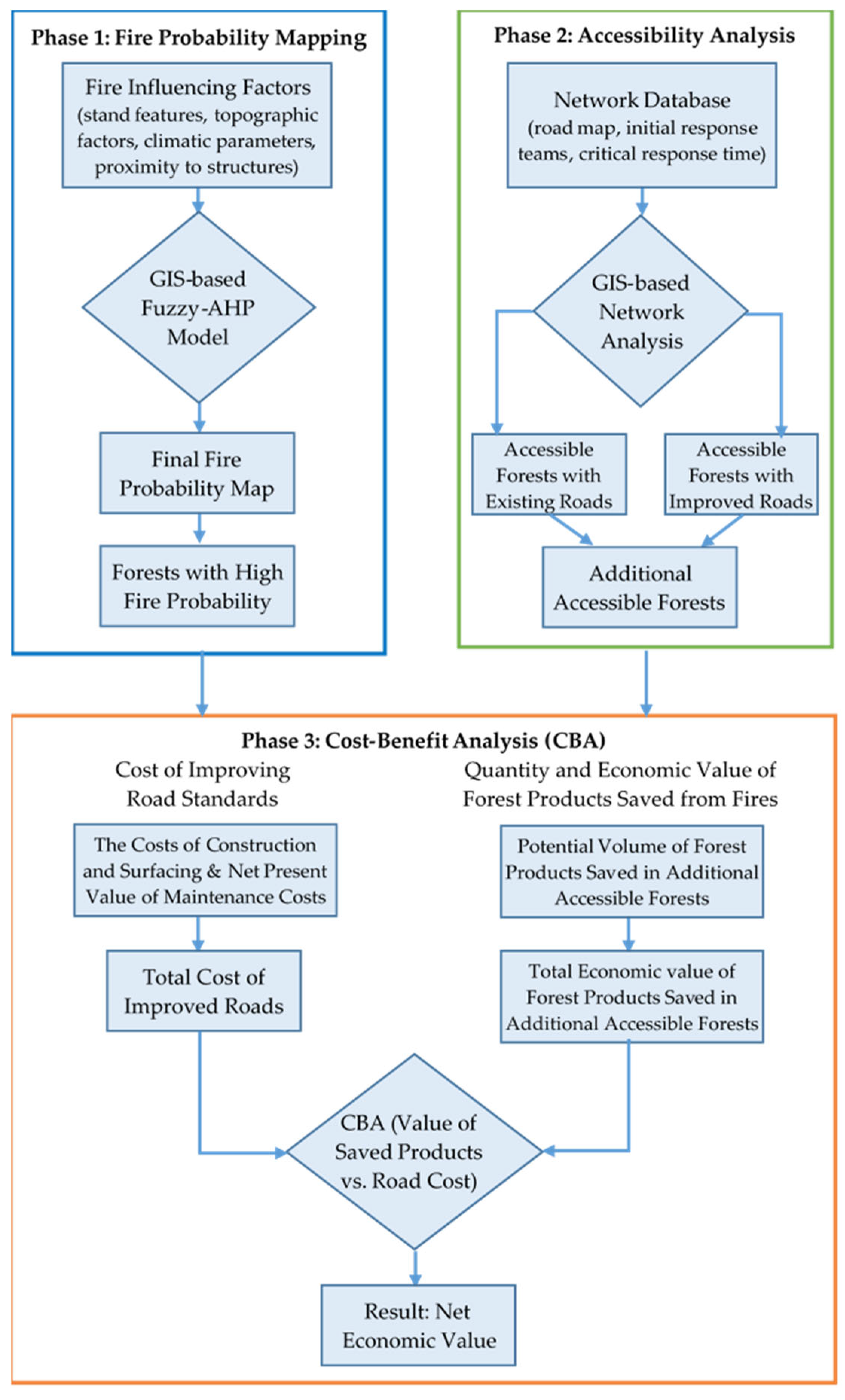
The first phase of the methodology involves identifying the forests highly susceptible to forest fires, followed subsequent analysis including quantifying the contribution of improving the standards of forest roads to expanding accessible forest areas, calculating the cost of improving road standards for forest roads, determining the economic value of wood-based forest products saved from fires by improving road standards, and finally calculating the net economic value from improving forest road standards. The flowchart of the methodology is indicated in Figure 2.
The forest fire probability map was derived by implementing a Fuzzy-AHP integrated with GIS, utilizing geospatial data representing fire influencing factors. The Fuzzy-AHP method was chosen instead of the traditional AHP, due to its ability to handle the uncertainty in expert judgments during the weighting of fire-influencing factors. A comprehensive description of the methodology applied to generate the fire probability map is provided in Uçar et al. [32]. In the current study, the methodology was outlined in its main aspects in this section.

2.2.1. Fire Influencing Factors

In the production of a fire influencing map, factors affecting fire were grouped under four main criteria: stand characteristics (tree species, canopy closure, and stand ages), topographic factors (slope, aspect), climatic parameters (temperature, relative humidity, wind speed, and precipitation), and proximity to anthropogenic structures (road network, residential areas, agricultural areas). A data layer representing only forest areas in the study area was generated using a stand type map obtained from the management plans of the FEDs. Then, considering the forest areas, digital data layers (100 m × 100 m) representing fire influencing factors were generated and divided into classes (sub-criteria) based on fire probability levels. Data layers for stand characteristics were generated using the stand type map. First, the stand type map was divided into five classes (very low, low, medium, high, and very high) based on the sensitivity of tree species/species compositions to forest fires [10]. A canopy closure map was then generated for the study area and divided into four classes: bare land (degraded) (0%–10%), sparse (11%–40%), moderate (41%–70%), and dense (>70%). Finally, the stand age map was divided into five classes based on tree diameters recommended by the national forest management system: young: (<0–8 cm), middle-aged: (8–19.9 cm), maturing (20–35.9 cm), mature (36–51.9 cm) and over mature (>52 cm) [32].
Slope and aspect maps were produced for the forest area using the Digital Elevation Model (DEM) obtained from the Antalya RDF. The slope map was divided into five classes: gentle (0%–5%), low (5%–15%), moderate (15%–25%), high (25%–35%), and steep (>35%) [15]. The aspect map was divided into nine classes: flat, north (N), northeast (NE), east (E), south (S), southeast (SE), southwest (SW), west (W), and northwest (NW). The Canadian Fire Weather Index System (FWI) was used to determine the effects of climate parameters on probability of forest fire [32]. While calculating FWI, the data of 19 meteorological stations within the Antalya RDF between 2001–2021 were obtained from the Antalya Regional Directorate of Meteorology. The FWI map for the forest area was produced based on the FWI values, ranging between 23.89 and 29.21 in the study area, were divided into four classes (<24, 24–26, 26–28, and >28). Considering that fire probability increases in areas close to settlements due to the intensity of human activities, road networks, distances to residential areas, and agricultural areas were evaluated in determining the probability of fire in forest areas. Data layers for residential areas and agricultural areas were generated using stand maps. Road network data from the Antalya RDF were obtained, and some newly constructed road sections were digitized based on satellite imagery. Then, buffer zones (100 m, 200 m, 300 m, 400 m, and >400 m) were generated around these anthropogenic structures [32].

2.2.2. Weighting of Memberships and Defuzzification

After classifying fire influencing factors, a fire probability score between 1 and 10 was assigned to each class. In this context, 1 represents the best value (lowest probability), while 10 represents the worst value (highest probability). To ensure inclusion in the GIS-based model (Fuzzy-AHP), four fire probability level (low, medium, high, and very high) were defined for the fire influencing factors assigned as decision variables in the objective function. The weighted values for each class of fire influencing factors were calculated using a regression equation estimation model [35]. The raster data layer generated for each fire influencing factor was reclassified by taking into account the percentage weights of the fire probability scores. Then, membership values between 0 and 1 were assigned to the criteria using Fuzzy Logic membership functions (e.g., Gaussian, Small, Large, Near, MSSmall, MSLarge, Linear). Based on the weighted values of the fire influencing factors, the membership type with the highest R2 value was selected (Table 1).
To determine the fuzzy-AHP weights of the fire influencing factors, pairwise comparison matrices were developed and the fuzzy geometric mean method was used [36]. To analyze the consistency of the pairwise comparison matrices, the consistency ratio (CR) was tested [37]. Then, in ArcGIS 10.8 (Esri, Redlands, CA, USA), the weighted memberships of the fire influencing factors were obtained by multiplying the normalized weight values of the factors with the membership data layers. In the final stage, a defuzzification process was performed to assign the weighted memberships of the fire influencing factors to a single value [38]. In performing the defuzzification process, a fire probability map was produced for five defuzzification methods (“AND”, “OR”, “PRODUCT”, “SUM”, and “GAMMA”) using Fuzzy Overlay tool available in ArcGIS 10.8 (Esri, Redlands, CA, USA) [39].

2.2.3. Accuracy of Fire Probability Maps

The spatial distribution of forest fires that occurred between 2001 and 2021 in the study area were obtained from Antalya RDF to validate the maps developed using five defuzzification methods. The ROC (Receiver Operating Characteristic) curve method [40] was used to test the accuracy of these maps based on the burned areas larger than 0.5 ha (964 cases) in the study area. The area under the curve is called the “Area Under Curve” (AUC) and is used to evaluate the statistical performance of the ROC curve’s predictive ability. The AUC value is divided into five categories: weak (0.5–0.6); medium (0.6–0.7); good (0.7–0.8); very good (0.8–0.9) and excellent (0.9–1.0). The accuracy of fire probability maps was tested using the “ROC_ArcSDM” extension in ArcGIS 10.8 (Esri, Redlands, CA, USA) environment.

2.3. Determining Accessible Forest Areas

This phase evaluated the potential contribution of improving the standards of Type B secondary forest roads to expanding accessible forest areas with a high fire probability during the critical response time. To effectively respond to forest fires, the time required for initial response team to reach the fire site should not exceed the critical response time. Critical response time varies depending on the fire sensitivity level of the burned area [23] (Table 2). The fire sensitivity level of a region is determined based on the number of fires and the ratio of the burned area to the forest area of the enterprise directorate [41]. A fire sensitivity layer was generated for forest areas within the Antalya RDF, based on the forest fire sensitivity map developed by GDF for the FEDs in Türkiye [42].
A new field data showing the average travel time of fire truck carrying initial response team was added to the attribute table of the improved road network layer for each road section. Travel time of the fire truck is calculated based the road type, the road distance, and the average speed of the fire truck. The road types in the study area are classified into three groups based on the road pavement material: asphalt, gravel, and B-type secondary forest roads. Average fire truck speeds by road types were determined by taking into account the vehicle speed information suggested by previous studies [4]. In light of this information, the average fire truck speeds for asphalt, gravel, and B-type secondary forest roads were taken as 60 km/h, 50 km/h, and 30 km/h, respectively. In determining the forested areas that could be reached during the critical response time for the improved B-type secondary forest roads, the average fire truck speed was assumed to be 40 km/h [4]. The travel time was recalculated in the improved road network layer based on road distance and the average speed of the vehicle.
In the initial phase of the analysis, the forest areas with a high probability of fire that can be reached by initial response teams within the critical response time were identified, taking into account the existing road network in the study area. In the second scenario, the potential increase in accessible forest areas with a high probability of fire was determined considering forest roads with improved standards allowing for higher vehicle speeds. The New Service Area method, based on network analysis under the Network Analyst module in ArcGIS 10.8 (Esri, Redlands, CA, USA), was used to determine the forest areas accessible during the critical response time for both scenarios [29]. In this method, the location of the initial response team was considered as a central point from which other parts of the network could be reached within the total link value defined in this study as the critical response time. The New Service Area method was used because, unlike simple straight-line distances, it is specifically designed to model travel impedance along a network, providing a realistic calculation of areas accessible within a constant time period. Data on initial response teams (including mobile ground teams) in the study area were obtained from Antalya RDF and verified through field visits. Then, a digital data layer containing initial response teams was generated in ArcGIS 10.8 (Esri, Redlands, CA, USA). There are a total of 174 initial response teams in the study area, 103 of whom are stationary teams and 71 are mobile ground teams.

2.4. Determining the Economic Consequences of Improving Road Standards

To estimate the economic consequences of improving road standards, first, the cost of improving road standards for forest roads within the total accessible area in the second scenario was calculated. Then, the quantity and economic value of wood-based forest products in forests saved from forest fires by improving road standards were determined. Finally, the net economic value derived from improving forest road standards was calculated. The economic consequences of improving forest road standards were determined by using a cost–benefit analysis (CBA) approach will be described in this section. This method was chosen because it provides a systematic framework for quantifying both the costs and the potential economic gains of management actions.

2.4.1. Determining the Cost of Improving Road Standards

In the second scenario, the cost of road improvement activities was determined based on the total length of forest roads within accessible areas and the unit cost of road construction. In this context, the cost of road improvement construction and surface construction activities, which are considered major repairs for road sections, was calculated. Current unit costs were used for each work package during road improvement construction. Road surface construction costs were determined based on road dimensions, amount of surface material (30 cm pavement thickness), and the cost of road surface work. Surface construction costs were also determined using current unit costs. Then, the net present value of the total cost of annual general maintenance-repair activities was calculated by taking into account the annual average general maintenance-repair unit cost (9.46 €/km), the average economic life of forest roads (30 years), and the discount rate (3%). The unit costs of road construction and maintenance activities were obtained from Antalya RDF (Table 3 and Table 4). Finally, the total cost of improved roads was calculated by taking into account the one-time cost of road improvement activities (road improvement construction and surface construction) and the net present value of the annual maintenance-repair cost for the economic life of forest roads.
In addition to annual general maintenance-repair activities for existing forest roads, major repairs are carried out depending on weather conditions and road usage. The cost of major repairs for existing roads was determined based on the total road length and the current unit major repair cost (810.81 €/km). The net present value of the total cost of existing roads (major repairs and maintenance-repair costs) was then determined and compared with the total improvement cost of the improved roads (one-time road improvement cost, surface cost, and net present value of maintenance-repair costs). The calculations were based on 2024 unit prices.

2.4.2. Determining the Quantity and Economic Value of Forest Products Saved from Fires

The quantity and economic value of wood products potentially saved from fires were determined in additional areas with a high probability of forest fire, which were reached on time as a result of improving forest roads in the study area. For this purpose, calculations for the additionally reached forest areas were performed on a per-directorate basis using the methodology presented by Erkan et al. [4]. The subsequent section delineates this methodological framework, outlining its principal components and procedural aspects.
The wood loss in burned forest areas has been grouped into two categories. The first category includes losses resulting from trees completely burned in the fire. This particularly occurs in young forests during crown fires, where the trees with thin stems has been damaged to the extent that it is no longer usable. While damage is related to factors such as depth of burn, it is primarily dependent on tree diameter. Based on previous fire observations and experiences in the study area, stands with stem diameters smaller than 14 cm in conifers and 10 cm in deciduous species were assumed to have been damaged to such an extent that they could not benefit from the fire. These thresholds were determined through field surveys, measurements, and interviews with experts from the Antalya RDF. The second category of fire-induced wood loss is the reduction in MAI resulting from earlier harvesting than the end of rotation period of related stands. The highest wood yield is achieved in forest management at the rotation age when the MAI increase is at its maximum, and the GDF also applies this method in case of aiming wood production. Early or late harvesting leads to a decrease in yield and, consequently, wood production losses. These losses occur in quantity rather than quality because the wood can be cut and sold without damage; indeed, fire does not significantly reduce the economic value of thick logs [43,44].
On the other hand, the second type of loss described above, which occurs in burned areas, can evident as either losses or gains, depending on the forest management objective and, consequently, the rotation period. In forest management, the highest wood yield is obtained during the rotation period corresponding to the age at which the MAI is maximum. To calculate increment losses in burned areas, MAI per hectare were determined from yield tables for each tree species based on the age in the year of the fire, site class, and degree of canopy closure [45,46,47,48,49]. Normal yield tables were used in these calculations, and then, for the no-fire scenario, MAI per hectare were calculated based on the rotation period length specified in the management plan.
In the absence of fire damage, an amount of MAI expected per hectare, based on the site class and rotation age specified in the management plan. However, when early harvesting occurs due to fire, growth is only up to the age of the fire year. Total growth loss is calculated by multiplying the MAI loss per hectare due to early harvest by the area of the relevant stand and its age at the fire year [4]. In the calculations, for determination of increment for a stand type, the MAI value obtained from the regression equation derived from yield tables based on age and site class was multiplied by the degree of crown closure. The data used for the calculations were obtained from management plans of the related forest.
In forests managed for purposes other than wood production, rotation ages are generally greater than that of managed for wood production (Table 5). From a wood production gain/loss perspective, forests managed with longer rotation periods may have a wood production gain, depending on the stand age at the time of the fire, because the MAI in a fire year will be higher than that of expected for the longer rotation period projected in the plan.

2.4.3. Determining the Net Economic Value Achieved by Improving Road Standards

The economic value of wood-based forest products in additional forest areas potentially saved from fire as a result of improving forest roads was determined using 2024 market prices. First, the types and economic values of the saved forest products were determined. For brutian pine, black pine, cedar, juniper, and taurus fir, the product type tables prepared by Sun et al. [50] for main tree species were used to determine the product types. For oak, the results of the research conducted by Şahin et al. [51] were utilized. Regression models (equations) based on mean stand diameter were derived from these tables for the wood product ratios given according to stand mean diameter and these models (equations) were used to calculate the product types. The economic value of each product type was then calculated based on market unit prices. Average market sales prices for product types by tree species in 2024 were obtained from the Business Marketing Department of GDF. Finally, the total economic value of forest products for forest areas saved from fire was calculated by summing the market values of the products.
In the final stage, to determine the net economic value generated by improving forest roads, the total cost of improving road standards was subtracted from the economic value of forest products in forest areas potentially saved from forest fire. The total road cost included the one-time cost of road improvement activities (road improvement construction and surface construction) and the net present value of total annual maintenance-repair costs. A positive outcome of the evaluation signifies that the investment project is considered viable.

3. Results

3.1. Additional Accessible Forest Areas

At this stage, by improving the standards of Type B secondary forest roads, additional accessible forest areas with a high probability of forest fire during the critical response time were identified. First, fire probability maps were produced for the Antalya RDF using the Fuzzy-AHP method to identify forests with a high probability of fire. According to the results, the AUC values of the fire probability maps developed with the “AND”, “OR”, “SUM”, and “GAMMA” defuzzification types were determined as 0.59, 0.73, 0.71, and 0.69, respectively [32]. “PRODUCT” did not yield satisfactory results. A data layer representing forest areas with a high probability of forest fire was generated using the “OR” defuzzification type-based fire probability map, which was selected based on the AUC value and expert opinions.
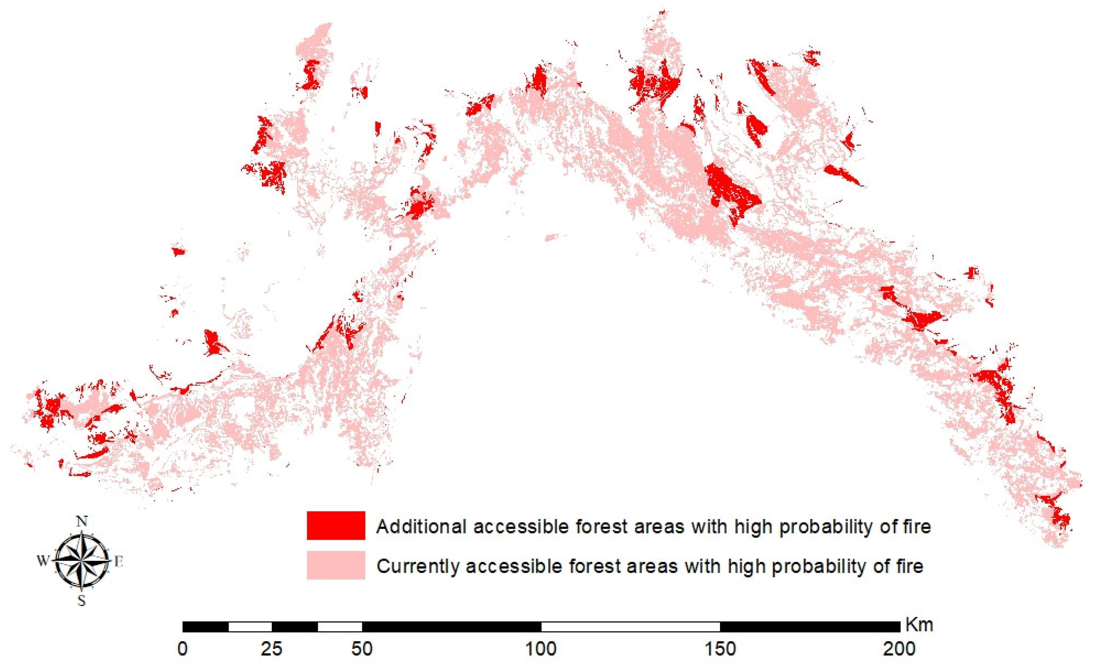
In the next stage, the forest areas accessible within the critical response time were determined for the scenario where existing Type B secondary forest roads were evaluated. The results indicated that 70.40% of the forests within the Antalya RDF could be reached within the critical response time. In the second scenario, which evaluated forest roads with improved standards, 78.17% of the forests were reached on time. These results indicated an 11.04% increase in accessible forest areas compared to the scenario where existing roads were evaluated. Then, by overlaying the data layer containing accessible forest areas in the second scenario with the data layer containing forest areas with a high probability of forest fire in ArcGIS 10.8 (Esri, Redlands, CA, USA), additional accessible forest areas with a high fire probability (81,867.53 hectares) were determined if road standards were improved (Figure 3). The amounts of forest area that could be saved by tree species and FEDs as a result of road improvements are given in Table 6. The stone pine (9.60 ha) and cypress (0.47 ha) areas, which were saved from the fire and were in very small amounts, were evaluated within the brutian pine forests. Similarly, species with low quantities found in the saved forest area—such as platanus, bay tree, carob, and olive—were grouped under the category “Other deciduous species”. Furthermore, the Lütfi Büyükyıldırım Research Forest, within the Antalya RDF, was included in the Korkuteli FED; the Beydağları National Park in the Kumluca FED; the Güllükdağı National Park in the Konyaaltı FED; and the Köprülü Canyon National Park in the Manavgat FED.

3.2. Cost of Improving Road Standards and the Net Economic Value Achieved

The amount of wood-based forest products saved in additional forest areas accessed after road improvements was calculated by FEDs, taking into account characteristics such as (i) tree species, (ii) stand age, (iii) canopy closure, and (iv) site class (Table 7). In the study, calculations were made by taking into account the current situation in the forest management plans, and the gains provided by road improvement in the context of wood production for the sections operated with long rotation periods were calculated as negative (−) results. This situation occurred more frequently in areas allocated to purposes other than wood production and occupied by tree species other than brutian pine. The total economic value of wood-based forest products in additional areas saved through road improvements in the study area was calculated. According to the results, the economic value of the forest products potentially saved from fire was €37,689,301 (Table 8).
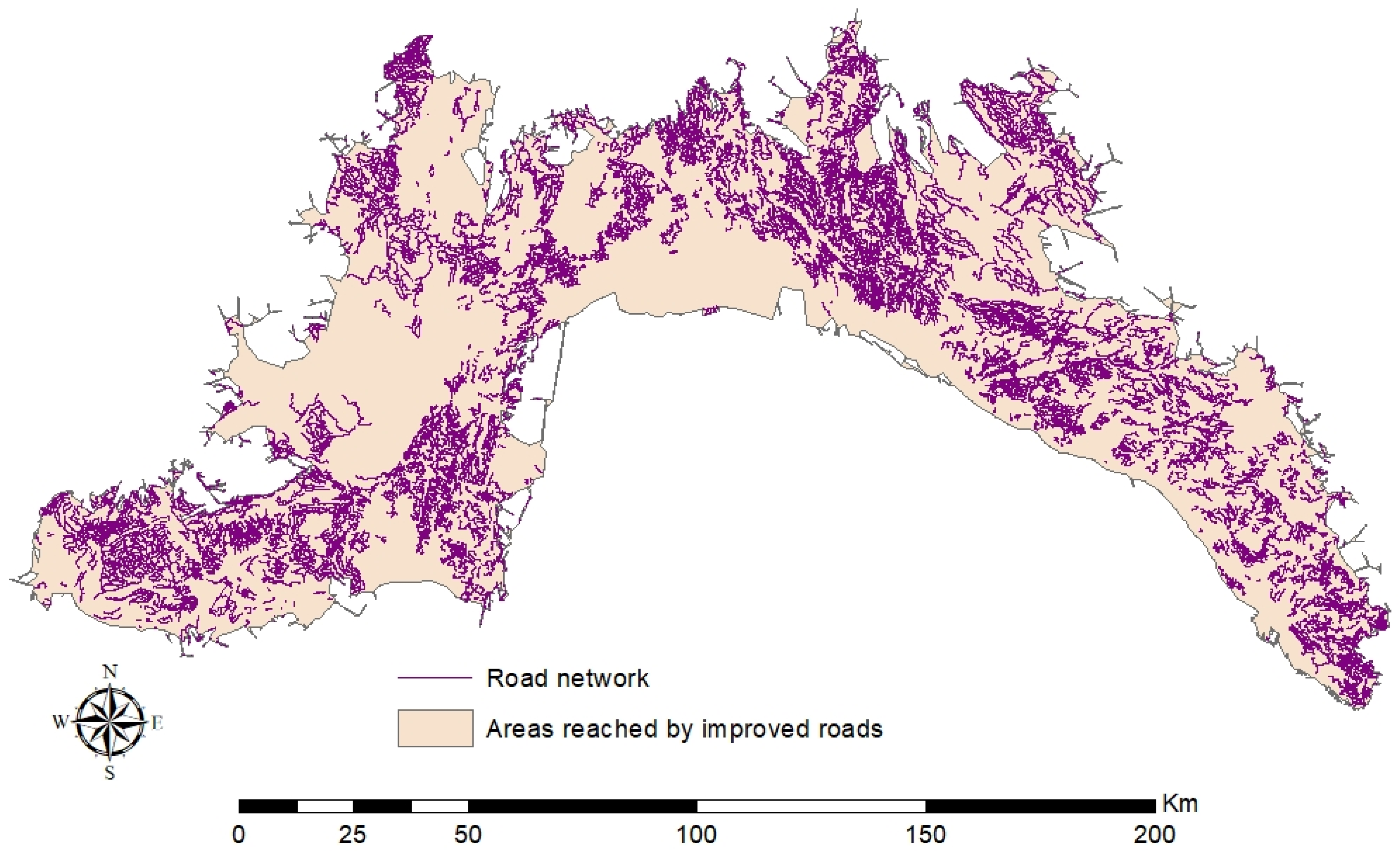
In the second scenario, road improvement construction and surface construction costs were determined based on the total length of forest roads within accessible areas and current unit road construction costs. The total length of forest roads subject to improvement within the scope of the study was determined as 17,292.72 km (Figure 4). According to the results, the road improvement construction and surface construction costs were €34,055,946 and €2,800,122, respectively, and the total one-time cost of road improvement activities was €36,856,068.
For both road conditions, the overall maintenance-repair cost was determined using the annual average maintenance-repair unit cost and the total road length. Accordingly, the annual overall maintenance-repair cost was determined as €163,580. Finally, the total cost of the improved roads was calculated by summing the one-time cost of road improvement activities (road improvement construction and surface construction) and the net present value of the annual overall maintenance-repair cost. Accordingly, the net present value of the maintenance-repair cost was found to be €530,554, and the total cost of the improved roads was found to be €37,386,622.
The total cost of existing forest roads was calculated by summing the annual general maintenance-repair cost and the net present value of the cost of major repair activities. Accordingly, the total cost of existing roads was found to be €46,006,634. The results showed that improving road standards would reduce road costs by 18.74% compared to the current situation. In the final stage, to determine the net economic value provided by improving forest roads, the total cost of road improvements (€37,386,622) was subtracted from the total economic value of wood-based forest products in forest areas saved from fire (€37,689,301). The positive result (€302,679) indicated that investment projects aimed at improving forest roads were acceptable.

4. Discussion

The ability of initial response team to reach the fire area within the critical response time is crucial for firefighting operations [52,53]. Improving road standards will allow initial response team to reach more areas in a timely manner due to increased design speed. This study examined the contribution of improving the standards of B-type secondary forest roads to increase the forest areas accessible to initial response team within the critical response time in forests with high probability of fire. In this context, the economic value of wood-based forest products potentially saved from forests with high probability of fire, where additional access was provided after improving road standards, was estimated. According to the forest fire probability map developed for the Antalya RDF using the GIS-based Fuzzy-AHP method, 61.64% of the forests had a high probability of forest fire [32].
According to the results of the New Service Area method, improving road standards increased the forest area that could be reached within the critical response time by 11.04%. The additional accessible forest area with a high probability of fire was determined to be 81,867.53 hectares. A study conducted by Podolskaia et al. [54] evaluated road data sources for regional forest fire management and emphasized the importance of accurately generating and updating road data sets. In a study evaluating the contribution of improving forest road standards to increasing accessible forest areas [25], the forest areas that could be reached by initial response team in the study area during the critical response time were determined. According to the results, with improving forest road standards, the proportion of accessible forest area during the critical response time increased from 17% to 36%. A recent study conducted by Erkan et al. [31] showed that 44% of forest areas could be reached within the critical response time for existing roads, while accessible forest areas increased to 55% on improved roads.
On the other hand, it can be assumed that the improvement activities of existing B-type secondary forest roads will incur a cost. The results show that, considering the economic life of the roads, the improvement activities will not increase the total road cost; on the contrary, they will save €8,620,012 in the long run. This supports the view that construction costs will increase for high-standard roads, but road maintenance-repair costs will be much lower [24]. The study also estimated the amount and economic value of wood-based forest products that can be obtained from forest areas where firefighting capabilities are increased by improving road standards. In this context, it is assumed that fires that were intervened with appropriate equipment and teams within the critical timeframe were extinguished. The total amount of wood-based forest products potentially saved in additional forest areas reached after road improvement was calculated as 971,195.55 m3. The gains in wood production from road improvement for sections operated with long rotation periods were determined to be negative (−) results. According to the results, the amount of salvaged forest products was calculated as 731,104.16 m3, 160,727.95 m3, 48,241.94 m3, −8374.34 m3, 46,746.20 m3 and −7259.36 m3 for brutian pine, black pine, cedar, juniper, taurus fir and oak, respectively. The total economic value of the salvaged wood-based forest products was found to be €37,689,301.
In forests not allocated to wood production, rotation periods are generally extended beyond the maximum annual volume increment age. Because fires cause early tree-felling in these areas, higher yields can sometimes be achieved. Conversely, because rotation periods in areas allocated to wood production are determined by the maximum growth age, protecting these areas from fire generally results in yield gains [55]. This has been observed particularly in black pine, cedar, juniper, and oak forests allocated to non-wood functions. Furthermore, forest fire response varies depending on the fire resistance of species and stand mixes [56]. However, saving an area from fire does not always result in greater yield gains. In some cases, post-fire yields can be higher depending on the tree species, rotation period, and forest function. Especially if annual volume increment at the stand age is higher than the planned rotation period, the area saved from fire can actually lead to a loss of wood yield.
In the final stage, when the total economic value was compared with the total cost of road improvements, the net economic value was positive (€302,679), and therefore, it was predicted that investment in improving forest road standards would be appropriate. In addition to the economic loss of wood-based forest products caused by forest fires, there are also costs not included in this study, such as the cost of pre-fire activities, fire suppression costs, material damage, and other socio-economic losses. Therefore, it should also be taken into account that fires, along with climate change, can cause significant negative impacts and social costs [57,58,59,60].
In recent years, advanced remote sensing techniques integrated with deep learning methods has demonstrated great potential in enhancing spatial pattern recognition. Particularly in mountainous regions with rough terrain, analysis methods based on multilayer deep neural networks and multiple feature constraints provide significant accuracy improvements in spatial feature recognition and classification [61]. Similarly, models developed by integrating multi-source remote sensing data also demonstrate high performance in disaster management, land use change, and environmental risk assessments [62]. In this context, combining traditional GIS-based methods used in forest fire risk analysis with deep learning-supported contextual analysis models has the potential to significantly increase spatial accuracy and early warning capacity.

5. Conclusions

In this study, the improvement of B-type secondary forest road standards was evaluated in terms of its impact on increasing the accessibility of forest areas within the critical response time, particularly in fire-prone forests in the Mediterranean city of Antalya. A forest fire probability map was developed for the Antalya RDF using the Fuzzy-AHP method. The fire probability map showed that a significant portion of the forested areas in the study area are located in zone with very high probability of forest fires. One of the most critical fire prevention strategies to reduce the probability of forest fires will be the establishment of fire-resistant forests from species naturally distributed in the Mediterranean region. Furthermore, mixed stands of coniferous and deciduous species are an effective forestry practice for reducing forest fires.
To minimize the impacts of forest fires on forest ecosystems, initial response teams should reach the fire zone as quickly as possible via ground transportation. In this study, additional forest areas that initial response teams can reach within the critical response time in case of improvement of B-type secondary forest roads in Antalya RDF were determined. The results showed that road improvements increased the forest area accessible within the critical response time by 11.04%. In light of this data, it is evident that improving the standards of existing roads, thereby increasing their design speed, will significantly enhance the effectiveness of wildfire response. The construction of new road networks, particularly in forested areas in mountainous regions, is not always feasible due to economic and ecological constraints. Therefore, improving the technical standards of forest roads and increasing the design speed will significantly contribute to expanding the accessible forest areas within the critical response time.
On the other hand, the cost of improving existing B-type secondary forest roads should be carefully analyzed. In this study, the total cost of road improvement activities was found to be €37,386,622. The economic value of wood-based forest products that could be saved from forest fires through the improvement of forest road standards has been estimated as €37,689,301. Accordingly, improving forest road standards is considered as an economically viable investment for the Antalya RDF. Therefore, improving road standards will significantly contribute to the effectiveness of firefighting activities and reduce the economic loss of forest products obtained from forests. However, considering that road improvements can have negative consequences depending on the management purpose, particularly in long-term forests allocated for purposes other than wood production, also depending on the age of the stand at the time of the fire, it would be more appropriate to prioritize forests for wood production in road improvement projects.
Future studies should focus on optimizing the spatial deployment of initial response teams, planning efficient Unmanned Aerial Vehicle (UAV) routes for real-time fire monitoring, and improving coordination between ground and aerial firefighting units to enhance overall wildfire response efficiency. Finally, if the construction of new roads is considered to expand accessible areas, it is important to evaluate their ecological impacts and assess how they improve accessibility to larger forest areas within the critical response time. It is highly anticipated that exploring these aspects in future research will provide a more comprehensive understanding of how technological and organizational improvements can jointly contribute to minimizing wildfire impacts in forest ecosystems.

Author Contributions

Conceptualization, A.E.A. and N.E.; methodology, A.E.A., N.E., E.B., Z.U. and C.O.G.; software, A.E.A. and Z.U.; validation, A.E.A., N.E. and Z.U.; formal analysis, A.E.A., N.E., E.B., Z.U. and C.O.G.; investigation, A.E.A., N.E., E.B., Z.U. and C.O.G.; resources, A.E.A., N.E. and C.O.G.; data curation, A.E.A., N.E. and Z.U.; writing—original draft preparation, A.E.A., N.E., E.B., Z.U. and C.O.G.; writing—review and editing, A.E.A. and N.E.; visualization, A.E.A. and Z.U.; supervision, A.E.A. and N.E. All authors have read and agreed to the published version of the manuscript.

Funding

This research received supported by The Scientific and Technological Research Council of Türkiye (TUBITAK, Grant number: 2210309).

Data Availability Statement

Data are unavailable due to privacy restrictions.

Acknowledgments

The authors acknowledge the support of TUBITAK under Grant No. 2210309.

Conflicts of Interest

The authors declare no conflicts of interest.

References

  1. Ertuğrul, M. The Situation of forest fires in the world and in Turkey. ZKU Bartin Fac. For. J. 2005, 7, 43–50. [Google Scholar]
  2. Karya, D.; Hasan, H.; Kadir, E.A. Impact of forest fire to economic and environment in Riau Province Indonesia. Int. Bus. Manag. 2017, 11, 474–477. [Google Scholar]
  3. Muşat, E.C. Impact of forest fires on the trees and wood quality—A case study for a beech stand. Fire 2019, 7, 325. [Google Scholar] [CrossRef]
  4. Erkan, N.; Akay, A.E.; Bilici, E.; Uçar, Z.; Güney, C.O. Estimating the economic value of timber products potentially saved from wildfires by improving forest road standards. Int. J. For. Eng. 2024, 35, 179–188. [Google Scholar] [CrossRef]
  5. Doerr, S.H.; Santín, C. Global trends in wildfire and its impacts: Perceptions versus realities in a changing world. Trans. R. Soc. B 2016, 371, 20150345. [Google Scholar] [CrossRef]
  6. GDF. General Directorate of Forestry 2021 Activity Report; General Directorate of Forestry: Ankara, Türkiye, 2021.
  7. Küçük, Ö.; Bilgili, E.; Durmaz, B.D.; Sağlam, B.; Baysal, İ. The effect factors on transition from surface fire to crown fire. Kastamonu Univ. J. For. Fac. 2009, 9, 80–85. [Google Scholar]
  8. Oliveira, S.; Oehler, F.; San-Miguel-Ayanz, J.; Camia, A.; Pereira, J.M.C. Modeling spatial patterns of fire occurrence in Mediterranean Europe using Multiple Regression and Random Forest. Forest. For. Ecol. Manag. 2012, 275, 117–129. [Google Scholar] [CrossRef]
  9. Carmel, Y.; Paz, S.; Jahashan, F.; Shoshany, M. Assessing fire risk using Monte Carlo simulations of fire spread. Forest Ecol. Manag. 2009, 257, 370–377. [Google Scholar] [CrossRef]
  10. Gao, X.; Fei, X.; Xie, H. Forest fire risk zone evaluation based on high spatial resolution RS image in Liangyungang Huaguo Mountain Scenic Spot. In Proceedings of the IEEE International Conference on Spatial Data Mining and Geographical Knowledge Services., Fuzhou, China, 29 June–1 July 2011. [Google Scholar]
  11. Gazzard, R. Risk Management Control Measure: Toolkit for Practitioners and Advisors. UK Vegetation Fire Risk Management. 2012; 24p. Available online: http://news.bbc.co.uk/2/shared/bsp/hi/pdfs/10_10_12_fire_control_measures.pdf (accessed on 12 July 2025).
  12. Colak, E.; Sunar, F. Evaluation of forest fire risk in the Mediterranean Turkish forests: A case study of Menderes region, Izmir. Int. J. Disaster Risk Reduct. 2020, 45, 101479. [Google Scholar] [CrossRef]
  13. Saglam, B.; Bilgili, E.; Dincdurmaz, B.; Kadiogulari, A.I.; Kucuk, O. Spatio-temporal analysis of forest fire risk and danger using LANDSAT imagery. Sensors 2008, 8, 3970–3987. [Google Scholar] [CrossRef]
  14. Erten, E.; Kurgun, V.; Musaoğlu, N. Forest fire risk zone mapping by using satellite imagery and GIS. TMMO Chamb Surv Cadastre Eng. In Proceedings of the 10th Turkish Mapping Scientific and Technical Congress, Ankara, Türkiye, 28 March–1 April 2005. [Google Scholar]
  15. Jaiswal, R.K.; Mukherjee, S.; Raju, D.K.; Saxena, R. Forest fire risk zone mapping from satellite imagery and GIS. Int. J. Appl. Earth Obs. Geoinf. 2002, 4, 1–10. [Google Scholar] [CrossRef]
  16. Lin, J.; Sergio, R. A derivation of the statistical characteristics of forest fires. Ecol. Model. 2009, 220, 898–903. [Google Scholar] [CrossRef]
  17. Çanakçıoğlu, H. Forest Protection; İstanbul University Publications: İstanbul, Türkiye, 1993. [Google Scholar]
  18. Chandio, I.A.; Matori, A.N.B.; WanYusof, K.B.; Talpur, M.A.H.; Balogun, A.L.; Lawal, D.U. GIS- based analytic hierarchy process as a multicriteria decision analysis instrument: A review. Arab. J. Geosci. 2012, 6, 3059–3066. [Google Scholar] [CrossRef]
  19. Kahraman, C.; Cebeci, U.; Ulukan, Z. Multi-criteria supplier selection using fuzzy AHP. Logist. Inf. Manag. 2003, 16, 382–394. [Google Scholar] [CrossRef]
  20. Yalçın, C.; Sabah, L. Creation of earthquake hazard analysis of Adıyaman province via GIS-based fuzzy logic and AHP methods. Ady U Eng. Sci. J. 2018, 5, 101–113. [Google Scholar]
  21. Tafreshi, G.M.; Nakhaei, M.; Lak, R. Land subsidence risk assessment using GIS fuzzy logic spatial modeling in Varamin aquifer, Iran. GeoJournal 2019, 86, 1203–1223. [Google Scholar] [CrossRef]
  22. Sönmez, O.; Bizimana, H. Flood hazard risk evaluation using fuzzy logic and weightage- based combination methods in geographic information system. Scie Iran. Trans. Civ. Eng. 2020, 27, 517–528. [Google Scholar] [CrossRef]
  23. GDF. Fire Action Plan; General Directorate of Forestry: Ankara, Türkiye, 2008; 106p.
  24. Erdaş, O. Forst Roads; No: 187; Karadeniz Technical University Publications: Trabzon, Türkiye, 1997; Volume I–II. [Google Scholar]
  25. Akay, A.E.; Serin, H.; Sessions, J.; Bilici, E.; Pak, M. Evaluating the Effects of Improving Forest Road Standards on Economic Value of Forest Products. Croat. J. For. Eng. 2021, 42, 245–258. [Google Scholar] [CrossRef]
  26. Buğday, E.; Menemencioğlu, K. Assessment of Existing Forest Road Standards Conformity for Stumpage Sale in Turkey, II. In Proceedings of the National Mediterranean Forest and Environment Symposium, Isparta, Türkiye, 22–24 October 2014. [Google Scholar]
  27. Podolskaia, E.; Ershov, D.; Kovganko, K. GIS-analysis of ground transport accessibility of fire stations at regional scale. Abstr. Int. Cartogr. Assoc. 2019, 1, 301–306. [Google Scholar] [CrossRef]
  28. Bonazountas, M.; Kallidromitou, D.; Kassomenos, P.; Passas, N. A decision support system for managing forest fire casualties. J. Environ. Manag. 2007, 84, 412–418. [Google Scholar] [CrossRef]
  29. Ozkan, Y.; Sisman, A.; Yıldırım, R.E. Examining service area of fire stations in forest fire with network analysis. In Proceedings of the FIG Working Week 2017, Surveying the World of Tomorrow—From digitalization to Augmented Reality, Helsinki, Finland, 29 May–2 June 2017. [Google Scholar]
  30. Podolskaia, E.S.; Kovganko, K.K.; Ershov, D.V.; Shulyak, P.P.; Suchkov, A.I. Using of transport network model to estimate travelling time and distance for ground access a forest fire. For. Sci. Issues 2019, 2, 1–24. [Google Scholar] [CrossRef]
  31. Urfalı, T.; Eymen, A. Estimating Fire Response Times and Planning Optimal Routes Using GIS and Machine Learning Techniques. Geomatics 2025, 5, 58. [Google Scholar] [CrossRef]
  32. Uçar, Z.; Güney, C.O.; Akay, A.E.; Bilici, E.; Erkan, N. Mapping the Probability of Forest Fire in the Mediterranean Region of Türkiye Using the GIS-based Fuzzy-AHP Method. Hum. Ecol. Risk Assess. 2025, 31, 234–259. [Google Scholar] [CrossRef]
  33. GDF. Forestry Statistics 2022; Publications of General Directorate of Forestry: Ankara, Türkiye, 2023. [Google Scholar]
  34. Tülek, B.; Altuntaş, A. Investigation of tourism interaction with forest fire risk areas in Cirali Region. J. Bartin Fac. For. Bartın Orman Fakültesi Derg. 2021, 23, 9–17. [Google Scholar] [CrossRef]
  35. Eastman, J.R.; Jin, W.; Kyem, P.A.K.; Toledano, J. Raster procedures for multi-criteria/multi-objective decisions. Photogramm. Eng. Remote Sens. 1995, 61, 539–547. [Google Scholar]
  36. Helmy, S.E.; Eladl, G.H.; Eisa, M. Fuzzy analytical hierarchy process (FAHP) using geometric mean method to select best processing framework adequate to big data. J. Theor. Appl. Inf. Technol. 2021, 99, 207–226. [Google Scholar]
  37. Saaty, T.L. The Analytic Hierarchy Process; McGraw-Hill, Inc.: New York, NY, USA, 1980; ISBN 0-07-054371-2. [Google Scholar]
  38. Mamdani, E.H. Advances in the linguistic synthesis of fuzzy controllers. Int. J. Man. Mach. Stud. 1976, 8, 669–678. [Google Scholar] [CrossRef]
  39. Esri. ArcGIS Desktop. Available online: http://desktop.arcgis.com/en/arcmap/10.3/tools/spatial-analyst-toolbox/how-fuzzy-membership-works.htm (accessed on 11 December 2024).
  40. Swets, J.A. Indices of discrimination or diagnostic accuracy: Their ROCs and implied models. Psychol. Bull. 1986, 99, 100–117. [Google Scholar] [CrossRef]
  41. Mol, T. Fire sensitivity classification of the forest enterprises in Turkey. İstanbul Univ. Fac. For. J. Ser. A 1994, 44, 17–33. [Google Scholar]
  42. GDF. Rehabilitation of Burned Forest Areas and Establishment of Fire-Resistant Forests Project; General Directorate of Forestry: Ankara, Türkiye, 2014.
  43. Bortoletto, G.J.; Moreschi, J.C. Physical-Mechanical Properties and Chemical Composition of Pinus Taeda Mature Wood Following a Forest Fire. Bioresour. Technol. 2003, 87, 231–238. [Google Scholar] [CrossRef]
  44. Küçükosmanoğlu, Y. Effects of the Forest Fires on the Physical and Mechanical Properties of Calabrian Pine (Pinus brutia Ten.). Master’s Thesis, Karadeniz Technical University, Graduate School of Natural and Applied Sciences, Trabzon, Türkiye, 2006; p. 130. [Google Scholar]
  45. Evcimen, B.S. The Economical Importance and the Management Principles of Cedar Forests in Turkey; Genral Directorate of Forestry Publications: Ankara, Türkiye, 1963; Volume 355, pp. 27–65. [Google Scholar]
  46. Kalıpsız, A. Research on the Natural Structure and Yield Capacity of Black Pine Stands in Turkey; Genral Directorate of Forestry Publications: Ankara, Türkiye, 1963; No: 349/8. (In Turkish) [Google Scholar]
  47. Eraslan, İ.; Evcimen, B.S. Complementary research on the volume and yield of oak forests in Thracer. İstanbul Univ. Fac. For. J. Ser. A 1967, 17, 31–56. (In Turkish) [Google Scholar]
  48. Asan, Ü. Research on the Yield and Management Principles of Kazdağı Fir (Abies equi-trojani Aschers. et Sinten.) Forests; İstanbul University Publications: İstanbul, Türkiye, 1984; No: 365. (In Turkish) [Google Scholar]
  49. Eler, Ü. Yield Research in Juniper (Juniperus excelsa L.) Forests in Turkey; Forestry Research Institute: Ankara, Türkiye, 1988; 70p, Technical Bulletin No: 192. (In Turkish) [Google Scholar]
  50. Sun, O.; Eren, M.E.; Orpak, M. Determination of Single Tree and Wood Type Ratios per Unit Area in Basic Tree Species; TUBITAK/TOVAG Project No: 288; TUBITAK: Ankara, Türkiye, 1977; p. 119.
  51. Şahin, A.; Özdemir, E.; Aylak Özdemir, G.; Biricik, Y.; Saraçoğlu, Ö. Yield of Hungarian Oak (Quercus frainetto Ten.) Stands; Final Project Report; Marmara Forestry Research Institute: İstanbul, Türkiye, 2020; 237p. [Google Scholar]
  52. Plucinski, M.P. Contain and control: Wildfire suppression effectiveness at incidents and across landscapes. Curr. Rep. 2019, 5, 20–40. [Google Scholar] [CrossRef]
  53. Reimer, J.; Thompson, D.K.; Povak, N. Measuring initial attack suppression effectiveness through burn probability. Fire 2019, 2, 60. [Google Scholar] [CrossRef]
  54. Podolskaia, E.; Ershov, D.; Kovganko, K. Comparison of data sources on transport infrastructure for the regional forest fire management. In Proceedings of the Managing Forests in the 21st Century Conference at the Potsdam Institute for Climate Impact Research, Potsdam, Germany, 3–5 March 2020. [Google Scholar]
  55. Van, L.A.; Akça, A. Forest Mensuration; Springer: Dordrecht, The Netherlands, 2007; Volume 13. [Google Scholar]
  56. Stephenson, C.; Handmer, J.; Betts, R. Estimating the economic social and environmental impacts of wildfires in Australia. Environ. Hazards 2013, 12, 93–111. [Google Scholar] [CrossRef]
  57. Butry, D.T.; Mercer, E.D.; Prestemon, J.P.; Pye, J.M.; Holmes, T.P. What is the price of catastrophic wildfire? J. For. 2001, 99, 9–17. [Google Scholar] [CrossRef]
  58. Paveglio, T.B.; Brenkert-Smith, H.; Hall, T.; Smith, A.M. Understanding social impact from wildfires: Advancing means for assessment. Int. J. Wildland Fire 2015, 24, 212–224. [Google Scholar] [CrossRef]
  59. Durán-Medraño, R.; Varela, E.; Garza-Gil, D.; Prada, A.; Vázquez, M.X.; Solino, M. Valuation of terrestrial and marine biodiversity losses caused by forest wildfires. J. Behav. Exp. Econ. 2017, 71, 88–95. [Google Scholar] [CrossRef]
  60. Wang, D.; Guan, D.; Zhu, S.; Kinnon, M.M.; Geng, G.; Zhang, Q.; Zheng, H.; Lei, T.; Shao, S.; Gong, P.; et al. Economic footprint of California wildfires in 2018. Nat. Sustain. 2021, 4, 252–260. [Google Scholar] [CrossRef]
  61. Zhu, J.; Zhang, J.; Chen, H.; Xie, Y.; Gu, H.; Lian, H. A cross-view intelligent person search method based on multi-feature constraints. Int. J. Digit. Earth 2024, 17, 2346259. [Google Scholar] [CrossRef]
  62. Xie, Y.; Zhan, N.; Zhu, J.; Xu, B.; Chen, H.; Mao, W.; Luo, X.; Hu, Y. Landslide extraction from aerial imagery considering context association characteristics. Int. J. Appl. Earth Obs. Geoinf. 2024, 131, 103950. [Google Scholar] [CrossRef]
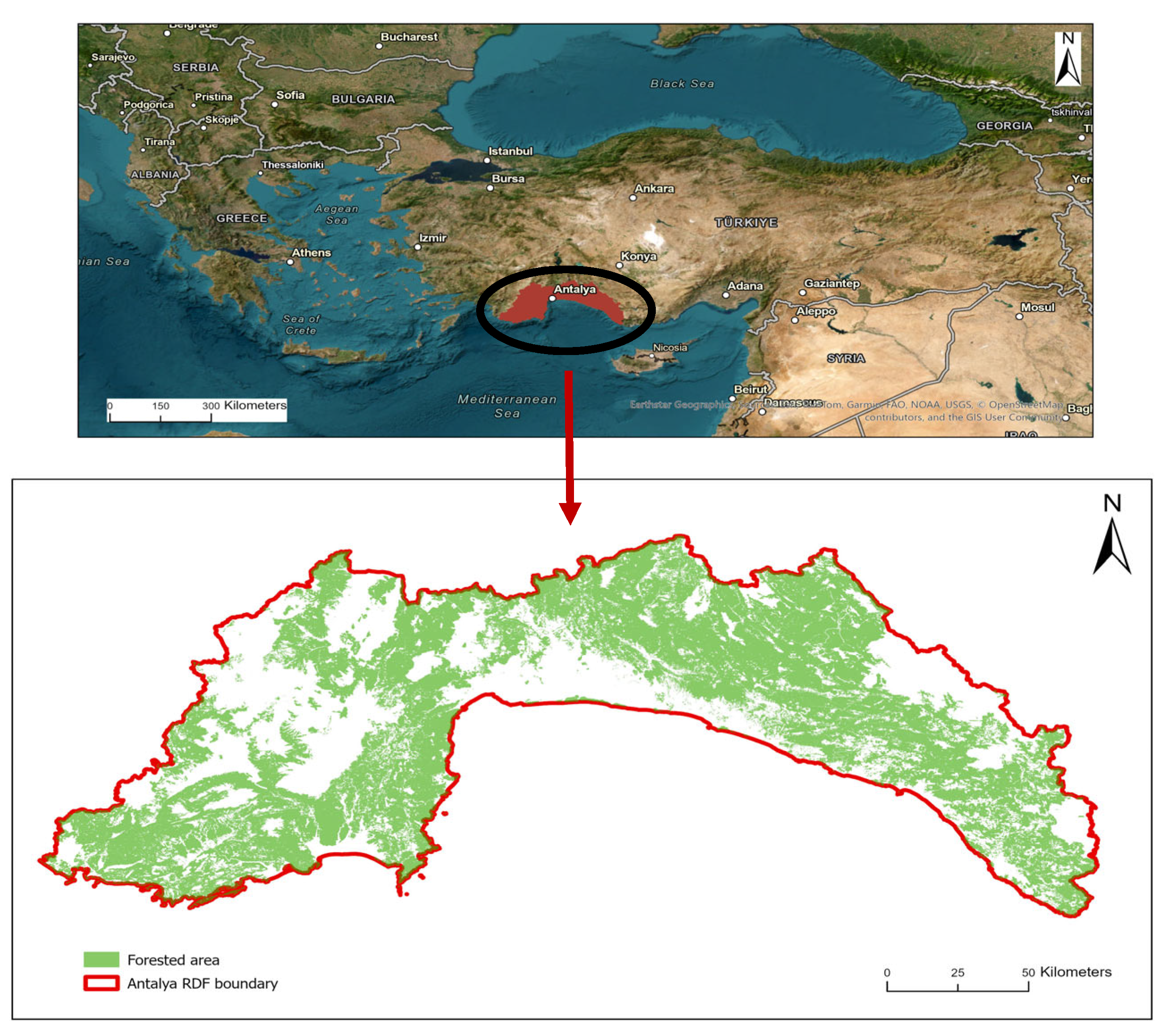
Figure 1. The location of Antalya RDF and forested areas.
Forests 16 01755 g001
Figure 2. Flowchart of the methodology.
Forests 16 01755 g002
Figure 3. Additional accessible forest areas with high probability of fire for improved roads.
Forests 16 01755 g003
Figure 4. Total area reached by improved roads and forest roads network.
Forests 16 01755 g004
Table 1. Fuzzy-AHP parameters and weights of fire influencing factors.
Main CriteriaSub-CriteriaMembership FunctionNormalized WeightDescription/Influence on Fire Probability
Stand characteristicsTree speciesLarge0.2835Coniferous species are more flammable due to higher resin and lower moisture content.
Canopy closureLarge0.0995Dense canopy increases surface fuel accumulation and continuity.
Stand ageSmall0.2075Younger stands are more vulnerable to fire due to thinner bark and smaller diameters.
Topographic factorsSlopeLarge0.0562Fire spreads faster on steep slopes.
AspectNear0.0203South-facing slopes are drier and more fire-prone.
Climatic parametersFire Weather Index (FWI)Near0.0326Combined indicator of temperature, humidity, wind, and precipitation influencing fire danger.
Proximity to anthropogenic structuresDistance to roadsLinear0.1827Proximity to roads increases human-related fire ignition.
Distance to settlementsLinear0.0317Increased human activity elevates fire probability.
Distance to agricultural areasLinear0.0859Burning agricultural residues may cause nearby forest fires.
Consistency ratio (CR)0.0372Indicates acceptable consistency (CR < 0.1).
Table 2. Critical response times according to fire sensitivity levels.
Fire Sensitivity Levels
IIIIIIIVV
Critical response times20 min30 min40 min50 min50 min
Table 3. Road improvement construction (major repair) unit costs.
Construction ActivitiesUnitUnit Price (€)
Excavation and use of all types of soil ground with a bulldozerm30.51
Excavation and use of all kinds of hard soil ground with a bulldozerm31.03
Excavation and use of all kinds of soft rock with an excavatorm31.96
Excavation and use of all kinds of hard rock with an excavatorm32.38
Leveling on all soil ground except hard soilkm77.10
Leveling on hard soil groundkm96.38
Leveling on all rocky groundkm154.21
Table 4. Surface construction unit costs.
Construction ActivitiesUnitUnit Price (€)
Road surface irrigation with a water tankton2.83
Compression with a rubber-tired roller (7–8 tons)hour24.11
Subbase and base material supply with unbroken and non-sieved gravel materialm31.89
Material spreading with machinesm30.38
Material loading and unloading with machinem32.04
Material transportation (long distance) m330.06
Table 5. Rotation periods for tree species (years).
Tree SpeciesForests Allocated
to Wood Production
Forests Allocated to Other (Non-Wood)
Purposes Sociocultural Functions
Brutian pine60120
Black pine120150
Cedar120150
Juniper120150
Taurus fir60100
Oak120200
Table 6. Amounts of forest area (ha) that can be saved as a result of road improvement according to tree species and FEDs.
FEDsTree Species *
ÇzÇkSArGMMakDyTotal
Akseki707.301671.981427.772696.754911.1796.77267.99153.1611,932.89
Alanya4584.662169.371347.16147.711508.4066.3043.601.039868.22
Antalya1138.340.000.000.000.0050.91723.5225.511938.28
Elmalı0.050.001665.951588.360.00217.990.000.003472.36
Finike59.970.00272.3145.200.0019.640.000.00397.13
Gazipaşa2832.69375.61415.979.14263.57463.52144.964.454509.92
Gündoğmuş40.4254.61124.23561.82151.7343.330.000.00976.14
Kaş3271.67256.843999.81107.540.003286.210.00205.6711,127.75
Konyaaltı3005.272.7681.1478.960.0049.681116.2510.344344.40
Korkuteli1607.47715.59896.044442.560.001269.940.000.008931.60
Kumluca2844.632.78303.510.000.00307.720.002.603461.25
Manavgat8678.68468.390.00866.03383.6619.340.001148.3611,564.46
Serik2498.9130.4710.4590.950.000.000.0049.532680.31
Taşağıl4272.271420.1650.84654.160.36121.210.00143.836662.82
Total35,542.347168.5510,595.1811,289.207218.886012.562296.331744.4981,867.53
* Çz: Brutian pine, Çk: Black pine, S: Cedar, Ar: Juniper, G: Taurus fir, M: Oak, Mak: Maquis, and Dy: Other deciduous.
Table 7. Amounts of forest products (m3) that can be saved as a result of road improvement according to tree species and FEDs.
FEDsTree Species *
ÇzÇkSArGMTotal
Akseki5101.7689,840.397668.27−3259.9241,941.70−588.41140,703.79
Alanya60,937.80−38,336.68−13,732.57−0.74324.89−540.928651.78
Antalya41,479.220.000.000.000.004898.1046,377.32
Elmalı1.860.0032,735.32−215.950.00−25.8332,495.40
Finike790.820.00−825.31−30.250.000.00−64.74
Gazipaşa70,801.53−3744.18−2011.080.004473.61−18,498.3251,021.56
Gündoğmuş0.165.69−852.68−19.006.0038.23−821.60
Kaş186,465.3710,409.05−26,477.76−46.820.00−155.32170,194.52
Konyaaltı−12,785.61271.50742.02−0.250.00−3039.89−14,812.23
Korkuteli42,231.419672.3051,234.80−4654.910.00−0.4698,483.14
Kumluca141,922.800.00216.040.000.0010,083.60152,222.44
Manavgat37,645.941956.700.00−145.740.00578.8640,035.76
Serik81,999.002472.16−11.98−0.740.000.0084,458.44
Taşağıl74,512.1088,181.02−443.13−0.020.000.00162,249.97
Total731,104.16160,727.9548,241.94−8374.3446,746.20−7250.36971,195.55
* Çz: Brutian pine, Çk: Black pine, S: Cedar, Ar: Juniper, G: Taurus fir, M: Oak.
Table 8. Economic values of forest products (€) that can be saved as a result of road improvement according to tree species and FEds, according to market prices in 2024.
FEDsTree Species *
ÇzÇkSArGMTotal
Akseki153,1964,489,950364,154−236,4472,274,486−61,8616,983,479
Alanya536,381−3,495,315−1,438,837−5533,303−29,995−4,394,518
Antalya1,930,9720000285,1632,216,135
Elmalı6701,573,949−16,0460−21061,555,863
Finike43,6440−98,421−225100−57,027
Gazipaşa2,507,014−637,882−181,6690246,395−1,666,370267,488
Gündoğmuş4−5098−72,296−13963312233−76,224
Kaş9,658,889720,734−3,314,249−35310−12,3917,049,452
Konyaaltı−1,761,20021,91925,180−190−196,730−1,910,849
Korkuteli1,335,238266,3352,821,888−381,7160−274,041,718
Kumluca9,277,1660−543200588,0479,859,781
Manavgat169,352−117,1860−10,875033,80875,099
Serik4,236,980198,675−1191−55004,434,410
Taşağıl3,147,6764,543,801−46,980−2007,644,496
Total31,235,3805,985,931−373,903−652,3922,554,515−1,060,22937,689,301
* Çz: Brutian pine, Çk: Black pine, S: Cedar, Ar: Juniper, G: Taurus fir, and M: Oak.
Disclaimer/Publisher’s Note: The statements, opinions and data contained in all publications are solely those of the individual author(s) and contributor(s) and not of MDPI and/or the editor(s). MDPI and/or the editor(s) disclaim responsibility for any injury to people or property resulting from any ideas, methods, instructions or products referred to in the content.