Modeling the Geometry of Tree Trunks Using LiDAR Data




Abstract
1. Introduction
- Highly accurate trunk modeling approach, which can be easily visualized and integrated within 3D scenes regarding its light memory requirement.
- The suggested approach aims to model general tree species and geometrical forms without restriction on certain tree species and geometry.
- Automatic discrimination between the point clouds of tree crown and trunk, which helps to model and analyze them separately.
- Calculation and analysis of the tree trunk geometric shapes.
2. Datasets
3. Trunk Geometry Analysis
3.1. Distinguishability of Trunk Point Cloud
3.2. Trunk Geometry
4. Methodology
4.1. Extraction of Trunk Point Cloud
4.2. Segmentation of Tree Trunk into Single Stems
4.3. Modeling of Single Stems
5. Results and Discussion
6. Conclusions
Author Contributions
Funding
Data Availability Statement
Acknowledgments
Conflicts of Interest
References
- Tao, F.; Xiao, B.; Qi, Q.; Cheng, J.; Ji, P. Digital twin modeling. J. Manuf. Syst. 2022, 64, 372–389. [Google Scholar] [CrossRef] [Scilit]
- Hakimi, O.; Liu, H.; Abudayyeh, O.; Houshyar, A.; Almatared, M.; Alhawiti, A. Data Fusion for Smart Civil Infrastructure Management: A Conceptual Digital Twin Framework. Buildings 2023, 13, 2725. [Google Scholar] [CrossRef] [Scilit]
- Ahmad, A.M.; Aliyu, A.A. The need for landscape information modelling (LIM) in landscape architecture. In Proceedings of the 13th Digital Landscape Architecture Conference, Weimar, Germany, 31 May–2 June 2012; Volume 40. [Google Scholar]
- Song, J.; Park, S.; Lee, K.; Bae, J.; Kwon, S.; Cho, C.-S.; Chung, S. Augmented Reality-Based BIM Data Compatibility Verification Method for FAB Digital Twin implementation. Buildings 2023, 13, 2683. [Google Scholar] [CrossRef] [Scilit]
- Mylo, M.D.; Ludwig, F.; Rahman, M.A.; Shu, Q.; Fleckenstein, C.; Speck, T.; Speck, O. Conjoining Trees for the Provision of Living Architecture in Future Cities: A Long-Term Inosculation Study. Plants 2023, 12, 1385. [Google Scholar] [CrossRef] [Scilit]
- Austin, M.; Delgoshaei, P.; Coelho, M.; Heidarinejad, M. Architecting smart city digital twins: Combined semantic model and machine learning approach. J. Manag. Eng. 2020, 36, 04020026. [Google Scholar] [CrossRef] [Scilit]
- Souza, L.; Bueno, C. City Information Modelling as a support decision tool for planning and management of cities: A systematic literature review and bibliometric analysis. Build. Environ. 2022, 207, 108403. [Google Scholar] [CrossRef] [Scilit]
- Qiu, H.; Zhang, H.; Lei, K.; Zhang, H.; Hu, X. Forest digital twin: A new tool for forest management practices based on Spatio-Temporal Data, 3D simulation Engine, and intelligent interactive environment. Comput. Electron. Agric. 2023, 215, 108416. [Google Scholar] [CrossRef] [Scilit]
- Veglianti, E.; Magnaghi, E.; De Marco, M.; Li, Y. Smart city in China: The state of art of Xiong a new area. In Organizing Smart Buildings and Cities; Springer: Cham, Switzerland, 2021; Volume 39, pp. 81–97. [Google Scholar] [CrossRef] [Scilit]
- Jeddoub, I.; Nys, G.A.; Hajji, R.; Billen, R. Digital Twins for cities: Analyzing the gap between concepts and current implementations with a specific focus on data integration. Int. J. Appl. Earth Obs. Geoinf. 2023, 122, 103440. [Google Scholar] [CrossRef] [Scilit]
- Richa, J.P.; Deschaud, J.-E.; Goulette, F.; Dalmasso, N. AdaSplats: Adaptive Splatting of Point Clouds for Accurate 3D Modeling and Real-Time High-Fidelity LiDAR Simulation. Remote Sens. 2022, 14, 6262. [Google Scholar] [CrossRef] [Scilit]
- Wang, Y.; Du, W.; Wang, H.; Zhao, Y. Intelligent Generation Method of Innovative Structures Based on Topology Optimization and Deep Learning. Materials 2021, 14, 7680. [Google Scholar] [CrossRef] [Scilit] [PubMed]
- Tarsha Kurdi, F.; Amakhchan, W.; Gharineiat, Z.; Boulaassal, H.; El Kharki, O. Contribution of geometric feature analysis for deep learning classification algorithms of urban LiDAR data. Sensors 2023, 23, 7360. [Google Scholar] [CrossRef] [Scilit]
- Tarsha Kurdi, F.; Gharineiat, Z.; Campbell, G.; Awrangjeb, M.; Dey, E.K. Automatic Filtering of Lidar Building Point Cloud in Case of Trees Associated to Building Roof. Remote Sens. 2022, 14, 430. [Google Scholar] [CrossRef] [Scilit]
- Tarsha Kurdi, F.; Reed, P.; Gharineiat, Z.; Awrangjeb, M. Efficiency of terrestrial laser scanning in survey works: Assessment, modelling, and monitoring. Int. J. Environ. Sci. Nat. Resour. 2023, 28, 556234. [Google Scholar] [CrossRef] [Scilit]
- McTegg, S.J.; Tarsha Kurdi, F.; Simmons, S.; Gharineiat, Z. Comparative approach of unmanned aerial vehicle restrictions in controlled airspaces. Remote Sens. 2022, 14, 822. [Google Scholar] [CrossRef] [Scilit]
- Jayaraj, P.; Ramiya, A.M. 3D CITYGML building modelling from LIDAR point cloud data. Int. Arch. Photogramm. Remote Sens. Spat. Inf. Sci. 2018, 42, 175–180. [Google Scholar] [CrossRef] [Scilit]
- Schwab, B.; Beil, C.; Kolbe, T.H. Spatio-Semantic Road Space Modeling for Vehicle–Pedestrian Simulation to Test Automated Driving Systems. Sustainability 2020, 12, 3799. [Google Scholar] [CrossRef] [Scilit]
- Nikoohemat, S.; Peter, M.; Oude Elberink, S.; Vosselman, G. Semantic Interpretation of Mobile Laser Scanner Point Clouds in Indoor Scenes Using Trajectories. Remote Sens. 2018, 10, 1754. [Google Scholar] [CrossRef] [Scilit]
- Zhang, Z.; Qian, Z.; Zhong, T.; Chen, M.; Zhang, K.; Yang, Y.; Zhu, R.; Zhang, F.; Zhang, H.; Zhou, F.; et al. Vectorized rooftop area data for 90 cities in China. Sci. Data 2022, 9, 66. [Google Scholar] [CrossRef] [Scilit] [PubMed]
- Peters, R.; Dukai, B.; Vitalis, S.; van Liempt, J.; Stoter, J. Automated 3D Reconstruction of LoD2 and LoD1 Models for All 10 million Buildings of the Netherlands. Photogramm. Eng. Remote Sens. 2022, 88, 165–170. [Google Scholar] [CrossRef] [Scilit]
- Milojevic-Dupont, N.; Wagner, F.; Nachtigall, F.; Hu, J.; Brüser, G.B.; Zumwald, M.; Biljecki, F.; Heeren, N.; Kaack, L.H.; Pichler, P.P.; et al. EUBUCCO v0.1: European building stock characteristics in a common and open database for 200+ million individual buildings. Sci. Data 2023, 10, 147. [Google Scholar] [CrossRef] [Scilit]
- Zorzi, S.; Bittner, K.; Fraundorfer, F. Machine-learned regularization and polygonization of building segmentation masks. In Proceedings of the 2020 25th International Conference on Pattern Recognition (ICPR), 3098–3105, Milan, Italy, 10–15 January 2021. [Google Scholar] [CrossRef] [Scilit]
- Liu, Z.; Tang, H.; Feng, L.; Lyu, S. CBRA: The first multi-annual (2016–2021) and high-resolution (2.5 m) building rooftop area dataset in China derived with Super-resolution Segmentation from Sentinel-2 imagery. Earth Syst. Sci. 2023, 15, 3547–3572. [Google Scholar] [CrossRef] [Scilit]
- Wysocki, O.; Xia, Y.; Wysocki, M.; Grilli, E.; Hoegner, L.; Cremers, D.; Stilla, U. Scan2LoD3: Reconstructing semantic 3D building models at LoD3 using ray casting and Bayesian networks. In Proceedings of the IEEE/CVF Conference on Computer Vision and Pattern Recognition (CVPR) Workshops 2023, Vancouver, BC, Canada, 17–24 June 2023. [Google Scholar] [CrossRef] [Scilit]
- Wen, X.; Xie, H.; Liu, H.; Yan, L. Accurate Reconstruction of the LoD3 Building Model by Integrating Multi-Source Point Clouds and Oblique Remote Sensing Imagery. ISPRS Int. J. Geo-Inf. 2019, 8, 135. [Google Scholar] [CrossRef] [Scilit]
- Tarsha Kurdi, F.; Awrangjeb, M. Comparison of LiDAR Building Point Cloud with Reference Model for Deep Comprehension of Cloud Structure. Can. J. Remote Sens. 2020, 46, 603–621. [Google Scholar] [CrossRef] [Scilit]
- Pantoja-Rosero, B.G.; Achanta, R.; Kozinski, M.; Fua, P.; Perez-Cruz, F.; Beyer, K. Generating LOD3 building models from structure-from-motion and semantic segmentation. Autom. Constr. 2022, 141, 9. [Google Scholar] [CrossRef] [Scilit]
- Lewandowicz, E.; Tarsha Kurdi, F.; Gharineiat, Z. 3D LoD2 and LoD3 Modeling of Buildings with Ornamental Towers and Turrets Based on LiDAR Data. Remote Sens. 2022, 14, 4687. [Google Scholar] [CrossRef] [Scilit]
- Tarsha Kurdi, F.; Lewandowicz, E.; Gharineiat, Z.; Shan, J. Modeling Multi-Rotunda Buildings at LoD3 Level from LiDAR Data. Remote Sens. 2023, 15, 3324. [Google Scholar] [CrossRef] [Scilit]
- Choi, I.-H.; Nam, S.-K.; Kim, S.-Y.; Lee, D.-G. Forest Digital Twin Implementation Study for 3D Forest Geospatial Information Service. Korean, J. Remote Sens. 2023, 39, 1165–1172. [Google Scholar] [CrossRef]
- Wei, Z.; Li, X.; He, Z. Semantic Urban Vegetation Modelling Based on an Extended CityGML Description. J. Digit. Landsc. Archit. 2022, 7, 200–212. [Google Scholar] [CrossRef]
- Ortega-Códrowa, M. Urban Vegetation Modeling 3D Levels of Detail. Master’ Thesis, Delft University of Technology, Delft, The Netherlands, 2018. Available online: https://repository.tudelft.nl/islandora/object/uuid%3A8b8967a8-0a0f-498f-9d37-71c6c3e532af (accessed on 15 October 2023).
- Chen, Z.; Xu, B.; Devereux, B. Urban landscape pattern analysis base on 3D landscape models. Appl. Geogr. 2014, 55, 82–91. [Google Scholar] [CrossRef] [Scilit]
- Liang, X.; Kankare, V.; Hyyppa, J.; Wang, Y.; Kuuo, A.; Vastaranta, M. Terresial laser scanning in forest inventories. ISPRS J. Photoigrmetry Remonte Sens. 2016, 115, 63–67. [Google Scholar] [CrossRef] [Scilit]
- Lombard, L.; Ismail, R.; Poona, N.K. Modelling forest species using Lidar-derived metrics of forest canopy gaps. South Afr. J. Geomat. 2022, 9, 31–43. [Google Scholar] [CrossRef] [Scilit]
- Hyyppä, J.; Hyyppä, H.; Leckie, D.; Gougeon, F.; Yu, X.; Maltamo, M. Review of methods of small-footprint airborne laser scanning for extracting forest inventory data in boreal forests. Int. J. Remote Sens. 2008, 29, 1339–1366. [Google Scholar] [CrossRef] [Scilit]
- Zhen, Z.; Quackenbush, L.J.; Zhang, L. Trends in Automatic Individual Tree Crown Detection and Delineation—Evolution of LiDAR Data. Remote Sens. 2016, 8, 333. [Google Scholar] [CrossRef] [Scilit]
- Zhang, B.; Li, X.; Du, H.; Zhou, G.; Mao, F.; Huang, Z.; Zhou, L.; Xuan, J.; Gong, Y.; Chen, C. Estimation of Urban Forest Characteristic Parameters Using UAV-Lidar Coupled with Canopy Volume. Remote Sens. 2022, 14, 6375. [Google Scholar] [CrossRef] [Scilit]
- Yang, B.; Dai, W.; Dong, Z.; Liu, Y. Automatic Forest Mapping at Individual Tree Levels from Terrestrial Laser Scanning Point Clouds with a Hierarchical Minimum Cut Method. Remote Sens. 2016, 8, 372. [Google Scholar] [CrossRef] [Scilit]
- Heinzel, J.; Huber, M.O. Detecting Tree Stems from Volumetric TLS Data in Forest Environments with Rich Understory. Remote Sens. 2017, 9, 9. [Google Scholar] [CrossRef] [Scilit]
- Weinmann, M.; Weinmann, M.; Mallet, C.; Brédif, M. A Classification-Segmentation Framework for the Detection of Individual Trees in Dense MMS Point Cloud Data Acquired in Urban Areas. Remote Sens. 2017, 9, 277. [Google Scholar] [CrossRef] [Scilit]
- Heinzel, J.; Huber, M.O. Constrained Spectral Clustering of Individual Trees in Dense Forest Using Terrestrial Laser Scanning Data. Remote Sens. 2018, 10, 1056. [Google Scholar] [CrossRef] [Scilit]
- Xu, N.; Ye, N.; Xu, S.; Zhu, F. A supervoxel approach to the segmentation of individual trees from LiDAR point clouds. Remote Sens. Lett. 2018, 9, 515–523. [Google Scholar] [CrossRef] [Scilit]
- Bian, Y.; Zou, P.; Shu, Y.; Yu, R. Individual tree delineation in deciduous forest areas with LiDAR point clouds. Can. J. Remote Sens. 2014, 40, 152–163. [Google Scholar] [CrossRef] [Scilit]
- Michałowska, M.; Rapiński, J. A Review of Tree Species Classification Based on Airborne LiDAR Data and Applied Classifiers. Remote Sens. 2021, 13, 353. [Google Scholar] [CrossRef] [Scilit]
- Tarsha Kurdi, F.W.; Amakhchan, W.; Gharineiat, Z. Random Forest Machine Learning Technique for Automatic Vegetation Detection and Modelling in LiDAR Data. Int. J. Environ. Sci. Nat. Resour. 2021, 28, 556234. [Google Scholar] [CrossRef] [Scilit]
- Adhikari, A.; Montes, C.R.; Peduzzi, A. A Comparison of Modeling Methods for Predicting Forest Attributes Using Lidar Metrics. Remote Sens. 2023, 15, 1284. [Google Scholar] [CrossRef] [Scilit]
- Putra, J.C.; Arie Wahyu Wijayanto, A.W. Automatic detection and counting of oil palm trees using remote sensing and object-based deep learning. Remote Sens. Appl. Soc. Environ. 2023, 2, 100914. [Google Scholar] [CrossRef] [Scilit]
- Lei, J.; Li, H.; Zhao, S.; Wang, Y.; Jiang, Y.; Zhu, G. Automatic Identification of Street Trees with Improved RandLA-Net and Accurate Calculation of Shading Area with Density-Based Iterative α-Shape. IEEE Access 2022, 10, 132384–132395. [Google Scholar] [CrossRef] [Scilit]
- Silva, C.A.; Hudak, A.T.; Vierling, L.A.; Loudermilk, E.L.; O’Brien, J.J.; Hiers, J.K.; Jack, S.B.; Gonzalez-Benecke, C.; Lee, H.; Falkowski, M.J. Imputation of individual longleaf pine (Pinus palustris Mill.) tree attributes from field and LiDAR data. Can. J. Remote Sens. 2016, 42, 554–5730. [Google Scholar] [CrossRef] [Scilit]
- Yu, X.; Hyyppä, J.; Litkey, P.; Kaartinen, H.; Vastaranta, M.; Holopainen, M. Single-Sensor Solution to Tree Species Classification Using Multispectral Airborne Laser Scanning. Remote Sens. 2017, 9, 108. [Google Scholar] [CrossRef] [Scilit]
- Cabo, C.; Del Pozo, S.; Rodríguez-Gonzálvez, P.; Ordóñez, C.; González-Aguilera, D. Comparing Terrestrial Laser Scanning (TLS) and Wearable Laser Scanning (WLS) for Individual Tree Modeling at Plot Level. Remote Sens. 2018, 10, 540. [Google Scholar] [CrossRef] [Scilit]
- Koch, B.; Heyder, U.; Weinacker, H. Detection of individual tree crowns in airborne lidar data. Photogramm. Eng. Remote Sens. 2006, 72, 357–363. [Google Scholar] [CrossRef] [Scilit]
- Kwak, D.-A.; Lee, W.-K.; Lee, J.-H.; Biging, G.S.; Gong, P. Detection of individual trees and estimation of tree height using LiDAR data. J. For. Res. 2007, 12, 425–434. [Google Scholar] [CrossRef] [Scilit]
- Marić, B.; Bećirović, D.Ž.; Brajić, A.; Delić, S.; Pezdevšek Malovrh, Š.; Avdibegović, M. Pan-European Criteria for Sustainable Forest Management—Attitudes of Forestry Professionals in the Federation of Bosnia and Herzegovina. S.-E. Eur. For. 2023, 14, 1–14. [Google Scholar] [CrossRef] [Scilit]
- Konstantinavičienė, J. Assessment of Potential of Forest Wood Biomass in Terms of Sustainable Development. Sustainability 2023, 15, 13871. [Google Scholar] [CrossRef] [Scilit]
- Peng, C.; Liu, J.; Dang, Q.; Apps, M.J.; Jiang, H. TRIPLEX: A generic hybrid model for predicting forest growth and carbon and nitrogen dynamics. Ecol. Model. 2002, 153, 109–130. [Google Scholar] [CrossRef] [Scilit]
- Morales, M.M.; Tonini, H.; Behling, M.; Hoshide, A.K. Eucalyptus Carbon Stock Research in an Integrated Livestock-Forestry System in Brazil. Sustainability 2023, 15, 7750. [Google Scholar] [CrossRef] [Scilit]
- Hirata, Y.; Furuya, N.; Suzuki, M.; Yamamoto, H. Airborne laser scanning in forest management: Individual tree identification and laser pulse penetration in a stand with different levels of thinning. For. Ecol. Manag. 2009, 258, 752–760. [Google Scholar] [CrossRef] [Scilit]
- Béland, M.; Widlowski, J.L.; Fournier, R.A.; Côté, J.F.; Verstraete, M.M. Estimating leaf area distribution in savanna trees from terrestrial LiDAR measurements. Agric. For. Meteorol. 2011, 151, 1252–1266. [Google Scholar] [CrossRef] [Scilit]
- Yan, Z.; Liu, R.; Cheng, L.; Zhou, X.; Ruan, X.; Xiao, Y. A Concave Hull Methodology for Calculating the Crown Volume of Individual Trees Based on Vehicle-Borne LiDAR Data. Remote Sens. 2019, 11, 623. [Google Scholar] [CrossRef] [Scilit]
- Dai, M.; Li, G. Soft Segmentation and Reconstruction of Tree Crown from Laser Scanning Data. Electronics 2023, 12, 2300. [Google Scholar] [CrossRef] [Scilit]
- Tockner, A.; Gollob, C.; Kraßnitze, R.; Ritte, T.; Nothdurft, A. Automatic tree crown segmentation using dense forest point clouds from Personal Laser Scanning (PLS). Int. J. Appl. Earth Obs. Geoinf. 2022, 114, 103025. [Google Scholar] [CrossRef] [Scilit]
- Treemap. Available online: https://www.mapadrzew.com/ (accessed on 15 October 2023).
- Tarsha Kurdi, F.; Lewandowicz, E.; Shan, J.; Gharineiat, Z. 3D modeling and visualization of single tree Lidar point cloud using matrixial form. IEEE J. Sel. Top. Appl. Earth Obs. Remote Sens. 2024, 17, 3010–3022. [Google Scholar] [CrossRef] [Scilit]
- Godin, C. Representing and encoding plant architecture: A review. Ann. For. Sci. 2000, 57, 413–438. Available online: https://www.afs-journal.org/articles/forest/pdf/2000/05/f0502.pdf (accessed on 15 October 2023). [CrossRef] [Scilit]
- Bucksch, A.; Lindenbergh, R.; Menenti, M. SkelTre: Robust skeleton extraction from imperfect point clouds. Vis. Comput. Int. J. Comput. Graph. 2010, 26, 283–1300. [Google Scholar] [CrossRef] [Scilit]
- Xu, J.; Shan, J.; Wang, G. Hierarchical Modeling of Street Trees Using Mobile Laser Scanning. Remote Sens. 2020, 12, 2321. [Google Scholar] [CrossRef] [Scilit]
- Huang, Z.; Huang, X.; Fan, J.; Eichhorn, M.P.; An, F.; Chen, B.; Cao, L.; Zhu, Z.; Yun, T. Retrieval of Aerodynamic Parameters in Rubber Tree Forests Based on the Computer Simulation Technique and Terrestrial Laser Scanning Data. Remote Sens. 2020, 12, 1318. [Google Scholar] [CrossRef] [Scilit]
- Azaïs, R.; Habibeche, S.; Ben-Naoum, B.; Godin, C. Exploring symmetries in plant architectures. In Proceedings of the 10th International Conference on Functional-Structural Plant Models: FSPM 2023, Berlin, Germany, 27–30 March 2023; Available online: https://www.researchgate.net/publication/373013986_Exploring_symmetries_in_plant_architectures (accessed on 15 October 2023).
- Godin, C.; Ferraro, P. Quantifying the Degree of Self-Nestedness of Trees: Application to the Structural Analysis of Plants. IEEE/ACM Trans. Comput. Biol. Bioinform. 2010, 7, 688–703. [Google Scholar] [CrossRef] [Scilit] [PubMed]
- Longman Dictionary of Contemporary English Online. Available online: https://www.ldoceonline.com/ (accessed on 15 October 2023).
- Dey, E.K.; Tarsha Kurdi, F.; Awrangjeb, M.; Stantic, B. Effective selection of variable point neighbourhood for feature point extraction from aerial building point cloud data. Remote Sens. 2021, 13, 1520. [Google Scholar] [CrossRef] [Scilit]
- Tarsha Kurdi, F.; Landes, T.; Grussenmeyer, P. Hough-transform and extended RANSAC algorithms for automatic detection of 3D building roof planes from Lidar data. In Proceedings of the ISPRS Workshop on Laser Scanning 2007 and SilviLaser 2007, Espoo, Finland, 12–14 September 2007; pp. 407–412. [Google Scholar]
- Tarsha Kurdi, F.; Landes, T.; Grussenmeyer, P. Extended RANSAC algorithm for automatic detection of building roof planes from Lidar data. Photogramm. J. Finl. 2008, 21, 97–109. [Google Scholar]
- Ostrowski, W.; Pilarska, M.; Charyton, J.; Bakuła, K. Analysis of 3D building models accuracy based on the airborne Laser scanning point clouds. Int. Arch. Photogramm. Remote Sens. Spat. Inf. Sci. 2018, 42, 797–804. [Google Scholar] [CrossRef] [Scilit]
- Cheng, L.; Zhang, W.; Zhong, L.; Du, P.; Li, M. Framework for evaluating visual and geometric quality of three-dimensional models. IEEE J. Sel. Top. Appl. Earth Obs. Remote Sens. 2015, 8, 1281–1294. [Google Scholar] [CrossRef] [Scilit]


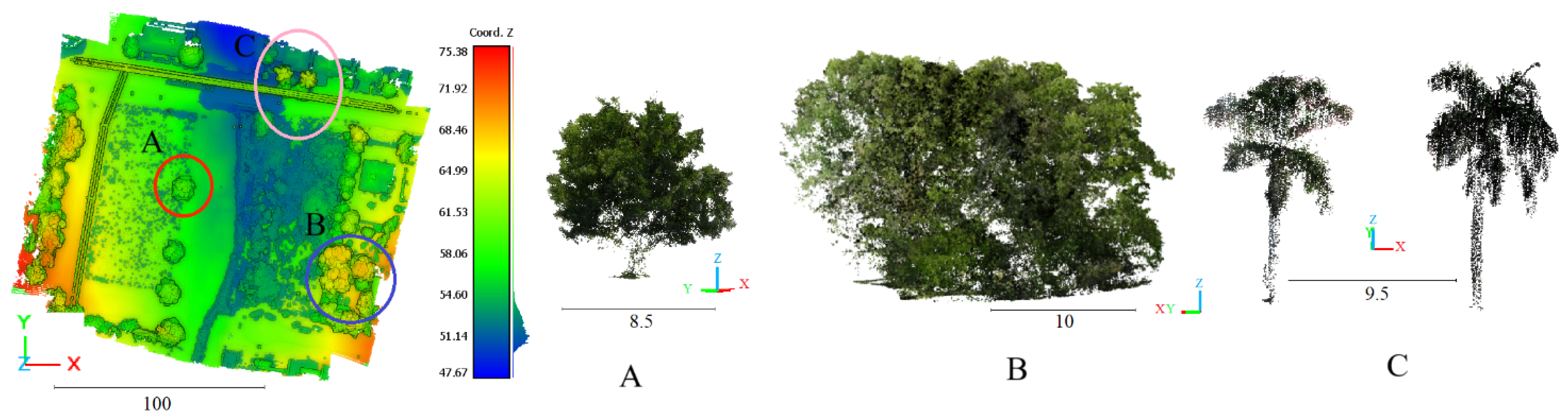





| Z+F IMAGER 5016 | TrueView 515 | |
|---|---|---|
| Platform | Ground | UAV |
| Field of view | 360° × 320° | 120° |
| Max measurement rate | 1 Mio. points/s | - |
| Max range | 360 m | 80 m |
| Laser class | 1 “eye-safe” | - |
| HDR camera | Full panorama (80 MPixel) | Cameras, 2x 20 MP, RGB Dual 1″ mechanical shutter |
| Spot diameter | ~3.5 mm @ 1 m/~0.3 mrad | - |
Disclaimer/Publisher’s Note: The statements, opinions and data contained in all publications are solely those of the individual author(s) and contributor(s) and not of MDPI and/or the editor(s). MDPI and/or the editor(s) disclaim responsibility for any injury to people or property resulting from any ideas, methods, instructions or products referred to in the content. |
© 2024 by the authors. Licensee MDPI, Basel, Switzerland. This article is an open access article distributed under the terms and conditions of the Creative Commons Attribution (CC BY) license (https://creativecommons.org/licenses/by/4.0/).
Share and Cite
Tarsha Kurdi, F.; Gharineiat, Z.; Lewandowicz, E.; Shan, J. Modeling the Geometry of Tree Trunks Using LiDAR Data. Forests 2024, 15, 368. https://doi.org/10.3390/f15020368
Tarsha Kurdi F, Gharineiat Z, Lewandowicz E, Shan J. Modeling the Geometry of Tree Trunks Using LiDAR Data. Forests. 2024; 15(2):368. https://doi.org/10.3390/f15020368
Chicago/Turabian StyleTarsha Kurdi, Fayez, Zahra Gharineiat, Elżbieta Lewandowicz, and Jie Shan. 2024. "Modeling the Geometry of Tree Trunks Using LiDAR Data" Forests 15, no. 2: 368. https://doi.org/10.3390/f15020368
APA StyleTarsha Kurdi, F., Gharineiat, Z., Lewandowicz, E., & Shan, J. (2024). Modeling the Geometry of Tree Trunks Using LiDAR Data. Forests, 15(2), 368. https://doi.org/10.3390/f15020368