Article

A Digital Management System for Monitoring Epidemics and the Management of Pine Wilt Disease in East China

1
College of Forestry and Biotechnology, Zhejiang A&F University, Hangzhou 311300, China
2
China Bamboo National Research Center, Hangzhou 310012, China
3
Zhejiang Provincial Forest Disease and Pest Control Station, Hangzhou 310019, China
*
Authors to whom correspondence should be addressed.
Forests 2024, 15(12), 2174; https://doi.org/10.3390/f15122174
Submission received: 31 October 2024 / Revised: 2 December 2024 / Accepted: 3 December 2024 / Published: 10 December 2024
(This article belongs to the Special Issue Advance in Pine Wilt Disease)

Abstract

:
The precise monitoring of forest pest and disease outbreaks is a crucial prerequisite for efficient prevention and control. With the extensive application of remote sensing monitoring technology in the forest, a large amount of data on pest and disease outbreaks has been collected. It is highly necessary to practically apply these data and improve the efficiency of forest pest and disease monitoring and management. In this study, a Digital Forest Protection (DFP) system based on the geographic information system (GIS) was designed and developed for pine wilt disease (PWD) monitoring and management, a devastating forest disease caused by the pine wood nematode, Bursaphelenchus xylophilus. The DFP system consists of a mobile app for data collection and a web-based data analysis platform. Meanwhile, artificial intelligence and deep-learning methods had been conducted to integrate a real-time unmanned aerial vehicle (UAV) remote sensing monitoring with PWD detection. This system was implemented in PWD monitoring and management in Zhejiang Province, China, and has been applied in data collection under certain circumstances, including the manual epidemic survey, the UAV epidemic survey, and eradication monitoring, as well as trunk injection. Based on DFP system, the effective monitoring of PWD outbreaks could be achieved, and corresponding efficient management strategies could be formulated in a timely manner. This allows for the possibility to optimize the integrated management strategy of PWD on a large geographic scale.

Graphical Abstract

1. Introduction

Pine wilt disease (PWD), caused by the invasive nematode pinewood nematode (PWN) Bursaphelenchus xylophilus, is currently recognized as one of the most dangerous, rapidly spreading, and devastating forest diseases affecting global forest ecosystems [1,2,3]. It is also considered to be one of the most severe biological threats to the biological safety of forests in China [4,5]. In 2021, PWD outbreaks were reported in 742 county-level administrative regions across 19 provinces in China, impacting an area of 1.72 million ha and resulting in the mortality of over 10 million pine trees, thereby posing a significant threat to national ecological security and forest resource security [6]. The PWD epidemic is spread in forests by the pine sawyer beetle and can also be transmitted over long distances by human beings [5,7,8]. Precise location and accurate monitoring are urgently needed to establish effective management of PWD epidemics.
The monitoring of PWD epidemics, due to the insect vector, primarily Monochamus spp., presents a significant challenge worldwide [9,10,11,12]. Unlike farmland, forest monitoring encounters more open and complex circumstances, such as inaccessible mountainous and remote areas, which are limited in scope and require substantial time and effort [13]. Recently, advanced methods have been developed to monitor the occurrence of PWD [14,15]. Remote sensing technologies, including airborne spectral imagery [16], remote wireless sensing [17], unmanned aerial vehicle (UAV)-based imagery sensors [18,19,20,21], and high-resolution satellite images [22], have been developed and employed for PWD detection. These advanced monitoring technologies have provided detailed information about diseased trees and their precise location, thereby facilitating accurate and highly efficient monitoring of PWD epidemics [23,24].
The precise location of PWD-infected trees and real-time monitoring on a larger geographical scale also rely on the application of a highly efficient data collection system and high-throughput processing of large datasets [25,26,27]. Recently, deep-learning methodologies utilizing big data have shown high efficiency in the identification and location of PWD-infected pine trees using geographic information systems (GIS) [18,28,29]. The application of these monitoring technologies and deep-learning methods facilitates the precise location of PWN-infected trees, thereby making it possible to precisely monitor pine wood nematode disease outbreaks across at a large geographical scale [4,10].
Despite extensive research on individual PWD monitoring technologies, these technologies have not been widely implemented in practical monitoring and management [4,30]. The primary limiting factor is the absence of a comprehensive data collection and analysis system. Furthermore, there is a paucity of literature on the development of PWD monitoring systems. To address this gap, we developed an integrated multi-functional data collection and analysis system for monitoring PWD epidemics in this study, which we designated Digital Forest Protection (DFP). This system incorporates multiple data-collection technologies, including UAV-based remote sensing and GIS approaches. By integrating these diverse data sources, the system provides a comprehensive view of PWD’s spread and severity across various spatial and temporal scales. Additionally, the system utilizes advanced data analysis techniques, such as machine learning algorithms, to process and interpret collected information, enabling time detection and more precise management measures.

2. Materials and Methods

2.1. The Study Area

The study area, Zhejiang Province, is situated in the southeastern region of China and constitutes the southern wing of the Yangtze River Delta. Geographically, Zhejiang Province extends from 27°02′ N to 31°11′ N and 118°01′ E to 123°10′ E with its eastern border defined by the East China Sea. Located within the subtropical zone, Zhejiang experiences a monsoon-influenced, humid climate. The province encompasses a total forestland area of 6.6797 million ha, of which 5.8442 million ha are forested, resulting in a forest coverage rate of 60.5%. PWD was initially identified in the Xiangshan District of Zhejiang in 1991, leading to substantial mortality among pine trees [31].

2.2. The Data Collection

2.2.1. Manual Survey

Trained field personnel are deployed to sample the pine trees in selected areas. They visually inspect the trees for symptoms such as needle discoloration, wilting, and resin exudation, which are characteristic of PWD.

2.2.2. UAV-Based Survey

UAVs offer a more efficient means of covering larger areas compared to manual surveys. Equipped with high-resolution cameras and sensors, UAVs can capture images of pine forests from above. These images can be used to detect early signs of PWD, such as changes in tree canopy color and density. The UAV-based survey is designed to operate at different altitudes and flight paths to ensure comprehensive coverage. The data collected from UAVs are then processed to extract relevant features related to PWD symptoms.

2.2.3. Satellite Remote Sensing

Satellite remote sensing provides the broadest view of the forest areas at risk of PWD. Satellites equipped with multispectral and hyperspectral sensors can detect large-scale changes in forest cover and vegetation health. The data collected from satellites were used to identify the areas with potential PWD outbreaks based on the spectral signatures associated with stressed or diseased pine trees.

2.3. Data Input into the DFP SYSTEM

After data collection, all the information is inputted into the DFP system. The DFP system is designed with a user-friendly interface to ensure efficient and accurate data entry. For manual survey data, field workers can directly input the information about tree location, symptoms, and laboratory test results into the system using mobile devices or desktop computers.

2.4. Data Processing Within the DFP

Once the data are inputted into the DFP system, they undergo a series of processing steps. For the visual data from manual surveys and UAV-based surveys, image processing algorithms are applied. These algorithms enhance the visibility of the PWD symptoms by adjusting the contrast and color balance, and filtering out noise. For the satellite remote-sensing data, spectral analysis algorithms are employed. These algorithms analyze the spectral signatures of the forest areas to detect anomalies associated with PWD. The processed data from all three sources are then integrated within the DFP system.

2.5. Orleans Distributed Map Service System in DFP System

Each map tile can be represented as a grain in Orleans. The distributed map service system utilizes multicore and multimode parallelism strategies with varying granularity to enhance the spatial parallel computing, data processing, and rendering acceleration performance. The system facilitates layer operations, such as the conversion, superposition, and dynamic display between different coordinates and layers, as well as the data operations, including querying, fusion, cutting, and merging. It provides real-time map tile rendering based on user roles and business rules, enables real-time business data visualization, and supports prediction, early warning, and trend-mining functionalities. This system ensures high reliability and availability through horizontal expansion and rapid service deployment. Data security is maintained through encrypted transmissions. The high-performance requirements in the high-concurrency scenarios were addressed using map-tile caching technology and distributed storage. This system supports cross-platform utilization on the Web and Android, and is compatible with various map service providers. It can provide external map display services while maintaining the localization of private data and offering multidimensional and granular data requests for layers, data, and attributes.

2.6. Establishment of Native Libraries of DFP System

Java and JavaScript were selected to develop a low-level code based on the functional and performance requirements of the system, which directly interacts with the system hardware to facilitate efficient data processing and computation. Subsequently, these low-level codes were compiled into the native libraries (.dll files) for implementation on the Android platform. During the native library creation process, particular emphasis was placed on code optimization and modular design to ensure system stability and scalability. Native libraries that met the system requirements were successfully established, thereby providing a robust foundation for the subsequent development of the system.

2.7. Nacos Dynamic Configuration Service in DFP System

Nacos is utilized as a crucial component in service discovery and configuration management. For the service discovery aspect, each microservice within the system was integrated with the Nacos client. The microservices, which included but were not limited to data access services, business logic services, and API gateway services, were configured to register themselves with the Nacos server during their startup process. This involved providing essential information such as the service name, IP address, and port number to the Nacos server. Regarding configuration management, all the configuration files related to the microservices were stored in Nacos. These configurations encompass various parameters, such as database connection strings, cache settings, and logging levels. The microservices were programmed to retrieve their respective configurations from Nacos at the startup. This approach allows the centralized and dynamic management of configurations.

2.8. PWD Detection from UAV Images Based on Deep-Learning Algorithms

The You Only Look Once Version 5 (YOLO v5) with a base network of DarkNet53 and an epoch of 300 was employed for PWD detection from UAV images in this study. The learning rate was 0.0001, and the batch-size was 4. Date for model construction was divided into training (80%) and test data (20%). The training data were input into the models to train the model, and test data were applied to evaluate accuracies. The training images are annotated to indicate PWD trees and the positions, facilitating the YOLO model’s ability to identify such characterizations during its training. Subsequently, the annotated dataset serves as the training material for the YOLO model. The model’s efficacy can be enhanced through the fine-tuning of the parameters, including the model architecture and learning rate. Throughout the training process, a separate validation set is employed to assess the model’s performance, allowing for refinements to be implemented in response to the assessment outcomes.

3. Results

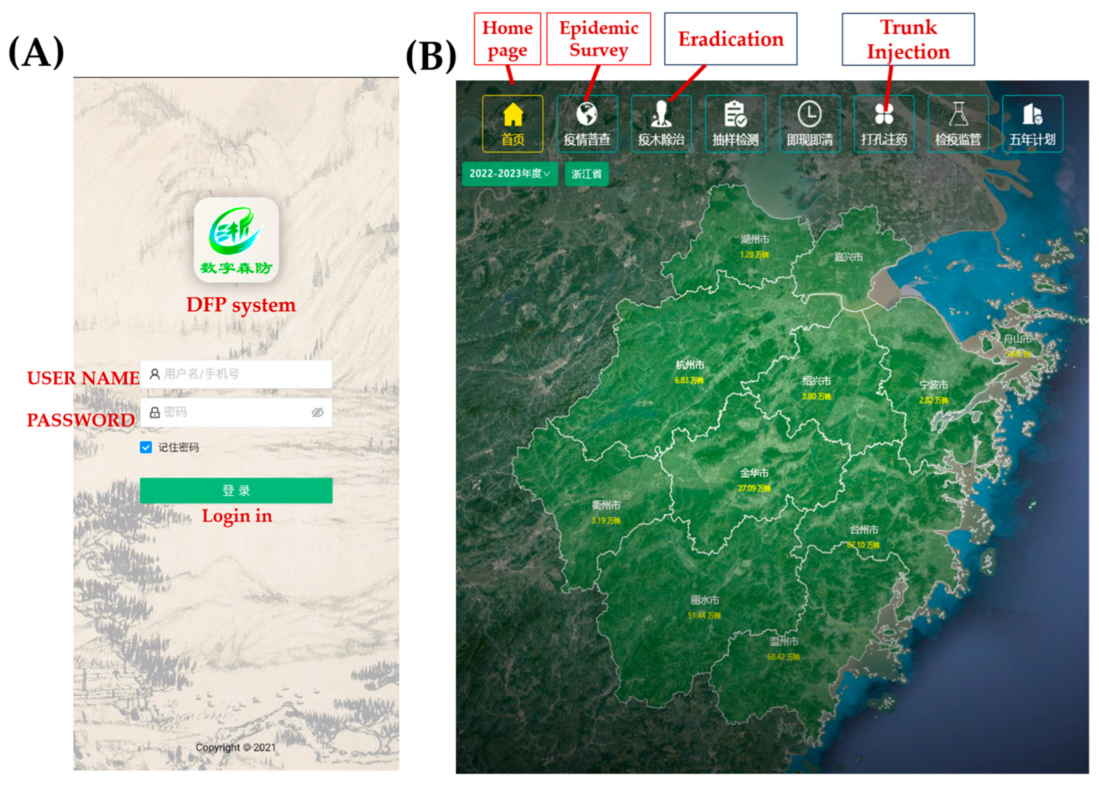
3.1. Development of DFP System

We developed a GIS-based PWD epidemic monitoring system called Digital Forest Protection (DFP) (Figure 1). DFP leverages digital technologies for comprehensive PWD epidemic management, integrating satellite remote sensing, drone inspections, and manual surveys. The collected data were input into the DFP system for real-time monitoring, thereby enhancing PWD management. The DFP system aggregates data from natural resources, market supervision, and Ningbo Customs departments and interacts with national, provincial, city, county, and township data systems, forming a public data platform connected to the National Forestry and Grassland Administration’s PWD monitoring database. A visual operation and mapping system was developed (Figure 2). We created a mobile and web version of the DFP, comprising six modules: PWD epidemic monitoring, eradication, diseased wood, trunk injection, plant quarantine, and quality sampling. The latest version is the DFP v. 123. The system operates on Android phones and functions offline by packaging the area data into a single application package containing textual, image, and map data. Offline data are synchronized with the server once an online connection is available. The server hosts area data packages and stores the collected data.

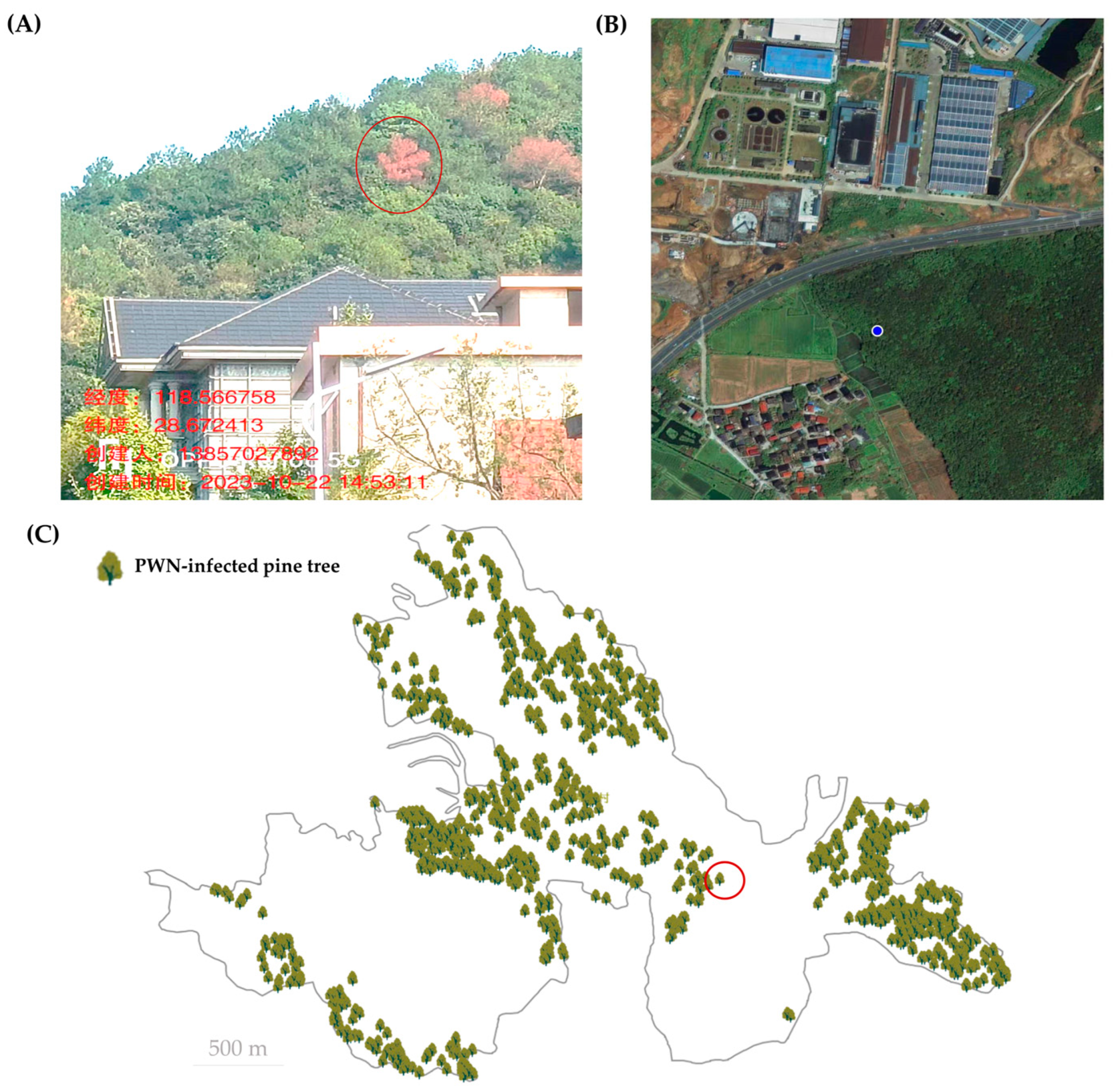
3.2. Data Collection Using Manual Epidemic Survey Module in DFP System

The manual epidemic survey module is a primary method for PWD epidemic data collection. In the field, surveyors utilize the manual epidemic survey module in the DFP system to gather data from PWN-infected pine trees (Figure 3). Upon identifying a pine tree as infected with PWN based on its symptomatic presentation, surveyors capture photographic evidence and document the infected trees within the corresponding forest sub-compartment. Concurrently, they upload pertinent information into the PWD system, including latitude and longitude coordinates, forest compartment, forest sub-compartment, time, and specific symptomatic plots along with the associated photographic documentation.

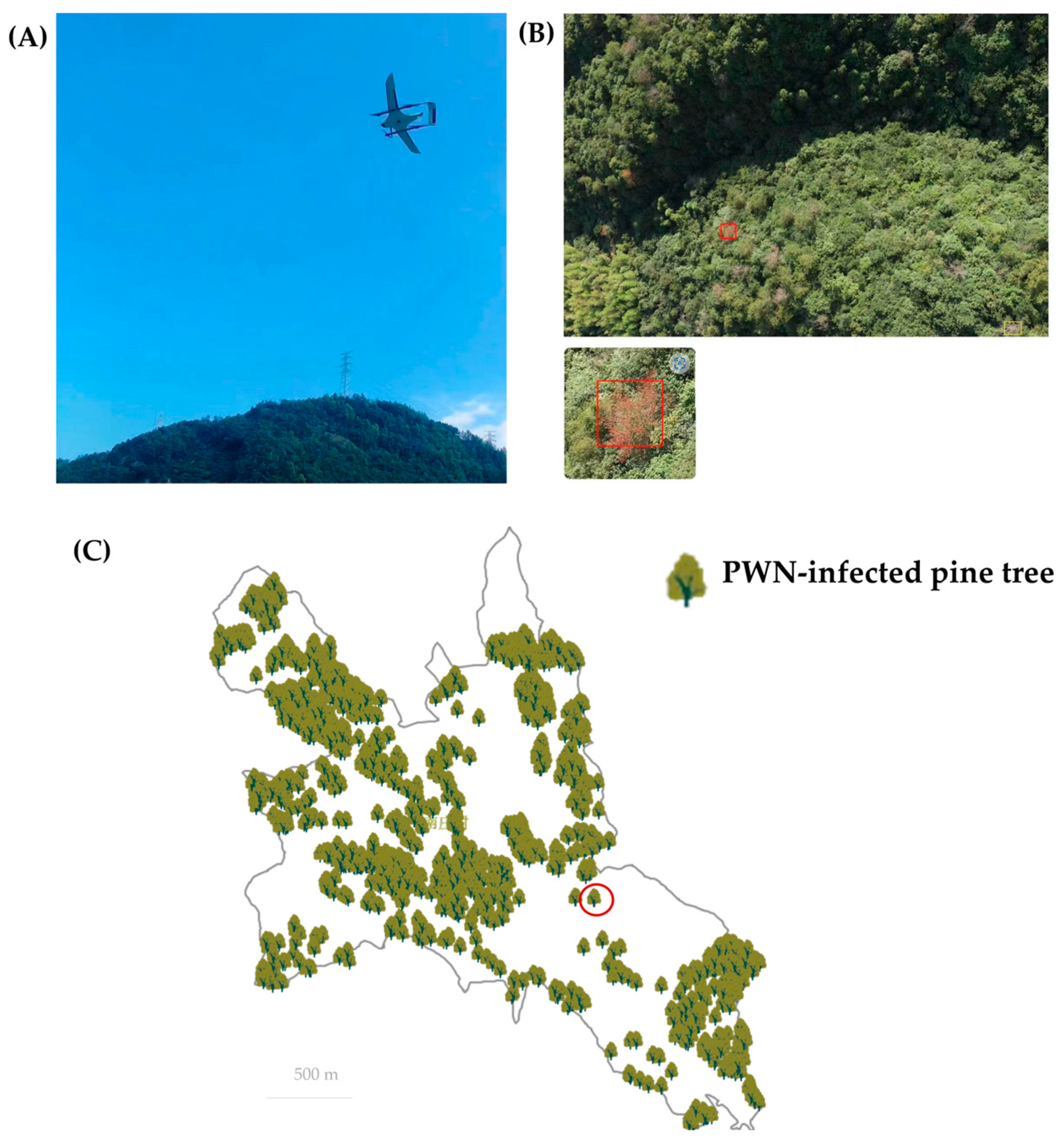
3.3. Data Collection Using UAV Epidemic Survey Module in DFP System

Unmanned aerial vehicles (UAVs) have been extensively utilized in forest survey work in recent years. A UAV epidemic survey module was developed for the pine wilt disease (PWD) epidemic data collection using drones in the DFP system (Figure 4). A detection method based on the YOLO algorithm is employed to identify diseased pine trees in UAV-captured images. The location and additional information of the diseased trees obtained through drone surveys are integrated into the corresponding forest sub-compartment. Direct point calculation is performed using flight Position and Orientation System (POS) data. The accurate implementation of diseased tree surveys based on the CGCS2000 coordinate system to the forest sub-compartment and the precise locations of the individual diseased trees is achieved. Furthermore, the natural attributes such as the land type, forest species, and forest category, as well as management attributes such as the administrative level, are assigned to each identified diseased tree.

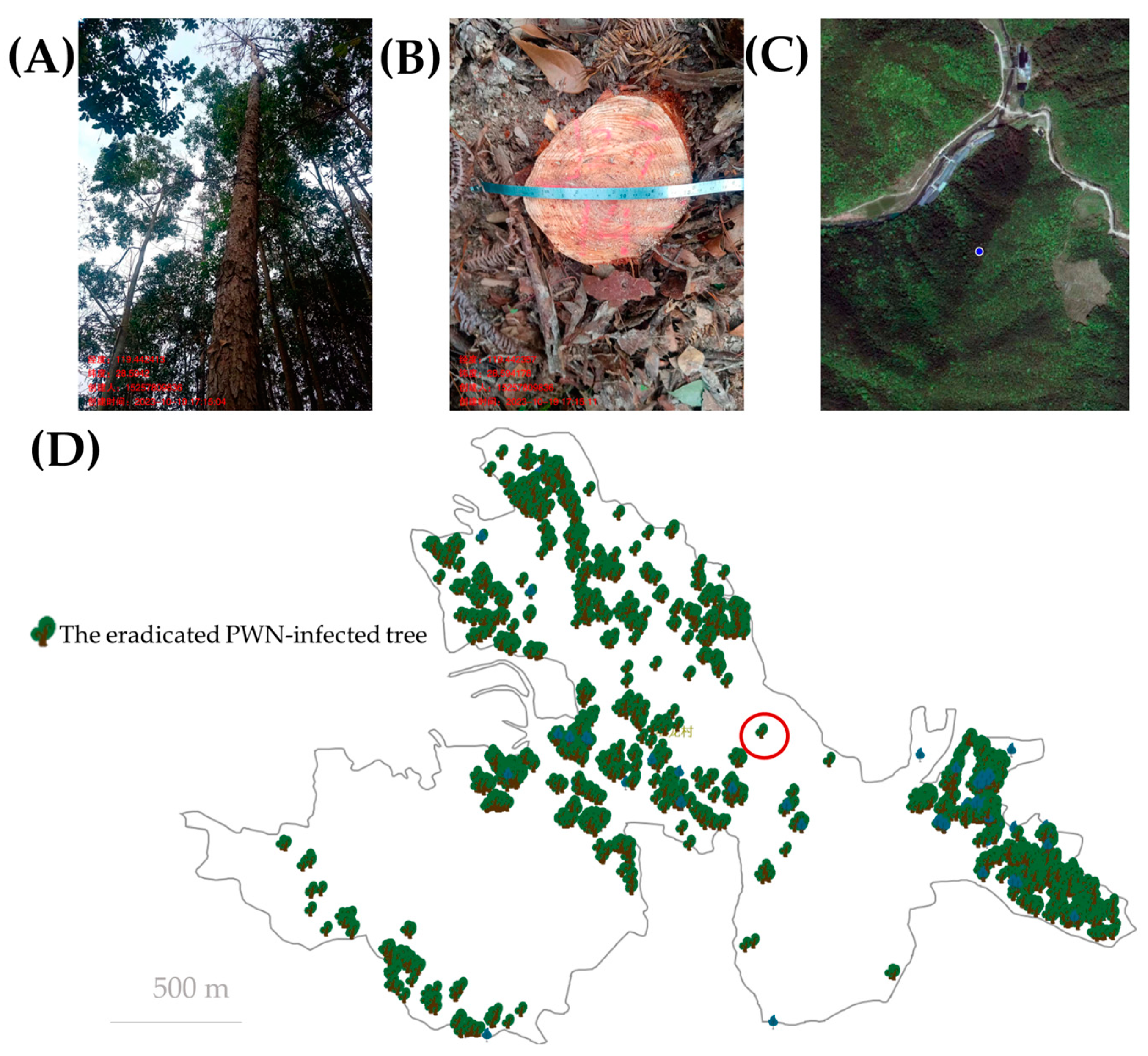
3.4. Eradication Monitoring and Data Collection Module in DFP System

The eradication of deceased pine trees, which contributes to interrupting the disease cycle of PWD, is one of the current PWD integrated management strategies in China. It is essential to monitor the eradication process to prevent the release of insect vectors from the diseased trees. Forest workers upload the fundamental information of each PWD-affected tree to the DFP system through a mobile phone application, including the tree’s serial number, latitude and longitude coordinates, diameter, administrative district, forest sub-compartment, eradication personnel, time, and photographic documentation (Figure 5). Furthermore, to address the issue of poor 4G signals in mountainous areas, a reliable offline operation mode has been developed to ensure that data from remote mountainous regions can be uploaded without loss of information. A regression model correlating the diameter at the breast height of pine trees with the volume and weight has been established to accurately estimate the weight of treated diseased trees, providing robust support for the supervision of the destination of the diseased trees.

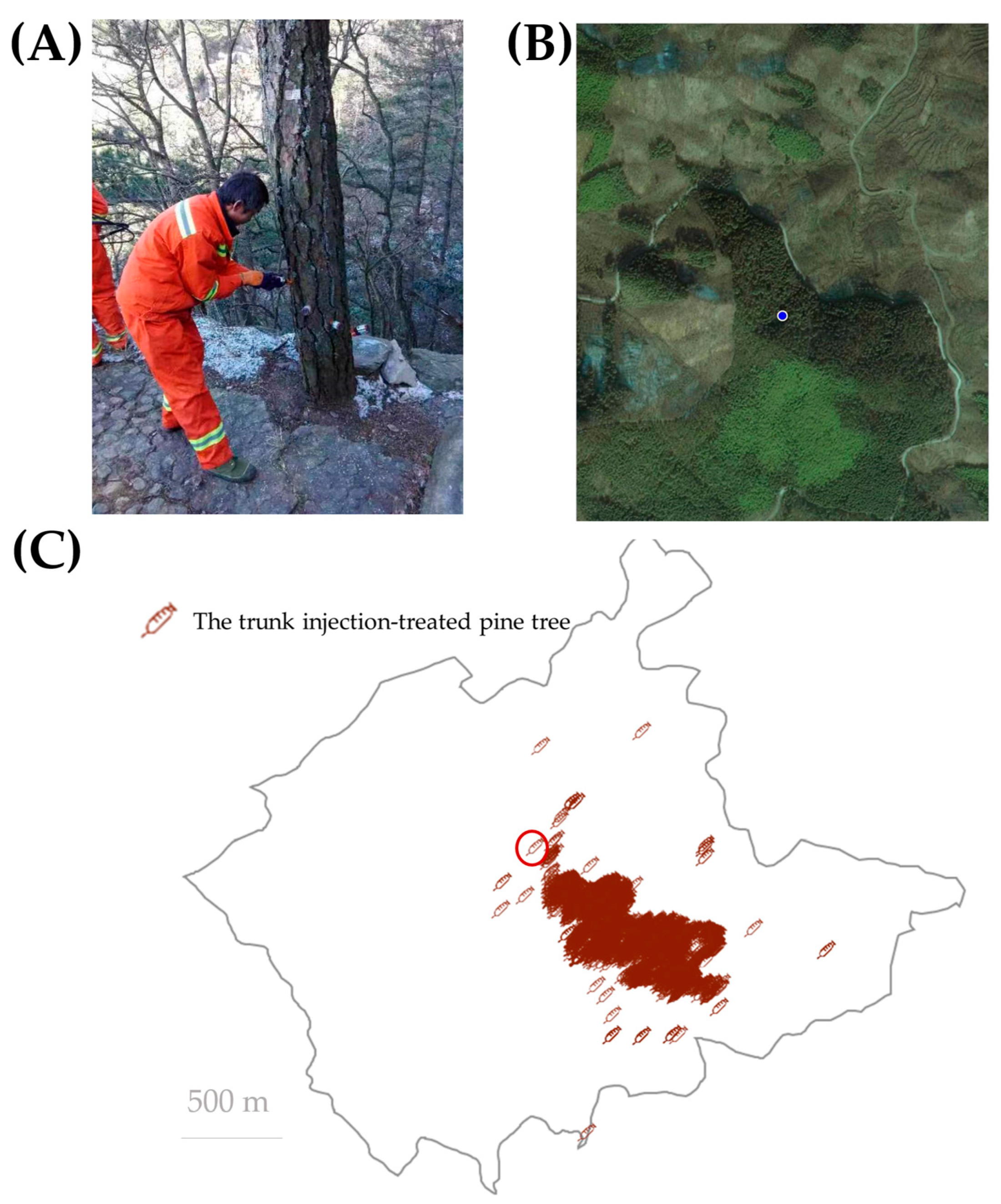
3.5. Trunk Injection Monitoring and Data Collection Module in DFP System

Trunk injection with effective pesticides is a proactive preventive measure against PWD, which constitutes one of the current PWD integrated management strategies in China. It is essential to monitor the healthy trees that have undergone trunk injection treatment. Forest personnel upload the fundamental information of each injected tree to the DFP system via a mobile phone application, including the trunk diameter, geographical coordinates, commercial pesticide information, injection time, and photographic documentation (Figure 6). Each injected pine tree is precisely located and recorded in real-time. The DFP system has accumulated over 13,000,000 images.

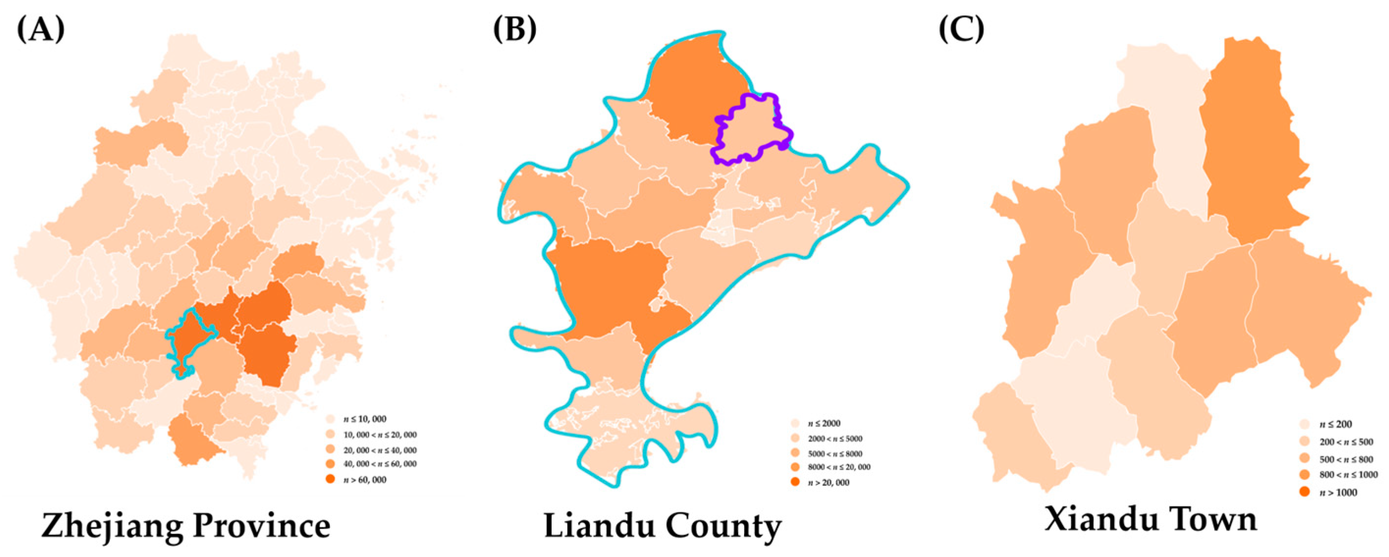
3.6. Epidemic Dynamic of PWD in Different Geographical Scale Based on the DFP System

To date, an excess of 70 million data points and 30 million images have been accumulated within the DFP system. Utilizing this extensive dataset, we have conducted subsequent analysis and research. The heatmap results of the occurrence and prevalence of the epidemic PWD demonstrated that the prevalence of PWD in Zhejiang Province is primarily concentrated in the central and southern regions, with potential for dissemination to surrounding areas if effective measures are not implemented (Figure 7). Furthermore, there exists a risk of dissemination in other locations. Moreover, the epidemiological analysis of PWD could be conducted at multiple levels, including provincial, municipal, county, township, village, and forest unit levels.

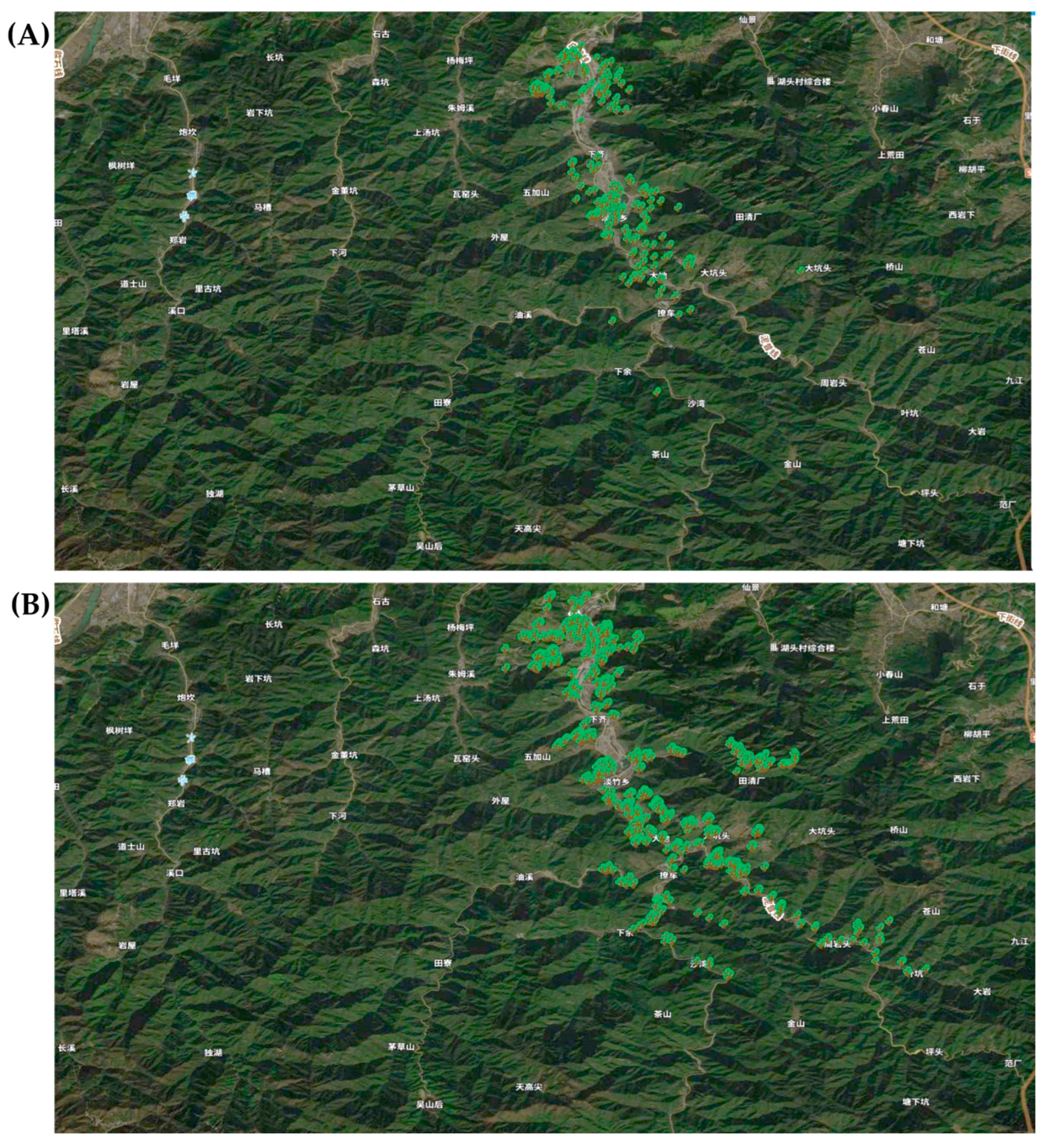
3.7. Spatial Trajectory of PWD Epidemic Based on the DFP System

Following the successful generation of the landing map by the DFP, data analysis indicated that pine wood nematode disease exhibited the potential for rapid dissemination through various routes, including roads and villages (Figure 8). This finding provides evidence supporting the hypothesis that the expeditious spread of PWD occurs via road networks, villages, and other pathways.

4. Discussion

In this study, we present a new intelligent system, DFP, for the monitoring of PWD in China. The developed system was designed for the data collection and analysis of PWD regarding the forest preferences in any area of interest for forestry professionals and administrators. In accordance with the requirements for monitoring and managing the PWD epidemic in China, the DFP system comprises a DFP app and a unified database. The DFP app could be customized for collecting local PWD data using a manual epidemic survey and a UAV epidemic survey, which are crucial for the management of PWD [4,32,33]. Furthermore, PWD epidemic levels are contingent upon the efficiency of disease control application [34]. In the current PWD management strategy, the eradication of the inoculant and trunk injection to prevent infection are two of the main methods [2,4]. Our system facilitates data collection from the eradication and trunk injection, which could contribute to PWD monitoring under the management circumstance. The DFP application scenarios underwent a total of 123 iterations and upgrades, with 2331 administrators registered at the provincial, city, county, and township levels, 11,755 business personnel, and 736 enterprises.
In the epidemic survey module of the DFP system, detailed information, including the latitude and longitude, forest compartment, sub-compartment number, sub-compartment area, pine tree percentage, forest category, symptoms of infected pine trees, and photographs, will be uploaded or automatically acquired. The precise location of the PWD-infected pine trees is crucial for assessing the risk of PWD and designing appropriate management strategies [33,35]. According to the disease cycle pattern of PWD in Zhejiang Province, the primary transmission vector, M. alternatus, oviposits within infected pine trees and overwinter, with the subsequent emergence and dissemination of PWD the following year. Consequently, the precise location of PWD-infected pine trees could contribute to the development of an efficient management strategy in this specific forest area in late autumn or early winter of the same year [36]. For this purpose, over 3.9 million and over 2.52 million infected pine trees were located precisely in the DFP system in Zhejiang Province during 2021 and 2022, respectively. These data provide significant and adequate support to prevent and control the spread of PWD.
Enhancing artificial intelligence algorithms through advanced image recognition techniques, particularly semantic segmentation, can significantly improve the accuracy of detecting PWD in forest ecosystems [16,24,29]. The integration of semantic segmentation in artificial intelligence-driven image recognition algorithms holds the potential to revolutionize the early diagnosis and progression monitoring of PWD [17,37]. Moreover, developing sophisticated image recognition algorithms that incorporate semantic segmentation can lead to more precise and reliable identification of PWD symptoms across various stages of the condition [38]. In our system, the YOLO models were applied in identifying PWD—symptomatic pine trees from UAV images—and showed high efficiency in data collection.
PWD vectors oviposit within infected pine trees, facilitating the entry of nematodes into their larval bodies and promoting their dissemination and spread during larval emergence [5,39,40]. Consequently, the eradication of infected trees can effectively eliminate the inoculum of PWN and reduce the population density of vector insects in the forest, thereby disrupting the PWD cycle [41,42,43]. In our data collection module for the elimination of infected trees, we recorded detailed information about each eradicated tree, including their latitude and longitude, forest class, sub-compartment, tree diameter, and information on the elimination personnel. Furthermore, to accurately determine if the infected trees have been removed from the pine forest, we uploaded transportation vehicle information, inspection management information, and other relevant data. During the data collection surveys for the elimination of infected trees in 2021 and 2022, we geolocated all the infected pine trees in the DFP system and visualized the survey data. These point-to-point data provide crucial support for monitoring eradication efficiency in the integrated management of PWD [11].
Trunk injection is another crucial measure against PWD infections in healthy trees [44,45]. Currently, the primary pesticides used for trunk injection in China are emamectin benzoate and avermectin [44]. These pesticides, formulated as microemulsions or emulsifiable concentrates, are introduced into the xylem of tree trunks to inhibit the growth and reproduction of the vector M. alternatus and PWN within pine trees [46]. To analyze the efficacy of the application, it is essential to monitor the growth of healthy pine trees treated with trunk injections. Consequently, we developed a trunk injection module in the DFP system, which encompasses information such as the location of the injected pine trees, trunk diameters, the product information of the injected pesticide, and the injection time. These data facilitate a more comprehensive understanding of the impact of trunk injections on PWD management.
Adequate and accurate data are fundamental for investigating the epidemic patterns of forest pests and diseases [47,48]. The DFP system amassed over 70 million data records pertaining to the PWD epidemic in Zhejiang Province and over 30 million images. These comprehensive data facilitate the examination of the occurrence and epidemic dynamics of PWD on multiple scales [49,50,51]. Utilizing these extensive datasets, we established the dynamic patterns of the epidemic distribution and the spatiotemporal development of PWD at various administrative levels, including provinces, cities, counties, townships, and villages. For instance, by analyzing the epidemic dynamics at fixed points over time, we identified the phenomenon of PWD propagation along road networks, corroborating previous reports [8,52,53,54]. These data provide crucial technical support for PWD management on a large geographical scale [34,55].
In future research, the focus will be on automating the decision-making system, which involves leveraging analyzed data and observed patterns to automatically suggest control strategies tailored to each situation in the DFP system. This approach utilizes advanced analytics and machine learning to correlate real-time and historical data with a comprehensive library of control strategies, generating tailored recommendations that can enhance decision-making processes [10]. Consequently, this method has the potential to improve efficiency, accuracy, scalability, and adaptability in addressing complex challenges [33].

5. Conclusions

The DFP system developed in this study integrates the data collection, epidemic monitoring, eradication monitoring, and decision-making of PWD management in Zhejiang Province, China. The implemented application is supported by advanced information technologies such as GPS global positioning, GIS geographic information, intelligent technology, visualization, cloud computing, and big data analysis. With the extensive application of DFP in the PWD data collection and epidemic analysis, a closed-loop management model based on “disease survey–risk analysis–decision-making–monitoring” has also been proposed and implemented. These technical advancements have significantly enhanced the efficiency of the monitoring and management of PWD. Based on the DFP system, every diseased pine trees caused by PWD in Zhejiang Province had been located, which has substantially improved the capability of PWD epidemic monitoring and management.

Author Contributions

Conceptualization, Y.W. and J.H.; methodology, Y.Z. and Y.W.; validation, Y.Z., W.C., J.H. and Y.W.; formal analysis, Y.Z., W.C., J.H. and Y.W.; investigation, Y.Z., W.C., J.H. and Y.W.; resources, J.H. and Y.W.; data curation, Y.Z.; writing—original draft preparation, Y.Z.; writing—review and editing, Y.W.; visualization, Y.Z., W.C., J.H. and Y.W.; supervision, J.H. and Y.W.; funding acquisition, J.H. and Y.W. All authors have read and agreed to the published version of the manuscript.

Funding

This research was funded by a grant from Zhejiang Provincial Forestry Bureau Key Technologies R and D Program (2024LYYJ01) and a grant from Central Financial Forestry Science and Technology Promotion Demonstration Fund Project of China (2023TS02).

Data Availability Statement

The original contributions presented in this study are included in the article. Further inquiries can be directed to the corresponding authors.

Acknowledgments

We thank Li Xie (Zhejiang Provincial Forest Disease and Pest Control Station) for his technical assistance.

Conflicts of Interest

The authors declare no conflicts of interest.

References

  1. Mariette, N.; Hotte, H.; Chappé, A.-M.; Grosdidier, M.; Anthoine, G.; Sarniguet, C.; Colnard, O.; Kersaudy, E.; Paris, M.-T.; Koen, E.; et al. Two decades of epidemiological surveillance of the pine wood nematode in France reveal its absence despite suitable conditions for its establishment. Ann. For. Sci. 2023, 80, 21. [Google Scholar] [CrossRef]
  2. EPPO. Bursaphelenchus xylophilus and its vectors: Procedures for official control. EPPO Bull. 2012, 42, 477–485. [Google Scholar] [CrossRef]
  3. Vicente, C.; Espada, M.; Vieira, P.; Mota, M. Pine wilt disease: A threat to European forestry. Eur. J. Plant Pathol. 2011, 133, 89–99. [Google Scholar] [CrossRef]
  4. Ye, J.R. Epidemic status of pine wilt disease in China and its prevention and control techniques and counter measures. Sci. Silvae Sin. 2019, 55, 1. [Google Scholar]
  5. Zhao, L.L.; Mota, M.; Vieira, P.; Butcher, R.A.; Sun, J.H. Interspecific communication between pinewood nematode, its insect vector, and associated microbes. Trends Parasitol. 2014, 30, 299–308. [Google Scholar] [CrossRef]
  6. Liu, F.; Su, H.J.; Ding, T.T.; Huang, J.X.; Liu, T.; Ding, N.; Fang, G.F. Refined assessment of economic loss from pine wilt disease at the subcompartment scale. Forests 2023, 14, 139. [Google Scholar] [CrossRef]
  7. Futai, K. Pine Wood Nematode, Bursaphelenchus xylophilus. Annu. Rev. Phytopathol. 2013, 51, 61–83. [Google Scholar] [CrossRef]
  8. Rands, S.; Robinet, C.; Roques, A.; Pan, H.; Fang, G.; Ye, J.; Zhang, Y.; Sun, J. Role of human-mediated dispersal in the spread of the pinewood nematode in China. PLoS ONE 2009, 4, e4646. [Google Scholar] [CrossRef]
  9. Li, M.; Li, H.; Ding, X.L.; Wang, L.C.; Wang, X.Y.; Chen, F.M. The detection of pine wilt disease: A literature review. Int. J. Mol. Sci. 2022, 23, 10797. [Google Scholar] [CrossRef]
  10. Back, M.A.; Bonifácio, L.; Inacio, M.L.; Mota, M.; Boa, E. Pine wilt disease: A global threat to forestry. Plant Pathol. 2024, 73, 1026–1041. [Google Scholar] [CrossRef]
  11. Barzman, M.; Bàrberi, P.; Birch, A.N.E.; Boonekamp, P.; Dachbrodt-Saaydeh, S.; Graf, B.; Hommel, B.; Jensen, J.E.; Kiss, J.; Kudsk, P.; et al. Eight principles of integrated pest management. Agron. Sustain. Dev. 2015, 35, 1199–1215. [Google Scholar] [CrossRef]
  12. Akbulut, S.; Stamps, W.T. Insect vectors of the pinewood nematode: A review of the biology and ecology of Monochamus species. For. Pathol. 2012, 42, 89–99. [Google Scholar] [CrossRef]
  13. Kangas, A.; Rasinmäki, J.; Eyvindson, K.; Chambers, P. A mobile phone application for the collection of opinion data for forest planning purposes. Environ. Manag. 2015, 55, 961–971. [Google Scholar] [CrossRef] [PubMed]
  14. Gupta, A.; Mora, S.; Preisler, Y.; Duarte, F.; Prasad, V.; Ratti, C. Tools and methods for monitoring the health of the urban greenery. Nat. Sustain. 2024, 7, 536–544. [Google Scholar] [CrossRef]
  15. Keefe, R.F.; Wempe, A.M.; Becker, R.M.; Zimbelman, E.G.; Nagler, E.S.; Gilbert, S.L.; Caudill, C.C. Positioning methods and the use of location and activity data in forests. Forests 2019, 10, 458. [Google Scholar] [CrossRef]
  16. Iordache, M.D.; Mantas, V.; Baltazar, E.; Pauly, K.; Lewyckyj, N. A machine learning approach to detecting pine wilt disease using airborne spectral imagery. Remote Sens. 2020, 12, 2280. [Google Scholar] [CrossRef]
  17. Jung, S.K.; Park, S.B.; Shim, B.S. Diagnosis of pine wilt disease using remote wireless sensing. PLoS ONE 2021, 16, e0257900. [Google Scholar] [CrossRef] [PubMed]
  18. Yu, R.; Luo, Y.Q.; Zhou, Q.; Zhang, X.D.; Wu, D.W.; Ren, L.L. Early detection of pine wilt disease using deep learning algorithms and UAV-based multispectral imagery. Forest Ecol. Manag. 2021, 497, 119493. [Google Scholar] [CrossRef]
  19. Li, F.D.; Liu, Z.Y.; Shen, W.X.; Wang, Y.; Wang, Y.L.; Ge, C.K.; Sun, F.G.; Lan, P. A remote sensing and airborne edge-computing based detection system for pine wilt disease. IEEE Access 2021, 9, 66346–66360. [Google Scholar] [CrossRef]
  20. Lim, W.; Choi, K.; Cho, W.; Chang, B.; Ko, D.W. Efficient dead pine tree detecting method in the forest damaged by pine wood nematode (Bursaphelenchus xylophilus) through utilizing unmanned aerial vehicles and deep learning-based object detection techniques. For. Sci. Technol. 2022, 18, 36–43. [Google Scholar] [CrossRef]
  21. Qin, J.; Wang, B.; Wu, Y.L.; Lu, Q.; Zhu, H.C. Identifying pine wood nematode disease using UAV images and deep learning algorithms. Remote Sens. 2021, 13, 162. [Google Scholar] [CrossRef]
  22. Zhang, B.Y.; Ye, H.C.; Lu, W.; Huang, W.J.; Wu, B.; Hao, Z.Q.; Sun, H. A spatiotemporal change detection method for monitoring pine wilt disease in a complex landscape using high-resolution remote sensing imagery. Remote Sens. 2021, 13, 2083. [Google Scholar] [CrossRef]
  23. Tahir, S.; Hassan, S.S.; Yang, L.; Ma, M.; Li, C. Detection Methods for Pine Wilt Disease: A Comprehensive Review. Plants 2024, 13, 2876. [Google Scholar] [CrossRef] [PubMed]
  24. Deng, X.; Tong, Z.; Lan, Y.; Huang, Z. Detection and location of dead trees with pine wilt disease based on deep learning and UAV remote sensing. AgriEngineering 2020, 2, 294–307. [Google Scholar] [CrossRef]
  25. Liu, B.; Liu, L.Y.; Zhuo, R.; Chen, W.D.; Duan, R.; Wang, G.S. A dataset for forestry pest identification. Front. Plant Sci. 2022, 13, 857104. [Google Scholar] [CrossRef] [PubMed]
  26. Liu, Y.; Liu, S.; Xu, J.W.; Kong, X.N.; Xie, L.; Chen, K.Y.; Liao, Y.Y.; Fan, B.W.; Wang, K.L. Forest pest identification based on a new dataset and convolutional neural network model with enhancement strategy. Comput. Electron. Agric. 2022, 192, 106625. [Google Scholar] [CrossRef]
  27. Zhou, H.W.; Xie, M.; Koski, T.M.; Li, Y.S.; Zhou, H.; Song, J.Y.; Gong, C.Q.; Fang, G.F.; Sun, J.H. Epidemiological model including spatial connection features improves prediction of the spread of pine wilt disease. Ecol. Indic. 2024, 163, 112103. [Google Scholar] [CrossRef]
  28. Tan, C.; Lin, Q.N.; Du, H.Q.; Chen, C.; Hu, M.C.; Chen, J.J.; Huang, Z.H.; Xu, Y.X. Detection of the infection stage of pine wilt disease and spread distance using monthly UAV-based imagery and a deep learning approach. Remote Sens. 2024, 16, 364. [Google Scholar] [CrossRef]
  29. Syifa, M.; Park, S.J.; Lee, C.W. Detection of the pine wilt disease tree candidates for drone remote sensing using artificial intelligence techniques. Engineering 2020, 6, 919–926. [Google Scholar] [CrossRef]
  30. Wu, W.; Zhang, Z.; Zheng, L.; Han, C.; Wang, X.; Xu, J.; Wang, X. Research progress on the early monitoring of pine wilt disease using hyperspectral techniques. Sensors 2020, 20, 3729. [Google Scholar] [CrossRef]
  31. Lai, Y.; Zhai, J.; Zhou, C.; Xia, Z. The first detection of pine wilt disease in Xiangshan county, Zhejiang Province. Plant Quar. 1993, 1, 38. [Google Scholar]
  32. Ikeda, T. Integrated pest management of Japanese pine wilt disease. Eur. J. For. Pathol. 2007, 14, 398–414. [Google Scholar] [CrossRef]
  33. Xu, Q.W.; Zhang, X.J.; Li, J.X.; Ren, J.R.; Ren, L.L.; Luo, Y.Q. Pine wilt disease in Northeast and Northwest China: A comprehensive risk review. Forests 2023, 14, 174. [Google Scholar] [CrossRef]
  34. Hao, Z.Q.; Huang, J.X.; Li, X.D.; Sun, H.; Fang, G.F. A multi-point aggregation trend of the outbreak of pine wilt disease in China over the past 20 years. Forest Ecol. Manag. 2022, 505, 119890. [Google Scholar] [CrossRef]
  35. Zhao, H.; Xian, X.; Yang, N.; Guo, J.; Zhao, L.; Shi, J.; Liu, W.-X. Risk assessment framework for pine wilt disease: Estimating the introduction pathways and multispecies interactions among the pine wood nematode, its insect vectors, and hosts in China. Sci. Total Environ. 2023, 905, 167075. [Google Scholar] [CrossRef] [PubMed]
  36. Chen, Y.Q.; Yan, E.P.; Jiang, J.W.; Zhang, G.Z.; Mo, D.K. An efficient approach to monitoring pine wilt disease severity based on random sampling plots and UAV imagery. Ecol. Indic. 2023, 156, 111215. [Google Scholar] [CrossRef]
  37. Li, H.; Chen, L.; Yao, Z.; Li, N.; Long, L.; Zhang, X. Intelligent Identification of Pine Wilt Disease Infected Individual Trees Using UAV-Based Hyperspectral Imagery. Remote Sens. 2023, 15, 3295. [Google Scholar] [CrossRef]
  38. Huo, L.N.; Lindberg, E.; Bohlin, J.; Persson, H.J. Assessing the detectability of European spruce bark beetle green attack in multispectral drone images with high spatial- and temporal resolutions. Remote Sens. Environ. 2023, 287, 113484. [Google Scholar] [CrossRef]
  39. Mamiya, Y. Pathology of the pine wilt disease caused by Bursaphelenchus xylophilus. Annu. Rev. Phytopathol. 1983, 21, 201–220. [Google Scholar] [CrossRef]
  40. Togashi, K.; Shigesada, N. Spread of the pinewood nematode vectored by the Japanese pine sawyer: Modeling and analytical approaches. Popul. Ecol. 2006, 48, 271–283. [Google Scholar] [CrossRef]
  41. Gordillo, L.F.; Kim, Y. A simulation of the effects of early eradication of nematode infected trees on spread of pine wilt disease. Eur. J. Plant Pathol. 2012, 132, 101–109. [Google Scholar] [CrossRef]
  42. Genovesi, P. Eradications of invasive alien species in Europe: A review. Biol. Invasions 2005, 7, 127–133. [Google Scholar] [CrossRef]
  43. Rodrigues, J.M. National Eradication Programme for the Pinewood Nematode. In Pine Wilt Disease: A Worldwide Threat to Forest Ecosystems; Mota, M.M., Vieira, P., Eds.; Springer: Berlin/Heidelberg, Germany, 2008; pp. 5–14. [Google Scholar]
  44. Wang, Y.J.; Tang, G.H.; Chen, Z.H.; Chen, A.L. Advanced research of trunk injection against pine wild disease. For. Pest Dis. 2022, 41, 59–63. [Google Scholar] [CrossRef]
  45. Takai, K.; Suzuki, T.; Kawazu, K. Development and preventative effect against pine wilt disease of a novel liquid formulation of emamectin benzoate. Pest Manag. Sci. 2003, 59, 365–370. [Google Scholar] [CrossRef]
  46. Zhang, W.J.; Wu, X.Q.; Ye, J.R.; Li, C.Q.; Hu, L.J.; Rui, L.; Zhang, Y.; Shi, X.F.; Wang, L. Toxicity of an emamectin benzoate microemulsion against and its effect on the prevention of pine wilt disease. Forests 2023, 14, 1476. [Google Scholar] [CrossRef]
  47. Lu, X.; Huang, J.X.; Li, X.D.; Fang, G.F.; Liu, D.Q. The interaction of environmental factors increases the risk of spatiotemporal transmission of pine wilt disease. Ecol. Indic. 2021, 133, 108394. [Google Scholar] [CrossRef]
  48. Yoon, S.; Jung, J.M.; Hwang, J.; Park, Y.; Lee, W.H. Ensemble evaluation of the spatial distribution of pine wilt disease mediated by insect vectors in South Korea. Forest Ecol. Manag. 2023, 529, 120677. [Google Scholar] [CrossRef]
  49. Matsuhashi, S.; Hirata, A.; Akiba, M.; Nakamura, K.; Oguro, M.; Takano, K.T.; Nakao, K.; Hijioka, Y.; Matsui, T. Developing a point process model for ecological risk assessment of pine wilt disease at multiple scales. Forest Ecol. Manag. 2020, 463, 118010. [Google Scholar] [CrossRef]
  50. Yu, L.; Zhan, Z.; Ren, L.; Li, H.; Huang, H.; Luo, Y. Impact of stand- and landscape-level variables on pine wilt disease-caused tree mortality in pine forests. Pest Manag. Sci. 2023, 79, 1791–1799. [Google Scholar] [CrossRef]
  51. Takasu, F. Individual-based modeling of the spread of pine wilt disease: Vector beetle dispersal and the Allee effect. Popul. Ecol. 2009, 51, 399–409. [Google Scholar] [CrossRef]
  52. Xiao, Y.; Guo, Q.; Xie, N.; Yuan, G.; Liao, M.; Gui, Q.; Ding, G. Predicting the global potential distribution of Bursaphelenchus xylophilus using an ecological niche model: Expansion trend and the main driving factors. BMC Ecol. Evol. 2024, 24, 48. [Google Scholar] [CrossRef] [PubMed]
  53. Hao, Z.Q.; Huang, J.X.; Zhou, Y.T.; Fang, G.F. Spatiotemporal pattern of pine wilt disease in the Yangtze river basin. Forests 2021, 12, 731. [Google Scholar] [CrossRef]
  54. Yoshimura, A.; Kawasaki, K.; Takasu, F.; Togashi, K.; Futai, K.; Shigesada, N. Modeling the spread of pine wilt disease caused by nematodes with pine sawyers as vector. Ecology 1999, 80, 1691–1702. [Google Scholar] [CrossRef]
  55. Yoon, S.; Hwang, J.; Park, Y.; Lee, W.H. Analysis of the spread distance of pine wilt disease based on a high volume of spatiotemporal data recording of infected trees. Forest Ecol. Manag. 2024, 553, 121612. [Google Scholar] [CrossRef]
Figure 1. The workflow of the Digital Forest Protection system.
Forests 15 02174 g001
Figure 2. Login interface of Digital Forest Protection (DFP) system. (A) Login interface (left) and main menu of the DFP App. (B) Web vision of DFP system.
Forests 15 02174 g002
Figure 3. The map view of the manual epidemic survey in forest and the data collection for the pine wilt disease epidemic monitoring in the Digital Forest Protection (DFP) system. (A) A PWN-infected pine tree was detected (encircled); (B) The information of this PWN-infected pine tree was collected, including latitude and longitude coordinates, time, and symptoms through DFP App. (C) This PWN-infected pine tree was located on the DFP map system (encircled). All the detected PWN-infected pine trees in this village were located and labeled in the DFP map system.
Forests 15 02174 g003
Figure 4. The map view of the UAV epidemic survey using drones in forest and the data collection for the PWD epidemic monitoring in the Digital Forest Protection (DFP) system. (A) A drone working on PWD detection in the forest; (B) the AI-based detection of pine trees infected with PWD. (C) This PWN-infected pine tree was located on the DFP map system (encircled). All the detected PWN-infected pine trees in this village were located and labeled in the DFP map system.
Forests 15 02174 g004
Figure 5. The map view of the eradication monitoring in the forest and data collection for PWD epidemic monitoring in the Digital Forest Protection (DFP) system. (A) A PWN-infected tree needed to be eradicated in the forest. (B) The stump after this PWN-infected pine tree. (C) The information of this eradicated PWN-infected tree was inputted, including the latitude and longitude coordinates, trunk diameter, weight, and personnel involved. (D) This eradicated PWN-infected pine tree was located on the DFP map system (encircled). All the eradicated PWN-infected pine trees in this village were located and labeled in the DFP map system.
Forests 15 02174 g005
Figure 6. The map view of the truck injection in the forest and data collection for PWD epidemic monitoring in the Digital Forest Protection (DFP) system. (A) The trunk injection for PWD management in the forest. (B) The information of this injected pine tree was inputted, including the trunk diameter, geographical coordinates, pesticide, and injection time. (C) This trunk injection-treated pine tree was located on the DFP map system (encircled). All the trunk injection-treated pine trees in this village were located and labeled in the DFP map system.
Forests 15 02174 g006
Figure 7. Analysis of epidemic in Zhejiang Province in the Digital Forest Protection system at the provincial (A), county (B), and town (village) (C) levels.
Forests 15 02174 g007
Figure 8. An example of the rapid dissemination of PWD via road networks from 2021 (A) to 2022 (B). The green points indicate the PWN-infected pine trees in the Digital Forest Protection system.
Forests 15 02174 g008
Disclaimer/Publisher’s Note: The statements, opinions and data contained in all publications are solely those of the individual author(s) and contributor(s) and not of MDPI and/or the editor(s). MDPI and/or the editor(s) disclaim responsibility for any injury to people or property resulting from any ideas, methods, instructions or products referred to in the content.

