Article

Construction of a Wi-Fi System with a Tethered Balloon in a Mountainous Region for the Teleoperation of Vehicular Forestry Machines

1
Forest Technology and Management Research Center, National Institute of Forest Science, Pocheon 11187, Republic of Korea
2
Department of Biosystems Engineering, Kangwon National University, Chuncheon 24341, Republic of Korea
3
Interdisciplinary Program in Smart Agriculture, Graduate School, Kangwon National University, Chuncheon 24341, Republic of Korea
*
Authors to whom correspondence should be addressed.
Forests 2024, 15(11), 1994; https://doi.org/10.3390/f15111994
Submission received: 27 September 2024 / Revised: 31 October 2024 / Accepted: 9 November 2024 / Published: 12 November 2024
(This article belongs to the Section Forest Operations and Engineering)

Abstract

:
In this study, a Wi-Fi system with a tethered balloon is proposed for the teleoperation of vehicular forestry machines. This system was developed to establish a Wi-Fi communication for stable teleoperation in a timber harvesting site. This system consisted of a helium balloon, Wi-Fi nodes, a measurement system, a global navigation satellite system (GNSS) antenna, and a wind speed sensor. The measurement system included a GNSS module, an inertial measurement unit (IMU), a data logger, and an altitude sensor. While the helium balloon with the Wi-Fi system was 60 m in the air, the received signal strength indicator (RSSI) was measured by moving a Wi-Fi receiver on the ground. Another GNSS set was also utilized to collect the latitude and longitude data from the Wi-Fi receiver as it traveled. The developed Wi-Fi system with a tethered balloon can create a Wi-Fi zone of up to 1.9 ha within an average wind speed range of 2.2 m/s. It is also capable of performing the teleoperation of vehicular forestry machines with a maximum latency of 185.7 ms.

1. Introduction

In forestry, felling operations are critical in the process of timber harvesting and preliminary processing, and they are mainly performed by humans using chainsaws. [1,2,3]. However, inexperienced operators are vulnerable to fatal accident risks caused during chainsaw operations [4]. A method to reduce safety accidents in logging operations using chainsaws is to carry out projects that encourage mechanized work using vehicular forestry machines [5]. However, during the execution of these projects, operators have been vulnerable to equipment rollover accident risks [6]. Teleoperation has been highlighted as a measure to reduce safety accidents caused by equipment rollover [7].
As a method to control machines from a distance via a monitor screen [8], teleoperation has been applied to diverse industries, including agriculture, healthcare, and construction, facilitating the development of unmanned technologies [9]. Likewise, the forestry field has continuously researched teleoperation. Westerberg et al. [10] developed a system that can control a forwarder’s crane with a joystick by constructing a virtual environment on the monitor screen. Although the monitor shows the virtual environment (rather than the actual environment), it is possible to visualize the trajectory of the crane with the joystick in this environment. Milne et al. [11] proposed a teleoperation system for harvesters and forwarders utilizing internet communication technologies. They also analyzed the average latency of various protocols, such as TCP/IP, UDP, and ISDN, which can be used in internet communications to identify suitable protocols for teleoperation. Kim et al. [12] developed a teleoperation system for the tree harvester. The operator controlled the harvester at a distance from a station with a monitor and joystick, where Wi-Fi was utilized for wireless communications. The performance of the system was evaluated by measuring the latency of the control signals and image signals transmitted and received via Wi-Fi. Even though the performance of the teleoperation system when used in diverse field conditions was not evaluated, it was confirmed that the teleoperation system could be applied to several logging sites in Korea. As such, the forestry field has researched teleoperation for the sake of the safety of operators.
Teleoperation requires stable wireless communication technologies to prevent operational delays and malfunction [13]. However, it is difficult to build stable wireless communication in forests because factors such as terrain, trees, and leaves diffract, spread, and reflect the frequency of wireless communication [14]. Once the harvesting area is determined, the harvester moves while felling the trees in the case of clear-cuts. Thus, the teleoperation environment is similar to an open area environment rather than a forest, in which obstacles may exist [12]. The terrain should be considered when constructing wireless communication in an open area environment [15]. Among terrain elements, hills can block the line of sight (LOS) of wireless communication and hinder stable wireless communications [16]. In the previous study (Kim et al. [12]), we built a system that allows teleoperation from the console station to the vehicular forestry machine using Wi-Fi direct, a one-to-one connection method using a single Wi-Fi node and receiver. There was a clear limitation in the teleoperation when the communication was cut off in hilly terrain because the LOS was blocked. To overcome this limitation, an ad hoc network was adopted. The ad hoc network is a method of configuring wireless communication coverage by connecting multiple wireless communication nodes to each other. By placing wireless communication nodes in areas where the LOS is blocked, wider coverage can be created than with Wi-Fi direct [17]. Wireless communication nodes are connected in mesh form to build a communication network, and Wi-Fi nodes can also form mesh Wi-Fi. To cover a large area in hilly terrain, as many Wi-Fi nodes should be installed as possible. It was determined that configuring mesh Wi-Fi on the ground would be difficult to apply due to the installation itself and battery management of the Wi-Fi nodes. Therefore, we reached the conclusion that the problem could be solved by gathering Wi-Fi nodes together, arranging them appropriately in space to form a mesh Wi-Fi, and then using a helium balloon to fly high in the air.
An aerial vehicle can be utilized to construct stable wireless communications in hilly terrain. If antennas are installed on an aerial vehicle, the problem of securing the LOS due to hills can be minimized [18]. Various aerial vehicle types can be used for wireless communications, such as unmanned aerial vehicles (UAV) and tethered balloons [19,20]. It is easy to operate a UAV, but it can only be utilized for a short time due to the battery capacity; it is thus possible to use it as a wireless communication repeater in the air for at most 1 h [21,22]. It is difficult to operate a tethered balloon as well, but it can be applied as a wireless communication repeater in the air for a long time [23]. A felling operation in Korea may take more than 6 h of productive machine hours (PMHs) [24]. Based on the PMHs, it may be advantageous to utilize tethered balloons as the aerial vehicle type to establish wireless communications.
There have been ongoing studies of systems utilizing wireless communications and tethered balloons. Qiantori et al. [25] developed an emergency medical communication system by utilizing tethered balloons and Wi-Fi in the city center of Indonesia and evaluated the performance of the developed system via throughput. Alsamhi et al. [26] created an emergency communication system for rescue and relief/aid after applying tethered balloons and worldwide interoperability for microwave access (WiMax) technology. They then analyzed the performance of data transmission and reception based on latency and throughput. A wireless communication system with tethered balloons can apply various wireless technologies, such as Bluetooth, Zigbee, LoRa, and Wi-Fi, depending on the intended purpose. In this study, remote control through a full HD camera and monitor screen is necessary and requires video streaming capabilities. For three full HD cameras and the CAN bus system control signals of the forestry machine, a data rate of 9 Mbps is theoretically required. As presented in Table 1, only Wi-Fi can meet the requirements [27,28,29,30]. As video streaming requires a data rate of at least 8 Mbps [30], Wi-Fi is considered suitable for teleoperation. The performance of data transmission and reception via wireless communication was evaluated by the quality of service (QOS), which is a network evaluation method based on latency, throughput, bandwidth, and a received signal strength indicator (RSSI) [31].
Therefore, we established the hypothesis that the Wi-Fi zone can be increased and the Wi-Fi connectivity can become stable by securing the LOS if the mesh Wi-Fi is lifted into the open sky. For these purposes, we developed a Wi-Fi system with a tethered balloon and evaluated the system performance in terms of the effect of balloon stability on the quality of the received signal, the Wi-Fi latency that can be permitted for teleoperation, and the Wi-Fi zone created by the developed system.

2. Materials and Methods

Figure 1 shows a schematic of the standalone Wi-Fi communication system with a console station and a forest machine. The Wi-Fi system with a tethered balloon is composed of a helium balloon, a 5.8 GHz Wi-Fi node, a jig for measurements, a global navigation satellite system (GNSS) set, and a wind speed sensor. The Wi-Fi RSSI measurement system consists of a Wi-Fi receiver and another GNSS set. We configured a system in which all the measured data could be stored on a laptop for data collection at the rate of 1 s.

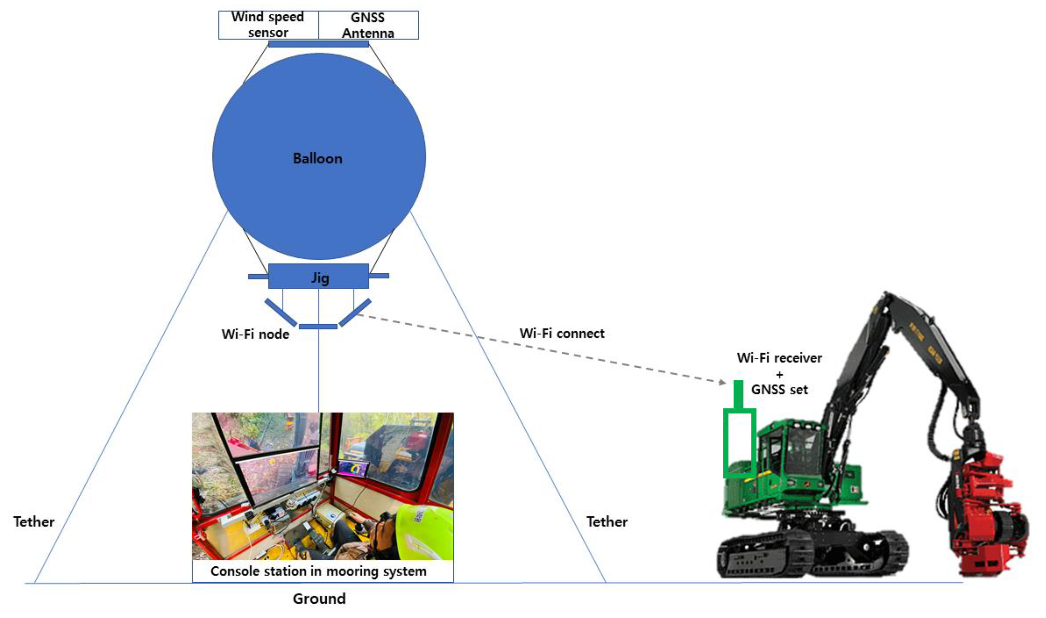
2.1. Wi-Fi System with a Tethered Balloon

We built a system equipped with a jig for measurements, such as Wi-Fi nodes, a wind-speed sensor, and a GNSS antenna attached to the helium balloon. The GNSS used has a position accuracy with an error of 0.01 m and offers various interfaces for data logging, such as UART, USB, SPI, and I2C. Additionally, the GNSS signals combined with RTK technology provide fast convergence times and reliable performance, making it ideal for highly dynamic applications such as UAVs.

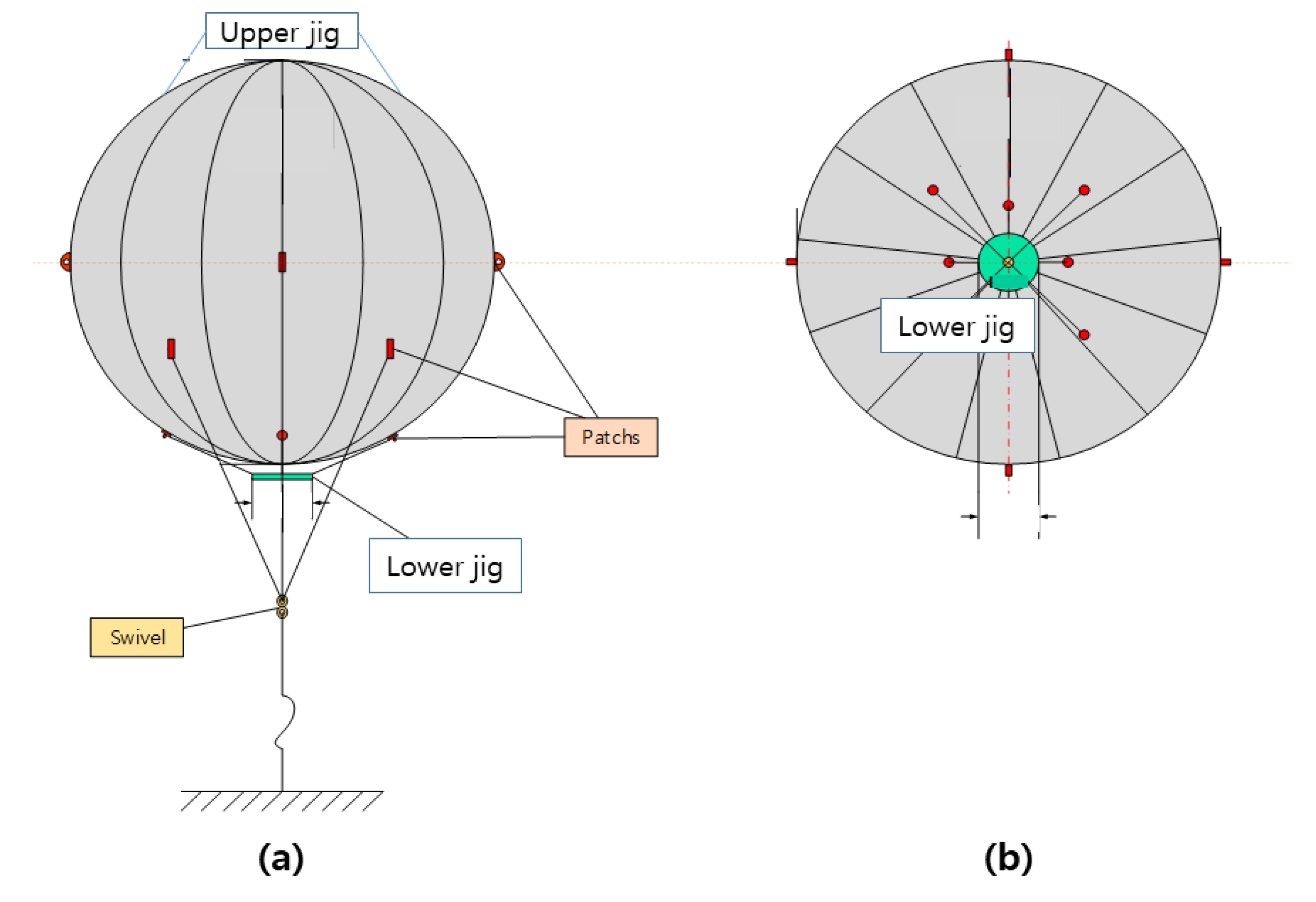
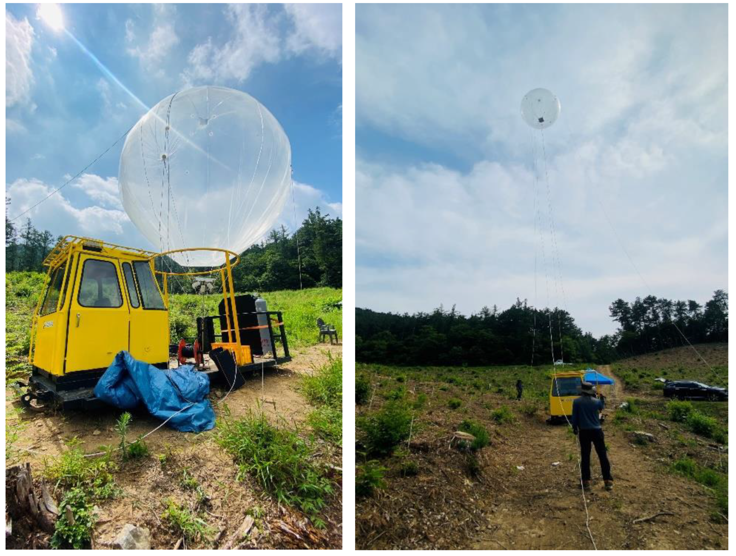
2.1.1. Helium Balloon

We designed a helium balloon capable of supporting the weight of the jig for measurement and the Wi-Fi node. Teflon polyurethane was utilized as the material because it is highly resistant to external shocks and scratches. The jigs were attached to the bottom and top parts of the helium balloon. While a GNSS antenna and wind-speed sensors were placed in the upper jig, the jig used for measurements was placed at the bottom part of the balloon. Table 2 and Figure 2 indicate the design specifications of the helium balloon.

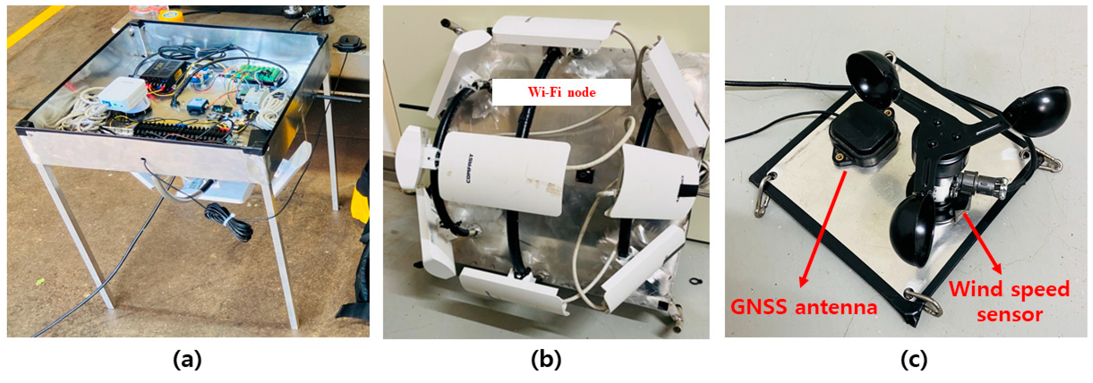
2.1.2. Measurement System and Jig

Figure 3 shows the measurement system mounted on the helium balloon. The inertial measurement unit (IMU, WT61C TTL AHRS, Wit motion, Shenzhen, China) was attached to measure the attitude of the helium balloon. The GNSS module (ZED-F9P, u-blox, Zurich, Switzerland) processes the signal from the GNSS antenna shown in Figure 3c, obtaining the latitude and longitude of the helium balloon. Additionally, the GNSS data error was minimized by facilitating the real-time kinematic (RTK) function. A temperature and humidity sensor (NHT-RS232, SHIBA KOREA, Anyang, Republic of Korea), a wind-speed sensor (JL-FS2, DFROBOT, Shanghai, China), and an altitude sensor (BMP280, Wit motion, China) were installed to identify the environmental conditions at the time of the test. The data logger was developed by Arduino; all the data related to IMU, temperature and humidity, GNSS, wind speed, and altitude were received and handled. The format of the received data was converted to time series data. The data were transmitted to telemetry once a second through a universal asynchronous receiver/transmitter (UART) communication device. These functions were all implemented through programming, and Figure 4 presents the data acquisition logic of the developed data logger. Finally, telemetry transmitted the data to the laptop wirelessly using radio frequencies. A jig was required for mounting the measurement systems on the helium balloon. Figure 3a indicates the completed jig. The jig was designed to mount measurement systems and Wi-Fi nodes. Aluminum was selected as its material by taking into account the loading weight of the helium balloon.

2.1.3. Wi-Fi Nodes

The CF-E120A model from COMFAST was utilized as the Wi-Fi node, as shown in Figure 3b. Its output power is 23 dBm (200 mW), and its bandwidth is 5.8 GHz. Wi-Fi can operate on both the 2.4 GHz and 5.8 GHz bands. The 5.8 GHz band is capable of transmitting higher resolution video compared to the 2.4 GHz band. While the 2.4 GHz band can transmit up to HD resolution, the 5.8 GHz band can transmit up to full HD resolution [12,29]. Therefore, in this study, we utilized Wi-Fi nodes operating on the 5.8 GHz band. Additionally, to compensate for the limited coverage compared to the 2.4 GHz band, multiple Wi-Fi nodes were connected to build the system (Figure 3b). The antenna of the Wi-Fi node is directional with a beam angle of 60°. When utilizing multiple Wi-Fi nodes, we set all the Wi-Fi nodes to have different internet protocol addresses. We also set the gateway to have the same addresses. The service set identifier (SSID) of each Wi-Fi node was set to be the same. The bridge mode provided by CF-E120A allows multiple Wi-Fi nodes to provide the same SSID. Nine Wi-Fi nodes were utilized for the developed system.

2.1.4. Mobile Mooring Station

A mobile mooring station was constructed to operate the Wi-Fi system with a tethered balloon. The system in this study was applied to the wood harvesting field in the Republic of Korea and was implemented as a mobile type for movement convenience. The mobile mooring station consisted of a helium gas reservoir/tank, a helium balloon holder, an alternating current (AC) power supply winch to power a measurement system included in the jig and the Wi-Fi node, and the main tether winch to adjust the height of the helium balloon. As the helium balloon goes upward in the air, the AC power and the main tether lines follow. Figure 5 presents the completed mobile mooring station.

2.2. Wi-Fi RSSI Measurement System

2.2.1. Wi-Fi Receiver

AWK-4131A from MOXA was utilized to measure the RSSI of the Wi-Fi system with the tethered balloon developed in this study. It was equipped with a 2 × 2 multiple-input-multiple-output antenna and had a wireless local area network standard of 802.11a/b/g/n. It also provided the access point (AP), bridge, and client modes. In this study, we utilized the client mode in the 5.8 GHz band. The client mode can serve as a receiver, and it can connect to the SSID of the Wi-Fi node for communication execution. It also has the Turbo roaming function. Turbo roaming is applied to Wi-Fi nodes that provide the same SSID. It automatically connects to the SSID of a Wi-Fi node with a stronger RSSI. In this study, we employed multiple Wi-Fi nodes; accordingly, the Turbo roaming function of the receiver was used.

2.2.2. GNSS Set

The coordinates of the Wi-Fi receiver are required to measure the communication range via the RSSI. We utilized the R10 system from Trimble to obtain the coordinate information. This system consists of a GNSS antenna and a cell phone module (TDC100, Trimble, Westminster, CA, USA). It has the RTK function. Accordingly, it is possible to measure the coordinate errors within approximately 2.9 cm [32]. The survey application Smart Topo 2018 was utilized as a cellphone module. The application was produced on the Android platform and enabled the collection of real-time latitude and longitude data. These data were transferred to a laptop in the form of coordinate acquisition time, latitude, and longitude.

2.2.3. Data Acquisition and Analysis

All the data were stored on a laptop computer. The data transmitted from the Wi-Fi system with the tethered balloon were collected by the PLX-DAQ program (version 2.9, PARALLAX, Rocklin, CA, USA). The latitude and longitude data from the Wi-Fi RSSI measurement system were transmitted to the laptop through the R10 cell phone module. The RSSI data were collected by the Turbo loaming analyzer (version 2.0, MOXA, New Taipei city, Taiwan). The collected RSSI data were analyzed through the open-source network packet analysis program Wireshark (version 4.0.6). The elevation data for the calculation of the LOS distance were analyzed by Pix4Dmapper (version 4.5.6, Pix4D, Prilly, Switzerland) and ArcGIS (version 10.8.1, ESRI, Redlands, CA, USA). We also created a digital terrain model (DTM) using Pix4Dmapper by using photos of the study site obtained by a drone (Mavic2 Pro, DJI, Shenzhen, China). We then analyzed the elevation data with the use of the DTM, and the latitude and longitude of human movement in ArcGIS. Figure 6 shows the entire flowchart of the data collection and analysis.

2.3. System Performance Evaluation
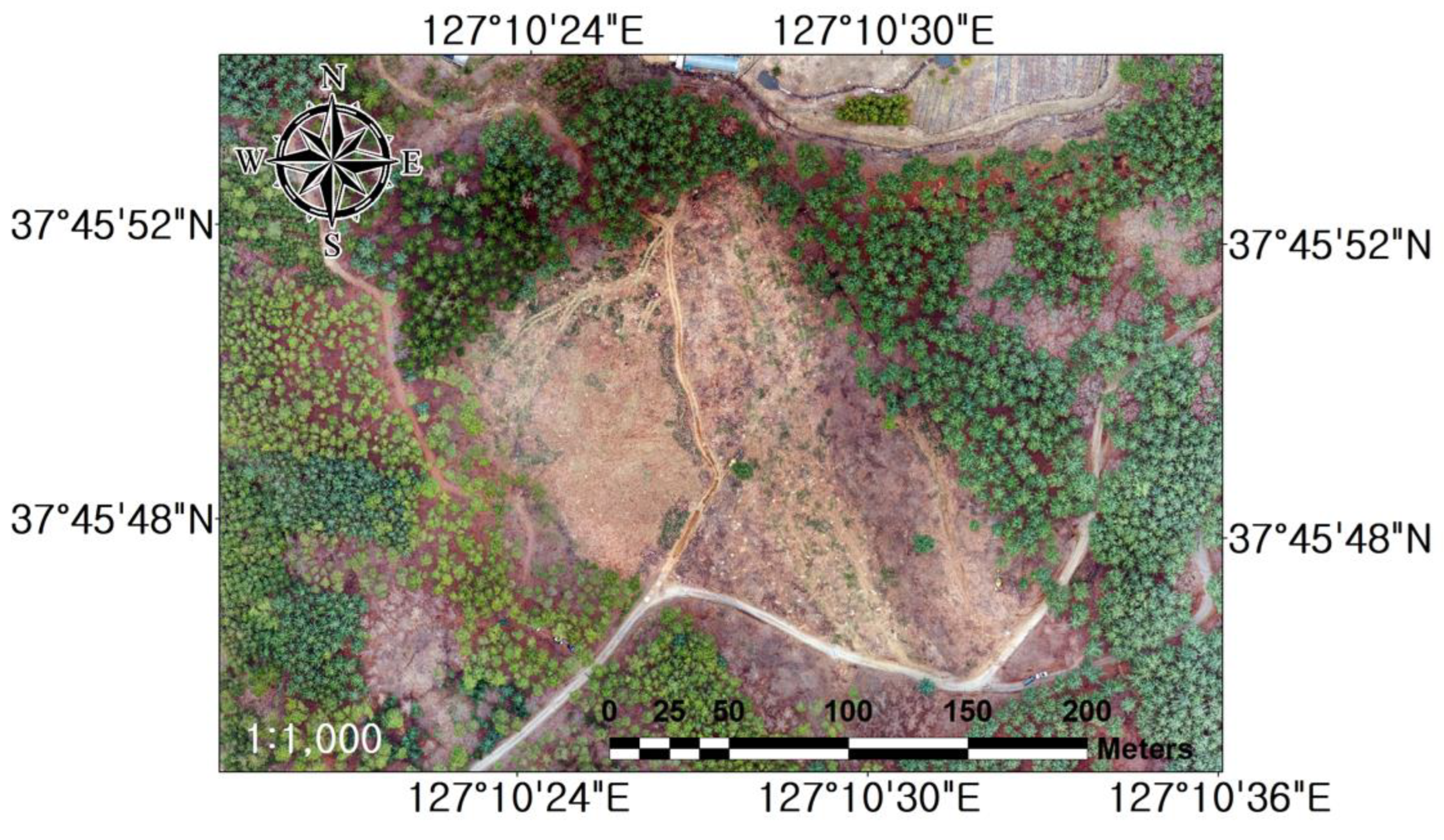
2.3.1. Study Site

This study was conducted in 16compartment (37°45′48.9″ N 127°10′27.8″ E) in the Gwangneung Experimental Forest located in Jikdong-ri, Sohil-eup, Pocheon City, Gyeonggi Province, the Republic of Korea. The study site was an open area with a gentle slope, featuring 60% vegetation density and trees of age class 4 or higher that had reached the stage for timber harvesting.
This system was developed for the teleoperation of vehicular forestry machines. The forestry forwarder is a machine capable of the yarding and transportation of logs after clear-cutting. Thus, we selected the following study site by assuming the situation after clear-cutting. Figure 7 presents the current status of the study site.

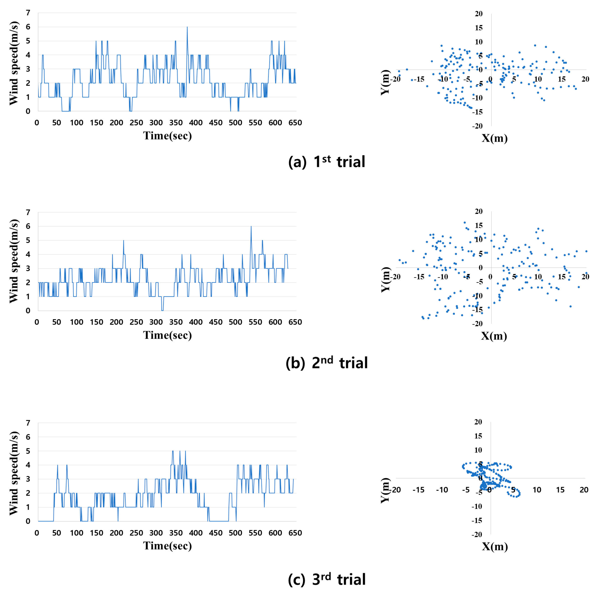
2.3.2. Meteorological Condition

The Wi-Fi system with a tethered balloon on the mobile mooring station swayed because of the wind; Figure 8 shows the wind speed and the coordinates at which the helium balloon traveled. The average wind speed was measured to be 2.1 m/s in Figure 8a, 2.2 m/s in Figure 8b, and 1.7 m/s in Figure 8c. As shown in Figure 8, the helium balloon moved in a random direction. Figure 9 indicates the roll, pitch, and yaw of the helium balloon and the height change of the floating helium balloon. As shown in Figure 9a–c, the helium balloon was tilted or rotated. The height of the floating helium balloon was also altered randomly.

2.3.3. RSSI Measurement of the Wi-Fi System

The RSSI is an indicator of the strength of the received Wi-Fi signal, and the Wi-Fi connection becomes unstable when the strength is weaker. Thus, we measured the RSSI of the developed system to identify the range of the stable Wi-Fi zone. While the balloon was floating in the air, the person who carried the Wi-Fi RSSI measurement system (in the form of a bag) walked toward eight directions while looking at the study site map stored in the R10 mobile phone module in advance. The RSSI was measured with its current position data, such as latitude and longitude, in real-time. Since there were several inaccessible areas to walk through, we attempted to collect as many data items as possible at locations at which the person could move easily. The test was performed repeatedly three times (Figure 10).

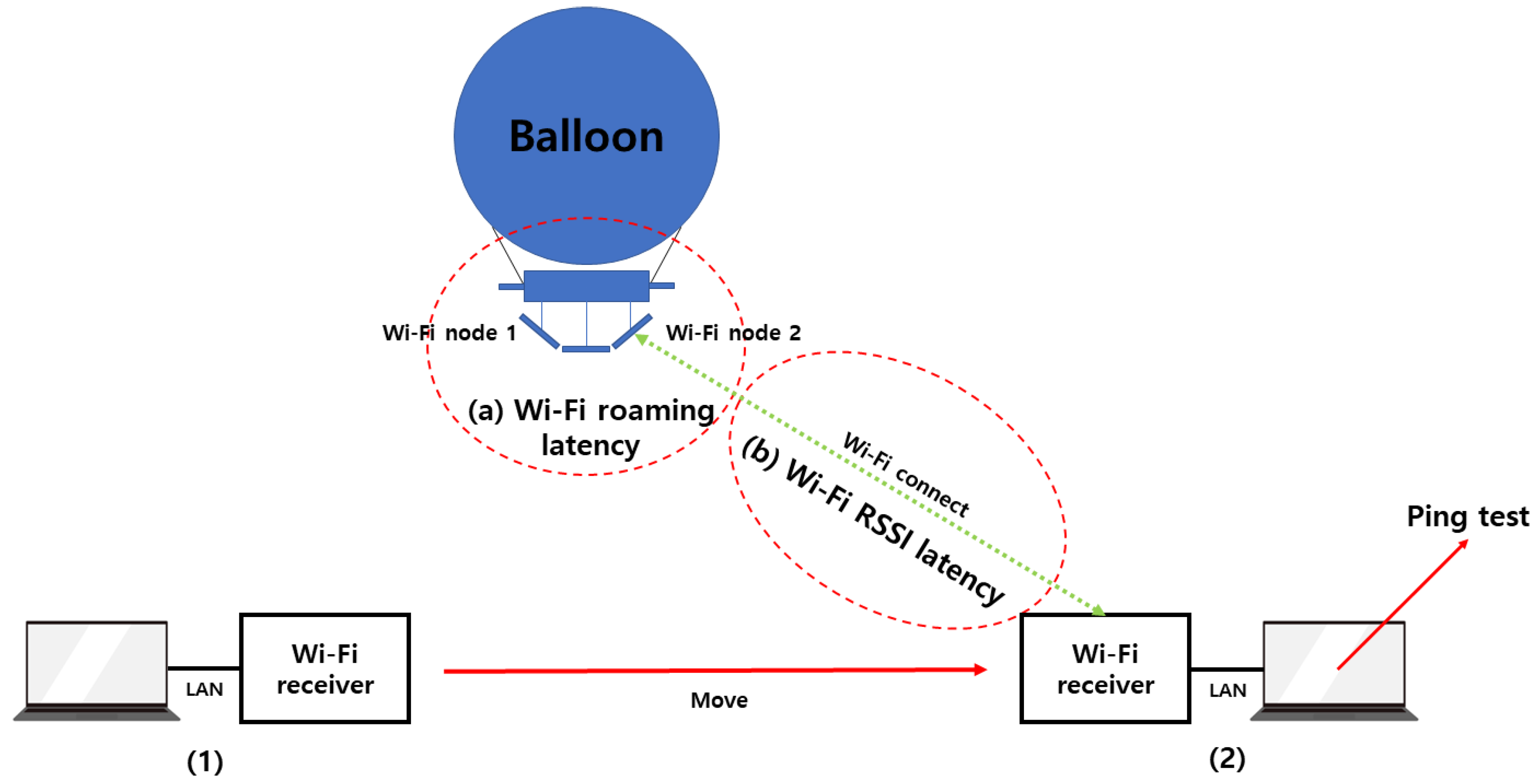
2.3.4. Latency Measurement of the Wi-Fi System

Figure 11 shows a schematic depicting the latency of the Wi-Fi system with a tethered balloon. The Wi-Fi latency in this system is composed of Wi-Fi roaming latency and Wi-Fi RSSI latency. The former is the latency occurring during Wi-Fi roaming, and the latter is the latency incurred when the data are transmitted and received via Wi-Fi. The Wi-Fi roaming latency was measured using a Turbo roaming analyzer by calculating the difference in time between the signal disconnection and reconnection. Additionally, the Wi-Fi node that is connected to the receiver during roaming can be monitored in real time through the media access control (MAC) address of the AP. The Wi-Fi RSSI latency was measured through the packet internet groper (Ping) service after the Wi-Fi receiver was moved to a location corresponding to the measurable RSSI and connected to a laptop personal computer. Ping is a method used to measure the latency incurred from an internet network [33]. The ping test was conducted using the open-source program Hrping (version 5.0.7), where a packet of 9 Mbps of data was used.

3. Results and Discussions
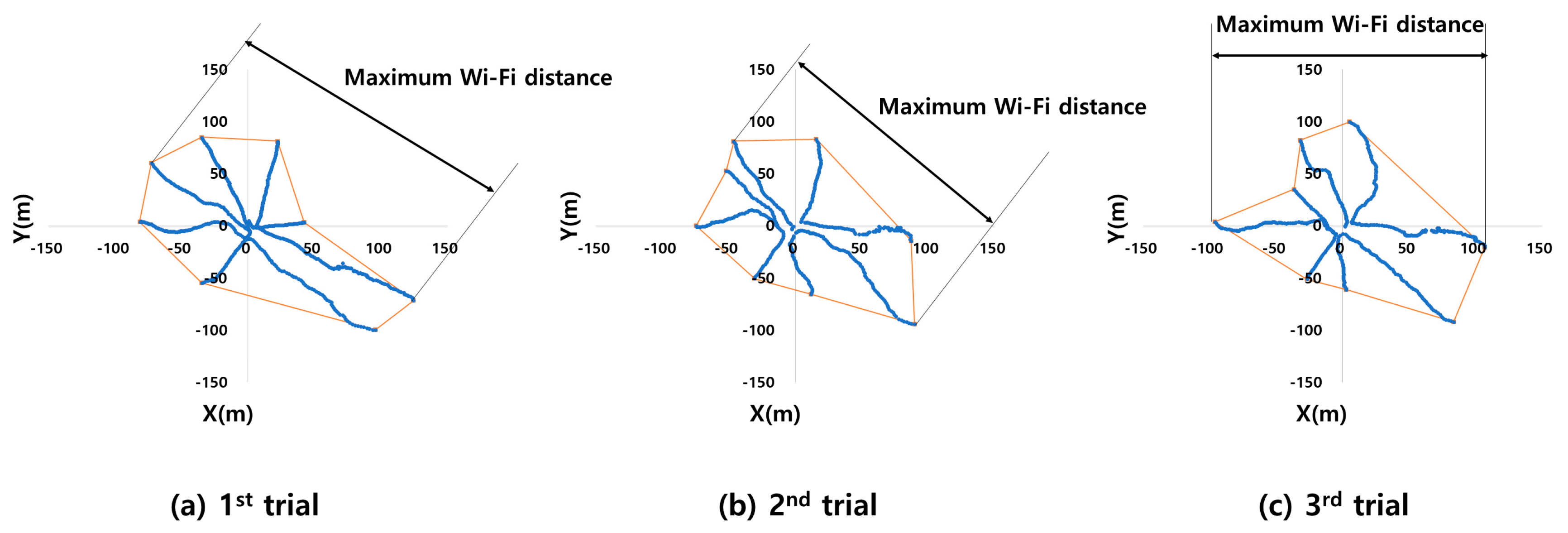
3.1. Wi-Fi Coverage

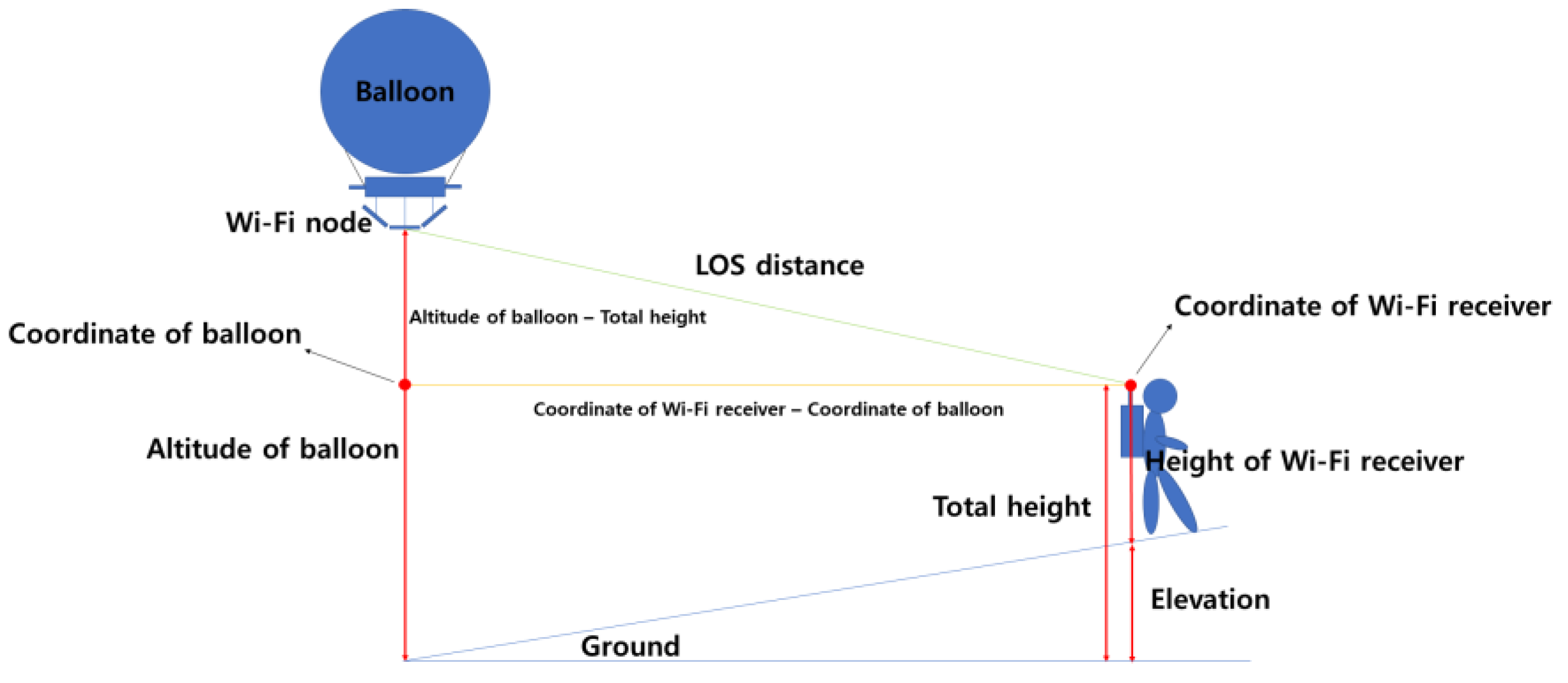
3.1.1. Wi-Fi RSSI for LOS Distance

It was reasonable that the Wi-Fi RSSI data were presented based on the LOS distance instead of the local coordinates on the ground. Figure 12 is a schematic used to calculate the LOS distance for the Wi-Fi RSSI. The geographical coordinates of the helium balloon and Wi-Fi receiver were converted to planar coordinates. The total height was determined by summing the elevation and the height of the Wi-Fi receiver. The LOS distance was finally calculated using the altitude and total height based on the Pythagorean theorem (Equation (1)). The RSSI for the LOS distance for all the measurement points on the ground coordinates were converted based on the LOS distance as the person moved. The maximum LOS distances for three trials were 162.91 m, 141.21 m, and 139.89 m, respectively. In all three results, the RSSI were measured to range between −69 dBm and −45 dBm.
Figure 12. Schematic diagram of LOS distance calculation method.
Forests 15 01994 g012
L O S   d i s t a n c e = C r C b 2 + ( A b T h ) 2
where
C b = the planar coordinates (X, Y) of the balloon;
C r = the planar coordinates (X, Y) of the Wi-Fi receiver;
Ab = the altitude of the balloon (m);
Th = the total height (m).

3.1.2. Wi-Fi Coverage Measurement

Figure 13a–c show the results associated with the conversion of the traveled paths for the RSSI measurement to the planar coordinates. The blue lines represent the coordinates for the traveled path, and the endpoints of the moved coordinates are connected with a red line to visualize the area. We calculated the maximum communication range by using the two farthest points. The maximum communication ranges of Figure 13a–c based on the straight line distance were 237.71 m, 222.16 m, and 204.55 m, respectively. As a result of analyzing the visualized area via ArcGIS, Figure 13a–c have areas equal to 1.9 ha, 1.8 ha, and 1.9 ha, respectively. Wi-Fi communication was available at all the coordinates of a sensor-carrying person, who moved in eight directions. While the Wi-Fi system with a tethered balloon was floating 60 m in the air, the maximum LOS distance for the Wi-Fi communication was measured to be 162.91 m. As shown in Figure 14, it is theoretically possible to calculate the area of the Wi-Fi zone by using the LOS distance and the height of the balloon, which was calculated to be approximately 7.2 ha. Therefore, since the areas in Figure 13a–c are included in the theoretically calculated Wi-Fi zone, it is concluded that Wi-Fi communication was possible at all the coordinates where the person moved. It is also expected that a larger area than the maximum 1.9 ha in the test data could be covered.

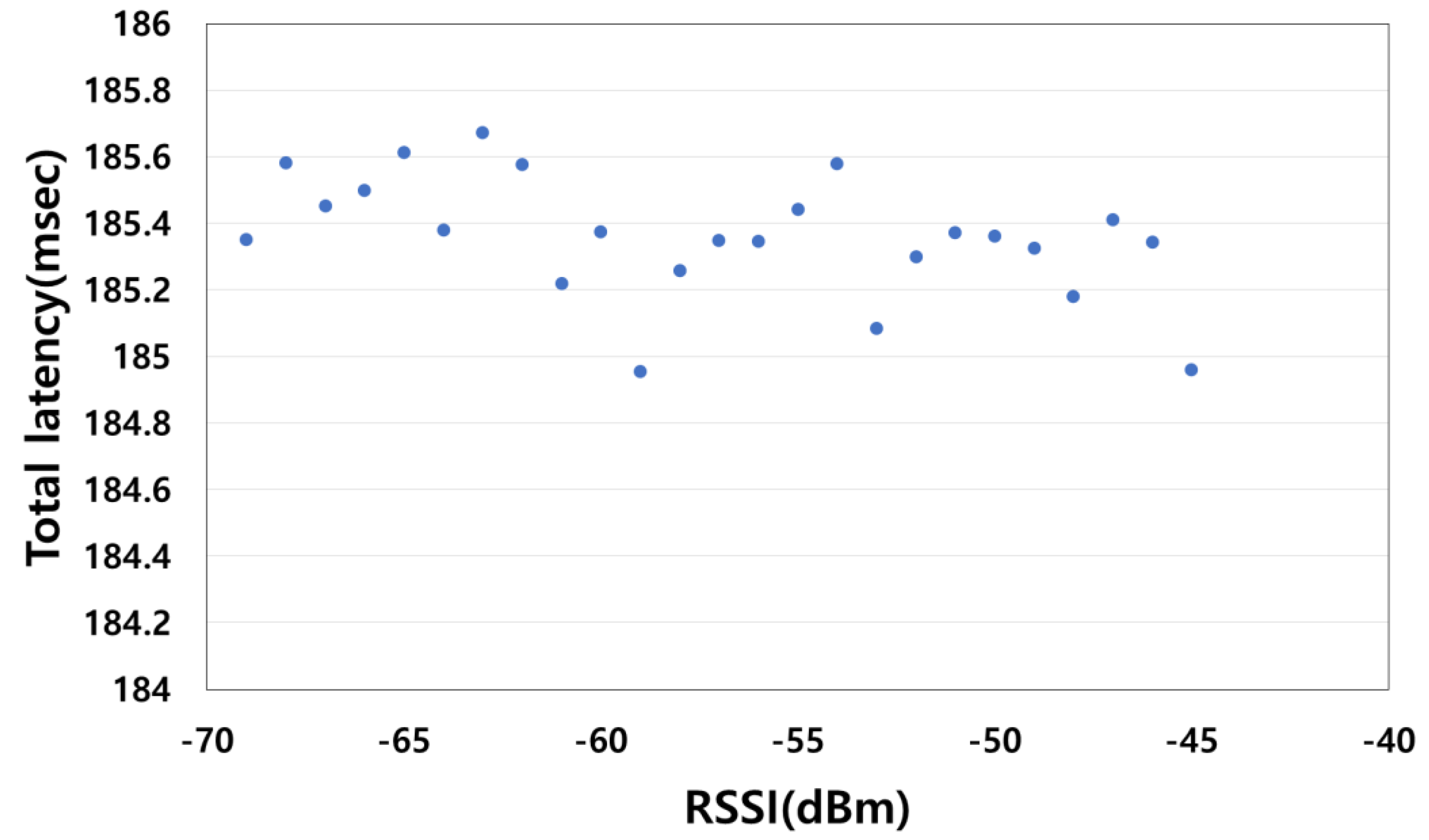
3.2. Total Latency of the Developed System

Within the RSSI range measured, the total latency of the developed Wi-Fi system with a tethered balloon was calculated by summing up the latency generated from the Wi-Fi roaming and the Wi-Fi RSSI latency. In addition, another latency was incurred when the image was encoded and decoded in the camera and the monitor, respectively. It should not be excluded. Kim et al. [12] found that the latency relevant to the image transmission was 123.086 ms. When performing the teleoperation through the developed system, it is possible to calculate the total latency corresponding to each RSSI, as shown in Figure 15. The maximum total latency for each RSSI was measured to be 185.7 ms. Brunnström et al. [34] found that operators complained about inconvenience when a latency of >200 ms occurred when teleoperation was performed with a vehicular forestry machine. The maximum total latency measured in this study was 185.7 ms. Thus, it is judged that the operators can perform the teleoperation using the developed system.

4. Conclusions

We developed a Wi-Fi system with a tethered balloon for the teleoperation of a vehicular forestry machine. We also evaluated the performance of this system by measuring the total latency for the LOS distance and the range of the Wi-Fi zone created by the developed system. This system is deemed to be operable in an open area without steep slopes when the average wind speed is 2.2 m/s or less on a clear day suitable for timber harvesting. Additionally, it is possible to perform stable Wi-Fi communication up to 162.91 m based on the LOS distance within an area of a maximum of 1.9 ha, and the maximum range of communication capability was measured to be 237.71 m based on a straight line distance. Furthermore, we found that the developed system can perform stable Wi-Fi communications in omni-directions, not just in a straight line.
In the future, it is needed to investigate the adverse effect of dense canopy, which may block the LOS between the Wi-Fi node on the balloon and the forest machine. Additionally, we will conduct research to examine compatibility with Starlink satellites. Recent studies utilizing Starlink and Wi-Fi have confirmed the performance of broadband internet networks and configuring applications [35]. The system developed in this study is also a system that utilizes Wi-Fi. If the developed system is connected to Starlink and utilized, it is expected to be able to build broadband internet networks, even in forest areas with weak signals. Determining whether this wireless communication coverage allows operators to effectively perform the teleoperation of forestry machines could also become an important task.

Author Contributions

Conceptualization, J.-H.O. and G.-H.K.; methodology, G.-H.K.; software, G.-H.K.; validation, B.-S.S. and H.-S.L.; investigation, G.-H.K. and H.-S.L.; resources, G.-H.K. and H.-S.M.; data curation, G.-H.K.; writing original draft preparation, G.-H.K.; writing—review and editing, J.-H.O. and B.-S.S.; visualization, H.-S.L. All authors have read and agreed to the published version of the manuscript.

Funding

This study was conducted with the support of the R&D Program for Forest Science Technology [grant number 2023475A00-2325-BB01] provided by the Korea Forest Service (Korea Forestry Promotion Institute).

Data Availability Statement

Please contact the corresponding author for data requests.

Conflicts of Interest

The authors declare no conflicts of interest.

References

  1. Cho, M.-J.; Choi, Y.-S.; Mun, H.-S.; Lee, E.-J.; Eun-Jai, L.; Jung, E.-J.; Oh, J.-H.; Han, S.-K.; Kim, D.-H.; Cha, D.-S. Productivity and Costs of Felling Operation for Three Harvesting Methods in Mixed Forest Stands. J. Korean For. Soc. 2016, 105, 441–448. [Google Scholar] [CrossRef]
  2. Choi, Y.-S.; Cho, M.-J.; Mun, H.-S.; Kim, D.-H.; Cha, D.-S.; Han, S.-K.; Oh, J.-H. Analysis on Yarding Productivity and Cost of Tower-Yarder Based on Excavator Using Radio-Controlled Double Clamp Carriage. J. Korean Soc. For. Sci. 2018, 107, 266–277. [Google Scholar] [CrossRef]
  3. Maciak, A.; Kubuska, M.; Moskalik, T. Instantaneous Cutting Force Variability in Chainsaws. Forests 2018, 9, 660. [Google Scholar] [CrossRef]
  4. Choi, Y.-S.; Cho, M.-J.; Mun, H.-S.; Oh, J.-H. Productivity and Cost of Mechanized Felling and Processing Operations Performed with an Excavator-Based Stroke Harvester by Tree Species. J. Korean Soc. For. Sci. 2022, 111, 567–582. [Google Scholar] [CrossRef]
  5. Cadei, A.; Mologni, O.; Röser, D.; Cavalli, R.; Grigolato, S. Forwarder Productivity in Salvage Logging Operations in Difficult Terrain. Forests 2020, 11, 341. [Google Scholar] [CrossRef]
  6. Palmén, M. Nonlinear Model Predictive Control in Path Tracking and Rollover Prevention for Autonomous Forest Machines. Master’s Thesis, Aalto University, Espoo, Finland, 2023. [Google Scholar]
  7. Lee, J.-S.; Kim, B.-E.; Sun, D.-I.; Han, C.-S.; Ahn, Y.-H. Development of Unmanned Excavator Vehicle System for Performing Dangerous Construction Work. Sensors 2019, 19, 4853. [Google Scholar] [CrossRef] [PubMed]
  8. Jeong, Y.-M.; Yang, S.-Y. Development Trend of Remote Control Technology of Construction Machinery. J. Drive Control 2015, 12, 34–38. [Google Scholar]
  9. Cui, J.; Tosunoglu, S.; Roberts, R.; Moore, C.; Repperger, D.W. A Review Of Teleoperation System Control. In Proceedings of the Florida Conference on Recent Advances in Robotics, FCRAR, Boca Raton, FL, USA, 8–9 May 2003. [Google Scholar]
  10. Westerberg, S.; Manchester, I.R.; Mettin, U.; Hera, P.L.; Shiriaev, A. Virtual Environment Teleoperation of a Hydraulic Forestry Crane. In Proceedings of the 2008 IEEE International Conference on Robotics and Automation, Pasadena, CA, USA, 19–23 May 2008; IEEE: Piscataway, NJ, USA, 2008. ISBN 9781424416479. [Google Scholar]
  11. Milne, B.; Chen, X.; Hann, C.; Richard, P. Robotisation of Forestry Harvesting in New Zealand-An Overview. In Proceedings of the 2013 10th IEEE International Conference on Control and Automation (ICCA), Hangzhou, China, 12–14 June 2013; IEEE: Piscataway, NJ, USA, 2013. ISBN 9781467347082. [Google Scholar]
  12. Kim, G.-H.; Kim, K.-D.; Lee, H.-S.; Choi, Y.-S.; Mun, H.-S.; Oh, J.-H.; Shin, B.-S. Development of Wi-Fi-Based Teleoperation System for Forest Harvester. J. Biosyst. Eng. 2021, 46, 206–216. [Google Scholar] [CrossRef]
  13. Chopra, N.; Berestesky, P.; Spong, M.W. Bilateral Teleoperation over Unreliable Communication Networks. IEEE Trans. Control Syst. Technol. 2008, 16, 304–313. [Google Scholar] [CrossRef]
  14. Hakim, G.P.N.; Habaebi, M.H.; Toha, S.F.; Islam, M.R.; Yusoff, S.H.B.; Adesta, E.Y.T.; Anzum, R. Near Ground Pathloss Propagation Model Using Adaptive Neuro Fuzzy Inference System for Wireless Sensor Network Communication in Forest, Jungle and Open Dirt Road Environments. Sensors 2022, 22, 3267. [Google Scholar] [CrossRef]
  15. Singh, Y. Comparison of Okumura, Hata and COST-231 Models on the Basis of Path Loss and Signal Strength. Int. J. Comput. Appl. 2012, 59, 975–8887. [Google Scholar] [CrossRef]
  16. Yun, Z.; Omaki, N.; Iskander, M.F. Ridge Feature Extraction and Effect on Radio Propagation for Wireless Communications. In Proceedings of the 2012 IEEE International Symposium on Antennas and Propagation, Chicago, IL, USA, 8–14 July 2012; IEEE: Piscataway, NJ, USA, 2012. ISBN 9781467304627. [Google Scholar]
  17. Wang, Q.; Li, W.; Yu, Z.; Abbasi, Q.; Imran, M.; Ansari, S.; Sambo, Y.; Wu, L.; Li, Q.; Zhu, T. An Overview of Emergency Communication Networks. Remote Sens. 2023, 15, 1595. [Google Scholar] [CrossRef]
  18. Son, S.-H.; Gang, J.-H.; Park, G.-J. Overview and Issues of Drone Wireless Communication. Inf. Commun. Mag. 2016, 33, 93–99. [Google Scholar]
  19. Bilaye, P.; Gawande, V.N.; Desai, U.B.; Raina, A.A.; Pant, R.S. Low Cost Wireless Internet Access for Rural Areas Using Tethered Aerostats. In Proceedings of the 2008 IEEE Region 10 and the Third international Conference on Industrial and Information Systems, Kharagpur, India, 8–10 December 2008; IEEE: Piscataway, NJ, USA, 2008. [Google Scholar]
  20. Hartley, R.J.a.L.; Henderson, I.L.; Chris Lewis, J. BVLOS Unmanned Aircraft Operations in Forest Environments. Drones 2022, 6, 167. [Google Scholar] [CrossRef]
  21. Alzidaneen, A.; Alsharoa, A.; Alouini, M.-S. Resource and Placement Optimization for Multiple UAVs Using Backhaul Tethered Balloons. IEEE Wirel. Commun. Lett. 2020, 9, 543–547. [Google Scholar] [CrossRef]
  22. Zhang, S.; Liu, W.; Ansari, N. On Tethered UAV-Assisted Heterogeneous Network. IEEE Trans. Veh. Technol. 2022, 71, 975–983. [Google Scholar] [CrossRef]
  23. Belmekki, B.E.Y.; Alouini, M.-S. Unleashing the Potential of Networked Tethered Flying Platforms: Prospects, Challenges, and Applications. IEEE Open J. Veh. Technol. 2022, 3, 278–320. [Google Scholar] [CrossRef]
  24. Cho, M.-J.; Choi, Y.-S.; Mun, H.-S.; Oh, J.-H. Comparison of the Timber Harvesting Productivity and Cost of Single-Operation Using a Forestry Combi-Machine Versus Multi-Operation Using a Tower-Yarder and Processor. J. Korean Soc. For. Sci. 2022, 111, 583–593. [Google Scholar] [CrossRef]
  25. Qiantori, A.; Sutiono, A.B.; Hariyanto, H.; Suwa, H.; Ohta, T. An Emergency Medical Communications System by Low Altitude Platform at the Early Stages of a Natural Disaster in Indonesia. J. Med. Syst. 2010, 36, 41–52. [Google Scholar] [CrossRef]
  26. Alsamhi, S.H.; Almalki, F.A.; Ma, O.; Ansari, M.S.; Angelides, M.C. Performance Optimization of Tethered Balloon Technology for Public Safety and Emergency Communications. Telecommun. Syst. 2020, 75, 235–244. [Google Scholar] [CrossRef]
  27. Park, E.; Lee, M.S.; Kim, H.S.; Bahk, S. AdaptaBLE: Adaptive Control of Data Rate, Transmission Power, and Connection Interval in Bluetooth Low Energy. Comput. Netw. 2020, 181, 107520. [Google Scholar] [CrossRef]
  28. Pauca, O.; Lazar, R.G.; Postolache, M.; Caruntu, C.F. DMPC-Based Control Solution for Mobile Robots Platoon Based on ZigBee Communication. Comput. Electr. Eng. 2024, 120, 109755. [Google Scholar] [CrossRef]
  29. Kaur, G.; Balyan, V.; Gupta, S.H. Experimental Analysis of Low-Duty Cycle Campus Deployed IoT Network Using LoRa Technology. Results Eng. 2024, 23, 102844. [Google Scholar] [CrossRef]
  30. Akhter, Z.; Bilal, R.M.; Telegenov, K.; Feron, E.; Shamim, A. Indigenously Developed HD Video Transmission System for UAVs Employing a 3 × 3 MIMO Antenna System. IEEE Open J. Antennas Propag. 2022, 3, 940–947. [Google Scholar] [CrossRef]
  31. Wu, D.; Negi, R. Effective Capacity: A Wireless Link Model for Support of Quality of Service. IEEE Trans. Wirel. Commun. 2003, 2, 630–643. [Google Scholar] [CrossRef]
  32. Heikkilä, R.; Vermeer, M.; Makkonen, T.; Tyni, P.; Mikkonen, M. Accuracy Assessment for 5 Commercial RTK-GNSS Systems Using a New Roadlaying Automation Test Center Calibration Track. In Proceedings of the ISARC 2016—33rd International Symposium on Automation and Robotics in Construction, Auburn, AL, USA, 18–21 July 2016; International Association for Automation and Robotics in Construction (IAARC): Eindhoven, The Netherlands, 2016; pp. 812–817. [Google Scholar]
  33. Rajankumar, P.; Nimisha, P.; Kamboj, P. A Comparative Study and Simulation of AODV MANET Routing Protocol in NS2 & NS3. In Proceedings of the 2014 International Conference on Computing for Sustainable Global Development (INDIACom), New Delhi, India, 5–7 March 2014; IEEE: Piscataway, NJ, USA, 2014. ISBN 9789380544120. [Google Scholar]
  34. Brunnström, K.; Dima, E.; Andersson, M.; Sjöström, M.; Qureshi, T.; Johanson, M. Quality of Experience of Hand Controller Latency in a Virtual Reality Simulator. Electron. Imaging 2019, 31, art00012. [Google Scholar] [CrossRef]
  35. Ma, S.; Chou, Y.C.; Zhao, H.; Chen, L.; Ma, X.; Liu, J. Network Characteristics of LEO Satellite Constellations: A Starlink-Based Measurement from End Users. In Proceedings of the IEEE INFOCOM 2023-IEEE Conference on Computer Communications, New York, NY, USA, 17–20 May 2023; IEEE: Piscataway, NJ, USA, 2023; pp. 1–10. [Google Scholar]
Figure 1. Concept of forest machine teleoperation using Wi-Fi on tethered balloon.
Forests 15 01994 g001
Figure 2. Overview of helium balloon: (a) front and (b) bottom views.
Forests 15 01994 g002
Figure 3. Real view of (a) lower jig, (b) Wi-Fi nodes under lower jig, and (c) upper jig.
Forests 15 01994 g003
Figure 4. Data acquisition logic of the developed data logger.
Forests 15 01994 g004
Figure 5. Developed mobile mooring and console station.
Forests 15 01994 g005
Figure 6. Data collection and analysis.
Forests 15 01994 g006
Figure 7. Study site.
Forests 15 01994 g007
Figure 8. Wind velocity (left) and coordinates of the helium balloon moved by the wind (right).
Forests 15 01994 g008
Figure 9. Changes in roll, pitch, and yaw according to altitude of the tethered balloon.
Forests 15 01994 g009
Figure 10. Installation of the developed system.
Forests 15 01994 g010
Figure 11. Schematic of the latency occurring in the Wi-Fi system with a tethered balloon (Wi-Fi roaming occurs from Wi-Fi node (1) to Wi-Fi node (2) when Wi-Fi receiver on the machine Wi-Fi goes out of area covered by Wi-Fi node (1)).
Forests 15 01994 g011
Figure 13. Traveled path converted to planar coordinates.
Forests 15 01994 g013
Figure 14. Creation of the Wi-Fi zone for the developed system.
Forests 15 01994 g014
Figure 15. Overall latency for RSSI.
Forests 15 01994 g015
Table 1. The data rates for Bluetooth, Zigbee, LoRa, and Wi-Fi.
Wireless
Communication Type
Data Rate
Bluetooth2 Mbps
Zigbee250 Kbps
LoRa0.44 Kbps
Wi-Fi10 Mbps
Table 2. Specifications of helium balloon.
DiameterVolumeInstrument WeightLifting ForceMaterial
4.2 m38.77 m3130 N417 NTeflon polyurethane
Disclaimer/Publisher’s Note: The statements, opinions and data contained in all publications are solely those of the individual author(s) and contributor(s) and not of MDPI and/or the editor(s). MDPI and/or the editor(s) disclaim responsibility for any injury to people or property resulting from any ideas, methods, instructions or products referred to in the content.

