Article

Land Suitability Analysis for Forests in Lebanon as a Tool for Informing Reforestation under Climate Change Conditions

1
Department of Agricultural Sciences, University of Sassari, 07100 Sassari, Italy
2
Department of Environment and Natural Resources, Lebanese University, Beirut P.O. Box 6573/14, Lebanon
3
Impacts on Agriculture, Forestry and Ecosystem Services (IAFES) Division, Euro-Mediterranean Center on Climate Changes (CMCC), Via E. de Nicola 9, 07100 Sassari, Italy
4
National Council for Scientific Research, Beirut P.O. Box 11-8281, Lebanon
5
National Biodiversity Future Center (NBFC), Palazzo Steri, 90133 Palermo, Italy
*
Author to whom correspondence should be addressed.
Forests 2023, 14(9), 1893; https://doi.org/10.3390/f14091893
Submission received: 9 August 2023 / Revised: 13 September 2023 / Accepted: 14 September 2023 / Published: 17 September 2023
(This article belongs to the Section Forest Meteorology and Climate Change)

Abstract

:
Along with the concept of improving reforestation efforts in Lebanon, this study aimed to provide a land suitability analysis for forest species in Lebanon while considering the effect of climate change. Herein, the soil evaluation criteria developed by FAO (The Food and Agriculture Organization) for land suitability classification were implemented through the weighted overlay method to produce suitability maps based on natural variables (soil, climate, and topography) influencing the presence of the species on the land. Cedrus libani, Quercus calliprinos, Ceratonia siliqua, Eucalyptus globulus, and Pinus halepensis are the species considered in this study. The results of this study provide useful information to inform reforestation activities in Lebanon, considering the expected climate change projections for medium- (2050) and long-term (2070) periods, according to two different scenarios (RCP4.5 and RCP8.5) and three General Circulation Models: CCSM4, GFDL-CM3, and HadGEM2-ES. The suitability maps showed a generally critical situation for the spatial distribution of forest species under future climate change compared to the current situation (1970–2000). The distribution of thermophilic species, which tolerate high temperatures (over 20 °C), was projected to expand compared to the current situation. In contrast, the expansion of cold-adapted species may be limited by future climate change conditions. It is crucial to consider the expected effects of climate change to better select species for reforestation and, therefore, to maintain forest cover in Lebanon.

1. Introduction

1.1. Forests of Lebanon and Climate Change

Global warming is one of the most pressing environmental issues nowadays. The Mediterranean Region is among the most vulnerable regions to the effects of climate change [1]. An increase in temperature, more variable precipitation, and more frequent and intense extreme events are expected because of climate change, unless urgent and strong mitigation actions are implemented [2]. The Mediterranean forests, which cover about 9.4% of the total global forest area, constitute approximately 30% of the Mediterranean’s total land surface [3]. In Lebanon, located in the eastern part of the Mediterranean basin, forests extend over 136,900 ha, while other woodlands cover 106,000 ha, representing around 13% and 11% of the total surface of the country [4], respectively. They spread from the coastal zone to the adjacent mountains (1500–2000 m), where they grow optimally at about 1800 m of altitude [5]. Lebanon witnesses variability in altitude due to its rugged topography and exposition, defining a diversity of climatic conditions from a Mediterranean climate along the coast and the mid-altitude of the mountain ranges, to sub-alpine and mountain Mediterranean climate on the highest slopes, and to an arid and sub-desert climate in the northern plains. This geographic and climatic diversity is reflected through a set of ecological systems that vary significantly from one region to another, generating, over the entire country, a true biological hotspot. The location of Lebanon has given rise to unique biodiversity, with 9119 known species, almost evenly divided between fauna (4486 species) and flora (4633 species) [6].

1.2. Forest Species and Resilience

The most widespread Lebanese forest species are Quercus calliprinos, Quercus infectoria, Quercus cerris (mostly referred to as Quercus spp.), Juniperus excelsa, Cedrus libani, Abies cilicica, Pinus pinea, Pinus halepensis, Pinus brutia, and Cupressus sempervirens [5,7,8]. These forests are under serious threat due to wildfires, insects, diseases, urban growth, changes in land use, quarries, and war [9]. Many of these forests have been described as vulnerable to climate change due to a decline in the regeneration rate, with Juniperus excelsa categorized as very highly sensitive to climate change, followed by Cedrus libani, Abies cilicica, and Quercus cerris [8,10,11]. Additionally, Kelley et al. [10] declared that ecosystems and forests are already affected by climate change, especially considering that forest stands suffer from fragmentation, pest outbreaks, forest fires, and unsuitable practices that challenge their capacity to survive and develop. Consequently, climate change, stressed by anthropogenic interventions, may set the grounds for the emergence of unfavorable scenarios such as the diffusion of invasive alien species [12], which could eventually compromise the resilience of the existing forests, decrease their adaptation and survival chances, and reduce the areal extent of their natural habitat [11].
To protect the natural heritage of Lebanon’s forests and reduce the impact of climate change, Lebanon has signed more than 33 international conventions, including the Convention on Biological Diversity in 1992, ratified by the Ministry of Environment in 1994 [13]. In addition, interventions have been employed, notably through reforestation processes, including the program of planting 40 million trees on 70,000 ha of public lands, considered one of the main activities that support the proliferation of green areas in Lebanon. Ultimately, this program aims to increase Lebanon’s total forest cover from 13% to 20% in the coming 20 years [8]. Reforestation efforts have been encouraged by the government sector, and other entities have simultaneously been attempting to guide and facilitate these activities [8,14]. Nevertheless, the long-term recovery of forests should be supported by predicting changes in land suitability in the coming years.

1.3. Land Suitability and Forest Future

Over the last decades, there has been a growing demand for the development of decision-support tools for sustainable and spatialized land-use management with the support of GIS (Geographical Information System) technology [15,16,17]. These tools use suitability modeling methods relying on geo-information systems and satellite imagery, with the latter being more incorporated in the research fields of ecology, conservation, and management of tree species [18,19]. Several studies have been undertaken to assess land suitability worldwide using GIS and remote sensing [20,21,22,23,24,25,26,27,28,29,30]. Wandahwa et al. [21] used expert knowledge and spatialized data (climatic, soil, and landform requirements) in a GIS system to provide qualitative land suitability maps for generative Pyrethrum cultivation in Kenya. Mazahreh et al. [26] developed a GIS-based approach for land use suitability assessment in a semi-arid environment in Jordan to assist land managers in identifying areas with physical limitations for different land uses. They used FAO criteria and spatialized data (georeferenced raster) of soil depth, stone and rock percentages on the soil surface, and erosion type and status in a GIS model. Abdalah and Jaafar [27] provided spatial data on crop suitability for current and projected future conditions. The suitability maps were generated by combining the FAO EcoCrop model with monthly climatic datasets (spatialized data) from the WorldClim database. Results showed that many crops in the Levant would witness a decrease in their suitability, whereas the suitability of crops in the Upper Nile Basin would increase by 2050.
Previous research in Lebanon studied the effects of climate change on the growth rate of Cedrus libani, Abies cilicica, Juniperus drupacea, and Quercus spp. [9,31,32] and examined the best knowledge of tree species requirements for survival [18,33,34,35,36]. However, to our knowledge, there are no studies on the impact of climate change on forest land suitability for different forest species in Lebanon. Consequently, our initial hypothesis asserts that the expected climate changes could strongly modify the land suitability of Lebanon, thereby influencing the possibility for the growth of long-living species such as forest trees. This hypothesis will be thoroughly examined and discussed in this paper, with a particular emphasis on assessing the extent of climate impacts in terms of both suitability area reductions for some species and gains for others. Accordingly, the present study aimed to investigate this hypothesis by performing a holistic evaluation of the potential of Lebanon’s forest lands under present climate conditions and under climate projections for forest regeneration, including the introduction of pioneer species on degraded land, which have a pivotal role in increasing the forest cover to mitigate the negative effects of climate change. Land suitability maps of different suitability classes for each species under present and future climate conditions were obtained by combining the weighted overlay method (ArcGIS-based tool) and forest species requirements (FAO soil evaluation method for land suitability), in terms of soil and climate conditions. These results, representing the suitable conditions for five tree species (natives, potentials, and invasive) in Lebanon, can inform the reforestation process in Lebanon by serving as the basis for selective and precise reforestation activities at minimal cost. The results obtained can help forest planners to rehabilitate forests by planting suitable species in the appropriate locations, considering future climate change impacts on forests, thus allowing forest cover to expand while preserving species such as Cedrus from extinction.

2. Materials and Methods

2.1. Species Selection and Characteristics

This study focuses on Lebanon (Figure 1). The selection of the species analyzed in this study was made by considering their environmental and economic importance for Lebanon. Five species were selected following the research by Sattout and Zahreddine [5], which studied the characteristics of the native species in Lebanon and listed 69 trees and shrubs in Lebanon and its neighboring countries, although the list can be extended to almost 100 species [37]. The main characteristics of the selected species for this study are reported in Table 1.

2.2. Selected Data for Forest Land Suitability Analysis

2.2.1. Climate Data

The monthly average temperature and monthly average precipitation over the studied period were the climatic inputs for the land suitability forest models [38,39,40]. These data were obtained from the WorldClim database website in Geo-Tiff format with a resolution of 30 arc seconds (1 km × 1 km) (https://www.worldclim.org/data/index.html (1 January 2022)). For the suitability analysis under the current situation, historical climate data (average years 1979–2000) were used as the current/benchmark climate because the actual soil and forest conditions are determined by several decades of historical climate variations [38,41,42]. For the suitability analysis under future climate conditions (2050 and 2070), the climatic data were obtained via simulation with three General Circulation Models (CCSM4, GFDL-CM3, and HadGEM2-ES) (Table 2) [38,39,40]. All these climate projection models use the representative concentration pathway RCP8.5 and RCP4.5 scenarios for climate change from the Coupled Model Intercomparison Project Phase 5 (Table 2).

2.2.2. Soil and Geographic Data

Soil data for the year 2002 were obtained from the National Center of Remote Sensing in Lebanon (CNRS-L). The soil map, with a scale of 1:50,000, covers 27 layers and contains detailed information on the soil types in Lebanon, their locations, and morphology. The Digital Elevation Model (DEM) was created from the digital contour line map (1/20,000), which was adopted from the CNRS-L with a spatial resolution of 30 m × 30 m. Both maps were obtained with the same coordinate system (WGS_1984_UTM_Zone_36N), cell size (30 m × 30 m), and origin of the cells.

2.3. Suitability Classification Model Approach

Suitability refers to the fitness of a given type of soil to support the growth of a given tree species [38]. The land suitability classification process involves evaluating and grouping specific land areas according to their suitability for defined uses. Four classes of suitability were considered according to FAO 1976 [43]: highly suitable or optimal (S1), moderately suitable (S2), marginally suitable (S3), and not suitable (N). Table 3 describes the ranges of classification variables (altitude, temperature, annual precipitation) and soil types considered to define the suitability categories (S1, S2, S3, and N) for each forest species. These suitability categories are defined by FAO 1976 [43] as follows:
Highly suitable (S1): land with no significant limitations for a specified sustained use, and it is therefore expected to not reduce productivity or benefits or raise input requirements above an acceptable level;
Moderately suitable (S2): Land with limitations that are moderately severe for a specified sustained use. These limitations reduce productivity or benefits and increase required inputs, resulting in an overall advantage lower than that expected in class S1, although still attractive;
Marginally suitable (S3): Land with limitations that, in aggregate, are severe for sustained application of a given use. These limitations reduce productivity or benefits to the extent that the expenditure will be only marginally justified;
Unsuitable (N): land with limitations that severely preclude any possibility of successful sustained use.
To produce the suitability map (Figure 2), all classification variables presented in this study as raster images were first resampled to a spatial resolution of 30 m × 30 m (highest spatial resolution) and later aligned using the nearest neighbor function. This allowed the construction of a dataset cube, with each pixel of any classification variable having a spatially corresponding pixel for all other classification variables. The resampling and alignment of images were performed using the ArcGIS software.
The weighted overlay method was then used to produce the suitability maps. First, for each forest species, a suitability raster with values of S1, S2, S3, and N (coded as integers 1, 2, 3, and 4 for processing as a raster) was derived independently from each classification variable (altitude, temperature, annual precipitation, and soil type), according to the ranges defined in Table 3. The values in Table 3 were defined based on the literature [44,45,46,47,48], several field inventories, and expertise from the CNRS-L. Therefore, for each forest species, four suitability maps were generated, where each map was derived from one classification variable. For example, for Cedrus libani, a classification raster with values S1, S2, S3, and N was generated using altitude values (from DTM raster) between 1200–2000, 600–1200, 500–600, and higher than 2400, respectively. Similarly, three other classification rasters were generated from temperature, annual precipitation, and soil type, according to the values in Table 3. Later, for each species, the suitability maps derived from each classification variable were combined to produce a final suitability map for that species. The combination involved multiplying each pixel of the raster suitability value by its layer weight and totaling the values to derive a final suitability map (clipped to the extent of forest in Lebanon using a shapefile of forest extension). These steps were repeated to provide a suitability map for all forest species presented in Table 3. Several objective and subjective methods were used to calculate the weights of each classification variable based on their relative importance [49]. In this study, the weight of each classification variable was determined from the literature (Table 4) [36,50,51]. Climatic factors (temperature and precipitation) were considered the most important (total importance of 75%) because they can enhance or prevent wildfires, storms, insect proliferation, and the occurrence of invasive species. Moreover, they are the most prejudiced factors affecting the growth of vegetation and trees [30]. Altitude was relatively important (15%) because it helps maintain the distribution of other classification variables at the local scale. Finally, soil governed the type of vegetation that could grow most productively in each area. All the steps for suitability classification were performed using ArcGIS, including the application of the weighted overlay method used.

3. Results

The suitability maps were generated for the selected forest species (Cedrus libani, Ceratonia siliqua, Quercus calliprinos, Eucalyptus globulus, and Pinus halepensis) for both climatic periods: the historical reference period 1970–2000 (current period) and the future periods: 2030–2050 and 2060–2080. The suitability values are represented by four classes, ranging from the highly suitable class (S1) to the unsuitable one (N).

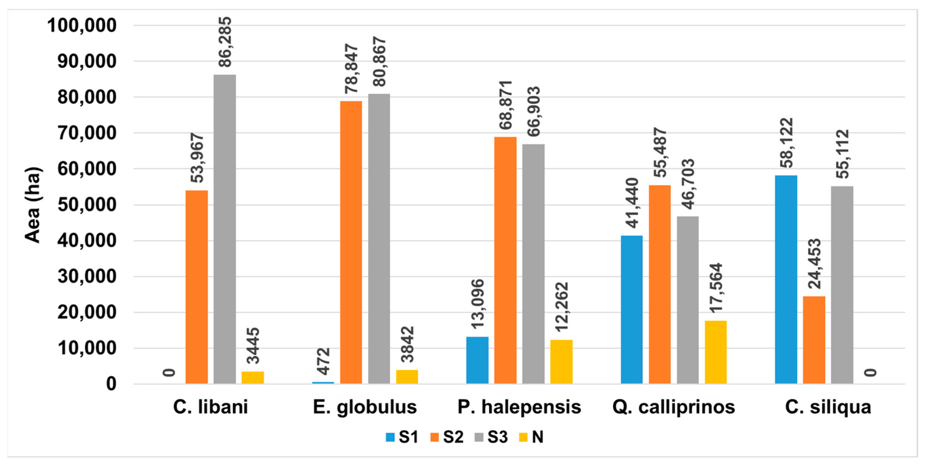
3.1. Land Suitability for the Current Period

The generated suitability maps allow for the computation of the area of suitable forestland for each forest species. The area is calculated from each suitability map of each forest species by vectorizing the suitability map (using the raster-to-vector function in ArcGIS) based on digital number values (i.e., the suitability class values) and summing the area of polygons belonging to the same suitability class (this procedure is performed using ArcGIS).
For the current climatic conditions, the results in Figure 3 show, for each forest species, the area of each suitability class in hectares (ha). The results indicate that Lebanese forestlands are highly suitable (S1) for the development of E. globulus, P. halepensis, Q. calliprinos, and C. siliqua, with areas of approximately 472, 13,096, 41,439, and 58,121 ha, respectively. Moreover, the results demonstrate that Lebanese forestlands are moderately (S2) and marginally (S3) suitable for the development of all considered species. However, some forestland areas are currently unsuitable (N) for the studied forest species, with approximately 3445, 3842, 12,262, and 17,564 ha suitable for C. libani, E. globulus, P. halepensis, and Q. calliprinos, respectively. Overall, most of the area of Lebanese forestlands is currently moderately (S2) to marginally (S3) suitable for all the studied species.
The geographical distribution of suitability classes was also analyzed using the generated suitability maps for each forest species. For Ceratonia siliqua (Figure 4a), high suitability (S1) was predominantly observed at lower altitudes near the coastline, spreading mainly from the north to the south (Figure 4a). Moderate (S2) and marginal (S3) suitability were observed primarily at higher altitudes (in Mount-Lebanon, Bekaa, and Baalbek-Hermel regions). All the suitable areas (S1, S2, and S3) for the Ceratonia siliqua species are located in the Thermo-Mediterranean, lower Eu-Mediterranean levels, and in humid and sub-humid bioclimatic zones of Lebanon, characterized by a temperate-to-warm winter (minimum temperature always above zero). However, the unsuitable areas (N) were found in specific regions characterized by high-altitude values (perhumid and Oro-Mediterranean).
For Cedrus libani (Figure 4b), the Lebanese forestlands are neither highly suitable nor unsuitable (Figure 1b), with moderate and marginal suitability observed across the entire forested areas. The suitability map reveals that the potential ecological niche for Cedrus libani (S2) is primarily found in the mountainous areas of Akkar, North Lebanon, Mount-Lebanon, and Baalbak-Hermel (i.e., the slopes of the Anti-Lebanon Mountains) (Figure 2b). Furthermore, the results indicate that marginal suitability (S3) is mainly observed in the south, Nabatyeh, and along the coastline. All the moderately suitable areas are located in the Mediterranean Montane and the upper Supra-Mediterranean levels, in humid and sub-humid bioclimatic zones, characterized by a cold winter (minimum temperature below zero).
Quercus calliprinos (Figure 4c) was observed in a wide habitat range within the territory. The generated suitability map shows that Quercus trees have the highest suitable area (S1), extending along the coastline from North Lebanon to South Lebanon, with the highest density in the slopes of the North and Mount-Lebanon regions (Figure 1c). The marginal and unsuitable areas are mainly in the eastern part of the country, Baalbek-Hermel, and Bekaa regions. All the suitable areas (S1 and S2) for Quercus are in the Thermo-Mediterranean and Eu-Mediterranean levels.
Eucalyptus globulus is an invasive tree native to Australian regions, and its introduction to the Lebanese forestlands is important due to its high wood productivity. Figure 4d shows that Lebanese forestlands are moderately to marginally suitable to support the development of Eucalyptus, with the moderately suitable areas (S2) mainly observed in Mount-Lebanon, North Lebanon, and Akkar regions. Furthermore, the results indicate that Lebanese forest lands are not highly suitable for Eucalyptus. The unsuitable areas are spread across Lebanon, with a high density in Baalbak-Hermel and Bekaa.
Pinus halepensis plays an ecological role in low and mid elevations. Based on Figure 4e, the species is predominantly highly suitable (S1) mainly in the Mount-Lebanon region. This species, along with Eucalyptus globulus, represents a significant surface area in the moderately suitable class (S2) for the currently established species. It should be noted that in Akkar and Nabatiyeh, the non-suitable classes (N) for Pinus halepensis are limited because Pinus is well adapted to the summer dry conditions and can thrive in burned areas.

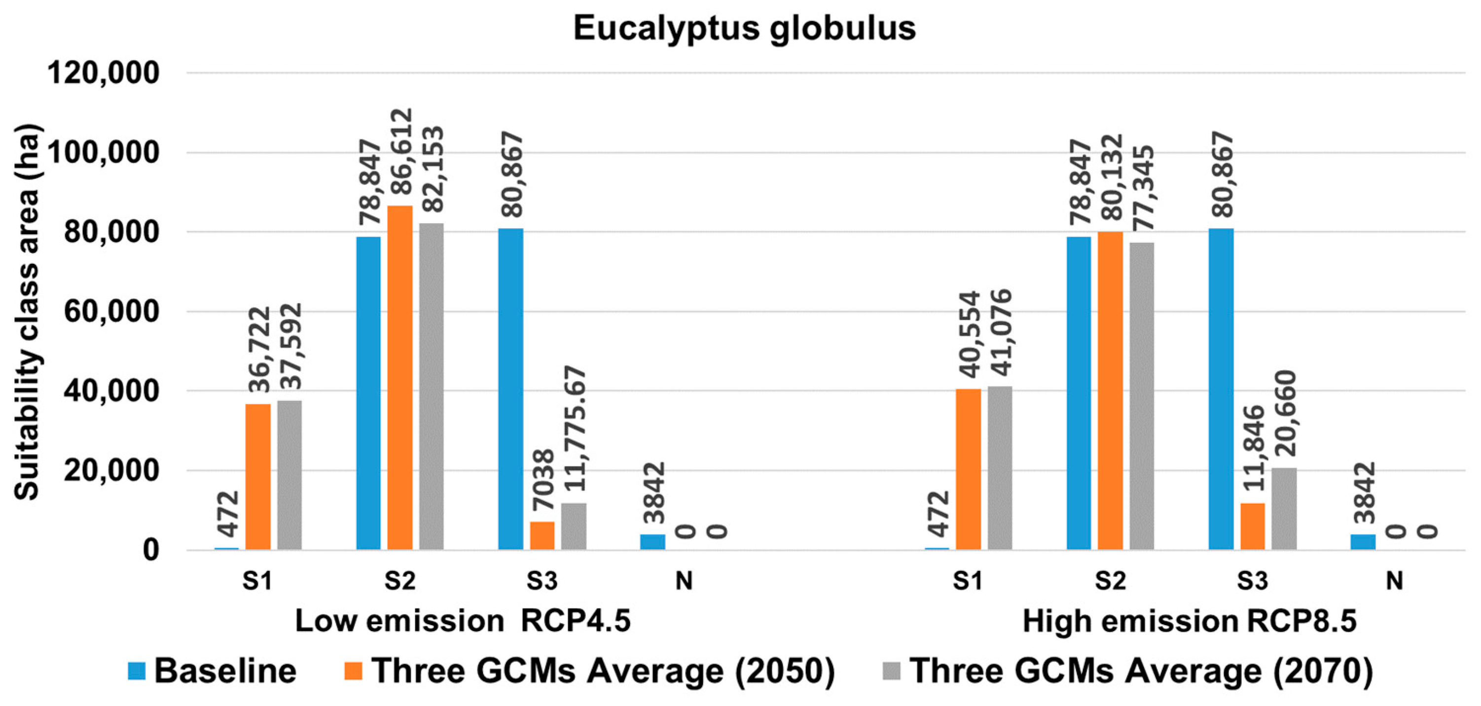
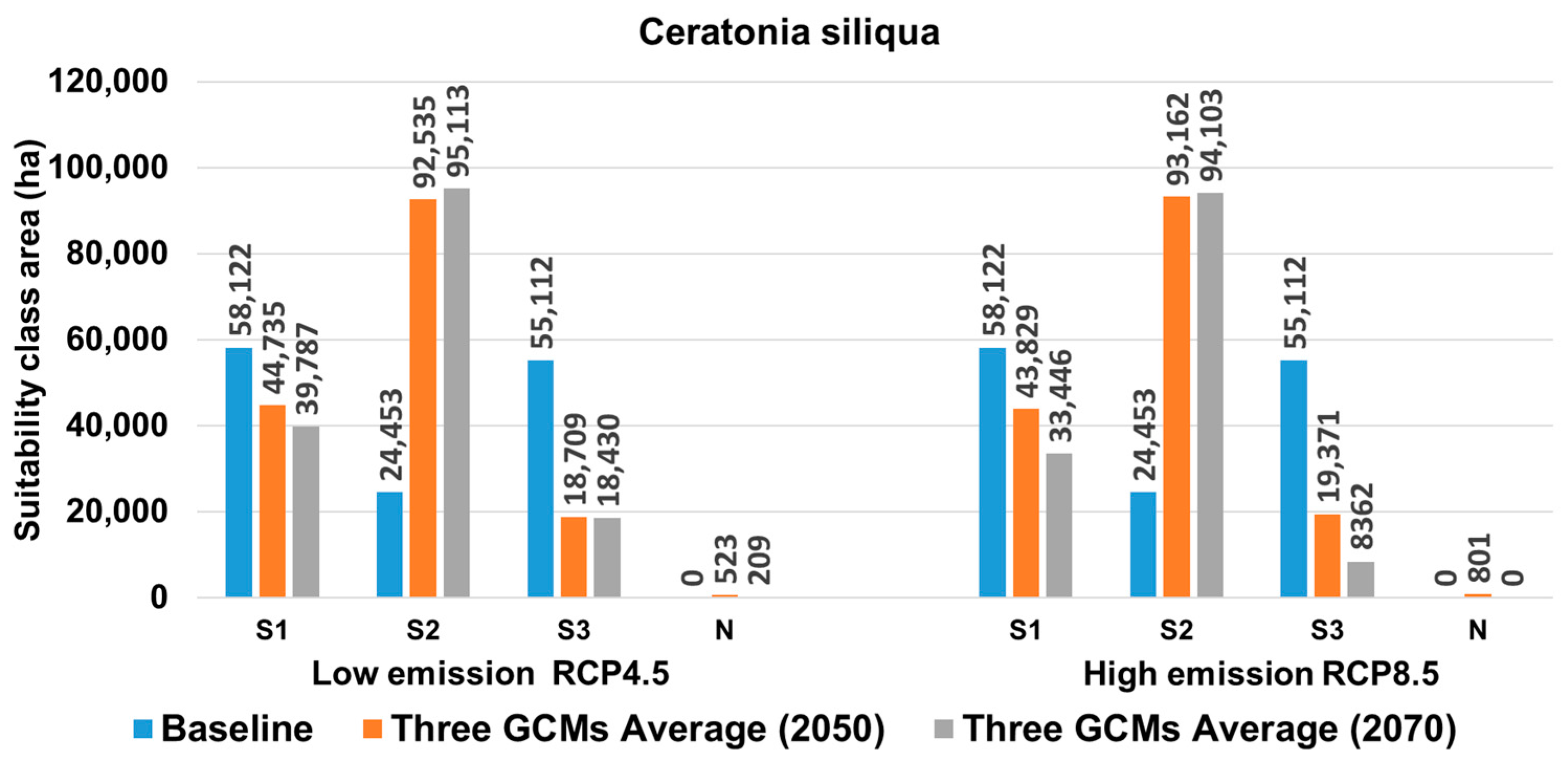
3.2. Land Suitability under Future Climate Projections

The employed method leveraged current knowledge (Table 3 and Table 4) regarding land suitability for five distinct forest species. Initially, it generated distribution maps for the present period and subsequently adapted them to estimate the variation in suitability areas in the projected future. In this study, the initial hypothesis, which included suitability maps for the current period and the derived area of each suitability class, was not validated using reference data due to their unavailability. Nevertheless, forest experts from CNRS-L, in conjunction with the literature sources [36,44], confirmed that the obtained maps align with reality. For instance, the map indicating that the Anti-mountain of Lebanon is the only suitable area for Cedrus libani is trustable, supported by the well-known presence of Cedrus in that region and corroborated by previous research [44]. Consequently, the study commences with a trustable initial assumption for projecting suitability in 2050 and 2070. Importantly, the projection results primarily focus on the changes in the areas of each suitability class under the current period. Consequently, the lack of validation for the initial assumption with ground truth data will not impact the conclusions, as only climatic projections were altered when projecting into the future, while topography and soil information were the same for both the current and future periods.
Climate projections from three different climatic models were used to project the suitability for the periods 2050 and 2070. For each species and each projection period, six suitability maps were generated from the three GCMs models (CCSM4, GFDL-CM3, and HadGem-ES) and the two scenarios (RCP4.5 and RCP8.5), resulting in twelve suitability maps for each species for the two projection periods (2050 and 2070). It is, therefore, impossible to display all these maps (60 maps for all species). Instead, for each species, the area of each suitability class was derived from each map (total twelve maps) and compared to the reference area of the same class (Figure 5, Figure 6, Figure 7, Figure 8 and Figure 9). To facilitate the analysis, for each species, each class, each climatic scenario (RCP4.5 and RCP8.5), and each projection period, the areas obtained from the three climatic models were averaged.
Figure 5 shows the future evolution of suitability class zones for Cedrus libani. According to RCP4.5, no highly suitable areas are expected to appear. S2 class areas are expected to remain approximately the same as today, S3 class areas are expected to decrease slightly, and unsuitable areas are expected to increase from 3445 ha to 29,274 ha in 2050 and to 19,476 ha in 2070. According to RCP8.5, no highly suitable areas are expected to appear. S2 class areas are expected to decrease from 53,967 ha to 30,589 ha in 2050 and to 17,455 ha in 2070. S3 class areas are expected to remain constant until 2050 (~86,000 ha) and decrease in 2070 (61,179 ha), and unsuitable areas are expected to increase in 2050 (from 3445 ha to 111,663 ha) and decrease later in 2070 to 24,179 ha. Overall, one can conclude that Cedrus libani is facing an extinction risk with the upcoming climate change.
For Eucalyptus globulus (Figure 6), highly suitable areas are expected to increase for both RCP4.5 and RCP8.5. They are expected to increase from 472 ha to 36,847 ha in 2050 and 37,592 ha in 2070 for RCP4.5, and from 472 ha to 40,554 ha in 2050 and 41,076 ha in 2070 for RCP8.5. The areas of the S2 class are expected to remain approximately similar in 2050 and 2070 compared to the current period, with an average area in 2050 and 2070 of around 81,560 ha. Marginally suitable (S3) areas are expected to significantly decrease (from 80,867 to about 12,830 on average) in 2050 and 2070 for both RCP4.5 and RCP8.5. Unsuitable areas (N) are also expected to decrease in 2050 and 2070, with 3842 ha and 0 ha, respectively. Accordingly, from the analysis, one can conclude that parts of the marginally suitable areas are expected to become highly suitable in 2050 and 2070.
Pinus halepensis is a thermophilic species, is drought-tolerant, and grows very well in its Mediterranean native habitat, where forest fires are frequent. It commonly spreads in Lebanon, especially in the southern part of the country. Its habitat bioclimatic level ranges from arid to humid, preferring a temperature between −2 to 10 °C and an annual precipitation of 350 to 750 mm. The results in Figure 7 show that highly suitable areas are expected to moderately decrease in 2050 and 2070 for both RCP4.5 and RCP8.5. For RCP4.5, S1 areas are expected to decrease by 937 ha and 902 ha in 2050 and 2070, respectively. For RCP8.5, S1 zones are expected to decrease by 1460 ha and 8149 ha in 2050 and 2070, respectively. S2 zones are expected to increase with both RCP4.5 (by 3318 ha in 2050 and 10,111 ha in 2070) and RCP8.5 (by 15,651 ha in 2050 and 21,678 ha in 2070). The S3 zone is expected to increase around 2070 under RCP4.5 (an increase of 5321 ha in 2050 and 7062 ha in 2070). Under RCP8.5, S3 is expected to increase by 1871 ha in 2050 and decrease by 1230 ha in 2070. It is important to note that unsuitable areas are expected to decrease in both 2050 and 2070, under both RCP4.5 and RCP8.5. For RCP4.5, the decrease is 8186 ha and 9335 ha in 2050 and 2070, respectively. For RCP8.5, S3 decreases sharply by 11,182 ha in 2050 and moderately later in 2070 by 453 ha between 2050 and 2070. Overall, one can conclude a moderate expansion of Pinus halepensis in 2050 and 2070.
For Quercus calliprinos (Figure 8), both RCPs indicate a significant decrease in highly suitable areas in 2050 and 2070, with a higher decrease in RCP4.5 (a decrease of 26,459 ha and 25,483 ha in 2050 and 2070 compared to the current situation). Regarding S2, an increase in areas is expected with both RCPs. For instance, with RCP4.5, an increase of 34,540 ha and 39,319 ha is expected in 2050 and 2070 compared to the current situation, respectively. For both RCPs, a significant decrease in marginally suitable areas is expected in the future. For RCP4.5, this decrease is 34,230 ha in 2050 and 35,482 ha in 2070. For RCP8.5, this decrease is 39,212 ha and 24,995 ha for 2050 and 2070, respectively. Moreover, results show that the unsuitable areas for Quercus calliprinos are expected to disappear in 2070. Overall, for Quercus calliprinos, S1, S3, and N are expected to change to become S2, indicating a future expansion for Quercus calliprinos in 2050–2070.
For Ceratonia siliqua (Figure 9), a similar variation trend of suitable areas is observed as for Quercus calliprinos, with S1, S3, and N expected to change (decrease in areas) to become S2 in the future projections.

4. Discussion

Forest suitability assessment is of significant importance in reforestation and future planning. The aim of this study was to explore the potential suitability of Lebanese forestlands under current and future (2050 and 2070) climatic conditions. The weighted overlay method was employed to produce suitability maps with four classes (S1, S2, S3, and N) using classification variables including altitude, temperature, annual precipitation, and soil type. Our findings suggest that climate change is expected to have a significant impact on forest biodiversity by influencing species distribution in Lebanon. Firstly, the results indicate that the current distribution of different suitability levels (S1, S2, S3, and N) varies across species, primarily due to the regional climate differences in Lebanon. Additionally, the results demonstrate that the area of each suitability class for a given species changes when different climate scenarios (utilizing three GCM models with two RCP scenarios) for climate projections are considered. The challenge in identifying tree species adapted to future climate scenarios lies in finding trees that can not only tolerate increased summer drought stress but are also resilient to present and future very low air temperatures in winter [50,51,52,53,54,55].
Ecological Niche Modeling has been widely used in recent decades to understand the spatial and temporal potential distribution of many plant and animal species. Most of these theoretical approaches focus on forecasting due to the expected global climate change in the twenty-first century. The Mediterranean Basin is expected to experience a generalized rise in mean temperatures, while rainfall patterns would become irregular [53]. Additionally, Regato and Salman [53] state that Mediterranean mountainous areas are at the forefront of global climate change, with increasing drought effects, rising and fluctuating temperatures, irregular and heavy precipitation, and more. Therefore, it is highly likely that climate change will occur in the future, underscoring the importance of studies that consider climate scenarios to provide land suitability maps for forestlands in Lebanon.
The results obtained in this study are consistent with the findings of previous works [56,57,58,59,60,61,62,63] and validate our initial hypothesis regarding the potential influence of climate change on the spatial distribution and change of land suitability. Our results indicate an increase in the unsuitable classes for Cedrus libani, with the absence of highly suitable areas in 2050 and 2070 under both RCPs (RCP 4.5 and RCP 8.5). This aligns with some studies that have concluded that Cedrus libani is on the path to extinction in Lebanon, primarily due to rising temperatures resulting from climate change. On the other hand, our results show that the distribution of thermophilic species such as Ceratonia siliqua, Quercus calliprinos, and Eucalyptus globulus, which thrive in moderately high temperatures, is projected to expand compared to the current situation, with the disappearance of unsuitable classes. The current distribution of Q. calliprinos in the present climate conditions supports the idea that the species could cover the entire forested areas in Lebanon characterized by a Mediterranean climate. The anticipated global warming in the context of climate change explains the expected expansion in the S2 classes and the decrease in the S3 class for Q. calliprinos, as it is a thermophilic species that can withstand drought. A similar rationale can be applied to Ceratonia siliqua and Pinus halepensis, both of which are adapted to the climate of the lower and mid zones of Lebanon, characterized by a temperate-to-warm winter with minimum temperatures always above freezing [64,65,66]. Consequently, as climate change progresses, changes in species distributions and forest communities are expected to occur across various altitudes. Similar conclusions have been drawn in other studies regarding species’ tolerances to increasing temperatures associated with future global warming [56,57,58,59,60].
In this study, climate, soil, and altitude were employed as suitability criteria to define four suitability classes (S1, S2, S3, and N). These suitability criteria were established based on information gathered from the literature, several field inventories, and the expertise provided by CNRS-L. While this approach may introduce some level of inaccuracy in mapping the current forest situation, a detailed analysis of the maps generated reveals that our results accurately represent the current conditions and, consequently, instill confidence in the defined criteria. For instance, the map indicating that the Anti-Lebanon Mountain is the sole suitable area for Cedrus libani aligns with established knowledge that this species is predominantly found in that region. Therefore, this mapping provides a solid foundation for reliable projections, as the climate data used in the projections were derived from GCM models, enhancing the credibility of our findings.
In this study, climate scenario simulation was employed to estimate suitability areas for various forest species, and consequently, the accuracy of our results is contingent on the precision of the climate models utilized. Regrettably, we were unable to validate the distribution maps for the current scenario or the results for future scenarios due to the absence of a forest reference map and the inherent challenges in validating climate models. Nevertheless, we conducted a qualitative validation based on the climatic tolerance of each species, bolstered by supporting research. Looking ahead, it is advisable for future studies to scrutinize the impact of varying factor weights on the maps and projections obtained. This would entail constructing maps and projections using different combinations of weight factors to enhance the comprehensiveness of the assessment.

5. Conclusions

The results emphasize the significance of land suitability analysis, indicating a critical shift in forest species distribution under climate change. The distribution of Ceratonia siliqua, Pinus halepensis, and Quercus calliprinos is projected to expand in 2050 and 2070, as current unsuitable areas will become moderately suitable in the future, likely due to the anticipated increase in temperature associated with future climate changes. However, the expansion of Cedrus libani is expected to decrease, with unsuitable areas expanding from 3445 ha to 17,476 ha and 24,179 ha under RCP4.5 and RCP8.5 in 2070, respectively. These findings can assist forest planners in rehabilitating forests by planting suitable species in appropriate locations, thereby increasing forest cover and conserving species like Cedrus libani from potential extinction.
Land suitability assessment using climate projections is a crucial element in guiding forest management strategies under climate change and identifying suitable sites for afforestation. This study represents one of the first attempts to assess land suitability regions for forest species, namely Ceratonia siliqua, Pinus halepensis, Quercus calliprinos, Eucalyptus globulus, and Cedrus libani, at a national level using spatial analysis tools in Lebanon. The analysis incorporated climate, soil, and altitude spatialized data to generate maps of land suitability for forest species under both current and future climatic conditions. As a recommendation, it is imperative to take into account the anticipated impacts of climate change when selecting species for reforestation, with the goal of preserving and expanding forest cover in Lebanon. Furthermore, the development of a robust monitoring and evaluation system is crucial for assessing the success of reforestation projects, including key performance indicators such as tree survival rates and biodiversity indices.

Author Contributions

Conceptualization, M.M. and N.J.; methodology, N.J. and V.M.; software, N.J.; validation, G.F., N.J., and M.M.; formal analysis, N.J.; investigation, N.J., N.N., and G.H.; resources, M.M.; data curation, G.F. and N.J.; writing—original draft preparation, N.J.; writing—review and editing, M.M., N.J., and V.M.; visualization, N.J.; supervision, M.M., N.N., and G.H.; project administration, M.M.; funding acquisition, M.M. All authors have read and agreed to the published version of the manuscript.

Funding

This research was funded by the University of Sassari, Italy. Grant number FAR2020MULASM.

Data Availability Statement

The data presented in this study are available on request from the corresponding author.

Conflicts of Interest

The authors declare no conflict of interest. The funders had no role in the design of the study; in the collection, analyses, or interpretation of data; in the writing of the manuscript; or in the decision to publish the results.

References

  1. FAO. FAO’s Work on Climate Change. In United Nations Climate Change; FAO: Rome, Italy, 2019; Volume 40. [Google Scholar]
  2. Masson-Delmotte, V.; Zhai, P.; Pirani, A.; Connors, S.L.; Péan, C.; Berger, S.; Caud, N.; Chen, Y.; Goldfarb, L.; Gomis, M.I. Contribution of Working Group I to the Sixth Assessment Report of the Intergovernmental Panel on Climate Change. Clim. Chang. 2021, 3, 31. [Google Scholar]
  3. Hansen, M.C.; Potapov, P.V.; Moore, R.; Hancher, M.; Turubanova, S.A.; Tyukavina, A.; Thau, D.; Stehman, S.V.; Goetz, S.J.; Loveland, T.R. High-Resolution Global Maps of 21st-Century Forest Cover Change. Science 2013, 342, 850–853. [Google Scholar] [CrossRef]
  4. Forestry Economics and Policy Division Food and Agriculture Organization of the United Nations, Global Forest Resources Assessment, Country Report Lebanon, Rome, 2010. Available online: https://www.fao.org/3/al549e/al549e.pdf (accessed on 1 January 2022).
  5. Sattout, E.; Zahreddine, H. Native Trees of Lebanon and Neighboring Countries: A Guidebook for Professionals & Amateurs; Notre Dame University: Notre Dame, IN, USA, 2013; ISBN 9953-558-47-7. [Google Scholar]
  6. Khater, C.; El-Hajj, R. Terrestrial Biodiversity in Lebanon; National Council for Scientific Research: Beirut, Lebanon, 2012; pp. 141–169. [Google Scholar]
  7. Palmer, T.; Ainslie, A. Country Pasture/Forage Resource Profiles. Food Agric. Organ. S. Afr. 2006. Available online: https://ees.kuleuven.be/eng/klimos/toolkit/documents/658_SouthAfrica_English.pdf (accessed on 1 January 2022).
  8. Ayoub, E.; Jamous, C.; Mhanna, M.; Team, C.; Solano, D.; Plana, E. Lebanon National Forest Program 2015–2025; German Agency for International Development: Bonn, Germany, 2015; Available online: https://faolex.fao.org/docs/pdf/leb163865.pdf (accessed on 1 January 2022).
  9. Bou Dagher-Kharrat, M.; Abdel-Samad, N.; Douaihy, B.; Bourge, M.; Fridlender, A.; Siljak-Yakovlev, S.; Brown, S.C. Nuclear DNA C-Values for Biodiversity Screening: Case of the Lebanese Flora. Plant Biosyst.-Int. J. Deal. Asp. Plant Biol. 2013, 147, 1228–1237. [Google Scholar] [CrossRef]
  10. Kelley, C.P.; Mohtadi, S.; Cane, M.A.; Seager, R.; Kushnir, Y. Climate Change in the Fertile Crescent and Implications of the Recent Syrian Drought. Proc. Natl. Acad. Sci. USA 2015, 112, 3241–3246. [Google Scholar] [CrossRef]
  11. Al-Qaddi, N.; Vessella, F.; Stephan, J.; Al-Eisawi, D.; Schirone, B. Current and Future Suitability Areas of Kermes Oak (Quercus coccifera L.) in the Levant under Climate Change. Reg. Environ. Chang. 2017, 17, 143–156. [Google Scholar] [CrossRef]
  12. Ministry of Environment. Lebanon’s Second National Communication to the UNFCCC; United Nation Development Program: Beirut, Lebanon, 2011.
  13. MOE/UNDP/ECODIT. Biodiversity and Forests. In State and Trends of the Lebanese Environment 2010–2011; 2011; Available online: https://www.pseau.org/outils/ouvrages/undp_state_and_trends_of_the_lebanese_environment_2011.pdf (accessed on 1 January 2022).
  14. Ministry of Agriculture. Strategy 2015–2019, Report, 2014. Available online: https://faolex.fao.org/docs/pdf/leb149670.pdf (accessed on 1 January 2022).
  15. Jacob, K.; Hudson, S.; Bush, M. Tools for Survival: An Analysis of Financial Literacy Programs for Lower-Income Families; Woodstock Institute: Chicago, IL, USA, 2000; Available online: https://assets.aecf.org/m/resourcedoc/woodstockinstitute-toolsforsurvivalfinancialliteracy-2000.pdf (accessed on 1 January 2022).
  16. Davis, L.; Johnson, K.; Bettinger, P.; Howard, T. Forest Management: To Sustain Ecological, Economic, and Social Values; McGraw Hill: Waveland, IL, USA, 2005; Volume 804. [Google Scholar]
  17. Bettinger, P.; Sessions, J. Spatial forest planning: To adopt, or not to adopt? J. For. 2003, 101, 24–29. [Google Scholar]
  18. MoE/UNDP/GEF. Safeguarding and Restoring Lebanon’s Woodland Resources Project. Socio-Economic Impact Assessment, Lebanon, technical report, 2014. Available online: https://www.undp.org/sites/g/files/zskgke326/files/migration/lb/SRLWR-Project-Final-Report-for-web-LR.pdf (accessed on 1 January 2022).
  19. Brown, H.; Liu, X.; Pokhrel, R.; Murphy, S.; Lu, Z.; Saleh, R.; Mielonen, T.; Kokkola, H.; Bergman, T.; Myhre, G. Biomass Burning Aerosols in Most Climate Models Are Too Absorbing. Nat. Commun. 2021, 12, 277. [Google Scholar] [PubMed]
  20. Liu, Y.; Deng, X. Structural Patterns of Land Types and Optimal Allocation of Land Use in Qinling Mountains. J. Geogr. Sci. 2001, 11, 99–109. [Google Scholar]
  21. Wandahwa, P.; Van Ranst, E. Qualitative Land Suitability Assessment for Pyrethrum Cultivation in West Kenya Based upon Computer-Captured Expert Knowledge and GIS. Agric. Ecosyst. Environ. 1996, 56, 187–202. [Google Scholar] [CrossRef]
  22. Kalogirou, S. Expert Systems and GIS: An Application of Land Suitability Evaluation. Comput. Environ. Urban Syst. 2002, 26, 89–112. [Google Scholar] [CrossRef]
  23. Wu, L.X.; Sun, B.; Zhou, S.L.; Huang, S.-E.; Zhao, Q.G. A New Fusion Technique of Remote Sensing Images for Land Use/Cover. Pedosphere 2004, 14, 187–194. [Google Scholar]
  24. Liu, Y.; Gao, J.; Yang, Y. A Holistic Approach towards Assessment of Severity of Land Degradation along the Great Wall in Northern Shaanxi Province, China. Environ. Monit. Assess. 2003, 82, 187–202. [Google Scholar] [CrossRef] [PubMed]
  25. Cudlín, P.; Cudlín, P.; Cudlín, P.; Tognetti, R.; Malis, F.; Alados, C.; Bebi, P.; Grunewald, K.; Zhiyanski, M.; Andonowski, V.; et al. Drivers of Treeline Shift in Different European Mountains. Clim. Res. 2017, 73, 135–150. [Google Scholar] [CrossRef]
  26. Mazahreh, S.; Bsoul, M.; Hamoor, D.A. GIS Approach for Assessment of Land Suitability for Different Land Use Alternatives in Semi Arid Environment in Jordan: Case Study (Al Gadeer Alabyad-Mafraq). Inf. Process. Agric. 2019, 6, 91–108. [Google Scholar] [CrossRef]
  27. Abdallah, C.; Jaafar, H. Data Set on Current and Future Crop Suitability under the Representative Concentration Pathway (RCP) 8.5 Emission Scenario for the Major Crops in the Levant, Tigris-Euphrates, and Nile Basins. Data Brief 2019, 22, 992–997. [Google Scholar] [CrossRef]
  28. Chen, I.-C.; Hill, J.K.; Ohlemüller, R.; Roy, D.B.; Thomas, C.D. Rapid Range Shifts of Species Associated with High Levels of Climate Warming. Science 2011, 333, 1024–1026. [Google Scholar] [CrossRef]
  29. Marchi, M.; Nocentini, S.; Ducci, F. Future Scenarios and Conservation Strategies for a Rear-Edge Marginal Population of Pinus Nigra Arnold in Italian Central Apennines. For. Syst. 2016, 25, e072. [Google Scholar] [CrossRef]
  30. Liu, Y.-S.; Hu, Y.-C.; Peng, L.-Y. Accurate Quantification of Grassland Cover Density in an Alpine Meadow Soil Based on Remote Sensing and GPS. Pedosphere 2005, 15, 778–783. [Google Scholar]
  31. Darwish, T.; Zdruli, P.; Saliba, R.; Awad, M.; Shaban, A.; Faour, G. Faour Vulnerability to Desertification in Lebanon Based on Geo-Information and Socioeconomic Conditions. J. Environ. Sci. Eng. B 2012, 1, 851–864. [Google Scholar]
  32. Karam, F.; Doulis, A.; Ozturk, M.; Dogan, Y.; Sakcali, S. Eco—Physiological Behaviour of Two Woody Oak Species to Combat Desertification in the East Mediterranean-a Case Study from Lebanon. Procedia-Soc. Behav. Sci. 2011, 19, 787–796. [Google Scholar] [CrossRef]
  33. Douaihy, B.; Tarraf, P.; Stephan, J. Juniperus Drupacea Labill. Stands in Jabal Moussa Biosphere Reserve, a Pilot Study for Management Guidelines. Plant Sociol. 2017, 54, 39–45. [Google Scholar] [CrossRef]
  34. Stephan, J.; Chayban, L.; Vessella, F. Abiotic Factors Affecting the Distribution of Oaks in Lebanon. Turk. J. Bot. 2016, 40, 595–609. [Google Scholar] [CrossRef]
  35. Stephan, J.; Bercachy, C.; Bechara, J.; Charbel, E.; López-Tirado, J. Local Ecological Niche Modelling to Provide Suitability Maps for 27 Forest Tree Species in Edge Conditions. IForest-Biogeosciences For. 2020, 13, 230–237. [Google Scholar] [CrossRef]
  36. Kattar, S.; Rjeily, K.A.; Souidi, Z.; Aoun, G.; Moukarzel, R.; Kallas, G. Evaluation of Land Suitability for Stone Pine (Pinus pinea) Plantation in Lebanon. Int. J. Environ. Agric. Biotechnol. 2017, 2, 563–583. [Google Scholar] [CrossRef] [PubMed]
  37. Mouterde, P.S.J. Nouvelle Flore Du Liban et de La Syrie; Editions de l’Impr. Catholique: Beyrouth, Lebanon, 2018. [Google Scholar]
  38. Bozkurt, D.; Sen, O.L. Climate Change Impacts in the Euphrates–Tigris Basin Based on Different Model and Scenario Simulations. J. Hydrol. 2013, 480, 149–161. [Google Scholar] [CrossRef]
  39. Bozkurt, D.; Turuncoglu, U.; Sen, O.L.; Onol, B.; Dalfes, H.N. Downscaled Simulations of the ECHAM5, CCSM3 and HadCM3 Global Models for the Eastern Mediterranean–Black Sea Region: Evaluation of the Reference Period. Clim. Dyn. 2012, 39, 207–225. [Google Scholar] [CrossRef]
  40. Giannakopoulos, C.; Kotroni, V.; Lagouvardos, K.; Korakaki, E.; Hatzaki, M.; Tenentes, V.; Roussos, A.; Karali, A.; Goodess, C. Providing Tailored Climate Information to Forest Fire Stakeholders and End-Users. In Proceedings of the EGU General Assembly Conference Abstracts, Vienna, Austria, 7–12 April 2013. [Google Scholar]
  41. Prasad, M.N.V.; Pietrzykowski, M. Climate Change and Soil Interactions; Elsevier: Amsterdam, The Netherlands, 2020. [Google Scholar]
  42. Fick, S.E.; Hijmans, R.J. WorldClim 2: New 1-km Spatial Resolution Climate Surfaces for Global Land Areas. Int. J. Climatol. 2017, 37, 4302–4315. [Google Scholar] [CrossRef]
  43. FAO. A Framework for Land Evaluation: Soils Bulletin; Food and Agriculture Organization of the United Nations: Rome, Italy, 1976. [Google Scholar]
  44. Hajar, L.; François, L.; Khater, C.; Jomaa, I.; Déqué, M.; Cheddadi, R. Cedrus libani (A. Rich) Distribution in Lebanon: Past, Present and Future. C. R. Biol. 2010, 333, 622–630. [Google Scholar] [CrossRef]
  45. Cerasoli, S.; Caldeira, M.C.; Pereira, J.S.; Caudullo, G.; De Rigo, D. Eucalyptus Globulus and Other Eucalypts in Europe: Distribution, Habitat, Usage and Threats. Eur. Atlas For. Tree Species 2016, 90–91. Available online: https://w3id.org/mtv/FISE-Comm/v01/e01b5bb (accessed on 1 January 2022).
  46. Camarero, J.J.; Sánchez-Salguero, R.; Ribas, M.; Touchan, R.; Andreu-Hayles, L.; Dorado-Liñán, I.; Meko, D.M.; Gutiérrez, E. Biogeographic, Atmospheric, and Climatic Factors Influencing Tree Growth in Mediterranean Aleppo Pine Forests. Forests 2020, 11, 736. [Google Scholar] [CrossRef]
  47. Kim, H.N.; Jin, H.Y.; Kwak, M.J.; Khaine, I.; You, H.N.; Lee, T.Y.; Ahn, T.H.; Woo, S.Y. Why Does Quercus Suber Species Decline in Mediterranean Areas? J. Asia-Pac. Biodivers. 2017, 10, 337–341. [Google Scholar] [CrossRef]
  48. Baumel, A.; Nieto Feliner, G.; Médail, F.; La Malfa, S.; Di Guardo, M.; Bou Dagher Kharrat, M.; Lakhal-Mirleau, F.; Frelon, V.; Ouahmane, L.; Diadema, K. Genome-wide Footprints in the Carob Tree (Ceratonia siliqua) Unveil a New Domestication Pattern of a Fruit Tree in the Mediterranean. Mol. Ecol. 2022, 31, 4095–4111. [Google Scholar] [CrossRef]
  49. Kassout, J.; Hmimsa, Y.; El Fatehi, S.; El Ouahrani, A.; Kadaoui, K.; Chakkour, S.; Ariza-Mateos, D.; Palacios-Rodríguez, G.; Navarro-Cerrillo, R.; Ater, M. Image Analysis of Moroccan Carob Seeds (Ceratonia siliqua L.) Revealed Substantial Intraspecific Variations Depending on Climate and Geographic Origin. Ecol. Process. 2022, 11, 34. [Google Scholar] [CrossRef]
  50. Alemayehu, F.; Taha, N.; Nyssen, J.; Girma, A.; Zenebe, A.; Behailu, M.; Deckers, S.; Poesen, J. The Impacts of Watershed Management on Land Use and Land Cover Dynamics in Eastern Tigray (Ethiopia). Resour. Conserv. Recycl. 2009, 53, 192–198. [Google Scholar] [CrossRef]
  51. Perrin, A.; Cristobal, M.S.; Milestad, R.; Martin, G. Identification of Resilience Factors of Organic Dairy Cattle Farms. Agric. Syst. 2020, 183, 102875. [Google Scholar] [CrossRef]
  52. IPCC. Climate Change 2014: Synthesis Report. Contribution of Working Groups I, II and III to the Fifth Assessment Report of the Intergovernmental Panel on Climate Change; IPCC: Geneva, Switzerland, 2014. [Google Scholar]
  53. Regato, P.; Salman, R. Mediterranean Mountains in a Changing World: Guidelines for Developing Actions Plans; IUCN: Gland, Switzerland, 2008; ISBN 978-2-8317-1058-7. [Google Scholar]
  54. Rossiter, D.G. A Theoretical Framework for Land Evaluation. Geoderma 1996, 72, 165–190. [Google Scholar] [CrossRef]
  55. Francis, J.A.; Vavrus, S.J. Evidence Linking Arctic Amplification to Extreme Weather in Mid-Latitudes: Arctic Links to Mid-Latitude Weather. Geophys. Res. Lett. 2012, 39. [Google Scholar] [CrossRef]
  56. Kelly, A.E.; Goulden, M.L. Rapid Shifts in Plant Distribution with Recent Climate Change. Proc. Natl. Acad. Sci. USA 2008, 105, 11823–11826. [Google Scholar] [CrossRef]
  57. Lenoir, J.; Gégout, J.C.; Marquet, P.A.; De Ruffray, P.; Brisse, H. A Significant Upward Shift in Plant Species Optimum Elevation During the 20th Century. Science 2008, 320, 1768–1771. [Google Scholar] [CrossRef]
  58. Parmesan, C. Ecological and Evolutionary Responses to Recent Climate Change. Annu. Rev. Ecol. Evol. Syst. 2006, 37, 637–669. [Google Scholar] [CrossRef]
  59. Gonzalez, P.; Neilson, R.P.; Lenihan, J.M.; Drapek, R.J. Global Patterns in the Vulnerability of Ecosystems to Vegetation Shifts Due to Climate Change: Global Vulnerability to Climate Change. Glob. Ecol. Biogeogr. 2010, 19, 755–768. [Google Scholar] [CrossRef]
  60. Hayhoe, K.; Cayan, D.; Field, C.B.; Frumhoff, P.C.; Maurer, E.P.; Miller, N.L.; Moser, S.C.; Schneider, S.H.; Cahill, K.N.; Cleland, E.E.; et al. Emissions Pathways, Climate Change, and Impacts on California. Proc. Natl. Acad. Sci. USA 2004, 101, 12422–12427. [Google Scholar] [CrossRef] [PubMed]
  61. Ducrey, M.; Huc, R.; Ladjal, M.; Guehl, J.-M. Variability in Growth, Carbon Isotope Composition, Leaf Gas Exchange and Hydraulic Traits in the Eastern Mediterranean Cedars Cedrus libani and C. Brevifolia. Tree Physiol. 2008, 28, 689–701. [Google Scholar] [CrossRef]
  62. Bolte, A.; Ammer, C.; Löf, M.; Nabuurs, G.-J.; Schall, P.; Spathelf, P. Adaptive Forest Management: A Prerequisite for Sustainable Forestry in the Face of Climate Change. In Sustainable Forest Management in a Changing World: A European Perspective; Spathelf, P., Ed.; Managing Forest Ecosystems; Springer: Dordrecht, The Netherlands, 2009; Volume 19, pp. 115–139. ISBN 978-90-481-3300-0. [Google Scholar]
  63. Milad, M.; Schaich, H.; Konold, W. How Is Adaptation to Climate Change Reflected in Current Practice of Forest Management and Conservation? A Case Study from Germany. Biodivers. Conserv. 2013, 22, 1181–1202. [Google Scholar] [CrossRef]
  64. Llanderal-Mendoza, J.; Gugger, P.F.; Oyama, K.; Uribe-Salas, D.; González Rodríguez, A. Climatic Determinants of Acorn Size and Germination Percentage of Quercus Rugosa (Fagaceae) along a Latitudinal Gradient in Mexico. Bot. Sci. 2017, 95, 37–45. [Google Scholar] [CrossRef]
  65. Mojzes, A.; Ónodi, G.; Lhotsky, B.; Kalapos, T.; Csontos, P.; Kröel-Dulay, G. Within-Generation and Transgenerational Plasticity in Growth and Regeneration of a Subordinate Annual Grass in a Rainfall Experiment. Oecologia 2018, 188, 1059–1068. [Google Scholar] [CrossRef]
  66. Skov, F.; Svenning, J.-C. Potential Impact of Climatic Change on the Distribution of Forest Herbs in Europe. Ecography 2004, 27, 366–380. [Google Scholar] [CrossRef]
Figure 1. Map of Lebanon showing altitude variations.
Forests 14 01893 g001
Figure 2. Method flow chart.
Forests 14 01893 g002
Figure 3. Land suitability classes for selected species in Lebanon for the current period (1970–2000).
Forests 14 01893 g003
Figure 4. Current situation of land suitability map for Ceratonia siliqua (a), Cedrus libani (b), Quercus calliprinos (c), Eucalyptus globulus (d), and Pinus halepensis (e).
Forests 14 01893 g004
Figure 5. Changes of land suitability class for Cedrus libani under different emission scenarios, expressed as variation in areas (ha).
Forests 14 01893 g005
Figure 6. Changes of land suitability class for Eucalyptus globulus under different emission scenarios, expressed as variation in areas (ha).
Forests 14 01893 g006
Figure 7. Changes of land suitability class for Pinus halepensis under different emission scenarios, expressed as variation in areas (ha).
Forests 14 01893 g007
Figure 8. Changes of land suitability class for Quercus calliprinos under different emission scenarios, expressed as variation in areas (ha).
Forests 14 01893 g008
Figure 9. Changes of land suitability class for Ceratonia siliqua under different emission scenarios, expressed as variation in areas (ha).
Forests 14 01893 g009
Table 1. Characteristics of studied species (modified by [5]). Mon-M: Montane-Mediterranean; T-M: Thermo-Mediterranean; and Eu-M: Eu-Mediterranean.
SpeciesEnglish NameAverage HeightFlowering PeriodFruiting PeriodAltitudeVegetation LevelDominant Soil Type
Cedrus libaniLebanese cedar30–40 mOct.–Nov.Autumn1200–2000 mMon-MCalcareous soil
Ceratonia siliquaCarob<10 mJuly–OctoberSept.–Oct.0–1000 mT-M and Eu-MCalcareous soil
Pinus halepensisAleppo pine15–25 mApril–MaySept.–Oct.0–1500 mT-M and Eu-MMarl-calcareous
Quercus calliprinosGall oak<10 mMarch–AprilAutumn500–800 mEu-MCalcareous soil
Eucalyptus globulusTasmanian blue gum40–55 mMaySeptember0–1300 mT-M and Eu-MCalcareous soil
Table 2. Climatic data used as input for land suitability assessment.
Climate ModelRepresentative Concentration Pathways1970–200020502070
Climate research unit x
CCSM4 RCP4.5 xx
RCP8.5 xx
GFDL-CM3RCP4.5 xx
RCP8.5 xx
HadGEM2-ESRCP4.5 xx
RCP8.5 xx
Table 3. Classification of variables according to suitability classes.
SpeciesLand SuitabilityAltitude (m)Temperature Range (°C)Annual Precipitation (mm)Soil Type
Cedrus libaniS11200–20003–91371–1906Calcareous
S2600–12009–151200–1349Calcareous limestone
S3500–60015–23.4692–1026Sandy
N>2400<−7 and >23.5
Eucalyptus globulusS1500–100012–18600–1100Sandy-clay
S20–50018–251100–1600Sandy-loam
S31000–1500−5–12500–600Clay
N <−5 and >30<500Calcareous
Pinus halepensisS1500–80014.5–19.3350–700Sandy,
S2800–10000.4–14.5700–1000Loamy soil
S30–50019.3–32.6182–350Dry soil
N <−5 and >35
Quercus calliprinosS1100–5007.2–21400–800Limestone soils
S2500–100021–40800–1295Calcareous limestone
S31000–1500−5–7.2300–400All types of soils
N <−5
Ceratonia siliquaS10–30015–20550–1100Calcareous
S2300–50020–32250–550Alluvial
S3500–8007.8–151100–1300Rocky
N<800<−4250–1300
Table 4. Weight of the classification variables [36,50,51].
FactorsSub-FactorsWeight
ClimateAnnual precipitation0.40
Annual temperature0.35
TopographyAltitude0.15
SoilSoil type0.10
Total 1
Disclaimer/Publisher’s Note: The statements, opinions and data contained in all publications are solely those of the individual author(s) and contributor(s) and not of MDPI and/or the editor(s). MDPI and/or the editor(s) disclaim responsibility for any injury to people or property resulting from any ideas, methods, instructions or products referred to in the content.

