Article

Spatial Zoning of the Value Realization Models for Ecological Products in Shibing Karst Natural World Heritage Site

School of Karst Science, Engineering Laboratory for Karst Desertification Control and Eco-Industry of Guizhou Province, Guizhou Normal University, Guiyang 550001, China
*
Author to whom correspondence should be addressed.
Forests 2023, 14(7), 1449; https://doi.org/10.3390/f14071449
Submission received: 16 May 2023 / Revised: 10 July 2023 / Accepted: 12 July 2023 / Published: 14 July 2023
(This article belongs to the Special Issue Forest Ecosystem Services and Landscape Design - Series II)

Abstract

:
Natural World Heritage properties provide humanity with a rich and diverse range of ecological products, and the realization of their economic value is related to heritage protection and the improvement of community residents’ well-being. In this study, the equivalent factor method was used to calculate the ecological product value (EPV), and the fishnet tool in ArcGIS was used for spatial zoning. The main land use type of the study area is forest land, accounting for over 82% of the total area. The conversion of land use types is weak in the property and strong in the buffer zone. The EPV of the study area was about USD 172.41 million, showing a downward trend before World Heritage inscription but an upward trend after the inscription, with forests as the main contributor. The spatial distribution of the ecosystem service value of the study area has obvious hierarchical characteristics. World Heritage inscription is beneficial for maintaining the stability of land use and for the improvement of the EPV of the property. The high- and low-EPV areas, respectively, are related to the distribution of forests and agricultural land. The dominant models of EPV in the study area are ecological forestry economy, water economy, and ecological agricultural economy.

1. Introduction

Ecosystems can yield vital services for human beings, such as food supply, soil and water conservation, climate regulation, beauty, and serenity [1]. These ecosystem services have value and should be realized in commercial markets [2]. Ecosystem service value (ESV) refers to the total value of ecosystem services in a region, also known as the gross ecosystem product (GEP), which is the total value of products and services provided by the ecosystem to humans [3]. GEP is a novel aggregate measure of the value of ecosystem services [4]. Although some researchers believe that ecological products place more emphasis on market attributes, different from ecosystem services [5], GEP is widely used for calculating the ecological product value (EPV) [6,7,8]. Therefore, EPV can be regarded as the same as ESV when calculating the value. The main difference between ecological products and ecosystem services lies in their conceptual attributes. Ecosystem services focus on the natural attributes of ecosystems, while ecological products emphasize the social and market attributes of ecosystems.
The accounting of ESV is the foundation for EPV realization and ecological compensation. Daily [9] stated that the value calculation of global ecosystem services in 1997 attracted widespread global attention to ecosystem services, products, and their value accounting. Researchers from various disciplines such as ecology, economics, and geography have conducted ESV accounting at different scales, including regional, provincial, national, and global levels. At present, there are two main types of methods for calculating ESV. One is the method based on unit service function price (referred to as function value method), and the other is the method based on the unit area value equivalent factor (referred to as equivalent factor method). The functional pricing method is represented by the United Nations [10] and Ouyang Zhiyun [11], with typical methods being SEEA EA (system of environmental–economic accounting ecosystem accounting) and GEP. This type of method obtains the total value by calculating the functional quantity and unit price of each ecosystem service based on the classification of ecosystem types. It simulates the ecosystem service functions of small regions by establishing a production equation between a single service function and local ecological environment variables [12,13]. However, this kind of method has many input parameters and complex calculation processes. More importantly, the evaluation methods and parameter standards for each service value are difficult to unify [14,15], making it difficult to conduct vertical comparisons across time scales in the same region and horizontal comparisons across different regions. The equivalent factor method is represented by Costanza [16] and Xie [17]. This method is based on distinguishing the service functions of different types of ecosystems, constructing the value equivalents of various service functions of different types of ecosystems based on quantifiable standards and then evaluating them based on the distribution area of the ecosystem [17]. Compared to the functional value method, the equivalent factor method is more intuitive and easier to use, with less data demand, and is particularly suitable for evaluating ESV at regional and global scales [18,19].
The 2030 Agenda for Sustainable Development, adopted at the 70th session of the United Nations General Assembly in 2015, marked the beginning of a new era for humanity towards a sustainable society [20]. Although goal 15 and other related goals emphasized the importance of terrestrial ecosystems and desertification control [21], desertification is still an issue threatening ecological security and human well-being, especially in ecologically fragile karst areas [22]. The karst region is one of the main ecologically fragile zones in the world [23,24,25], and its ecological and environmental issues have for a long-time been a hot topic in international geoscience research [26,27]. South China Karst is a typical representative of global tropical and subtropical karst, and its research and management of rocky desertification is very representative [28].
A karst protected area is one of the special types of ecological protection areas, and the issue of synergy between the fragile ecological environment and urgent economic development needs is particularly urgent [29]. It is characterized by water leakage and extreme drought [30], a slow soil formation rate and thin soil layer [31,32,33], and a large slope and severe soil erosion [34,35]. Once vegetation is destroyed, it is difficult to recover. The value of its ecosystem services is not yet clear, and there is a lack of effective models for value realization [36]. The delineation of karst protected areas mainly considers natural attributes, and their spatial boundaries may not necessarily coincide with administrative boundaries. Therefore, it is difficult to obtain complete statistical data, which increases the difficulty of calculating the ESV of karst protected areas. The equivalent factor method is more intuitive and easier to use, with less data demand, and is suitable for calculating the EPV in karst protected areas. In recent years, the realization of the EPV has gradually become a research hotspot in fields such as ecology, geography, and economics [37,38,39]. However, existing relevant research mostly focuses on theoretical research and experience summary [40,41,42,43], while little attention has been paid to the value realization models for ecological products and their spatial zoning. In response to this issue, some researchers have used the analytic hierarchy process and entropy method [44], expert scoring method [45], and other methods to conduct suitability evaluation and spatial zoning of the value realization of ecological products. These studies have promoted quantitative analysis of the realization models of EPV, but the determination of indicator system weights is highly subjective.
To objectively analyze the realization models and paths of EPV, this study proposes a spatial zoning method for the value realization models of ecological products based on EPV. To achieve this main objective, we need to address three issues. The first is the spatiotemporal changes in land use, which is the basis for calculating EPV. The second is the spatiotemporal pattern of EPV, which is the key to selecting EPV realization models. Based on land use and socio-economic data, the equivalent factor method is used to calculate the EPV of the study area. The third is the dominant models and paths of EPV realization. The fishnet tool in ArcGIS was used to explore the dominant industry models and implementation paths based on EPV. This study may promote the implementation of EPV in specific administrative regions. It can provide research ideas and methodological references for the improvement of ecological security and human well-being in karst protected areas.

2. Materials and Methods

2.1. Study Area

The South China Karst Natural World Heritage site is one of the most outstanding landscapes in the world and also one of the most vulnerable ecosystems on earth. Shibing Karst (N 27°05′49″–N 27°13′59″, E 108°01′34″–E 108°09′32″), one of the components of South China Karst, was chosen as our study area. It is located in Shibing County, Guizhou Province, in the southwest of China. The area includes the World Heritage property (102.80 km2) and its buffer zone (180.15 km2), belonging to the mid-subtropical karst valley area (Figure 1). The relief is high in the north and low in the south and shows a karst landscape whose most significant landforms are the fengcong canyons. They are typical representatives of subtropical dolomite karst. In 2014, it was inscribed on World Heritage List by the UNESCO World Heritage Center for meeting the world heritage criteria VII (aesthetic value) and VIII (geological and geomorphic value).
The study area belongs to a subtropical humid monsoon climate with a frost-free period of 255–294 days. The altitude is from 494 m to 1579 m a.s.l., with an average elevation of 1085 m a.s.l. The annual average temperature is 16 °C, and the average annual precipitation is 1220 mm. The study area involves 15 villages, including Tangtou Village, Chayuan Village, Baiduo Village, and so on. It has multiple protection attributes such as a Natural World Heritage site, a national scenic spot, a national geological park, and a national key ecological functional area. These titles not only enhance the tourism attractiveness of the study area but also set limitations on the local economic development due to its natural conservation requirements, making the balance and synergy between ecological protection and economic development highly representative of karst protected areas.

2.2. Equivalent Factor Method

2.2.1. Standard Equivalent Calculation

The EPV was calculated using values derived by Costanza et al. [16] and modified by Xie et al. [46]. The value of the one-unit equivalent factor is defined as 1/7 of the market value of grain crops per unit area. According to the 2018 Statistical Yearbook of Shibing County, the main grain crops in the study area include grains, beans, and potatoes. According to the planting area, yield, and output value of the main grain crops in Shibing County from the Yearbook, the unit price of each grain crop can be calculated (Table 1). The value of the standard equivalent is 1/7 of the unit yield value of the above-mentioned crops, and it is calculated as shown in Equation (1).
V a = 1 7 i = 1 n a i p i q i A   i = 1 , 2 , n ,
In Equation (1), V a represents the economic value generated by planting a certain crop on a unit area of farmland in Shibing County (USD ha−1); i represents the types of crops, including three types in Shibing; p i represents the purchase price of the type i crop in a year (USD kg−1); q i represents the yield per unit area of the type i crop (kg ha−1); a i represents the total planting area of the type i crop (kg ha−1); and A represents the total planting area of the three types of crops (ha). After calculation, it is found that V a is USD 298.95.

2.2.2. Revised Ecological Product Value Equivalent Coefficient

The land use types in the study area are divided into 8 categories: dryland, paddy field, forests, shrub, grassland, bare land, water, and construction land. However, the impact of construction land on the environment is cumulative, and its ecosystem service value is difficult to fully quantify [47,48]. Therefore, construction land is not included when calculating the EPV. After the above steps, the economic value generated by planting corresponding crops per unit area of farmland in the study area can be determined (Table 2). The ecosystem service equivalent value per unit area proposed by Xie et al. [49] was revised for the study area with Equation (2).
V E i j = C i j V a   i = 1 , 2 , n ,
In Equation (2), V E i j represents the ecosystem product value coefficient of a type j ecological service function included in a type i ecosystem in the study area (USD ha−1); C i j represents the economic value of a type j service function contained in a type i ecosystem in the study area compared to 1 unit area of farmland in Shibing County; i represents the type of ecosystem in the study area; j represents the corresponding service functions of each ecosystem in the study area; and V a represents the economic value generated by planting crops per unit area of farmland in Shibing County (USD ha−1).

2.2.3. Calculation of EPV

Based on the above standard equivalent and revised EPV equivalent coefficient, the EPV of Shibing Karst was calculated by using Equation (3) [50].
EPV = A k E k ,
In Equation (3), EPV represents the total ecological product value of the study area (USD); A k represents the area of land type k in the study area; and E k represents the EPV corresponding to 1 unit area of land type k (USD ha−1).

2.3. Spatial Zoning Method of the Main EPV Realization Models

The first step is to calculate the value of each ecological product (from A1 to D1 in Table 2) under the four service types of supply service (A), regulation service (B), support service (C), and cultural service (D).
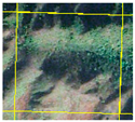
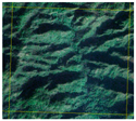
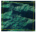
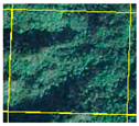
The second step is to create a fishnet in ArcGIS10.8. By setting the fishnet with sizes of 1000 m, 500 m, and 250 m, it was found that when the size of the fishnet is 250 m, the representativeness of the main land types in the grid is better (Table 3). Therefore, a 250 m grid is chosen as the basic unit boundary size for spatial zoning.
The third step is to extract the area of various categories from the grid units of the fishnet and use a field calculator to calculate the EPV of each grid. Then, the EPV of each service type is calculated through the fields to generate the total EPV.

2.4. Data Sources

The data on the land area, yield, and average price of the main crops in Shibing County are from the Shibing County Statistical Yearbook. Land use data is from the Geospatial Data Cloud (http://www.gscloud.cn/, accessed on 20 August 2022). The spatial resolution is 30 m. Shibing Karst was inscribed on the World Heritage List in 2014, so Landsat5/8 images of 2009, 2013, 2016, and 2021 were selected to reflect the differences before and after the inscription. In ENVI5.3, the maximum likelihood classifier in supervised classification is used to extract land use types. ArcGIS 10.8 is used to classify and merge the land use data in the study area, which is divided into 8 categories: dryland, paddy field, forests, shrub, grassland, bare land, water, and construction land. By comparing Google Earth high-resolution images, field survey data, and land use classification results, manual modifications were made to the misclassified land use types. The accuracy of classification results based on the real area of interest on the surface was greater than 90%.

3. Results

3.1. Spatiotemporal Changes in Land Use

3.1.1. Temporal Changes in Land Use

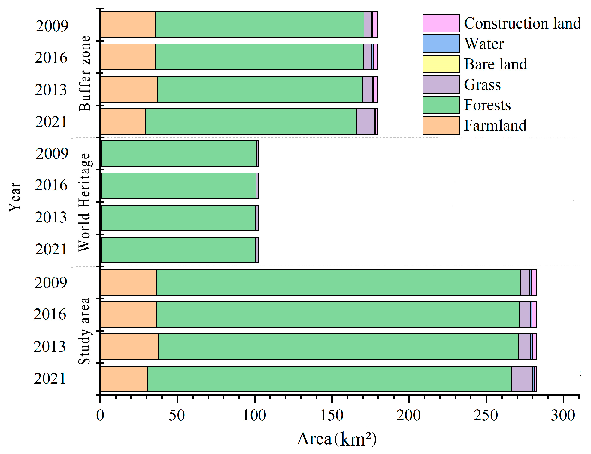
The land use types of the study area from 2009 to 2021 were mainly forests, dryland, paddy fields, and grassland, with forests accounting for over 82% of the total area (Figure 2). The main land use types of the property were forests and grassland, with forests accounting for over 97% of the property. The main land use types in the buffer zone were forests, dryland, paddy fields, and grasslands, with forests accounting for over 73% of the buffer zone. In the study area, the overall forest area showed an increasing trend. The forests in the property showed a continuous growth trend. The forests in the buffer zone showed a downward trend from 2009 to 2013 before World Heritage inscription but an increasing trend and recovery to the level of 2009 in 2021 after the inscription. The area of paddy fields, shrubs, and grasslands showed a downward trend, with the area of paddy fields in the property showing a rapid decline. The main reason may be that some residents moved out of the property and some human activities within the property were restricted for the World Heritage inscription and conservation.

3.1.2. Transformation among Land Use Types

Shibing Karst was inscribed on the World Heritage List in 2014. The analysis of land use changes found that land types in the study area changed significantly from 2009 to 2013, mainly in the northeast and west of the property, as well as the northeast, northwest, and southeast of the buffer zone (Figure 3). The area of grassland converted into forests reached 9.44 km2, accounting for 3.34% of the total area of the study area. The area of forests converted into dryland reached 7.90 km2, accounting for 2.79% of the total area. The area of paddy fields converted into dryland reached 4.06 km2, accounting for 1.43% of the total area. The area of forests converted into grassland and dryland converted into forests accounted for 1.14% and 0.89% of the total area, respectively.
After the successful World Heritage inscription in 2014, the ecology of the property and buffer zone underwent good development. From 2013 to 2016, the biggest change in area was the conversion of grassland to forests, with an area of 2.03 km2. Then, it was the conversion of dryland to shrubs, with an area of 0.64 km2. Meanwhile, with the rapid urban and rural socio-economic development, the construction land area of the buffer zone has increased from 1.76 km2 in 2009 to 3.75 km2 in 2021. Overall, the speed of land use type conversion in the property is relatively stable due to the impact of conservation measures. Affected by human activities, the speed of land use type conversion in the buffer zone is much higher than that in the property.

3.2. The Spatiotemporal Pattern of EPV

3.2.1. Changes in EPV of Different Land Use Types

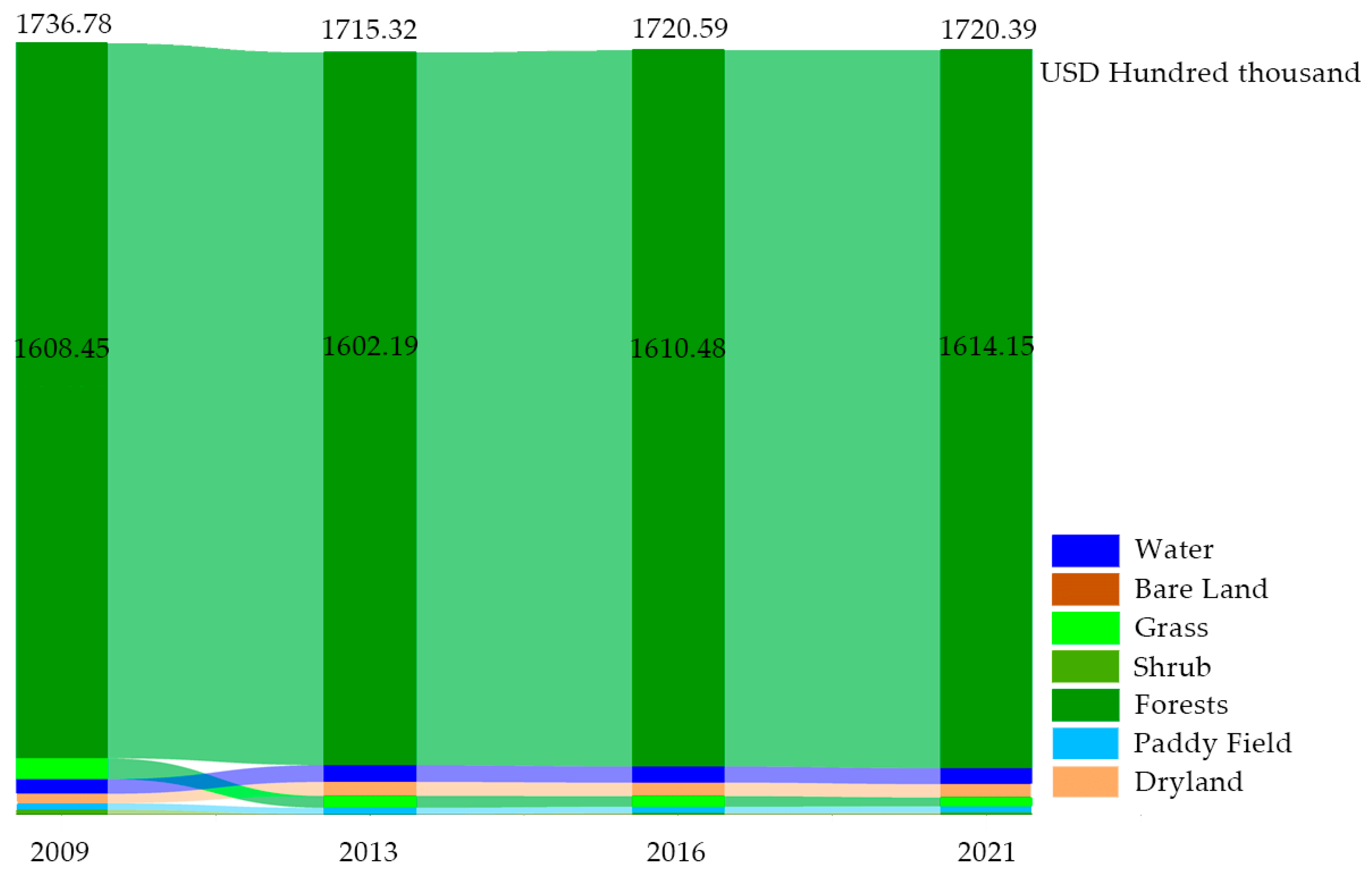
The EPV in the study area is USD 173.68, 171.53, 172.06, and 172.06 million in 2009, 2013, 2016, and 2021, respectively (Figure 4). Among all land use types in the study area, forest is the main contributor to EPV, and its contribution is gradually increasing. This may be due to the fact that the proportion of the forest area in the four periods of the study area exceeds 82%. The EPV proportion of forests in the total EPV of the study area reached 92.61%, 93.40%, 93.60%, and 93.82% in 2009, 2013, 2016, and 2021, respectively. The EPV of forests showed a downward trend before World Heritage inscription but an upward trend after the inscription, which is consistent with the trend of the proportion of the forest area. The EPV of grasslands, water, drylands, and paddy fields accounts for a small proportion of the EPV in the study area. Among them, the EPV of grassland continues to decrease, while the EPV in water and dryland shows a slow growth trend. The EPV of bare land is the lowest, accounting for less than 0.01% of the EPV in the study area.

3.2.2. Economic Value of Different Ecological Products

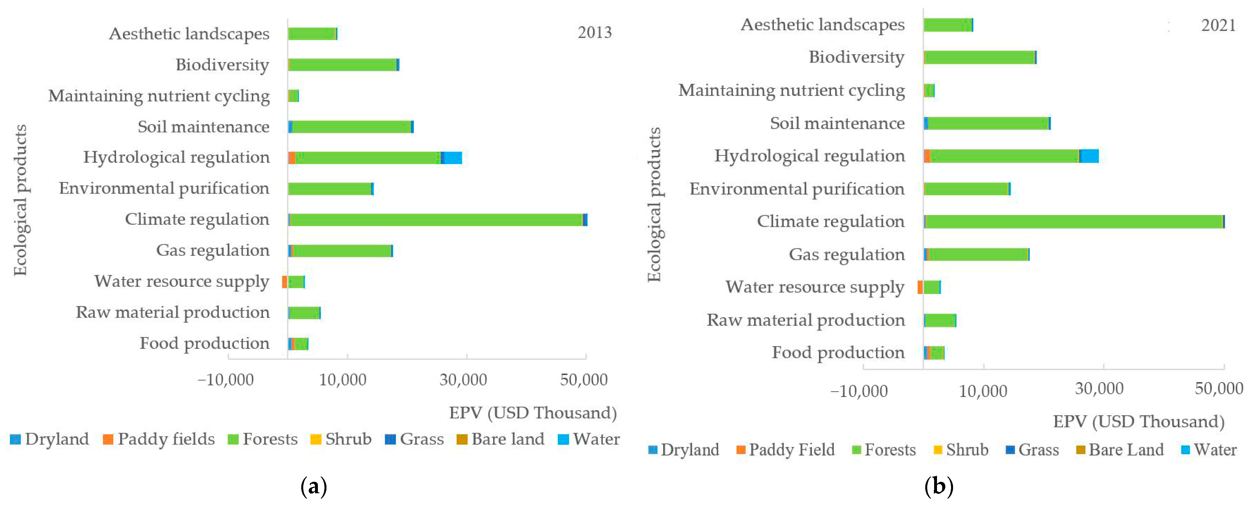
The EPV of 2013 and 2021 were taken as examples to analyze the changes in the economic value of different ecological products. From 2013 to 2021, except for a slight decrease in the economic value of food production and hydrological regulation, the value of other types of ecological products in the study area showed an increasing trend (Figure 5). The value of different types of ecological products, in descending order, is regulatory services, support services, supply services, and cultural services. Among them, regulation services contribute more than 60% of the total EPV of the study area. In terms of the source of value, the value of providing services mainly comes from forests; the value of regulatory services mainly comes from forests and water bodies; the value of support services mainly comes from forest land and farmland; the value of cultural services mainly comes from forests.
In terms of the change in the contribution rate of the total EPV, the contribution rate of supply services decreased by 0.02%, mainly reflected in the decrease of 0.02% and 0.01% in food production and water resource supply, respectively. In addition, the water consumption of paddy fields in the agricultural ecosystem has led to a negative supply of water resources, and the reduction in the paddy field area in 2021 has alleviated this phenomenon. The contribution rate of regulation services has decreased by 0.01%, mainly reflected in a decrease of 0.09% in both hydrological regulation and an increase of 0.07% and 0.01% in climate regulation and environmental purification, respectively. The contribution rate of gas regulation remains unchanged. The contribution rate of support services increased by 0.03%, mainly reflected in the increase of 0.01% and 0.02% in soil conservation and biodiversity, respectively, while the contribution rate of maintaining nutrient cycling remained unchanged. The contribution rate of cultural services has not changed.

3.2.3. Spatial Distribution of EPV

The spatial distribution of EPV has obvious hierarchical characteristics in the study area (Figure 6a). The high-value areas of ecological products are mainly distributed within the property, as well as the northern areas of Baitang Village, Baiduo Village, and Chayuan Village in the buffer zone. This is highly consistent with the distribution of forests (Figure 6b). The presence of grasslands and shrubs in some regions of the property has led to the emergence of low-EPV-value areas in the property. The population of the research area is mainly distributed in the buffer zone, resulting in the distribution pattern of dryland and paddy fields in the buffer zone. Due to the fragmentation of the karst surface, the spatial distribution of agricultural land is scattered, and the EPV grid of different ecosystems is staggered. Figure 6 indicated that the low-value areas of ecological products are generally related to the distribution of agricultural land.

3.3. Models and Paths of EPV Realization

3.3.1. The Construction of Indicator System for EPV Realization

How to establish the connection between the supply of EPV and the development demand of ecological industries to promote the value realization of ecological products is a difficult point in current theoretical and practical exploration. Taking the EPV of the study area in 2021 as an example, spatial zoning of the value realization models was constructed in this study. In 2021, the regulation service value accounted for 64.87% of the total EPV of the study area, while the support service value accounted for 24.15%. The above two value types are more abstract than cultural service (accounting for 4.78%), and it is difficult to achieve an exchange between supply and demand through real markets. Supply services (accounting for 6.20%) and cultural services represent the status of EPV realization, while regulatory services and support services reflect the potential of EPV realization.
Based on the contribution value of various land use types to the total EPV of the study area, the indicator system for the EPV realization was constructed (Table 4). Ranking the contribution value of land types from highest to lowest, it can be found that forest, farmland (dryland and paddy field), and wetland ecosystems are the top three. Therefore, ecological forestry economy, characteristic agricultural economy, and ecological water economy were chosen as the dominant models. Then, the values of forest ecosystems were ranked from highest to lowest to select the top 60% as the spatial zoning indicators of the ecological forestry economy. The same method was used to choose the spatial zoning indicators of the characteristic agricultural economy and ecological water economy.

3.3.2. Spatial Zoning of the Value Realization Models

The dominant models of EPV realization were spatially zoned based on the EPV, land use status, and limiting factors of each spatial zoning factor of dominant models. Among them, the EPV and the current status of land use have been discussed above. The main limiting factors refer to the limits on space and types of activities for heritage conservation in the study area. The regulations on the protection of Shibing Karst Natural World Heritage in Qiandongnan Miao and Dong Autonomous Prefecture (2018) classified the protection scope of the study area as a strictly protected area, heritage display area, and buffer zone. The strictly protected area is located in the central and northern regions of the property, while the exhibition area is located in the southern part of the property.
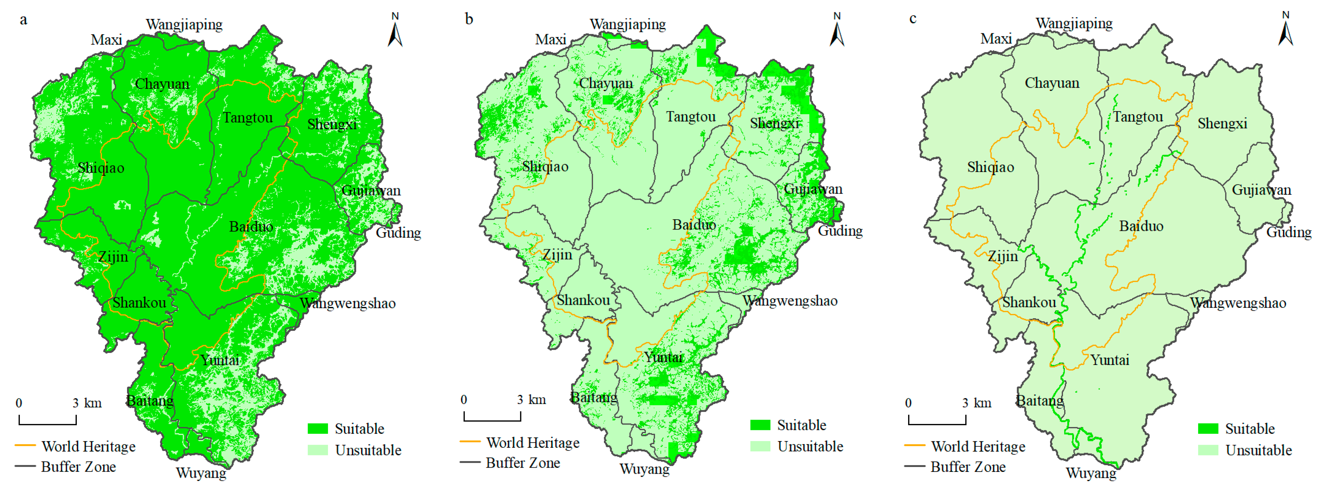
Taking the forestry economy as an example, the spatial distribution of the ecological forestry economy was obtained by using the overlay tool in ArcGIS10.8 using the total value of its spatial zoning indicators (B2, B3, C1, C3, B1, B3, and D1) and the land use data of forests (Figure 7a). The spatial distribution of the characteristic agricultural economy was obtained by using the total value of its spatial zoning indicators (B4, A1, B1, C1, B2, and A2) and the land use data of farmland (dryland and paddy field) (Figure 7b). The spatial distribution of the ecological water economy was obtained by using the total value of its spatial zoning indicators (B4, A3, B3, C3, B2, D1, and C1) and the land use data of water (Figure 7c).
The ecological forestry economy is the dominant model for realizing the EPV of the study area, mainly distributed in the property, including the west, north, and northeast of Baiduo Village, the west of Yuntai, the east of Shiqiao, and the south of Chayuan. It is also widely distributed on the side of the buffer zone near the property. The characteristic agricultural economy is distributed in the south of Yuntai Village, the east of Baiduo, the east and center of Gujiawan, the north of Shengxi and Tangtou, the center of Chayuan, and the west of Shiqiao and Zijing, all located in the buffer zone. The ecological water economy is distributed along the river, mainly located in Wuyang Village, Baitang, Shankou, Baiduo, and Tangtou. Among these areas suitable for developing an ecological water economy, the areas located in the upper reaches of the north are suitable for water conservation, while the middle and lower reaches in the south are suitable for ecotourism. The characteristic agricultural economy and ecological forestry economy are the main models in the buffer zone, followed by the water economy.
Due to the multi-purpose nature of ecological products, as well as the rugged and fragmented surface of karst mountainous areas, the spatial distribution of land types was relatively fragmented. This resulted in the possibility of multiple EPV realization models in the same region. The dominant model is not the only realization model, and it does not exclude other development methods in the region. Conducting zoning of the dominant development model is conducive to implementing a centralized and contiguous economic development layout at the village scale and conducive to efficient regional land use. Based on the spatial zoning data of the ecological forestry economy, characteristic agricultural economy, and ecological water economy, as well as the limitations for heritage conservation, the classification and paths of dominant EPV realization models were proposed (Table 5). Maxi Village, Wangjiaping Village, and Guding Village occupy a relatively small area in the buffer zone and are far from the exhibition area to the south of the property. Therefore, the dominant models of realizing the EPV of the three villages were not discussed.

4. Discussion

4.1. Factors Affecting Land Use Changes

The land use types of the study area from 2009 to 2021 were mainly forests, dryland, paddy fields, and grassland. The main land use types of the property were forests and grassland. The main land use types in the buffer zone were forests, dryland, paddy fields, and grasslands. The forests in the property showed a continuous growth trend. The forests in the buffer zone showed a downward trend before World Heritage inscription, but an increasing trend after the inscription. The area of paddy fields, shrubs, and grasslands showed a downward trend, with the area of paddy fields in the property showing a rapid decline. The conversion of land use types is weak in the property and strong in the buffer zone. The main reason may be that some residents moved out of the property and some human activities within the property were restricted for the World Heritage inscription and conservation. Rational land use plans, ecosystem service protection guidelines, such as the protection regulation on Shibing Karst Natural World Heritage Site, and ecological compensation policy play a vital role in land use management [51]. In the Kaziranga National Park, the growth of human settlements obstructs animal migration routes, while an eviction program in 2015 moving out many households around the park expanded and reclaimed more forest [52]. This also proved the importance of human activities on the impact of land use change.

4.2. The Spatiotemporal Changes of EPV

The EPV of the study area showed a downward and then an upward trend, which is similar to the other study results in karst areas in southwest China [53,54]. The forest is the main contributor to EPV, and its contribution is gradually increasing. This may be due to the fact that the proportion of the forest area in the four periods of the study area exceeds 82%. The EPV of forests showed a downward trend before World Heritage inscription but an upward trend after the inscription, which is consistent with the trend of the proportion of the forest area. The spatial distribution of ecosystem service value of the study area has obvious hierarchical characteristics. World Heritage inscription is beneficial for maintaining the stability of land use and the improvement of EPV in the property. The high- and low-EPV areas may be, respectively, related to the distribution of forests and agricultural land.

4.3. EPV Realization Models

The natural environment of karst protected areas is complex. To objectively analyze the realization models and paths of EPV, this study proposes a spatial zoning method for the value realization models of ecological products based on EPV. This method takes into account the integrity of geomorphic units, the necessity of an outstanding universal value of the property, and the limitations of existing land resource development intensity. The dominant models of EPV in the study area are ecological forestry economy, water economy, and ecological agricultural economy and forestry economy. The EPV realization model is dynamically influenced by factors such as land use changes, government decisions, the development of the heritage tourism industry, the homestay economy, and the development of an understory economy. However, due to its multiple protection titles, nature conservation has always been given priority. We are trying to find possible synergistic mechanisms between ecological protection and the improvement of human well-being.

4.4. Implications for Other Protected Areas

How to transform the lucid waters and lush mountains into invaluable assets, provide more ecological products, and achieve the sustainable conversion of natural wealth and economic value are major issues that need to be urgently solved [55,56]. This study explored the spatiotemporal changes in land use of a karst World Heritage property and further analyzed the spatiotemporal changes in EPV. Tourism and production activities within the buffer zone have caused some ecological protection pressure on the property. It is recommended to pay more attention to the impact assessment of human activities [57], especially tourism activities, which adds pressure for many properties.
Firstly, the boundary delimitation of karst protected areas mainly considers the relative integrity of physical geography units and often breaks the administrative boundaries in space. This makes it difficult to form a standard unified standard for socio-economic statistics, and there are great obstacles in data collection. It is necessary to build a socio-economic statistical standard suitable for karst protection. Secondly, due to differences in the natural environment and socio-economic development, there are differences in the attributes, quantity, structure, and industrial development models of EPV among different types of karst protected areas. Furthermore, in the process of transforming ecological products into ecological industries, the government needs to play a guiding role. On the basis of leveraging the advantages of the local natural environment and ethnic customs, they can provide technical training for community residents. Stakeholders should be involved in decision making as the main force in heritage protection and the realization of ecological product value.
Though this methodology is easy to adopt and cost-effective, there are a few limitations. Karst groundwater (the water in a karst aquifer) is a major water resource for most of the settlements in the karstic regions [58]. Because the land use data come from remote sensing images, groundwater is inevitably missed out in calculations and analysis. This may lead to a lower water area and lower EPV. In this study, the implementation of ground-penetrating radar detection and groundwater models could be effective means to improve research accuracy in karst areas [59].

5. Conclusions

World Heritage inscription and conservation contribute to maintaining the relatively stable land use types and areas. From 2009 to 2021, the forest land area in the study area showed an increasing trend during the four periods, increasing from 82.10% to 82.72%. In the property, the proportion of forest land area continued to increase, which is 96.66%, 97.09%, 97.37%, and 97.53% in 2009, 2013, 2016, and 2021, respectively. In the buffer zone, there were fluctuations in the change in forest land area, with the proportion in the four periods being 74.29%, 73.54%, 74.05%, and 74.25%, respectively. The grassland area in the study area showed a decreasing trend, while the dryland and construction land area showed an increasing trend. Dryland, paddy fields, and construction land are mainly distributed in buffer zones, and the frequency of land type conversion is relatively high. Based on the need for heritage conservation, human farming activities are reduced, and construction activities are strictly controlled within the property. Paddy fields are reduced from 0.44% to 0.31%, and the proportion of construction land remains around 0.04%.
World Heritage inscription and conservation have also promoted the stability of the ecosystem and the enhancement of EPV in the study area. In the years 2009, 2013, 2016, and 2021, the proportion of forest EPV in the study area exceeded 92%. The reason for the significant contribution of forest EPV to the overall region may be that the proportion of the forest area in the study area exceeded 82%. During the four periods, the total EPV of the property showed a continuous and stable growth trend, which was USD 70.61 million, USD 71.04 million, USD 71.03 million, and USD 71.13 million in 2009, 2013, 2016, and 2021, respectively.
The study proposed a spatial zoning method for the value realization models of ecological products based on EPV. Based on the contribution value of various land use types to the EPV, the limitation factors of heritage conservation, and land use conditions of the property and buffer zones, the dominant models for the value realization of ecological products are divided into three types. They are the ecological forestry economy, characteristic agricultural economy, and ecological water economy. The dominant models for realizing the EPV of the property in the study area are the ecological forestry economy and water economy. The dominant models in the buffer zone include the characteristic agricultural economy, ecological forestry economy, and water economy.

Author Contributions

All authors contributed to the manuscript. Conceptualization, K.X. and Z.Z.; methodology, Z.Z.; validation, D.H.; formal analysis, Z.Z.; data curation, D.H.; writing—original draft preparation, Z.Z.; writing—review and editing, Z.Z., K.X., D.H., W.Z. and H.C.; visualization, Z.Z. and D.H.; project administration, K.X.; funding acquisition, K.X. All authors have read and agreed to the published version of the manuscript.

Funding

This research was funded by Guizhou Provincial Key Technology R&D Program (grant no. 220 2023 QKHZC), the Key Project of Science and Technology Program of Guizhou Province (grant no. 5411 2017 QKHPTRC), and the China Overseas Expertise Introduction Program for Discipline Innovation (grant no. D17016).

Data Availability Statement

All the data used in this study are mentioned in Section 2 “Materials and Methods”.

Acknowledgments

The authors gratefully acknowledge the financial support of Guizhou Normal University. We would also like to thank the editors and anonymous reviewers for their helpful and productive comments on the manuscript.

Conflicts of Interest

The authors declare no conflict of interest. The funders had no role in the design of the study; in the collection, analyses, or interpretation of data; in the writing of the manuscript; or in the decision to publish the results.

References

  1. Daily, G.C.; Soderqvist, T.; Aniyar, S.; Arrow, K.; Dasgupta, P.; Ehrlich, P.R.; Folke, C.; Jansson, A.; Jansson, B.O.; Kautsky, N.; et al. The value of nature and the nature of value. Science 2000, 289, 395–396. [Google Scholar] [CrossRef] [PubMed]
  2. Xie, G.D. Mechanism for realizing the value of ecosystem services. Environ. Prot. 2012, 17, 16–18. [Google Scholar] [CrossRef]
  3. Ministry of Ecology and Environment of the People’s Republic of China Has Issued the “Technical Guidelines for Calculating Gross Ecosystem Product of Terrestrial Ecosystems”. Available online: http://www.caep.org.cn/zclm/sthjyjjhszx/zxdt_21932/202010/t20201029_805419.shtml (accessed on 29 October 2020).
  4. Ouyang, Z.Y.; Song, C.S.; Zheng, H.; Polasky, S.; Xiao, Y.; Bateman, I.J.; Liu, J.G.; Ruckelshaus, M.; Shi, F.Q.; Xiao, Y.; et al. Using gross ecosystem product (GEP) to value nature in decision making. Proc. Natl. Acad. Sci. USA 2020, 117, 14593–14601. [Google Scholar] [CrossRef] [PubMed]
  5. Zhang, L.B.; Yu, H.Y.; Hao, C.Z.; Wang, H.; Luo, R.J. Redefinition and connotation analysis of ecosystem product. Res. Environ. Sci. 2021, 34, 655–660. [Google Scholar] [CrossRef]
  6. Ouyang, Z.Y.; Lin, Y.Q.; Song, C.S. Research on gross ecosystem product(GEP): Case study of Lishui City, Zhejiang Province. Environ. Sustain. Dev. 2020, 45, 80–85. [Google Scholar] [CrossRef]
  7. Lin, A.; Shen, Y.Q.; Xiao, Y.; Ouyang, Z.Y. Research on accounting of ecological products value in national parks. Acta Ecol. Sin. 2023, 43, 208–218. [Google Scholar]
  8. Lin, Y.Q.; Xu, W.H.; Li, P.; Wang, X.K.; Ouyang, Z.Y. Assessing the realization of values of ecosystem products: A case study of Li shui, China. Acta Ecol. Sin. 2023, 43, 189–197. [Google Scholar]
  9. Daily, G.C.; Ruckelshaus, M. 25 years of valuing ecosystems in decisions. Nature 2022, 606, 465–466. [Google Scholar] [CrossRef]
  10. System of Environmental-Economic Accounting—Ecosystem Accounting (SEEA EA). Available online: https://seea.un.org/ecosystem-accounting (accessed on 29 September 2021).
  11. Ouyang, Z.Y.; Zhu, C.Q.; Yang, G.B.; Xu, W.H.; Zheng, H.; Zhang, Y.; Xiao, Y. Gross ecosystem product: Concept, accounting framework and case study. Acta Ecol. Sin. 2013, 33, 6747–6761. [Google Scholar] [CrossRef]
  12. Robertson, G.P.; Swinton, S.M. Reconciling agricultural productivity and environmental integrity: A grand challenge for agriculture. Front. Ecol. Environ. 2005, 3, 38–46. [Google Scholar] [CrossRef]
  13. Kareiva, P.; Marvier, M. Conserving biodiversity coldspots—Recent calls to direct conservation funding to the world’s biodiversity hotspots may be bad investment advise. Am. Sci. 2003, 91, 344–351. [Google Scholar] [CrossRef]
  14. Zhang, B.A.; Li, W.H.; Xie, G.D. Ecosystem services research in China: Progress and perspective. Ecol. Econ. 2010, 69, 1389–1395. [Google Scholar] [CrossRef]
  15. Yu, Z.Y.; Bi, H. The key problems and future direction of ecosystem services research. In Proceedings of the International Conference on Energy, Environment and Development (ICEED), Kuala Lumpur, Malaysia, 8–9 December 2010; Elsevier Science Bv.: Amsterdam, The Netherlands, 2010. [Google Scholar]
  16. Costanza, R.; dArge, R.; deGroot, R.; Farber, S.; Grasso, M.; Hannon, B.; Limburg, K.; Naeem, S.; Oneill, R.V.; Paruelo, J.; et al. The value of the world’s ecosystem services and natural capital. Nature 1997, 387, 253–260. [Google Scholar] [CrossRef]
  17. Xie, G.D.; Zhen, L.; Lu, C.X.; Xiao, Y.; Chen, C. Expert knowledge based valuation method of ecosystem services in China. J. Nat. Resour. 2008, 23, 911–919. [Google Scholar]
  18. Wang, W.J.; Guo, H.C.; Chuai, X.W.; Dai, C.; Lai, L.; Zhang, M. The impact of land use change on the temporospatial variations of ecosystems services value in China and an optimized land use solution. Environ. Sci. Policy 2014, 44, 62–72. [Google Scholar] [CrossRef]
  19. Costanza, R.; de Groot, R.; Sutton, P.; van der Ploeg, S.; Anderson, S.J.; Kubiszewski, I.; Farber, S.; Turner, R.K. Changes in the global value of ecosystem services. Glob. Environ. Chang. 2014, 26, 152–158. [Google Scholar] [CrossRef]
  20. Li, L.; Qian, Y.C.; Yan, W.D. Research on the evaluation index system for ecological civilizaion construction in major function zoning. J. Cent. South Univ. For. Technol. Soc. Sci. 2021, 15, 1–8. [Google Scholar] [CrossRef]
  21. Transforming Our World: The 2030 Agenda for Sustainable Development. Available online: https://sdgs.un.org/2030agenda (accessed on 21 October 2015).
  22. Xiao, J.; Xiong, K.N. A review of agroforestry ecosystem services and its enlightenment on the ecosystem improvement of rocky desertification control. Sci. Total Environ. 2022, 852, 17. [Google Scholar] [CrossRef]
  23. Xu, G.Y.; Xiao, J.; Oliver, D.M.; Yang, Z.Q.; Xiong, K.N.; Zhao, Z.M.; Zheng, L.L.; Fan, H.X.; Zhang, F.X. Spatio-temporal characteristics and determinants of anthropogenic nitrogen and phosphorus inputs in an ecologically fragile karst basin: Environmental responses and management strategies. Ecol. Indic. 2021, 133, 16. [Google Scholar] [CrossRef]
  24. Pei, J.; Wang, L.; Huang, H.B.; Wang, L.; Li, W.; Wang, X.Y.; Yang, H.; Cao, J.H.; Fang, H.J.; Niu, Z. Characterization and attribution of vegetation dynamics in the ecologically fragile South China Karst: Evidence from three decadal Landsat observations. Front. Plant Sci. 2022, 13, 15. [Google Scholar] [CrossRef]
  25. Pang, D.B.; Cao, J.H.; Dan, X.Q.; Guan, Y.H.; Peng, X.W.; Cui, M.; Wu, X.Q.; Zhou, J.X. Recovery approach affects soil quality in fragile karst ecosystems of southwest China: Implications for vegetation restoration. Ecol. Eng. 2018, 123, 151–160. [Google Scholar] [CrossRef]
  26. Zhang, S.H.; Xiong, K.N.; Deng, X.H.; Kong, L.W.; Min, X.Y. Impact of ecological restoration on ecosystem service trade-offs: Insight from karst desertification control. Land Degrad. Dev. 2023, 34, 2693–2706. [Google Scholar] [CrossRef]
  27. Jiang, Y.; Gao, J.B.; Wu, S.H.; Jiao, K.W. Mediation effect as the component to ecosystem? Establishing the chain effect framework of ecosystem services across typical karst basin in China. Catena 2023, 221, 10. [Google Scholar] [CrossRef]
  28. Xiong, K.N.; Li, J.; Long, M.Z. Features of soil and water loss and key issues in demonstration areas for combating karst rocky desertification. Acta Geogr. Sin. 2012, 67, 878–888. [Google Scholar]
  29. Zhang, Z.Z.; Xiong, K.N.; Chang, H.H.; Zhang, W.X.; Huang, D.H. A review of eco-product value realization and ecological civilization and its enlightenment to karst protected areas. Int. J. Environ. Res. Public Health 2022, 19, 5892. [Google Scholar] [CrossRef]
  30. Guo, X.J.; Jiang, G.H.; Gong, X.P.; Yin, J.J.; Wu, X. Recharge processes on typical karst slopes implied by isotopic and hydrochemical indexes in Xiaoyan Cave, Guilin, China. J. Hydrol. 2015, 530, 612–622. [Google Scholar] [CrossRef]
  31. Zhang, L.M.; Wu, Y.N.; Yan, L.B.; Wang, Y.; Chen, J.; Yu, L.F. Modeling the maximal organic carbon saturation capacity in karst forest soils of China: Comparing the existing models. Appl. Ecol. Environ. Res. 2021, 19, 4115–4128. [Google Scholar] [CrossRef]
  32. Fang, Q.; Zhao, L.S.; Hou, R.; Fan, C.H.; Zhang, J.X. Rainwater transformation to runoff and soil loss at the surface and belowground on soil-mantled karst slopes under rainfall simulation experiments. Catena 2022, 215, 9. [Google Scholar] [CrossRef]
  33. Fan, C.H.; Zhao, L.S.; Hou, R.; Fang, Q.; Zhang, J.X. Quantitative analysis of rainwater redistribution and soil loss at the surface and belowground on karst slopes at the microplot scale. Catena 2023, 227, 10. [Google Scholar] [CrossRef]
  34. Yan, Y.J.; Dai, Q.H.; Yang, Y.Q.; Lan, X. Effects of vegetation restoration types on soil erosion reduction of a shallow karst fissure soil system in the degraded karst areas of Southwestern China. Land Degrad. Dev. 2023, 34, 2241–2255. [Google Scholar] [CrossRef]
  35. Guo, Y.; Du, X.Y.; Li, D.D.; Zheng, G.D.; Zhang, X.Y.; Chen, H.K.; Zheng, J. How newly developed shale gas facilities influence soil erosion in a karst region in SW China. Sci. Total Environ. 2022, 818, 8. [Google Scholar] [CrossRef]
  36. Yang, Y.; Xiong, K.N.; Huang, H.Q.; Xiao, J.; Yang, B.L.; Zhang, Y. A commented review of eco-product value realization and ecological industry and its enlightenment for agroforestry ecosystem services in the karst ecological restoration. Forests 2023, 14, 448. [Google Scholar] [CrossRef]
  37. Sun, B.W.; Peng, X.S. Ecological product value realization models, key issues, and institutional guarantee system. Ecol. Econ. 2021, 37, 13–19. [Google Scholar]
  38. Qiu, S.L.; Jin, L.S. Realizing the value of ecological products: Theoretical basis, basic logic, and main models. Agric. Econ. 2021, 408, 106–108. [Google Scholar]
  39. Fang, M. Zhejiang model and experience of realizing ecological product value. Environ. Prot. 2020, 48, 25–27. [Google Scholar] [CrossRef]
  40. Zhang, L.B.; Yu, H.Y.; Hao, C.Z.; Wang, H. Practice model and path of ecosystem product value realization. Res. Environ. Sci. 2021, 34, 1407–1416. [Google Scholar] [CrossRef]
  41. Ye, Y.H.; Xiao, B.; Feng, H.J.; He, Y.L.; Chen, P.; Chen, X.Y.; Wang, D.D.; Zeng, Z.X.; Guo, X. Researches on the pattern and route of ecological product value realization from the perspective of rural revitalization. Ecol. Environ. Sci. 2022, 31, 421–428. [Google Scholar] [CrossRef]
  42. Xie, H.L.; Chen, Q.R. The connotation, goal and mode of realizing the value of ecological products. Econ. Geogr. 2022, 42, 147–154. [Google Scholar] [CrossRef]
  43. Wang, H.; Li, Q.; Wen, Y.L. The logic and modes of the realization mechanism of ecological product values: A theoretical analysis based on the excludability. China Land Sci. 2022, 36, 79–85. [Google Scholar]
  44. Wang, G.H. Suitability evaluation of ecological product development in Pizhou. J. Zhejiang Agric. Sci. 2023, 64, 992–1003. [Google Scholar] [CrossRef]
  45. Wu, S.H.; Hou, X.R.; Peng, M.X.; Cheng, M.; Xue, J.B.; Bao, H.J. Suitability assessment and zoning of value realization for ecological regulation services: A case study of Lishui city, Zhejiang province. China Land Sci. 2021, 35, 81–89. [Google Scholar]
  46. Xie, G.D.; Lu, C.X.; Leng, Y.F.; Zheng, D.; Li, S.C. Ecological assets valuation of the Tibetan Plateau. J. Nat. Resour. 2003, 18, 189–196. [Google Scholar]
  47. Peng, W.F.; Zhou, J.M.; Yang, C.J.; Zhao, J.F.; Luo, H.L. Research on ecosystem services value based on land use change in Sichuan Province. Resour. Environ. Yangtze Basin 2014, 23, 1053–1062. [Google Scholar]
  48. Wang, Z.F.; Xu, J. Impacts of land use evolution on ecosystem service value of national parks: Take Sanjiangyuan National Park as an example. Acta Ecol. Sin. 2022, 42, 6948–6958. [Google Scholar]
  49. Xie, G.D.; Zhang, C.X.; Zhang, L.M.; Chen, W.H.; Li, S.M. Improvement of the evaluation method for ecosystem service value based on per unit area. J. Nat. Resour. 2015, 30, 1243–1254. [Google Scholar]
  50. Ning, L.M.; Wang, X.L. Changes of ecosystem services value in Wuhan city. Ecol. Environ. Sci. 2006, 15, 637–640. [Google Scholar] [CrossRef]
  51. Mwabumba, M.; Yadav, B.K.; Rwiza, M.J.; Larbi, I.; Twisa, S. Analysis of land use and land-cover pattern to monitor dynamics of Ngorongoro world heritage site (Tanzania) using hybrid cellular automata-Markov model. Curr. Res. Environ. Sustain. 2022, 4, 100126. [Google Scholar] [CrossRef]
  52. Nath, N.; Sahariah, D.; Meraj, G.; Debnath, J.; Kumar, P.; Lahon, D.; Chand, K.; Farooq, M.; Chandan, P.; Singh, S.K.; et al. Land use and land cover change monitoring and prediction of a UNESCO world heritage site: Kaziranga eco-sensitive zone using Cellular Automata-Markov model. Land 2023, 12, 151. [Google Scholar] [CrossRef]
  53. Chi, Y.; He, C. Impact of land use change on the spatial and temporal evolution of ecosystem service values in South China Karst areas. Forests 2023, 14, 893. [Google Scholar] [CrossRef]
  54. Chen, W.; Zhang, X.; Huang, Y. Spatial and temporal changes in ecosystem service values in karst areas in southwestern China based on land use changes. Environ. Sci. Pollut. Res. 2021, 28, 45724–45738. [Google Scholar] [CrossRef] [PubMed]
  55. Zhang, Z.Z.; Xiong, K.N.; Huang, D.H. Natural world heritage conservation and tourism: A review. Herit. Sci. 2023, 11, 55. [Google Scholar] [CrossRef]
  56. Yang, B.L.; Zhang, Y.; Xiong, K.N.; Huang, H.Q.; Yang, Y. A review of eco-product value realization and eco-industry with enlightenment toward the forest ecosystem services in karst ecological restoration. Forests 2023, 14, 729. [Google Scholar] [CrossRef]
  57. Zhang, J.; Xiong, K.N.; Liu, Z.J.; He, L.X. Research progress on world natural heritage conservation: Its buffer zones and the implications. Herit. Sci. 2022, 10, 42. [Google Scholar] [CrossRef]
  58. Kacaroglu, F. Review of groundwater pollution and protection in karst areas. Water Air Soil Pollut. 1999, 113, 337–356. [Google Scholar] [CrossRef]
  59. Honings, J.P.; Wicks, C.M.; Brantley, S.T. Ground-penetrating radar detection of hydrologic connectivity in a covered karstic setting. Hydrology 2022, 9, 168. [Google Scholar] [CrossRef]
Figure 1. Location of the study area.
Forests 14 01449 g001
Figure 2. Change in area proportion of different land use types.
Forests 14 01449 g002
Figure 3. Spatial distribution of the transformation of land use types. (a) Transformation of land use types from 2009 to 2013 before World Heritage inscription; (b) Transformation of land use types from 2013 to 2016 before and after the inscription; and (c) Transformation of land use types from 2016 to 2021 after the inscription.
Forests 14 01449 g003
Figure 4. Changes in EPV of different land use types.
Forests 14 01449 g004
Figure 5. Economic value of ecological products in 2013 and 2021. (a) Economic value of ecological products in 2013; (b) Economic value of ecological products in 2021.
Forests 14 01449 g005
Figure 6. Spatial distribution of EPV and land use types in 2021. (a) Spatial distribution of EPV in 2021; (b) The distribution of land use types in 2021.
Forests 14 01449 g006
Figure 7. Spatial division of EPV realization models. (a) Spatial suitability of ecological forestry economy; (b) Spatial suitability of characteristic agricultural economy; (c) Spatial suitability of ecological water economy.
Forests 14 01449 g007
Table 1. Planting area, yield, and unit price (2018 USD) of main grain crops in Shibing County.
Crop TypesPlanting Area (ha)Yield (kg/ha)Price (USD kg−1)
Grains6520.345897.700.54
Beans734.331266.451.12
Potatoes5166.744148.070.19
Table 2. Revised ecological product value (2018 USD ha−1 yr−1) of different land use types.
Service TypesEcological ProductsDrylandPaddy FieldForestsShrubGrassBare LandWater
Supply Services
(A)
Food Production (A1)254.11406.5792.6756.8065.770.00239.16
Raw Material Production (A2)119.5826.91212.25128.55128.550.0068.76
Water Supply (A3)5.98−786.24110.6165.7753.810.002478.30
Regulation Services (B)Gas Regulation (B1)200.30331.83702.53421.52340.805.98230.19
Climate Regulation (B2)107.62170.402101.621264.56902.830.00684.60
Purifying Environment (B3)29.9050.82594.91382.66298.9529.901659.17
Hydrological Regulation (B4)80.72813.141049.311001.48660.688.9730,564.65
Support Services
(C)
Soil Conservation (C1)307.922.99855.00514.19415.545.98278.02
Maintain Nutrient Cycling (C2)35.8756.8065.7738.8632.880.0020.93
Biodiversity (C3)38.8662.78777.27469.35379.675.98762.32
Cultural services (D)Aesthetic Landscape (D1)17.9426.91340.80206.28167.412.99565.02
Table 3. Main land type characteristics of different grid sizes.
Land Types1000 m500 m250 m
FarmlandForests 14 01449 i001Forests 14 01449 i002Forests 14 01449 i003
GrassForests 14 01449 i004Forests 14 01449 i005Forests 14 01449 i006
ForestsForests 14 01449 i007Forests 14 01449 i008Forests 14 01449 i009
WaterForests 14 01449 i010Forests 14 01449 i011Forests 14 01449 i012
Construction landForests 14 01449 i013Forests 14 01449 i014Forests 14 01449 i015
Table 4. The indicator system for EPV realization of the study area.
Dominant ModelsSpatial Zoning Indicators Contribution Values of Land Types
(USD Thousand)
Values of Forest Ecosystem
(USD Thousand)
Values of Farmland Ecosystem
(USD Thousand)
Values of Wetland Ecosystem
(USD Thousand)
Ecological Forestry EconomyB2, B3, C1, C3, B1, B3, D1Values
From
high
to
low
Forests (161,415.65)B2 (49,144.74)B4 (1169.70)B4 (2915.89)
Water (3582.40)B4 (24,537.42)A1 (1114.10)A3 (236.43)
Dryland (2968.24)C1 (19,993.45)B1 (891.72)B3 (158.29)
Grassland (2029.83)C3 (18,175.86)C1 (765.98)C3 (72.73)
Characteristic Agricultural EconomyB4, A1, B1, C1, B2, A2Paddy Field (1387.02)B1 (16,428.18)B2 (469.72)B2 (65.31)
Shrub (655.53)B3 (13,911.53)A2 (328.17)D1 (53.90)
Bare Land (0.56)D1 (7969.42)C3 (171.11)C1 (26.52)
A2 (4963.41)C2 (156.57)A1 (22.82)
Ecological Water EconomyB4, A3, B3, C3, B2, D1, C1 A1 (2167.12)B3 (134.64)B1 (21.96)
A3 (2586.57)D1 (76.50)A2 (6.56)
C2 (1537.96)A3 (−922.95)C2 (2.00)
Table 5. Classification and paths of dominant EPV realization models.
Dominant ModelsSpatial Distribution in VillagesThe Property/
Buffer Zone
Characteristics and Realization Paths
Ecological Forestry EconomyThe west, north, and northeast of Baiduo Village; the west of Yuntai; the east of Shiqiao; the south and north of Chayuan; and the south of TangtouMainly in the property, followed by buffer zone Products trading of planting and breeding under forests, forest land circulation and forest rights trading, forest carbon sink trading, leisure tourism, and so on.
Characteristic Agricultural EconomyThe south of Yuntai Village; the east of Baiduo; the east and center of Gujiawan; the north of Shengxi and Tangtou; the center of Chayuan; and the west of Shiqiao and ZijingBuffer zoneThe characteristics of mountainous cultivated land are obvious and widely distributed, making it suitable for mountainous high-quality agriculture, farmhouse entertainment, leisure agriculture, and so on
Ecological Water EconomyWuyang Village; Baitang; Shankou; Baiduo; and TangtouThe property and buffer zoneBasin ecological compensation, water bank, river tourism development, and so on
Disclaimer/Publisher’s Note: The statements, opinions and data contained in all publications are solely those of the individual author(s) and contributor(s) and not of MDPI and/or the editor(s). MDPI and/or the editor(s) disclaim responsibility for any injury to people or property resulting from any ideas, methods, instructions or products referred to in the content.