Estimation of Aboveground Biomass of Individual Trees by Backpack LiDAR Based on Parameter-Optimized Quantitative Structural Models (AdQSM)
Abstract
1. Introduction
2. Materials and Methods
2.1. Study Area
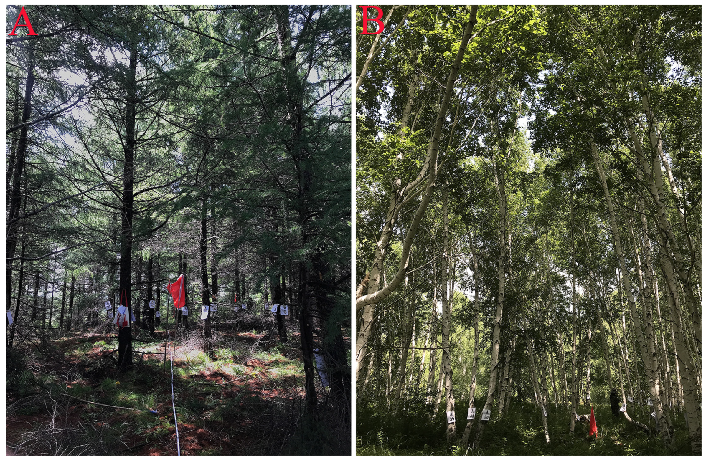
2.2. Data
2.2.1. Field Data
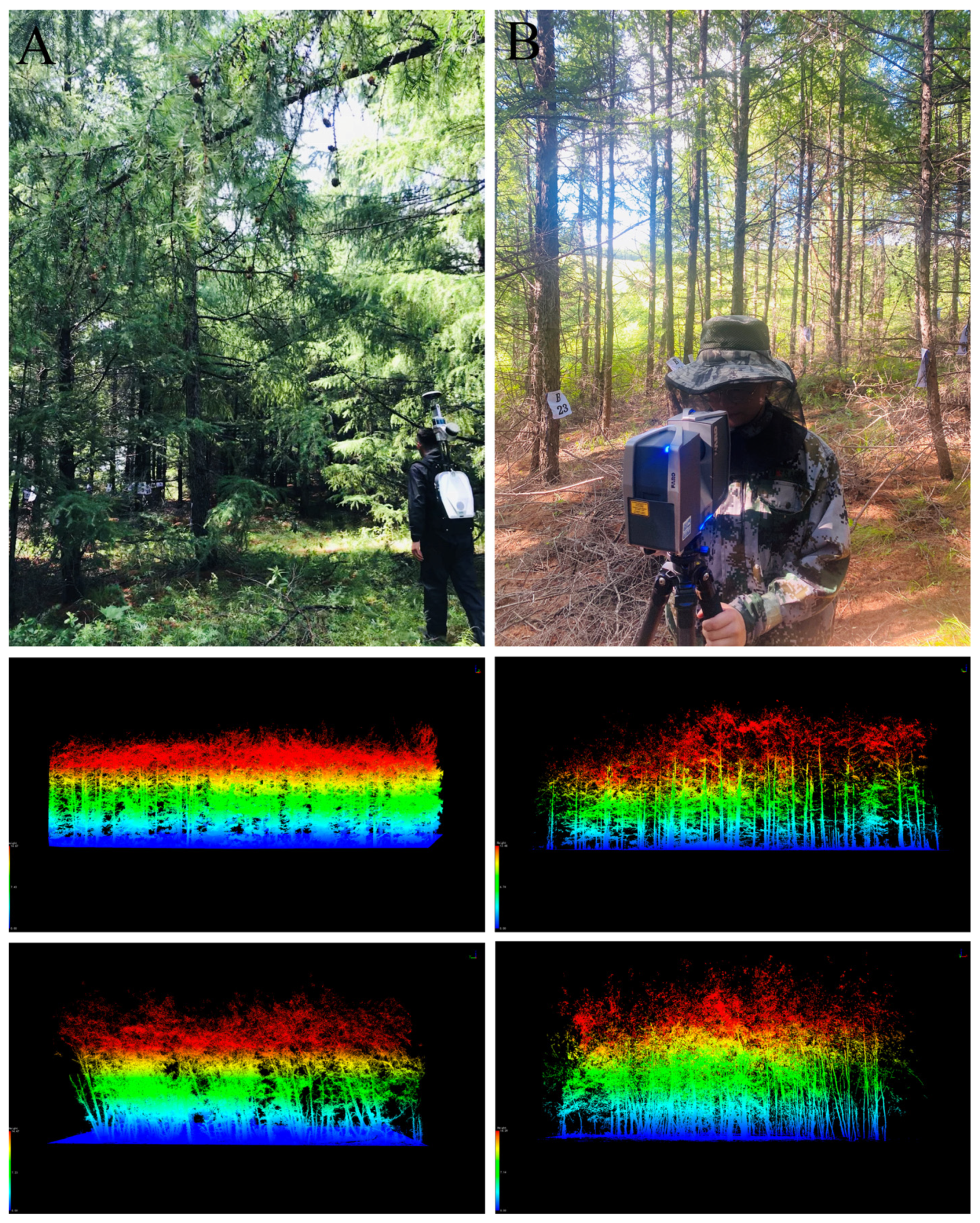
2.2.2. Backpack LiDAR Data
2.2.3. TLS Data
2.2.4. Point Cloud Data
2.3. Methods
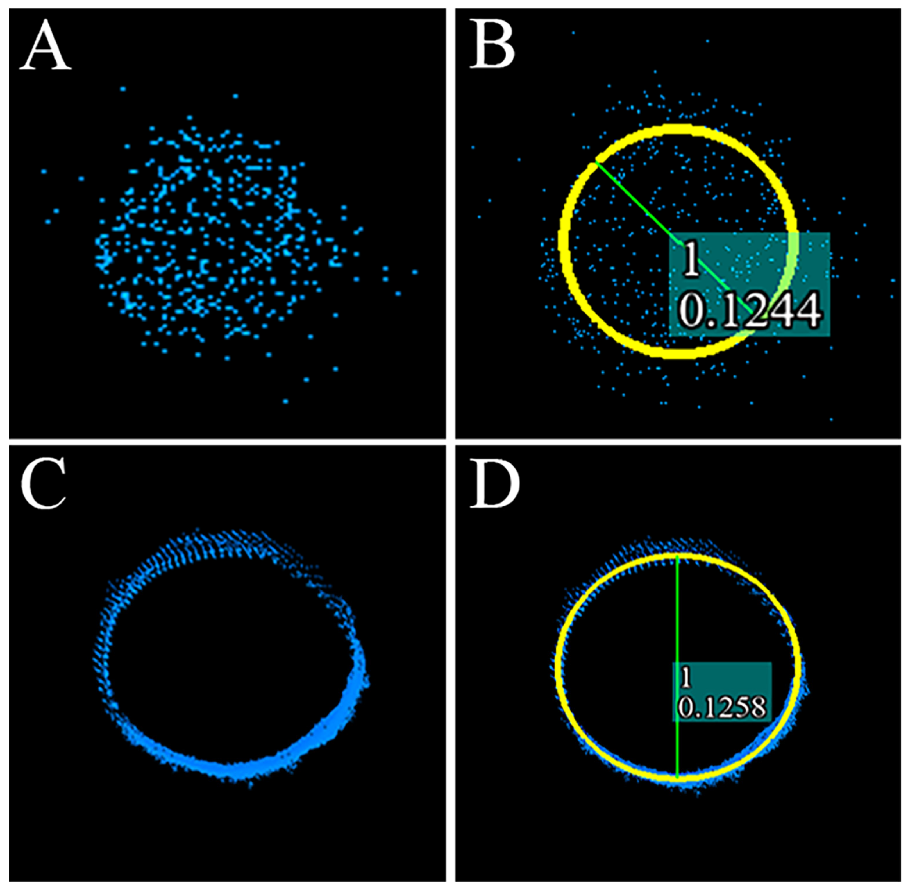
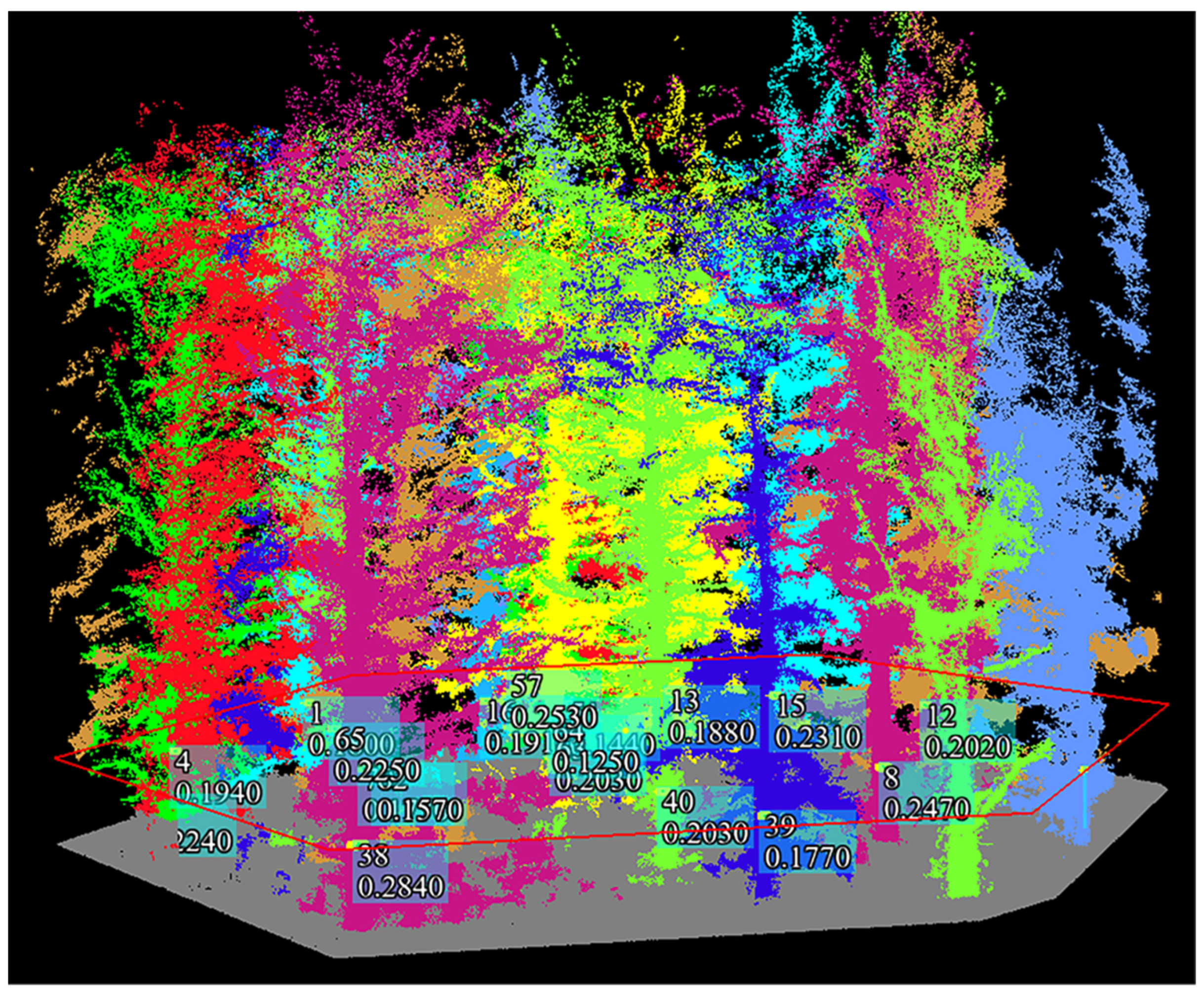
2.3.1. Individual Tree Segmentation and Parameter Extraction
2.3.2. AdQSM Reconstruction Method for Individual Trees
2.3.3. AdQSM Parameter Optimization
2.3.4. Estimation of AGB
3. Results
3.1. Accuracy Assessment of LiDAR-Extracted DBH and Tree Height
3.2. AdQSM Parameter Optimization Results
3.3. Estimation of Aboveground Biomass
4. Discussion
5. Conclusions
- (1)
- Compared with manual survey methods and TLS technology, backpack LiDAR can provide a more efficient way of acquiring data for forest inventory. This enables large-scale inventories of forest resources and further development of forest management plans;
- (2)
- Backpack LiDAR can accurately measure the canopy understory structural parameters, where DBH measurement accuracy is the highest and comparable to TLS accuracy, while backpack LiDAR-extracted tree height values are less correlated with the actual measured data;
- (3)
- Using individual tree point cloud data of Larix gmelinii and Betula platyphylla species, the HS parameters in the AdQSM reconstruction model were optimized, and after testing different parameter values, HS = 0.4 m and HS = 0.6 m were defined as the optimal parameter values applicable to Larix gmelinii and Betula platyphylla species;
- (4)
- The AGB of individual trees estimated based on the backpack–AdQSM method correlated well with the AGB of individual trees calculated by the allometric biomass models. This indicates that the backpack–AdQSM method effectively accounts for the biophysical structure of individual trees and is suitable for the accurate estimation of individual tree AGB. This nondestructive estimation method can be further used to test and calibrate new allochthonous growth models and provide a valuable reference for the accurate estimation of carbon stocks in temperate natural forest ecosystems.
Author Contributions
Funding
Data Availability Statement
Acknowledgments
Conflicts of Interest
References
- Tian, X.; Su, Z.; Chen, E.; Li, Z.; van der Tol, C.; Guo, J.; He, Q. Estimation of forest above-ground biomass using multi-parameter remote sensing data over a cold and arid area. Int. J. Appl. Earth Obs. Geoinf. 2012, 14, 160–168. [Google Scholar] [CrossRef]
- Tsui, O.W.; Coops, N.C.; Wulder, M.A.; Marshall, P.L. Integrating airborne LiDAR and space-borne radar via multivariate kriging to estimate above-ground biomass. Remote Sens. Environ. 2013, 139, 340–352. [Google Scholar] [CrossRef]
- He, Q.-S.; Cao, C.-X.; Chen, E.-X.; Sun, G.-Q.; Ling, F.-L.; Pang, Y.; Zhang, H.; Ni, W.-J.; Xu, M.; Li, Z.-Y.; et al. Forest stand biomass estimation using ALOS PALSAR data based on LiDAR-derived prior knowledge in the Qilian Mountain, western China. Int. J. Remote Sens. 2011, 33, 710–729. [Google Scholar] [CrossRef]
- Popescu, S.C. Estimating biomass of individual pine trees using airborne lidar. Biomass Bioenergy 2007, 31, 646–655. [Google Scholar] [CrossRef]
- Feliciano, E.A.; Wdowinski, S.; Potts, M.D. Assessing Mangrove Above-Ground Biomass and Structure using Terrestrial Laser Scanning: A Case Study in the Everglades National Park. Wetlands 2014, 34, 955–968. [Google Scholar] [CrossRef]
- Olschofsky, K.; Mues, V.; Köhl, M. Operational assessment of aboveground tree volume and biomass by terrestrial laser scanning. Comput. Electron. Agric. 2016, 127, 699–707. [Google Scholar] [CrossRef]
- Zimbres, B.; Shimbo, J.; Bustamante, M.; Levick, S.; Miranda, S.; Roitman, I.; Silvério, D.; Gomes, L.; Fagg, C.; Alencar, A. Savanna vegetation structure in the Brazilian Cerrado allows for the accurate estimation of aboveground biomass using terrestrial laser scanning. For. Ecol. Manag. 2020, 458, 117798. [Google Scholar] [CrossRef]
- Ghimire, S.; Xystrakis, F.; Koutsias, N. Using Terrestrial Laser Scanning to Measure Forest Inventory Parameters in a Mediterranean Coniferous Stand of Western Greece. PFG–J. Photogramm. Remote Sens. Geoinf. Sci. 2017, 85, 213–225. [Google Scholar] [CrossRef]
- Beyene, S.M. Estimation of Forest Variable and Aboveground Biomass using Terrestrial Laser Scanning in the Tropical Rainforest. J. Indian Soc. Remote Sens. 2020, 48, 853–863. [Google Scholar] [CrossRef]
- Xie, Y.; Zhang, J.; Chen, X.; Pang, S.; Zeng, H.; Shen, Z. Accuracy assessment and error analysis for diameter at breast height measurement of trees obtained using a novel backpack LiDAR system. For. Ecosyst. 2020, 7, 33. [Google Scholar] [CrossRef]
- Liu, L.; Zhang, A.; Xiao, S.; Hu, S.; He, N.; Pang, H.; Zhang, X.; Yang, S. Single Tree Segmentation and Diameter at Breast Height Estimation With Mobile LiDAR. IEEE Access 2021, 9, 24314–24325. [Google Scholar] [CrossRef]
- Xie, Y.; Yang, T.; Wang, X.; Chen, X.; Pang, S.; Hu, J.; Wang, A.; Chen, L.; Shen, Z. Applying a Portable Backpack Lidar to Measure and Locate Trees in a Nature Forest Plot: Accuracy and Error Analyses. Remote Sens. 2022, 14, 1806. [Google Scholar] [CrossRef]
- Hyyppä, E.; Yu, X.; Kaartinen, H.; Hakala, T.; Kukko, A.; Vastaranta, M.; Hyyppä, J. Comparison of Backpack, Handheld, Under-Canopy UAV, and Above-Canopy UAV Laser Scanning for Field Reference Data Collection in Boreal Forests. Remote Sens. 2020, 12, 3327. [Google Scholar] [CrossRef]
- Oveland, I.; Hauglin, M.; Giannetti, F.; Schipper Kjørsvik, N.; Gobakken, T. Comparing Three Different Ground Based Laser Scanning Methods for Tree Stem Detection. Remote Sens. 2018, 10, 538. [Google Scholar] [CrossRef]
- Wang, C. Biomass allometric equations for 10 co-occurring tree species in Chinese temperate forests. For. Ecol. Manag. 2006, 222, 9–16. [Google Scholar] [CrossRef]
- Lu, J.; Wang, H.; Qin, S.; Cao, L.; Pu, R.; Li, G.; Sun, J. Estimation of aboveground biomass of Robinia pseudoacacia forest in the Yellow River Delta based on UAV and Backpack LiDAR point clouds. Int. J. Appl. Earth Obs. Geoinf. 2020, 86, 102014. [Google Scholar] [CrossRef]
- Raumonen, P.; Kaasalainen, M.; Åkerblom, M.; Kaasalainen, S.; Kaartinen, H.; Vastaranta, M.; Holopainen, M.; Disney, M.; Lewis, P. Fast Automatic Precision Tree Models from Terrestrial Laser Scanner Data. Remote Sens. 2013, 5, 491–520. [Google Scholar] [CrossRef]
- Chen, S.; Feng, Z.; Chen, P.; Ullah Khan, T.; Lian, Y. Nondestructive Estimation of the Above-Ground Biomass of Multiple Tree Species in Boreal Forests of China Using Terrestrial Laser Scanning. Forests 2019, 10, 936. [Google Scholar] [CrossRef]
- Gonzalez de Tanago, J.; Lau, A.; Bartholomeus, H.; Herold, M.; Avitabile, V.; Raumonen, P.; Martius, C.; Goodman, R.C.; Disney, M.; Manuri, S.; et al. Estimation of above-ground biomass of large tropical trees with terrestrial LiDAR. Methods Ecol. Evol. 2017, 9, 223–234. [Google Scholar] [CrossRef]
- Krishna Moorthy, S.M.; Raumonen, P.; Van den Bulcke, J.; Calders, K.; Verbeeck, H. Terrestrial laser scanning for non-destructive estimates of liana stem biomass. For. Ecol. Manag. 2020, 456, 117751. [Google Scholar] [CrossRef]
- Lau, A.; Calders, K.; Bartholomeus, H.; Martius, C.; Raumonen, P.; Herold, M.; Vicari, M.; Sukhdeo, H.; Singh, J.; Goodman, R. Tree Biomass Equations from Terrestrial LiDAR: A Case Study in Guyana. Forests 2019, 10, 527. [Google Scholar] [CrossRef]
- Du, S.; Lindenbergh, R.; Ledoux, H.; Stoter, J.; Nan, L. AdTree: Accurate, Detailed, and Automatic Modelling of Laser-Scanned Trees. Remote Sens. 2019, 11, 2074. [Google Scholar] [CrossRef]
- Fan, G.; Nan, L.; Chen, F.; Dong, Y.; Wang, Z.; Li, H.; Chen, D. A New Quantitative Approach to Tree Attributes Estimation Based on LiDAR Point Clouds. Remote Sens. 2020, 12, 1779. [Google Scholar] [CrossRef]
- Fan, G.; Nan, L.; Dong, Y.; Su, X.; Chen, F. AdQSM: A New Method for Estimating Above-Ground Biomass from TLS Point Clouds. Remote Sens. 2020, 12, 3089. [Google Scholar] [CrossRef]
- Dong, Y.; Fan, G.; Zhou, Z.; Liu, J.; Wang, Y.; Chen, F. Low Cost Automatic Reconstruction of Tree Structure by AdQSM with Terrestrial Close-Range Photogrammetry. Forests 2021, 12, 1020. [Google Scholar] [CrossRef]
- Zhang, C.; Yang, G.; Jiang, Y.; Xu, B.; Li, X.; Zhu, Y.; Lei, L.; Chen, R.; Dong, Z.; Yang, H. Apple Tree Branch Information Extraction from Terrestrial Laser Scanning and Backpack-LiDAR. Remote Sens. 2020, 12, 3592. [Google Scholar] [CrossRef]
- Raumonen, P.; Casella, E.; Calders, K.; Murphy, S.; Åkerblom, M.; Kaasalainen, M. Massive-Scale Tree Modelling from Tls Data. ISPRS Ann. Photogramm. Remote Sens. Spat. Inf. Sci. 2015, II-3/W4, 189–196. [Google Scholar] [CrossRef]
- Brusca, S.; Famoso, F.; Lanzafame, R.; Messina, M.; Monforte, P. Placement optimization of biodiesel production plant by means of centroid mathematical method. Energy Procedia 2017, 126, 353–360. [Google Scholar] [CrossRef]
- Zhao, X.; Guo, Q.; Su, Y.; Xue, B. Improved progressive TIN densification filtering algorithm for airborne LiDAR data in forested areas. ISPRS J. Photogramm. Remote Sens. 2016, 117, 79–91. [Google Scholar] [CrossRef]
- Tao, S.; Wu, F.; Guo, Q.; Wang, Y.; Li, W.; Xue, B.; Hu, X.; Li, P.; Tian, D.; Li, C.; et al. Segmenting tree crowns from terrestrial and mobile LiDAR data by exploring ecological theories. ISPRS J. Photogramm. Remote Sens. 2015, 110, 66–76. [Google Scholar] [CrossRef]
- Meng, S. The Aboveground Biomass of the Main Tree Species in Daxing’anling Mountains. Ph.D. Thesis, Beijing Forestry University, Beijing, China, 2018. [Google Scholar]
- Chuanguo, C.; Junfeng, Z. Woody Biomass Manual of Typical Species in the Northeast of China; China Forestry Publishing House: Beijing, China, 1989. [Google Scholar]
- Liang, X.; Hyyppä, J.; Kaartinen, H.; Holopainen, M.; Melkas, T. Detecting Changes in Forest Structure over Time with Bi-Temporal Terrestrial Laser Scanning Data. ISPRS Int. J. Geo-Inf. 2012, 1, 242–255. [Google Scholar] [CrossRef]
- Liang, X.; Hyyppä, J. Automatic Stem Mapping by Merging Several Terrestrial Laser Scans at the Feature and Decision Levels. Sensors 2013, 13, 1614–1634. [Google Scholar] [CrossRef] [PubMed]
- Kankare, V.; Liang, X.; Vastaranta, M.; Yu, X.; Holopainen, M.; Hyyppä, J. Diameter distribution estimation with laser scanning based multisource single tree inventory. ISPRS J. Photogramm. Remote Sens. 2015, 108, 161–171. [Google Scholar] [CrossRef]
- Bauwens, S.; Bartholomeus, H.; Calders, K.; Lejeune, P. Forest Inventory with Terrestrial LiDAR: A Comparison of Static and Hand-Held Mobile Laser Scanning. Forests 2016, 7, 127. [Google Scholar] [CrossRef]
- Cabo, C.; Del Pozo, S.; Rodríguez-Gonzálvez, P.; Ordóñez, C.; González-Aguilera, D. Comparing Terrestrial Laser Scanning (TLS) and Wearable Laser Scanning (WLS) for Individual Tree Modeling at Plot Level. Remote Sens. 2018, 10, 540. [Google Scholar] [CrossRef]
- Hartley, R.J.L.; Jayathunga, S.; Massam, P.D.; De Silva, D.; Estarija, H.J.; Davidson, S.J.; Wuraola, A.; Pearse, G.D. Assessing the Potential of Backpack-Mounted Mobile Laser Scanning Systems for Tree Phenotyping. Remote Sens. 2022, 14, 3344. [Google Scholar] [CrossRef]
- Su, Y.; Guo, Q.; Jin, S.; Guan, H.; Sun, X.; Ma, Q.; Hu, T.; Wang, R.; Li, Y. The Development and Evaluation of a Backpack LiDAR System for Accurate and Efficient Forest Inventory. IEEE Geosci. Remote Sens. Lett. 2021, 18, 1660–1664. [Google Scholar] [CrossRef]
- Daamen, W.J.R.-S.L. Results from a Check on Data Collection of the National Forest Survey in 1973–1977; Swedish University of Agricultural Sciences: Uppsala, Sweden, 1980. [Google Scholar]
- Hyyppä, E.; Kukko, A.; Kaijaluoto, R.; White, J.C.; Wulder, M.A.; Pyörälä, J.; Liang, X.; Yu, X.; Wang, Y.; Kaartinen, H.; et al. Accurate derivation of stem curve and volume using backpack mobile laser scanning. ISPRS J. Photogramm. Remote Sens. 2020, 161, 246–262. [Google Scholar] [CrossRef]
- Ko, C.; Lee, S.; Yim, J.; Kim, D.; Kang, J. Comparison of Forest Inventory Methods at Plot-Level between a Backpack Personal Laser Scanning (BPLS) and Conventional Equipment in Jeju Island, South Korea. Forests 2021, 12, 308. [Google Scholar] [CrossRef]
- Gao, S.; Zhang, Z.; Cao, L. Individual Tree Structural Parameter Extraction and Volume Table Creation Based on Near-Field LiDAR Data: A Case Study in a Subtropical Planted Forest. Sensors 2021, 21, 8162. [Google Scholar] [CrossRef]
- Calders, K.; Newnham, G.; Burt, A.; Murphy, S.; Raumonen, P.; Herold, M.; Culvenor, D.; Avitabile, V.; Disney, M.; Armston, J.; et al. Nondestructive estimates of above-ground biomass using terrestrial laser scanning. Methods Ecol. Evol. 2014, 6, 198–208. [Google Scholar] [CrossRef]
- Kaasalainen, S.; Krooks, A.; Liski, J.; Raumonen, P.; Kaartinen, H.; Kaasalainen, M.; Puttonen, E.; Anttila, K.; Mäkipää, R. Change Detection of Tree Biomass with Terrestrial Laser Scanning and Quantitative Structure Modelling. Remote Sens. 2014, 6, 3906–3922. [Google Scholar] [CrossRef]
- Dutcă, I.; McRoberts, R.E.; Næsset, E.; Blujdea, V.N. Accommodating heteroscedasticity in allometric biomass models. For. Ecol. Manag. 2021, 505, 119865. [Google Scholar] [CrossRef]


| Plot | Species | Number of Trees | DBH (cm) | ||
|---|---|---|---|---|---|
| Mean | Min | Max | |||
| 1 | Larix gmelinii | 30 | 19.5 | 8.5 | 35 |
| 2 | Larix gmelinii | 29 | 16.9 | 8.6 | 27.5 |
| 3 | Betula platyphylla | 49 | 12.7 | 5.8 | 29.8 |
| 4 | Betula platyphylla | 44 | 13.9 | 5.5 | 26.7 |
| LiBackpack DGC50 | FARO FOCUS 3D 120 | |
|---|---|---|
| Laser Sensor | Velodyne VLP-16 × 2 | Faro |
| LiDAR Accuracy | ±3 cm | ±1 mm |
| Scan Range | 100 m | 120 m |
| Scan Rate | 600,000 (pts/s) | 97,600 (pts/s) |
| Scan mode | color | color |
| Pixel | 1800 W | 7000 W |
| Viewing angel range | Horizontal 360° Vertical 180° | Horizontal 360° Vertical 300° |
| Species | Allometric Biomass Models | Wood Density (ρ) (g/cm3) |
|---|---|---|
| Larix gmelinii | AGB = 0.0277 × DBH2.793 | 0.498 |
| Betula platyphylla | AGB = 0.1905 × DBH2.243 | 0.427 |
| Species | RMSE (HS = 0.4)/kg | RMSE (HS = 0.5)/kg | RMSE (HS = 0.6)/kg | RMSE (HS = 0.7)/kg | RMSE (HS = 0.8)/kg | RMSE (HS = 0.9)/kg | RMSE (HS = 1.0)/kg |
|---|---|---|---|---|---|---|---|
| Larix gmelinii | 29.51 | 55.95 | 143.17 | 114.42 | 185.73 | 104.3 | 119.84 |
| Betula platyphylla | 54.21 | 65.64 | 28.86 | 45.83 | 77.24 | 126.81 | 125.73 |
| Survey Method | Personnel | Plot | Area (m2) | Time Consumption | |||
|---|---|---|---|---|---|---|---|
| Data Collection | Data Processing | Total | m2/min | ||||
| Manual measurement | 3 | 1 | 400 | 30:16 | 5:16 | 35:32 | 3.78 |
| 2 | 31:27 | 4:30 | 35:57 | 3.75 | |||
| 3 | 42:14 | 6:09 | 48:23 | 2.76 | |||
| 4 | 39:07 | 5:36 | 44:43 | 3.00 | |||
| BLS | 1 | 1 | 5:42 | 21:04 | 26:46 | 15.12 | |
| 2 | 5:23 | 23:36 | 28:59 | 13.99 | |||
| 3 | 6:24 | 26:16 | 32:40 | 12.35 | |||
| 4 | 6:04 | 25:42 | 31:46 | 12.71 | |||
| Reference | LiDAR | Equipment | DBH | Tree Height | ||
|---|---|---|---|---|---|---|
| R2 | RMSE (cm) | R2 | RMSE (m) | |||
| This study | Backpack | Velodyne VLP-16 | 0.98 | 0.6 | 0.38 | 2.1 |
| [14] | Backpack | Velodyne VLP 16 | - | 2.2 | - | - |
| [13] | Backpack | Riegl VUX-1HA | - | 1.6 | - | 1.4 |
| [10] | Backpack | Velodyne VLP 16 | 0.92 | 1.5 | - | - |
| [41] | Backpack | Riegl VUX-1HA | - | - | - | 1.5 |
| [16] | Backpack | Velodyne VLP-16 | 0.94 | 1.0 | - | - |
| [42] | Backpack | Velodyne VLP-16 | - | 1.3 | - | 1.7 |
| [43] | Backpack | Velodyne VLP-16 | 0.96 | 1.5 | - | - |
| [39] | Backpack | Velodyne VLP-16 | 0.95 | 2.0 | 0.65 | 1.9 |
| [38] | Backpack | Velodyne VLP-16 | 0.99 | 1.7 | 0.41 | 2.8 |
| [12] | Backpack | Velodyne VLP 16 | 0.90 | 3.9 | - | - |
| This study | Backpack | Faro Focus 3D x 120 | 0.98 | 0.5 | 0.47 | 1.4 |
| [14] | TLS | Faro Focus 3D x130 | - | 6.2 | - | - |
| [18] | TLS | Faro Focus S x 150 | 0.97 | 1.2 | 0.9 | 1.3 |
| [39] | TLS | Riegl VZ-400 | 0.96 | 2.0 | 0.63 | 2.0 |
Disclaimer/Publisher’s Note: The statements, opinions and data contained in all publications are solely those of the individual author(s) and contributor(s) and not of MDPI and/or the editor(s). MDPI and/or the editor(s) disclaim responsibility for any injury to people or property resulting from any ideas, methods, instructions or products referred to in the content. |
© 2023 by the authors. Licensee MDPI, Basel, Switzerland. This article is an open access article distributed under the terms and conditions of the Creative Commons Attribution (CC BY) license (https://creativecommons.org/licenses/by/4.0/).
Share and Cite
Ruhan, A.; Du, W.; Ying, H.; Wei, B.; Shan, Y.; Dai, H. Estimation of Aboveground Biomass of Individual Trees by Backpack LiDAR Based on Parameter-Optimized Quantitative Structural Models (AdQSM). Forests 2023, 14, 475. https://doi.org/10.3390/f14030475
Ruhan A, Du W, Ying H, Wei B, Shan Y, Dai H. Estimation of Aboveground Biomass of Individual Trees by Backpack LiDAR Based on Parameter-Optimized Quantitative Structural Models (AdQSM). Forests. 2023; 14(3):475. https://doi.org/10.3390/f14030475
Chicago/Turabian StyleRuhan, A, Wala Du, Hong Ying, Baocheng Wei, Yu Shan, and Haiyan Dai. 2023. "Estimation of Aboveground Biomass of Individual Trees by Backpack LiDAR Based on Parameter-Optimized Quantitative Structural Models (AdQSM)" Forests 14, no. 3: 475. https://doi.org/10.3390/f14030475
APA StyleRuhan, A., Du, W., Ying, H., Wei, B., Shan, Y., & Dai, H. (2023). Estimation of Aboveground Biomass of Individual Trees by Backpack LiDAR Based on Parameter-Optimized Quantitative Structural Models (AdQSM). Forests, 14(3), 475. https://doi.org/10.3390/f14030475


