
Forest Gap Extraction Based on Convolutional Neural Networks and Sentinel-2 Images


Abstract
:1. Introduction
2. Materials and Methods
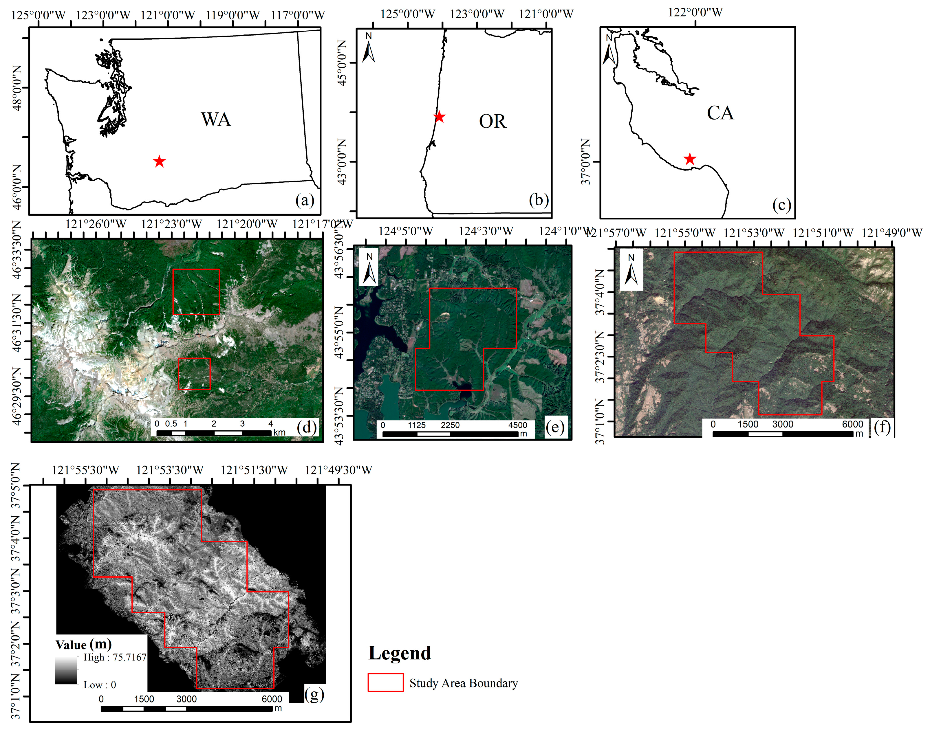
2.1. Study Sites
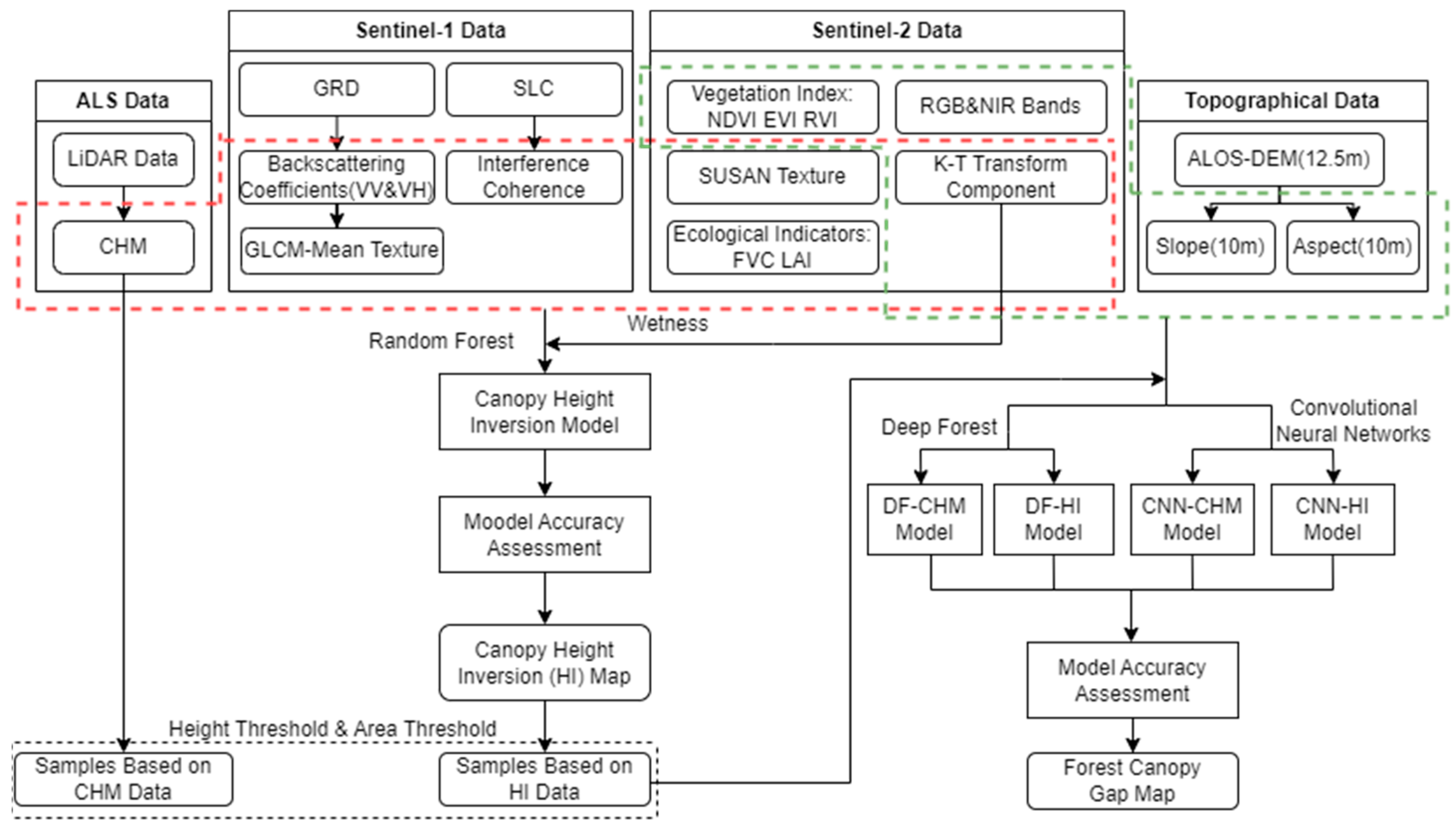
2.2. Data Acquisition and Pre-Processing
2.2.1. LiDAR Data
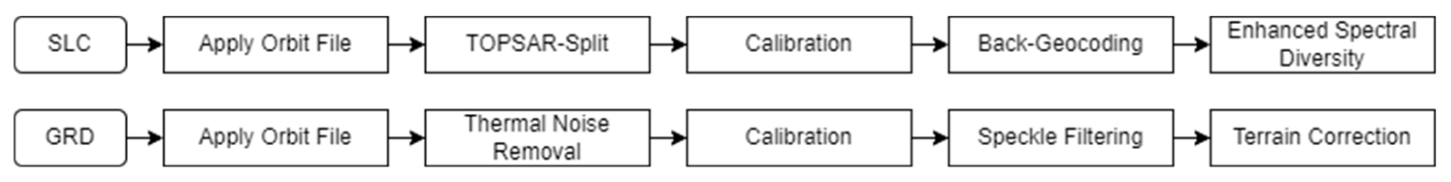
2.2.2. Sentinel Series Data
2.2.3. Google Earth Maps
2.2.4. ALOS DEM Data
2.3. Methods
2.3.1. Definition of Forest Gap
2.3.2. LiDAR-Based CHM Development
2.3.3. Feature Extraction Based on Sentinel and DEM Data
2.3.4. Canopy Height Inversion
2.3.5. Classification Sample Production
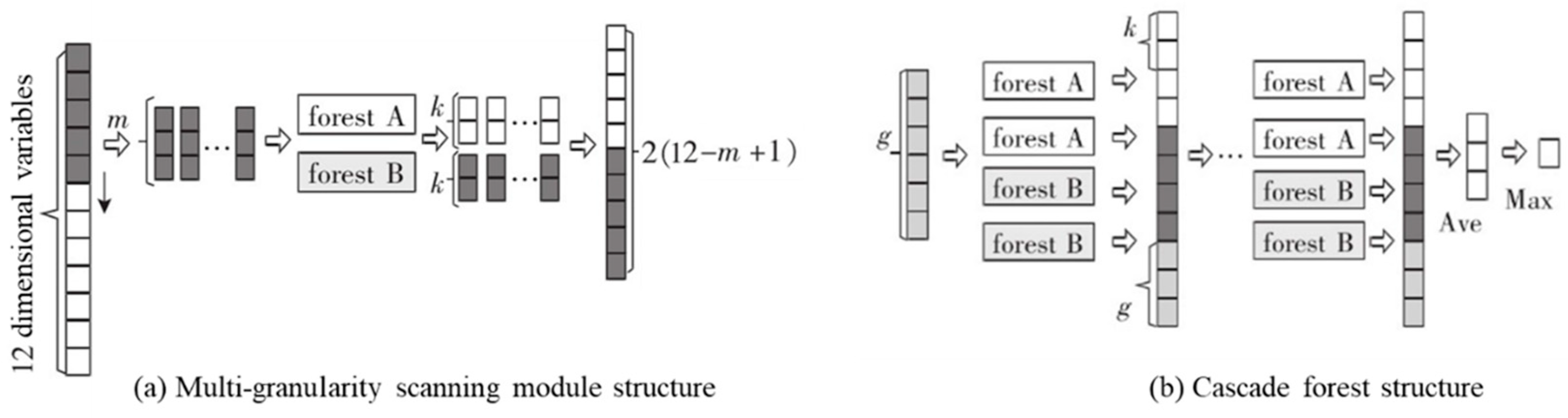
2.3.6. Forest Gap Extraction Modelling
2.4. Accuracy Verification
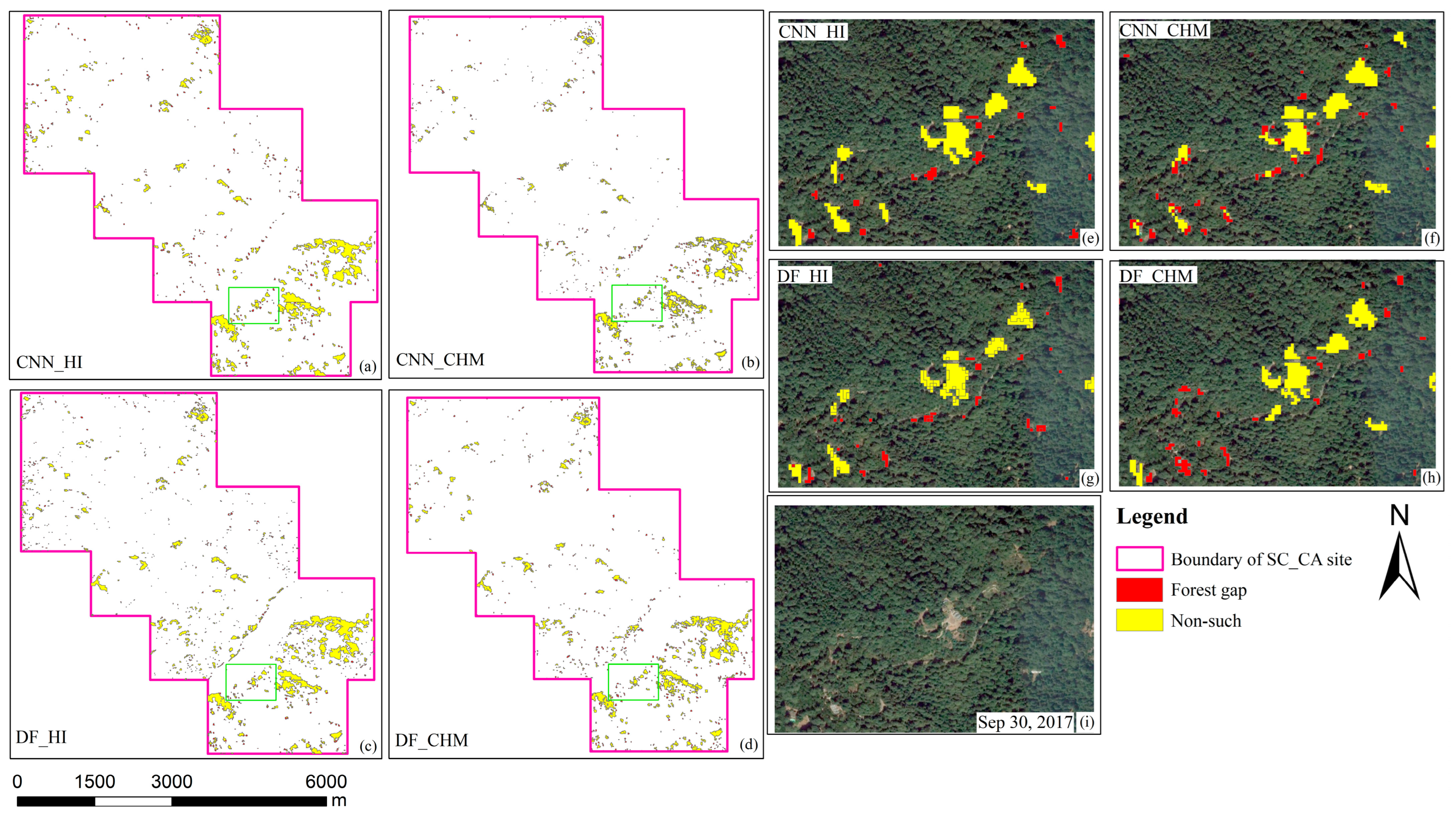
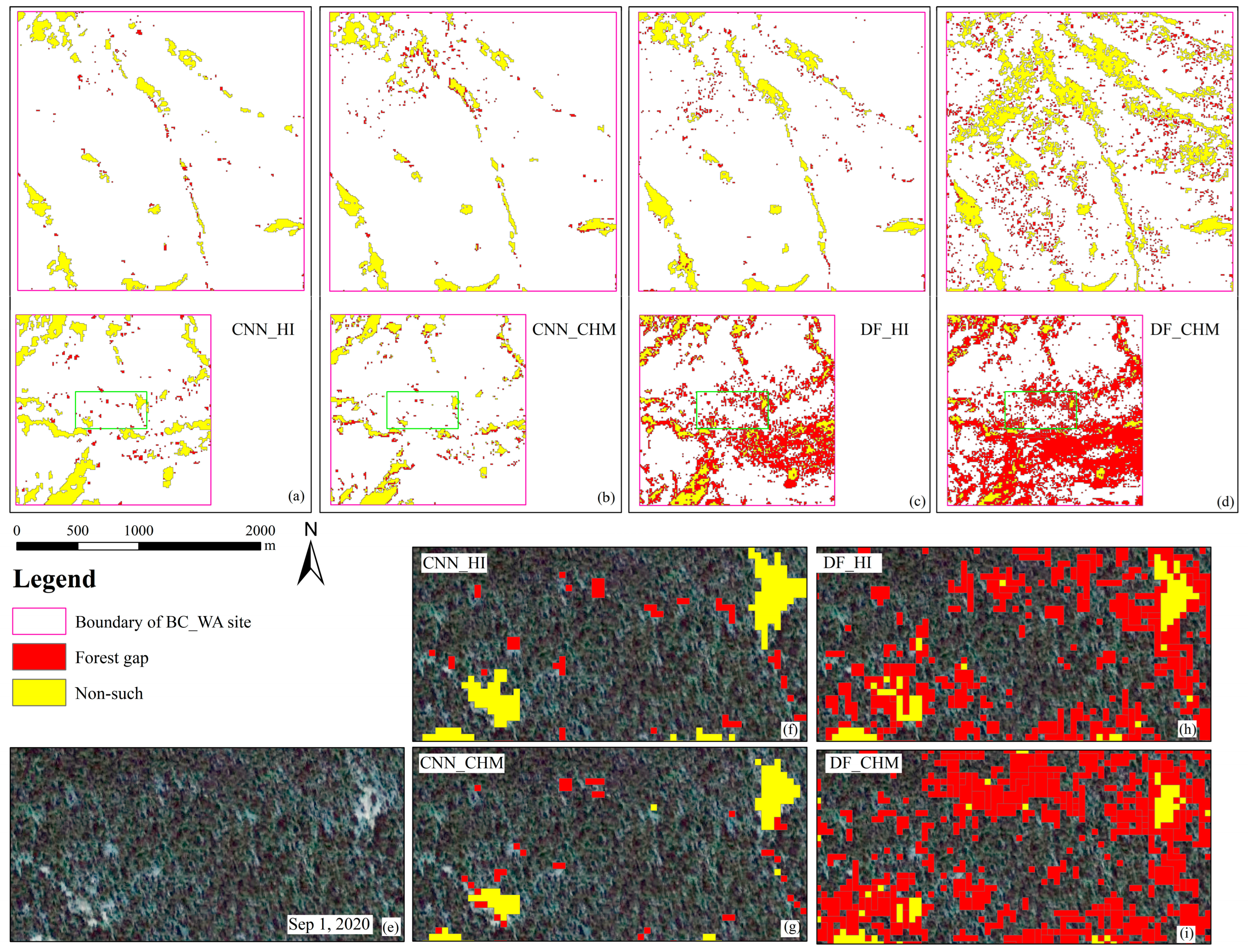
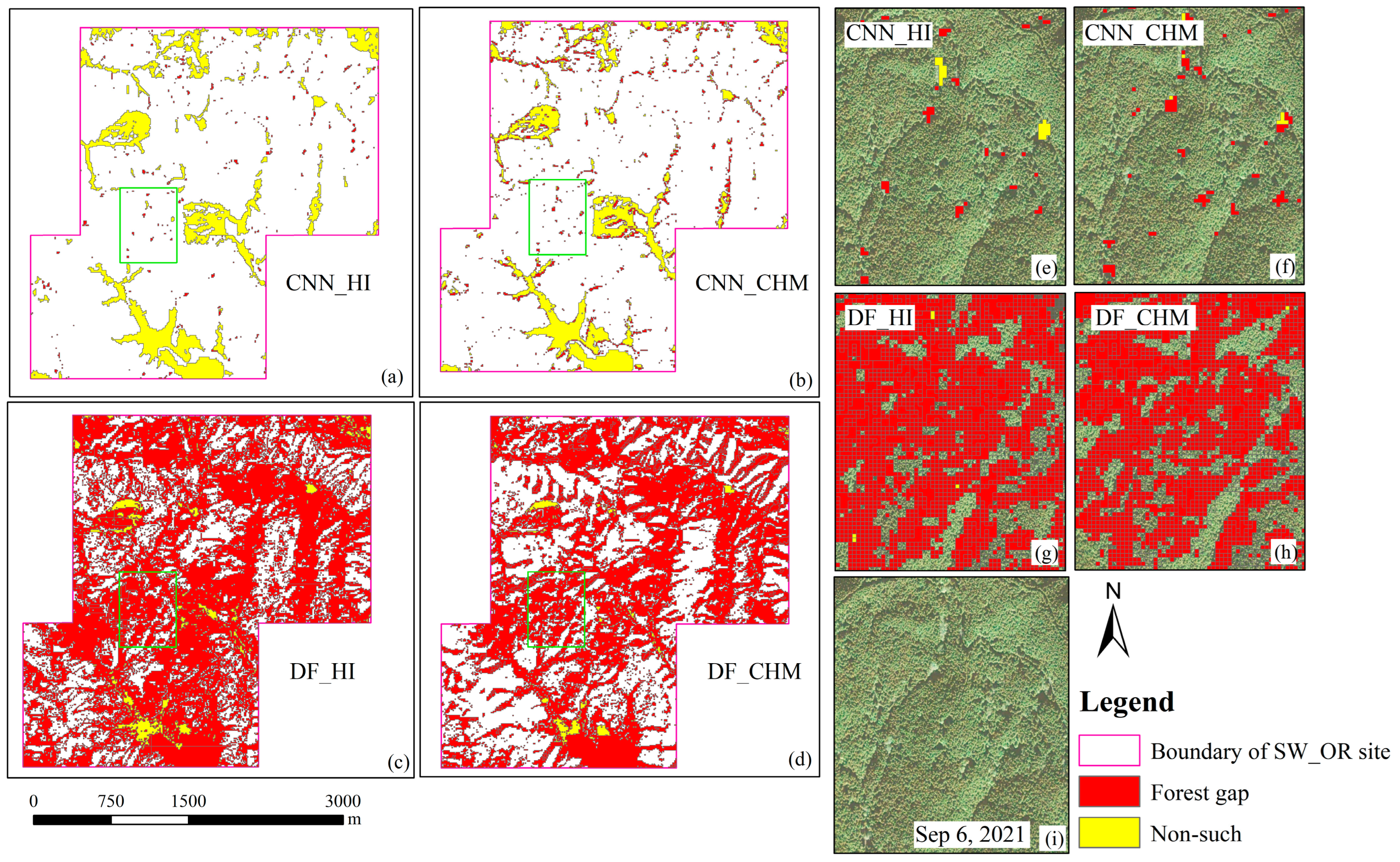
3. Results
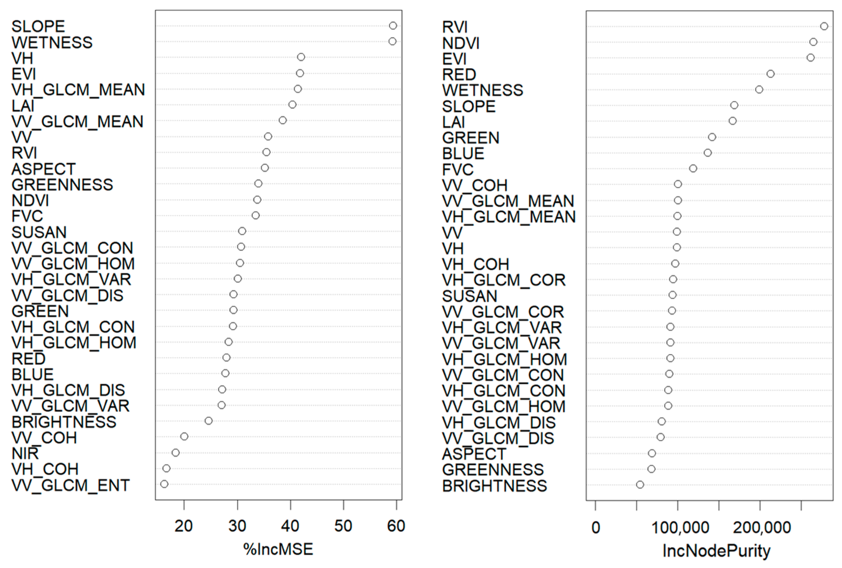
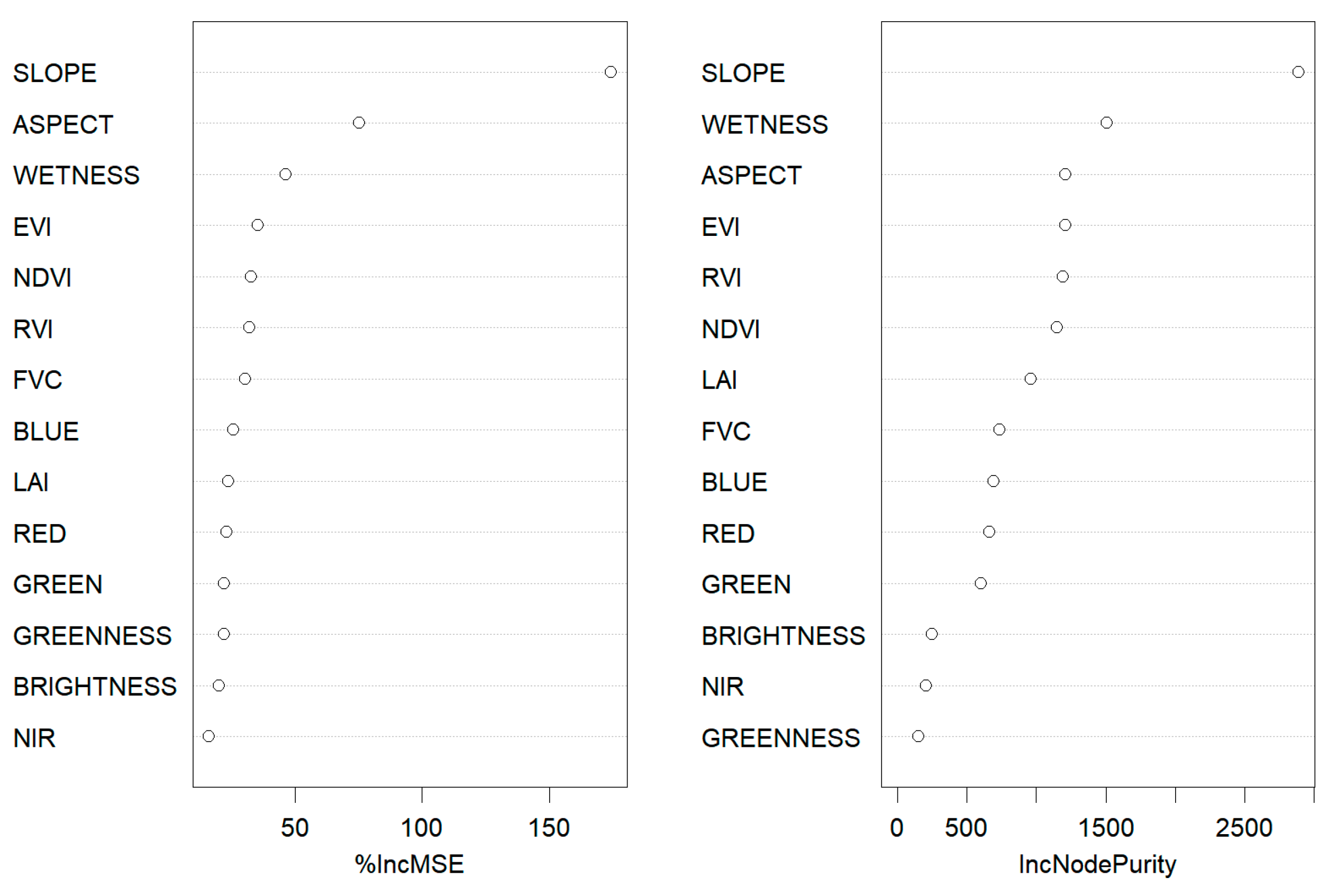
3.1. Feature Selection
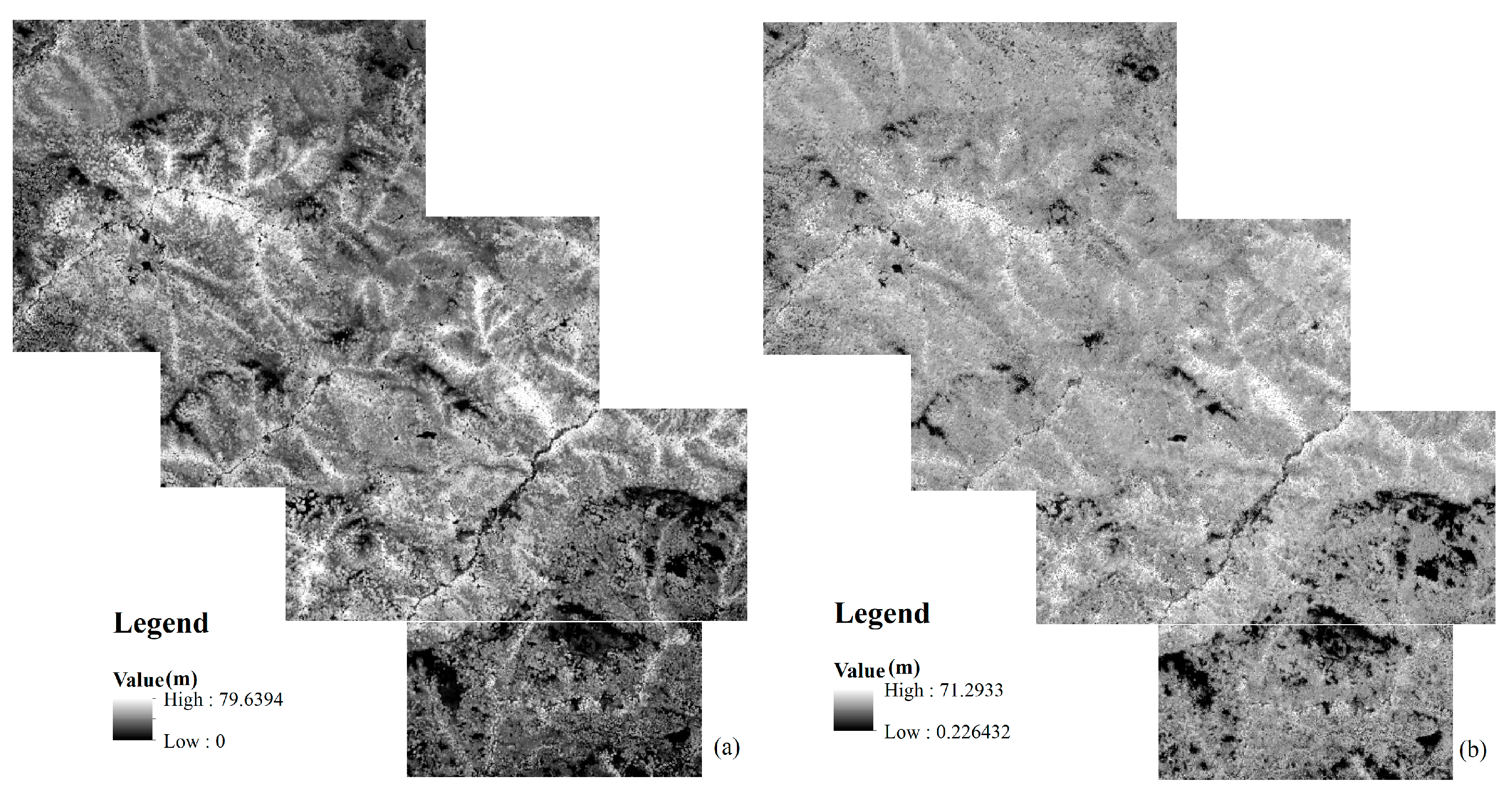
3.2. Canopy Height Inversion
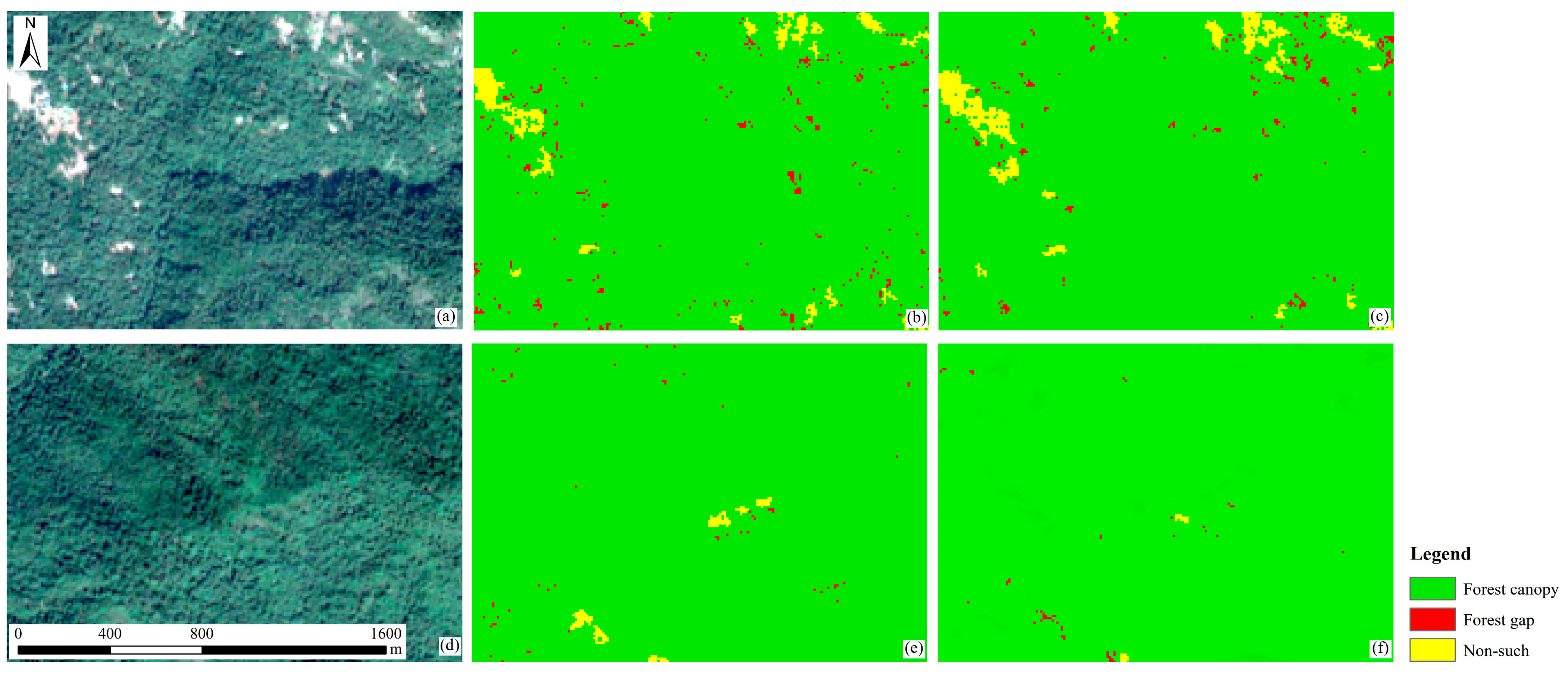
3.3. Forest Gap Samples
3.4. Accuracy of Forest Gap Extraction
4. Discussion
4.1. The Reliability of the HI Data and Its Influence on Subsequent Classification
4.2. Advantages and Potential of the Forest Gap Extraction Model
4.3. Inadequacies and Prospects
5. Conclusions
Author Contributions
Funding
Data Availability Statement
Conflicts of Interest
References
- Xia, B.; Deng, F.; He, S. Research Progress in Forest Gaps. J. Plant Resour. Environ. 1997, 6, 51–58. [Google Scholar]
- Hui, T.; Jiaojun, Z.; Hongzhang, K.; Liyue, H. A Research Review on Forest Gap Disturbance. Chin. J. Ecol. 2006, 26, 587–594. [Google Scholar]
- Getzin, S.; Nuske, R.; Wiegand, K. Using Unmanned Aerial Vehicles (UAV) to Quantify Spatial Gap Patterns in Forests. Remote Sens. 2014, 6, 6988–7004. [Google Scholar] [CrossRef]
- Orman, O.; Dobrowolska, D. Gap dynamics in the Western Carpathian mixed beech old-growth forests affected by spruce bark beetle outbreak. Eur. J. For. Res. 2017, 136, 571–581. [Google Scholar] [CrossRef]
- Muscolo, A.; Bagnato, S.; Sidari, M.; Mercurio, R. A review of the roles of forest canopy gaps. J. For. Res. 2014, 25, 725–736. [Google Scholar]
- Liu, B.; Zhao, P.; Zhou, M.; Wang, Y.; Yang, L.; Shu, Y. Effects of Forest Gaps on the Regeneration Pattern of the Undergrowth of Secondary Popular-Birch Forests in Southern Greater Xing’an Mountains. For. Resour. Manag. 2019, 31–36. [Google Scholar] [CrossRef]
- Runkle, J.R. Patterns of Disturbance in Some Old-Growth Mesic Forests of Eastern North America. Ecology 1982, 5, 1533–1546. [Google Scholar] [CrossRef]
- Zhu, J.J.; Zhang, G.Q.; Wang, G.G.; Yan, Q.L.; Lu, D.L.; Li, X.F.; Zheng, X. On the size of forest gaps: Can their lower and upper limits be objectively defined? Agr. For. Meteorol. 2015, 213, 64–76. [Google Scholar] [CrossRef]
- Watt, A.S. Pattern and process in the plant community. J. Ecol. 1947, 3, 1–22. [Google Scholar] [CrossRef]
- Runkle, J.R. Gap regeneration in some old-growth forests of the eastern United States. Ecology 1981, 4, 1041–1051. [Google Scholar] [CrossRef]
- Dietmaier, A.; McDermid, G.J.; Rahman, M.M.; Linke, J.; Ludwig, R. Comparison of LiDAR and Digital Aerial Photogrammetry for Characterizing Canopy Openings in the Boreal Forest of Northern Alberta. Remote Sens. 2019, 11, 1919. [Google Scholar] [CrossRef]
- Seidel, D.; Ammer, C.; Puettmann, K. Describing forest canopy gaps efficiently, accurately, and objectively: New prospects through the use of terrestrial laser scanning. Agric. For. Meteorol. 2015, 213, 23–32. [Google Scholar]
- Hu, L.; Zhu, J. Determination of the tridimensional shape of canopy gaps using two hemispherical photographs. Agric. For. Meteorol. 2009, 149, 862–872. [Google Scholar] [CrossRef]
- Liang, X.; Ye, W. Advances in Forest Gap Research (Review). J. Trop. Subtrop. Bot. 2001, 9, 355–364. [Google Scholar]
- Li, Y.; Zhang, G. Forest Gap Definition and Forest Gap Characteristics Measurement Methods. World For. Res. 2021, 34, 58–63. [Google Scholar]
- White, J.C.; Tompalski, P.; Coops, N.C.; Wulder, M.A. Comparison of airborne laser scanning and digital stereo imagery for characterizing forest canopy gaps in coastal temperate rainforests. Remote Sens. Environ. 2018, 208, 1–14. [Google Scholar]
- Du, Z.; Zheng, G.; Shen, G.; Moskal, L.M. Characterizing spatiotemporal variations of forest canopy gaps using aerial laser scanning data. Int. J. Appl. Earth Obs. 2021, 104, 102588. [Google Scholar] [CrossRef]
- Garbarino, M.; Mondino, E.B.; Lingua, E.; Nagel, T.A.; Dukic, V.; Govedar, Z.; Motta, R. Gap disturbances and regeneration patterns in a Bosnian old-growth forest: A multispectral remote sensing and ground-based approach. Ann. For. Sci. 2012, 69, 617–625. [Google Scholar] [CrossRef]
- Jayathunga, S.; Owari, T.; Tsuyuki, S. Evaluating the Performance of Photogrammetric Products Using Fixed-Wing UAV Imagery over a Mixed Conifer-Broadleaf Forest: Comparison with Airborne Laser Scanning. Remote Sens. 2018, 10, 187. [Google Scholar] [CrossRef]
- Vehmas, M.; Packalén, P.; Maltamo, M.; Eerikäinen, K. Using airborne laser scanning data for detecting canopy gaps and their understory type in mature boreal forest. Ann. For. Sci. 2011, 68, 825–835. [Google Scholar] [CrossRef]
- Sun, S.; Zhu, B.; Jing, L.; Chang, J.; Hu, L.; Song, L.; Chang, Q.; Sun, Y. Effects of Forest Gaps Disturbance on Regeneration Pattern of Pinus sylvestris var. mongolica Plantations. J. Northeast For. Univ. 2022, 50, 6–10. [Google Scholar]
- He, X.Y.; Ren, C.Y.; Chen, L.; Wang, Z.; Zheng, H. The Progress of Forest Ecosystems Monitoring with Remote Sensing Techniques. Sci. Geogr. Sin. 2018, 38, 997–1011. [Google Scholar]
- Bonnet, S.; Gaulton, R.; Lehaire, F.; Lejeune, P. Canopy Gap Mapping from Airborne Laser Scanning: An Assessment of the Positional and Geometrical Accuracy. Remote Sens. 2015, 7, 11267–11294. [Google Scholar] [CrossRef]
- Vepakomma, U.; St-Onge, B.; Kneeshaw, D. Spatially explicit characterization of boreal forest gap dynamics using multi-temporal lidar data. Remote Sens. Environ. 2008, 112, 2326–2340. [Google Scholar]
- Qi, Z.; Li, S.; Yue, W.; Liu, Q.; Li, Z. Forest gap identification in natural forest based on UAV LiDAR. J. Beijing For. Univ. 2022, 44, 44–53. [Google Scholar]
- Yun, Z.; Zheng, G.; Geng, Q.; Monika Moskal, L.; Wu, B.; Gong, P. Dynamic stratification for vertical forest structure using aerial laser scanning over multiple spatial scales. Int. J. Appl. Earth Obs. 2022, 114, 103040. [Google Scholar]
- Mao, X.; Hou, J.; Fan, W. Object-Based Automatic Recognition for Forest Gaps Using Aerial lmage and LiDAR Data. Sci. Silvae Sin. 2017, 53, 94–103. [Google Scholar]
- Schliemann, S.A.; Bockheim, J.G. Methods for studying treefall gaps: A review. For. Ecol. Manag. 2011, 7, 1143–1151. [Google Scholar]
- Lawton, R.O.; Putz, F.E. Natural disturbance and gap-phase regeneration in a wind-exposed tropical cloud forest. Ecology 1988, 3, 764–777. [Google Scholar] [CrossRef]
- Lorimer, C.G. Relative effects of small and large disturbances on temperate hardwood forest structure. Ecology 1989, 3, 565–567. [Google Scholar] [CrossRef]
- Yamamoto, S.I. Gap characteristics and gap regeneration in primary evergreen broad-leaved forest of western Japan. J. Plant Res. 1992, 1, 29–45. [Google Scholar] [CrossRef]
- Barton, I.; Kiraly, G.; Czimber, K.; Hollaus, M.; Pfeifer, N. Treefall Gap Mapping Using Sentinel-2 Images. Forests 2017, 8, 426. [Google Scholar] [CrossRef]
- Zhu, C.Y.; Zhu, J.J.; Wang, G.G.; Zheng, X.; Lu, D.L.; Gao, T. Dynamics of gaps and large openings in a secondary forest of Northeast China over 50 years. Ann. For. Sci. 2019, 76, 72. [Google Scholar] [CrossRef]
- Yang, J.; Jones, T.; Caspersen, J.; He, Y. Object-Based Canopy Gap Segmentation and Classification: Quantifying the Pros and Cons of Integrating Optical and LiDAR Data. Remote Sens. 2015, 7, 15917–15932. [Google Scholar] [CrossRef]
- Xia, J.; Wang, Y.; Dong, P.; He, S.; Zhao, F.; Luan, G. Object-Oriented Canopy Gap Extraction from UAV Images Based on Edge Enhancement. Remote Sens. 2022, 14, 4762. [Google Scholar] [CrossRef]
- Cagliero, E.; Morresi, D.; Marchi, N.; Paradis, L.; Finsinger, W.; Garbarino, M.; Lingua, E. Geomatics and Geospatial Technologies. Commun. Comput. Inf. Sci. 2022, 1507, 15–27. [Google Scholar]
- Lin, X.; Xu, M.; Cao, C.; Dang, Y.; Bashir, B.; Xie, B.; Huang, Z. Estimates of Forest Canopy Height Using a Combination of ICESat-2/ATLAS Data and Stereo-Photogrammetry. Remote Sens. 2020, 12, 3649. [Google Scholar] [CrossRef]
- Ghosh, S.M.; Behera, M.D.; Paramanik, S. Canopy Height Estimation Using Sentinel Series Images through Machine Learning Models in a Mangrove Forest. Remote Sens. 2020, 12, 1519. [Google Scholar] [CrossRef]
- Haotian, D. Research on Forest Parameter Inversion Method in Northeastern China Based on Optical and SAR Multi-Source Remote Sensing Data. Master’s Thesis, Jiling University, Changchun, China, 2022. [Google Scholar]
- Luo, Y.; Qi, S.; Liao, K.; Zhang, S.; Hu, B.; Tian, Y. Mapping the Forest Height by Fusion of ICESat-2 and Multi-Source Remote Sensing Imagery and Topographic Information: A Case Study in Jiangxi Province, China. Forests 2023, 14, 454. [Google Scholar] [CrossRef]
- Xi, Z.; Xu, H.; Xing, Y.; Gong, W.; Chen, G.; Yang, S. Forest Canopy Height Mapping by Synergizing ICESat-2, Sentinel-1, Sentinel-2 and Topographic Information Based on Machine Learning Methods. Remote Sens. 2022, 14, 364. [Google Scholar] [CrossRef]
- Cougo, M.; Souza-Filho, P.; Silva, A.; Fernandes, M.; Santos, J.; Abreu, M.; Nascimento, W.; Simard, M. Radarsat-2 Backscattering for the Modeling of Biophysical Parameters of Regenerating Mangrove Forests. Remote Sens. 2015, 7, 17097–17112. [Google Scholar] [CrossRef]
- Liu, Y.; Gong, W.; Xing, Y.; Hu, X.; Gong, J. Estimation of the forest stand mean height and aboveground biomass in Northeast China using SAR Sentinel-1B, multispectral Sentinel-2A, and DEM imagery. ISPRS J. Photogramm. 2019, 151, 277–289. [Google Scholar]
- Fu, W.X.; Guo, H.D.; Xie, C.; Lu, Y.C.; Li, X.W. Forest Height Inversion Using Dual-pol Polarimetric SAR Interferometry. IOP Conf. Ser. Earth Environ. Sci. 2014, 17, 12072. [Google Scholar] [CrossRef]
- Nedkov, R. Orthogonal Transformation of Segmented Images from the Satellite Sentinel-2. C. R.s L’académie Bulg. Sci. Sci. Math. Nat. 2017, 70, 687–692. [Google Scholar]
- He, T.; Wang, S. Multi-spectral remote sensing land-cover classification based on deep learning methods. J. Supercomput. 2021, 77, 2829–2843. [Google Scholar] [CrossRef]
- Li, Q.; Tian, J.; Tian, Q. Deep Learning Application for Crop Classification via Multi-Temporal Remote Sensing Images. Agriculture 2023, 13, 906. [Google Scholar]
- Lakshmi, T.R.V.; Reddy, C.V.K.; Kora, P.; Swaraja, K.; Meenakshi, K.; Kumari, C.U.; Reddy, L.P. Classification of multi-spectral data with fine-tuning variants of representative models. Multimed. Tools Appl. 2023. [Google Scholar] [CrossRef]
- Kotaridis, I.; Lazaridou, M. Cnns in land cover mapping with remote sensing imagery: A review and meta-analysis. Int. J. Remote Sens. 2023, 44, 5896–5935. [Google Scholar]
- Kattenborn, T.; Leitloff, J.; Schiefer, F.; Hinz, S. Review on Convolutional Neural Networks (CNN) in vegetation remote sensing. ISPRS J. Photogramm. 2021, 173, 24–49. [Google Scholar]
- Boston, T.; Van Dijk, A.; Thackway, R. Convolutional Neural Network Shows Greater Spatial and Temporal Stability in Multi-Annual Land Cover Mapping Than Pixel-Based Methods. Remote Sens. 2023, 15, 2132. [Google Scholar]
- Lassalle, G.; Souza Filho, C.R.; Disney, M.; Friess, D. Tracking canopy gaps in mangroves remotely using deep learning. Remote Sens. Ecol. Con. 2022, 8, 890–903. [Google Scholar] [CrossRef]
- Duvall, A. High Resolution Topography near Santa Cruz; OpenTopography: San Diego, CA, USA, 2017. [Google Scholar]
- Yamamoto, S.I. The gap theory in forest dynamics. Bot. Mag. 1992, 105, 375–383. [Google Scholar] [CrossRef]
- Zang, R.; Xu, H. Advances in Forest Gap Disturbance Research. Sci. Silvae Sin. 1998, 34, 90–98. [Google Scholar]
- Tyrrell, L.E.; Crow, T.R. Structural characteristics of old-growth hemlock-hardwood forests in relation to age. Ecology 1994, 2, 370–386. [Google Scholar] [CrossRef]
- Liu, H.C.; He, G.J. Shape feature extraction of high resolution remote sensing image based on SUSAN and moment invariant. In Proceedings of the 2008 Congress on Image and Signal Processing, Sanya, China, 27–30 May 2008; Li, D., Deng, G., Eds.; IEEE: New York, NY, USA, 2008; Volume 2, pp. 801–807. [Google Scholar]
- Liangyuan, H.; Fulong, L.; Xiaojie, L.; Wenda, Z.; Yachao, S. Prediction model of sintered ore drum index based on deep forest algorithm. Metall. Ind. Autom. 2022, 46, 78–85. [Google Scholar]
- Zhou, Z.; Feng, J. Deep Forest. Natl. Sci. Rev. 2019, 6, 74–86. [Google Scholar]
- Lecun, Y.; Member, I.; Bottou, L.; Bengio, Y.; Haffner, P. Gradient-Based Learning Applied to Document Recognition. Proc. IEEE 1998, 11, 2278–2324. [Google Scholar] [CrossRef]
- Szegedy, C.; Liu, W.; Jia, Y.; Sermanet, P.; Reed, S.; Anguelov, D.; Erhan, D.; Vanhoucke, V.; Rabinovich, A. Going Deeper with Convolutions. In Proceedings of the IEEE Conference on Computer Vision and Pattern Recognition (CVPR), Boston, MA, USA, 7–12 June 2015. [Google Scholar]
- Krizhevsky, A.; Sutskever, I.; Hinton, G.E. ImageNet classification with deep convolutional neural networks. Commun. Acm 2017, 60, 84–90. [Google Scholar] [CrossRef]
- Simonyan, K.; Zisserman, A. Very Deep Convolutional Networks for Large-scale Image Recognition. In Proceedings of the 3rd International Conference on Learning Representations, San Diego, CA, USA, 7–9 May 2015. [Google Scholar]
- LeCun, Y.; Bengio, Y.; Hinton, G. Deep learning. Nature 2015, 7553, 436–444. [Google Scholar] [CrossRef]
- Zhou, F.; Jin, L.; Dong, J. Review of Convolutional Neural Network. Chin. J. Comput. 2017, 06, 1229–1251. [Google Scholar]
- Jin, H. An Analytical Study based on Pixel-based and Object-oriented Classification Methods. Jiangsu Sci. Technol. Inf. 2014, 31, 38–40. [Google Scholar]
- Hobi, M.L.; Ginzler, C.; Commarmot, B.; Bugmann, H. Gap pattern of the largest primeval beech forest of Europe revealed by remote sensing. Ecosphere 2015, 6, 1–15. [Google Scholar] [CrossRef]
- Healey, S.P.; Cohen, W.B.; Yang, Z.Q.; Krankina, O.N. Comparison of Tasseled Cap-based Landsat data structures for use in forest disturbance detection. Remote Sens. Environ. 2005, 97, 301–310. [Google Scholar] [CrossRef]
- Guild, L.S.; Cohen, W.B.; Kauffman, J.B. Detection of deforestation and land conversion in Rondônia, Brazil using change detection techniques. Int. J. Remote Sens. 2010, 25, 731–750. [Google Scholar] [CrossRef]
- Min, X. Advances in Study on Vegetation Indeices. Adv. Earth Sci. 1998, 13, 10–16. [Google Scholar]
- Gaulton, R.; Malthus, T.J. LiDAR mapping of canopy gaps in continuous cover forests: A comparison of canopy height model and point cloud based techniques. Int. J. Remote Sens. 2010, 31, 1193–1211. [Google Scholar] [CrossRef]
- Zhang, X.S.; Zhuang, Y.; Yan, F.; Wang, W. Status and Development of Transfer Learning Based Category-Level Object Recognition and Detection. Acta Autom. Sin. 2019, 45, 1224–1243. [Google Scholar]
- Srivastava, N.; Hinton, G.; Krizhevsky, A.; Sutskever, I.; Salakhutdinov, R. Dropout: A Simple Way to Prevent Neural Networks from Overfitting. J. Mach. Learn Res. 2014, 15, 1929–1958. [Google Scholar]
- Utkin, L.V.; Ryabinin, M.A. A Deep Forest for Transductive Transfer Learning by Using a Consensus Measure. In Proceedings of the Conference on Artificial Intelligence and Natural Language, St. Petersburg, Russia, 20–23 September 2017. [Google Scholar]
- Jagannathan, J.; Divya, C. Deep learning for the prediction and classification of land use and land cover changes using deep convolutional neural network. Ecol. Inf. 2021, 65, 101412. [Google Scholar] [CrossRef]
- Lang, N.; Schindler, K.; Wegner, J.D. Country-wide high-resolution vegetation height mapping with Sentinel-2. Remote Sens. Environ. 2019, 233, 111347. [Google Scholar] [CrossRef]
- Zhu, Y.; Li, Q.; Lv, Z.; Falco, N. Novel Land Cover Change Detection Deep Learning Framework with Very Small Initial Samples Using Heterogeneous Remote Sensing Images. Remote Sens. 2023, 15, 4609. [Google Scholar] [CrossRef]
- Kenderes, K.; Mihok, B.; Standovar, T. Thirty years of gap dynamics in a central european beech forest reserve. Forestry 2008, 81, 111–123. [Google Scholar] [CrossRef]
- Dobrowolska, D.; Piasecka, Ż.; Kuberski, A.; Stereńczak, K. Canopy gap characteristics and regeneration patterns in the Białowieża forest based on remote sensing data and field measurements. For. Ecol. Manag. 2022, 511, 120123. [Google Scholar] [CrossRef]
- Himes, J.M.; Rentch, J.S. Canopy Gap Dynamics in a Second-Growth Appalachian Hardwood Forest in West Virginia. Castanea 2013, 78, 171–184. [Google Scholar] [CrossRef] [PubMed]


| Acquisition Date | Mission Identifier | Product Type | Polarization | Orbit Number | Product Unique ID |
|---|---|---|---|---|---|
| 4 October 2017 | S1A | SLC | VV + VH | 018664 | 0503 |
| 16 October 2017 | S1A | SLC | VV + VH | 018839 | 21A5 |
| 10 October 2017 | S1B | GRD | VV + VH | 007761 | 7170 |
| Acquisition Date | Mission Identifier | Product Level | Baseline& Orbit Number | Training/Validation Set &Corresponding Site |
|---|---|---|---|---|
| 30 August 2020 | S2A | L2A | N0214_R013 | Validation Set (BC_WA) |
| 4 September 2021 | S2A | L2A | N0301_R056 | Validation Set (SW_OR) |
| 12 October 2017 | S2B | L2A | N0205_R113 | Training Set (SC_CA) |
| Acquisition Date | Spatial Resolution | Corresponding Site |
|---|---|---|
| 1 September 2020 | 1.5 m | BC_WA |
| 6 September 2021 | 1.0 m | SW_OR |
| 30 September 2017 | 1.5 m | SC_CA |
| Acquisition Date | Absolute Orbit Number | Corresponding Site |
|---|---|---|
| 27 April 2010 | 22,671 | BC_WA |
| 28 November 2008 | 15,166 | SW_OR |
| 28 August 2007 | 8478 | SC_CA |
| CHM | HI | |
|---|---|---|
| Min. (m) | 0.00 | 0.23 |
| Max. (m) | 76.62 | 71.29 |
| Mean (m) | 32.66 | 32.69 |
| Standard deviation (m) | 12.95 | 8.25 |
| Class | CHM-Identified Pixels | HI-Identified Pixels | Spatially Collocated Pixels |
|---|---|---|---|
| Forest canopy | 281,056 | 283,741 | 280,370 |
| Forest gap | 2370 | 1503 | 1301 |
| Non-such | 5999 | 4181 | 3697 |
| CNN_HI | CNN_CHM | DF_HI | DF_CHM | |
|---|---|---|---|---|
| OA | 0.85 | 0.81 | 0.80 | 0.91 |
| Kappa coefficient | 0.78 | 0.71 | 0.69 | 0.86 |
| UA | 0.71 | 0.58 | 0.55 | 0.84 |
| PA | 0.89 | 0.86 | 0.94 | 0.94 |
| DF-CHM | DF-HI | |||
|---|---|---|---|---|
| SW_OR | BC_WA | SW_OR | BC_WA | |
| OA | 0.55 | 0.62 | 0.42 | 0.79 |
| Kappa coefficient | 0.14 | 0.41 | 0.16 | 0.61 |
| UA | 0.11 | 0.24 | 0.06 | 0.56 |
| PA | 0.32 | 0.48 | 0.26 | 0.76 |
| CNN-CHM | CNN-HI | |||
| SW_OR | BC_WA | SW_OR | BC_WA | |
| OA | 0.73 | 0.69 | 0.85 | 0.87 |
| Kappa coefficient | 0.59 | 0.54 | 0.78 | 0.81 |
| UA | 0.56 | 0.58 | 0.82 | 0.84 |
| PA | 0.65 | 0.66 | 0.74 | 0.78 |
Disclaimer/Publisher’s Note: The statements, opinions and data contained in all publications are solely those of the individual author(s) and contributor(s) and not of MDPI and/or the editor(s). MDPI and/or the editor(s) disclaim responsibility for any injury to people or property resulting from any ideas, methods, instructions or products referred to in the content. |
© 2023 by the authors. Licensee MDPI, Basel, Switzerland. This article is an open access article distributed under the terms and conditions of the Creative Commons Attribution (CC BY) license (https://creativecommons.org/licenses/by/4.0/).
Share and Cite
Li, M.; Li, M. Forest Gap Extraction Based on Convolutional Neural Networks and Sentinel-2 Images. Forests 2023, 14, 2146. https://doi.org/10.3390/f14112146
Li M, Li M. Forest Gap Extraction Based on Convolutional Neural Networks and Sentinel-2 Images. Forests. 2023; 14(11):2146. https://doi.org/10.3390/f14112146
Chicago/Turabian StyleLi, Muxuan, and Mingshi Li. 2023. "Forest Gap Extraction Based on Convolutional Neural Networks and Sentinel-2 Images" Forests 14, no. 11: 2146. https://doi.org/10.3390/f14112146
APA StyleLi, M., & Li, M. (2023). Forest Gap Extraction Based on Convolutional Neural Networks and Sentinel-2 Images. Forests, 14(11), 2146. https://doi.org/10.3390/f14112146