Article

Assessing the Effects of Conservation Measures on Soil Erosion in Arasbaran Forests Using RUSLE

by
Samira Sasanifar
1,
Ahmad Alijanpour
1,*,
Abbas Banj Shafiei
1,
Javad Eshaghi Rad
1,
Morteza Molaei
2 and
Pedro Álvarez-Álvarez
3
1
Department of forestry, Faculty of Natural Resources, Urmia University, Urmia 5756151818, Iran
2
Department of agricultural economics, Faculty of Agriculture, Urmia University, Urmia 5756151818, Iran
3
Department of Organisms and Systems Biology, Polytechnic School of Mieres, University of Oviedo, E-33600 Mieres, Asturias, Spain
*
Author to whom correspondence should be addressed.
Forests 2023, 14(10), 1942; https://doi.org/10.3390/f14101942
Submission received: 31 July 2023 / Revised: 13 September 2023 / Accepted: 21 September 2023 / Published: 24 September 2023
(This article belongs to the Section Forest Soil)

Abstract

:
Vegetation cover is known as one of the most dominant parameters in soil erosion that can considerably affect soil erosion drivers. This study aimed to assess the effects of vegetation cover on soil conservation in Arasbaran Forests, Iran. A part of Arsbaran forests has been protected for 45 years. The other part has not been under protection during these years. This study was carried out in order to investigate the effects of forest protection management on the changes in the amount of soil erosion and compare it with the non-protection sector. To this end, 66 samples were grouped in the two selected elevation classes. Out of every three sample plots, one plot was randomly selected for collecting soil samples. Landsat 8 images and a Digital Elevation Model were utilized for sample collection via ENVI (Environment for Visualizing Images) and GIS (Geographic Information System), respectively. Then, the Revised Universal Soil Loss Equation (RUSLE) was employed to estimate the annual soil loss in the studied sites. The results showed the annual soil erosion of 9.84 and 10.06 tons per hectare/year for protected and non-protected areas, respectively. Moreover, the average annual soil erosion of 9.95 tons per hectare/year was calculated for the whole Arasbaran Forests. The results of the statistical test revealed no significant difference between protected and non-protected sites in terms of erosion rates (p > 0.05). Based on the findings, despite the non-significant and slightly lower soil loss per unit area in the protected site, there is a notable soil loss throughout the entire non-protected area. It appears necessary to conduct a thorough review of existing conservation laws and to closely monitor their effective implementation. This step is crucial for enhancing the effectiveness of forest conservation management in mitigating soil erosion. The results show that absolute forest protection alone cannot make a big difference in preventing soil erosion. In this regard, there is a need to carry silviculture measures to manage protected forest stands to increase the sustainability of the forest. Obviously, in the case of proper management along with protection, it is possible to have a greater effect in preventing soil erosion.

1. Introduction

Soil is one of the prominent components of forest ecosystems that is subjected to degradation by natural and anthropogenic processes [1,2,3]. The quality of the forest soil, in particular, plays a vital role in supporting various ecosystem functions, including land conservation and carbon sequestration [4,5].
Soil properties are spatially and temporally various due to different conditions of soil-forming factors and management measures in forest regions.
The vegetation and species composition are also expected to affect the physical and chemical properties of the soil due to changes in biomass, including material residues, as well as aboveground and underground biomass [6]. Moreover, changes in the vegetation cover caused by different management approaches may result in long-term changes in soil characteristics to such an extent that the soil does not return to its original conditions [7]. Therefore, inappropriate management activities associated with land-use change can aggravate the negative effects on soil properties [8,9].
Soil erosion at medium and high altitudes of forest regions is higher than at low altitudes. Further, soil erosion can cause negative effects on the soil, including irreversible losses of fertile land [10,11], frequently leading to severe consequences in terms of socio-economic and environmental sectors [12]. Inappropriate soil management, along with extensive land-use changes, can expose the soil to erosion, finally having various on- and off-site consequences [13,14]. Various models have been developed to address challenges related to soil erosion. The RUSLE has been a widely used model concerning soil erosion studies due to the availability of its information, suitability for extensive land use (watershed, rangeland, and forest), and high accuracy.
Numerous studies have utilized the RUSLE/USLE (Universal Soil Loss Equation) model to evaluate soil loss while considering vegetation cover as a management strategy. For instance, researchers reviewing the studies conducted in relation to the RUSLE stated that any alteration in the C factor (in the RUSLE model) can have a substantial impact on the results [15]. Likewise, the RS- and GIS-associated RUSLE was applied to evaluate the rate of soil loss and sediment in the Shatt Al-Arab basin (Iraq-Iran), and their results suggested the high soil loss rates are associated with heavy rainfall, loamy soil predominance, elevated terrains/plateau borders with a steep side slope and intensive farming. Managers and policymakers may use the results of the study to implement adequate conservation programs to prevent soil erosion [16]. Other researchers estimated soil erosion using RUSLE and found that the average annual soil loss in Iran is approximately 24 tons per hectare/year [17]. Their results for the East Azerbaijan province indicated varied rates of erosion from 35 to 40 tons per hectare/year. They also concluded that the vegetation cover plays a key role in reducing soil erosion.
Other researchers employed the RUSLE model to investigate runoff generation in China. Their findings indicated that the soil erosion volume had increased due to a decline in forested areas and decreased with the growth of trees [18]. By investigating the effects of land use change on soil erosion using RUSLE in the tropical regions of India, the researchers concluded that forest areas play an important role in determining the amount of erosion, and where there is dense forest, the amount of erosion is lower [19]. Some researcher evaluated soil erosion using RUSLE in Bosnia and Herzegovina and concluded that deforestation has led to an increase in soil erosion. These researchers stated that the combination of RUSLE and GIS as tools provides us with a quick and accurate way to find possible solutions to problems resulting from intensive use and inadequate monitoring [20]. The effects of the land cover change on the surface runoff and sediment in northern China were studied, and the results revealed that the rate of sediment, runoff, and soil erosion in the forest was less than that of the other land-use types [21]. Researchers demonstrated that severe and slight soil erosions occur on steeper slopes and dense vegetation, respectively [22].
In total, the soil erosion in Iran is three-fold and twenty-fold greater compared to Asian countries and the world average annually, respectively, imposing high costs, approximately USD 56–112 billion per year, on Iran [23]. Due to the situation of soil erosion in Iran, collecting data regarding soil erosion is a necessary action that can significantly decrease the time and costs [17].
Considering that forest protection affects all quantitative and qualitative indicators, such as the forest soil, this study mainly aimed to evaluate the soil erosion in protected and non-protected areas using RUSLE and then assess the effects of protection measures on soil preservation. Additionally, as the sub-objectives in this research, two elevation classes were considered for investigating the effect of conservation management on soil erosion in different elevation classes.
This study is of great significance as it evaluates the effectiveness of conservation measures in mitigating soil erosion in Arasbaran Forests, a region that is ecologically important due to its biodiversity and ecosystem services. The findings of the study can provide valuable insights for future conservation efforts and the development of sustainable land management practices.

2. Materials and Methods

2.1. Study Area

Arasbaran Forests are located in the East Azerbaijan province, the northwestern part of Iran (Figure 1). Nearly 56% of these forests (more than 72,400 hectares) have been designated as protected areas since 1971. In the protected area, exploitation, coal mining, and hunting, as the activities that probably cause damage to the forest, have been banned [24]. According to statistics related to 1999–2017 from the Kaleybar meteorology station, the annual rainfall ranges from 298.4 to 561.8 mm, and its average annual rainfall is approximately 404.18 mm. However, the region benefits from a large number of foggy days, and relative humidity reaches 85% in June, which plays an important role in supporting the water balance of the region. The annual average temperature varies across the region; the low and high temperatures are approximately 5 and 17 °C, respectively. According to the De Marton classification, Arasbaran Forests have a Mediterranean climate [25]. The limestone and igneous are the two dominant lithology units that geologically belong to the third period [25,26].
The soils of Arasbaran Forests are shallow to moderately deep, and the rock outcrop can be seen in some cases. In addition to their flora, these forests include many plant species of the Hyrcanian, the western parts of Iran, and the Caucasus regions. Due to such rich genetic diversity, they have received the special attention of botanists worldwide [26,27].
Nowadays, conservation management is generally accepted, and the government has subsequently ratified restrictions against destructive activities across the region; this action has led to the protection of vegetation [24].

2.2. Data

This study was carried out in the Arasbaran Forests area, where both protected and non-protected areas were located adjacent to each other and served as study sites. The comparison of these sites in terms of their contributions to soil conservation was based on the extent of the forest coverage and in consideration of prior studies [25], the protected and non-protected areas were divided into two elevation classes, including 1000–1500 and 1500–2000 m above sea level (masl) [26]. Then, the forest stands were selected to study at those classified elevations on the northern slopes.
The census network of 150 m × 300 m was designed for the whole area, and then 22 sample plots (with an area of 3R) were assigned to each of the protected and non-protected areas (In this way, in each area, 11 sample plots were established at an altitude belt of 1000 to 1500 and 11 sample plots were established at an altitude of 1500 to 200 m). Soil structure and permeability class of soil profile were measured at sample plots. In the end, a composite soil sample was collected from each sample plot at a depth of 0–30 cm. After transporting the soil sample to the laboratory, we measured the parameters of silt, very fine sand, and organic matter percentage, which were subsequently used to calculate the K index [25,28].

2.3. RUSLE

The RUSLE captures soil erosion using six erosion driving factors and is expressed by Equation (1) as follows [29]:
A = R × K × L × S × C × P
where A, R, K, L, S, C, and P represent the average annual soil erosion per unit area, rainfall erosivity, soil erodibility, slope length, slope steepness, cover and management, and conservation supporting practice factor, respectively. The calculation processes for the mentioned factors are individually described below.

2.3.1. Rainfall Erosivity Factor (R)

Rainfall erosivity is defined as the compressive strength of rain in the erosion process [6,29,30,31]. The Fournier index is one of the most appropriate and widely used methods in calculating the R factor, whose relationship has been confirmed by previous studies [32,33]. The Fournier index (F) relation is represented by Equation (2) as follows [31]:
F = p i 2 p
where pi and p are the monthly mean rainfall (mm) in month i and the annual mean rainfall (mm), respectively. In this study, monthly precipitation data from the Kaleybar station (the closest meteorological station to the study area) during 2000–2017 were used to calculate the Fournier index and R factor by Equations (3) and (4) [31].
R = 0.07397 × F 1.847              I f   F > 55
R = 95.77 6.081 × F + 0.477 × F 2          I f   F 55

2.3.2. Soil Erodibility Factor (K)

Soil erodibility factor (K), which implies soil susceptibility to erosion, is often determined using soil properties [34,35,36]. In the present study, by obtaining the percentages of silt, very fine sand, the percentage of organic matter, soil structure code, and the permeability class of soil profile and placing the values in Equation (5), the K index values were calculated for each sample plot.
K = 2.73 × 10 6 m 1.14 12 a + 3.25 × 10 2 b 2 + 2.5 × 10 2 ( c 3 )
where m denotes the particle diameter ((percentage of silt + percentage of very fine sand) × (percentage of clay − 100)). In addition, a, b, and c represent the percentage of the organic matter, soil structure code, and soil permeability, respectively.

2.3.3. Topographic Factor (LS)

The factors L and S in the RUSLE indicate the effects of topography on soil erosion. The specific effects of topography on soil erosion are captured by the dimensionless LS factor [29,37,38]. The slope map of the region was prepared from the DEM (Digital Elevation Model) map (with a resolution of 10 m) of the region in ArcGIS environment [39]. The LS map was prepared by generating a flow accumulation map using the Spatial Analyst function and Hydrotools extension and the generated slope map (Equation (6)). The LS values of sample plots were extracted by geographical location.
( F l o w   A c c u m u l a t i o n × 30 22.13 0.4 × sin s l o p × 0.01745 0.0896 ) 1.3 × 1.4

2.3.4. Cover and Management Factor (C)

The Normalized Vegetation Difference Index (NDVI), Equation (7), which is calculated using remote sensing techniques, is the most widely used criterion for calculating factor C in RUSLE [40,41,42].
N D V I = I R R I R + R
In this study, the NDVI (normalized difference vegetation index) index was computed using Landsat images from July 2016 with frame number 168,033. Band number 4 was utilized as the red band (R), and band number 5 was used as the infrared band (NIR) in Equation (7). In the end, C indices for the entire region were computed by utilizing ENVI software and Equation (8). Subsequently, the C value for each sample plot was determined by referencing the image derived from the regional C index and the geographical coordinates of each plot’s center.
C = 1 N D V I 2

2.3.5. Conservation Supporting Practice Factor (P)

Factor P is a ratio of the eroded soil despite the conservation and support measures such as terraces or planting strips, and 1 is considered a P factor for areas without management operations [43].
All the presented factors were determined using SPSS, GIS, and ENVI in both studied regions. After computing all six factors for each sample plot, the soil loss (average soil erosion per ton/ha) was estimated for each sample plot, followed by calculating the average soil erosion for each study area individually. Next, an independent t-test and Mann–Whitney test were employed to compare the rate of soil erosion between the two studied sites based on the normality and non-normality of the data distribution. In addition, the two-way analysis of variance was applied to assess the interplead and distinct effects of management treatments (in protected and non-protected areas) and altitude (in the altitude classes of 1000–1500 and 1500–2000 MLS) on soil erosion. Figure 2 depicts different methodological steps of this study.
Table 1 presents the factors used in the RUSLE model to evaluate soil erosion in the Arasbaran region. The factors include rainfall erosivity factor (R), soil erodibility factor (K), and topographic factor (LS). Information is provided on the source and required data for each factor, such as the nearest meteorological station for the R factor, soil samples for the K factor, and a slope map for the LS factor.

3. Results

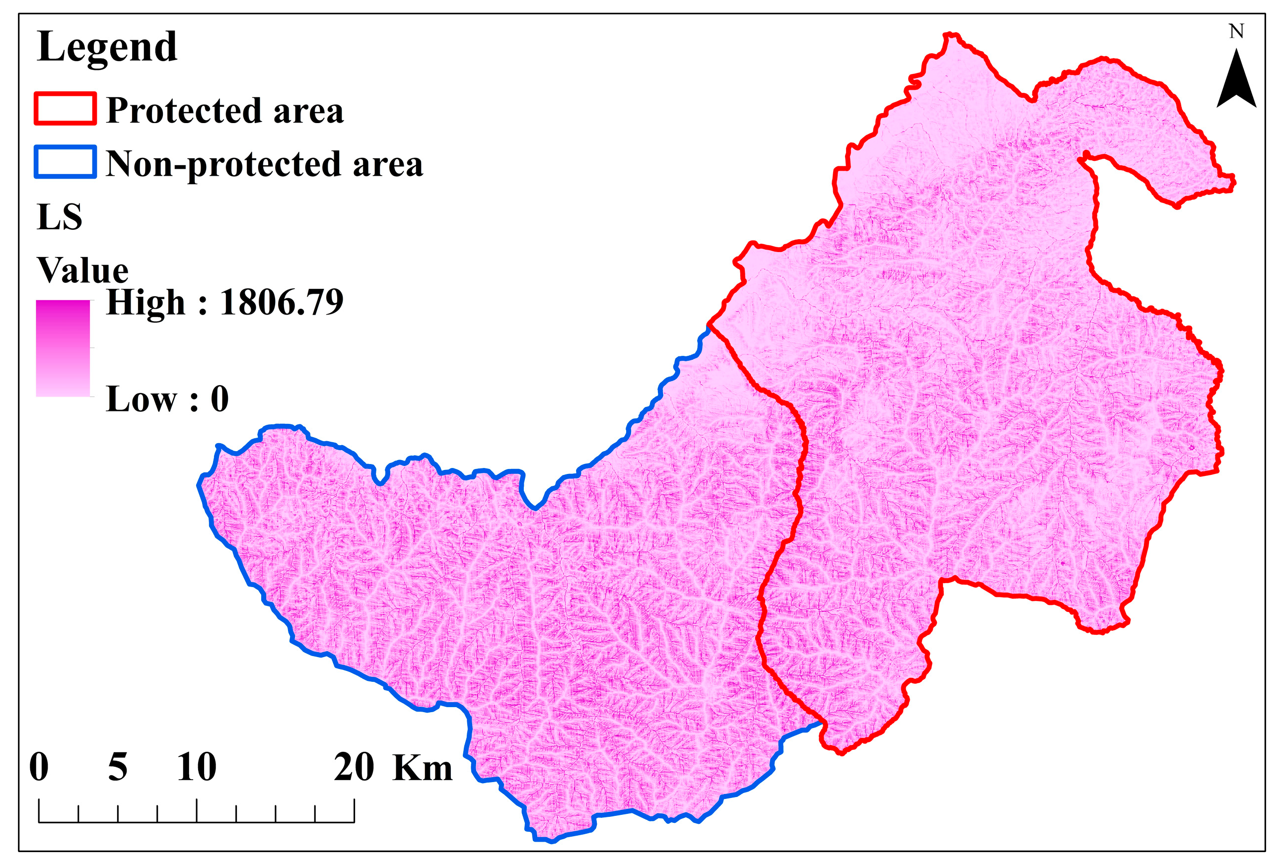
Figure 3 shows the calculated amount for the LS factor in Arasbaran Forests. Based on the obtained data, the majority of the studied sites, the protected region in particular, are located on steep slopes with a high LS value.
Figure 4 also illustrates the developed NDVI for the study regions. The approximate values of 0.9 and −0.6 were achieved as the maximum and minimum values of the NDVI, respectively, which were then applied to extract factor C.
Table 2 presents the results for soil loss drivers, including R, K, LS, C, and P in RUSLE. The constant value of 76.49 (MJ mm hm−2 h−1 year−1) was achieved for rainfall erosivity across the study regions, implying that the region is uniformly affected by precipitation (Table 2). It meant that the region benefits from a homogenous distribution of precipitation that is closely related to its topographic condition and geographic location.
According to Table 2, the amount of the K factor in the non-protected area was higher than that in the protected area, and the mean amount was 0.09 and 0.05 (t hm2 h hm−2 MJ−1 mm−1), respectively. The protected area received a high LS value compared to the non-protected area. The maximum and average values of the LS factor in the protected area were 69% and 22% higher than their values in the non-protected area, respectively (Table 2).
Based on the results, the soil erodibility value was in the range of 0.01–0.24 between study sites, and 0.07 was obtained for the whole study area. Table 3 provides data related to soil erosion across the studied sites. The findings demonstrated the high potential of soil loss for the protected area compared to the non-protected one. According to the results, soil loss ranges from 9.84 and 10.06 tons per hectare/year in protected and non-protected regions, respectively. The high erosion rate was shown in the non-protected area in comparison with the protected one. The average soil erosion rate of 9.95 tons per hectare/year was achieved for the whole of Arasbaran Forests.
The results of the statistical two-way analysis variance of soil erosion are summarized in Table 4. Based on the findings, triple-studied approaches had significant effects on soil erosion.
Table 5 presents the comparison results of the mean soil erosion in terms of management and altitude approaches. The results revealed no significant differences in the average soil erosion between the two regions under the two studied altitude classes.
The results concerning the comparison of the interplay between the two studied approaches (the interactions of dual factors) are provided in Table 6. According to the results, no significant difference was observed in soil erosion between the two studied altitude classes under the two regions.
According to Table 7, the rate of soil erosion based on Morgan’s classification [44], it can be seen that the amount of erosion in both regions is in the middle class. Based on Table 7, it can be seen that the amount of soil erosion in the protected area is in the moderate class, and the non-protected area is in the high class.

4. Discussion

The land-use transformation from forest to agricultural and residential areas and in both protected and non-protected areas, resulting in a reduction in forest quality and fragmentation, causes more soil loss and degradation [45]. Rainfall erosivity is an important driver of soil loss worldwide, which was achieved as a constant value based on the in-suite data for the whole study area. Detailed precipitation data are necessary for detecting the soil loss process more accurately. Therefore, understanding the precipitation patterns, mainly the temporal distribution of heavy rainstorms, is a dominant factor in assessing the erosivity of the rainfall that can profoundly affect the results [46]. Although rainfall erosivity is a highly important factor in the RUSLE, it is the K factor that determines what particles and when they can be detached from the soil surface [47]. The use of the soil map is not effective for drawing significant differences among different soil types and capturing the K factor [46,48]; thus, the soil classification was adopted to calculate this factor in this study.
Based on the results, the low value was shown for the K factor, which is likely caused by a high content of organic matter. Due to the high content of litter produced in the forest ecosystem, the higher organic matter content can negatively affect the K factor, eventually leading to its relative decrease. The lower mean for the erodibility factor (about 0.05) in the protected area can be attributed to the effectiveness of the organic matter. The C factor, which implies the effectivity of management activities, has received higher values in some sampling sites of the protected area while showing the average parity total (Table 1). Although the studied sites included extensive vegetation cover, the calculated NDVI represented no substantial difference between the protected and non-protected areas. The same value for the P factor in both regions outlined its identical role concerning soil loss in the studied sites.
According to the results, the annual soil loss rate in both protected and non-protected areas was 9.84 and 10.06 tons per hectare/year, respectively. This difference appears to be relatively minor. But, this small difference has caused the amount of soil erosion in the unprotected area to be transferred to the higher class. Our findings are consistent with those of other researchers who investigated the impact of various land-use scenarios on soil loss within the Arasbaran Forests using the USLE model. Their study revealed that the transformation of natural rangeland into forest and garden (tree cover) led to a soil loss rate of 9.03 tons per hectare/year [49]. Given the inherent uncertainty regarding the specific contributions of distinct forest areas to soil erosion, it becomes evident that maintaining an annual soil loss rate of 10 tons per hectare/year poses challenges for the forest ecosystem.
The study of the effects of quantitative and qualitative characteristics of forest stands, as well as the soil across the study sites, showed that conservation management had significant effects on soil erosion variability in both protected and non-protected sites [45,50]. Given that the amount of erosion in the non-protected area was slightly greater compared to the protected area, management measures with no direct interference would not effectively preserve the soil and, therefore, will not support all delivery ecosystem services. The slightly higher soil loss in the non-protected area (approximately 0.22 tons per hectare/year) can be attributed to the lower content of organic matter in these areas in comparison to the protected one [45,46]. The non-protected area had been previously under protection, and thus, this area might have benefited from a high level of organic matter content, leading to decreased soil erodibility. Raw organic matter plays a key role in particle stability, which itself can control and decrease soil loss [51]. It is noteworthy that locating the protected area on the steep slopes with spare vegetation cover has increased its susceptibility to soil erosion risk, where the larger value of LS in this area exposes soil to more erosion compared to the non-protected area. Accordingly, our findings are in line with those of previous research [18], indicating that the higher altitude of the location can make the region susceptible to soil loss risk. However, the protected area is strongly influenced by the anthropogenic effect, where easier access for the associated residents and tourists has extensively affected the soil surface and made it susceptible to soil erosion [51].
The results revealed that the RUSLE could approve the variation of soil loss between protected and non-protected regions, which conforms to the results of a previous study. In other words, selecting and using a suitable model such as RUSLE has been successful in estimating soil erosion, and the results can be used by decision-makers [52]. Applying the RUSLE to assess soil loss in rehabilitated mineral land and forest areas, the researchers found that the rate of soil loss in the restored mineral lands was higher than its amount in forest areas.
The findings of this study, as part of a comprehensive study on evaluating the effects of conservation management on some quantitative and qualitative characteristics of Arasbaran Forests, demonstrated no difference between the protected and non-protected areas in terms of health and trunk angle of trees, carbon sequestration, annual growth, soil loss, and diversity of tree species, which matches the results of previous research [49]. The number per hectare, reproduction, diversity of herbaceous species, land-use measures, forest area, and total phosphorus in the non-protected area were even higher compared to the protected one, which is in conformity with the findings of a similar study [43]. It is worth noting that the possible reason for such results is the history of protection in the Arasbaran region. In 1971, the protection of habitats for the black rooster, one of the scarcest birds in the world, was the priority of the protection strategies in Arasbaran Forests; at that time, the current non-protected area served as the protected area. Perhaps if preserving vegetation cover had been the top priority in 1971, the currently unprotected area, with its extensive forest coverage and uninterrupted forested areas situated at higher altitudes, might have held a higher priority for protection. However, at that time, the focus of conservation management was primarily directed towards safeguarding other animal species and maintaining vegetation cover.
Based on the results of this study, the current laws of protection-based management do not significantly affect the rate of soil erosion; thus, it is necessary to review management laws to increase the efficiency of protection in reducing soil erosion in Arasbaran Forests.
Our findings are in accordance with those of research evaluating the effects of land-use changes on the amount of soil loss using the RUSLE in Canada. The results represented that deforestation has increased soil loss and created water quality challenges [10]. Despite the differences in the context, these results are in line with those of previous research, confirming that the mining in the Indian forest areas has increased soil loss [53]. Soil erosion, as a complex process, is affected by sorts of factors; thus, it is expected that by improving management approaches in the protected area (e.g., adopting an integrated approach to prevent deforestation, consolidating conservation laws through infrastructure programs, and increasing the indigenous participation) can reduce soil erosion. Our findings also correspond to another research, implying that the establishment of conservation programs is one of the most important actions for reducing soil erosion in Nepal [54]. It seems that management measures such as forestry interventions and consideration of specific conservation programs for each part of the ecosystem (e.g., soil conservation program, water resource protection, medicinal species protection, and the like), along with the general protective-management policy, are essential in this regard. The management system in the forest area needs to change from the traditional view of conservation without interference with forest resources to conservation with appropriate breeding and management practices.

5. Conclusions

This study employs the Revised Universal Soil Loss Equation (RUSLE) as an empirical model for quantifying soil erosion in conjunction with Remote Sensing (RS) and Geographic Information Systems (GIS) techniques to ascertain soil loss rates within the Arasbaran Forests. RUSLE was selected for its merits, including simplicity, straightforward physical interpretability, minimal data prerequisites, and the capacity to be formulated employing readily available input parameters. This equation has been used by many scientists due to the ease of calculation in relation to soil erosion. Another positive feature of this equation is the ability to use it for different natural ecosystems. However, studies have shown that this model can be more flexible so that erosion can be estimated with a wider range of data in different conditions and situations. In the studied forests, forest protection has been carried out for 45 years, and during this period, any exploitation and interference in this part of the forest has been prohibited. According to the findings, protective measures implemented within the study area exhibit the potential to diminish soil loss by ameliorating soil conditions. Our results reveal that soil erosion is predominantly contingent upon managerial interventions. Given that alterations in natural indicators typically entail a temporal dimension (e.g., soil-related indicators in natural ecosystems), it is anticipated that the sustained application of conservation protocols and regulations will lead to a reduction in soil loss within the protected domain. Soil erosion exerts an adverse impact on forest development, often culminating in the depletion of soil nutrients, such as carbon and nitrogen.
Based on the comparison results of factors between both study sites, as well as other empirical investigations pertaining to soil erosion determinants employing the RUSLE framework, it becomes evident that the LS (Longitudinal Slope) and C (Cover and Management) factors exert the most substantial influence on soil loss within the study area. It becomes apparent that the proactive safeguarding of vegetation in regions characterized by steep topography represents an efficacious strategy for controlling and mitigating erosion rates within these geographic areas. Consequently, in the formulation of management strategies within forested locales, the local attributes, including topography, land cover, and the input of local stakeholders, should be accorded substantial consideration.
The application of the RUSLE model for the estimation of soil erosion has demonstrated notable success in assessing the ramifications of diverse natural ecosystem management practices. In this context, it is imperative to underscore the incorporation of contemporary technologies and methodologies throughout the research process. These technological tools offer heightened capabilities for data acquisition and processing, as well as for the modeling and surveillance of erosion processes, thereby ultimately facilitating more efficient and precise outcomes.
However, there remains room for enhancement, and additional research endeavors may be undertaken to assess the efficacy of diverse conservation measures within the Arasbaran Forests region.

Author Contributions

Investigation, A.B.S., J.E.R., M.M. and P.Á.-Á.; Writing—review & editing, S.S.; Supervision, A.A. All authors have read and agreed to the published version of the manuscript.

Funding

This research received no external funding.

Data Availability Statement

No new data were created or analyzed in this study. Data sharing is not applicable to this article.

Acknowledgments

The first author extend his appreciation to the Urmia University for financing the cost of his thesis.

Conflicts of Interest

The authors declare no conflict of interest.

References

  1. Bozali, N. Assessment of the soil protection function of forest ecosystems using GIS-based Multi-Criteria Decision Analysis: A case study in Adıyaman, Turkey. Glob. Ecol. Conserv. 2020, 24, e01271. [Google Scholar] [CrossRef]
  2. Valderrama, L.; Contreras-Reyes, J.E.; Carrasco, R. Ecological impact of forest fires and subsequent restoration in Chile. Resources 2018, 7, 26. [Google Scholar] [CrossRef]
  3. Nosrati, K.; Collins, A.L. Fingerprinting the contribution of quarrying to fine-grained bed sediment in a mountainous catchment, Iran. River Res. Appl. 2019, 35, 290–300. [Google Scholar] [CrossRef]
  4. Bünemann, E.K.; Bongiorno, G.; Bai, Z.; Creamer, R.E.; De Deyn, G.; De Goede, R.; Fleskens, L.; Geissen, V.; Kuyper, T.W.; Mäder, P. Soil quality–A critical review. Soil Biol. Biochem. 2018, 120, 105–125. [Google Scholar] [CrossRef]
  5. Singh, N.; Parida, B.R.; Charakborty, J.S.; Patel, N. Net ecosystem exchange of CO2 in deciduous pine forest of lower Western Himalaya, India. Resources 2019, 8, 98. [Google Scholar] [CrossRef]
  6. Dou, Y.; Yang, Y.; An, S.; Zhu, Z. Effects of different vegetation restoration measures on soil aggregate stability and erodibility on the Loess Plateau, China. Catena 2020, 185, 104294. [Google Scholar] [CrossRef]
  7. Aneseyee, A.B.; Elias, E.; Soromessa, T.; Feyisa, G.L. Land use/land cover change effect on soil erosion and sediment delivery in the Winike watershed, Omo Gibe Basin, Ethiopia. Sci. Total Environ. 2020, 728, 138776. [Google Scholar] [CrossRef]
  8. Phinzi, K.; Ngetar, N.S.; Ebhuoma, O. Soil erosion risk assessment in the Umzintlava catchment (T32E), Eastern Cape, South Africa, using RUSLE and random forest algorithm. S. Afr. Geogr. J. 2021, 103, 139–162. [Google Scholar] [CrossRef]
  9. Parhizkar, M.; Shabanpour, M.; Zema, D.A.; Lucas-Borja, M.E. Rill erosion and soil quality in forest and deforested ecosystems with different morphological characteristics. Resources 2020, 9, 129. [Google Scholar] [CrossRef]
  10. Paul, S.S.; Li, J.; Li, Y.; Shen, L. Assessing land use–land cover change and soil erosion potential using a combined approach through remote sensing, RUSLE and random forest algorithm. Geocarto Int. 2021, 36, 361–375. [Google Scholar] [CrossRef]
  11. Wassie, S.B. Natural resource degradation tendencies in Ethiopia: A review. Environ. Syst. Res. 2020, 9, 33. [Google Scholar] [CrossRef]
  12. Joshi, V.U. Soil loss estimation based on RUSLE along the Central Hunter Valley Region, NSW, Australia. J. Geol. Soc. India 2018, 91, 554–562. [Google Scholar] [CrossRef]
  13. Sheidai Karkaj, E.; Sepehry, A.; Barani, H.; Motamedi, J.; Shahbazi, F. Establishing a suitable soil quality index for semi-arid rangeland ecosystems in northwest of Iran. J. Soil Sci. Plant Nutr. 2019, 19, 648–658. [Google Scholar] [CrossRef]
  14. Costea, A.; Bilasco, S.; Irimus, I.-A.; Rosca, S.; Vescan, I.; Fodorean, I.; Sestras, P. Evaluation of the Risk Induced by Soil Erosion on Land Use. Case Study: Guruslău Depression. Sustainability 2022, 14, 652. [Google Scholar] [CrossRef]
  15. Ghosal, K.; Bhattacharya, S.D. A Review of RUSLE Model. J. Indian Soc. Remote Sens. 2020, 48, 689–707. [Google Scholar] [CrossRef]
  16. Allafta, H.; Opp, C. Soil erosion assessment using the RUSLE model, remote sensing, and GIS in the Shatt Al-Arab basin (Iraq-Iran). Appl. Sci. 2022, 12, 7776. [Google Scholar] [CrossRef]
  17. Mohammadi, S.; Karimzadeh, H.; Alizadeh, M. Spatial estimation of soil erosion in Iran using RUSLE model. Iran. J. Ecohydrol. 2018, 5, 551–569. [Google Scholar]
  18. Wang, H.; Bai, Y.; Man, X.; Tang, Z.; Zhang, S. Improved RUSLE model to simulate the effect of slope forest area on soil and water conservation. Water Supply 2023, 23, 2799–2813. [Google Scholar] [CrossRef]
  19. Bhattacharya, R.K.; Das Chatterjee, N.; Das, K. Land use and land cover change and its resultant erosion susceptible level: An appraisal using RUSLE and Logistic Regression in a tropical plateau basin of West Bengal, India. Environ. Dev. Sustain. 2021, 23, 1411–1446. [Google Scholar] [CrossRef]
  20. Golijanin, J.; Nikolić, G.; Valjarević, A.; Ivanović, R.; Tunguz, V.; Bojić, S.; Grmuša, M.; Lukić Tanović, M.; Perić, M.; Hrelja, E. Estimation of potential soil erosion reduction using GIS-based RUSLE under different land cover management models: A case study of Pale Municipality, B&H. Front. Environ. Sci. 2022, 10, 945789. [Google Scholar]
  21. Chen, J.; Li, Z.; Xiao, H.; Ning, K.; Tang, C. Effects of land use and land cover on soil erosion control in southern China: Implications from a systematic quantitative review. J. Environ. Manag. 2021, 282, 111924. [Google Scholar] [CrossRef]
  22. Nwaogu, C.; Okeke, O.J.; Assuah Adu, S.; Babine, E.; Pechanec, V. Land use—Land cover change and soil-gully erosion relationships: A study of Nanka, South-Eastern Nigeria using geoinformatics. In Proceedings of the Dynamics in Giscience, Ostrava, Czech Republic, 22–24 March 2017; pp. 305–319. [Google Scholar]
  23. Sadeghi, S.H.R. Soil erosion in Iran: State of the art, tendency and solutions. Poljopr. I Sumar. 2017, 63, 33–37. [Google Scholar]
  24. Börner, J.; Schulz, D.; Wunder, S.; Pfaff, A. The effectiveness of forest conservation policies and programs. Annu. Rev. Resour. Econ. 2020, 12, 45–64. [Google Scholar] [CrossRef]
  25. Talebi, K.S.; Sajedi, T.; Pourhashemi, M. Forests of Iran. A Treasure from the Past, a Hope for the Future; Springer: Berlin/Heidelberg, Germany, 2014; Volume 10. [Google Scholar]
  26. Ghanbari, S.; Turvey, S.T. Local ecological knowledge provides novel evidence on threats and declines for the Caucasian grouse Lyrurus mlokosiewiczi in Arasbaran Biosphere Reserve, Iran. People Nat. 2022, 4, 1536–1546. [Google Scholar] [CrossRef]
  27. Ghanbari, S. Characteristics of Viburnum lantana L., Stands in the Lowest Limit of Its Distribution in the Arasbaran Forests, Iran. ECOPERSIA 2023, 11, 25–36. [Google Scholar]
  28. Barnes, B.V.; Zak, D.R.; Denton, S.R.; Spurr, S.H. Forest Ecology; John Wiley and Sons: Hoboken, NJ, USA, 1997. [Google Scholar]
  29. Wischmeier, W.H.; Smith, D.D. Predicting Rainfall Erosion Losses: A Guide to Conservation Planning; Department of Agriculture, Science and Education Administration, United States Department of Agricolture: Washingtin, DC, USA, 1978. [Google Scholar]
  30. Ferro, V.; Giordano, G.; Iovino, M. Isoerosivity and erosion risk map for Sicily. Hydrol. Sci. J. 1991, 36, 549–564. [Google Scholar] [CrossRef]
  31. Renard, K.G.; Freimund, J.R. Using monthly precipitation data to estimate the R-factor in the revised USLE. J. Hydrol. 1994, 157, 287–306. [Google Scholar] [CrossRef]
  32. de Santos Loureiro, N.; de Azevedo Coutinho, M. A new procedure to estimate the RUSLE EI30 index, based on monthly rainfall data and applied to the Algarve region, Portugal. J. Hydrol. 2001, 250, 12–18. [Google Scholar] [CrossRef]
  33. Diodato, N.; Bellocchi, G. Estimating monthly (R) USLE climate input in a Mediterranean region using limited data. J. Hydrol. 2007, 345, 224–236. [Google Scholar] [CrossRef]
  34. Parysow, P.; Wang, G.; Gertner, G.; Anderson, A.B. Spatial uncertainty analysis for mapping soil erodibility based on joint sequential simulation. Catena 2003, 53, 65–78. [Google Scholar] [CrossRef]
  35. Asadolahi, Z.; Salmanmahiny, A.; Sakieh, Y. Hyrcanian forests conservation based on ecosystem services approach. Environ. Earth Sci. 2017, 76, 365. [Google Scholar] [CrossRef]
  36. Wischmeier, W.H.; Johnson, C.; Cross, B. Soil erodibility nomograph for farmland and construction sites. J. Soil Water Conserv. 1971, 26, 189–193. [Google Scholar]
  37. Haan, C.T.; Barfield, B.J.; Hayes, J.C. Design Hydrology and Sedimentology for Small Catchments; Elsevier: Amsterdam, The Netherlands, 1994. [Google Scholar]
  38. Mccool, D.K.; Brown, L.C.; Foster, G.; Mutchler, C.; Meyer, L. Revised slope steepness factor for the Universal Soil Loss Equation. Trans. ASAE 1987, 30, 1387–1396. [Google Scholar] [CrossRef]
  39. Hrabalíková, M.; Janeček, M. Comparison of different approaches to LS factor calculations based on a measured soil loss under simulated rainfall. Soil Water Res. 2017, 12, 69–77. [Google Scholar] [CrossRef]
  40. Kouli, M.; Soupios, P.; Vallianatos, F. Soil erosion prediction using the revised universal soil loss equation (RUSLE) in a GIS framework, Chania, Northwestern Crete, Greece. Environ. Geol. 2009, 57, 483–497. [Google Scholar] [CrossRef]
  41. Sharma, A.; Tiwari, K.N.; Bhadoria, P. Effect of land use land cover change on soil erosion potential in an agricultural watershed. Environ. Monit. Assess. 2011, 173, 789–801. [Google Scholar] [CrossRef]
  42. Karaburun, A. Estimation of C factor for soil erosion modeling using NDVI in Buyukcekmece watershed. Ozean J. Appl. Sci. 2010, 3, 77–85. [Google Scholar]
  43. Tian, P.; Zhu, Z.; Yue, Q.; He, Y.; Zhang, Z.; Hao, F.; Guo, W.; Chen, L.; Liu, M. Soil erosion assessment by RUSLE with improved P factor and its validation: Case study on mountainous and hilly areas of Hubei Province, China. Int. Soil Water Conserv. Res. 2021, 9, 433–444. [Google Scholar] [CrossRef]
  44. Webster, R. Morgan, RPC Soil Erosion and Conservation, Blackwell Publishing, Oxford, 2005. x+ 304 pp. £ 29.95, paperback. ISBN 1-4051-1781-8. Eur. J. Soil Sci. 2005, 56, 686. [Google Scholar] [CrossRef]
  45. Sasanifar, S.; Alijanpour, A.; Shafiei, A.B.; Rad, J.E.; Molaei, M. Effect of protection based management on physical and chemical properties of soil in Arasbaran forests. Iran. J. For. Poplar Res. 2018, 26, 104–117. [Google Scholar]
  46. Zhu, G.; Tang, Z.; Shangguan, Z.; Peng, C.; Deng, L. Factors affecting the spatial and temporal variations in soil erodibility of China. J. Geophys. Res. Earth Surf. 2019, 124, 737–749. [Google Scholar] [CrossRef]
  47. Polykretis, C.; Alexakis, D.D.; Grillakis, M.G.; Manoudakis, S. Assessment of intra-annual and inter-annual variabilities of soil erosion in Crete Island (Greece) by incorporating the Dynamic “Nature” of R and C-Factors in RUSLE modeling. Remote Sens. 2020, 12, 2439. [Google Scholar] [CrossRef]
  48. Breugem, A.; Wesseling, J.; Oostindie, K.; Ritsema, C. Meteorological aspects of heavy precipitation in relation to floods–an overview. Earth-Sci. Rev. 2020, 204, 103171. [Google Scholar] [CrossRef]
  49. GHahremannejad, E.; Nazarnejad, H.; Miryaghubzadeh, M. Effect of different land-use management scenarios on soil erosion using USLE model in Kalaybarchay watershed. J. Water Soil Resour. Conserv. 2018, 7, 91–104. [Google Scholar]
  50. Sasanifar, S.; Alijanpour, A.; Shafiei, A.B.; Rad, J.E.; Molaei, M.; Azadi, H. Forest protection policy: Lesson learned from Arasbaran biosphere reserve in Northwest Iran. Land Use Policy 2019, 87, 104057. [Google Scholar] [CrossRef]
  51. Liang, Y.; Lehmann, A.; Yang, G.; Leifheit, E.F.; Rillig, M.C. Effects of microplastic fibers on soil aggregation and enzyme activities are organic matter dependent. Front. Environ. Sci. 2021, 9, 650155. [Google Scholar] [CrossRef]
  52. Mahoney, D.; Blandford, B.; Fox, J. Coupling the probability of connectivity and RUSLE reveals pathways of sediment transport and soil loss rates for forest and reclaimed mine landscapes. J. Hydrol. 2021, 594, 125963. [Google Scholar] [CrossRef]
  53. Kayet, N.; Pathak, K.; Chakrabarty, A.; Sahoo, S. Evaluation of soil loss estimation using the RUSLE model and SCS-CN method in hillslope mining areas. Int. Soil Water Conserv. Res. 2018, 6, 31–42. [Google Scholar] [CrossRef]
  54. Thapa, G.; Paudel, G. Farmland degradation in the mountains of Nepal: A study of watersheds ‘with’and ‘without’external intervention. Land Degrad. Dev. 2002, 13, 479–493. [Google Scholar] [CrossRef]
Figure 1. Geographic location of the study area within Iran and east Azerbaijan province.
Forests 14 01942 g001
Figure 2. Flowchart of the study methodology.
Forests 14 01942 g002
Figure 3. LS map created for Arasbaran forests.
Forests 14 01942 g003
Figure 4. NDVI maps generated for Arasbaran forests.
Forests 14 01942 g004
Table 1. The datasets used for the RUSLE modeling.
FactorNameSourceData SourceRequired Data
RRainfall erosivity factor[31]The nearest meteorological station in proximity to the study area.The monthly average rainfall (mm) and the annual average rainfall (mm)
KSoil erodibility factor[36]Soil samples collected from the areaPercentage values for silt, extremely fine sand, organic matter content, soil structure code, and the permeability class of the soil profile
LSTopographic factor [38]Slope map of the region was prepared from the DEM mapGenerated an LS map by creating a flow accumulation map utilizing the Spatial Analyst function and Hydrotools extension, in combination with the generated slope map
CCover and management factor[42]Utilizing Landsat band 4 and 5 images for the sampling period Computed   NDVI   index   using   N D V I = I R R I R + R
PConservation supporting practice factor[43]Assign a value of 0 to areas with implemented soil protection measures and a value of 1 to areas lacking such measures1 is considered a P factor for study area
Table 2. RUSLE factor results.
Soil Erosion FactorsMin.Max.MeanSd
Whole ArasbaranRainfall erosivity factor (R)76.4976.4976.490
Soil erodibility factor (K)0.010.240.070.05
Slope length and slope steepness factor (L.S)082.5922.4419.11
Crop and management factor (C)0.070.160.080.01
Conservation supporting practice factor (P)1111
ProtectedRainfall erosivity factor (R)76.4976.4976.490
Soil erodibility factor (K)0.0110.150.050.04
Slope length and slope steepness factor (L.S)082.5926.9324.78
Crop and management factor (C)0.070.160.080.01
Conservation supporting practice factor (P)1111
Non-protectedRainfall erosivity factor (R)76.4976.4976.490
Soil erodibility factor (K)0.010.240.090.06
Slope length and slope steepness factor (L.S)034.4217.929.53
Crop and management factor (C)0.070.080.080.004
Conservation supporting practice factor (P)1111
Table 3. Average soil erosion (tons per hectare/year) in the studied areas.
Studied RegionErosion (Ton per Hectare/Year)
Protected9.84
Non-protected10.06
Arasbaran9.95
Table 4. Analysis of variance for soil erosion regarding management and altitude approaches.
Change SourcedfSum of SquaresMean SquareFp
Soil erosion (ton per hectare/year)Management approach10.050.050.0030.95 ns
Altitude approach167.3267.320.440.5 ns
Interplay approach1315.67315.672.090.15 ns
Error406020.24150.5
Note. ns: Indicates a statistically insignificant difference.
Table 5. Comparison of mean soil erosion using an independent t-Test corresponding to management and altitude approaches.
Management ApproachAltitude Approach
DescriptionProtectedNon-protectedp1000–1500 masl1500–2000 maslp
Soil erosion (ton per hectare/year)Mean ± Standard error
9.84 ± 3.2910.06 ± 1.730.95 ns11.19 ± 3.258.71 ± 8.270.5 ns
Note. ns: Indicates a statistically insignificant difference.
Table 6. Comparison of mean soil erosion results for protected and non-protected areas by altitude classes.
ProtectedNon-Protected
Altitude (masl)1000–15001500–20001000–15001500–2000
Soil erosion (ton per hectare/year)Mean ± Standard error
13.76 ± 6.13 a5.93 ± 2.2 a8.61 ± 2.35 a11.5 ± 2.58 a
Note. a: Indicates significant differences at the 5% level.
Table 7. Soil erosion classification based on Morgan [43].
Soil Erosion (Ton per Hectare/Year)Erosion Classes
0–2Very slight
2–5slight
5–10Moderate
10–50High
50–100Severe
100–500Very severe
>500Catastrophic
Disclaimer/Publisher’s Note: The statements, opinions and data contained in all publications are solely those of the individual author(s) and contributor(s) and not of MDPI and/or the editor(s). MDPI and/or the editor(s) disclaim responsibility for any injury to people or property resulting from any ideas, methods, instructions or products referred to in the content.

