
A National Map of Snag Hazard to Reduce Risk to Wildland Fire Responders

 , and
, and
Abstract
:1. Introduction
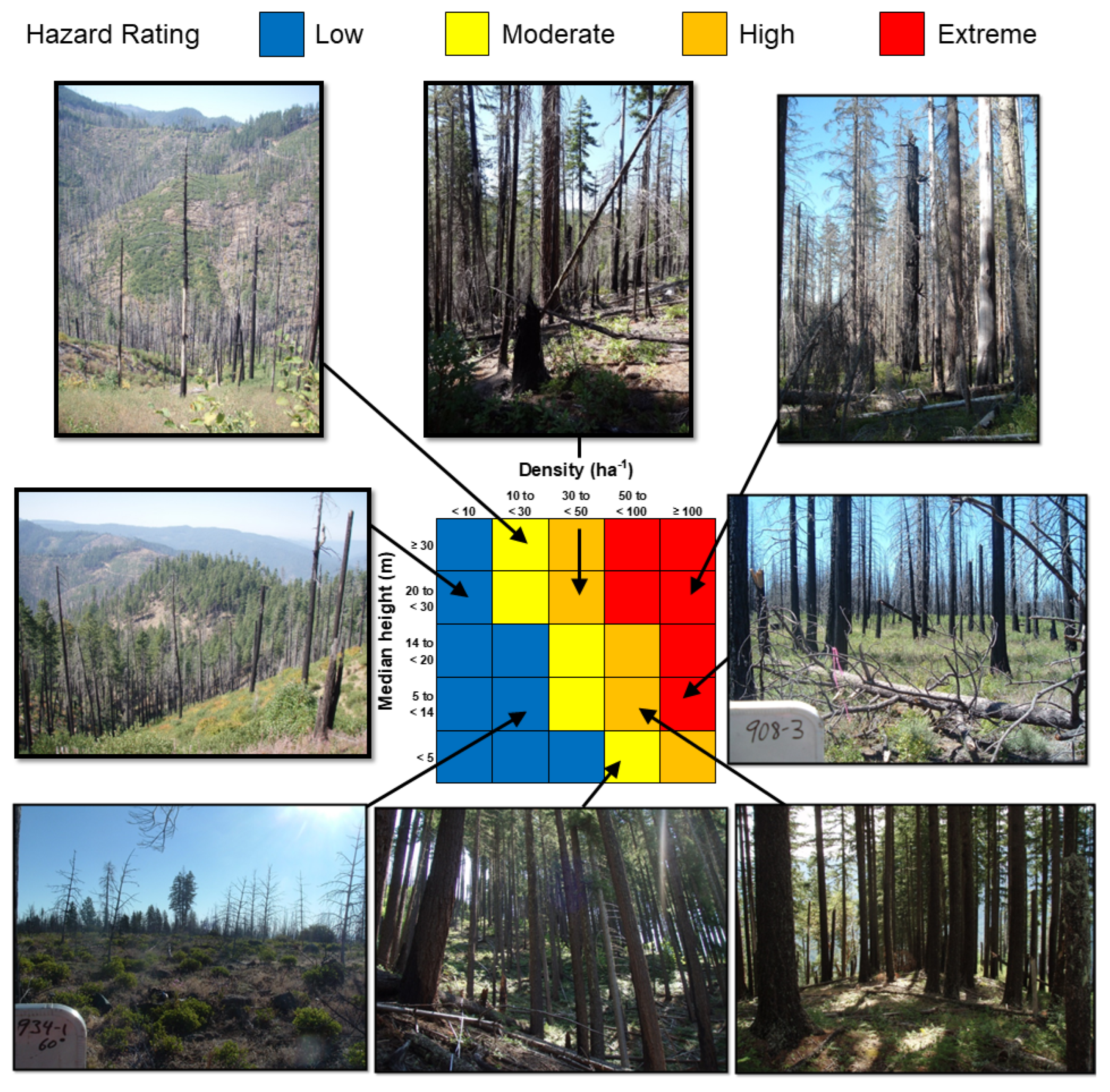
2. Materials and Methods
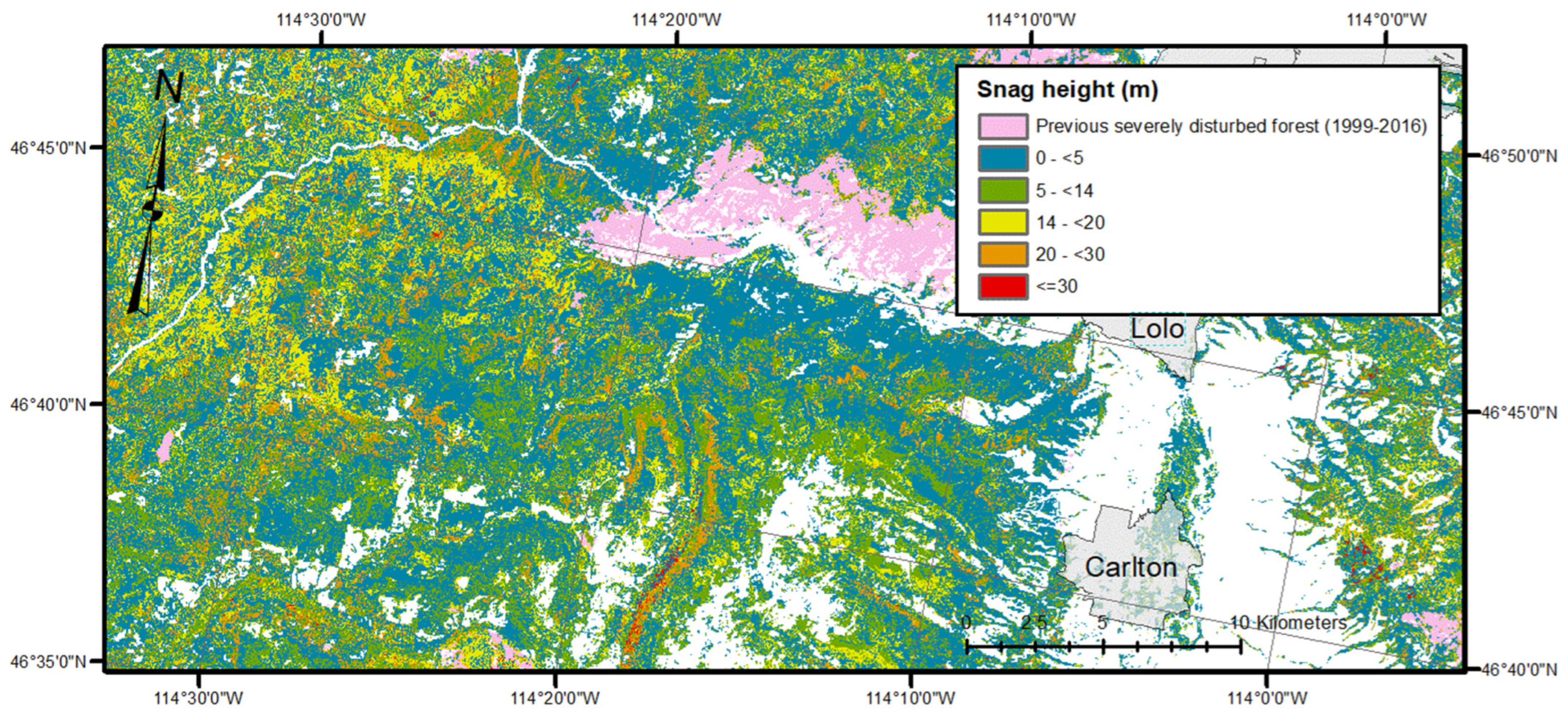
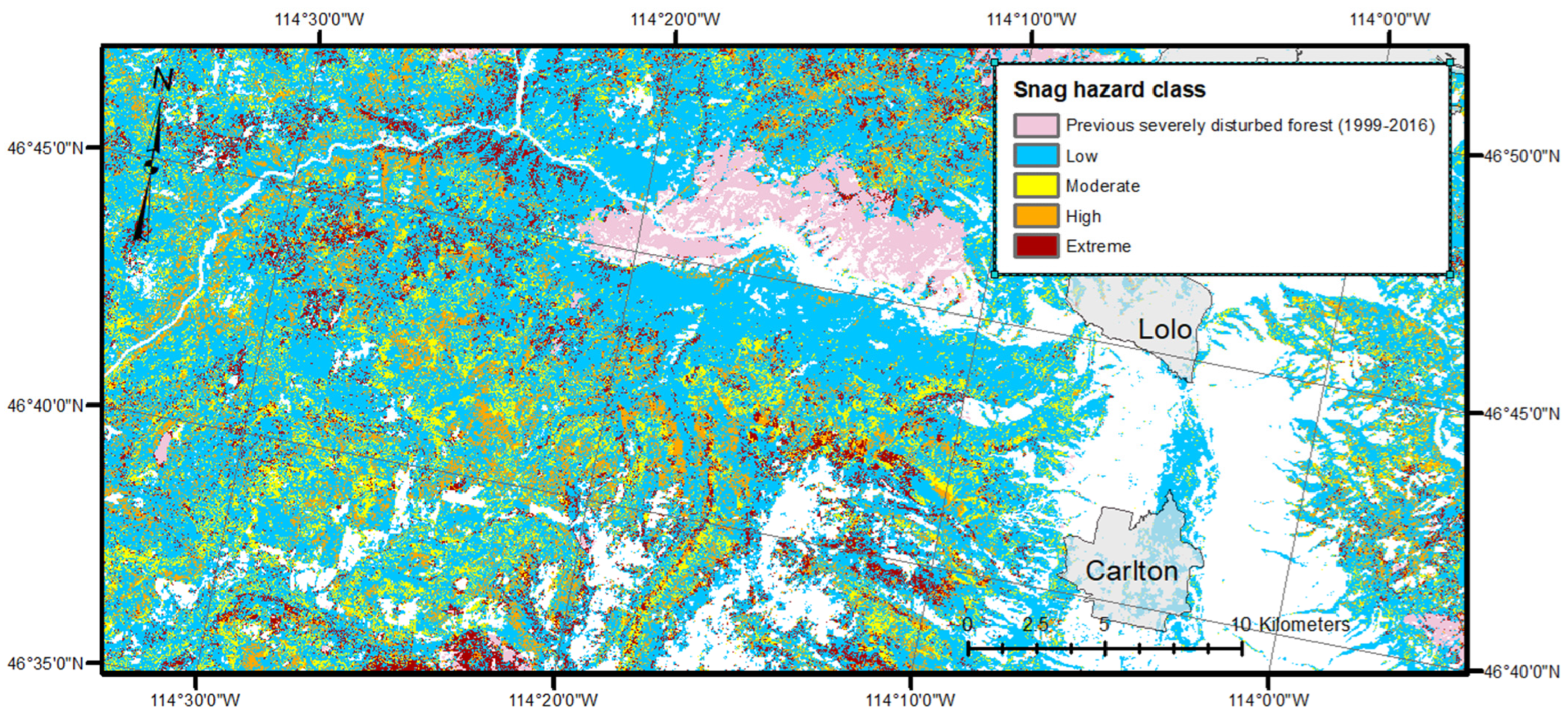
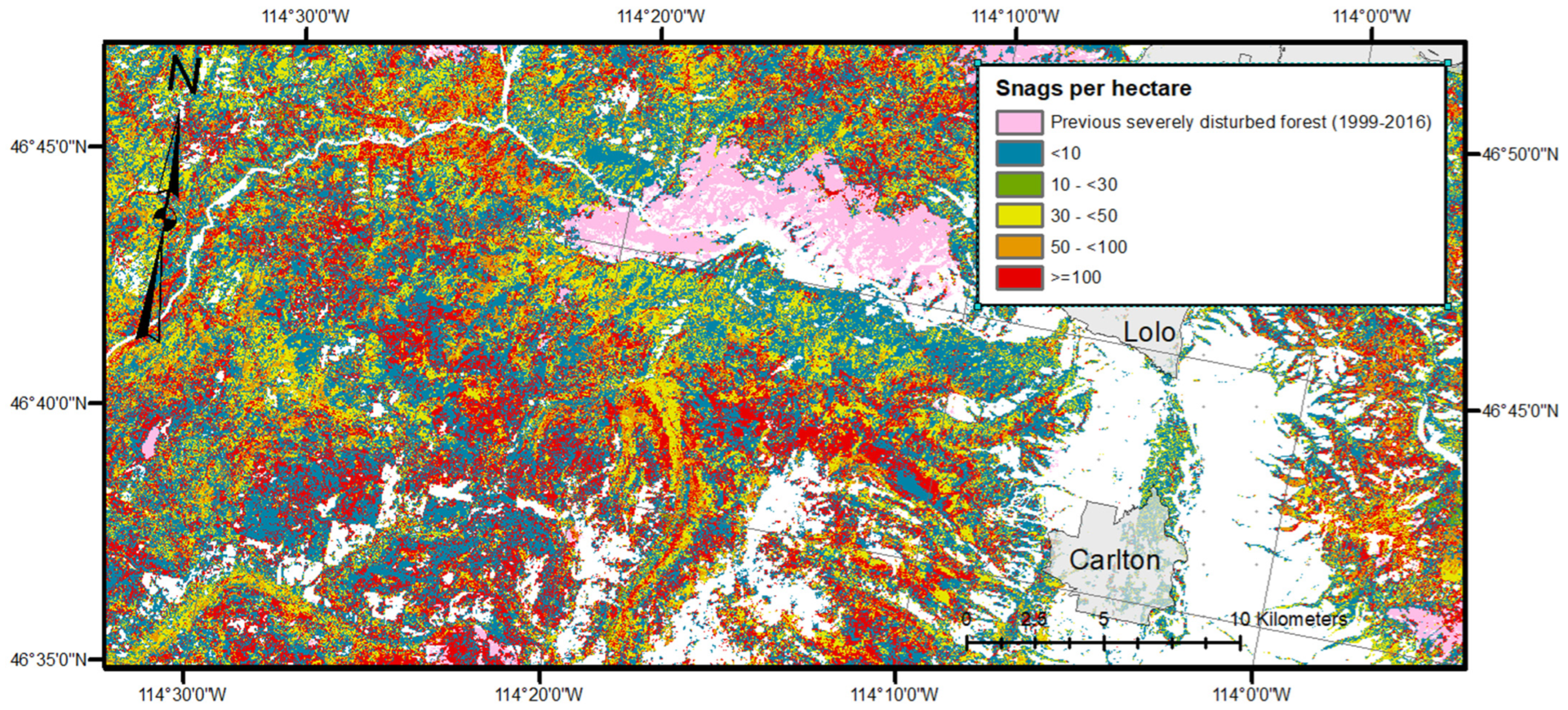
3. Results
3.1. Validation
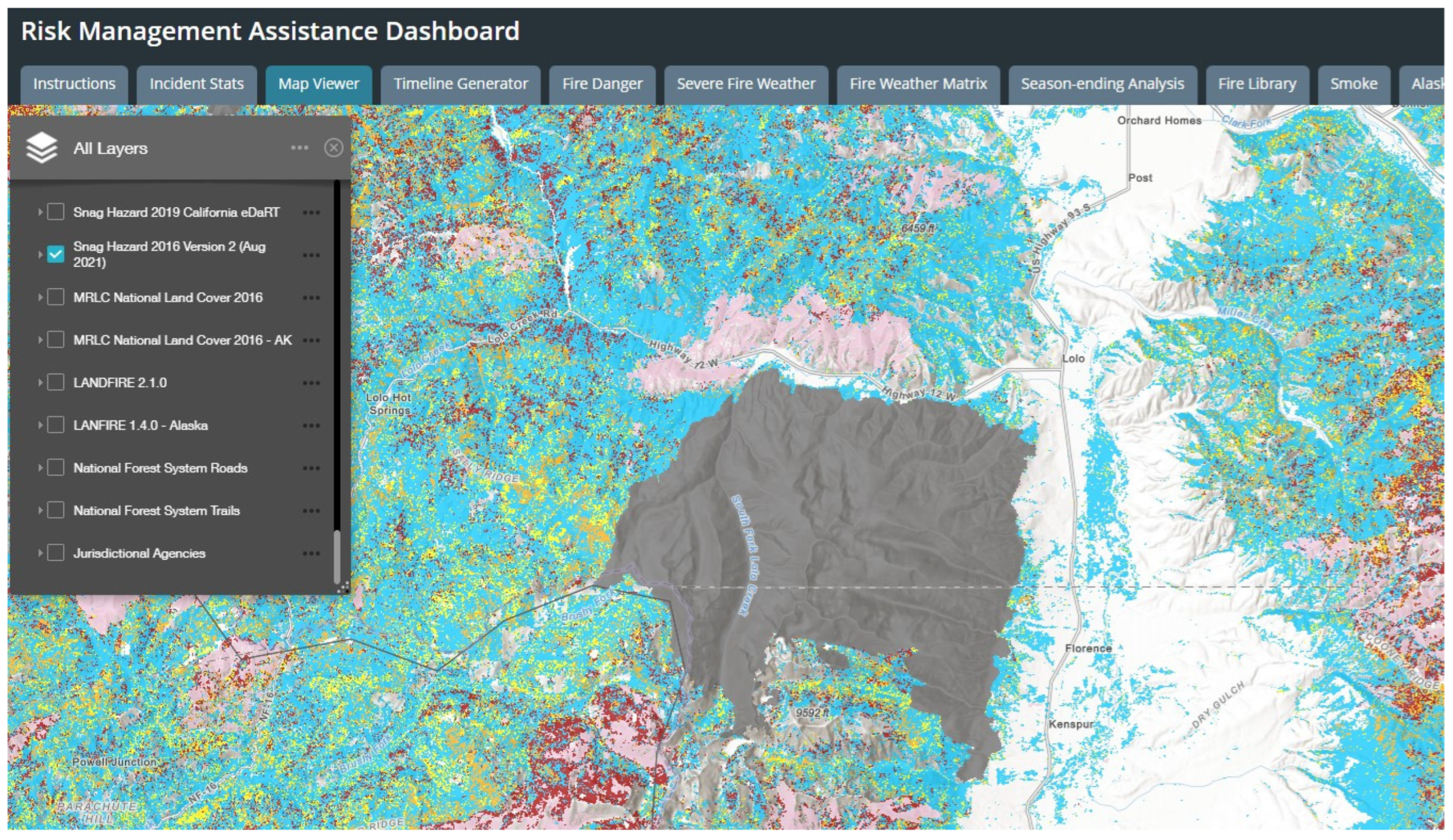
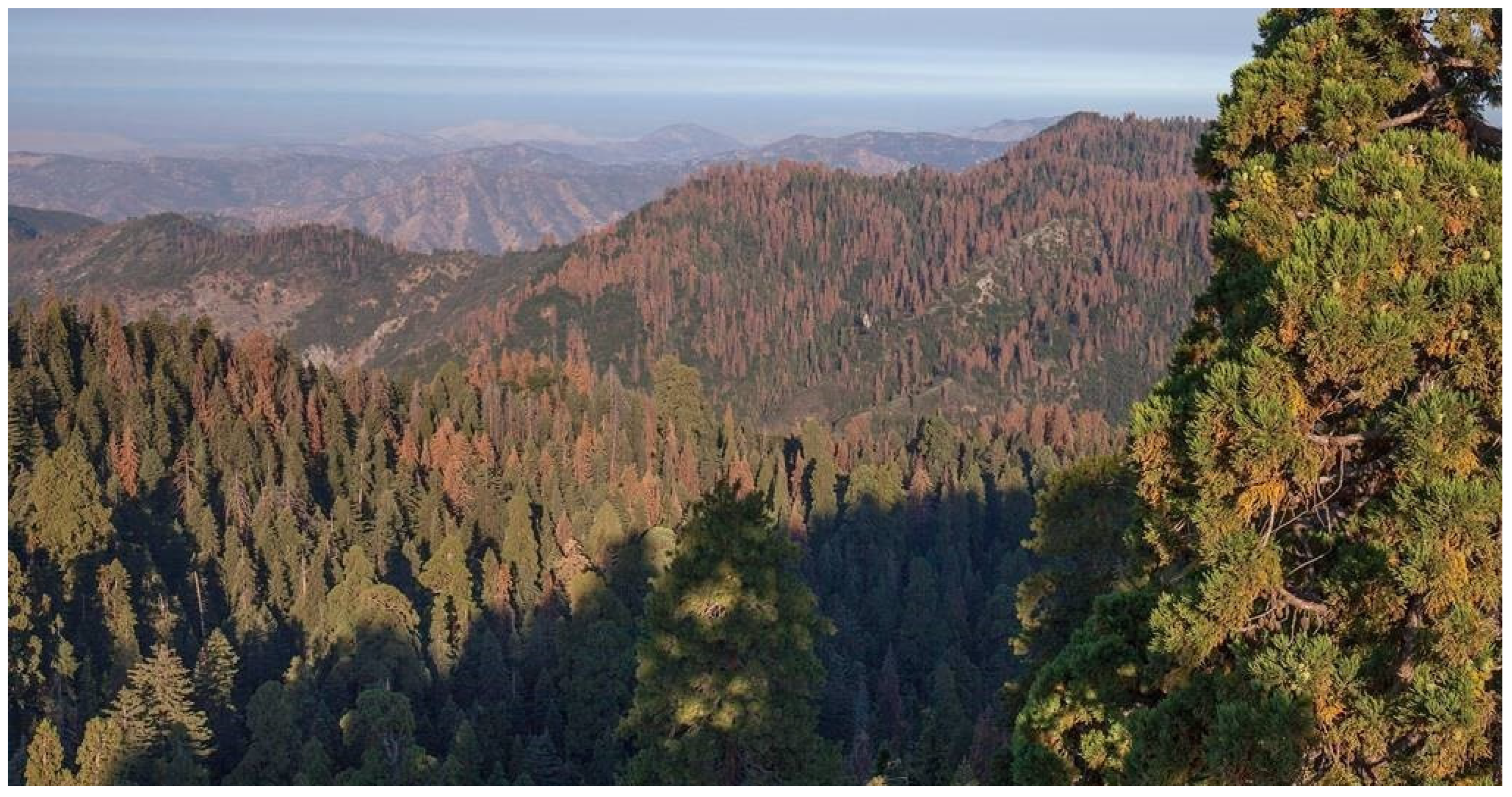
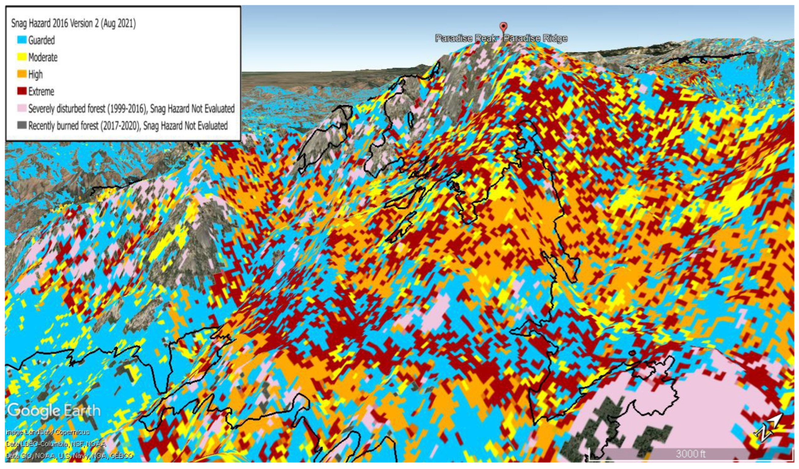
3.2. Application of the Snag Hazard Map
4. Discussion
5. Conclusions
Author Contributions
Funding
Data Availability Statement
Acknowledgments
Conflicts of Interest
References
- van Mantgem, P.J.; Stephenson, N.L.; Byrne, J.C.; Daniels, L.D.; Franklin, J.F.; Fulé, P.Z.; Harmon, M.E.; Larson, A.J.; Smith, J.M.; Taylor, A.H.; et al. Widespread Increase of Tree Mortality Rates in the Western United States. Science 2009, 323, 521–524. [Google Scholar] [CrossRef] [PubMed] [Green Version]
- Abatzoglou, J.T.; Williams, A.P. Impact of anthropogenic climate change on wildfire across western US forests. Proc. Natl. Acad. Sci. USA 2016, 113, 11770–11775. [Google Scholar] [CrossRef] [PubMed] [Green Version]
- Naficy, C.; Sala, A.; Keeling, E.G.; Graham, J.; DeLuca, T.H. Interactive effects of historical logging and fire exclusion on ponderosa pine forest structure in the northern Rockies. Ecol. Appl. 2010, 20, 1851–1864. [Google Scholar] [CrossRef] [PubMed]
- Dunn, C.J.; O’Connor, C.D.; Reilly, M.J.; Calkin, D.E.; Thompson, M.P. Spatial and temporal assessment of responder exposure to snag hazards in post-fire environments. For. Ecol. Manag. 2019, 441, 202–214. [Google Scholar] [CrossRef]
- F.E.M.A. U.S. Fire Administration, Firefighter Fatalities in the United States in 2009. 2010. Available online: https://www.usfa.fema.gov/downloads/pdf/publications/ff_fat09.pdf (accessed on 2 December 2021).
- F.E.M.A. U.S. Fire Administration, Firefighter Fatalities in the United States in 2010. 2011. Available online: https://www.usfa.fema.gov/downloads/pdf/publications/ff_fat10.pdf (accessed on 2 December 2021).
- F.E.M.A. U.S. Fire Administration, Firefighter Fatalities in the United States in 2011. 2012. Available online: https://www.usfa.fema.gov/downloads/pdf/publications/ff_fat11.pdf (accessed on 2 December 2021).
- F.E.M.A. U.S. Fire Administration, Firefighter Fatalities in the United States in 2012. 2013. Available online: https://www.usfa.fema.gov/downloads/pdf/publications/ff_fat12.pdf (accessed on 2 December 2021).
- F.E.M.A. U.S. Fire Administration, Firefighter Fatalities in the United States in 2013. 2014. Available online: https://www.usfa.fema.gov/downloads/pdf/publications/ff_fat13.pdf (accessed on 2 December 2021).
- F.E.M.A. U.S. Fire Administration, Firefighter Fatalities in the United States in 2014. 2015. Available online: https://www.usfa.fema.gov/downloads/pdf/publications/ff_fat14.pdf (accessed on 2 December 2021).
- F.E.M.A. U.S. Fire Administration, Firefighter Fatalities in the United States in 2015. 2016. Available online: https://www.usfa.fema.gov/downloads/pdf/publications/ff_fat15.pdf (accessed on 2 December 2021).
- F.E.M.A. U.S. Fire Administration, Firefighter Fatalities in the United States in 2016. 2017. Available online: https://www.usfa.fema.gov/downloads/pdf/publications/ff_fat16.pdf (accessed on 2 December 2021).
- F.E.M.A. U.S. Fire Administration, Firefighter Fatalities in the United States in 2017. 2018. Available online: https://www.usfa.fema.gov/downloads/pdf/publications/ff_fat17.pdf (accessed on 2 December 2021).
- F.E.M.A. U.S. Fire Administration, Firefighter Fatalities in the United States in 2018. 2019. Available online: https://www.usfa.fema.gov/downloads/pdf/publications/ff_fat18.pdf (accessed on 2 December 2021).
- Gabbert, B. Entrapments is the Fourth Leading Cause of Wildland Firefighter Fatalities. Wildfire Today. 2016. Available online: https://wildfiretoday.com/2016/01/19/entrapments-is-the-fourth-leading-cause-of-wildland-firefighter-fatalities/ (accessed on 29 April 2022).
- Riley, K.L.; Grenfell, I.C.; Finney, M.A.; Shaw, J.D. TreeMap 2016: A tree-Level Model of the Forests of the Conterminous United States Circa 2016; U.S. Department of Agriculture: Fort Collins, CO, USA, 2021. [Google Scholar] [CrossRef]
- Riley, K.L.; Grenfell, I.C.; Finney, M.A.; Wiener, J.M. TreeMap, a tree-level model of conterminous US forests circa 2014 produced by imputation of FIA plot data. Sci. Data 2021, 8, 1–14. [Google Scholar] [CrossRef] [PubMed]
- Riley, K.L.; Grenfell, I.C.; Shaw, J.D.; Finney, M.A. TreeMap 2016 dataset generates CONUS-wide maps of forest characteristics including live basal area, aboveground carbon, and number of trees per acre. J. For. 2022, in press.
- Riley, K.L.; Grenfell, I.C.; Finney, M.A. Mapping forest vegetation for the western United States using modified random forests imputation of FIA forest plots. Ecosphere 2016, 7, e01472. [Google Scholar] [CrossRef]
- Calkin, D.E.; O’Connor, C.D.; Thompson, M.P.; Stratton, R.D. Strategic Wildfire Response Decision Support and the Risk Management Assistance Program. Forests 2021, 12, 1407. [Google Scholar] [CrossRef]
- Risk Management Assistance. Available online: https://wfmrda.nwcg.gov/rma (accessed on 29 April 2022).
- Schultz, C.A.; Miller, L.F.; Greiner, S.M.; Kooistra, C. A Qualitative Study on the US Forest Service’s Risk Management Assistance Efforts to Improve Wildfire Decision-Making. Forests 2021, 12, 344. [Google Scholar] [CrossRef]
- LANDFIRE Data Versions. Available online: https://www.landfire.gov/version_comparison.php (accessed on 2 December 2021).
- Burrill, E.A.; Wilson, A.M.; Turner, J.A.; Pugh, S.A.; Menlove, J.; Christiansen, G.; Conkling, B.L.; David, W. The Forest Inventory and Analysis Database: Database Description and User Guide Version 8.0 for Phase 2; U.S. Department of Agriculture, Forest Service: Washington, DC, USA, 2018; Available online: http://www.fia.fs.fed.us/library/database-documentation/ (accessed on 2 December 2021).
- Risk Management Assistance Risk Management Assistance Dashboard. Available online: https://nifc.maps.arcgis.com/apps/MapSeries/index.html?appid=c5bc811ee22e4da0bde8abec7c20b8b4. (accessed on 1 April 2022).
- Coleman, T.W.; Graves, A.D.; Heath, Z.; Flowers, R.W.; Hanavan, R.P.; Cluck, D.R.; Ryerson, D. Accuracy of aerial detection surveys for mapping insect and disease disturbances in the United States. For. Ecol. Manag. 2018, 430, 321–336. [Google Scholar] [CrossRef]
- Slaton, M.R.; Warren, K.; Koltunov, A.; Smith, S. Chapter 12—Accuracy assessment of Insect and Disease Survey and eDaRT for monitoring forest health. In Forest Health Monitoring: National Status, Trends, and Analysis 2020; Gen. Tech. Rep. SRS-261; U.S. Department of Agriculture Forest Service, Southern Research Station: Asheville, NC, USA, 2021; pp. 187–195. [Google Scholar]
- Koltunov, A.; Ramirez, C.M.; Ustin, S.L.; Slaton, M.; Haunreiter, E. eDaRT: The Ecosystem Disturbance and Recovery Tracker system for monitoring landscape disturbances and their cumulative effects. Remote Sens. Environ. 2020, 238, 111482. [Google Scholar] [CrossRef]
- Rollins, M.G. LANDFIRE: A nationally consistent vegetation, wildland fire, and fuel assessment. Int. J. Wildland Fire 2009, 18, 235–249. [Google Scholar] [CrossRef] [Green Version]
- Hartmann, H.; Schuldt, B.; Sanders, T.G.M.; Macinnis-Ng, C.; Boehmer, H.J.; Allen, C.D.; Bolte, A.; Crowther, T.W.; Hansen, M.C.; Medlyn, B.E.; et al. Monitoring global tree mortality patterns and trends. Report from the VW symposium ‘Crossing scales and disciplines to identify global trends of tree mortality as indicators of forest health. New Phytol. 2018, 217, 984–987. [Google Scholar] [CrossRef] [PubMed] [Green Version]
- Healey, S.P.; Cohen, W.B.; Zhiqiang, Y.; Brewer, K.; Brooks, E.; Gorelick, N.; Gregory, M.; Hernandez, A.; Huang, C.; Hughes, J.; et al. Next-generation forest change mapping across the United States: The landscape change monitoring system (LCMS). In Proceedings of the Pushing Boundaries: New Directions in Inventory Techniques and Applications: Forest Inventory and Analysis (FIA) Symposium 2015, Portland, OR, USA, 8–10 December 2015; Stanton, S.M., Christensen, G.A., Eds.; General Technical Report PNW-GTR-931; U.S. Department of Agriculture, Forest Service, Pacific Northwest Research Station: Portland, Oregon, 2016. [Google Scholar]
- Hartmann, H.; Moura, C.F.; Anderegg, W.R.L.; Ruehr, N.K.; Salmon, Y.; Allen, C.D.; Arndt, S.K.; Breshears, D.D.; Davi, H.; Galbraith, D.; et al. Research frontiers for improving our understanding of drought-induced tree and forest mortality. New Phytol. 2018, 218, 15–28. [Google Scholar] [CrossRef] [PubMed] [Green Version]
- Carroll, A.L.; Taylor, S.W.; Régnière, J.; Safranyik, L. Impacts of climate change on range expansion by the mountain pine beetle. In The Bark Beetles, Fuels, and Fire Bibliography; Paper 195; Canadian Forest Service: Victoria, BC, Canada, 2003. [Google Scholar]
- Bentz, B.J.; Régnière, J.; Fettig, C.J.; Hansen, E.M.; Hayes, J.L.; Hicke, J.A.; Kelsey, R.G.; Negrón, J.F.; Seybold, S.J. Climate Change and Bark Beetles of the Western United States and Canada: Direct and Indirect Effects. BioScience 2010, 60, 602–613. [Google Scholar] [CrossRef]
- Riley, K.L.; Loehman, R.A. Mid-21st-century climate changes increase predicted fire occurrence and fire season length, Northern Rocky Mountains, United States. Ecosphere 2016, 7, e01543. [Google Scholar] [CrossRef]
- Loehman, R.A.; Reinhardt, E.; Riley, K.L. Wildland fire emissions, carbon, and climate: Seeing the forest and the trees—A cross-scale assessment of wildfire and carbon dynamics in fire-prone, forested ecosystems. For. Ecol. Manag. 2014, 317, 9–19. [Google Scholar] [CrossRef]


| Year | Total Number of Fire Responder Deaths | Deaths from Snags |
|---|---|---|
| 2009 | 16 | 1 |
| 2010 | 11 | 1 |
| 2011 | 10 | 0 |
| 2012 | 16 | 0 |
| 2013 | 31 | 0 or 1 (tree status unknown in one case) |
| 2014 | 11 | 0 |
| 2015 | 12 | 0 |
| 2016 | 15 | 1 |
| 2017 | 10 | 2 or 3 (tree status unknown in one case) |
| 2018 | 10 | 1 |
| Year | Incident Name | Description |
|---|---|---|
| 2009 | Freeman Reservoir, CO | One firefighter was struck and killed by a tree while working a hazard tree abatement project. |
| 2010 | Scott’s Chapel Road Fire, KY | One firefighter was clearing a fire break for containment at the base of a bluff when a burning snag broke loose on top and rolled downhill over a small bluff, striking him from behind. The firefighter sustained a serious head injury, fractured hip, bruises, and second-degree burns on his calves. The impact left him unconscious and with serious injuries, including the burns from which he did not recover. |
| 2013 | Electrocution, WA. Unknown whether tree was green or snag. | One inmate firefighter was struck and killed by a falling tree while working as a member of a Washington Department of Natural Resources firefighting crew. |
| 2016 | Strawberry Fire, NV | One firefighter was engaged in tree felling operations on a wildland fire. He was struck by a falling tree as he worked. Firefighters provided treatment, and he was extracted from the scene by helicopter. Upon his arrival at a helibase, he was assessed by paramedics and pronounced deceased. |
| 2017 | Location unknown. Unknown whether tree was green or snag. | One firefighter was leading a crew to clear brush to contain a fire when a 120-foot tree uprooted and fell on him. The firefighter suffered major head, neck, and back injuries. The remote location of the incident posed challenges for medical responders and before aeromedical crews could get to him, the firefighter passed away. |
| 2017 | Florence Fire, MT (later consumed by Rice Ridge Fire) | While part of a 20-person crew that was staging an initial attack on a forest fire in Montana, one firefighter was struck by a falling tree. He was flown to a hospital for treatment, but he passed away from the injuries he sustained when struck by the tree. |
| 2017 | Lolo Peak Fire, MT | One firefighter was struck and killed by a falling tree while working on the Lolo Peak Fire in western Montana. The firefighter was given CPR and other emergency medical aid by fellow firefighters before being airlifted to a hospital. Despite all efforts, the firefighter passed away as a result of his injuries. |
| 2018 | Ferguson Fire, CA | Firefighters were assigned to a wildland fire on the edge of a spot fire. They were in the process of felling a high-hazard tree, a 105-foot tall ponderosa pine that was burning about 10 feet from its top and producing a steady stream of embers. The tree fell in an unexpected manner, and a captain was fatally struck. He was treated by firefighters and emergency medical responders, but he was pronounced dead as he was flown to the helibase. |
| Code | Description |
|---|---|
| 10 | Insect damage |
| 12 | Insect damage to trees, including seedlings and saplings |
| 20 | Disease damage |
| 22 | Disease damage to trees, including seedlings and saplings |
| 30 | Fire damage from crown and ground fire, either prescribed or natural |
| 31 | Ground fire damage |
| 32 | Crown fire damage |
| Characteristic | Accuracy |
|---|---|
| Hazard class | 86.4% |
| Hazard class within disturbed areas | 79.2% |
| Hazard class outside disturbed areas | 87.7% |
| Snag height class | 76.5% |
| Snag density class | 74.4% |
| (a) | ||||||
| Pixel Count (all) | % of Pixels | |||||
| Snag Hazard Class | 2014 | 2016 | 2014 | 2016 | Difference | % of 2014 Value |
| Low (1) | 549,891,348 | 583,978,601 | 68% | 73% | +4% | +6% |
| Moderate (2) | 87,201,007 | 74,700,091 | 11% | 9% | −2% | −14% |
| High (3) | 86,178,261 | 76,152,402 | 11% | 9% | −1% | −12% |
| Extreme (4) | 81,537,599 | 69,977,121 | 10% | 9% | −1% | −14% |
| (b) | ||||||
| Pixel Count (disturbed) | % of Pixels | |||||
| Snag Hazard Class | 2014 | 2016 | 2014 | 2016 | Difference | % of 2014 Value |
| Low (1) | 48,417,786.00 | 38,079,050.00 | 68% | 54% | −15% | −21% |
| Moderate (2) | 7,960,232.00 | 9,488,766.00 | 11% | 13% | +2% | +19% |
| High (3) | 6,917,520.00 | 8,924,158.00 | 10% | 13% | +3% | +29% |
| Extreme (4) | 7,759,094.00 | 14,562,658.00 | 11% | 20% | +10% | +88% |
Publisher’s Note: MDPI stays neutral with regard to jurisdictional claims in published maps and institutional affiliations. |
© 2022 by the authors. Licensee MDPI, Basel, Switzerland. This article is an open access article distributed under the terms and conditions of the Creative Commons Attribution (CC BY) license (https://creativecommons.org/licenses/by/4.0/).
Share and Cite
Riley, K.L.; O’Connor, C.D.; Dunn, C.J.; Haas, J.R.; Stratton, R.D.; Gannon, B. A National Map of Snag Hazard to Reduce Risk to Wildland Fire Responders. Forests 2022, 13, 1160. https://doi.org/10.3390/f13081160
Riley KL, O’Connor CD, Dunn CJ, Haas JR, Stratton RD, Gannon B. A National Map of Snag Hazard to Reduce Risk to Wildland Fire Responders. Forests. 2022; 13(8):1160. https://doi.org/10.3390/f13081160
Chicago/Turabian StyleRiley, Karin L., Christopher D. O’Connor, Christopher J. Dunn, Jessica R. Haas, Richard D. Stratton, and Benjamin Gannon. 2022. "A National Map of Snag Hazard to Reduce Risk to Wildland Fire Responders" Forests 13, no. 8: 1160. https://doi.org/10.3390/f13081160
APA StyleRiley, K. L., O’Connor, C. D., Dunn, C. J., Haas, J. R., Stratton, R. D., & Gannon, B. (2022). A National Map of Snag Hazard to Reduce Risk to Wildland Fire Responders. Forests, 13(8), 1160. https://doi.org/10.3390/f13081160