
Modeling Merchantable Wood Volume Using Airborne LiDAR Metrics and Historical Forest Inventory Plots at a Provincial Scale

Abstract
:1. Introduction
2. Materials and Methods
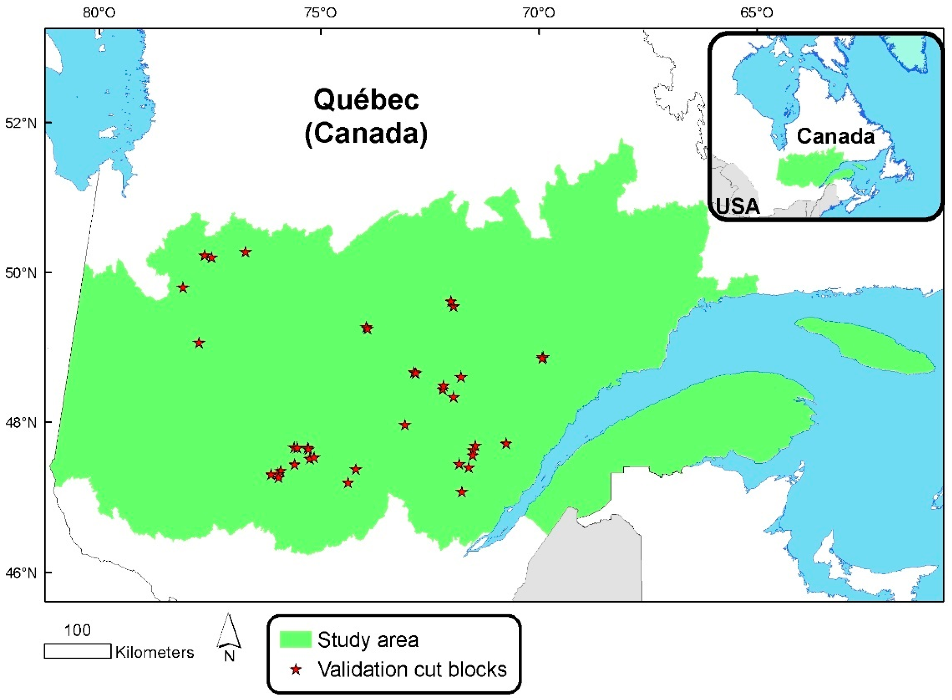
2.1. Study Area
2.2. Data
2.2.1. Airborne LiDAR Data
2.2.2. Ground Sample Plots
2.2.3. Ground Plots Synchronous with LiDAR
2.2.4. Cut Blocks
2.2.5. Ecoforest and Ecological Land Classification
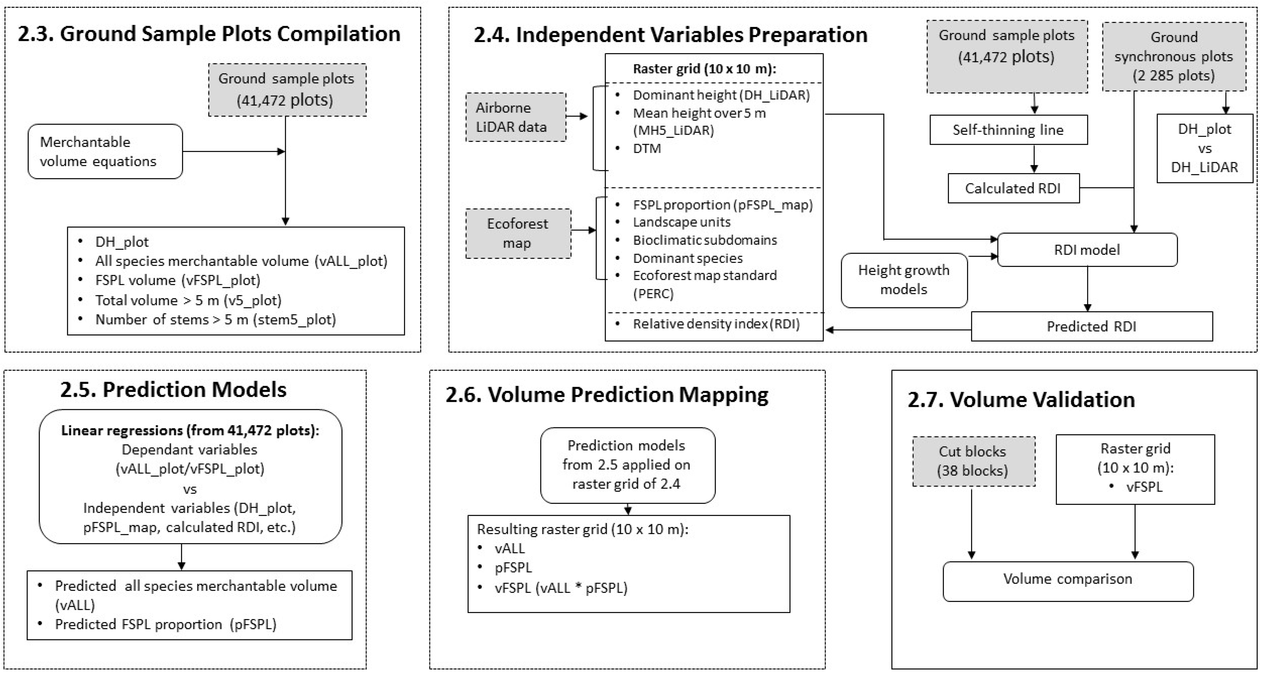
2.3. Ground Sample Plots Compilation
2.3.1. Dominant Height Ground Sample Plot Compilations
2.3.2. Dependent Variables
2.4. Independent Variables Preparation
2.5. Prediction Models
2.6. Volume Prediction Mapping
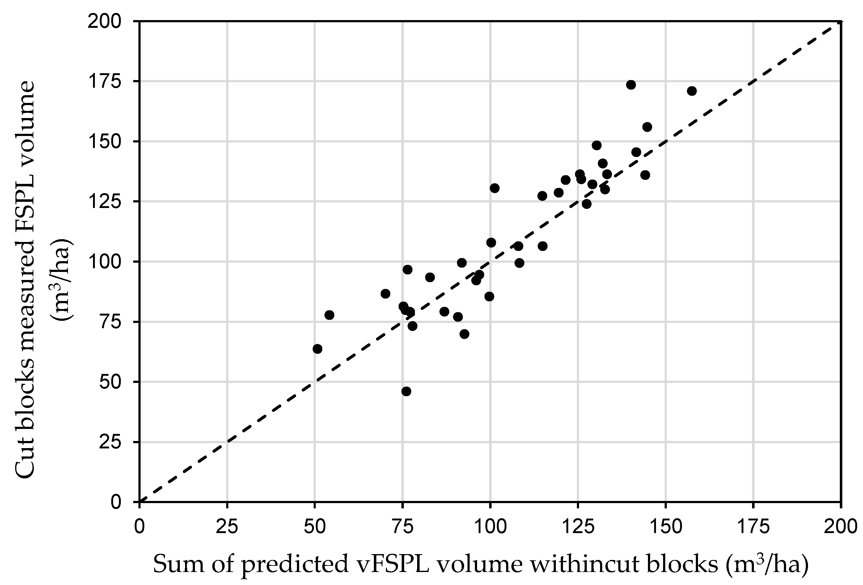
2.7. Volume Validation
3. Results
3.1. LiDAR Preparation Data
3.2. DH_plot vs. DH_LiDAR
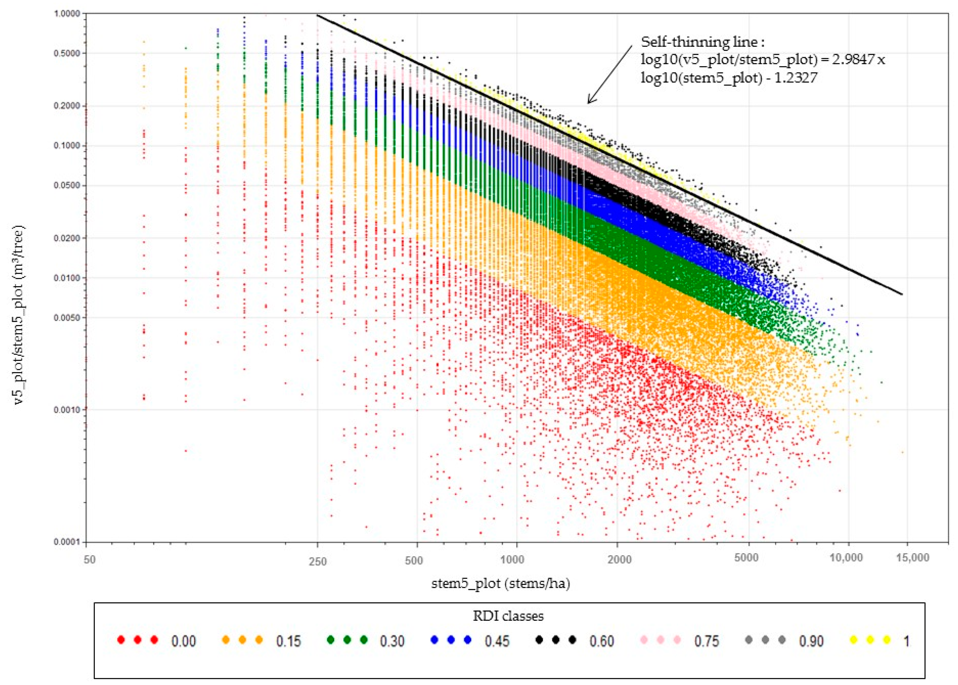
3.3. RDI
3.3.1. RDI Self-Thinning
3.3.2. RDI Model
3.4. Prediction Models
3.5. Validation
4. Discussion
5. Conclusions
Author Contributions
Funding
Institutional Review Board Statement
Informed Consent Statement
Data Availability Statement
Acknowledgments
Conflicts of Interest
References
- MFFP. Guide D’utilisation des Produits Dérivés du LiDAR. Available online: https://mffp.gouv.qc.ca/documents/forets/inventaire/guide-interpretation-lidar.pdf (accessed on 16 September 2021).
- Hyyppä, J.; Yu, X.; Hyyppä, H.; Vastaranta, M.; Holopainen, M.; Kukko, A.; Kaartinen, H.; Jaakkola, A.; Vaaja, M.; Koskinen, J.; et al. Advances in Forest Inventory Using Airborne Laser Scanning. Remote Sens. 2012, 4, 1190–1207. [Google Scholar] [CrossRef] [Green Version]
- Treitz, P.; Lim, K.; Woods, M.; Pitt, D.; Nesbitt, D.; Etheridge, D. Lidar Sampling Density for Forest Resource Inventories in Ontario, Canada. Remote Sens. 2012, 4, 830–848. [Google Scholar] [CrossRef] [Green Version]
- Wulder, M.A.; Bater, C.W.; Coops, N.C.; Hilker, T.; White, J.C. The role of Lidar in sustainable forest management. Forest Chron. 2008, 84, 807–826. [Google Scholar] [CrossRef] [Green Version]
- Bouvier, M.; Durrieu, S.; Fournier, R.A.; Renaud, J.-P. Generalizing predictive models of forest inventory attributes using an area-based approach with airborne Lidar data. Remote Sens. Environ. 2015, 156, 322–334. [Google Scholar] [CrossRef]
- Means, J.; Acker, S.; Fitt, B.; Renslow, M.; Emerson, L.; Hendrix, C. Predicting forest stand characteristics with airborne scanning LiDAR. PE&RS 2000, 66, 1367–1371. [Google Scholar]
- Næsset, E. Predicting forest stand characteristics with airborne scanning laser using a practical two-stage procedure and field data. Remote Sens. Environ. 2002, 80, 88–99. [Google Scholar] [CrossRef]
- Woods, M.; Pitt, D.; Penner, M.; Lim, K.; Nesbitt, D.; Etheridge, D.; Treitz, P. Operational implementation of a Lidar inventory in Boreal Ontario. For. Chron. 2011, 87, 512–528. [Google Scholar] [CrossRef]
- NRCAN. A Best Practices Guide for Generating Forest Inventory Attributes from Airborne Laser Scanning Data Using an Area-based Approach. Available online: https://cfs.nrcan.gc.ca/publications/download-pdf/34887 (accessed on 30 September 2021).
- Hudak, A.T.; Crookston, N.L.; Evans, J.S.; Hall, D.E.; Falkowski, M.J. Nearest neighbor imputation of species-level, plot-scale forest structure attributes from LiDAR data. Remote Sens. Environ. 2008, 112, 2232–2245. [Google Scholar] [CrossRef] [Green Version]
- McInerney, D.; Nieuwenhuis, M. A comparative analysis of kNN and decision tree methods for the Irish National Forest Inventory. Int. J. Remote Sens. 2009, 30, 4937–4955. [Google Scholar] [CrossRef]
- Adams, T.; Brack, C.; Farrier, T.; Pont, D.; Brownlie, R. So you want to use Lidar? A guide on how to use Lidar in forestry. N. Z. J. For. 2011, 55, 19–23. [Google Scholar]
- Frazer, G.W.; Magnussen, S.; Wulder, M.A.; Niemann, K.O. Simulated impact of sample plot size and co-registration error on the accuracy and uncertainty of Lidar-derived estimates of forest stand biomass. Remote Sens. Environ. 2011, 115, 636–649. [Google Scholar] [CrossRef]
- Montgomery, D.C.; Peck, E.A.; Vining, G.G. Introduction to Linear Regression Analysis, 5th ed.; John Wiley & Sons: New York, NY, USA, 2006; 672p. [Google Scholar]
- Magnussen, S.; Næsset, E.; Gobakken, T. Reliability of Lidar derived predictors of forest inventory attributes: A case study with Norway spruce. Remote Sens. Environ. 2010, 114, 700–712. [Google Scholar] [CrossRef]
- Gobakken, T.; Næsset, E. Assessing effects of laser point density, ground sampling intensity, and field sample plot size on biophysical stand properties derived from airborne laser scanner data. Can. J. For. Res. 2008, 38, 1095–1109. [Google Scholar] [CrossRef]
- Coops, N.C.; Tompalski, P.; Goodbody, T.R.H.; Queinnec, M.; Luther, J.E.; Bolton, D.K.; White, J.C.; Wulder, M.A.; Van Lier, O.R.; Hermosilla, T. Modelling lidar-derived estimates of forest attributes over space and time: A review of approaches and future trends. Remote Sens. Environ. 2021, 260, 112477. [Google Scholar] [CrossRef]
- MFFP. Classification Écologique du Territoire Québécois. Available online: https://mffp.gouv.qc.ca//documents/forets/inventaire/classification_ecologique_territoire_quebecois.pdf (accessed on 23 November 2021).
- Baldwin, K.; Allen, L.; Basquill, S.; Chapman, K.; Downing, D.; Flynn, N.; MacKenzie, W.; Major, M.; Meades, W.; Meidinger, D.; et al. Vegetation Zones of Canada: A Biogeoclimatic Perspective; Information Report, GLC-X-25; Canadian Forest Service: Sault Ste Marie, ON, Canada, 2021. [Google Scholar]
- MFFP. Normes D’inventaire Forestier: Placettes-Échantillons Permanentes. Available online: https://mffp.gouv.qc.ca/documents/forets/inventaire/norme-5e-inventaire-peppdf.pdf (accessed on 16 September 2021).
- MFFP. Normes D’inventaire Écoforestier: Placettes-Échantillons Temporaires. Available online: https://mffp.gouv.qc.ca/documents/forets/inventaire/Norme_PET_5e.pdf (accessed on 16 September 2021).
- Robitaille, A.; Saucier, J.-P. Paysages Régionaux du Québec Méridional; Les Publications du Québec: Québec, QC, Canada, 1998; 213p. [Google Scholar]
- MRNF. Méthodes de Mesurage des Bois. Instructions Techniques. Exercice 2011–2012. Available online: https://numerique.banq.qc.ca/patrimoine/details/52327/21117?docref=BXYItiZ193KhaBXrjEGF3w (accessed on 16 September 2021).
- MRN. Inventaire de la Matière Ligneuse Utilisable Mais non Récoltée dans les Aires de Coupe. Instructions. Available online: https://mffp.gouv.qc.ca/publications/forets/entreprises/matli.pdf (accessed on 16 September 2021).
- MFFP. Norme de Stratification Écoforestière, Quatrième Inventaire Écoforestier du Québec Méridional. Available online: https://mffp.gouv.qc.ca/documents/forets/inventaire/norme-stratification.pdf (accessed on 30 September 2021).
- MFFP. 5e Inventaire Écoforestier du Québec Méridional, Bilan des Orientations Retenues et des Travaux de mise en Oeuvre. Available online: https://mffp.gouv.qc.ca/documents/forets/inventaire/bilan-orientations.pdf (accessed on 30 September 2021).
- MFFP. Cartographie du Cinquième Inventaire Écoforestier du Québec Méridional. Available online: https://mffp.gouv.qc.ca/documents/forets/inventaire/carto_5E_methodes_donnees.pdf (accessed on 30 September 2021).
- Rondoux, J. La Mesure des Arbres et des Peuplements Forestiers; Les Presses de l’Université de Liège: Liège, Belgium, 2021; 737p. [Google Scholar]
- IUFRO. The Standardization of Symbols in Forest Mensuration; Technical Bulletin 15; University of Maine, Agricultural Experimental Station: Orono, ME, USA, 1965; 32p. [Google Scholar]
- Fortin, M.; DeBlois, J.; Bernier, S.; Blais, G. Mise au point d’un tarif de cubage général pour les forêts québécoises: Une approche pour mieux évaluer l’incertitude associée aux prévisions. For. Chron. 2007, 83, 754–765. [Google Scholar] [CrossRef]
- Auger, I. Une Nouvelle Relation Hauteur-Diamètre Tenant Compte de L’influence de la Station et du Climat Pour 27 Essences Commerciales du Québec. Available online: https://mffp.gouv.qc.ca/documents/forets/connaissances/recherche/Note146.pdf (accessed on 30 September 2021).
- Fradette, M.-S.; Leboeuf, A.; Riopel, M.; Bégin, J. Method to Reduce the Bias on Digital Terrain Model and Canopy Height Model from LiDAR. Remote Sens. 2019, 11, 863. [Google Scholar] [CrossRef] [Green Version]
- Franceschi, S.; Antonello, A.; Floreancig, V.; Gianelle, D.; Comiti, F.; Tonon, G. Identifying tree tops from aerial laser scanning data with particle swarming optimization. Eur. J. Remote Sens. 2018, 51, 945–964. [Google Scholar] [CrossRef] [Green Version]
- Laflèche, V.; Bernier, S.; Saucier, J.-P.; Gagné, C. Indices de Qualité de Station des Principales Essences Commerciales en Fonction des Types Écologiques du Québec Méridional. Available online: https://mffp.gouv.qc.ca/documents/forets/inventaire/indices-qualite.pdf (accessed on 30 September 2021).
- Girard, C.; Ouarda, T.; Bobée, B. Étude du biais dans le modèle log-linéaire d’estimation régionale. Can. J. Civ. Eng. 2004, 31, 361–368. [Google Scholar] [CrossRef]
- Finney, D.J. On the distribution of a variate whose logarithm is normally distributed. J. Roy. Stat. Soc. Suppl. 1941, 7, 155–161. [Google Scholar] [CrossRef]
- Beauchamp, J.J.; Olson, J.S. Corrections for Bias in Regression Estimates After Logarithmic Transformation. Ecology 1973, 54, 1403–1407. Available online: https://can01.safelinks.protection.outlook.com/?url=https%3A%2F%2Fdoi.org%2F10.2307%2F1934208&data=05%7C01%7CAntoine.Leboeuf%40mffp.gouv.qc.ca%7C4e70f28818044606cb3908da23b6d1f4%7C8705e97737814f4790e1c84c8b884da1%7C0%7C0%7C637861565349383242%7CUnknown%7CTWFpbGZsb3d8eyJWIjoiMC4wLjAwMDAiLCJQIjoiV2luMzIiLCJBTiI6Ik1haWwiLCJXVCI6Mn0%3D%7C3000%7C%7C%7C&sdata=B%2BbAmOJski%2FWJP4u0R%2Fe%2F7LVkG2sxLMneRSWftB0J%2F4%3D&reserved=0 (accessed on 30 September 2021). [CrossRef]
- Yu, X.; Hyyppä, J.; Hyyppä, H.; Maltamo, M. Effects of flight altitude on tree height estimation using airborne laser scanning. Arch. Photogramm. Remote Sens. Spat. Inf. Sci. 2004, 36, 96–101. [Google Scholar]
- Næsset, E.; Okland, T. Estimating tree height and tree crown properties using airborne scanning laser in a boreal nature reserve. Remote Sens. Environ. 2002, 79, 105–115. [Google Scholar] [CrossRef]
- Hulshof, C.; Swenson, N.; Weiser, M. Tree height–diameter allometry across the United States. Ecol. Evol. 2015, 6, 1193–1204. [Google Scholar] [CrossRef] [PubMed]
- White, J.; Coops, N.; Wulder, M.; Vastaranta, M.; Hilker, T.; Tompalski, P. Remote Sensing Technologies for Enhancing Forest Inventories: A Review. Can. J. Remote Sens. 2016, 42, 619–641. [Google Scholar] [CrossRef] [Green Version]


| Characteristics | Specifications |
|---|---|
| Sensor types | ALS70 (Leica, Leica Geosystems AG, Heerbrugg, Switzerland), ALTM Gemini (Optech, Teledyne Optech Inc., Vaughan, Canada), ALTM Galaxy Prime (Optech, Teledyne Optech Inc., Vaughan, Canada), ALTM 3100 (Optech, Teledyne), LMS-Q680i (Riegl, RIEGL Laser Measurement Systems GmbH, Riedenburgstraße, Austria), LMS-780 (RIEGL Laser Measurement Systems GmbH, Riedenburgstraße, Austria) |
| Pulse repetition rate | 100–400 kHz |
| Scan angles | 0–20 degrees |
| Horizontal (X, Y) accuracy | 0–0.50 m (confidence interval of 68%) |
| Vertical (Z) accuracy | 0–0.25 m (confidence interval of 68%) |
| Horizontal (X, Y) datum | NAD 83 (CSRS) |
| Vertical (Z) datum | CGVD28 |
| Strip overlap | >20% |
| Number of returns per pulse | ≥4 |
| Pulse density | 2–6 pulses/m² |
| Variable | Signification and Measurement Unit | Mean (St. Dev.) | Min. | Max. |
|---|---|---|---|---|
| vALL_plot | Merchantable volume for all species (m3/ha) | 113.1 (71.0) | 0.1 | 653.5 |
| vFSPL_plot | Merchantable volume for fir–spruce–pine–larch group (m3/ha) | 71.9 (58.5) | 0.0 | 432.5 |
| v5_plot | Total volume (all species) above a threshold of 5 m (m3/ha) | 48.9 (38.6) | 0.0 | 430.2 |
| stem5_plot | Number of stems higher than 5 m (ha−1) | 1990.4 (1320.0) | 25 | 14,525 |
Publisher’s Note: MDPI stays neutral with regard to jurisdictional claims in published maps and institutional affiliations. |
© 2022 by the authors. Licensee MDPI, Basel, Switzerland. This article is an open access article distributed under the terms and conditions of the Creative Commons Attribution (CC BY) license (https://creativecommons.org/licenses/by/4.0/).
Share and Cite
Leboeuf, A.; Riopel, M.; Munger, D.; Fradette, M.-S.; Bégin, J. Modeling Merchantable Wood Volume Using Airborne LiDAR Metrics and Historical Forest Inventory Plots at a Provincial Scale. Forests 2022, 13, 985. https://doi.org/10.3390/f13070985
Leboeuf A, Riopel M, Munger D, Fradette M-S, Bégin J. Modeling Merchantable Wood Volume Using Airborne LiDAR Metrics and Historical Forest Inventory Plots at a Provincial Scale. Forests. 2022; 13(7):985. https://doi.org/10.3390/f13070985
Chicago/Turabian StyleLeboeuf, Antoine, Martin Riopel, Dave Munger, Marie-Soleil Fradette, and Jean Bégin. 2022. "Modeling Merchantable Wood Volume Using Airborne LiDAR Metrics and Historical Forest Inventory Plots at a Provincial Scale" Forests 13, no. 7: 985. https://doi.org/10.3390/f13070985
APA StyleLeboeuf, A., Riopel, M., Munger, D., Fradette, M.-S., & Bégin, J. (2022). Modeling Merchantable Wood Volume Using Airborne LiDAR Metrics and Historical Forest Inventory Plots at a Provincial Scale. Forests, 13(7), 985. https://doi.org/10.3390/f13070985