
Risk Prediction and Variable Analysis of Pine Wilt Disease by a Maximum Entropy Model


 ,
,  and
and
Abstract
:1. Introduction
2. Materials and Methods
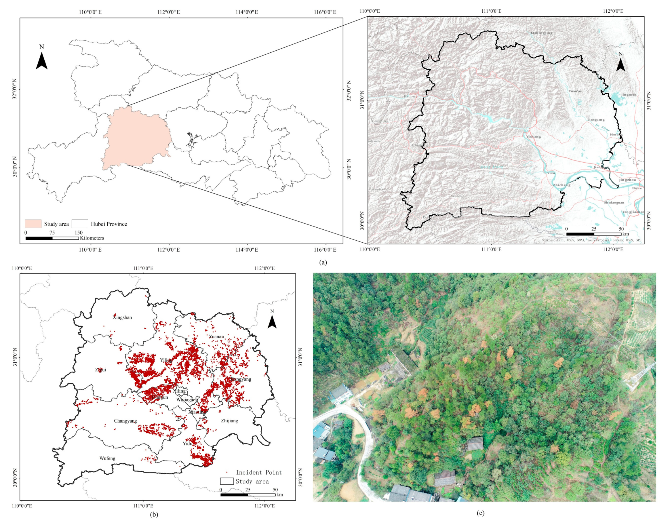
2.1. Study Area
2.2. Data
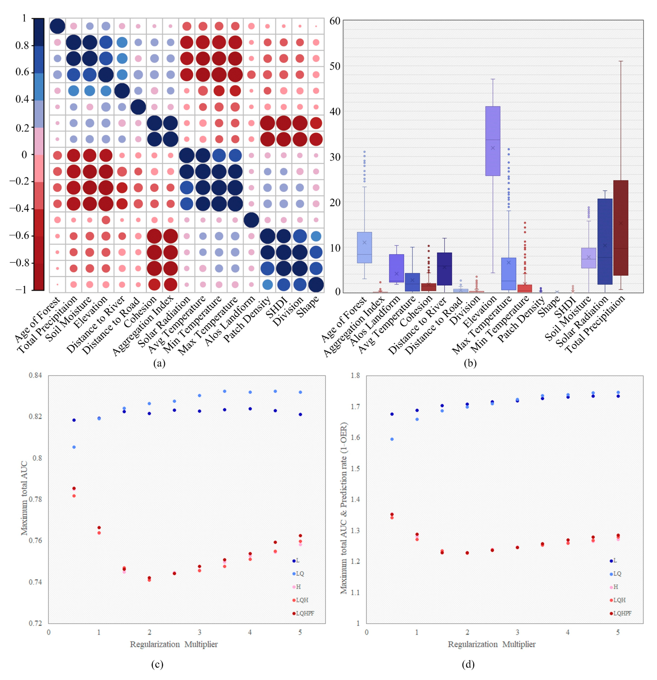
2.3. Maxent Model and Evaluation
2.4. Landscape Metrics
3. Results
3.1. Model Optimization and Evaluation
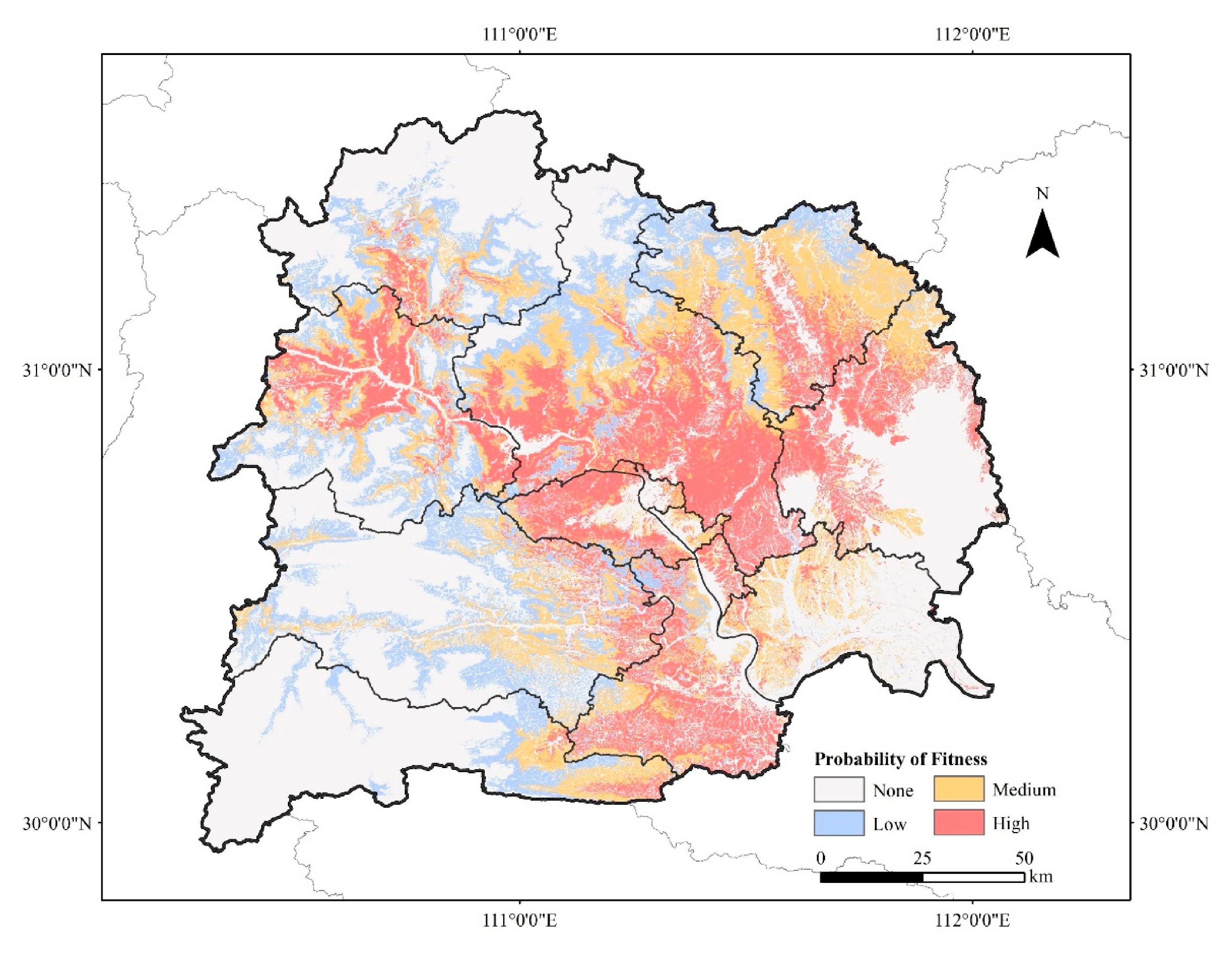
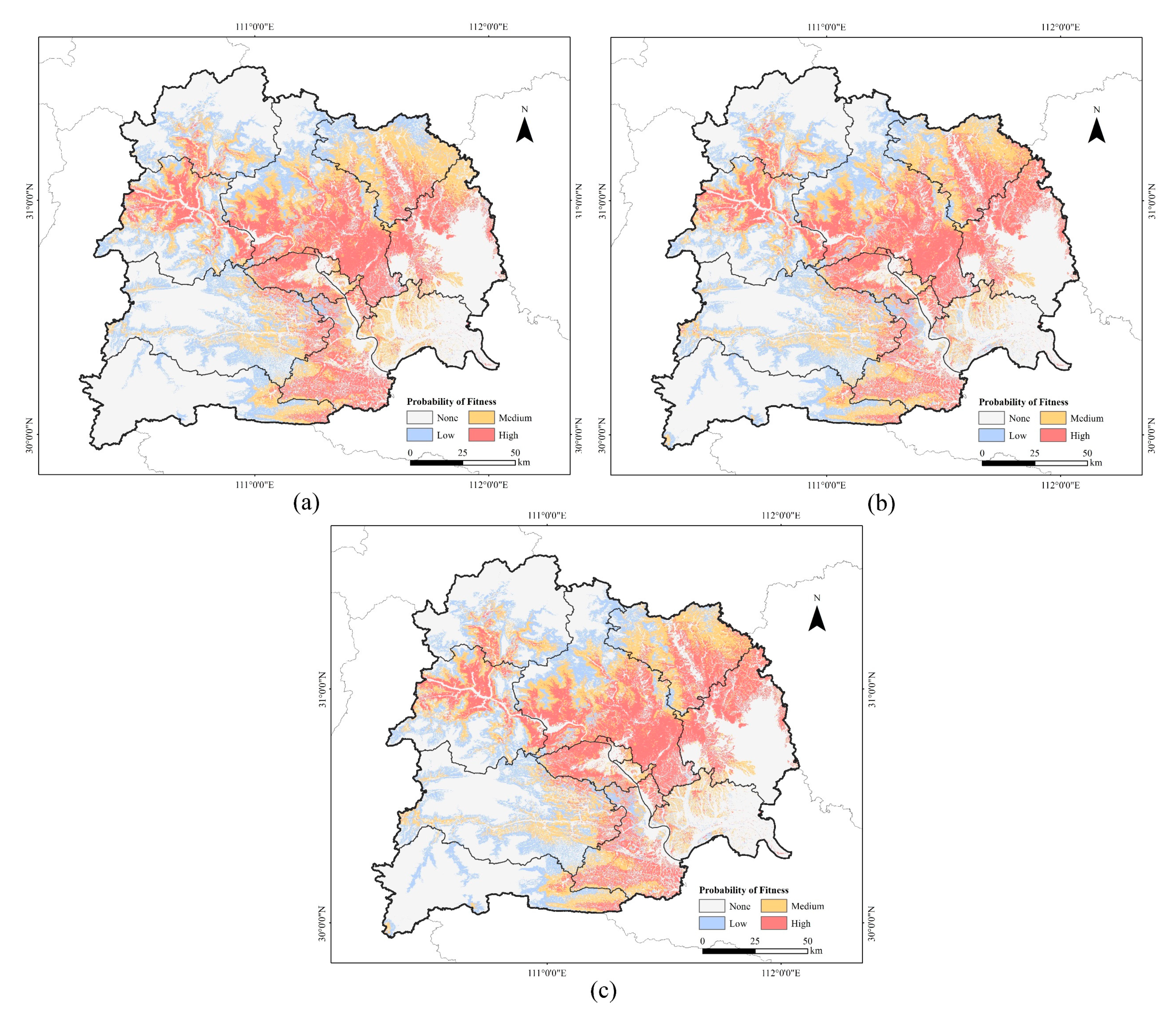
3.2. Suitable Area Analysis
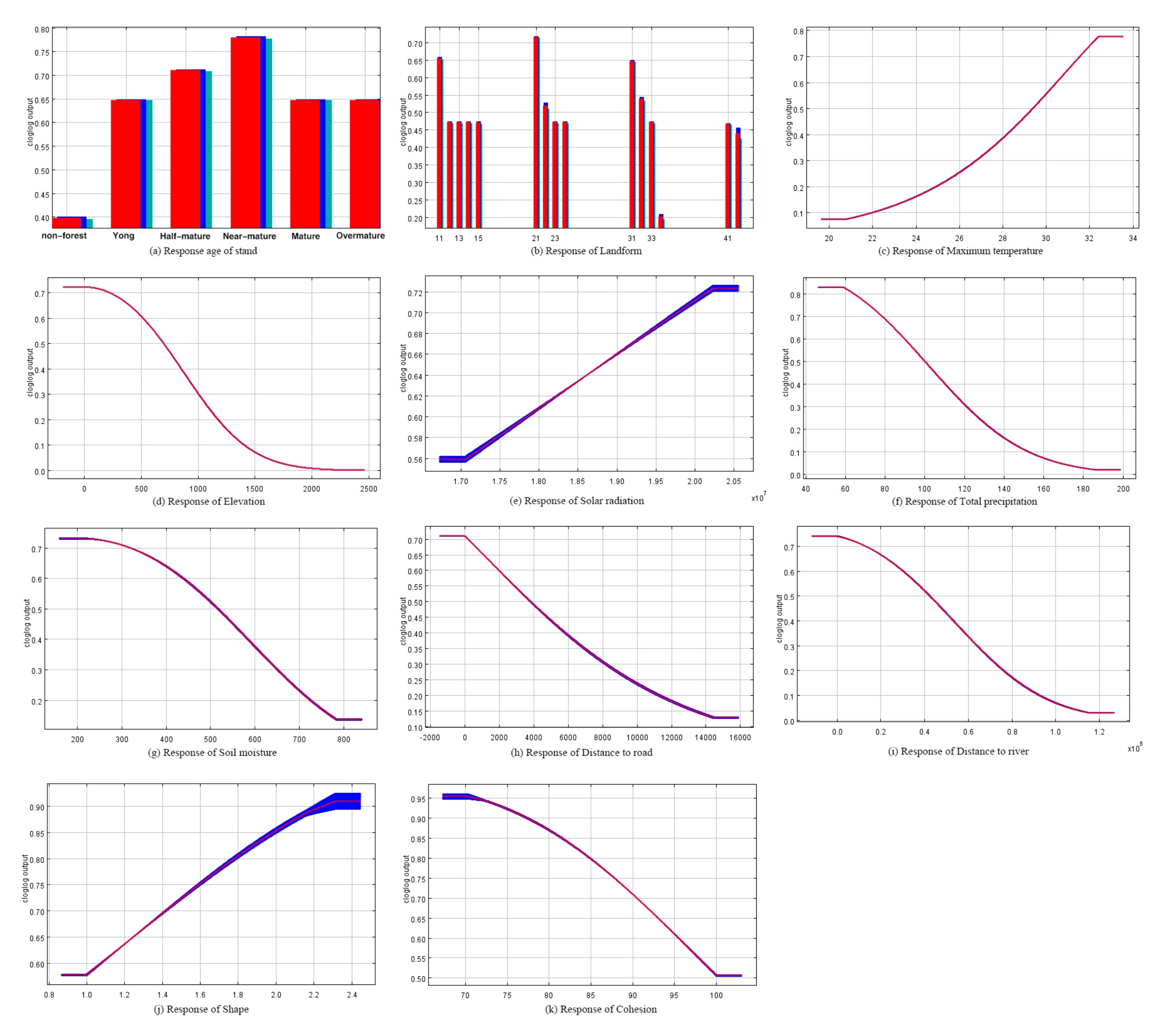
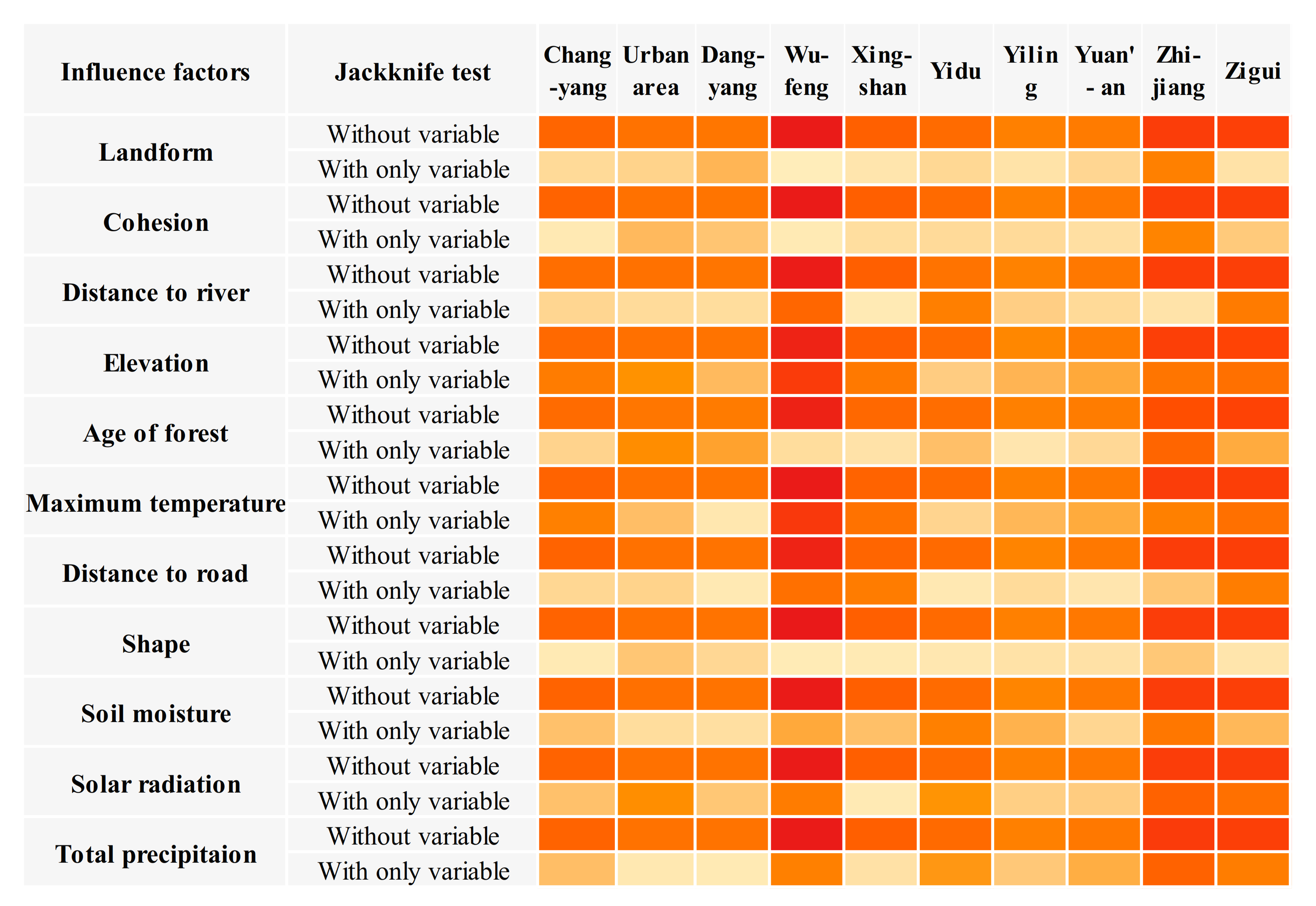
3.3. Group Predictive Analysis of Influence Variables
3.4. Variables of Regional Difference
4. Discussion
5. Conclusions
Author Contributions
Funding
Institutional Review Board Statement
Informed Consent Statement
Data Availability Statement
Conflicts of Interest
References
- Hongyan, Z.; Qinxiao, W.; Guobin, L. Studies on soil and water conservation functions of litter in Chinese pine stand on Loess Plateau. Sci. Silvae Sin. 2003, 39, 168–172. [Google Scholar]
- Tang, X.; Yuan, Y.; Li, X.; Zhang, J. Maximum Entropy Modeling to Predict the Impact of Climate Change on Pine Wilt Disease in China. Front. Plant Sci. 2021, 12, 764. [Google Scholar] [CrossRef] [PubMed]
- Tóth, Á. Bursaphelenchus xylophilus, the pinewood nematode: Its significance and a historical review. Acta Biol. Szeged. 2011, 55, 213–217. [Google Scholar]
- Jung, C.S.; Koh, S.-H.; Nam, Y.; Ahn, J.J.; Lee, C.Y.; Choi, W.I. A Model for Predicting Spring Emergence of Monochamus saltuarius (Coleoptera: Cerambycidae) from Korean white pine, Pinus koraiensis. J. Econ. Èntomol. 2015, 108, 1830–1836. [Google Scholar] [CrossRef]
- An, H.; Lee, S.; Cho, S.J. The Effects of Climate Change on Pine Wilt Disease in South Korea: Challenges and Prospects. Forests 2019, 10, 486. [Google Scholar] [CrossRef] [Green Version]
- Zhao, B.G.; Futai, K.; Sutherland, J.R.; Takeuchi, Y. Pine Wilt Disease; Springer: Berlin/Heidelberg, Germany, 2008. [Google Scholar]
- Ye, J. Epidemic status of pine wilt disease in China and its prevention and control techniques and counter measures. Sci. Silvae Sin. 2019, 55, 1–10. [Google Scholar]
- Zhang, B.; Ye, H.; Lu, W.; Huang, W.; Wu, B.; Hao, Z.; Sun, H. A Spatiotemporal Change Detection Method for Monitoring Pine Wilt Disease in a Complex Landscape Using High-Resolution Remote Sensing Imagery. Remote Sens. 2021, 13, 2083. [Google Scholar] [CrossRef]
- Kim, B.-N.; Kim, J.H.; Ahn, J.-Y.; Kim, S.; Cho, B.-K.; Kim, Y.-H.; Min, J. A short review of the pinewood nematode, Bursaphelenchus xylophilus. Toxicol. Environ. Health Sci. 2020, 12, 297–304. [Google Scholar] [CrossRef]
- Mamiya, Y. History of pine wilt disease in Japan. J. Nematol. 1988, 20, 219–226. [Google Scholar] [PubMed]
- Proença, D.N.; Francisco, R.; Santos, C.V.; Lopes, A.; Fonseca, L.; Abrantes, I.M.; Morais, P.V. Diversity of Bacteria Associated with Bursaphelenchus xylophilus and Other Nematodes Isolated from Pinus pinaster Trees with Pine Wilt Disease. PLoS ONE 2010, 5, e15191. [Google Scholar] [CrossRef] [Green Version]
- Cheng, H.R.; Lin, M.S.; Qian, R.J. A study on morphological diagnosis and pathogenicity of the pine wood nematode. J. Nanjing Agric. Univ. 1986, 2, 55–59. [Google Scholar]
- Zhang, K.; Liang, J.; Yan, D.; Zhang, X. Research advances of pine wood nematode disease in China. World For. Res. 2010, 23, 59–63. [Google Scholar]
- The State Forestry and grassland Administration has taken several measures to control the epidemic situation of pine wood nematode disease. Green China 2019, 3, 16.
- Hao, Z.; Huang, J.; Li, X.; Sun, H.; Fang, G. A multi-point aggregation trend of the outbreak of pine wilt disease in China over the past 20 years. For. Ecol. Manag. 2021, 505, 119890. [Google Scholar] [CrossRef]
- Choi, W.I.; Song, H.J.; Kim, D.S.; Lee, D.-S.; Lee, C.-Y.; Nam, Y.; Kim, J.-B.; Park, Y.-S. Dispersal Patterns of Pine Wilt Disease in the Early Stage of Its Invasion in South Korea. Forests 2017, 8, 411. [Google Scholar] [CrossRef] [Green Version]
- Robinet, C.; Roques, A.; Pan, H.; Fang, G.; Ye, J.; Zhang, Y.; Sun, J. Role of Human-Mediated Dispersal in the Spread of the Pinewood Nematode in China. PLoS ONE 2009, 4, e4646. [Google Scholar] [CrossRef] [PubMed] [Green Version]
- Hirata, A.; Nakamura, K.; Nakao, K.; Kominami, Y.; Tanaka, N.; Ohashi, H.; Takano, K.; Takeuchi, W.; Matsui, T. Potential distribution of pine wilt disease under future climate change scenarios. PLoS ONE 2017, 12, e0182837. [Google Scholar] [CrossRef] [PubMed] [Green Version]
- Rutherford, T.A.; Webster, J.M. Distribution of pine wilt disease with respect to temperature in North America, Japan, and Europe. Can. J. For. Res. 1987, 17, 1050–1059. [Google Scholar] [CrossRef]
- Roques, A.; LiLin, Z.L.Z.; JiangHua, S.J.S.; Robinet, C. Pine wood nematode, pine wilt disease, vector beetle and pine tree: How a multiplayer system could reply to climate change. Clim. Chang. Insect Pests 2015, 220–234. [Google Scholar] [CrossRef]
- Matsuhashi, S.; Hirata, A.; Akiba, M.; Nakamura, K.; Oguro, M.; Takano, K.T.; Nakao, K.; Hijioka, Y.; Matsui, T. Developing a point process model for ecological risk assessment of pine wilt disease at multiple scales. For. Ecol. Manag. 2020, 463, 118010. [Google Scholar] [CrossRef]
- Robinet, C.; Van Opstal, N.; Baker, R.; Roques, A. Applying a spread model to identify the entry points from which the pine wood nematode, the vector of pine wilt disease, would spread most rapidly across Europe. Biol. Invasions 2011, 13, 2981–2995. [Google Scholar] [CrossRef] [Green Version]
- Bai, L.; Tian, C.; Hong, C.; Kang, F.; Chen, J.; Song, D.; Liu, H. The relationship between pine forest landscape patterns and pine wilt disease in Yichang, Hubei Province. Acta Ecol. Sin. 2015, 35, 8107–8116. [Google Scholar]
- Peng, Y.; Pu, Y.; Chen, G. The relationship between forest landscape pattern and injured degree caused by Burasphelenchus xylophilus. J. West China For. Sci. 2016, 45, 19–24. [Google Scholar] [CrossRef] [Green Version]
- Hong, C.; Zhang, Z.; Cai, S.; Chen, J.; Song, D.; Li, Y. Analysis and risk prediction of pinewood nematodes based on landscape patterns: A case study from Yichang, China. Chin. J. Ecol. 2018, 37, 3371–3380. [Google Scholar]
- Han, Y.; Wang, Y.; Xiang, Y.; Ye, J. Prediction of potential distribution of Bursaphelenchus xylophilus in China based on Maxent ecological niche model. J. Nanjing For. Univ. (Nat. Sci. Ed.) 2015, 39, 6–10. [Google Scholar]
- Lee, D.-S.; Choi, W.I.; Nam, Y.; Park, Y.-S. Predicting potential occurrence of pine wilt disease based on environmental factors in South Korea using machine learning algorithms. Ecol. Inform. 2021, 64, 101378. [Google Scholar] [CrossRef]
- Xiao, D.; Li, J. Analysis on the causes and Control benefits of Pine Wood nematode Disease in Yichang City. Hubei For. Sci. Technol. 2017, 46, 59–61. [Google Scholar]
- Phillips, S.J.; Dudík, M.; Schapire, R.E. A Maximum Entropy Approach to Species Distribution Modeling. In Proceedings of the Twenty-First International Conference on Machine Learning, Banff, AB, Canada, 4–8 July 2004; pp. 655–662. [Google Scholar] [CrossRef] [Green Version]
- Bai, L. Study on the Relationship between Landscape Patterns and the Spread of Pine Wilt Disease in Yichang, Hubei Province; Beijing Forestry University: Beijing, China, 2015. [Google Scholar]
- Fukuda, K. Physiological Process of the Symptom Development and Resistance Mechanism in Pine Wilt Disease. J. For. Res. 1997, 2, 171–181. [Google Scholar] [CrossRef]
- Dozono, Y.; Yoshida, N. Application of the logistic curve for the population growth of pine wood nematode, Busaphelenchus lignicolus, on the cultures of Botrytis cinerea. J. Jpn. For. Soc. 1974, 56, 146–148. [Google Scholar]
- Sousa, E.; Rodrigues, J.M.; Bonifácio, L.F.; Naves, P.M.; Rodrigues, A. Management and Control of the Pine Wood Nematode, Bursaphelenchus xylophilus, in Portugal. In Nematodes: Morphology, Functions and Management Strategies; Nova Science Publishers, Inc.: Hauppauge, NY, USA, 2011; pp. 157–178. [Google Scholar]
- Naoe, S.; Ikeda, T. Hazard Map for Pine Wilt Disease in Kyoto City. J. Jpn. For. Soc. 2011, 93, 33–36. [Google Scholar] [CrossRef]
- Gao, R. Effect of Bursaphelenchus xylophilus Invasion on Masson Pine Forest Ecosystem in the Three Gorges Reservoir Region, China; Beijing Forestry University: Beijing, China, 2017. [Google Scholar]
- Hirzel, A.H.; Le Lay, G. Habitat suitability modelling and niche theory. J. Appl. Ecol. 2008, 45, 1372–1381. [Google Scholar] [CrossRef]
- Wan, J.-Z.; Yu, J.-H.; Yin, G.-J.; Song, Z.-M.; Wei, D.-X.; Wang, C.-J. Effects of soil properties on the spatial distribution of forest vegetation across China. Glob. Ecol. Conserv. 2019, 18, e00635. [Google Scholar] [CrossRef]
- Tiao, N.; Yuling, F.; Jian, T. Advances in research on Bursaphelenchus xyophilus and its key vector Monochamus spp. Kun Chong zhi shi = Kunchong Zhishi 2004, 41, 97–104. [Google Scholar]
- Mota, M.M.; Futai, K.; Vieira, P. Pine Wilt Disease and the Pinewood Nematode, Bursaphelenchus xylophilus; Springer: Dordrecht, The Netherlands, 2009. [Google Scholar]
- Jimenezvalverde, A.; Peterson, A.T.; Soberon, J.; Overton, J.M.; Aragón, P.; Lobo, J.M. Use of niche models in invasive species risk assessments. Biol. Invasions 2011, 13, 2785–2797. [Google Scholar] [CrossRef]
- Li, Y.; Li, M.; Li, C.; Liu, Z. Optimized Maxent Model Predictions of Climate Change Impacts on the Suitable Distribution of Cunninghamia lanceolata in China. Forests 2020, 11, 302. [Google Scholar] [CrossRef] [Green Version]
- Warren, D.L.; Seifert, S.N. Ecological niche modeling in Maxent: The importance of model complexity and the performance of model selection criteria. Ecol. Appl. 2011, 21, 335–342. [Google Scholar] [CrossRef] [Green Version]

| Raster Dataset | ||
| Variable | Spatial Resolution | Unit |
| Average Temperature of July | 0.1 arc degrees | °C |
| Solar Radiation of June | 0.1 arc degrees | J/m2 |
| Total Precipitation of July | 2.5 arc minutes | mm |
| Soil Moisture of July | 2.5 arc minutes | mm |
| Maximum Temperature of July | 2.5 arc minutes | °C |
| Minimum Temperature of July | 2.5 arc minutes | °C |
| Elevation | 30 m | m |
| Landform | 90 m | Class |
| Age of Stand | 30 m | Class |
| AI | 30 m | % (0, 100] |
| Cohesion | 30 m | % (0, 100] |
| Division | 30 m | PR ≥ 1 |
| PD | 30 m | n/100 ha |
| SHDI | 30 m | none |
| Shape | 30 m | none |
| Vector Calculation Result Data | ||
| Variable | Vector Dataset | Unit |
| Distance to Road | Road network shapefile | m |
| Distance to Water | Yangtze River shapefile | m |
Publisher’s Note: MDPI stays neutral with regard to jurisdictional claims in published maps and institutional affiliations. |
© 2022 by the authors. Licensee MDPI, Basel, Switzerland. This article is an open access article distributed under the terms and conditions of the Creative Commons Attribution (CC BY) license (https://creativecommons.org/licenses/by/4.0/).
Share and Cite
Hao, Z.; Fang, G.; Huang, W.; Ye, H.; Zhang, B.; Li, X. Risk Prediction and Variable Analysis of Pine Wilt Disease by a Maximum Entropy Model. Forests 2022, 13, 342. https://doi.org/10.3390/f13020342
Hao Z, Fang G, Huang W, Ye H, Zhang B, Li X. Risk Prediction and Variable Analysis of Pine Wilt Disease by a Maximum Entropy Model. Forests. 2022; 13(2):342. https://doi.org/10.3390/f13020342
Chicago/Turabian StyleHao, Zhuoqing, Guofei Fang, Wenjiang Huang, Huichun Ye, Biyao Zhang, and Xiaodong Li. 2022. "Risk Prediction and Variable Analysis of Pine Wilt Disease by a Maximum Entropy Model" Forests 13, no. 2: 342. https://doi.org/10.3390/f13020342
APA StyleHao, Z., Fang, G., Huang, W., Ye, H., Zhang, B., & Li, X. (2022). Risk Prediction and Variable Analysis of Pine Wilt Disease by a Maximum Entropy Model. Forests, 13(2), 342. https://doi.org/10.3390/f13020342