
Improving the Accuracy of Estimating Forest Carbon Density Using the Tree Species Classification Method

Abstract
1. Introduction
2. Materials and Methods
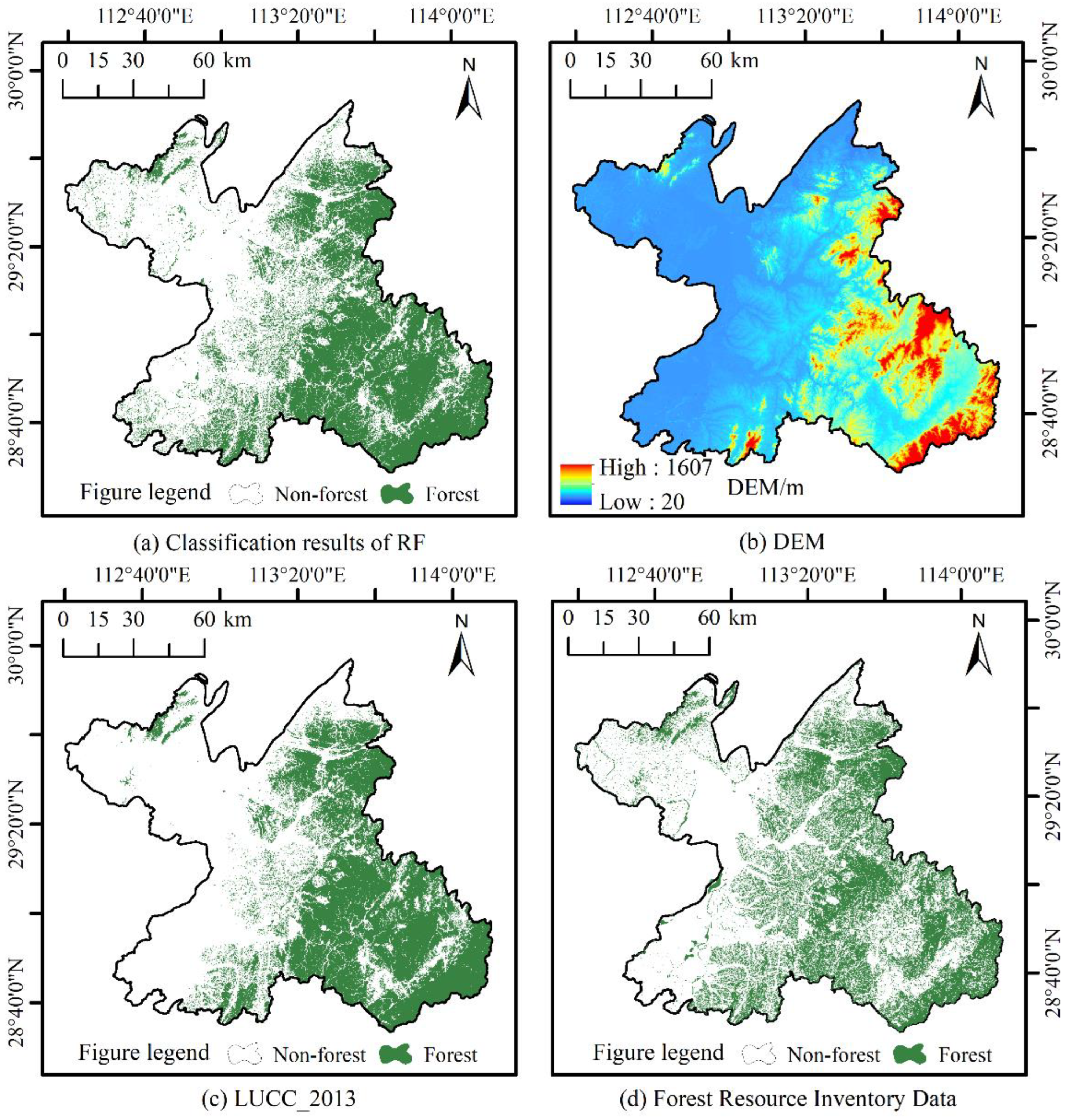
2.1. Study Area
2.2. Data Acquisition and Preprocessing
2.3. Research Method
2.3.1. Classification of Dominant Tree Species Based on the GEE Platform
2.3.2. Estimation of Forest Carbon Storage
2.3.3. Selection of Modeling Factors
2.3.4. Selection of Sample Data
2.3.5. Carbon Density Inversion Model Construction
2.3.6. Accuracy Evaluation
3. Results
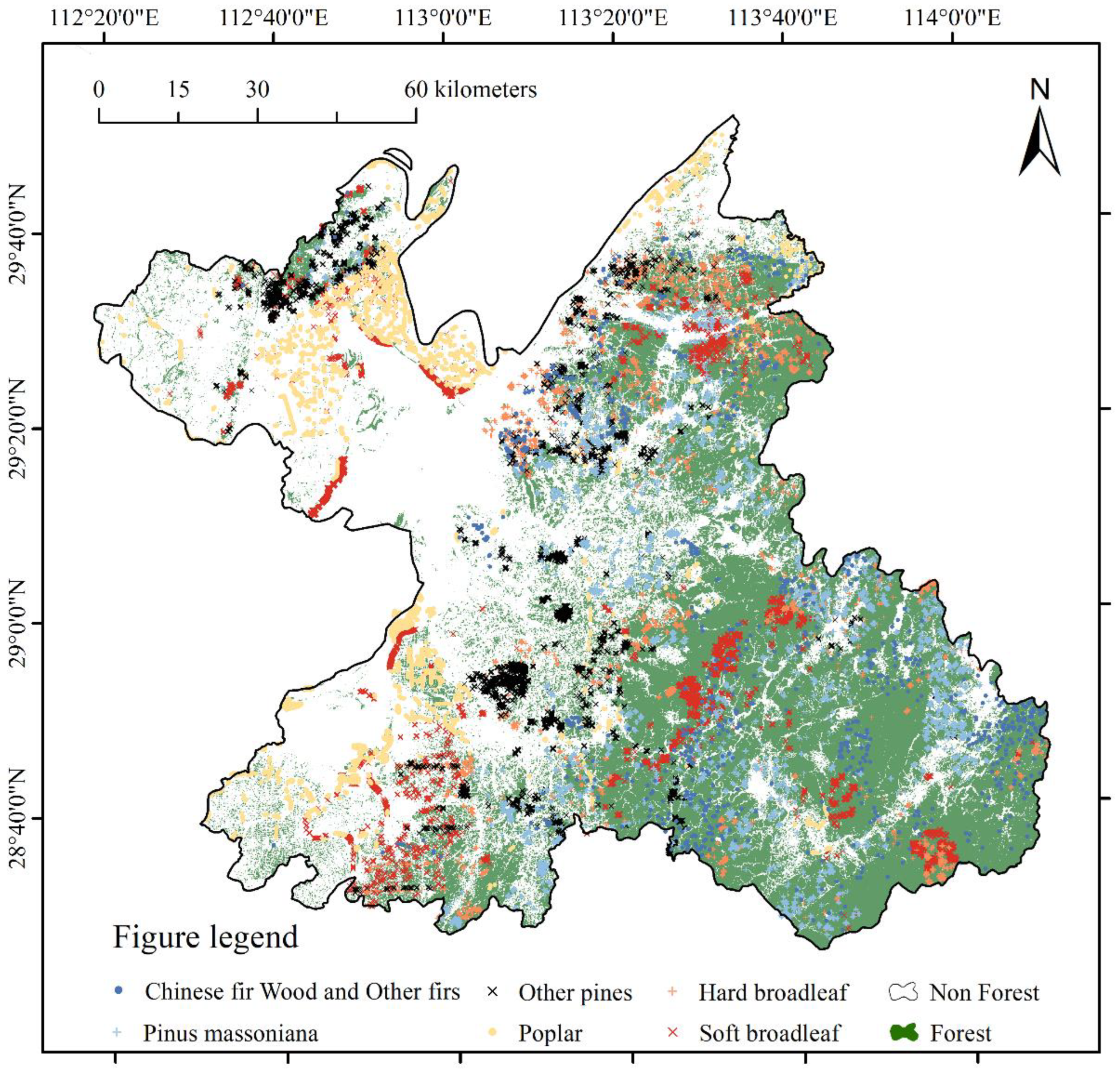
3.1. Classification Results for Dominant Species
3.2. Sample Data Filtering
3.3. Model Estimation Results and Accuracy Evaluation
3.4. Forest Carbon Density Inversion Mapping
4. Discussion
5. Conclusions
Author Contributions
Funding
Data Availability Statement
Conflicts of Interest
References
- Mikhaylov, A.; Moiseev, N.; Aleshin, K.; Burkhardt, T. Global climate change and greenhouse effect. Entrep. Sustain. Issues 2020, 7, 2897–2913. [Google Scholar] [CrossRef]
- Liu, X.; Trogisch, S.; He, J.S.; Niklaus, P.A.; Bruelheide, H.; Tang, Z.; Erfmeier, A.; Scherer-Lorenzen, M.; Pietsch, K.A.; Yang, B.; et al. Tree species richness increases ecosystem carbon storage in subtropical forests. Proc. R. Soc. B 2018, 285, 20181240. [Google Scholar] [CrossRef] [PubMed]
- Huang, L.; Zhou, M.; Lv, J.; Chen, K. Trends in global research in forest carbon sequestration: A bibliometric analysis. J. Clean. Prod. 2019, 252, 119908. [Google Scholar] [CrossRef]
- Raihan, A.; Begum, R.A.; Said, M.N.M.; Pereira, J.J. Assessment of Carbon Stock in Forest Biomass and Emission Reduction Potential in Malaysia. Forests 2021, 12, 1294. [Google Scholar] [CrossRef]
- Yin, S.; Gong, Z.; Gu, L.; Deng, Y.; Niu, Y. Driving forces of the efficiency of forest carbon sequestration production: Spatial panel data from the national forest inventory in China. J. Clean. Prod. 2021, 330, 129776. [Google Scholar] [CrossRef]
- Felipe-Lucia, M.R.; Soliveres, S.; Penone, C.; Manning, P.; van der Plas, F.; Boch, S.; Prati, D.; Ammer, C.; Schall, P.; Gossner, M.M.; et al. Multiple forest attributes underpin the supply of multiple ecosystem services. Nat. Commun. 2018, 9, 4839. [Google Scholar] [CrossRef] [PubMed]
- Ouyang, S.; Xiang, W.; Wang, X.; Xiao, W.; Chen, L.; Li, S.; Sun, H.; Deng, X.; Forrester, D.I.; Zeng, L.; et al. Effects of stand age, richness and density on productivity in subtropical forests in China. J. Ecol. 2019, 107, 2266–2277. [Google Scholar] [CrossRef]
- Omer, G.; Mutanga, O.; Abdel-Rahman, E.M.; Adam, E. Performance of Support Vector Machines and Artificial Neural Network for Mapping Endangered Tree Species Using WorldView-2 Data in Dukuduku Forest, South Africa. IEEE J. Sel. Top. Appl. Earth Obs. Remote Sens. 2015, 8, 4825–4840. [Google Scholar] [CrossRef]
- Meng, Y.; Cao, B.; Mao, P.; Dong, C.; Cao, X.; Qi, L.; Wang, M.; Wu, Y. Tree Species Distribution Change Study in Mount Tai Based on Landsat Remote Sensing Image Data. Forests 2020, 11, 130. [Google Scholar] [CrossRef]
- Basheer, S.; Wang, X.; Farooque, A.A.; Nawaz, R.A.; Liu, K.; Adekanmbi, T.; Liu, S. Comparison of Land Use Land Cover Classifiers Using Different Satellite Imagery and Machine Learning Techniques. Remote Sens. 2022, 14, 4978. [Google Scholar] [CrossRef]
- Poorazimy, M.; Shataee, S.; McRoberts, R.E.; Mohammadi, J. Integrating airborne laser scanning data, space-borne radar data and digital aerial imagery to estimate aboveground carbon stock in Hyrcanian forests, Iran. Remote Sens. Environ. 2020, 240, 111669. [Google Scholar] [CrossRef]
- Gomes, L.C.; Faria, R.M.; de Souza, E.; Veloso, G.V.; Schaefer, C.E.G.; Fernandes Filho, E.I. Modelling and mapping soil organic carbon stocks in Brazil. Geoderma 2019, 340, 337–350. [Google Scholar] [CrossRef]
- Khan, D.; Muneer, M.A.; Nisa, Z.U.; Shah, S.; Amir, M.; Saeed, S.; Uddin, S.; Munir, M.Z.; Gao, L.; Huang, H. Effect of climatic factors on stem biomass and carbon stock of Larix gmelinii and Betula platyphylla in Daxing’anling Mountain of Inner Mongolia, China. Adv. Meteorol. 2019, 10, 5692574. [Google Scholar] [CrossRef]
- Pham, T.D.; Yokoya, N.; Bui, D.T.; Yoshino, K.; Friess, D.A. Remote Sensing Approaches for Monitoring Mangrove Species, Structure, and Biomass: Opportunities and Challenges. Remote Sens. 2019, 11, 230. [Google Scholar] [CrossRef]
- Byrd, K.B.; Ballanti, L.; Thomas, N.; Nguyen, D.; Holmquist, J.R.; Simard, M.; Windham-Myers, L. A remote sensing-based model of tidal marsh aboveground carbon stocks for the conterminous United States. Isprs. J. Photogramm 2018, 139, 255–271. [Google Scholar] [CrossRef]
- Su, Y.; Guo, Q.; Xue, B.; Hu, T.; Alvarez, O.; Tao, S.; Fang, J. Spatial distribution of forest aboveground biomass in China: Estimation through combination of spaceborne lidar, optical imagery, and forest inventory data. Remote Sens. Environ. 2016, 173, 187–199. [Google Scholar] [CrossRef]
- Rodríguez-Veiga, P.; Wheeler, J.; Louis, V.; Tansey, K.; Balzter, H. Quantifying Forest Biomass Carbon Stocks From Space. Curr. For. Rep. 2017, 3, 1–18. [Google Scholar] [CrossRef]
- Vicharnakorn, P.; Shrestha, R.P.; Nagai, M.; Salam, A.P.; Kiratiprayoon, S. Carbon Stock Assessment Using Remote Sensing and Forest Inventory Data in Savannakhet, Lao PDR. Remote Sens. 2014, 6, 5452–5479. [Google Scholar] [CrossRef]
- Yan, E.; Lin, H.; Wang, G.; Sun, H. Improvement of Forest Carbon Estimation by Integration of Regression Modeling and Spectral Unmixing of Landsat Data. IEEE Geosci. Remote Sens. Lett. 2015, 12, 2003–2007. [Google Scholar] [CrossRef]
- Zhang, J.; Lu, C.; Xu, H. Estimating aboveground biomass of Pinus densata-dominated forests using Landsat time series and permanent sample plot data. J. For. Res. 2019, 30, 1689–1706. [Google Scholar] [CrossRef]
- Fassnacht, F.E.; Hartig, F.; Latifi, H.; Berger, C.; Hernández, J.; Corvalán, P.; Koch, B. Importance of sample size, data type and prediction method for remote sensing-based estimations of aboveground forest biomass. Remote Sens Environ. 2014, 154, 102–114. [Google Scholar] [CrossRef]
- Lu, D.; Chen, Q.; Wang, G.; Liu, L.; Li, G.; Moran, E. A survey of remote sensing-based aboveground biomass estimation methods in forest ecosystems. Int. J. Digit. Earth 2014, 9, 63–105. [Google Scholar] [CrossRef]
- Huang, W.; Li, W.; Xu, J.; Ma, X.; Li, C.; Liu, C. Hyperspectral Monitoring Driven by Machine Learning Methods for Grassland Above-Ground Biomass. Remote Sens. 2022, 14, 2086. [Google Scholar] [CrossRef]
- Sekertekin, A.; Abdikan, S.; Marangoz, A.M. The acquisition of impervious surface area from LANDSAT 8 satellite sensor data using urban indices: A comparative analysis. Environ. Monit. Assess. 2018, 190, 381. [Google Scholar] [CrossRef] [PubMed]
- Van der Werff, H.; Van der Meer, F. Sentinel-2A MSI and Landsat 8 OLI Provide Data Continuity for Geological Remote Sensing. Remote Sens. 2016, 8, 883. [Google Scholar] [CrossRef]
- Mandanici, E.; Bitelli, G. Preliminary Comparison of Sentinel-2 and Landsat 8 Imagery for a Combined Use. Remote Sens. 2016, 8, 1014. [Google Scholar] [CrossRef]
- Phiri, D.; Morgenroth, J.; Xu, C.; Hermosilla, T. Effects of pre-processing methods on Landsat OLI-8 land cover classification using OBIA and random forests classifier. Int. J. Appl. Earth Obs. Geoinf. ITC J. 2018, 73, 170–178. [Google Scholar] [CrossRef]
- Ward, A.; Dargusch, P.; Thomas, S.; Liu, Y.; Fulton, E.A. A global estimate of carbon stored in the world’s mountain grasslands and shrublands, and the implications for climate policy. Glob. Environ. Chang. 2014, 28, 14–24. [Google Scholar] [CrossRef]
- Yang, J.; Huang, X. The 30 m annual land cover dataset and its dynamics in China from 1990 to 2019. Earth Syst. Sci. Data 2021, 13, 3907–3925. [Google Scholar] [CrossRef]
- Li, H.; Zhao, P.; Lei, Y.; Zeng, W. Comparison on Estimation of Wood Biomass Using Forest Inventory Data. Chin. For. Sci. Technol. 2012, 48, 44–52. [Google Scholar]
- IPCC. IPCC Guidelines for National Greenhouse Gas Inventories: Agriculture, Forestry and Other Land Use; Institute of Global Environment Strategies: Tokyo, Japan, 2006.
- The State Forestry Administration of the People’s Republic of China. Guidelines on Carbon Accounting and Monitoring for Afforestation Project; Standards Press of China: Beijing, China, 2014; pp. 30–33.
- Randin, C.F.; Ashcroft, M.B.; Bolliger, J.; Cavender-Bares, J.; Coops, N.C.; Dullinger, S.; Dirnböck, T.; Eckert, S.; Ellis, E.; Fernández, N.; et al. Monitoring biodiversity in the Anthropocene using remote sensing in species distribution models. Remote Sens. Environ. 2020, 239, 111626. [Google Scholar] [CrossRef]
- Zhao, Y.; Potgieter, A.B.; Zhang, M.; Wu, B.; Hammer, G.L. Predicting Wheat Yield at the Field Scale by Combining High-Resolution Sentinel-2 Satellite Imagery and Crop Modelling. Remote Sens. 2020, 12, 1024. [Google Scholar] [CrossRef]
- Otgonbayar, M.; Atzberger, C.; Chambers, J.; Damdinsuren, A. Mapping pasture biomass in Mongolia using Partial Least Squares, Random Forest regression and Landsat 8 imagery. Int. J. Remote Sens. 2018, 40, 3204–3226. [Google Scholar] [CrossRef]
- Li, C.; Li, Y.; Li, M. Improving Forest Aboveground Biomass (AGB) Estimation by Incorporating Crown Density and Using Landsat 8 OLI Images of a Subtropical Forest in Western Hunan in Central China. Forests 2019, 10, 104. [Google Scholar] [CrossRef]
- Yang, B.; Zhang, Y.; Mao, X.; Lv, Y.; Shi, F.; Li, M. Mapping Spatiotemporal Changes in Forest Type and Aboveground Biomass from Landsat Long-Term Time-Series Analysis—A Case Study from Yaoluoping National Nature Reserve, Anhui Province of Eastern China. Remote Sens. 2022, 14, 2786. [Google Scholar] [CrossRef]
- Lumbierres, M.; Méndez, P.F.; Bustamante, J.; Soriguer, R.; Santamaría, L. Modeling Biomass Production in Seasonal Wetlands Using MODIS NDVI Land Surface Phenology. Remote Sens. 2017, 9, 392. [Google Scholar] [CrossRef]
- Coltri, P.P.; Zullo, J.; do Valle Goncalves, R.R.; Romani, L.A.S.; Pinto, H.S. Coffee crop’s biomass and carbon stock estimation with usage of high resolution satellites images. IEEE J.-STARS 2013, 6, 1786–1795. [Google Scholar]
- Pandey, P.C.; Anand, A.; Srivastava, P.K. Spatial distribution of mangrove forest species and biomass assessment using field inventory and earth observation hyperspectral data. Biodivers Conserv. 2019, 28, 2143–2162. [Google Scholar] [CrossRef]
- Gao, L.; Chai, G.; Zhang, X. Above-Ground Biomass Estimation of Plantation with Different Tree Species Using Airborne LiDAR and Hyperspectral Data. Remote Sens. 2022, 14, 2568. [Google Scholar] [CrossRef]


| Tree Species and Group | BEF | RSR | WD | CF |
|---|---|---|---|---|
| Chinese fir wood and other firs | 1.634 | 0.246 | 0.307 | 0.520 |
| Pinus massoniana | 1.472 | 0.187 | 0.380 | 0.460 |
| Other pines | 1.631 | 0.206 | 0.424 | 0.511 |
| Poplar | 1.446 | 0.227 | 0.378 | 0.496 |
| Hard broadleaf | 1.674 | 0.261 | 0.598 | 0.497 |
| Soft broadleaf | 1.586 | 0.289 | 0.443 | 0.485 |
| Vegetation Factor | Formula |
|---|---|
| NDVI | |
| RVI | |
| EVI | |
| DVI | |
| GRVI |
| Category | UA (Pixels/%) | PA (Pixels/%) | OA (Pixels/%) | Kappa |
|---|---|---|---|---|
| Forest | 92.86 | 86.67 | 93.79 | 0.9145 |
| Water | 96.88 | 96.87 | ||
| Building lands | 92.68 | 100 | ||
| other lands | 93.33 | 91.80 |
| Method | Category | UA (Pixels/%) | PA (Pixels/%) | OA (Pixels/%) | Kappa |
|---|---|---|---|---|---|
| RF | Chinese fir wood and other firs | 78.57 | 50.00 | 87.30 | 0.7747 |
| Pinus massoniana | 70.69 | 85.42 | |||
| Other pines | 72.09 | 62.00 | |||
| Poplar | 97.62 | 97.62 | |||
| Hard broadleaf | 68.08 | 68.09 | |||
| Soft broadleaf | 92.84 | 95.92 | |||
| SVM | Chinese fir wood and other firs | 55.29 | 61.84 | 66.74 | 0.6006 |
| Pinus massoniana | 63.37 | 75.29 | |||
| Other pines | 70.33 | 68.09 | |||
| Poplar | 92.31 | 100 | |||
| Hard broadleaf | 57.53 | 65.63 | |||
| Soft broadleaf | 60.38 | 35.56 |
| Tree Species and Group | Number (Piece) | Min (m3·hm−2) | Max (m3·hm−2) | Average (m3·hm−2) | Standard Deviation (m3·hm−2) |
|---|---|---|---|---|---|
| Chinese fir wood and other firs | 1000 | 6.04 | 99.11 | 34.21 | 22.75 |
| Pinus massoniana | 1000 | 6.92 | 61.67 | 31.48 | 13.72 |
| Other pines | 1000 | 6.00 | 85.11 | 40.40 | 21.86 |
| Poplar | 1000 | 12.22 | 93.33 | 47.75 | 15.59 |
| Hard broadleaf | 1000 | 8.97 | 70.41 | 37.25 | 17.29 |
| Soft broadleaf | 1000 | 3.97 | 87.14 | 32.32 | 19.83 |
| Total | 6000 | 3.97 | 99.11 | - | - |
| Model | Tree Species and Group | R2 | RMSE (t·hm−2) | MAE (t·hm−2) |
|---|---|---|---|---|
| MLR | Chinese fir wood and other firs | 0.312 | 6.1289 | 4.9009 |
| Pinus massoniana | 0.199 | 3.8054 | 3.1529 | |
| Other pines | 0.286 | 7.8201 | 6.4654 | |
| Poplar | 0.090 | 4.5832 | 3.9105 | |
| Hard broadleaf | 0.407 | 8.3541 | 6.8165 | |
| Soft broadleaf | 0.386 | 5.0962 | 4.0865 | |
| SVM | Chinese fir wood and other firs | 0.342 | 6.6304 | 5.3309 |
| Pinus massoniana | 0.249 | 5.3851 | 4.5164 | |
| Other pines | 0.294 | 7.7728 | 6.3876 | |
| Poplar | 0.165 | 4.3904 | 3.7138 | |
| Hard broadleaf | 0.445 | 8.0824 | 6.5731 | |
| Soft broadleaf | 0.431 | 4.8909 | 3.9716 | |
| RF | Chinese fir wood and other firs | 0.5346 | 4.2854 | 3.6629 |
| Pinus massoniana | 0.5363 | 2.2501 | 1.9841 | |
| Other pines | 0.6220 | 4.8738 | 4.1110 | |
| Poplar | 0.4054 | 3.1805 | 2.7538 | |
| Hard broadleaf | 0.7672 | 4.4380 | 3.7781 | |
| Soft broadleaf | 0.6534 | 2.9607 | 2.5848 |
Publisher’s Note: MDPI stays neutral with regard to jurisdictional claims in published maps and institutional affiliations. |
© 2022 by the authors. Licensee MDPI, Basel, Switzerland. This article is an open access article distributed under the terms and conditions of the Creative Commons Attribution (CC BY) license (https://creativecommons.org/licenses/by/4.0/).
Share and Cite
Pang, Z.; Zhang, G.; Tan, S.; Yang, Z.; Wu, X. Improving the Accuracy of Estimating Forest Carbon Density Using the Tree Species Classification Method. Forests 2022, 13, 2004. https://doi.org/10.3390/f13122004
Pang Z, Zhang G, Tan S, Yang Z, Wu X. Improving the Accuracy of Estimating Forest Carbon Density Using the Tree Species Classification Method. Forests. 2022; 13(12):2004. https://doi.org/10.3390/f13122004
Chicago/Turabian StylePang, Ziheng, Gui Zhang, Sanqing Tan, Zhigao Yang, and Xin Wu. 2022. "Improving the Accuracy of Estimating Forest Carbon Density Using the Tree Species Classification Method" Forests 13, no. 12: 2004. https://doi.org/10.3390/f13122004
APA StylePang, Z., Zhang, G., Tan, S., Yang, Z., & Wu, X. (2022). Improving the Accuracy of Estimating Forest Carbon Density Using the Tree Species Classification Method. Forests, 13(12), 2004. https://doi.org/10.3390/f13122004