
Forest Transformation in the Wake of Colonization: The Quijos Andean Amazonian Flank, Past and Present


Abstract
:1. Introduction
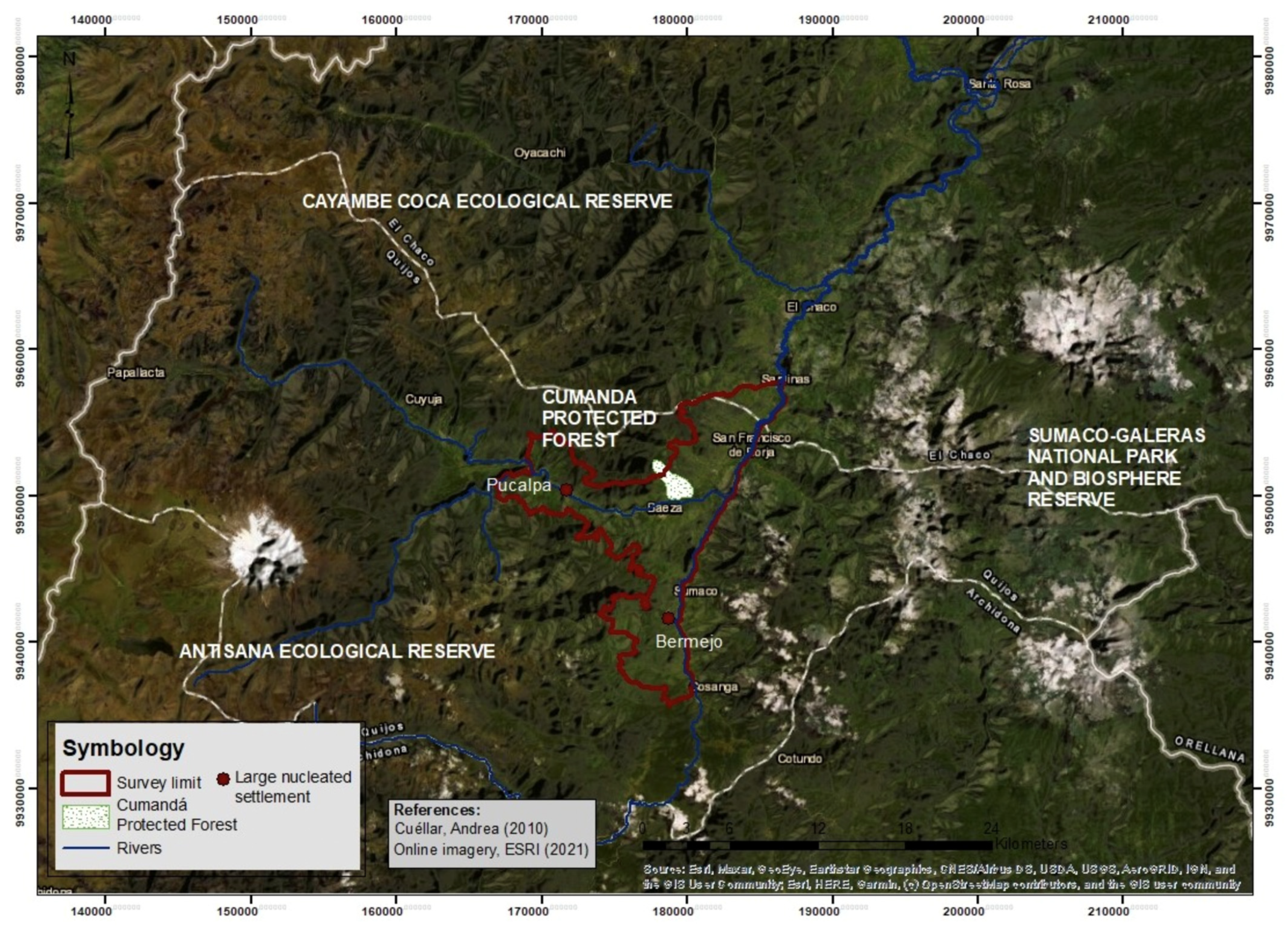
The Study Area
2. Materials and Methods
3. Results
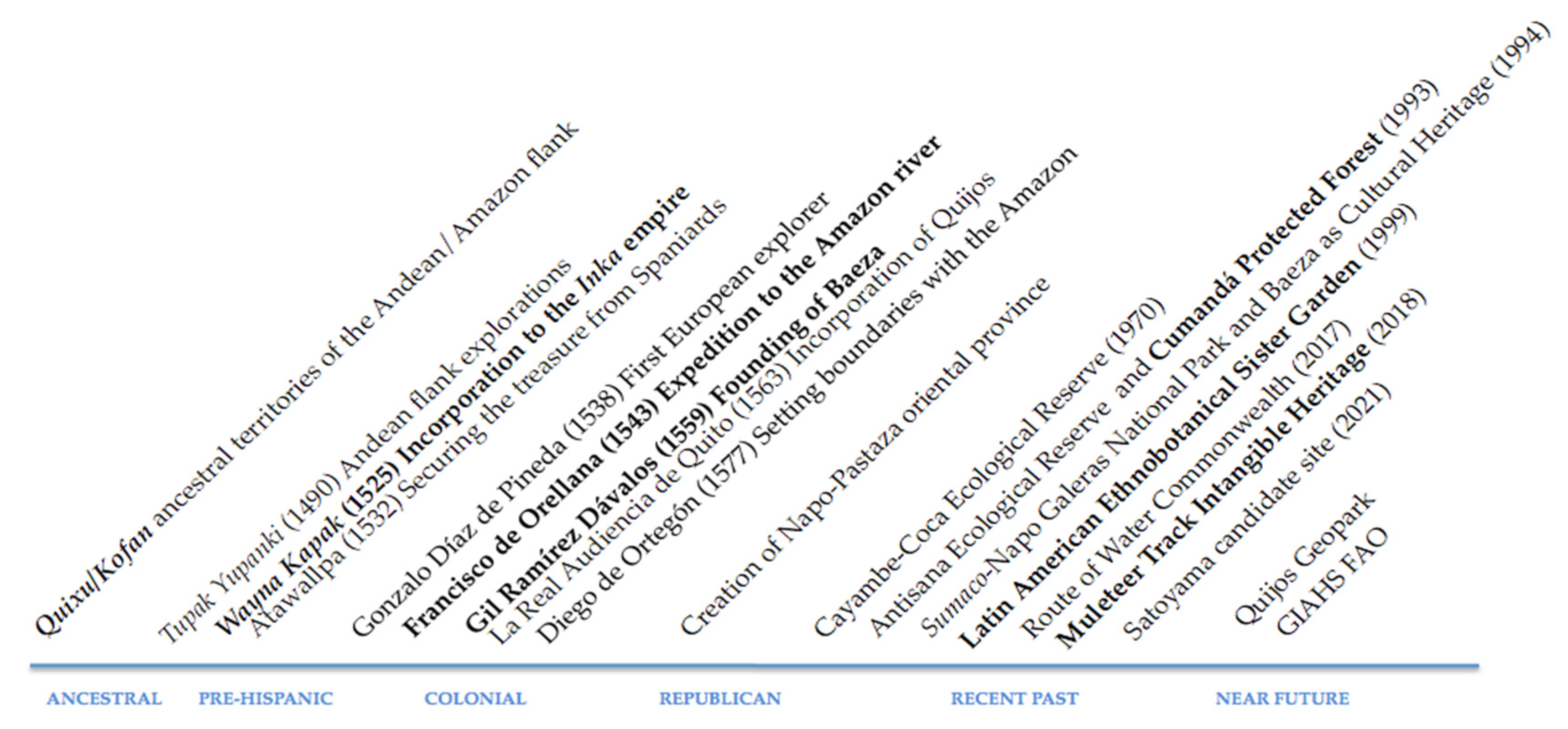
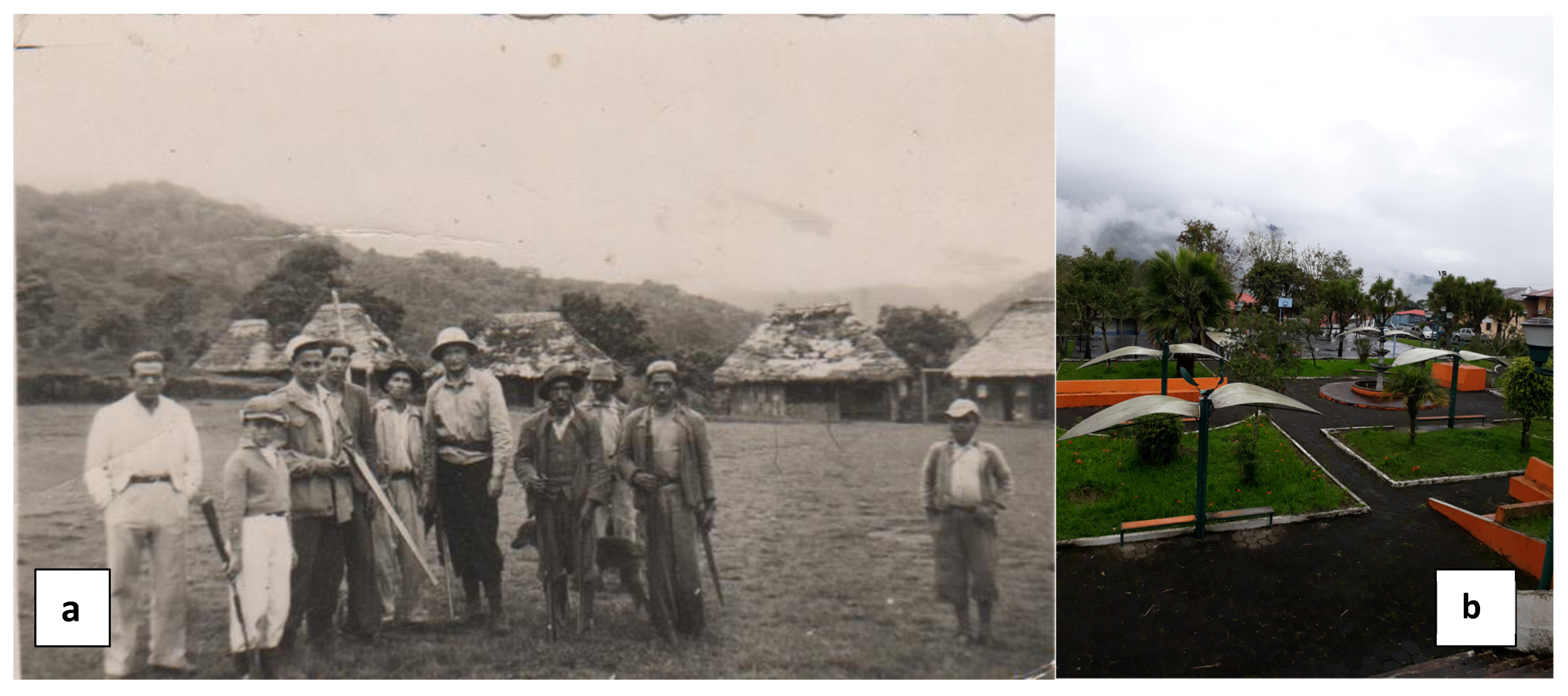
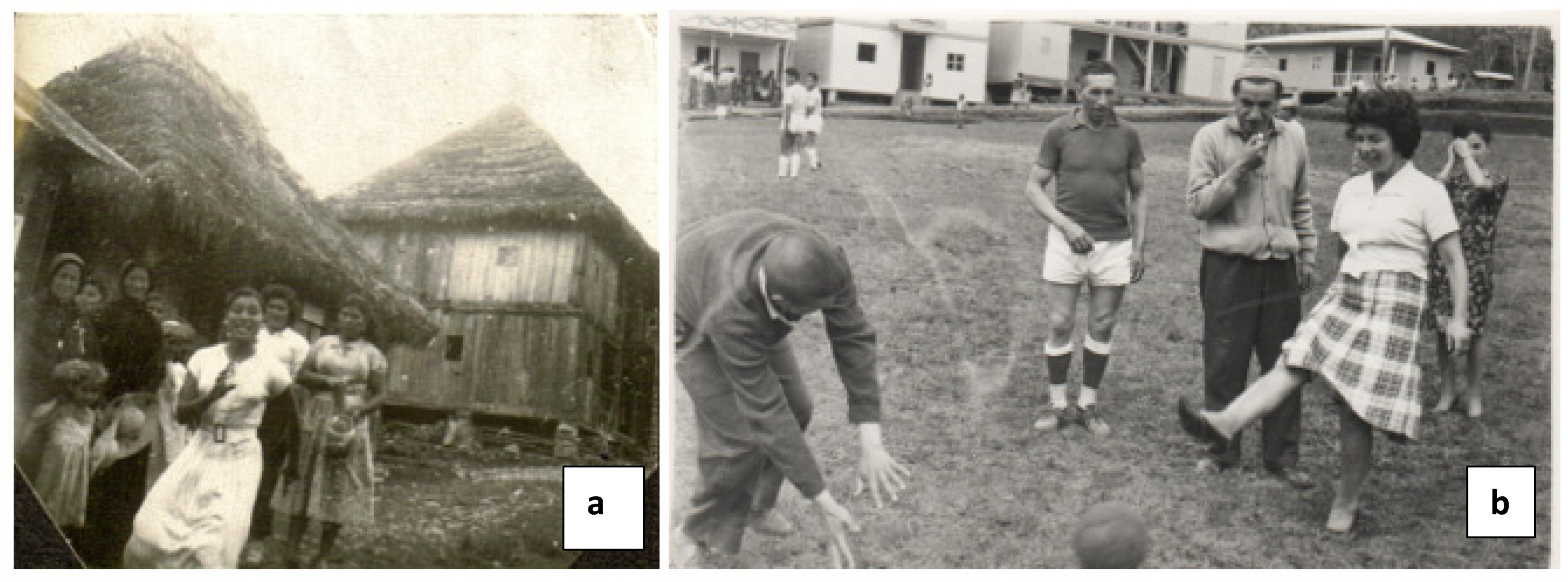
3.1. Pre-Hispanic Settlements and Historicity
3.2. Forest Transformation Factors
4. Discussion
5. Conclusions
Author Contributions
Funding
Acknowledgments
Conflicts of Interest
References
- Sarmiento, F.O. Andean Treeline Dynamics and the Human Dimension of Landscape Change in the Andes. In Global Change in Mountain Regions; Price, M., Ed.; Sapiens Publishing: Wiltshire, UK, 2006; pp. 233–234. [Google Scholar]
- Sarmiento, F.O. Mountain Regions: Sustained livelihood for an increasing population? In Entwicklung und Ländlicher Raum; Schwerpunkt: Berge, Germany, 2001; pp. 16–18. [Google Scholar]
- Sarmiento, F.O. Contesting Páramo: Critical Biogeography of the Northern Andean Highlands; Kona Publishing: Charlotte, NC, USA, 2012; p. 150. [Google Scholar]
- Sarmiento, F.O. Restoration of Andean Montane Forests for Conservation and Development. In Forests in Sustainable Mountain Development: A State of Knowledge Report for 2000; Price, M., Butt, N., Eds.; CABI Publications: Oxford, UK, 2000; pp. 59–69. [Google Scholar]
- Chaurette, E.; Sarmiento, F.O.; Rodríguez, J. A protected landscape candidate in the Tropical Andes of Ecuador. Parks 2003, 13, 42–51. [Google Scholar]
- Klein, J.A.; Tucker, C.M.; Nolin, A.W.; Hopping, K.A.; Reid, R.S.; Steger, C.; Grêt-Regamey, A.; Lavorel, S.; Müller, B.; Yeh, E.T.; et al. Catalyzing transformations to sustainability in the world’s mountains. Earth’s Future 2019, 7, 547–557. [Google Scholar] [CrossRef]
- Naveh, Z.; Lieberman, A.; Sarmiento, F.O.; Ghersa, C. Ecología de Paisajes. Teoría y Aplicación. Edición de Estudiantes; Editorial Universitaria de Buenos Aires (EUDEBA): Buenos Aires, Argentina, 2002; p. 571. [Google Scholar]
- Sarmiento, F.O. Identity, imaginaries and ideality: Understanding the biocultural landscape of the Andes through the iconic Andean lapwing (Vanellus resplendens). Rev. Chil. Ornitol. 2016, 22, 38–50. [Google Scholar]
- Hughes, H.; Vadrot, A.B.M. Weighting the World: IPBES and the Struggle over Biocultural Diversity. Glob. Environ. Politics 2019, 19, 14–37. [Google Scholar] [CrossRef]
- Subramanian, M.S.; You, E.; Dasgupta, R.; Takahashi, Y.; Deja, E.; Dublin, D.; Natori, Y.; Sarmiento, O.F.; Osei-Owusu, Y.; Quintero-Ángel, A.; et al. How multiple values influence decisions on sustainable use in socio-ecological production landscapes and seascapes. Satoyama Rev. 2019, 5, 1–15. [Google Scholar]
- Brown, J.; Mitchell, N.; Sarmiento, O.F. Landscape Stewardship: New Directions in Conservation of Nature and Culture. Georg. Wright Forum 2000, 17, 70–79. [Google Scholar]
- Brouwer, R.G.; Zuidema, P.A.; Chiriboga-Arroyo, F.; Guariguata, M.R.; Kettle, C.J.; Ehrenberg-Azcárate, F.; Quaedvlieg, J.; Roca, M.R.G.; Corvera-Gomringer, R.; Quispe, F.V.; et al. Establishment success of Brazil nut trees in smallholder Amazon forest restoration depends on site conditions and management. For. Ecol. Manag. 2021, 498, 119575. [Google Scholar] [CrossRef]
- Kowler, L.F.; Kumar Pratihast, A.; Pérez Ojeda del Arco, A.; Larson, A.M.; Braun, C.; Herold, M. Aiming for sustainability and scalability: Community engagement in forest payment schemes. Forests 2020, 11, 444. [Google Scholar] [CrossRef] [Green Version]
- Farley, K.A. Pathways to forest transition: Local case studies from the Ecuadorian Andes. J. Lat. Am. Geogr. 2010, 9, 7–26. [Google Scholar] [CrossRef]
- Sarmiento, O.F.; Hitchner, S. Indigeneity and the Sacred: Indigenous Revival and the Conservation of Sacred Natural Sites in the Americas; Berghahn Books: New York, NY, USA, 2019; p. 266. [Google Scholar]
- Amend, T.; Brown, J.; Kothari, A.; Phillips, A.; Stolton, S. Protected Landscapes and Agrobiodiversity Values. In Protected Landscapes and Seascapes; Kaspareg Verlag: Heidelberg, Germany, 2008; Volume 1, p. 139. [Google Scholar]
- Sarmiento, O.F.; Rodríguez, G.; Argumedo, A. Cultural landscapes of the Andes: Indigenous and colono culture, traditional knowledge and ethno-ecological heritage. In The Protected Landscape Approach: Linking Nature, Culture and Community; Brown, J., Mitchell, N., Beresford, M., Eds.; IUCN—The World Conservation Union: Gland, Switzerland, 2005. [Google Scholar]
- Noulèkoun, F.; Mensah, S.; Birhane, E.; Son, Y.; Khamzina, A. Forest Landscape Restoration under Global Environmental Change: Challenges and a Future Roadmap. Forests 2021, 12, 276. [Google Scholar] [CrossRef]
- Sarmiento, F.O. Protected landscapes in the Andean context: Worshipping the sacred in nature and culture. In The Full Value of Parks; Harmon, D., Putney, A., Eds.; Rowman & Littlefield Publishing Group: Lanham, MA, USA, 2003; pp. 239–249. [Google Scholar]
- Sarmiento, F.O.; Rodríguez, G.; Torres, M.; Argumedo, A.; Muñoz, M.; Rodríguez, J. Andean stewardship: Tradition linking nature and culture in protected landscapes of the Andes. Georg. Wright Forum 2000, 17, 55–69. [Google Scholar]
- Riggs, R.A.; Langston, J.D.; Nerfa, L.; Boedhihartono, A.K.; Gaston, C.; Herdianti, A.R.; Valeri, E.; Sayer, J. Common ground: Integrated landscape approaches and small and medium forest enterprises for vibrant forest landscapes. Sustain. Sci. 2021, 16, 2013–2026. [Google Scholar] [CrossRef]
- Sarmiento, F.O. The Quijos River Valley: A protected landscape as best management practice for conservation and development in Tropandean Ecuador. Georg. Wright Forum 1997, 14, 59–66. [Google Scholar]
- Sarmiento, F.O. Agrobiodiversity in the farmscapes of the Quijos River in the Tropical Andes, Ecuador. In Protected Landscapes and Agrobiodiversity Values; Amend, T., Brown, J., Kothari, A., Phillips, A., Stolton, S., Eds.; Kaspareg: Heidelberg/Berlin, Germany, 2008; p. 20. [Google Scholar]
- Encalada, A.C.; Flecker, A.S.; Poff, N.L.; Suárez, E.; Herrera-R, G.A.; Ríos-Touma, B.; Jumani, S.; Larson, E.I.; Anderson, E.P. A global perspective on tropical montane rivers. Science 2019, 365, 1124–1129. [Google Scholar] [CrossRef]
- Myster, R. The Andean Cloud Forest; Springer: Cham, Switzerland, 2021. [Google Scholar]
- Gutiérrez, W. Baeza, la Ciudad de los Quijos: Su Historia Desde el Siglo XVI al Siglo XIX; Proyecto Gran Sumaco, Ministerio del Ambiente—GTZ: Quito, Ecuador, 2002.
- Ellenberg, H. Man’s influence on tropical mountain ecosystems of South America. J. Ecol. 1979, 67, 401–416. [Google Scholar] [CrossRef]
- Huisman, N.S.; Bush, B.M.; McMichael, N.C. Four centuries of vegetation change in the mid-elevation Andean forests of Ecuador. Veg. Hist. Archaeobotany 2019, 28, 679–689. [Google Scholar] [CrossRef] [Green Version]
- Grubb, J.R.; Lloyd, R.J.; Pennington, D.T.; Whitmore, C.J. A comparison of montane and lowland rain forests in Ecuador I. The forest structure, physiognomy and floristics. J. Ecol. 1966, 51, 567–601. [Google Scholar] [CrossRef]
- Grubb, J.P.; Whitmore, C.T. A comparison of montane and lowland rain forest in Ecuador: II. The climate and its effects on the distribution and physiognomy of the forests. J. Ecol. 1966, 54, 303–333. [Google Scholar] [CrossRef]
- Sarmiento, O.F.; Viteri, X. Discursive Heritage: Sustaining Andean Cultural Landscapes Amidst Environmental Change. In Conserving Cultural Landscapes: Challenges and New Directions; Taylor, K., Clair, A.S., Mitchell, N.J., Eds.; Routledge: New York, NU, USA, 2015. [Google Scholar]
- Moret, P.; Muriel, P.; Jaramillo, R.; Dangles, O. Humboldt’s Tableau Physique revisited. Proc. Natl. Acad. Sci. USA 2019, 116, 12889–12894. [Google Scholar] [CrossRef] [Green Version]
- Sarmiento, F.O. Anthropogenic landscape change in highland Ecuador. Geogr. Rev. 2002, 92, 213–234. [Google Scholar] [CrossRef]
- Rahbek, C.; Borregaard, K.M.; Colwell, K.R.; Dalsgaard, B.; Holt, G.B.; Morueta-Holme, N.; Nogues-Bravo, D.; Whittaker, J.R.; Fjeldså, J. Humboldt’s enigma: What causes global patterns of mountain biodiversity? Science 2019, 365, 1108–1113. [Google Scholar] [CrossRef]
- Hamilton, L.S. The role of protected areas in sustainable mountain development. Parks 1996, 6, 2–13. [Google Scholar]
- Sarmiento, C.A. Biografía del Río Napo; Editorial Fray Jodoko Rike: Quito, Ecuador, 1952. [Google Scholar]
- Sarmiento, C.A. Monografía Científica del Oriente Ecuatoriano; Editorial Don Bosco: Quito, Ecuador, 1957. [Google Scholar]
- Sarmiento, F.O. Antología Ecológica del Ecuador: Desde la Selva Hasta el Mar; Casa de la Cultura Ecuatoriana: Quito, Ecuador, 1987; p. 382. [Google Scholar]
- Pugh, J.; Sarmiento, F. Selling the public on sustainable watershed conservation. Bull. Lat. Am. Res. 2004, 23, 322–337. [Google Scholar] [CrossRef]
- Sarmiento, F.O. Restauración de Paisajes Tropandinos: El Desafío Para la Conservación de Áreas Frágiles en los Andes Tropicales. In Desarrollo Sostenible de Ecosistemas de Montaña: Manejo de Áreas Frágiles en los Andes; Liberman, M., Baeid, C., Eds.; Didier Genin: La Paz, Bolivia, 1997; pp. 375–383. [Google Scholar]
- Wuetrich, B. Forests in the clouds face stormy future. Sci. News 1993, 144, 23. [Google Scholar] [CrossRef]
- Sarmiento, F.; Sarmiento, E.V. Flancos Andinos: Paleoecología, Biogeografía Crítica y Ecología Política de los Climas Cambiantes de los Bosques Neotropicales de Montaña; Editorial Universidad Nacional Toribio Rodríguez de Mendoza de Amazonas (UNTRM): Chachapoyas, Peru, 2021. [Google Scholar]
- Sarmiento, F.O. Ecuador. In Bosques Nublados del Neotrópico; Kapelle, M., Brown, A., Eds.; National Institute of Biodiversity (InBIO): San José, Costa Rica, 2001; pp. 497–548. [Google Scholar]
- Appenzeller, T. Fire on the mountain. Science 2019, 365, 1094–1097. [Google Scholar] [CrossRef] [PubMed]
- Takahashi, Y.; Park, K.J.; Natori, Y.; Dublin, D.; Dasgupta, R.; Miwa, K. Enhancing synergies in nature’s contributions to people in socio-ecological production landscapes and seascapes: Lessons learnt from ten site-based projects in biodiversity hotspots. Sustain. Sci. 2021, 3, 1–14. [Google Scholar] [CrossRef]
- Uzendoski, M.A. The Horizontal Archipelago: The Quijos/Upper Napo Regional System. Ethnohistory 2004, 51, 317–357. [Google Scholar] [CrossRef]
- Cuéllar, A.M. The Organization of Agricultural Production in the Emergence of Chiefdoms in the Quijos Region, Eastern Andes of Ecuador. Ph.D. Thesis, University of Pittsburg, Pittsburgh, PA, USA, 2005. [Google Scholar]
- Loughlin, N.J.D.; Gosling, W.D.; Mothes, P.; Montoya, E. Ecological consequences of post-Columbian indigenous depopulation in the Andean–Amazonian corridor. Nat. Ecol. Evol. 2018, 2, 1233–1236. [Google Scholar] [CrossRef]
- Sarmiento, F.O. Human impacts in man-aged tropandean landscapes: Breaking mountain paradigms. AMBIO 2000, 29, 423–431. [Google Scholar] [CrossRef]
- Sarmiento, O.F.; Frolich, L. Andean Cloud Forest Treelines: Naturalness, Agriculture and the Human Dimension. Mt. Res. Dev. 2002, 22, 278–287. [Google Scholar] [CrossRef] [Green Version]
- Sarmiento, F.O. Research in tropandean protected areas of Ecuadorian landscapes. Georg. Wright Forum 1992, 9, 148–160. [Google Scholar]
- Cañadas, L. El Mapa Ecológico y Bioclimático del Ecuador; Mag-Pronareg: Quito, Ecuador, 1983. [Google Scholar]
- Newson, L. Patterns of Indian depopulation in early colonial Ecuador. Rev. Indias 2003, 63, 135–157. [Google Scholar]
- Newson, L. The population of the Amazon Basin in 1492: A view from the Ecuadorian headwaters. Trans. Inst. Br. Geogr. 1996, 21, 9–15. [Google Scholar] [CrossRef]
- Subramanian, S.M.; You, E.; Leimona, B.; Villanueva, A.B.; Díaz-Varela, E.R.; Chao, J.-T.; Lee, L.L.; Tschentscher, T.; Calispa Quinto, A.N.; Dublin, D.; et al. Enhancing effective area-based conservation through the sustainable use of biodiversity in socio-ecological production landscapes and seascapes (SEPLS). Satoyama Rev. 2018, 4, 1–13. [Google Scholar]
- Jonas, H.D.; Barbuto, V.; Kothari, A.; Nelson, F. New Steps of Change: Looking Beyond Protected Areas to Consider Other Effective Area-Based Conservation Measures. Parks 2014, 20, 111–128. [Google Scholar] [CrossRef]
- Sarmiento, F.O. The birthplace of ecology: Tropandean ecoregion of Ecuador, an endangered landscape. Environ. Conserv. 1997, 24, 3–4. [Google Scholar] [CrossRef]
- Levin, G.; Reenberg, A. Land use driven conditions for habitat structure: A case study from the Ecuadorian Andes. Geogr. Tidsskr. J. Geogr. 2002, 102, 79–92. [Google Scholar] [CrossRef]
- Sweet, D.G. The Population of the Upper Amazon Valley in the 17th and 18th Centuries. Master’s Thesis, University of Wisconsin, Madison, WI, USA, 1969. [Google Scholar]
- Oberem, U. Geschichte und Kulturwandel der Indianer zwischen den Flüssen Napo und Coca in Ost-Ekuador. Unpublished. Ph.D. Thesis, Bonn University, Bonn, Germany, 1962; pp. 10–15. [Google Scholar]
- Knapp, G. Ecología Cultural Prehispánica del Ecuador; Banco Central del Ecuador: Quito, Ecuador, 1988. [Google Scholar]
- Porras, P. Nuestro Ayer: Manual de Arqueología Ecuatoriana; Pontificia Universidad Católica del Ecuador: Quito, Ecuador, 1987. [Google Scholar]
- Bustamante-Cárdenas, S. Sobre las Huellas de Orellana; OCP-Ecuador: Quito, Ecuador, 2006. [Google Scholar]
- Cuéllar, A. The Quijos Chiefdoms: Social Change and Agriculture in the Eastern Andes of Ecuador; Memoirs in Latin American Archaeology; University of Pittsburgh: Pittsburgh, PA, USA, 2009; Volume 20, pp. 5–15. [Google Scholar]
- Drennan, R. Las Sociedades Prehispánicas del Alto Magdalena; Instituto Colombiano de Antropología e Historia: Bogotá, Colombia, 2006.
- Herzog, I.; Yepez, A. Analyzing Patterns of Movement and of Settlement in the East-Andean Mountains of Ecuador. In Proceedings of the 19th International Conference on Cultural Heritage and New Technologies, Vienna, Austria, 3–5 November 2014. [Google Scholar]
- Sanchez, R.; Hidalgo, R.; Arenas, F. Re-Conociendo las Geografías de América Latina y el Caribe; Pontifical Catholic University of Chile: Santiago, Chile, 2017. [Google Scholar]
- Porras, P. Fase Cosanga; Centro de Publicaciones de la Universidad Católica de Quito: Quito, Ecuador, 1975. [Google Scholar]
- Sarmiento, F.O.; Gonzalez, J.A.; Lavilla, E.O.; Donoso, M.; Ibarra, J.T. Onomastic misnomers in the construction of faulty Andeanity and week Andeaness: Biocultural Microrefugia in the Andes. Pirin. J. Mt. Ecol. 2019, 174, 1–16. [Google Scholar]
- Yépez, A. Die Keramik aus dem Quijos-Tal: Wandel und Kontinuität der Keramik aus den Flusstälern von Cosanga und Quijos, Provinz Napo, Ecuador; Rheinische Friedrich-Wilhelms Universität zu Bonn: Bonn, Germany, 2008; 359p. [Google Scholar]
- Herzog, I.; Yépez, A. Covering Distances in the East Andean Mountains. In Inca News—Innovation in Andean Research; Szemiński, J., Moscovich, V., Afik, B., Eds.; Archaeopress: Oxford, UK, 2014. [Google Scholar]
- U.S. Agency for International Development. Sustainable Use of Biological Resources. Program Cycle Overview. Available online: https://pdf.usaid.gov/pdf_docs/Pdacs774.pdf (accessed on 22 November 2021).
- Church, W. Prehistoric Cultural Development and Interregional Interaction in the Tropical Montane Forests of Peru. Ph.D. Thesis, Yale University, New Haven, CT, USA, 1996. [Google Scholar]
- Bridgewater, P. The intergovernmental platform for biodiversity and ecosystem services (IPBES)—A role for heritage? Int. J. Heritage Stud. 2016, 23, 65–73. [Google Scholar] [CrossRef]
- Díaz, S.; Demissew, S.; Carabias, J.; Joly, C.; Lonsdale, M.; Ash, N.; Larigauderie, A.; Adhikari, J.R.; Arico, S.; Báldi, A.; et al. The IPBES Conceptual Framework—Connecting nature and people. Curr. Opin. Environ. Sustain. 2015, 14, 1–16. [Google Scholar] [CrossRef] [Green Version]
- Zhu, L.; Lo, K. Non-timber forest products as livelihood restoration in forest conservation: A restorative justice approach. Trees People 2021, 6, 100130. [Google Scholar] [CrossRef]
- Worboys, G.L.; Francis, W.L.; Lockwood, M. Connectivity Conservation Management: A Global Guide; Earthscan: London, UK, 2010; p. 382. [Google Scholar]


Publisher’s Note: MDPI stays neutral with regard to jurisdictional claims in published maps and institutional affiliations. |
© 2021 by the authors. Licensee MDPI, Basel, Switzerland. This article is an open access article distributed under the terms and conditions of the Creative Commons Attribution (CC BY) license (https://creativecommons.org/licenses/by/4.0/).
Share and Cite
Sarmiento, F.O.; Rodríguez, J.; Yepez-Noboa, A. Forest Transformation in the Wake of Colonization: The Quijos Andean Amazonian Flank, Past and Present. Forests 2022, 13, 11. https://doi.org/10.3390/f13010011
Sarmiento FO, Rodríguez J, Yepez-Noboa A. Forest Transformation in the Wake of Colonization: The Quijos Andean Amazonian Flank, Past and Present. Forests. 2022; 13(1):11. https://doi.org/10.3390/f13010011
Chicago/Turabian StyleSarmiento, Fausto O., Jack Rodríguez, and Alden Yepez-Noboa. 2022. "Forest Transformation in the Wake of Colonization: The Quijos Andean Amazonian Flank, Past and Present" Forests 13, no. 1: 11. https://doi.org/10.3390/f13010011
APA StyleSarmiento, F. O., Rodríguez, J., & Yepez-Noboa, A. (2022). Forest Transformation in the Wake of Colonization: The Quijos Andean Amazonian Flank, Past and Present. Forests, 13(1), 11. https://doi.org/10.3390/f13010011