Article

The Mediterranean Old-Growth Forests: Anomalies or Relicts? The Contribution of Soil Charcoal Analysis

1
LIEC, CNRS, Lorraine University, 57070 Metz, France
2
Institute for Ecosystem Research, CRC 1266, Kiel University, 24118 Kiel, Germany
3
IMBE, CNRS, IRD, Aix-Marseille University, Avignon University, 13290 Aix-en-Provence, France
*
Author to whom correspondence should be addressed.
Forests 2021, 12(11), 1541; https://doi.org/10.3390/f12111541
Submission received: 14 October 2021 / Revised: 3 November 2021 / Accepted: 5 November 2021 / Published: 8 November 2021
(This article belongs to the Special Issue Past Environmental Changes and Forest Conservation)

Abstract

:
Old-growth forests are of high interest for biodiversity conservation, especially in the disturbance-prone Mediterranean landscapes. However, it remains unclear whether the survival of patches of old-growth forest in the degraded Mediterranean landscapes results from local anomalies or from past, larger forests. Therefore, in this study, we assessed (1) the origin, (2) the long-term ecological trajectory, and (3) the mechanism(s) that explain the survival of a Mediterranean old-growth forest, the Sainte-Baume forest. To achieve this, we used soil charcoal analysis. We opened fifteen soil profiles in the forest and five in its surrounding areas for soil description and sampling. The soil descriptions enabled us to highlight in situ soil horizon and colluvial layers. A total of 1656 charcoal pieces from different soil samples were taxonomically identified to characterize the composition of past forests. Selected charcoal pieces (n = 34) were dated to obtain chronological data. Our investigations indicate that the survival of the Mediterranean old-growth forest, in the context of the semi-open/open Mediterranean landscapes, is the result of a combination of biotic and abiotic factors, which reduced the influence of past forest disturbances. Thus, the resistance and resilience of the forest areas are preserved over a long-term ecological trajectory. Therefore, the potential of Mediterranean old-growth forests as baseline reference points for the conservation of biodiversity is related to the identification and maintenance of the local biotic and abiotic factors which allowed the survival of the old-growth forest.

1. Introduction

Old-growth forests are of high interest in terms of both biodiversity conservation [1,2,3] and climate mitigation [4,5,6], due to their specific structure, function and composition. This is especially true in disturbance-prone landscapes [7,8,9]. This is particularly the case in the Mediterranean basin, in which the joint effects of ancient and significant human activities and climatic constraints have caused the widespread presence of semi-open to open ecological systems, with too-short disturbance return intervals to allow the development of mature forest [10,11,12,13]. Nevertheless, in this area, several isolated woodland patches have been recognized that present features of old-growth forest [3,10,14,15,16].
To date, it remains unclear whether the survival of these old-growth forest patches in the degraded Mediterranean landscape results from local anomalies, or whether they are the relict patches of forests that had a larger spatial distribution in the past and which have been affected to achieve degraded forest status. This is a key question, since, in the latter case, the old-growth forests might play a significant role for forest conservation at the Mediterranean basin scale, as a baseline reference. Therefore, it is of great importance that the origin and long-term trajectories of the Mediterranean old-growth forests are assessed.
However, despite a large number of paleoecological and biogeographical investigations in the area, the issue remains poorly understood. This is probably because, in the Mediterranean basin, old-growth forests are rare, isolated and restricted to small areas [3,10]. As a consequence, their past dynamics are blurred compared with the insights garnered from the larger-scale sites studied in most paleoecological investigations. In addition, the insights on such patches of old-growth forest are also limited in terms of spatial resolution because, in the context of the Mediterranean region, archives of records of classical paleo-indicators, such as pollen grains, are rare. Therefore, to investigate the origin and the long-term trajectory of Mediterranean old-growth forests, and the mechanisms that have enabled them to survive until today, it was necessary for us to apply an approach that permitted the investigation of the forest’s long-term history at a local scale. To this end, we used soil charcoal records that are particularly relevant at a stand scale [17,18,19] and which provide local information about the past fire regime and forest composition [20,21,22]. By conducting this investigation in an area of the Sainte-Baume forest with a clear distinction between a patch of old-growth forest and a matrix of degraded forest states (i.e., secondary successional forest states), a comparison was enabled of three sharply demarcated general ecological units, with the patch of old-growth forest surrounded by semi-open/open ecosystems.
Within that study area, soil samples were taken from each ecological unit for soil charcoal analysis, in order to assess (1) the origin, (2) the long-term trajectory, and (3) the mechanism(s) operating to explain the survival of the old-growth forest in the Mediterranean context of an open/semi-open landscape.

2. Materials and Methods
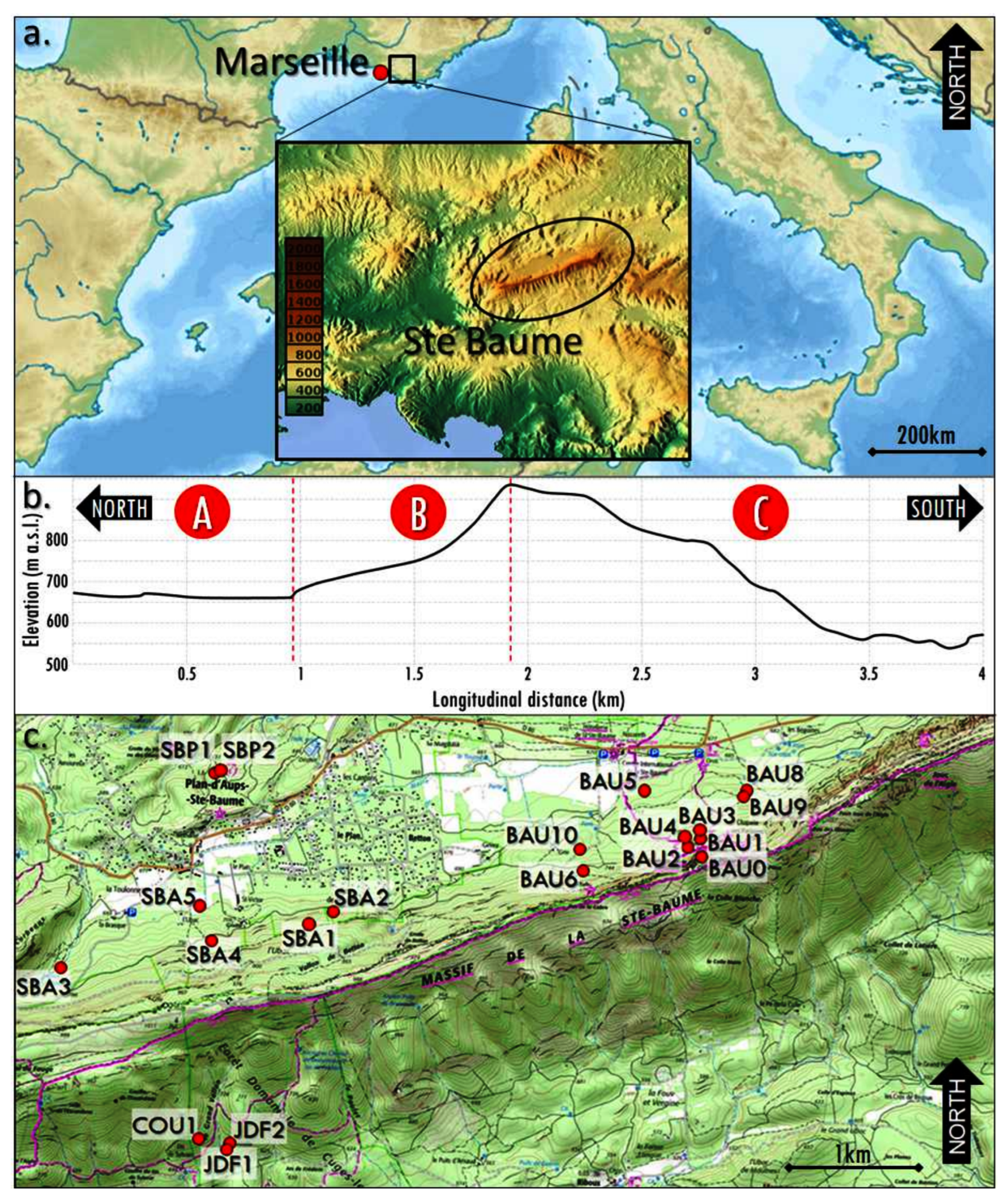
2.1. The Study Area

The study area is located on the northwestern side of the Mediterranean basin, in southern France (Figure 1a), in the calcareous Provence region [23]. The geological sub-stratum consists of limestones, from hard and compact to soft and easily erodible (i.e., marls; [24]), with karstic systems [25,26].
The climate in the study area corresponds to a climate typical of Mediterranean mountains, with relatively cool and moist winters, and warm, dry summers [27]. The local meteorological station records an average annual rainfall of 950 mm and a mean annual temperature of 10 °C [24]. However, considering the Sainte-Baume area and its surroundings included in the study area, the climatic conditions may vary greatly, due to the heterogeneity of the physical factors. Indeed, the study area is composed of three different ecological units (Figure 1b) based on variations in elevation, exposure, topography, vegetation distribution and soil type.
First, to the north of the Sainte-Baume Forest is a plateau between 650 and 700 m above sea level (a.s.l.). It is covered mainly by pioneer coniferous woodland dominated by pine (Pinus sylvestris) and juniper (Juniperus communis and Juniperus oxycedrus). Local soils are skeletal soils, rich in calcareous stones of various sizes, corresponding to skeletic rendzic regosols.
In the center of the study area is the old-growth forest of Sainte-Baume, between 700 and 850 m a.s.l., on a small site at the bottom of a calcareous cliff about 300 m high. This is a mix of deciduous broadleaf and coniferous forest with mesophilic traits [24]. More precisely, at the bottom of the cliff is a first belt of forest several tens of meters wide, dominated by beech (Fagus sylvatica) and yew (Taxus baccata), with a few silver fir trees (Abies alba; [28]). In this part of the old-growth forest, Fagus trees have been dated by dendroecological measurements to be about 200 years old (i.e., among 45 trees, the oldest is 249 years and the mean age is 182 years [29]).
Farther from the cliff, toward the northern plateau, is a second forest belt dominated by downy oaks (Quercus pubescens) with maple (Acer spp.) and lime trees (Tilia spp.; [24]). The local soils here are mostly deep, rich in organic matter and corresponding to cambisols.
Finally, on the southern side of the cliff, is an area of gently to locally steeply sloping land, from 900 to 650 m a.s.l. There, the vegetation is a typical calcareous Mediterranean scrubland with Aleppo pine (Pinus halepensis), evergreen kermes and holm oaks (Quercus coccifera and Quercus ilex, respectively), junipers (Juniperus spp.), gray-leaved cistus (Cistus albidus), rosemary (Rosmarinus officinalis) and strawberry tree (Arbutus unedo) [24,30,31,32,33]. Local soils here are comparable with those present on the northern plateau of the study area, i.e., rendzic regosols soils, but also locally with deep sedimentary accumulation (possibly greater than 1 m), in small stream/valley bottoms (colluvic soils), whereas, on relief ridges, soils are absent, and the calcareous substrate is directly on the surface (skeletal soils).

2.2. Local History

Little is known about pre-historical presence in the Sainte-Baume area. However, in the soundings of the study area, several archeological sites indicate the ancient presence of humans, such as the Neolithic site of the “Clos des Roques” c. 30 km northeast of the Sainte-Baume, or the Mesolithic grave of Cuges-les-Pins on the west of the southern side of the Sainte-Baume cliff [34]. Other studies have shown the presence of Roman road networks, which connected the Huveaune Valley, north of the investigated plateau of the Sainte-Baume, to the ancient city of Marseille [35]. At the regional level, very dense occurrences of Roman structures have been found and studied, such as villas or oppidum [36].
During the XIII century, a monastery was constructed in the Sainte-Baume forest [37], which gave a sacred statute to the forest. Therefore, from that period, the forest was protected [24]. Hunting, grazing and wood harvesting were prohibited [38]. Only after the French Revolution, when clergy’s land ownership was given to the local population, was the forest exploited [37,38,39,40]. This continued until 1973, when the forest became a biological reserve [33]. Since 2017, the area has been included as a nature regional park, and since 2018, the forest area has been recognized nationally as “exceptional woodland”.
Finally, it is interesting to note that, during the XVII and XVIII centuries, the area sur-rounding the Sainte-Baume Forest was an important source of ice (in stone coolers), lime for lime ovens and charcoal production, with sites that are still visible today in the field [41].

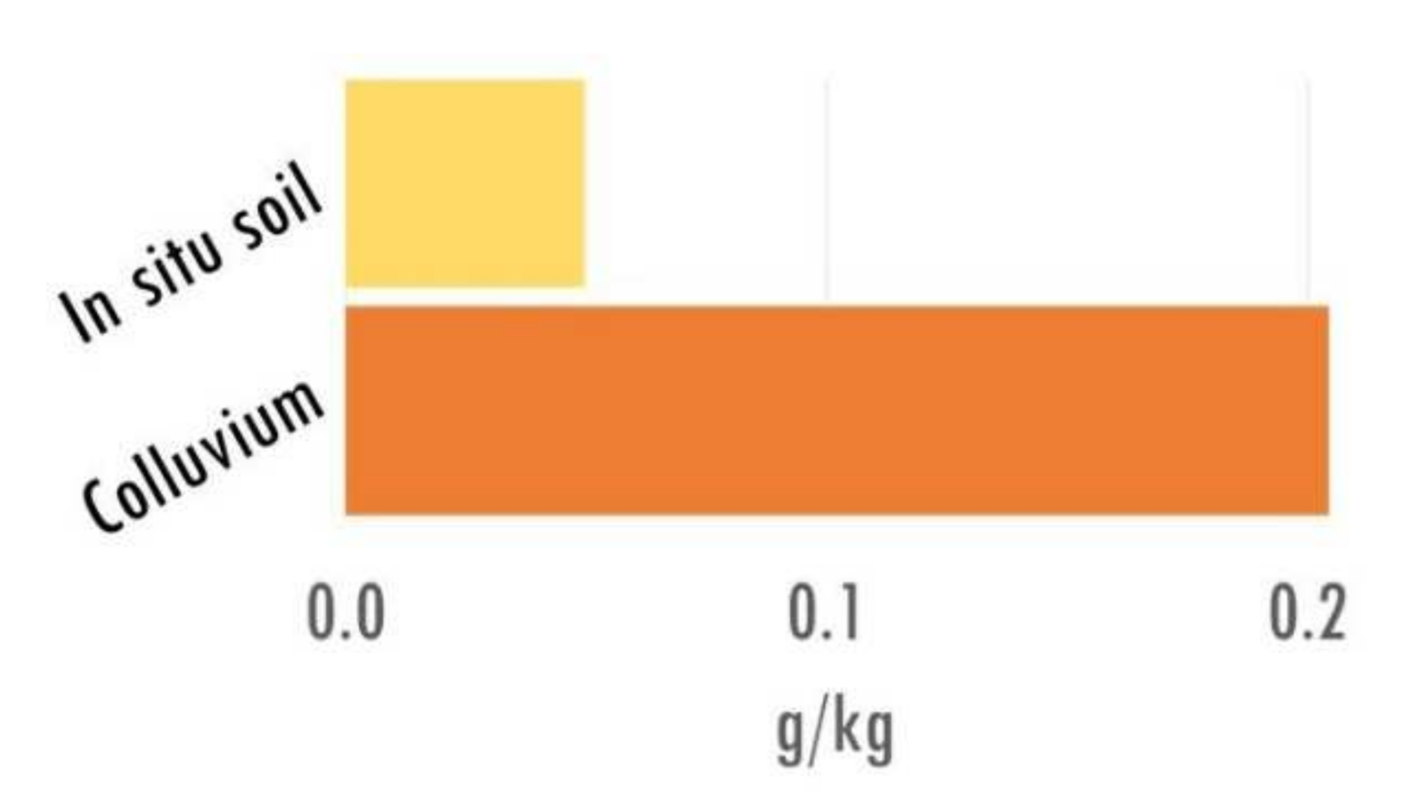
2.3. Sampling Strategy and Soil Description

The sampling strategy was designed to take account of the three ecological units of the study area (Figure 1). However, because our research focus was on the issue of the old-growth forest, the main effort of sampling was carried out in the Sainte-Baume forest, where 15 soil profiles were sampled along an east–west axis. To investigate the surroundings of the current distribution area of the old-growth forest, two soil profiles on the northern plateau and three soil profiles on the southern exposure of the cliff were sampled (Figure 1c).
All the soil profiles were opened manually to a length of 1–2 m and down to the bedrock. Each soil profile was cleaned and documented with scale drawings. Soil horizons and colluvial layers were distinguished and described according to the properties observable in the field (i.e., color, texture, structure, etc. [42,43,44]). Once the soil profile had been documented, c. 10 L of soil/soil sediment was taken for charcoal extraction. The samples were taken from the base to the top of the horizon, following the identified sediment layers or soil horizons, with a maximum height of 10 to 20 cm per sample to maintain a fine vertical resolution of sampling [22].

2.4. Soil Charcoal Identification

Taxonomic charcoal analysis was carried out on charcoal pieces larger than 1 mm which were extracted from the soil samples. We focused on these “mega-charcoal” pieces because they were large enough to be identifiable taxonomically [45], and because they were of local resolution, according to the catchment topography [17,18,22].
The extraction of the charcoal pieces from the soil samples was carried out using the protocol described by [46,47]. First, the samples were wet-sieved to separate the mineral fraction from the organic matter, the latter containing most of the charcoal pieces, which are low in density, floating readily. The mineral fraction was rinsed several times until the floating charcoal pieces were extracted and added to the organic fraction. Finally, the extracted organic fraction was dry-sieved using three different mesh sizes: 1–2 mm, 2–5 mm and >5 mm.
The taxonomic identification of the charcoal pieces was performed using wood anatomy criteria, because wood anatomy is fixed by carbonization [22]. The identification of both the genus and species level is possible if the charcoal pieces are not too dirty (e.g., covered in loamy sediment) and/or over-transformed (vitrified charcoal [48]). Identification keys, wood anatomy atlases [49,50,51] and the charcoal reference collections of the LIEC-University of Lorraine and of the IMBE-Aix-Marseille University were used to achieve taxonomic identification. The criteria were assessed under a stereoscopic microscope at 10× to 75× magnification and an episcopic microscope at 200×, 500× and 1000× magnifications, for up to 90 charcoal pieces per sample, taken at random, equal proportions in each of the three size fractions.

2.5. Charcoal Data Handling

Because of the mixing of soil from different layers over time [52,53,54], the results of the taxonomic analysis in this study are expressed as a proportion of taxon occurrence (i.e., taxon frequency) from the extracted charcoal assemblages per soil profile (with all depths cumulated). The absolute quantities of charcoal per sampled layer of sediment or soil horizon were not considered in this study. The only analysis related to the depth of sampling was used to compare the charcoal richness in colluvial layers vs. in situ soil horizons. For these latter data, the dry weight of the charcoal fraction (at 60 for at least 72 h), after extraction from the samples, was obtained and soil charcoal concentration was expressed relative to the dry weight of the corresponding sample, cumulated per colluvial layer and per in situ soil horizon [22].
The analysis of the taxonomical data was carried out through multivariate analysis. First, we used a cluster analysis to look at the frequency of every identified taxa per sampled soil profile. This cluster analysis was based on Euclidean similarity measures, proceeded on ©PAST software [55]. Then, a correspondence analysis was performed of the frequencies of taxa according to sampled soil profiles for all three ecological units of sampling, related to the successional/autecological groups defined after the cluster analysis. This correspondence analysis was carried out using ©C2 software [56].

2.6. Chronological Analysis

Several single charcoal pieces, previously taxonomically identified, were selected for radiocarbon dating. The selection of the charcoal pieces to achieve 14C dating was performed according to (1) their significance to the overall charcoal taxonomic spectrum, and (2) the context of sampling from which they were obtained, to provide chronological data about the soil erosion history (i.e., the ages of the erosion events; [57,58,59]. The carbon-14 (14C) dating was carried out by accelerator mass spectrometry (AMS) at the Laboratory of Radiocarbon Measurement of Trondheim University in Norway (lab reference: Tra) and by the Poznań Radiocarbon Laboratory in Poland (lab reference: Poz). The radiocarbon ages were calibrated with a two-standard-deviation (2σ) 95% confidence interval on the OxCal program [60], using the IntCal20 dataset [61].

3. Results

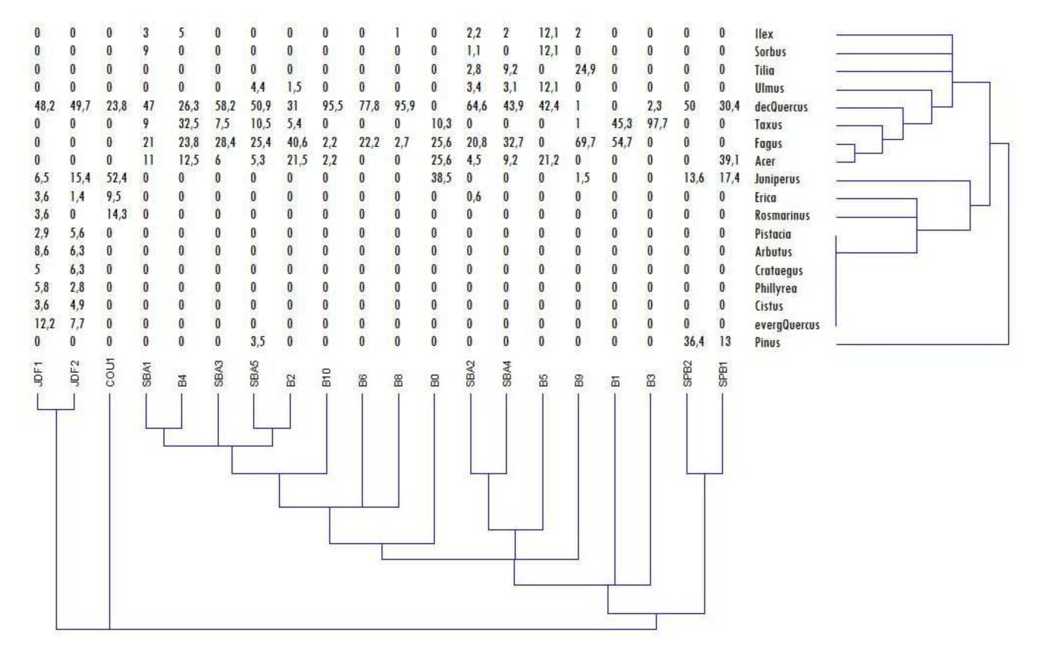
3.1. Soil Description and Charcoal Richness

Only seven of the 20 sampled soil profiles contained in situ soil horizons, with one or two distinguishable horizons, Ah and/or Bw, covered by colluvial layers. The 13 remaining soil profiles sampled contained only colluvial layers of varying thicknesses (from a few centimeters to several tens of centimeters; Table 1).
Consequently, more samples have been taken from colluvial layers (i.e., 56 samples, providing a total of 281 kg of sediment) than from in situ soil horizons (i.e., 17 samples, providing a total of 70 kg of soil). Nevertheless, the charcoal record, expressed in concentrations (i.e., mg of charcoal >1 mm per kg of sampled soil or sediment), enabled us to compare the charcoal richness of samples by the type of archive (e.g., soil versus soil sediment). Thus, it can be seen that the total charcoal concentration in the colluvial layers was more than four times the charcoal concentration in the in situ soil horizons (Figure 2). This observation was consistent for the three ecological units sampled in the study area.
The absolute quantities of charcoal per sampled layer of sediment or soil horizon were not considered in this study because of the considerable biotic and abiotic heterogeneities of the sampling areas. These heterogeneities may have resulted in large variation in the previous fire regime, possibly strongly influencing the charcoal record (e.g., the type and amount of fuel, topography, wind exposure, etc. [62]). Moreover, the charcoal record was not related to the depth of sampling because soils are not chronologically stratified paleoarchives. Both physical (e.g., uprooting; [54,63]) and biological processes (e.g., bioturbation; [52,64]) are potential sources of soil mixing. This appears to be particularly relevant in an area with marked relief [53], where the interpretation of chronological data from charcoal records related to depth of sampling should be subject to considerable caution [65].

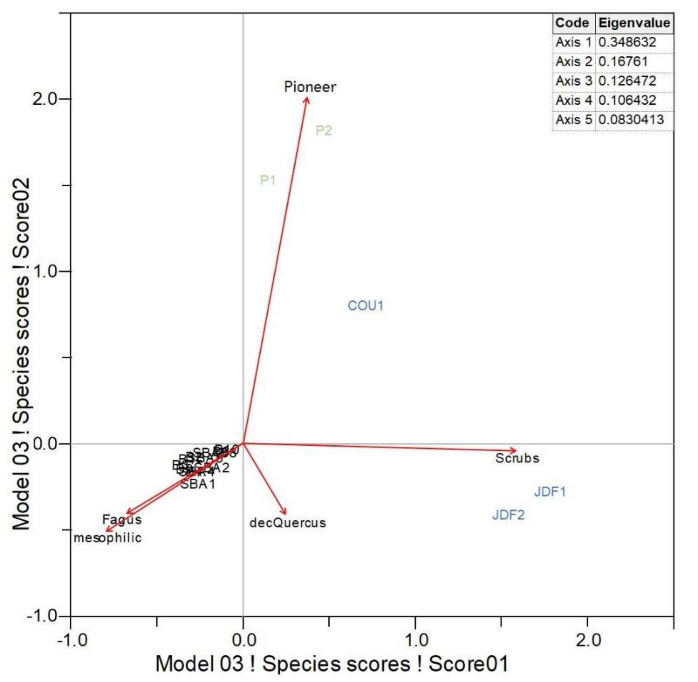
3.2. Taxanomical Analysis

A total of 1656 charcoal pieces, from 20 soil profiles, were identified according to tree species, representing 18 different taxa. Deciduous Quercus was, by far, the most commonly identified taxon, representing 42% of the entire charcoal assemblages, followed by Fagus at 18%, Taxus and Acer at 8% each and Juniperus at 7%. All the other taxa identified were recorded at frequencies of less than 1% of the whole charcoal assemblages (Table 2).
In the northern plateau, only 45 charcoal pieces were identified, from two soil profiles. These represented four taxa: deciduous Quercus at a frequency of 40%, Pinus at 25%, Acer at 20% and Juniperus at 16%. In the Sainte-Baume forest, from the charcoal assemblages of 15 soil profiles, the two most frequent taxa, of the 11 identified, were Fagus at 25% and Taxus at 15%. Less frequently occurring taxa were Acer at 8%, and other taxa such as Tilia, Sorbus and Pinus, each present at less than 3%. Finally, from the charcoal assemblages of the three soil profiles sampled on the southern exposure, the most frequent taxa, among the ten identified, were deciduous Quercus at 40% and Juniperus at 25%. Less frequently observed taxa were evergreen Quercus at 7%, Rosmarinus at 6%, Erica and Arbutus each at 5%, Crataegus at 4% and several other taxa at frequencies below 3%.
Cluster analysis of the taxonomic record for each sampled soil profile showed that the soil profiles JDF1 and JDF2 on the southern exposure were the first level of connection, with the third sampled profile on the southern exposure, COU1. Then, the soil profiles on the southern exposure were connected to those from the northern plateau, while only after occurred the connection to the soil profiles of the Sainte-Baume forest (Figure 3). Cluster analysis also indicated that the identified taxa presented variable levels of similarity to one another. Thus, based on these similarities and the autecological characteristics of the identified taxa, successional groups could be formed. A first group, corresponding to the scrub (evergreen) vegetation, included Crataegus, Cistus, Pistacia, Phillyrea, evergreen Quercus and Arbutus, along with Rosmarinus, Erica and Ilex. A second group, corresponding to the pioneer taxa, included Juniperus and Pinus. A last group, corresponding to the mesophilic taxa, included Sorbus, Tilia, Acer, Ulmus and Taxus. The only taxa distinct from these groups were Fagus and deciduous Quercus, which represented most of the charcoal records.
The correspondence analysis of the taxonomic frequencies grouped by successional groups and by Fagus and deciduous Quercus show a clear pattern for each sampled soil profile (Figure 4). On axis 1 are the sampled profiles that represent taxonomic assemblages with mesophilic affinities, plus Fagus, which correspond to those taxa from the Sainte-Baume forest, distinct from communities representing scrubland vegetation, i.e., those from the soil profiles sampled on the southern exposure. On axis 2 are the sampled profiles that represent taxonomic assemblages with mesophilic characteristics, as well as Fagus, which correspond to those taxa from the Sainte-Baume forest, compared to communities representing pioneer taxa from the northern plateau. Moreover, the eigenvalues of the correspondence analysis were relatively low. The axis 1 results explain about 35% of the variability in the database, whereas the axis 2 results explain about 17% of the variability in the database. This appears to be in agreement with the fact that the two different set of soil profiles, those from the northern plateau and those from the southern exposure, each represented by only a few samples, constitute the major part of the data heterogeneity, compared with the large set of soil profiles from the Sainte-Baume forest.
Finally, we can observe that the taxa, even when grouped into successional/ecological groups, vary in their frequency depending on the ecological unit under consideration. Fagus is recorded exclusively in the samples from the Sainte-Baume forest, whereas the other mesophilic taxa are present in the Sainte-Baume forest and a little on the northern plateau. The pioneer taxa are mainly present on the northern plateau and the southern exposure, with only a low frequency in the Sainte-Baume forest. The scrubland vegetation is present only on the southern exposure, whereas, in contrast, deciduous Quercus is present in significant quantities in all three ecological units investigated (Figure 5).

3.3. Chronological Analysis

A total of 34 charcoal pieces were dated by the AMS radiocarbon method. These charcoal pieces were selected from 15 of the 20 soil profiles sampled from the study area. This C dating includes three dates from two soil profiles from the northern plateau, twenty-three dates from eleven soil profiles from the Sainte-Baume Forest and eight dates from three soil profiles on the southern exposure. These dated charcoal pieces represented 15 deciduous Quercus, ten Fagus, three Juniperus, two Pinus, one Taxus, one Sorbus, one Crataegus and one Arbutus (Table 3).
Fagus was the oldest dated taxon, with a date from the Mesolithic period, while other samples were dated at different periods during the late Holocene. Deciduous Quercus was dated during the late Neolithic period/Bronze Age and the Middle Ages/Modern times, but with a gap from the late Bronze Age to Antiquity. The evergreen taxa (i.e., Pinus, Juniperus and Arbutus), as well as the pioneer taxa (i.e., Crataegus and Sorbus) were dated only from the late Holocene, with an increasing frequency from the Middle Ages to Modern times. Finally, the one date obtained for Taxus was from the late Middle Ages (Figure 6).

4. Discussion

4.1. Origin of the Sainte-Baume Forest

Our chronological database indicates that the oldest local record of vegetation is for Fagus at c. 8000 years before present (BP) (Table 3). This record proves that Fagus had been present in the Sainte-Baume forest (dated from soil profile SBA1; Figure 1c) since the end of the early Holocene. At a regional level, Fagus is reported at a low frequency during the early Holocene [66,67,68]. Nevertheless, some evidence for its ancient presence has been identified locally [69,70,71], supporting its record at the Sainte-Baume forest at around 8000 years BP. Such an ancient presence of Fagus, locally, might result from its early spread from cryptic glacial refuges in western Europe [72,73,74,75]. Subsequently, no more chronological evidence was recorded for Fagus until the late Holocene. This might indicate that Fagus was not locally present anymore because of forest disturbances, possibly due to human activities, as is the case for most of the forests of the Mediterranean basin in the mid-Holocene [10,11,12]. However, regional records suggest that Fagus might have remained present in the long-term. Furthermore, we observed a gap without any dates for any taxa in our chronological database covering nearly the entire mid-Holocene (Figure 6). Thus, Fagus has probably remained locally present in the Sainte-Baume forest since the end of the early Holocene, but no fire disturbances occurred to provide charcoal records of this taxon between c. 8000 and c. 2500 years BP.
In addition to Fagus, several other taxa with mesophilic affinities were dated in this study, namely the records of two charcoal pieces of Taxus and one of Sorbus, all from the ecological unit of the Sainte-Baume forest. These charcoal pieces were dated back to the late Holocene (Table 3). The presence of Taxus supports several additional sources of evidence for this taxon in the region over the same period, related notably to late Neolithic settlements [76,77,78]. These late Holocene records are in accordance with our record of Fagus from the same period. Taken together, these records indicate the presence of a mesophilic mixed forest since at least the late Holocene on the site of the Sainte-Baume forest.
Thus, according to our chronological evidence, the origin of the Sainte-Baume forest goes back to Roman development during Antiquity or to the establishment of a monastery on the area during the High Middle Ages (AD 1000 to 1250), as had been postulated previously [24,79,80,81].
Deciduous Quercus were also commonly present in the charcoal assemblages from all the sampled ecological units (Figure 5). This deciduous oak is very likely to be Quercus pubescens, since this is the only Mediterranean deciduous oak species present in the calcareous soils of Provence. Its presence at a regional level in the Mediterranean landscapes has been attested to since at least the mid-Holocene [69,71,82]. This is in agreement with our record for this taxon, which has been locally present since c. 4500 years BP on the northern plateau, since c. 4000 years BP in the Sainte-Baume forest and since c. 3500 years BP on the southern exposure, with relatively frequent occurrences subsequently until Modern times (Figure 6). Therefore, we postulate that deciduous Quercus, most likely Q. pubescens, was present, since the mid Holocene, in the Sainte-Baume forest, possibly in combination with Fagus and other taxa with mesophilic affinities. Moreover, deciduous Quercus was also present in the areas surrounding the Sainte-Baume forest, as confirmed by the dates we obtained for this taxon from charcoal samples from the northern plateau and the southern exposure of the Sainte-Baume forest, dating from the mid- to the late Holocene (Figure 6, Table 3).

4.2. The Long-Term Trajectory of the Sainte-Baume Forest and Its Surroundings

Analysis of the charcoal assemblages from the study area clearly indicates different taxa comprising the vegetation from the various ecological units sampled (Figure 3 and Figure 4).
The samples from the Sainte-Baume forest show taxonomic groupings closely resembling the present-day vegetation in the area, of a mesophilic mixed forest. Thus, it seems that the ecological trajectory of the Sainte-Baume forest did not change in the long term, or did not change sufficiently to induce significant changes in forest composition. Indeed, the presence of pioneer taxa in the local charcoal assemblages, such as Juniperus and Pinus (Figure 5), indicates the occurrence of on-site fire disturbances. This is supported by the frequent presence of colluvial layers in the soil profiles of the Sainte-Baume forest, which contained most of the charcoal records (Figure 2), and indicate the well-recognized coupled mechanisms of fire and post-fire erosion [57,59,83]. However, these disturbance events did not generate large forest openings, thereby preventing large-scale soil erosion and subsequent significant changes in the long-term forest trajectory.
The charcoal assemblages of the samples from the northern plateau show little evidence of mesophilic taxa but more pioneer taxa (Figure 5). This finding is consistent with regional forest openings and crop development since the Neolithic period in the Mediterranean regions [12,84,85]. However, the number of sampled soil profiles in the northern plateau is too low to exclude the possible occurrences of other vegetation types in that area. For the more recent past, written sources assert that forest harvesting occurred on the northernmost belt of the Sainte-Baume forest during the French Revolution [24,37]. These forest openings might explain the shift from the mesophilic forest to the pioneer forest on the northern plateau, resulting today in a mixed deciduous Quercus/Pinus forest. However, the only mesophilic taxon found on the northern plateau is Acer spp. This taxonomic record might correspond to a Mediterranean Acer such as Acer monspessulanum, which is present on-site today. The post-pioneer autecology of Acer spp. [86] might also explain its presence on the northern plateau, in pioneer-dominated charcoal collections.
The record of deciduous Quercus (cf. Q. pubescens) in the charcoal assemblages on the northern plateau, as well as in those from the Sainte-Baume forest and the southern exposure, indicates the great importance of this tree over the entire study area. This agrees with the report that Q. pubescens-dominated woodlands constituted a considerable part of the Mediterranean landscapes in the past [10,11,12], at least until they became heavily degraded by human activities, such as pastoralism, combined with anthropogenic fires, since the Neolithic, and especially during the Roman Age and onward [13,84,87,88]. Therefore, it is particularly interesting to note that our chronological database and our charcoal taxonomic analysis assemblages indicate that deciduous Quercus/Q. pubescens remains present in the long-term forest trajectory of the Sainte-Baume forest and its surroundings until today. Deciduous Quercus/Q. pubescens is, however, absent today from the southern exposure of the Sainte-Baume forest. Nevertheless, it is notably present in the historical local charcoal collections (Figure 5), with the chronological data indicating its presence on-site at least c. 500 years ago, and far back as c. 3500 years BP (Table 3). The latter, more ancient, record for this taxon on the southern exposure appears later than those of the Sainte-Baume forest and the northern plateau (Table 3), and even than the Holocene dynamics of this taxon [69,71,82]. The locally strong erosive processes associated with local past land use and steep slopes (Figure 1) probably erased the early and mid-Holocene communities at the sampling locations. In addition, the number of sampled soil profiles was low on the southern exposure of the Sainte-Baume forest. Thus, it does not allow the exclusion of other, possibly older, vegetation records. Nevertheless, on this latter ecological unit, the taxonomic composition of the charcoal assemblages was very similar to the current local vegetation, except for deciduous Quercus. This is a clear, semi-open woodland, with xeric, pioneer/post-pioneer vegetation, with, in the recent past (c. 500 years ago), the presence of deciduous Quercus/Q. pubescens. This fits with the “classical” Mediterranean long-term vegetation dynamics following land use, soil erosion and climate pejoration [13,84,87,88].

4.3. The Mechanism(s) of Survival of the Old-Growth Sainte-Baume Forest

Our investigations point out that the origin of the Sainte-Baume forest and its long-term trajectory show significant locally specific features, in contrast with the vegetation trajectory of the surrounding area (Figure 1b). Indeed, the charcoal assemblages and their chronology are significantly different from those from the northern plateau and the southern exposure, with the presence of taxa with mesophilic affinities in the Sainte-Baume forest (Figure 5 and Figure 6). The plant communities from the northern plateau and the southern exposure show some similarities in vegetation composition, although they also present some differences, with mostly pioneer species on the northern plateau and evergreen scrub on the southern exposure (Table 2 and Figure 3). This finding is supported by the eigenvalues of the correspondence analysis, which are relatively low (Figure 4). This is in agreement with the fact that the charcoal assemblages from the soil samples from the northern plateau and the southern exposure constitute the major part of the data heterogeneity, even though both sites are represented by only a few samples, compared with the large set of soil profiles obtained from the Sainte-Baume forest. Therefore, the past vegetation composition and dynamics of the Sainte-Baume forest, since its origin at least c. 3000 years BP and its subsequent long-term trajectory, has been very local, as it is today, as a patch of temperate forest in a matrix of semi-open/open ecosystems.
To explain the survival of this forest patch, several hypotheses have been postulated, related to local abiotic factors or anthropological influences [24,40]. Our investigations suggest that, indeed, local abiotic factors and anthropogenic influences played a significant role in the survival of the Sainte-Baume forest over a long-term ecological trajectory until the present day. It appears that the origin of the forest and its development until the mid-Holocene were probably closely related to the appropriate local abiotic conditions caused by the presence of the cliff. This specific factor was, and still is, favorable for the occurrence of temperate environmental conditions, in contrast to the southern exposure of the Sainte-Baume forest, on which the forest vegetation seems to have been degraded early in time to create open/semi-open states, as has been demonstrated in many areas of the Mediterranean region [10,11,12,13].
While the establishment of the monastery during the Middle Ages does not explain the origin of the Sainte-Baume forest, its long-term survival and development is probably a result of the sacred statute that limited the use of forest resources [38]. The existence of a sacred statute permitted the maintenance of the ancient, natural, mesophilic Sainte-Baume forest as the remarkable old-growth forest it is today.
However, the charcoal record and colluvial layers from within the Sainte-Baume forest (Table 1 and Figure 2) attest to the fact that the forest was subjected to regular local fires and soil erosion events. The chronology of these local events of forest disturbances (Table 3 and Figure 6) fit well with the strong phase of human impact on the Mediterranean ecosystems which occurred during the late Holocene [87,88,89,90]. However, in the Sainte-Baume forest, these forest disturbances did not cause the opening-up of the forest and subsequent soil degradation, and thus did not cause changes in vegetation composition in the long term. Therefore, we postulate that the past forest disturbances in the Sainte-Baume forest were only local (i.e., at stand scale) and occurred with a high return interval. This was due probably to the fact that the Sainte-Baume forest exhibited (1) a high ecological resistance to disturbances, at a large scale, thanks to the protection from the monastery, and (2) a high resilience at the local scale thanks to the favorable local environmental conditions caused by the presence of the cliff.

5. Conclusions

The paleoecological approach, based on local indicators, applied to the current study permitted the identification of the origin of the Sainte-Baume Forest as being in the mid-Holocene, at least. Moreover, in the same time window, we show that the surroundings of the forest area, at least the northern plateau and the southern exposure of the Sainte-Baume forest, were in very different states in terms of vegetation composition, corresponding to degraded forest landscapes. Thus, it is clear that, if the modern old-growth Saint-Baume forest is a relict patch of forest with mesophilic affinities, its origin is related to very old natural vegetation dynamics, and its establishment from the mid-Holocene to the late Holocene is probably related to a local specific factor, namely the influence of the cliff. This local relief also played a role in the long-term survival of the Sainte-Baume forest, as a mixed deciduous broadleaf–conifer forest with mesophilic traits. Indeed, our approach allowed us to highlight forest fire disturbances, and the resistance and the resilience of the forest system, which limited the impact of these disturbances on the local scale and over short time periods, without change in the forest state in the long term and on a large scale. In the end, the mechanisms that have conferred such resistance and resilience to the Sainte-Baume forest have been identified as (1) the forest protection thanks to the presence of a monastery since the early Middle Ages that conferred a sacred statute to the forest, and (2) the local temperate environmental conditions on the north side of the cliff.
To conclude, the investigations conducted on this case study of the Sainte-Baume old-growth forest indicate that the survival of the Mediterranean old-growth forests, in the context of the semi-open/open landscapes of the Mediterranean basin, results from a combination of favorable biotic and abiotic factors. Although this combination of factors probably differs locally, it plays a role by limiting the influence of the disturbances which might impact on the forest area, possibly on different temporal scales. In this way, the resistance and the resilience of the forest areas are preserved on a long-term ecological trajectory. Therefore, if it is true that the Mediterranean old-growth forests are of prime importance for the conservation of forest biodiversity, their potential as a baseline reference state is strongly limited by the spatial scale of the biotic and abiotic factors involved as a mechanism to explain the survival of the old-growth forests. Therefore, the potential of the Mediterranean old-growth forests to act as a reference is related to the identification and maintenance of the local biotic and abiotic factors which permit the survival of the old-growth forests.

Author Contributions

Conceptualization, V.R. and B.T.; methodology, V.R., S.D. and B.T.; investigation, V.R., S.D. and B.T.; resources, V.R.; writing—original draft preparation, V.R.; writing—review and editing, S.D. and B.T. All authors have read and agreed to the published version of the manuscript.

Funding

This research received no external funding.

Acknowledgments

We are thankful to the members of the local forest agency, especially François Ferraina, and to Jacob Defarafeibona and Hannes Knapp for their participation in the field work.

Conflicts of Interest

The authors declare no conflict of interest.

References

  1. Hilbert, J.; Wiensczyk, A. Old-growth definitions and management: A Literature review. J. Ecosyst. Manag. 2007, 8, 15–31. [Google Scholar]
  2. Wirth, C.; Gleixner, G.; Heimann, M. Old-Growth Forests: Function, Fate and Value. In Ecological Studies 207; Springer: Berlin/Heidelberg, Germany, 2009. [Google Scholar]
  3. Mansourian, S.; Rossi, M.; Vallauri, D. Ancient Forests in the Northern Mediterranean: Neglected High Conservation Value Areas; WWF: Marseille, France, 2013. [Google Scholar]
  4. Luyssaert, S.; Detlef, S.E.; Börner, A.; Knohl, A.; Hessenmöller, D.; Law, B.E.; Ciais, P.; Grace, J. Old-growth forests as global carbon sinks. Nature 2008, 455, 213–215. [Google Scholar] [CrossRef] [PubMed]
  5. McGarvey, J.C.; Thompson, J.R.; Epstein, H.E.; Shugart, H.H., Jr. Carbon storage in old-growth forests of the Mid-Atlantic: Toward better understanding the eastern forest carbon sink. Ecology 2015, 96, 311–317. [Google Scholar] [CrossRef] [PubMed]
  6. Wolf, C.; Bell, D.M.; Kim, H.; Nelson, P.N.; Schulze, M.; Betts, M.G. Temporal consistency of undercanopy thermal refugia in old-growth forest. Agric. For. Meteorol. 2021, 307, 108520. [Google Scholar] [CrossRef]
  7. Spies, T.A.; Hemstrom, M.A.; Youngblood, A.; Hummel, S. Conserving Old-Growth Forest Diversity in Disturbance-Prone Landscapes. Conserv. Biol. 2006, 20, 351–362. [Google Scholar] [CrossRef] [PubMed]
  8. Fiedler, C.E.; Friederici, P.; Petruncio, M. Monitoring old growth in frequent-fire landscapes. Ecol. Soc. 2007, 12, 22. Available online: http://www.ecologyandsociety.org/vol12/iss2/art22 (accessed on 5 November 2021). [CrossRef] [Green Version]
  9. De Assis Barros, L.; Elkin, C. An index for tracking old-growth value in disturbance-prone forest landscapes. Ecol. Indic. 2021, 121, 107175. [Google Scholar] [CrossRef]
  10. Quézel, P.; Médail, F. Écologie et Biogéographie des Forêts du Bassin Méditerranéen; Elsevier: Paris, France, 2003. [Google Scholar]
  11. Grove, A.T.; Rackham, O. The Nature of Mediterranean Europe: An Ecological History; Yale University Press: New Haven, UK, 2003. [Google Scholar]
  12. Blondel, J.; Aronson, J.; Bodiou, J.-Y.; Bœuf, G. The Mediterranean Region. Biological Diversity in Space and Time; Oxford University Press: Oxford, UK, 2010. [Google Scholar]
  13. Mercuri, A.M.; Florenzano, A.; Burjachs, F.; Giardini, M.; Kouli, K.; Masi, A.; Picornell-Gelabert, L.; Revelles, J.; Sadori, L.; Servera-Vives, G.; et al. From influence to impact: The multifunctional land use in Mediterranean prehistory emerging from palynology of archaeological sites (8.0–2.8 ka BP). Holocene 2019, 29, 830–846. [Google Scholar] [CrossRef] [Green Version]
  14. Chirici, G.; Nocentini, S. Old-growth forests in Italy: Recent research developments and future perspectives. L’Italia For. E Mont. 2010, 65, 475–480. [Google Scholar] [CrossRef] [Green Version]
  15. Lombardi, F.; Chirici, G.; Marchetti, M.; Tognetti, R.; Lasserre, B.; Corona, P.; Barbati, A.; Ferrari, B.; Di Paolo, S.; Giuliarelli, D.; et al. Deadwood in forest stands close to old-growthness under Mediterranean conditions in the Italian Peninsula. L’Italia For. E Mont. 2010, 65, 481–584. [Google Scholar] [CrossRef] [Green Version]
  16. Badalamenti, E.; La Mantia, T.; La Mantia, G.; Cairone, A.; Veca, D.S.L.M. La Mantiving and Dead Aboveground Biomass in Mediterranean Forests: Evidence of Old-Growth Traits in a Quercus pubescens Willd. s.l. Stand. Forests 2017, 8, 187. [Google Scholar] [CrossRef] [Green Version]
  17. Dutoit, T.; Thinon, M.; Talon, B.; Buisson, E.; Alard, D. Sampling soil wood charcoals at a high spatial resolution: A new methodology to investigate the origin of grassland plant communities. J. Veg. Sci. 2009, 20, 349–358. [Google Scholar] [CrossRef]
  18. Touflan, P.; Talon, B.; Walsh, K. Soil charcoal analysis: A reliable tool for spatially precise studies of past forest dynamics: A case study in the French southern Alps. Holocene 2010, 20, 45–52. [Google Scholar] [CrossRef]
  19. Feiss, T.; Horen, H.; Brasseur, B.; Lenoir, J. Optimal sampling design and minimal effort for soil charcoal analyses considering the soil type and forest history. Veg. Hist. Archaeobotany 2017, 26, 627–637. [Google Scholar] [CrossRef]
  20. Gavin, D.G. Estimation of inbuilt age in radiocarbon ages of soil charcoal for fire history studies. Radiocarbon 2001, 43, 27–44. [Google Scholar] [CrossRef] [Green Version]
  21. Fesenmyer, K.A.; Christensen, N.L. Reconstructing Holocene fire history in a southern Appalachian forest using soil charcoal. Ecology 2010, 91, 662–670. [Google Scholar] [CrossRef] [Green Version]
  22. Robin, V.; Bork, H.-R.; Nadeau, M.-J.; Nelle, O. Fire and forest history of central European low mountain forest sites based on soil charcoal analysis: The case of the eastern Harz. Holocene 2014, 24, 35–47. [Google Scholar] [CrossRef]
  23. IFN. Une nouvelle partition écologique et forestière du territoire métropolitain : Les sylvoécorégions (SER). Bull. L’if 2011, 26, 1–8. [Google Scholar]
  24. Darras, C.; Tresmontant, D.; Lemaire, C. La Forêt Sacrée de la Sainte-Baume; Naturalia Publications: Turriers, France, 2017. [Google Scholar]
  25. Blanc, J.-J. Histoire des creusements karstiques et des surfaces d’érosion en Provence occidentale. Physio Géo. 2010, 4, 1–26. [Google Scholar] [CrossRef]
  26. Mazet, J.; Nicod, J. Les bassins supérieurs du Cauron et du Caramy, au nord-est du massif de la Sainte Baume (Var, Provence): Des hydrosystèmes karstiques complexes. Études Géographie Phys. 2012, 39, 21–51. [Google Scholar]
  27. Vila, B.; Vennetier, M.; Ripert, C.; Chandioux, O.; Liang, E.; Guibal, F.; Torre, F. Has global change induced divergent trends in radial growth of Pinus sylvestris and Pinus halepensis at their bioclimatic limit? The example of the Sainte-Baume forest (south-east France). Ann. For. Sci. 2008, 65, 709. [Google Scholar] [CrossRef] [Green Version]
  28. Charles, J.P. Une hêtraie à Androsace chaixii dans le massif de la Sainte-Baume. Bull. Soc. Linn. Provence 1991, 42, 59–70. [Google Scholar]
  29. Cattenoz, D. Dynamiques Passée et Actuelle de la Hêtraie de la Sainte-Baume (Var). Master’s Thesis, Aix-Marseille University, Aix-en-Provence, France, 2009. [Google Scholar]
  30. Molinier, R. Flore de la forêt domaniale de la Sainte Baume (Var). Catalogue des espèces présentes dans les limites de la forêt. Ann. Soc. Nat. Archéol. ToulonVar. 1950, 3, 45–66. [Google Scholar]
  31. Bonin, G.; Gamisans, J.; Gruber, M. Etude des successions dynamiques de la végétation de la Sainte Baume. Ecol. Mediterr. 1983, 9, 129–171. [Google Scholar] [CrossRef]
  32. Bonin, G.; Sandoz, H.; Thinon, M.; Vedrenne, G. Relations entre la dynamique de la végétation (chênaie hêtraie) et les caractéristiques édaphiques dans le massif de la Sainte-Baume (Provence). Ecol. Mediterr. 1984, 9, 193–210. [Google Scholar] [CrossRef]
  33. Quertier, P.; Guicheteau, D. Site Natura 2000 PR 110–FR 9301606 Massif de la Sainte Baume—Document d’Objectifs Natura 2000; Muséum National d’Histoire Naturelle: Paris, France, 2001. [Google Scholar]
  34. SRA. Bilan Scientifique de la Région Provence-Alpes-Côte d’Azur; Ministère de la Culture et de la Communication, Direction Générale des Patrimoines, Sous-Direction de l’Archéologie, Service Regional d’Archeologie: Aix-en-Provence, France, 2013. [Google Scholar]
  35. Servan, P. Voies antiques de la moyenne vallée de l’Huveaune. Rev. Provence Hist. 1960, 10, 189–221. [Google Scholar]
  36. Brun, J.-P.; Conges, G.; Geraba, C.; Pasqualini, M. L’habitat rural dans le Var à l’époque romaine: Données archéologiques récentes. Rev. Provence Hist. 1985, 35, 233–251. [Google Scholar]
  37. Fedele, A. From Christian religion to feminist spirituality: Mary Magdalene pilgrimages to La Sainte-Baume, France. Cult. Relig. 2009, 10, 243–261. [Google Scholar] [CrossRef]
  38. Chalvet, M. La forêt domaniale de la Sainte-Baume : Un espace exceptionnel et protégé en Provence. Cahiers Framespa 2013, 13, 1–19. [Google Scholar] [CrossRef]
  39. Hervé, P. La forêt domaniale de la Sainte-Baume (Var)—Problèmes posés par sa gestion. Rev. For. Française 1953, 9, 557–564. [Google Scholar] [CrossRef]
  40. Dugelay, A. La Sainte-Baume. Esquisse d’histoire d’une relique forestière. Rev. Bois mars. 1957. [Google Scholar]
  41. Nédonsel, Y. Le massif de la Sainte Baume et la production de glace naturelle: Les glacières de Fontfrège. Rev. Régionale D’ethnologie 1981, 2–3, 103–125. [Google Scholar] [CrossRef]
  42. Munsell. Soil Color Charts; Gretag Macbeth: New Windsor, NY, USA, 2000. [Google Scholar]
  43. Schoeneberger, P.J.; Wysocki, D.A.; Benham, E.C. Soil Survey Staff. Field Book for Describing and Sampling Soils, Version 2.0; U.S. Department of Agriculture, Natural Resources Conservation Service, National Soil Survey Center: Lincoln, NE, USA, 2002. [Google Scholar]
  44. Sponagel, H.; Grottenthaler, W.; Hartmann, K.J.; Eckelmann, W. Bodenkundliche Kartieranleitung (5th verbesserte und erweiterte Auflage); Bundesanstalt für Geowissenschaften und Rohstoffe: Hannover, Germany, 2005. [Google Scholar]
  45. Robin, V.; Nadeau, M.-J.; Grootes, P.M.; Bork, H.; Nelle, O. Too early and too northerly: Evidence of temperate trees in northern Central Europe during the Younger Dryas. New Phytol. 2016, 212, 259–268. [Google Scholar] [CrossRef] [Green Version]
  46. Carcaillet, C.; Thinon, M. Pedoanthracological contribution to the study of the evolution of the upper treeline in the Maurienne Valley (North French Alps): Methodology and preliminary data. Rev. Palaeobot. Palynol. 1996, 91, 399–416. [Google Scholar] [CrossRef]
  47. Talon, B.; Carcaillet, C.; Thinon, M. Études pédoanthracologiques des variations de la limite supérieure des arbres au cours de l’Holocène dans les Alpes Françaises. Géographie Phys. Quat. 1998, 52, 195–208. [Google Scholar] [CrossRef] [Green Version]
  48. McParland, L.C.; Collinson, M.E.; Scott, A.C.; Campbell, G.; Veal, R. Is vitrification in charcoal a result of high temperature burning of wood? J. Archaeol. Sci. 2010, 37, 2679–2687. [Google Scholar] [CrossRef]
  49. Wheeler, E.A.; Baas, P.; Gasson, P.E. IAWA list of microscopic features for hardwood identification. IAWA Bull. 1989, 10, 219–332. [Google Scholar] [CrossRef]
  50. Schweingruber, F.H. Anatomy of European Woods; Haupt Verlag AG: Bern, Switzeralnd,, 1990. [Google Scholar]
  51. Schweingruber, F.H. Microscopic Wood Anatomy; Swiss Federal Institute for Forest, Snow and Landscape Research: Birmensdorf, Switzeralnd, 1990. [Google Scholar]
  52. Darwin, C. The Formation of Vegetable Mould, Through the Action of Worms, with Observations on their Habits. John Murray: London, UK, 1881. [Google Scholar]
  53. Carcaillet, C. Are Holocene wood-charcoal fragments stratified in alpine and subalpine soils? Evidence from the Alps based on AMS 14C dates. Holocene 2001, 11, 231–242. [Google Scholar] [CrossRef]
  54. Šamonil, P.; Král, K.; Hort, L. The role of tree uprooting in soil formation: A critical literature review. Geoderma 2010, 157, 65–79. [Google Scholar] [CrossRef]
  55. Hammer, Ø.; Harper, D.A.T.; Ryan, P.D. Past: Paleontological Statistics Software Package for Education and Data Analysis. Palaeontol. Electron. 2001, 4, 9. [Google Scholar]
  56. Juggins, S. User Guide C2—Software for Ecological and Palaeoecological. Data Analysis and Visualization User Guide, version 1.5; University of Newcastle: Newcastle, NWS, Australia, 2007. [Google Scholar]
  57. Bork, H.-R.; Lang, A. Quantification of past erosion and land use/land cover changes in Germany. In Long Term Hillslope and Fluvial System Modelling; Lang, A., Hennrich, K., Dikan, R., Eds.; Springer: Berlin/Heidelberg, Germany, 2003; pp. 231–239. [Google Scholar]
  58. Leopold, M.; Völkel, J. Colluvium: Definition, differentiation, and possible suitability for reconstructing Holocene climate data. Quat. Int. 2007, 162–163, 133–140. [Google Scholar] [CrossRef]
  59. Dreibrodt, S.; Lubos, C.; Terhorst, B.; Damm, B.; Bork, H.-R. Historical soil erosion by water in Germany: Scales and archives, chronology, research perspectives. Quat. Int. 2010, 222, 80–95. [Google Scholar] [CrossRef]
  60. Bronk-Ramsey, C.; Lee, S. Recent and Planned Developments of the Program OxCal. Radiocarbon 2013, 55, 720–730. [Google Scholar] [CrossRef]
  61. Reimer, P.J.; Bard, E.; Bayliss, A.; Beck, J.W.; Blackwell, P.G.; Ramsey, C.B.; Buck, C.E.; Cheng, H.; Edwards, R.L.; Friedrich, M.; et al. INTCAL13 and MARINE13 radiocarbon age calibration curves 0-50,000 years cal BP. Radiocarbon 2013, 55, 1869–1887. [Google Scholar] [CrossRef] [Green Version]
  62. Whitlock, C.; Higuera, P.; McWethy, D.B.; Briles, C.E. Paleoecological Perspectives on Fire Ecology: Revisiting the Fire-Regime Concept. Open Ecol. J. 2010, 3, 6–23. [Google Scholar] [CrossRef] [Green Version]
  63. Gavin, D.G. Forest soil disturbance intervals inferred from soil charcoal radiocarbon dates. Can. J. For. Res. 2003, 33, 2514–2518. [Google Scholar] [CrossRef]
  64. Jégou, D.; Cluzeau, D.; Balesdent, J.; Tréhen, P. Effects of four ecological categories of earthworms on carbon transfer in soil. Appl. Soil Ecol. 1998, 9, 249–255. [Google Scholar] [CrossRef]
  65. Talon, B. Reconstruction of Holocene high altitude vegetation cover in the French Southern Alps: Evidence from soil charcoal. Holocene 2010, 20, 34–44. [Google Scholar] [CrossRef]
  66. Giesecke, T.; Hickler, T.; Kunkel, T.; Sykes, M.T.; Bradshaw, R.H.; Hickler, T.; Kunkel, T.; Sykes, R.H.; Bradshaw, R.H. Towards an understanding of the Holocene distribution of Fagus sylvatica L. J. Biogeogr. 2007, 34, 118–131. [Google Scholar] [CrossRef]
  67. Magri, D. Patterns of post-glacial spread and the extent of glacial refugia of European beech (Fagus sylvatica). J. Biogeogr. 2008, 35, 450–463. [Google Scholar] [CrossRef]
  68. Bradshaw, R.H.W.; Kito, N.; Giesecke, T. Factors influencing the Holocene history of Fagus. For. Ecol. Manag. 2010, 259, 2204–2212. [Google Scholar] [CrossRef]
  69. Laval, H.; Medus, J.; Roux, M. Palynological and sedimentological records of Holocene human impact from the Etang de Berre, southeastern France. Holocene 1991, 1, 269–272. [Google Scholar] [CrossRef]
  70. Delhon, C.; Thiébault, S.; Brochier, J.-L.; Berger, J.-F. Dynamiques de végétation au Tardiglaciaire et à l’Holocène ancien en moyenne vallée du Rhône d’après les données anthracologiques. Quaternaire 2010, 21, 281–293. [Google Scholar] [CrossRef] [Green Version]
  71. Azuara, J.; Lebreton, V.; Peyron, O.; Mazier, F.; Combourieu-Nebout, N. The Holocene history of low altitude Mediterranean Fagus sylvatica forests in southern France. J. Veg. Sci. 2018, 29, 438–449. [Google Scholar] [CrossRef]
  72. Delhon, C.; Thiébault, S. The migration of beech (Fagus sylvatica L.) up the Rhone: The Mediterranean history of a "mountain" species. Veg. Hist. Archaeobotany 2005, 14, 119–132. [Google Scholar] [CrossRef]
  73. De Lafontaine, G.; Guerra, C.A.A.; Ducousso, A.; Petit, R.J. Cryptic no more: Soil macrofossils uncover Pleistocene forest microrefugia within a periglacial desert. New Phytol. 2014, 204, 715–729. [Google Scholar] [CrossRef] [PubMed]
  74. Robin, V.; Knapp, H.; Rickert, B.; Talon, B.; Nelle, O. Comparaison de signaux anthracologiques Holocènes issus de différents types d’archives en Allemagne vers une reconstitution plus précise de l’histoire des incendies ? Quaternaire 2013, 24, 167–177. [Google Scholar] [CrossRef] [Green Version]
  75. Stewart, J.R.; Lister, A.M. Cryptic northern refugia and the origins of the modern biota. Trends Ecol. Evol. 2001, 16, 608–613. [Google Scholar] [CrossRef]
  76. Henry, F.; Talon, B.; Dutoit, T. The age and the history of the French Mediterranean steppe revisited by soil wood charcoal analysis. Holocene 2010, 20, 25–34. [Google Scholar] [CrossRef]
  77. Casals, P.; Camprodon, J.; Caritat, A.; Rios, A.I.; Guixé, D.; Garcia-Marti, X.; Martin-Alcon, S.; Coll, L. Forest structure of Mediterranean yew (Taxus baccata L.) populations and neighbor effects on juvenile yew performance in the NE Iberian Peninsula. For. Syst. 2015, 24, e042. [Google Scholar] [CrossRef] [Green Version]
  78. Iszkuło, G.; Pers-Kamczyc, E.; Nalepka, D.; Rabska, M.; Walas, Łukasz; Dering, M. Postglacial migration dynamics helps to explain current scattered distribution of Taxus baccata. Dendrobiology 2016, 76, 81–89. [Google Scholar] [CrossRef]
  79. Guinier, P. Plaidoyer pour la Sainte-Baume auprès de Monsieur le Juge de Paix de Saint-Maximin. Dacty 1944. [Google Scholar]
  80. Molinier, R. La hêtraie de la forêt domaniale de la Sainte-Baume. Bull. MNHN Marseille 1952, 12, 63–85. [Google Scholar]
  81. Thiébaut, B. Étude Ecologique de la Hêtraie dans l’Arc Montagneux Nord Méditerranéen de la Vallée du Rhône à Celle de l’Ebre. PhD Thesis, Languedoc University, Montpellier, France, 1976. [Google Scholar]
  82. Nicol-Pichard, S. Analyse pollinique d’une séquence Tardiet Postglaciaire à Tourves (var, France). Ecol. Med. 1987, 13, 29–42. [Google Scholar]
  83. Capitanio, R.; Carcaillet, C. Post-fire Mediterranean vegetation dynamics and diversity: A discussion of succession models. For. Ecol. Manag. 2008, 255, 431–439. [Google Scholar] [CrossRef]
  84. Barbero, M.; Bonin, G.; Loisel, R.; Quézel, P. Changes and disturbances of forest ecosystems caused by human activities in the western part of the Mediterranean basin. Vegetatio 1990, 87, 151–173. [Google Scholar] [CrossRef]
  85. Roberts, C.N.; Woodbridge, J.; Palmisano, A.; Bevan, A.; Fyfe, R.; Shennan, S. Mediterranean landscape change during the Holocene: Synthesis, comparison and regional trends in population, land cover and climate. Holocene 2019, 25, 923–937. [Google Scholar] [CrossRef]
  86. Dumé, G.; Gauberville, C.; Mansion, D.; Rameau, J.-C. Flore Forestière Française; Institut pour le développement forestier, Centre national de la propriété forestière: Paris, France, 2003. [Google Scholar]
  87. Jalut, G.; Dedoubat, J.J.; Fontugne, M.; Otto, T. Holocene circum-Mediterranean vegetation changes: Climate forcing and human impact. Quat. Int. 2009, 200, 4–18. [Google Scholar] [CrossRef]
  88. Berger, J.-F.; Shennan, S.; Woodbridge, J.; Palmisano, A.; Mazier, F.; Nuninger, L.; Guillon, S.; Doyen, E.; Begeot, C.; Andrieu-Ponel, V.; et al. Holocene land cover and population dynamics in Southern France. Holocene 2019, 25, 776–798. [Google Scholar] [CrossRef]
  89. Butzer, K.W. Environmental history in the Mediterranean world: Cross-disciplinary investigation of cause-and-effect for degradation and soil erosion. J. Archaeol. Sci. 2005, 32, 1773–1800. [Google Scholar] [CrossRef]
  90. Vannière, B.; Colombaroli, D.; Chapron, E.; Leroux, A.; Tinner, W.; Magny, M. Climate versus human-driven fire regimes in Mediterranean landscapes: The Holocene record of Lago dell’Accesa (Tuscany, Italy). Quat. Sci. Rev. 2008, 27, 1181–1196. [Google Scholar] [CrossRef] [Green Version]
Figure 1. Presentation of the study area: (a) location of the Sainte-Baume forest area; (b) topographical profile of the Sainte-Baume Massif on the north–south axis passing through the so-called “hotellerie”, the Saint-Pilon Pass and the Vallon de Trébuquet. The red borders mark the three ecological units in the study area (A: northern plateau; B: Sainte-Baume forest; and C: southern exposure); (c) location of the sampled soil profile in the study area (red dots) (used maps under GNU General Public Licenses).
Forests 12 01541 g001
Figure 2. Total charcoal concentration by type of archive (all samples cumulated).
Forests 12 01541 g002
Figure 3. Cluster analysis based on Euclidean similarity measures.
Forests 12 01541 g003
Figure 4. Correspondence analysis of the frequencies of taxa according to sampled soil profiles for all three ecological units (blue: southern exposure; black: Sainte-Baume forest; green: northern plateau) related to the successional groups (pioneer: Juniperus and Pinus; scrubland: Ilex, Rosmarinus, Crataegus, Cistus, Pistacia, Phillyrea, evergreen Quercus, Arbutus and Erica; mesophilic: Sorbus, Tilia, Acer, Ulmus and Taxus) and the two most frequent taxa (Fagus and deciduous Quercus).
Forests 12 01541 g004
Figure 5. Taxon frequency in the identified soil charcoal assemblages, represented by taxonomic groups with different successional stages (pioneer: Juniperus and Pinus; scrubland: Ilex, Rosmarinus, Crataegus, Cistus, Pistacia, Phillyrea, evergreen Quercus, Arbutus and Erica; mesophilic: Sorbus, Tilia, Acer, Ulmus and Taxus), except that the two most frequent taxa are represented separately (Fagus and deciduous Quercus).
Forests 12 01541 g005
Figure 6. Age distribution of the dated charcoal pieces from the study area for each ecological unit sampled (a) northern plateau; (b) Sainte-Baume forest; and (c) southern exposure) according to dates obtained from 14C accelerated mass spectrometry (AMS) calibrated with a two-standard-deviation (2σ) 95% confidence interval on the OxCal program [60] with the IntCal20 dataset [61].
Forests 12 01541 g006
Table 1. Overview of the material from sampled soil profiles (* soil classification and soil qualifiers according IUSS Working Group WRB 2015: sk: skeletic, rz: rendzic, co: colluvic, RG: regosols, CM: cambisol).
Units of
Investigation
ProfileType of Soil *Type of ArchiveMax Depth (cm)Nbr Samples
Coll.In Situ
Northern plateauSBP1sk-rz-RGxx503
SBP2xx553
Sainte-Baume forestSBA1co-CMxx605
SBA2xx705
SBA3x-854
SBA4 xx704
SBA5xx1404
BAU0x-302
BAU1x-302
BAU2x-302
BAU3x-302
BAU4x-302
BAU5x-302
BAU6x-505
BAU8x-505
BAU9x-505
BAU10x-505
Southern exposure JDF1co-rz-RGx-505
JDF2xx1456
COU1sk-rz-RGx-502
Table 2. Frequencies of identified taxa in the charcoal assemblages per sampled soil profile.
Units of InvestigationProfile of SamplingNbr of Ident.FagusJuniperusAcerTaxusDec. QuercusEverg. QuercusUlmusIlexSorbusTiliaCistusPinusEricaPhillyreaCrataegusRosmarinusArbutusPistacia
Northern plateauSPB123-1739-30------13------
SPB222-14--50------36------
Sainte-Baume forestSBA110021-11947--39---------
SBA217821-5-65- 3213--1-----
SBA36728-6858-------------
SBA49833-9-44-32-9--------
SBA511425-51151-4----4------
B02926392610--------------
B15855--45--------------
B25641-22531-2-----------
B389---982-------------
B44124-133326--5----------
B518--21-42-121212---------
B612722---78-------------
B81213---96--1----------
B9105702-11--2-25--------
B101072-2-96-------------
Southern exposure JDF1139-7--4812----4-465493
JDF2143-15--508----5-136-66
COU121-52--24-------10--14--
Table 3. Dates of charcoal pieces obtained by 14C accelerator mass spectrometry (AMS) calibrated with a two-standard-deviation (2σ) 95% confidence interval on the OxCal program [60] with the IntCal20 dataset [61].
Units of Investig.Lab. Ref.ProfileTaxaConv. Age BP ± ErrorCal. Age BPCal. Age BCE/CE
Northern plateauTra10051SBP1Juniperus389 ± 16504-3341446-1616 CE
Tra10052SBP1Pinus type sylvestris1770 ± 591825-1553125-398 CE
Tra10068PDA1deciduous Quercus4129 ± 214815-4549BCE 2866-2600
Sainte-Baume forestTra10060SBA1Sorbus426 ± 40534-3251416-1625 CE
Tra10059SBA1deciduous Quercus1162 ± 261177-987774-963 CE
Tra10062SBA1deciduous Quercus3755 ± 204224-4000BCE 2275-2051
Tra10063SBA1deciduous Quercus3692 ± 204090-3973BCE 2141-2024
Tra10061SBA1Fagus7620 ± 318509-8372BCE 6560-6423
Tra10065SBA3Fagus333 ± 18465-3111486-1639 CE
Tra10066SBA3deciduous Quercus600 ± 15646-5481304-1403 CE
Tra10064SBA3Fagus851 ± 85930-6661021-1285 CE
Tra10067SBA3Pinus type sylvestris1155 ± 141174-987776-963 CE
Tra10048SBA4Fagus494 ± 16537-5101414-1441 CE
Tra10049SBA4deciduous Quercus1126 ± 151062-979889-971 CE
Tra10050SBA4deciduous Quercus3329 ± 233632-3480BCE 1683-1531
Poz32916BAU1Fagus525 ± 30629-5091322-1442 CE
Poz33207BAU1Taxus750 ± 35733-6581217-1292 CE
Poz33208BAU2deciduous Quercus1085 ± 351060-932891-1019 CE
Poz32920BAU2Fagus1160 ± 301177-983773-968 CE
Poz33210BAU3deciduous Quercus1115 ± 351173-935778-1015 CE
Poz32921BAU6Fagus1725 ± 301706-1562245-389 CE
Poz96903BAU7Fagus2385 ± 352680-2342BCE 731-393
Poz33349BAU8Fagus390 ± 30510-3201441-1631 CE
Poz33350BAU8deciduous Quercus480 ± 30543-4981408-1452 CE
Poz33211BAU8deciduous Quercus1690 ± 351698-1531253-419 CE
Poz96904BAU10Fagus2340 ± 352485-2213BCE 536-264
Southern exposure Tra10058JDF1Crataegus249 ± 26426-01524-0 CE
Tra10057JDF1Arbutus309 ± 14432-3061519-1645 CE
Tra10055JDF1deciduous Quercus599 ± 39655-5391295-1411 CE
Tra10056JDF1deciduous Quercus1208 ± 181219-1066732-884 CE
Poz85209JDF2Juniperus225 ± 30310-01640-0 CE
Tra10053JDF2deciduous Quercus1608 ± 231553-1415397-536 CE
Tra10054JDF2deciduous Quercus2821 ± 212976-2861BCE 1027-912
Poz85208COU1Juniperus120 ± 30272-111679-1940 CE
Publisher’s Note: MDPI stays neutral with regard to jurisdictional claims in published maps and institutional affiliations.

