Review

Impact of Forest Roads on Hydrological Processes

by
Aristeidis Kastridis
Faculty of Forestry and Natural Environment, Department of Mountainous Water Management and Control, Aristotle University of Thessaloniki, 54124 Thessaloniki, Greece
Forests 2020, 11(11), 1201; https://doi.org/10.3390/f11111201
Submission received: 18 October 2020 / Revised: 10 November 2020 / Accepted: 12 November 2020 / Published: 14 November 2020
(This article belongs to the Section Forest Ecology and Management)

Abstract

:
The current review summarizes the knowledge generated by the recently published studies of the last twenty years, in the field of forest road networks, concerning the impact of forest road construction on hydrological processes. The currently applied methodology techniques/practices are discussed, the findings are highlighted and effective mitigation measures to mitigate the impact of forest roads are proposed. Critical for the minimization of the impact of forest roads on overland flow is the significant decrease in road surface runoff and overland flow velocity. The decrease in runoff energy reduces the detachment of soil particles and transportation in streams. The disturbances of forest roads in logging areas should be limited to decrease soil erosion. Additionally, aiming to minimize sediment transportation into the streams, it is very important to reduce the connectivity between the forest roads (or skid trails) and streams. The positive role of vegetation and organic matter on the road prism, naturally/technically established riparian buffers along the streams, and the use of appropriate bioengineering designs for each area significantly decrease the runoff generation and sedimentation. From a construction point of view, the decrease in short and long-term forest road-related impact could be achieved by reducing the depth of excavations and the use of soil compaction limiting technology during forest works. The road network design should be more efficient, avoiding hydrologically active zero-order basins. Techniques that minimize the length and connectivity among skid trails, unpaved roads and streams are highly crucial. Broad-based dips, immediate revegetation and outsloping of the road base are considered good road construction practices. Research should be focused on the hydrologic behavior of forest road networks and on the impact at the watershed scale, the degree of connectivity, utilizing plenty of qualitative field data, especially during intense rainfall events, which has been proven to exacerbate the runoff and sediment generation and transportation into the stream networks.

1. Introduction

Forest roads are constructed to improve access to forest ecosystems in order to promote forest management, support resource extraction, and facilitate travel, firefighting, the transport of materials, tourism and national defense and, more recently, the construction of renewable energy projects in remote areas [1,2,3]. However, it is widely accepted that forest roads may alter the hydrologic response of the watersheds, because of the alteration of the landscape and its hydrologic functioning, morphology, land uses, and hydrologic characteristics.
The impact of forest roads on hydrological processes has previously been studied through several approaches. According to these studies, forest roads demonstrate four potential effects on hydrology: (a) low infiltration rates increase the potential for runoff generation by precipitation excess [4,5,6,7], (b) the interception of surface and subsurface flow from the road cutslopes [8,9,10], (c) enhance connectivity among diversion ditches, channels, culverts and gullies that are associated with road erosion, increase the density of the hydrographic network and cause rapid water concentration, alter the concentration time, the time of peak flow and the hydrograph shape of the watersheds [9,11,12,13,14]. In Figure 1, the impact of forest roads on hydrological processes is presented.
Although forest roads cover a relatively low percentage of most forested areas, they can significantly affect water flow paths and as a consequence alter the runoff generation processes [15,16], and eventually could have a significant effect on hydrological response during storm episodes [6,17,18]. In addition, forest roads usually consist of highly compacted surfaces, which results in high bulk density and low saturated hydraulic conductivity, reducing the infiltration capability in comparison with undisturbed forest areas [6,19]. The high bulk densities of forest roads can lead to the generation of surface runoff, since in most events, the rainfall intensity exceeds the roads infiltration rates (Horton overland flow, HOF) [6,20,21].
In some cases, the forest roads’ problems and failures are a consequence of the improper and inadequate construction design, particularly at the points of roads-streams crossings [22,23]. A very common failure during flash flood events is that culverts do not have the appropriate dimensions to discharge sediments and wood debris, which results in over road flow, downslope erosion, road loss and debris flow downstream etc. [24,25,26]. Consequently, at these crossing points, the constructed culverts should be capable of discharging the anticipated peak flows, sediments and large wood debris. However, the abovementioned hydrological processes may significantly differ among adjacent watersheds. Geomorphology characteristics, land uses, soil moisture and infiltration rates, and rainfall intensity could alter the impact of forest roads on runoff generation, watershed hydrologic response, and various ecohydrological disturbances [12,14,17,27].
The aim of the current review is to summarize the knowledge resulting from the most recently published studies on the topic of forest road network, and specifically on the impact of forest road constructions on hydrological processes. Examining the state-of-the-art knowledge on forest road hydrology of the last twenty years is a significant step to highlight the most modern research methodology techniques and practices, to address and discuss the most significant findings of the research conducted so far, to summarize the main conclusions, and to propose effective measures to mitigate the influence of forests roads on hydrological processes.

2. Forest Roads Impact

2.1. Runoff Generation from Forest Road Surfaces

It is widely accepted that forest roads are highly compacted and present very low infiltration rates, in most cases less than 5.0 mm/h [4,5,6,28,29]. These low infiltration rates trigger the generation of Horton infiltration-excess overland flow, even during moderate or small rainfall events [6,30]. Only a few millimeters of precipitation, ranging between 3 and 6 mm, could generate infiltration-excess overland flow derived from forest road surfaces [31,32], whereas the forest road runoff rates are considerably greater than the runoff from undisturbed hillslopes [31]. It is reported that in a dry tropical climate, 90% of the total produced runoff and sediment yield are attributed to forest road surfaces during storm events higher than 10 mm [32]. These results confirm the significant influence of unpaved roads on runoff and erosion rates in tropical areas and highlight the controlling processes, which could contribute to predicting runoff and sediment yields in a specific area. The enhanced understanding of runoff and erosion processes in unpaved roads can provide the necessary knowledge to reduce sediment production and delivery to streams [32]. The influence on the runoff response may be significant due to the land disturbances caused by forest roads, even if the percentage of the area covered by roads is less than 1% of the watershed. Research in a dry tropical climate demonstrated that infiltration capacities of unpaved roads are four times lower than those of forest soils and as a result, the precipitation excess is four times higher on unpaved roads [33]. It is indicated that unpaved roads can generate precipitation excess ten times more frequently than storm flow generated by the combined effects of precipitation excess and saturation overland flow at the watershed scale [33].
Unpaved forest roads present a high potential for increased surface runoff and, as a result, high erosion risk potential, in comparison to undisturbed forest areas, grasslands, and agricultural lands. According to the most recently published studies, the runoff coefficients of forest roads were found to range between 38% and 80% with a mean value of 65%, which were influenced by different geomorphological, road structural, and climate factors [20,34,35,36]. From a structural point of view, studies revealed significant differences in runoff coefficients depending on road construction materials. Cobbled road sections presented a 27% decrease in mean runoff value compared to unpaved roads [21]. In addition, graveled road surfaces showed lower runoff values than the ungraveled roads, a fact that was attributed mainly to the larger soil pores of the coarse base of graveled roads, since the gravel material stabilizes the road pore system [36]. However, different studies revealed that the mean runoff coefficient was consistently increased in the graveled road sections, compared to the ungraveled roads, owning to the compaction of the gravel road base followed by high traffic intensity and maintenance, forming a more impervious surface in comparison to ungraveled roads, which consisted of grade soil, little traffic and limited maintenance [34,37]. It is suggested that vegetation cover should be established on the surface of the graveled roads to maintain high values of hydraulic conductivity and grass regeneration of the roadside drains could significantly reduce the runoff generation and transportation to the streams.
Comparing the mean runoff from forest roads, harvest tracks and skid trails to the runoff from undisturbed forest soils, agricultural land and grassland, research has concluded that forest roads constitute the main contributors of high runoff values and the producer of significant amounts of sediments [34,35,36,38]. The formation of water repellency surfaces from artificial linear structures in forests (i.e., forests roads, harvest tracks, skid trails) could be explained and partly attributed to the compaction of the topsoil due to high traffic, the use of heavy machinery in forest management practices and road maintenance, whereas the absence of adequate plant cover on the road prism, soil detachment by raindrops and inappropriate road design (i.e., increased road segment slope, absence of road drains, direct connection to streams, etc.) may lead to the generation of overland flow and increased sediment delivery to the streams [30,31,32,35,37,39,40,41,42,43].
In several studies, the magnitude of runoff and soil loss in forest roads and skid trails was significantly higher within deep (>10 cm) wheel ruts, especially in wet soil conditions and high traffic intensities, in comparison to unrutted parts [34,36,38]. Furthermore, in relatively wet conditions during the winter and intense rainfall events, the high level of compaction of the unpaved roads could act more as runoff generation area, rather than sources of sediments, significantly increasing the volume of overland flow and maximum stream discharge [44]. However, plot-scale simulations conducted in rural area of southern Brazil revealed that rilled graveled road surfaces produce less sediment than unrilled ones, since rilled surfaces have been exhausted of easily erodible sediments [45].
Recently published work revealed that forest road segment slope significantly influences the number, length, and depth of the rill erosion, and the strength of this relationship was increased with the burn severity of upslope burned forest areas [46]. In this study, it was highlighted that the sediments eroded from upslope burned areas tended to be captured in cases where road segment slope was below 5%.
An interesting research approach compared the road surface runoff between abandoned and reopened road segments. This study revealed that even after thirty years of road abandonment, no traffic and vegetation regeneration were not sufficient to modify the road infiltration values in order to be similar to those recorded in undisturbed forest soil [47]. However, the runoff values from the abandoned road segments were found to be significant lower compared to the reopened roads, a fact that was attributed to the presence of a thick duff layer and moss coverage on abandoned segments, which was absorbing the kinetic energy of raindrops, reducing the detachment and transport of road soil particles [47]. Runoff rates from the abandoned roads reach a steady state only during very wet conditions, while the reopened roads often reached steady state of runoff rates during the dry or wet conditions, resulting in a typical road hydrograph shape [47,48,49]. However, in harvested forest areas, it seems that the effect of forest roads on annual outflow is similar for pre- and post-harvest periods [50]. In addition, research based on 11-year data [51] revealed that the construction of logging roads affected the annual flood rate, and estimated that floods had increased by 8%–9%. Forest roads alone can increase the mean annual flood from 2.2% to 9.5%, and from 2.9% to 12.2% for the ten-year event, and these results indicate that an interaction between forest cover and road effects on hillslope runoff might exist [14].
Road density, in managed forest ecosystems, is a significant factor that influences the hydrological processes. Forest road densities vary from 1 to 6 km/km2 with an average value between 3 and 4 km/km2 [52,53,54]. Comparisons between road runoff and observed watershed discharges suggest that the road network can produce 62% of the total discharge in watersheds characterized by low and medium road density (0.8–2.3 km/km2) during storms with rainfall up to 30 mm, whereas in watershed of high road density (7.6 km/km2) and storms with rainfall up to 100 mm, the contribution of road network could be 25% of the total discharge [33]. In addition, model simulations revealed that, increasing the road density from 0.5 to 4.3 km/km2, an increase of 17.5% of the storm flow volume was estimated and the most significantly increase was simulated when the road density ranged between 3 and 4.3 km/km2 [55]. These results indicate that a relative low increase in road density and under low and moderate storm events could trigger a significant volume of overland flow.
Stream peak flow and watershed total runoff volume can be highly affected by the existence of forest roads, under specific conditions of antecedent soil moisture conditions, total rainfall precipitation, storm size and scale [17]. Studies show that forest roads under dry antecedent conditions more intensively affected the peak flow and the lag time, rather than the total storm volume [6,27,56]. In a 6-year study, simulations of storm events in small-scale mountainous Mediterranean watershed, with dense road density (5.12 km/km2, 3.40% of the total area), proved that the flood hydrograph shape was sharp and flashy, the time of peak shorter and peak flow higher in scenarios that concern watersheds with roads [3]. These results suggest that forest roads act as major contributors of runoff, shorten the overland flow paths and consequently significantly decrease the time of water and sediment transportation from road surfaces into the streams.
A comparison between roaded and unroaded zero-order basins also showed that as the soil moisture increases, the influence of roads on total outflow decreases, and at very wet antecedent conditions is equivalent (4%–5%) to unroaded catchment [17]. Hydrologically active zero-order basins should be avoided during road construction, mainly because they are areas that present sediment discharge and areas of recurrent landsliding, depending on soil saturation and surface runoff volume [17].
Near surface hydraulic conductivity (Ks) constitutes an important factor that directly affects the road infiltration rates and consequently the Horton overland flow. The measured values of saturated Ks on different road types, namely unpaved roads, skid trails, and abandoned skid trails were 1, 2, and 62 mm/h, respectively [57]. The high values of Ks at the abandoned skid trails were attributed to the development of a thin layer of rich-organic matter that was gathered on the surface after 40 years of no road usage. However, the value of Ks (62 mm/h) at the abandoned road was almost 90% lower in contrast to undisturbed forest soil, which clearly shows that even after decades of abandonment, the near surface Ks was far from completely recovered [47,57]. The variability of saturated hydraulic conductivity values obtained from different studies and among road segments of the same studies could be attributed to the construction design, degree of compaction, traffic, maintenance, and bedrock, whereas from a construction point of view, high Ks values on the near road surface reduces the structural stability [31,58,59].
It is important to underline that the difference between near-surface Ks and the hydraulic conductivity in deeper road layers, caused by the surface road compaction, could cause subsurface diversion of flow paths, producing increased up-slope pore pressure and result in slope failure [60].
Road surface runoff is a significant contributor to the total overland flow, especially during storm events and wet antecedent condition. The road surface runoff control is very important to reduce the overland flow and sediment delivery into the streams, and could be achieved through the immediate revegetation of road surfaces after the construction or after high traffic period, the revegetation of road drains, the use of broad-based dips and the maintenance of organic matter on road.
The impact of forest roads on the hydrological processes could be reduced through the outsloping of the road base, which enhances the dispersal of surface runoff on the fillslope surface, as well as the construction of culverts that disperse the water flow on the vegetated fillslope and the minimization of the direct road–stream connectivity, through the establishment of riparian buffers. Such practices should be incorporated into the designing plans of forest road networks.

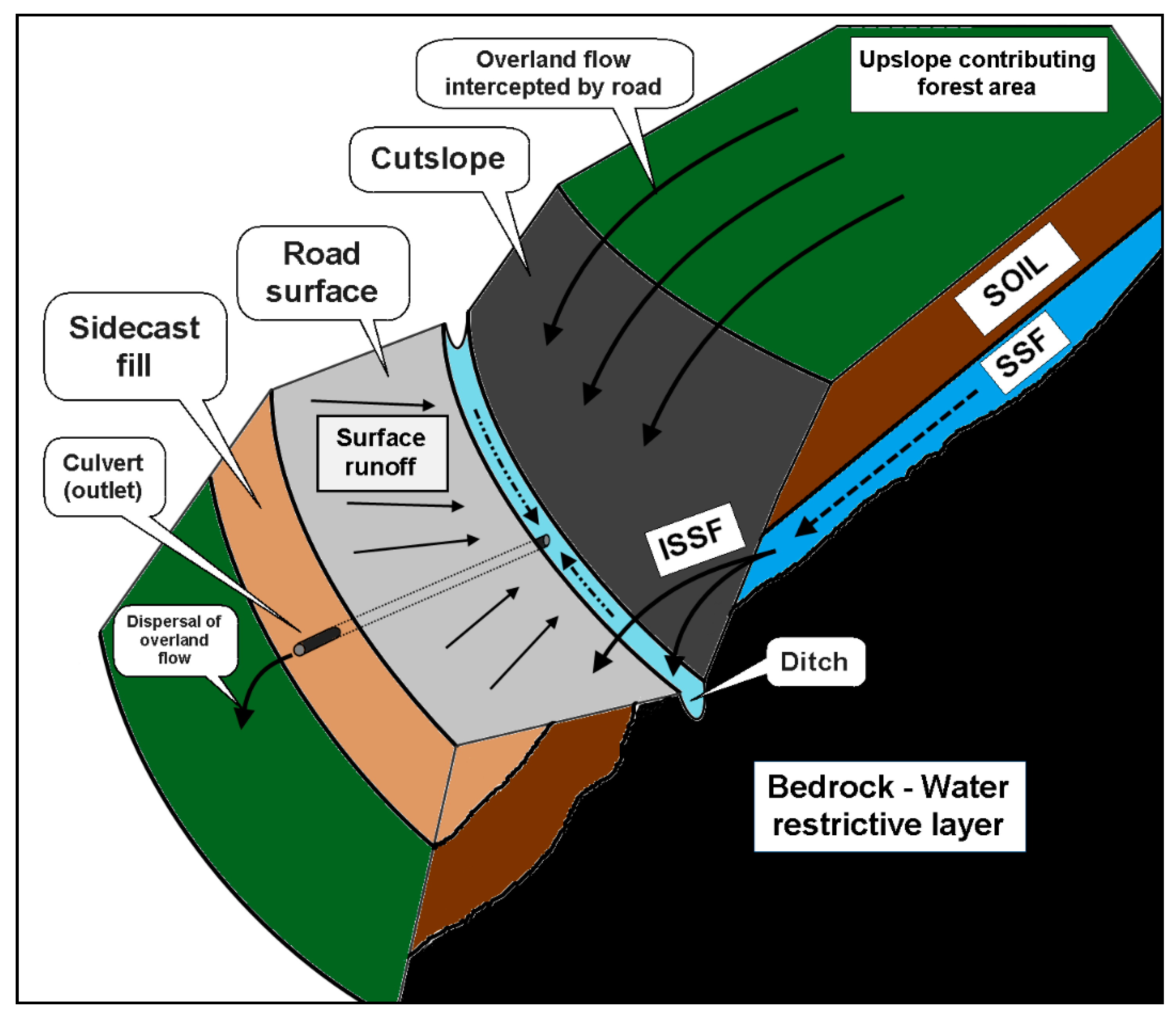
2.2. Interception of Surface and Subsurface Flow from the Road Cutslopes

Research in small upland forested catchment (H. J. Andrews Experimental Forest in Oregon), showed that the construction of forest roads disrupts the subsurface flow system and intercepted subsurface stormflow is the dominant runoff-generation mechanism, while the water exfiltration from the cutbank could be permanent during the year [61]. Road cutslopes can intercept subsurface stormflow, in cases where the depth of the water table is above the height of the cutslope or where a perched water table tends to form [62]. The interception of subsurface stormflow usually occurs when the rainfall exceeds 25–50 mm, under wet antecedent conditions [63]. In some studies, the interception of subsurface stormflow could be more than 79% of the total road overland flow [10,14,64], and in other studies only 4%–8% of the total precipitation was intercepted by the road cutslopes. These differences could be attributed to soil depth, type of geological substrate, land uses, geomorphology, cutslope length and depth, upslope contributing area and other factors, Furthermore, the climate, the annual number and intensity of storm events and the annual precipitation could explain why the subsurface flow is more intense in different studies. However, intercepted subsurface stormflow is probably the major contributor of overland flow in dry tropical climates [31].
It is highlighted that subsurface flow interception alone could significantly change the streamflow in tributary streams during storm events, even in cases that the produced road surface runoff is negligible [58]. Additionally, the increase road runoff by the interception of subsurface flow is highly dependent on upslope contributing area land uses and management [31,51]. In addition, in steep mountainous catchments with high intensity storm events and snow cover, the hillslope length, soil depth, and cutbank depth could elucidate the variability of road runoff among different subcatchments and storm events [10]. During the snowmelt season, the subsurface flow rates are high, mainly because of the saturated soil conditions, which result in increased intercepted subsurface flow from roadcuts, followed by faster stream respond and larger peak flows [11,65]
Field observations in different watershed conditions revealed that during intense storm events, the intercepted subsurface flow significantly affects the catchment hydrograph, reducing the time of peak and increasing the peak flow, while the contribution of the road surface runoff is minor [10,51]. The increased intercepted subsurface flow during intense rainfall events may increase the sediment production and transportation, creating adverse soil conditions for the recovery of vegetation, which in turn exacerbated the surface road runoff [64]. The response of intercepted subsurface flow, especially under increased precipitation values, is highly dependent on hydrologic and geomorphic factors. Antecedent moisture conditions, total precipitation, rainfall history, soil hydraulic conductivity, influence of convergent topography, slope inclination and slope length constitute factors that highly influence the subsurface interception [64,66]. In general, it has been proven that the intercepted subsurface flow could contribute 10%–30% of the total flood discharge in mountainous areas [66].
In steep, forested landscapes with intense storm events, most of the road surface runoff could be generated by subsurface flow interception, which can be routed directly into the streams (via ditches, rills, pipes, culverts), influencing the watershed flood hydrograph. Factors such as hillslope length, cutslope depth, and soil depth explain the variability of hydrologic response among subcatchments and storm events [10]. The physically based Integrated Hydrology Model (InHM) was used to apply 3D and 2D hydrologic response simulations in steep, forested landscape. The results from the 3D simulations reveal that in saturated conditions, the changes in simulated watershed response during and between storms events are significant. Horton overland flow occurs on the road, but subsurface stormflow is the main hydrologic response mechanism that produces most of the overland flow [61].
According to the literature, road cutslopes present the highest values of runoff coefficient, followed by the roadbed and sidecast fill. These studies showed that the runoff coefficient at cutslopes ranged between 58% and 85.9% and overland flow was generated after 1–3 min, the roadbed runoff coefficient ranged between 20% and 51% and overland flow was generated after 25–89 s, and the sidecast fill runoff coefficient ranged between 27% and 58.6% and overland flow was generated after 48–108 s [37,44,67]. Statistical analysis showed that the most important factors that influence runoff generation from cutslopes, roadbed and sidecast fill are the plant cover, followed by rock fragment proportion, organic matter and slope [37,44,67]. As mentioned above, most studies indicate that plant cover seems to be the most important factor that reduces the runoff generation from cutslopes, roadbed and sidecast fill. However, Jordán-López et al. [44] concluded that organic matter is more statistically significant in reducing the runoff generation in roadbed and sidecast fill rather than in cutslope. In addition, they indicated that rock fragments could be as important as plant cover, since rock fragments can enhance water infiltration rate and significantly reduce the runoff generation. However, Ziegler et al. [62] indicated that 12 months of field measurements failed to observe soil moisture changes that could be attributed to intercepted subsurface flow from road cutslopes. Their findings suggest that in the examined tropical study area, the primary source of generated runoff during typical rainfall events is the road surface and not the intercepted subsurface flow from cutslopes.
Surface and subsurface flow intercepted by cutslopes could be the main contributor of overland flow and significantly affect the total flow, peak discharge and sediment delivery in streams during storm events. The construction of forest roads should follow the topography of the area, avoiding steep slopes in order to minimize the cutslope length and, consequently, minimize the area of surface and subsurface flow generation. Immediately after the road construction, revegetation works should be implemented to avoid the loss of the soil, which leads to the permanent degradation of cutslopes [68]. The degradation of road cutslopes makes the future revegetation difficult, resulting in the cutslope surface runoff increase. Surface and subsurface flow from cutslopes should be diverted through culverts and ditches and dispersed in the vegetated forest area below the road location, in order for the infiltrated water amount to be increased and the direct road–stream connectivity to be decreased.

2.3. Connectivity between Forest Roads and Streams

The transportation of road runoff and sediment depends on the hydrologic connectivity, where connectivity is defined as the linkage between runoff locations and the receiving waters [13]. Understanding the road-stream hydrologic connectivity is essential to reduce the amount of surface and intercepted subsurface flow that concludes in streams and influences the quality of downstream aquatic habitats. When overland flow is redirected directly into the streams, it may induce an increase in stream discharge, because of the increase in the total contributing area [58]. Unpaved roads and skid trails could be considered to be the main hydrological active areas in a managed forest ecosystem during low and moderate rainfall events, while the effects of forest roads on runoff and sediment transportation could be better determined by the connectivity of flow paths.
It has been observed that the main type of road-to-stream connectivity was the direct connectivity between roads and streams via gully formation at the outlet of road culverts, and it was revealed that the formation of gullies has increased the catchment drainage density by about 6%–10% during the last few decades [69]. Forest roads are connected with streams via ditches, gullies, pipes and culverts. Direct connectivity appears when there is an evidence of erosion and overland flow from the culvert outlet to the stream channel [51]. Field observations from two small Western Washington catchments at Hard and Ware Creeks revealed that 45%–57% of culverts in the study area were directly connected to the drainage network, and this connectivity can increase the mean annual flood rates by 11%–12% [51]. Variations in hydrologic behavior among segments of the same road network could be attributed to the different distances among the road segments and the hydrologic flow paths. The research results show that the runoff generation on forest roads is influenced by the storm condition and mappable characteristics of the subcatchments and suggest that road runoff may influence the shape (time, runoff volume) of hydrographs at the catchment scale [10,70,71,72].
Although, in a small headwater catchment in peninsular Malaysia, only 21% of the soil erosion was directly attributed to skid trails, and during storm events the recently constructed skid trails exacerbated connectivity with streams by routing the runoff on the logging roads, making the transportation of sediments in the streams easier [73]. Unlike harvested forests, results from more agricultural watersheds showed that 94% of road ditches were directly connected to natural streams, the total water flow and peak discharge were increased by 57% and 78%, respectively, and the high connectivity of road ditches was responsible for the increased transportation of pollutants into the streams [74]. It seems that in watersheds with more agricultural land cover, the influence of unpaved roads is more intense, despite the presence of moderate and low slopes. It is worth mentioning that comparisons of lag time between roaded and unroaded catchments during storm events revealed that in roaded catchments, the lag time was negligible, while in unroaded catchments it was 0–4 h [17]. In the same study, the authors indicated that even in very wet moisture conditions, the roaded catchment produced 42% higher water discharge than the unroaded catchment, proving that roads could facilitate water routing even in hydrological active flow paths.
In mountainous, recently burned coniferous forest areas, the road–stream connectivity was dramatically increased, mainly because of the increased upslope runoff, the limited infiltration rates and the reduced trapping efficiency of the burned slopes [46].
In dry tropical climates, ephemeral streams in unroaded watersheds connect and deliver water flow to the coastline approximately 4 times per year, while in roaded watersheds, the connectivity is significantly increased by 10–13 times each year, which means that road–stream connectivity is a crucial factor that influences the aquatic habitats balance [75]. Stream–road crossings, maximum downslope reach below a road drain, the distance between road segments and streams, the annual precipitation and the number of annual storm events are the main control factors of road–stream connectivity [75].
Taking into consideration the above discussion, it is clear that limiting the connectivity between road runoff and stream networks is very important for the reduction in runoff and sediment delivery, while connectivity prevention measures should be taken during the construction of forest roads. Studies showed that when the surface and intercepted subsurface flow was routed via ditches and pipes for dispersal on the fillslope just below the forest road, the amount of runoff and sediment flow was found to be significantly decreased [58,76,77,78]. The dispersal of road overland flow on non-eroding fillslopes creates favorable conditions for increased water infiltration, sediment detention, and gully prevention, and enables bioturbation action, which significantly restores the antecedent plumes porosity [76,77,78]. An interesting finding of a study conducted at Pang Khum Experimental Watershed in northern Thailand is that the presence of a natural riparian buffer along the banks of streams interrupts the direct connectivity between roads and streams and was proved to reduce the sediment concentration by 34% to 87% during storm events, depending on the magnitude of these events [79].

3. Conclusions, Management Implications, and Future Research

In the near future, it is expected that traffic intensity in forest roads will increase due to the increased human intervention (recreation, logging etc.) in forest ecosystems. The traffic pressure on the forest road network can influence the maintenance rates, which is required to keep the road network efficiently working.
The first management priority, in order to minimize the impact of forest roads on overland flow, is the significant reduction in the surface runoff and overland flow velocity, achieving the reduction in runoff energy and its capability to detach soil particles and transport them into streams [80]. Forest managers need to limit the disturbances of forest roads in logging areas, in order to reduce soil erosion [38]. Additionally, it is very important to reduce the connectivity between the forest roads (or skid trails) and streams, aiming to minimize sediment transportation into the streams.
Most studies indicate the extremely positive role of any type of vegetation land cover or organic matter in the road prism, including naturally/technically established plant buffers, which significantly reduce the runoff generation, sediment production and transportation. The use of bioengineering design of forest roads, which best fits in the different climate and soil conditions, is proposed for the enhanced soil protection and runoff reduction [81,82].
From a construction point of view, the decrease in short- and long-term forest road-related impacts could be achieved by reducing the road cutslope area (minimizing the depth of excavations), the use of light machinery (compaction limiting technology) during forest works and the design road network should be more efficient avoiding hydrologically active zero-order basins. In addition, particularly significant are the techniques that minimize the length and connectivity among skid trails, unpaved roads and streams. Broad-based dips used for runoff control, immediate revegetation of road surfaces, and outsloping of the road base in order to enhance the dispersal of surface runoff on the fillslope are practices that should be incorporated in the planning and designing of forest road networks.
Recently, it was revealed that field observations related to road runoff and sediment generation at a watershed scale provided more accurate information related to these processes in comparison to road erosion models alone [83]. The findings of recent research indicate that there are uncertainties concerning the effects of forest roads on hydrological processes at the watershed scale. Future studies should focus on field measurements, establishing paired watersheds, which would provide a better understanding of the interaction among forest road networks, hydrological processes and the degree of connectivity. The research methodology should bring into focus forest roads’ effects on hydrological processes, especially during intense rainfall events, which have been proven to exacerbate the runoff, sediment generation and delivery into the stream networks.

Funding

This research received no external funding.

Conflicts of Interest

The author declares no conflict of interest.

References

  1. Sidle, R.C.; Ziegler, A.D. The dilemma of mountain roads. Nat. Geosci. 2012, 5, 437–438. [Google Scholar] [CrossRef]
  2. Laurance, W.F.; Sayer, J.; Cassman, K.G. Agricultural expansion and its impacts on tropical nature. Trends Ecol. Evol. 2014, 29, 107–116. [Google Scholar] [CrossRef] [PubMed]
  3. Soulis, K.X.; Dercas, N.; Papadaki, C.H. Effects of forest roads on the hydrological response of a small-scale mountain watershed in Greece. Hydrol. Process. 2015, 29, 1772–1782. [Google Scholar] [CrossRef]
  4. Luce, C.H.; Cundy, T.W. Parameter identification for a runoff model for forest roads. Water Resour. Res. 1994, 30, 1057–1069. [Google Scholar] [CrossRef]
  5. Luce, C.H. Effectiveness of road ripping in restoring infiltration capacity of forest roads. Restor. Ecol. 1997, 5, 265–270. [Google Scholar] [CrossRef]
  6. Ziegler, A.D.; Giambelluca, T.W. Importance of rural roads as source areas for runoff in mountainous areas of northern Thailand. J. Hydrol. 1997, 196, 204–229. [Google Scholar] [CrossRef]
  7. Thomas, R.B.; Megahan, W.F. Peak flow responses to clear-cutting and roads in small and large basins, western cascades, Oregon: A second opinion. Water Resour. Res. 1998, 34, 3393–3403. [Google Scholar] [CrossRef] [Green Version]
  8. Megahan, W.F.; Clayton, J.L. Tracing subsurface flow on roadcuts on steep, forested slopes. Soil Sci. Soc. Am. J. 1983, 47, 1063–1067. [Google Scholar] [CrossRef]
  9. Jones, J.A.; Grant, G.E. Peak flow responses to clearcutting and roads in small and large basins, Western Cascades, Oregon. Water Resour. Res. 1996, 32, 959–974. [Google Scholar] [CrossRef]
  10. Wemple, B.C.; Jones, J.A. Runoff production on forest roads in a steep, mountain catchment. Water Resour. Res. 2003, 39, SWC81–SWC817. [Google Scholar] [CrossRef] [Green Version]
  11. King, J.G.; Tennyson, L.C. Alteration of streamflow characteristics following road construction in north-central Idaho. Water Resour. Res. 1984, 20, 1159–1163. [Google Scholar] [CrossRef]
  12. Wemple, B.C.; Jones, J.A.; Grant, G.E. Channel network extension by logging roads in two basins, western Cascades, Oregon. Water Resour. Bull. 1996, 32, 1195–1207. [Google Scholar] [CrossRef]
  13. Croke, J.; Mockler, S. Gully initiation and road-to-stream linkage in a forested catchment southeastern Australia. Earth Surf. Process. Landf. 2001, 26, 205–217. [Google Scholar] [CrossRef]
  14. La Marche, J.L.; Lettenmaier, D.P. Effects of forest roads on flood flows in the Deschutes River, Washington. Earth Surf. Process. Landf. 2001, 26, 115–134. [Google Scholar] [CrossRef]
  15. Montgomery, D.R. Road surface drainage, channel initiation, and slope instability. Water Resour. Res. 1994, 30, 1925–1932. [Google Scholar] [CrossRef]
  16. Luce, C.H. Hydrological processes and pathways affected by forest roads: What do we still need to learn? Hydrol. Process. 2002, 16, 2901–2904. [Google Scholar] [CrossRef]
  17. Woldie, D.W.; Sidle, R.C.; Gomi, T. Impact of road-generated storm runoff on a small catchment response. Hydrol. Process. 2009, 23, 3631–3638. [Google Scholar] [CrossRef]
  18. Wemple, B.; Browning, T.; Ziegler, A.D.; Celi, J.E.; Chun, K.P.; Jaramillo, F.; Leite, N.K.; Ramchunder, S.J.; Negishi, J.N.; Palomeque, X.; et al. Ecohydrological disturbances associated with roads: Current knowledge, research needs, and management concerns with reference to the tropics. Ecohydrology 2018, 11, e1881. [Google Scholar] [CrossRef]
  19. Harden, C.P. Incorporating roads and footpaths in watershed-scale hydrologic and soil erosion models. Phys. Geogr. 1992, 13, 368–385. [Google Scholar] [CrossRef]
  20. Ramos-Scharrón, C.E.; Figueroa-Sánchez, Y. Plot-, farm-, and watershed-scale effects of coffee cultivation in runoff and sediment production in western Puerto Rico. J. Environ. Manag. 2017, 202, 126–136. [Google Scholar] [CrossRef]
  21. Rijsdijk, A.; Sampurno-Bruijnzeel, L.A.; Sutoto, C.K. Runoff and sediment yield from rural roads, trails and settlements in the upper Konto catchment, East Java, Indonesia. Geomorphology 2007, 87, 28–37. [Google Scholar] [CrossRef]
  22. Kastridis, A.; Stathis, D. Evaluation of hydrological and hydraulic models applied in typical Mediterranean Ungauged watersheds using post-flash-flood measurements. J. Hydrol. 2020, 7, 12. [Google Scholar] [CrossRef] [Green Version]
  23. United States Department of Agriculture Forest Service (USDA). Forest Service 2001. Forest Roads: A Synthesis of Scientific Information; Gucinski, H., Furniss, M.J., Ziemer, R.R., Brookes, M.H., Eds.; General Technical Report PNW-GTR-509; United States Department of Agriculture Forest Service (USDA): Washington, DC, USA, 2004.
  24. Sapountzis, M.; Stathis, D. Relationship between Rainfall and Run-off in the Stratoni Region (N. Greece) after the storm of 10th February 2010. Glob. NEST J. 2014, 16, 420–431. [Google Scholar] [CrossRef]
  25. Kastridis, A.; Stathis, D. Natural and anthropogenic flash flood generation in mountainous watersheds—The case of Apollonia torrent. In Proceedings of the Protection and Restoration of the Environment XI, Thessaloniki, Greece, 3–6 July 2012; Water Resources Management: Thessaloniki, Greece, 2012; pp. 126–135. [Google Scholar]
  26. Kastridis, A.; Kirkenidis, C.; Sapountzis, M. An integrated approach of flash flood analysis in ungauged Mediterranean watersheds using post-flood surveys and unmanned aerial vehicles. Hydrol. Process. 2020, 1–20. [Google Scholar] [CrossRef]
  27. Cuo, L.; Giambelluca, T.W.; Ziegler, A.D.; Nullet, M.A. The roles of roads and agricultural land use in altering hydrological processes in Nam Mae rim watershed, northern Thailand. Hydrol. Process. 2008, 22, 4339–4354. [Google Scholar] [CrossRef]
  28. Reid, L.M.; Dunne, T. Sediment production from forest road surfaces. Water Resour. Res. 1984, 20, 1753–1761. [Google Scholar] [CrossRef] [Green Version]
  29. Loague, K.; Kyriakidis, P.C. Spatial and temporal variability in the R-5 infiltration data set: Déjà vu and rainfall-runoff simulations. Water Resour. Res. 1997, 33, 2883–2895. [Google Scholar] [CrossRef]
  30. MacDonald, L.H.; Coe, D.B.R. Road sediment production and delivery: Processes and management. In Proceedings of the First World Landslide Forum, United Nations University, Tokyo, Japan, 18–21 November 2008; pp. 710–713. [Google Scholar]
  31. MacDonald, L.H.; Sampson, R.W.; Anderson, D.M. Runoff and road erosion at the plot and road segment scales, St John, US Virgin Islands. Earth Surf. Process. Landf. 2001, 26, 251–272. [Google Scholar] [CrossRef]
  32. Ramos-Scharrón, C.E.; MacDonald, L.H. Runoff and suspended sediment yields from an unpaved road segment, St John, US Virgin Islands. Hydrol. Process. 2007, 21, 35–50. [Google Scholar] [CrossRef]
  33. Ramos-Scharrón, C.E.; LaFevor, M.C. The role of unpaved roads as active source areas of precipitation excess in small watersheds drained by ephemeral streams in the Northeastern Caribbean. J. Hydrol. 2016, 533, 168–179. [Google Scholar] [CrossRef]
  34. Forsyth, A.R.; Bubb, K.A.; Cox, M.E. Runoff, sediment loss and water quality from forest roads in a southeast Queensland coastal plain Pinus plantation. For. Ecol. Manag. 2006, 221, 194–206. [Google Scholar] [CrossRef]
  35. Butzen, V.; Seeger, M.; Wirtz, S.; Huemann, M.; Mueller, C.; Casper, M.; Ries, J.B. Quantification of Hortonian overland flow generation and soil erosion in a Central European low mountain range using rainfall experiments. Catena 2014, 113, 202–212. [Google Scholar] [CrossRef]
  36. Zemke, J.J. Runoff and soil erosion assessment on forest roads using a small scale rainfall simulator. J. Hydrol. 2016, 3, 25. [Google Scholar] [CrossRef] [Green Version]
  37. Arnáez, J.; Larrea, V.; Ortigosa, L. Surface runoff and soil erosion on unpaved forest roads from rainfall simulation tests in northeastern Spain. Catena 2004, 57, 1–14. [Google Scholar] [CrossRef]
  38. Hartanto, H.; Prabhu, R.; Widayat, A.S.E.; Asdak, C. Factors affecting runoff and soil erosion: Plot-level soil loss monitoring for assessing sustainability of forest management. For. Ecol. Manag. 2003, 180, 361–374. [Google Scholar] [CrossRef]
  39. Heede, B.-H.; King, R.-M. State-of-the-art timber harvest in an Arizona mixed conifer forest has minimal effect on overland flow and erosion/L’exploitation rationelle du bois d’oeuvre dans une forêt mixte de conifères a un effet minimal sur l’écoulement de surface et l’érosion. Hydrol. Sci. J. 1990, 35, 623. [Google Scholar] [CrossRef]
  40. Robichaud, P.R.; Foltz, R.B.; Luce, C.H. Development of an on-site prediction model for forest roads and timber harvest areas. In Sediment Problems: Strategies for Monitoring, Prediction and Control (Proceedings of the Yokohama Symposium, July 1993); Hadley, R.F., Mizuyama, T., Eds.; IAHS Publ. No. 217; International Association of Hydrological Sciences Publication: Wallingford, UK, 1993; pp. 135–140. [Google Scholar]
  41. Eastaugh, C.S.; Rustomji, P.K.; Hairsine, P.B. Quantifying the altered hydrologic connectivity of forest roads resulting fromdecommissioning and relocation. Hydrol. Process. 2008, 22, 2438–2448. [Google Scholar] [CrossRef]
  42. Robichaud, P.R.; Wagenbrenner, J.W.; Brown, R.E. Rill erosion in natural and disturbed forests: 1. Measurements. Water Resour. Res. 2010, 46, 14. [Google Scholar] [CrossRef]
  43. Wagenbrenner, J.W.; Robichaud, P.R.; Elliot, W.J. Rill erosion in natural and disturbed forests: 2. Modeling approaches. Water Resour. Res. 2010, 46, 14. [Google Scholar] [CrossRef] [Green Version]
  44. Jordán-López, A.; Martínez-Zavala, L.; Bellinfante, N. Impact of different parts of unpaved forest roads on runoff and sediment yield in a Mediterranean area. Sci. Total Environ. 2009, 407, 937–944. [Google Scholar] [CrossRef]
  45. Tmomaz, E.L.; Ramos-Scharrón, C.E. Rill length and plot-scale effects on the hydrogeomorphologic response of gravelly roadbeds. Earth Surf. Process. Landf. 2015, 40, 2041–2048. [Google Scholar] [CrossRef]
  46. Sosa-Pérez, G.; MacDonald, L. Wildfire effects on road surface erosion, deposition, and road–stream connectivity. Earth Surf. Process. Landf. 2017, 42, 735–748. [Google Scholar] [CrossRef]
  47. Foltz, R.B.; Copeland, N.S.; Elliot, W.J. Reopening abandoned forest roads in northern Idaho, USA: Quantification of runoff, sediment concentration, infiltration, and interrill erosion parameters, 2009. J. Environ. Manag. 2009, 90, 2542–2550. [Google Scholar] [CrossRef] [PubMed]
  48. Foltz, R.B.; Burroughs, E.R., Jr. Sediment production from forest roads and wheel ruts. In Proceedings of the Watershed Planning and Analysis in Action, Durango, CO, USA, 9–11 July 1990; American Society of Civil Engineers: New York, NY, USA, 1990; pp. 266–275. [Google Scholar]
  49. Sheridan, G.J.; Noske, P.J.; Lane, P.N.J.; Sherwin, C.B. Using rainfall simulation and site measurements to predict annual interrill erodibility and phosphorus generation rates from unsealed forest roads: Validation against in-situ erosion measurements. Catena 2008, 73, 49–62. [Google Scholar] [CrossRef]
  50. Tague, C.; Band, L. Simulating the impact of road construction and forest harvesting on hydrologic response. Earth Surf. Process. Landf. 2001, 26, 135–151. [Google Scholar] [CrossRef]
  51. Bowling, L.C.; Lettenmaier, D.P. The effects of forest roads and harvest on catchment hydrology in a mountainous maritime environment. In Land Use and Watersheds: Human Influence on Hydrology and Geomorphology in Urban and Forest Areas; Wigmosta, M.S., Burges, S.J., Eds.; American Geophysical Union: Washington, DC, USA, 2001. [Google Scholar] [CrossRef]
  52. Bowling, L.C.; Lettenmaier, D.P. Evaluation of the Effects of Forest Roads on Streamflow in Hard and Ware Creeks, Washington; Water Resources Series Technical Report No. 155; University of Washington: Seattle, WA, USA, 1997; Volume 155, 202p, Available online: https://www.ce.washington.edu/sites/cee/files/pdfs/research/hydrology/water-resources/WRS155.pdf (accessed on 12 September 2020).
  53. Hawbaker, T.J.; Radeloff, V.C.; Hammer, R.B.; Clayton, M.K. Road density and landscape pattern in relation to housing density, land ownership, land cover, and soils. Landsc. Ecol. 2005, 20, 609–625. [Google Scholar] [CrossRef]
  54. USDA Forest Service. National Forest System Road Management Strategy; USDA Forest Service: Washington, DC, USA, 2001; 163p.
  55. Dymond, S.F.; Aust, W.M.; Prisley, S.P.; Eisenbies, M.H.; Vose, J.M. Application of a distributed process-based hydrologic model to estimate the effects of forest road density on stormflows in the Southern Appalachians. For. Sci. 2014, 60, 1213–1223. [Google Scholar] [CrossRef] [Green Version]
  56. Cuo, L.; Giambelluca, T.W.; Ziegler, A.D.; Nullet, M.A. Use of the distributed hydrology soil vegetation model to study road effects on hydrological processes in Pang Khum Experimental Watershed, northern Thailand. For. Ecol. Manag. 2006, 224, 81–94. [Google Scholar] [CrossRef]
  57. Ziegler, A.D.; Negishi, J.N.; Sidle, R.C.; Gomi, T.; Noguchi, S.; Nik, A.R. Persistence of road runoff generation in a logged catchment in Peninsular Malaysia. Earth Surf. Process. Landf. 2007, 32, 1947–1970. [Google Scholar] [CrossRef]
  58. Wigmosta, M.S.; Perkins, W.A. Simulating the effects of forest roads on watershed hydrology. In Land Use and Watersheds: Human Influence on Hydrology and Geomorphology in Urban and Forest Areas; American Geophysical Union: Washington, DC, USA, 2001. [Google Scholar] [CrossRef]
  59. Lane, P.N.J.; Sheridan, G.J. Impact of an unsealed forest road stream crossing: Water quality and sediment sources. Hydrol. Process. 2002, 16, 2599–2612. [Google Scholar] [CrossRef]
  60. Dutton, A.L.; Loague, K.; Wemple, B.C. Simulated effect of a forest road on near-surface hydrologic response and slope stability. Earth Surf. Process. Landf. 2005, 30, 325–338. [Google Scholar] [CrossRef]
  61. Mirus, B.B.; Ebel, B.A.; Loague, K.; Wemple, B.C. Simulated effect of a forest road on near-surface hydrologic response: Redux. Earth Surf. Process. Landf. 2007, 32, 126–142. [Google Scholar] [CrossRef]
  62. Ziegler, A.D.; Giambelluca, T.W.; Sutherland, R.A.; Vana, T.T.; Nullet, M.A. Horton overland flow contribution to runoff on unpaved mountain roads: A case study in northern Thailand. Hydrol. Process. 2001, 15, 3203–3208. [Google Scholar] [CrossRef]
  63. Weiler, M.; McDonnell, J.J.; Tromp-van Meerveld, H.J.; Uchida, T. Subsurface stormflow. In Encyclopedia of Hydrological Sciences; Anderson, M.G., Ed.; Wiley and Sons: New York, NY, USA, 2005; pp. 1719–1732. [Google Scholar] [CrossRef]
  64. Negishi, J.N.; Sidle, R.C.; Ziegler, A.D.; Noguchi, S.; Rahim, N.A. Contribution of intercepted subsurface flow to road runoff and sediment transport in a logging-disturbed tropical catchment. Earth Surf. Process. Landf. 2008, 33, 1174–1191. [Google Scholar] [CrossRef]
  65. Megahan, W.F. Hydrologic effects of clearcutting and wildfire on steep granitic slopes in Idaho. Water Resour. Res. 1983, 19, 811–819. [Google Scholar] [CrossRef]
  66. Orfánus, T.; Jenčo, M.; Bebej, J.; Benko, M. Simulation of the effects of forest roads on stormflow generation using GIS and 2D vadose zone hydrological model. Ekológia (Bratislava) 2017, 36, 25–39. [Google Scholar] [CrossRef] [Green Version]
  67. Jordán, A.; Martínez-Zavala, L. Soil loss and runoff rates on unpaved forest roads in southern Spain after simulated rainfall. For. Ecol. Manag. 2008, 255, 913–919. [Google Scholar] [CrossRef]
  68. Benda, L.; James, C.; Miller, D.; Andras, K. Road Erosion and Delivery Index (READI): A model for evaluating unpaved road erosion and stream sediment delivery. J. Am. Water Resour. Assoc. 2019, 55, 459–484. [Google Scholar] [CrossRef]
  69. Croke, J.; Mockler, S.; Fogarty, P.; Takken, I. Sediment concentration changes in runoff pathways from a forest road network and the resultant spatial pattern of catchment connectivity. Geomorphology 2005, 68, 257–268. [Google Scholar] [CrossRef]
  70. Wemple, B.C.; Swanson, F.J.; Jones, J.A. Forest roads and geomorphic process interactions, Cascade Range, Oregon. Earth Surf. Process. Landf. 2001, 26, 191–204. [Google Scholar] [CrossRef]
  71. Thomaz, E.; Peretto, G. Hydrogeomorphic connectivity on roads crossing in rural headwaters and its effect on stream dynamics. Sci. Total Environ. 2016, 550, 547–555. [Google Scholar] [CrossRef] [PubMed]
  72. Grace, J.M., III. Predicting forest road surface erosion and storm runoff from high-elevation sites. ASABE 2017, 60, 705–719. [Google Scholar] [CrossRef]
  73. Sidle, R.C.; Sasaki, S.; Otsuki, M.; Noguchi, S.; Rahim, N.A. Sediment pathways in a tropical forest: Effects of logging roads and skid trails. Hydrol. Process. 2004, 18, 703–720. [Google Scholar] [CrossRef]
  74. Buchanan, B.P.; Falbo, K.; Schneider, R.L.; Easton, Z.M.; Walter, M.T. Hydrological impact of roadside ditches in an agricultural watershed in Central New York: Implications for non-point source pollutant transport. Hydrol. Process. 2013, 27, 2422–2437. [Google Scholar] [CrossRef]
  75. Ramos-Scharrón, C.E.; LaFevor, M.C. Effects of forest roads on runoff initiation in low-order ephemeral streams. Water Resour. Res. 2018, 54, 8613–8631. [Google Scholar] [CrossRef]
  76. Hairsine, P.B.; Croke, J.C.; Mathews, H.; Fogarty, P.; Mockler, S.P. Modelling plumes of overland flow from logging tracks. Hydrol. Process 2002, 16, 2311–2327. [Google Scholar] [CrossRef]
  77. Lane, P.N.J.; Hairsine, P.B.; Croke, J.C.; Takken, I. Quantifying diffuse pathways for overland flow between the roads and streams of the mountain ash forests of central Victoria Australia. Hydrol. Process. 2006, 20, 1875–1884. [Google Scholar] [CrossRef]
  78. Takken, I.; Croke, J.; Lane, P. A methodology to assess the delivery of road runoff in forestry environments. Hydrol. Process. 2008, 22, 254–264. [Google Scholar] [CrossRef]
  79. Ziegler, A.D.; Negishi, J.; Sidle, R.C.; Preechapanya, P.; Sutherland, R.A.; Giambelluca, T.W.; Jaiaree, S. Reduction of stream sediment concentration by a riparian buffer: filtering of road runoff in disturbed headwater basins of Montane Mainland Southeast Asia. J. Environ. Qual. 2006, 35, 151–162. [Google Scholar] [CrossRef]
  80. Grace, J.M., III; Clinton, B.D. Protecting soil and water in forest road management. Trans. ASABE 2007, 50, 1579–1584, USDA Forest Service, UNL Faculty Publications. Available online: https://digitalcommons.unl.edu/usdafsfacpub/58 (accessed on 3 September 2020). [CrossRef] [Green Version]
  81. Grace, J.M., III. Effectiveness of vegetation in erosion control from forest road sideslopes. Trans. ASAE 2002, 45, 681–685. [Google Scholar] [CrossRef] [Green Version]
  82. Lotfalian, M.; Babadi, T.Y.; Akbari, H. Impacts of soil stabilization treatments on reducing soil loss and runoff in cutslope of forest roads in Hyrcanian forests. Catena 2019, 172, 158–162. [Google Scholar] [CrossRef]
  83. Surfleet, C.G.; Skaugset, A.E., III; Meadows, M.W. Road runoff and sediment sampling for determining road sediment yield at the watershed scale. Can. J. For. Res. 2011, 41, 1970–1980. [Google Scholar] [CrossRef]
Figure 1. Schematic representation of forest road cutslope, depicting the overland flow, subsurface flow (SSF) and intercepted subsurface flow (ISSF).
Forests 11 01201 g001
Publisher’s Note: MDPI stays neutral with regard to jurisdictional claims in published maps and institutional affiliations.

