Article

Spatio-Temporal Changes of Urban Forests and Planning Evolution in a Highly Dynamical Urban Area: The Case Study of Wrocław, Poland

by
Justyna Jaworek-Jakubska
1,*,
Maciej Filipiak
1,
Adam Michalski
2 and
Anna Napierała-Filipiak
3
1
Institute of Landscape Architecture, The Faculty of Environmental Engineering and Geodesy, Wrocław University of Environmental and Life Sciences, ul. Grunwaldzka 55, 50-357 Wrocław, Poland
2
Institute of Geodesy and Geoinformatics, The Faculty of Environmental Engineering and Geodesy, Wrocław University of Environmental and Life Sciences, ul. Grunwaldzka 55, 50-357 Wrocław, Poland
3
Institute of Dendrology, Polish Academy of Sciences, Laboratory of Ecology, ul. Parkowa 5, 62-035 Kórnik, Poland
*
Author to whom correspondence should be addressed.
Forests 2020, 11(1), 17; https://doi.org/10.3390/f11010017
Submission received: 28 November 2019 / Revised: 13 December 2019 / Accepted: 17 December 2019 / Published: 20 December 2019
(This article belongs to the Special Issue Urban Forestry and Landscape Restoration)

Abstract

:
Knowledge about urban forests in Poland is still limited, as it is primarily based on aggregate, formal data relating to the general area, ignoring the spatial dimension and informal green areas. This article describes and analyses spatio-temporal changes in the actual urban forest resources in Wrocław in 1944–2017, which covers the first period of the city’s rebuilding after its destruction during World War II and its development during the nationalised, centrally-planned socialist economy, as well as the second period of intensive and only partly controlled growth under conditions of market economy. The study is based on current and historical orthophotomaps, which were confronted with cartographic data, as well as planning documents. We found that between 1944 and 2017, the percentage contribution of informal woodlands increased tenfold (from 0.5 to 4.9% of the present total area of the city). The area occupied by such forests has grown particularly during the most recent years of the city’s intensive development. However, the forests have been increasingly fragmented. During the first period, new forest areas were also created in the immediate vicinity of the city centre, while during the second one, only in its peripheral sections. The post-war plans regarding the urban green spaces (UGS), including the current plan, are very conservative in nature. On the one hand, this means no interference with the oldest, biggest, and most valuable forest complexes, but on the other hand, insufficient consideration of the intensive built-up area expansion on former agriculture areas. Only to a limited extent did the above-mentioned plans take into account the informal woodlands, which provide an opportunity for strengthening the functional connectivity of landscape.

1. Introduction

During the last century, urbanisation processes have accelerated rapidly, as a result of which over half of the global population is currently living in urban areas [1,2], and the rate in Europe is predicted to reach 83% in 2050 [3]. Natural resources, including forests and green areas, are under enormous pressure, and urban quality of life has been on the decrease [4]. A sudden expansion of built-up areas is linked to a reduction in the areas of arable land and forests [5], and with increased fragmentation and discontinuity of green areas [6,7]. Thus, the biggest challenge to municipal authorities and planners is to develop urban structures that are more resilient, sustainable, and liveable [8]. A sizeable contribution to the process can be made by appropriate green area development and management, including urban and peri-urban forest and tree systems [9]. Urban forests that create islands in the fragmented urban environment are the most common natural habitats in urban areas [10]. Although their resources are small when compared with the total forest area in Europe, they offer many benefits and services to society [11,12]. Forests and green areas greatly contribute to the adaptation of urban areas to climate changes, [13,14,15,16,17,18], as well as to the protection of biodiversity [16,19,20]. They also provide economic benefits in the form of increased real property prices [21,22,23,24] and a number of socio-cultural services [16,25,26] essential for the well-being of humans [27]. Forests also improve physical health and mental well-being [28,29,30,31].
Forests have played a key role in urban development, and their management has had a long history in Europe [32]. A major turning point occurred in the 19th century, when as a result of industrialisation and a sudden population growth, the demand for recreational areas rose. The interest in urban forests in Germany, including Silesia, grew significantly in the years 1880–1935, which was a result of a number of factors, e.g., an enormous expansion of cities, the strengthening of the role of urban open spaces in planning concepts, an increased significance of hygiene in cities, the impact of the concept of forest aesthetics, and the idea of home culture (Heimetschutz), on the practices of foresters and landscape architects, as well as the incorporation into German town planning of the North American park system concepts [33]. Today, debates regarding urban development are focused not only on the growth, but also on the decline of cities, especially in the post-industrial regions of the United Kingdom (UK), France, Germany, and, lately, also Eastern Europe [34,35,36,37]. Economic and demographic changes have affected land use intensity and structure [38], as well as changes in the provision of green spaces within European towns and cities [39]. Studies of changes in urban green spaces have indicated regional discrepancies: The cities in Southern Europe are characterised by a poorer accessibility of green areas than that in the cities of Northern, Central, or Western Europe [40]. It has also been noticed that Eastern European cities experienced a decline in urban green spaces (2000–2006), while in Western and Southern Europe, they have been on the rise [41]. Differences have also been noticed in the structure of peri-urban forests in the European metropolitan areas [42]. The negative trends associated with the decrease in green and forest areas in Eastern Europe have been accredited to poor public area planning, which is an effect of the post-1990 urban development based on free-market practices concentrated on private property rights [43,44,45,46]. City centres are experiencing rapid and chaotic commercialisation [47,48], and free spaces are being built up with new commercial structures and housing [49]. At the same time, the outflow of the population from urban areas has accelerated the suburbanisation process, which has assumed a spectacular form in Eastern Europe [43,50,51].
The data regarding forest resources in Polish towns and cities are still limited. No comprehensive urban forest inventory has been conducted to enable a comparison of results at the national or European levels. Forest resources within urban impact are characterised by fragmentation and a complicated ownership structure [52]. The forests in individual towns and cities are regionally differentiated, which is a result of various natural and historical conditions [53,54]. The studies regarding forests and green areas in Poland generally use formal classifications (urban forests, parks, cemeteries, allotment gardens, street greenery) from available European databases (e.g., CORINE Land Cover, Urban Atlas) or national ones (Topographic Object Database BDOT10k and the Central Statistical Office CSO). Analyses based on statistical data overlook the spatial aspect of urban green [55], although urbanisation affects landscape processes and structure, causing land use fragmentation [56]. The official Polish classifications also ignore some less tangible, informal forms of green that arise spontaneously on abandoned land that has not been recognised or designated by public authorities or owners as green areas [55]. Meanwhile, in many countries, during the last 20 years, informal greenery and open spaces (brownfields, vacant lots) have acquired a new dimension, both in developing cities due to a deficit in green areas in city centres and growing green maintenance costs [57,58,59], and in regions in decline, where a fall in the population has led to urban structure disintegration and creation of free spaces in town centres, which offers an opportunity for establishing new green areas [60,61,62,63,64].
Constant monitoring of urban forests is one of the key elements of European policy, which supports planning and sustainable management strategies [42]. Because of ongoing urbanisation, leading to a gradual transformation of natural areas into anthropogenic ones, there exists a need to investigate long-term dynamics and structure of woodlands on a local scale in rapidly developing regions and cities [65,66,67]. Wrocław is regarded as one of the eight major metropolitan areas in Poland.
The goal of this article is to (1) analyse the spatio-temporal changes in urban forests in Wrocław from the completion of the steps related to the creation of a comprehensive urban greenery system (the 1930s), through the city’s reconstruction after World War II (WWII) and its development during the period of centralised socialist economy, until the period of transformation and formation of a modern city in free-market economy (1989–2018); (2) examine the urban development plans of 1924, 1998, and 2018 in terms of formation of urban forest resources and structure, as well as their connection with the city’s green system. The study findings constitute a basis for a discussion of future urban forest strategies in response to contemporary spatial changes within Poland.

2. Materials and Methods

2.1. Study Area

Wrocław is located in south-western Poland, in the central part of Silesian Lowland. Currently, it is one of the major metropolitan centres in Poland—the fourth biggest one in terms of population (635,759 inhabitants) [68] and the fifth biggest one in terms of area (29,282 ha) [69]. The city’s special nature is a result of its complex history related to its location on the Polish–German–Bohemian border (during its over 1000-year-long history, the city has belonged to various state organisms) and its well-developed water system (it lies on the Odra River, at the point where four rivers flow into it: The Bystrzyca, the Oława, the Ślęza, and the Widawa). The land relief within Wrocław is rather monotonous and includes lowland areas in the Odra Valley and some plateaux (Oleśnicka Plain, Średzka Plateau, and Kącka Plain) [70]. The city’s location in Odra Valley in the Sudeten Foreland leads to characteristic climatic conditions. On the one hand, it experiences privileged thermal conditions (the Wrocław–Opole heat area), and on the other hand, the region is poorly aired, which is conducive to the frequent formation of mists and an elevated air humidity [71]. Wrocław’s soils form a mosaic; there are fluvisols in the river valleys, phaeozems in the northern and southern parts of the city, and brown soils in higher locations. Wrocław’s fertile soils, especially on the Odra’s right-hand bank, have been conducive to the development of agriculture, which led to a sizeable shrinkage of the forest areas already in the early Middle Ages [72]. The growing urbanisation, agricultural intensification, and the Odra’s regulation have led to a considerable reduction in primary riparian forests growing in the Odra River valley [73]. Despite this, the percentage of moist habitats—riparian and alder forest—is very high in Wrocław’s urban forests, amounting to 44.6%. Fertile fresh habitats constitute 52%. The most popular habitat types in Polish forests—the coniferous forests—occupy only 1.5% of the total area in Wrocław. The dominant tree species is oak (57%). The average stand age is relatively high, at 71 years [74]. The total forest area amounts to 2,237.2 ha, which translates into the forest cover rate of 7.6%. The forests are owned by: State Forests (56.5%), Wrocław municipality (40.8%), individuals (1.7%), or the Agricultural Property Agency (1.0%). About 26% of the urban forests are located within protected zones.

2.2. Spatial Data and Methods

For the purposes of our analyses, we accepted the city’s area in its current boundaries. The spatio-temporal analysis of urban forests was based on the combined geospatial data, obtained from multiple data sources (Table 1). The first group of materials analysed were aerial photographs (1944), and orthophotomaps (1994 and 2015–2017), which were used to acquire data about the forest cover (including informal woodland areas). The topographic maps (1942 and 1995–1998), cartographic materials Karto10K (2015–2016), and the local spatial information database (SIP) containing official land cover classifications were used to classify objects identified on the aerial photographs and orthophotomaps, indicating formal and informal woodland areas.
The selection of the cartographic materials takes account of two important stages in the development of the city and its green areas: Period I: 1944–1994—reconstruction of the city, 70% of which had been damaged during WWII, and its development in the post-war period in conditions of centralised and mostly nationalised socialist economy; period II: 1994–2017—the city’s transformation and expansion in new socio-economic conditions (market economy, significantly more based on private property).
The forest cover change analysis was based on the retrospective approach, with places emphasis on landscape transformation over time in relation to the present-day landscape [75,76,77,78,79]. In this case study, the reconstruction of the forest cover changes from 2017 to 1944 was based on the geospatial data obtained by vectorisation of the cartographic materials and orthophotomaps, using geographical information systems (GIS). For each time-layer, forest-covered areas (formal and informal), as well as other land cover forms (built-up area, water, urban greenery, other open space), were determined. In accordance with the Forest Act [80], a forest was understood as a land with an area of at least 0.10 ha, covered with forest vegetation.
The analysis of forest transition was carried out in several stages. First, the percentages of the forest areas, as well as the relations between the formal and informal forest areas in the selected years (1944, 1994, 2017), were compared. Afterwards, in order to assess the change in the spatial patterns of the forest, selected landscape indicators at the landscape level were analysed: The number of patches by class (NP), the mean patch size (MPS), and the mean nearest neighbour distance (MNND) [81]. The calculations were made by means of FRAGSTATS 4.1 (University of Massachusetts, Amherst, MA, USA) [82].
The changes in the forest cover were evaluated using the transition matrix [83,84,85,86]. The analysis of the transformation of the initial land cover (1944) into the final one (2017) allowed us to capture the key paths of land cover occurring throughout the investigated period. In order to obtain more detailed information about the dynamic of the forest cover area, the authors performed a spatio-temporal analysis using a choropleth map, constructed in a GIS environment. The appropriately aggregated data in a grid of 500 500 m reference fields enabled us to determine the differences between the last and the first forest covers in each unit in a given time period. As a result, two grid maps provide information of direction (increasing/declining) and a magnitude of change in the successive time-slice.
The goal of the last stage was to determine the role of the forest areas in the city’s present and future spatial policy and the functioning of this land cover form within urban green spaces (UGS). Three master plans for Wrocław have been compared: Wrocław’s first general plan (1924), drawn up by the City Expansion Office under Fritz Behrendt; “Study on the conditions and directions of land development in Wrocław” (1998) [87], drawn up by Wrocław Development Office and Wrocław University of Science and Technology; and “Study on the conditions and directions of land development in Wrocław” (2018) [88], drawn up by Wrocław Development Office. The data for the assessment of changes in the planned greenery systems in the following years were obtained from the local spatial information system (SIP), which contains data for the years 1998 and 2018, as well as the digitised graphic part of the historic plan from 1924.

3. Results

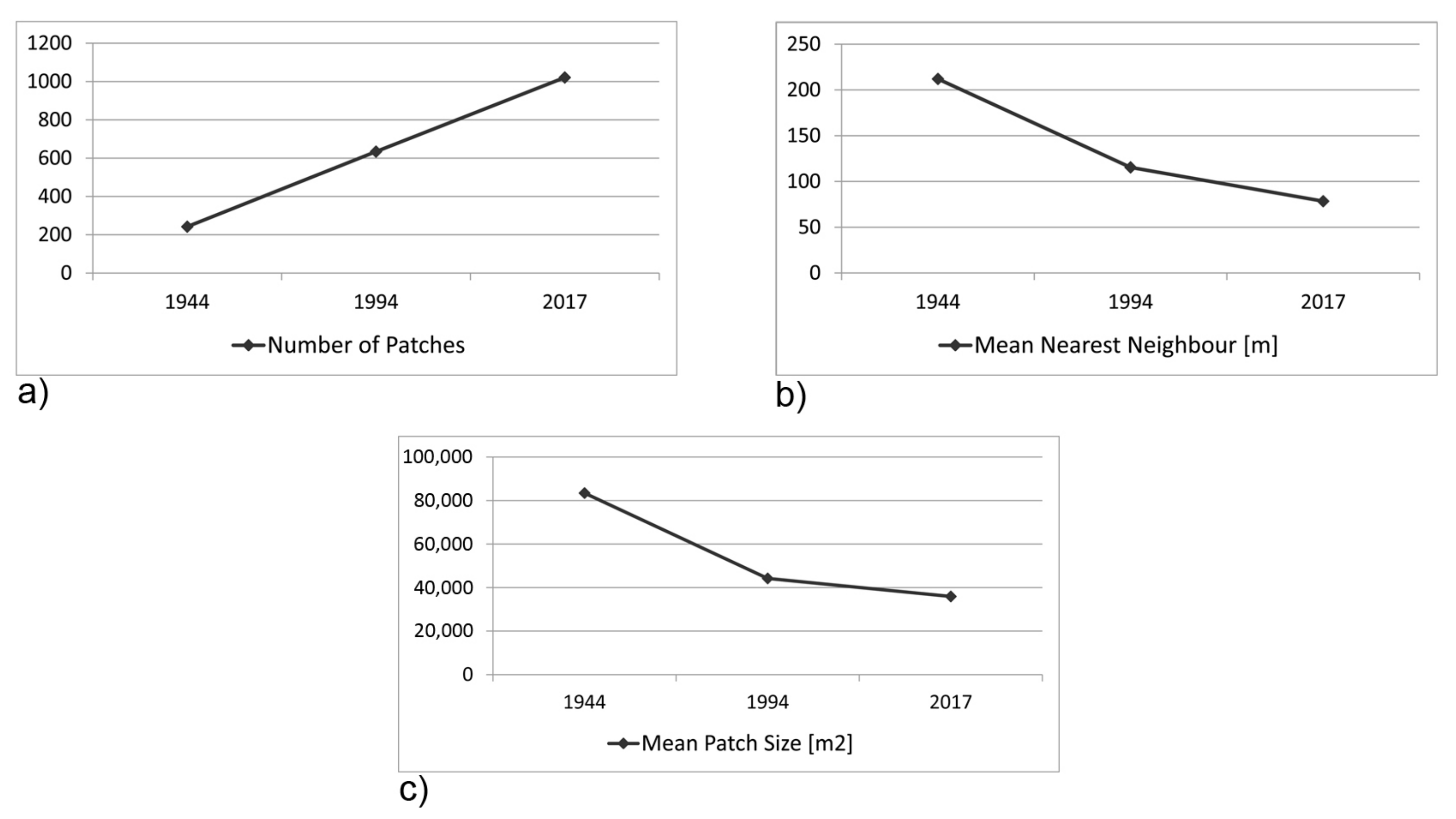
3.1. Forests in the Context of Land Cover Changes (1944–2017)

In 1944, for each 1 ha of built-up area, there was 0.30 ha of the city’s area officially regarded as forest or 0.33 ha if informal woodland is taken into account. In 1994, the corresponding figures amounted to 0.27 ha and 0.38 ha, and in 2016, nearly 0.23 ha and 0.37 ha. This shows that taking into account or not taking into account of informal woodlands has a significant impact on the trend in changes to Wrocław’s tree cover. The annual growth in informal and formal forest area was nearly twice as big during the period of free-market economy (1994–2017) as that during the period of nationalised socialist economy (1944–1994) (Table 2, Figure 1).
Field observations have shown that new informal woodlands are dominated by striped tree communities along rivers and drainage ditches, as well as by small, fragmented forest patches in post-agricultural and wetland areas. The species composition and structure of informal woodlands are varied and depend on the type of habitat, as well as on the phase of natural succession. The trees species, forming neighbouring formal and informal greenery, have a great impact on the species composition of a given spontaneous tree communities.
Potential habitats of alluvial forests have a significant share of willows (Salix sp.) and poplars (Populus sp.), but species characteristic for fertile alluvial forests such as ash (Fraxinus sp.) and pedunculate oaks (Quercus robur L.) are also numerous (Figure S1). Elms, especially European white elm (Ulmus laevis Pall.) and field elm (Ulmus minor Mill.), which are today rare in Poland, can be found quite frequently (Figures S2 and S3). In areas with less moisture (potential habitats of oak–hornbeam forests), especially ones that have undergone significant transformation (former industrial plants, allotment gardens), meadow and ruderal species are replaced by communities with a predominance of native pioneer species—verrucose birch (Betula pendula), aspens (Populus tremula L.), and, in some places, also Scots pine (Pinus sylvestris L.) and European larch (Larix deciduas Mill.) (Figures S4 and S5). Foreign species are mainly represented by black locust (Robinia pseudoacacia L.) and ash-leaved maple (Acer negundo L.), and, to a lesser extent, also by Chinese sumac (Ailanthus altissima (Mill.) Swingle), American bird cherry (Prunus serotina Ehrh.), and feral fruit species, mainly of the genus Prunus L. (plum, apricot) and Pyrus L. (pear). In places, walnut (Juglans regia L.) shows significant rate of natural regeneration from seeds. In some places, post-pioneer species predominate, such as lindens (Tilia cordata Mill.), ashes (Fraxinus. excelsior L.), sycamores (A. pseudoplatanus L.), and, especially common maples (A. platanoides L.), as well as pedunculate and sessile oaks (Q. robur, Quercus petrea (Matt) Liebl.). The above-mentioned black locust (R. pseudoacacia), which in Poland has the status of domesticated anthropophyte, occurs particularly often in the areas of former 19th century forts and in other former military areas (Figure S6).
Development expansion has brought about a discernible reduction in the distance between buildings and forest patches. In 1944, the average distance between forests and buildings amounted to 269 m, by 1994 it dropped to 151 m, and by 2017 to 80 m. Until 1944, small and large forest forms constituted accordingly 91% and 9% of all forest areas. After 1944, the ratio of large and small forest patches was subject to considerable changes: In 1994, large forest complexes constituted 72%, and small forest patches—28% of all forest areas, while by 2017, the percentage of large complexes fell to 61%, and small forest patches rose to 39%. The forest fragmentation process is confirmed by the landscape indicators, which show that in the years 1944–2017, the number of forest patches increased (from 242 to 1021), with a simultaneous decrease in the average patch area (from 83,420 to 3592 m2) and the in distance between them (from 212 to 80 m) (Figure 2).
Analysis of the land cover transition in the entire period under study (Table 3, Figure 3) has indicated that the positive forest area balance is made up both by the establishment of new forests (226 ha) and transformation of the existing forest areas into other land cover forms (1854 ha). New woodlots and forests have been primarily created on open land (86%, 5.5% of the city’s area), and to a lesser extent, on built-up areas (6%), usually on post-industrial land and along railway lines, on land previously occupied by parks (5%), in former workings and filled-up riverbeds (3%). Interestingly enough, more often than not, forest areas transformed into open land 71%, 0.6% of the city’s area), and, less frequently, into built-up areas (12%), green areas (12%), or waters (5%). The longest-lasting forest forms are forest complexes on the city’s outskirts, which constitute nearly half of all forests.
Analysis of forest dynamics in the basic field grid (Figure 4) in the years 1944–1994 has indicated an increase in forest areas in 515 fields (mainly in the range of 0.01–2.00 ha), no change in 473 fields, and a decrease in 130 fields. During the second period, the predominant trend has been no change (566 fields), with an increase recorded in 459 fields (mainly in the range of 0.01–2.00 ha), and a decrease in 93 fields. In the first period (1942–1994), the changes occurred both in the city centre and on its fringe. During the second period, the changes took place mainly on the fringe, especially in the north-west of the city, while no changes were observed in the centre or in the south.

3.2. Forests in the City’s Planning System (1924–2018)

The first green system draft was prepared as part of Wrocław’s general plan (1924) under the influence of Howard’s city-garden concept and the solutions applied in the competition for Berlin’s spatial development project (1910). Open land (understood as complexes of linked forests, agricultural land, usable and park green) was made up of green belts and wedges permeating urban fabric within the city, connected with the outer belt of agricultural land and large suburban forests. The main axis of the whole system was a broad belt (about 3 km wide) along the Odra, tapered within the city centre. In the north-west, it encompassed sewage farms, and in the south-east, water-bearing areas. Along the Odra’s tributaries, 1.0–1.5-km-wide belts were designated. The green belts (without agricultural land) occupied 36.2% of the city’s area, while the built-up land only 21.1%. The designated belts and wedges encompassed most of the urban forests, which constituted 5.6% of the city’s area. The remaining 1.4% was occupied by smaller forests and plantings located outside the planned green belts and wedges (Figure 5).
In 1998, the area of the planned green system rose, which had a positive impact on the ratio of open land (42.1%) to built-up land (25.6%). The planned system preserved the historical arrangement of the green belts and wedges; some new broad airing wedges were added along the directions of the predominant north-west winds and from the south to enable masses of fresh air to be supplied. Forests within the green belts amounted to 8.2% of the city’s area. The percentage of smaller forests and plantings on the remaining municipal land did not change.
The 2018 plan provides for a drop in the percentage of the planned green belts to 40.7%, with a simultaneous increase in built-up land (33.5%). The planned green system follows up with the solutions from 1924, developed in 1998. The percentage of forests within the green belts rose to 9.6%, of which 4% are located within the protected zones (e.g., Natura 2000, the water-bearing areas). On other urban lands, informal woodland areas occupy 2.9% of the area. Only about 14% of these areas are provided for in the planned area forms of green on industrial, service, or residential land. The reduction in the ratio of the planned green belts was accompanied by negative changes related to their fragmentation. Although during the entire period under study the locations and runs of the main green belts and wedges have been preserved (mainly because of the protected zones situated there), at the same time, the width of belts was reduced. This mainly applies to the city’s southern, south-western, and north-eastern parts, the last one of which is the poorest in terms of city green and forests. Here, the widths of the green belts along the rivers and the airing wedges have been reduced (Figure 6). There are locations, e.g., along the Ślęza River, where the belt is 200 m wide, while its width was about 1 km in 1924.
In the plans, there is the following forest area per 1 ha of the planned built-up area: 1924—0.27 ha, 1998—0.32 ha, 2018—0.29 ha. However, it should be pointed out that the built-up area assumed for the 2018 plan has probably been exceeded already.

4. Discussion

4.1. Forest Dynamics and Structure

Our study has indicated a growth in the percentage of urban forests in the years 1944–2017, which is characteristic of all Polish cities and a result of the implementation of a programme to increase forest areas [89]. This positive trend has also been helped by the fact that only very few municipalities have decided to reduce forest land in their resources [90]. The percentage of forests that we have calculated (12.5%) is higher than that given in the official local databases (7.6%), which is a result of the fact that they ignore informal woodlands and plantings, which amount to 4.9% of the city’s area.
The annual growth in informal and formal forest area was nearly twice as big during the period of free-market economy (1994–2017), as during the period of nationalised socialist economy (1944–1994). In the first period, new forests and woodlots were established on land free from buildings in the city centre, created as a result of war losses. During the second period (after 1989), post-industrial land was mainly used for residential and service buildings, and this resulted in no visible changes in the centre and in the south, which for the last several years has been experiencing a dramatic growth in development, especially residential. Furthermore, development concentration has contributed to a loss of green areas in the city centre. We observed a steady increase in forest areas on the city’s outskirts throughout the studied period, mainly on land with unfavourable conditions for development, primarily near rivers and on wetlands subject to natural protection. New tree plantings have also been executed on post-agricultural land, whose percentage has markedly dropped from 36% in 2005 to 18.74% in 2018 [74,88]. The forest spatial structure has been subject to increasing fragmentation, which is in line with the trends observed in the metropolitan areas in Eastern Europe [42]. The landscape is beginning to be dominated by small, irregular forest patches, which form more or less permanent clusters on vacant and derelict lands. However, it should be emphasised that the bigger number of small forest patches in Wrocław is mainly a result of a spontaneous creation of new forest areas and, to a lesser extent, divisions of large existing forest complexes. Two zones can currently be differentiated within the city structure. The first one encompasses the historical centre, and forests are present in the form of isolated patches or belts within the historical green belts. The other zone covers the ring of the former agricultural land with small, dispersed woodlots and small young forests, and along rivers and in protected areas there are large forest complexes. The resulting mosaic of forest areas has been created by accidental, extensive urbanisation of suburban lands, which in Poland consists in uncontrolled annexation of new land (principally agricultural land) to be used for residential or service development [91]. During the last 20 years, the urbanisation in Wrocław has considerably accelerated. During the first period, the 20% development growth was lower than the European average—the corresponding figure for 15 European cities (1950–1990) ranged from 28% (Vienna) to 220% (Palermo) [92]. The second period in question was characterised by a bigger dynamics, which reflects the general trends in the cities of Eastern Europe, where particularly noticeable changes in the urban land use structure occurred after 1990, during the economic transformation. The development growth rate in Wrocław amounting to 7.8% in the years 1994–2017, which we have documented, belongs to the biggest ones in Poland [89]. This indicates that the intensifying urbanisation may contribute to a further loss of open land in the future. Its consequences are visible in the biggest metropolitan area in Poland, i.e., in Warsaw, where built-up areas currently form a kind of a background, in which isolated patches of forests and arable land are embedded [84].

4.2. Forests in the Planning System

The uncontrolled urban development during the industrialisation, followed by intensifying urbanisation and metropolitan growth, made many cities take steps aimed at protecting open spaces as part of various planning models, e.g., the park system model, garden cities, green belts, green fingers, green hearts, and green ways [93]. The last decades have seen the introduction of the green infrastructure concept, to upgrade urban green space, as a coherent planning entity [94,95]. Wrocław is an example of green system development within various state organisms and diverse socio-economic situations. In the early 20th century, Breslau (now Wrocław) was the most overpopulated city in Germany [96]. The city had a low forest cover, and so already in the 1880s, it purchased the suburban forests and new lands that were afforested [97]. The bad housing and spatial situations forced the authorities to draw up the first general plan for the city (1924), which provided for expanding its boundaries, developing it along the rivers and communication routes, loosening up the structure of built-up areas, and creating a belt-wedge green system [98,99,100]. After WWII, when the city became part of Poland, the Polish planners continued some elements of the 1924 plan, but modified the spatial layout and adapted it to suit the post-war situation [101]. The green system was gradually complemented with new land reserves (wedges, protected zones), and 2018 saw the application of a new approach to green planning, reflected in the principle of shaping green areas without boundaries, according to which vegetation is an equal or even predominant element of the city’s spatial structure. In practice, however, the enormous pressure of urbanisation has greatly modified the green system since the end of the 1990s. The green belts have visibly diminished, especially in the south of the city, which has only strengthened the disparity between the woodless south and centre of the city and the forest-rich north. The use for urban development of environmentally valuable land diminishes the possibility of functionally connecting the parks and large forest complexes situated along the river. Furthermore, the shrinking green belts do not provide an appropriate land reserve for new park and forest lands, and the existing urban forests are practically not used for recreation, which is a result of many years of negligence. Elsewhere in Europe, urban forests are the most popular place for outdoor recreation, attracting even several thousands of visits per hectare per year [11]. The visitors not only seek close contact with nature, but also an opportunity to spend some time actively [102,103]. The attractiveness of forests, e.g., to dog owners, grows with their area (over 10 ha), naturalness, and facilities, e.g., road density of up to 250 m/ha, meadows covering at least 2.5 ha [103].
Recent studies have shown that due to their location in city centres, wastelands and pioneer woodlands provide important ecological and social functions. They enable the inhabitants to experience nature in strongly fragmented urban landscape [60,104,105,106]. However, pioneer woodlands not only enrich the open land system with new recreational areas, but also improve the functional landscape connectivity. Small woodland patches can contribute to the strengthening of links between forest islands within the city and the forest on the city’s fringe. Because of their rich species composition (due to the high edge-to-interior ratio), they are usually characterised by a high biodiversity, often higher than that of other habitats [60]. The pioneer woodland can be a starting point for designing a local place for recreation with a small amount of adaptation, making it possible to save money and preserve wildlife habitats [107]. Therefore, the fact that such areas are not taken into account in green infrastructure development plans of Wrocław seems a serious mistake.
In Europe, forests are the most natural form of land cover, which effectively limits the negative impact of urbanisation, as compared with other types of vegetation. It is positive that the present plans do not allow interference with large, long-existing urban forest complexes, but aim to increase this form of land cover. However, the intended growth seems rather small and insufficient. A decreasing ratio of UGS to the city area is unfavourable from the perspective of urban forestry, even if the planned forest area has not been reduced. Formal issues are the biggest obstacle to integrated management of urban forests in Wrocław. The forests are owned by three different state institutions and by private individuals. Therefore, the inclusion of informal woodland development plans (including urban green areas development plans) into strategic and planning documents requires the involvement of various stakeholders and the creation of a cross-sectoral cooperation platform. As part of the partnership, it is necessary to develop a common approach to informal woodland management. It is important to prepare a comprehensive inventory and classification of tree plantings which are not included in official documents. Research should have an interdisciplinary character and take into account both environmental issues (improvement of the urban climate, increase of biodiversity, strengthening of connectivity of ecosystems) and social issues (preferences and acceptance for woodland forms). Interesting conclusions were provided by research carried out in the UK [57] and in Germany [108]. The research found that the public’s attitude towards spontaneous woodlands is ambivalent—although the residents appreciate the natural character of woodlands, in practice they prefer park-like forests, offering a greater sense of security. At the same time, botanical studies have shown that uncontrolled natural succession leads to the disappearance of rare and valuable plants, e.g., those associated with grasslands and other non-woody vegetation communities [109]. These observations had an impact on the functions and structure of the planned urban forests. For example, in Natur-Park Südgelände along an abandoned railyard in Berlin, areas of uncontrolled (no interference) and controlled succession were designed, where open land with valuable plants and a cultural layer (relics of the former railway line) were preserved. In Birchwood (UK), city authorities decided to use woodlands to structure and connect new urban developments with one another [110]. To satisfy the needs of users (security), a wilderness zone and a cultivated zone with visible human intervention were designed in the woods. In turn, projects in the Ruhr Area (Germany) have shown that spontaneous vegetation can become a space for various forms of active recreation, play for children, as well as unusual contact with nature, giving the opportunity to observe the dynamic processes of natural succession [104]. A different approach was proposed by Leipzig authorities, which decided to use the woodland areas in the city centre as an alternative to other open areas [103].
In Wrocław, due to the large area and diversity of informal woodlands, it is possible to create a coherent system of inner-city forests integrated with the existing green structure. Wasteland and new forests along railway lines, roads or rivers can be used (as in Birchwood and Leipzig) to guide the development of the city and its new residential developments. Informal woodlands can play a role in the creation of new recreational areas, green rings, green wedges, and ecological corridors connecting the centre with the city’s outskirts. Depending on their size, composition, age, or location, individual components of informal forests can, on the one hand, form the basis for creating large-size greenery forms characterised by various degrees of development intensity; while on the another hand, they may form the essential part of linear greenery surrounding walking routes and bicycle paths. They can also, in whole or in part, serve as elements of small-area green forms of newly built housing estates. However, informal woodlands will be put to best use when knowledge about their existence and form is applied at each stage of city planning, and this is what the present paper aimed to highlight.

5. Conclusions

The results of our study of forest area changes in Wrocław show that rapid urbanisation leads to the creation of a landscape that is made up of not only planned, but also many spontaneous forms of vegetation, with a predominance of woody vegetation. Consequently, the actual forest percentage markedly differs from the forest cover estimates declared in strategic documents. The present, very conservative strategies based on existing urban forests, green areas, and protected zones are proving insufficient against the growing pressure of urbanisation. Despite the nominal increase in forest areas, there is less and less forest per unit of built-up areas. The approach to planning green areas needs to be changed to become more flexible and to respond to the dynamic changes in urban space and to new urban forests created as a result of ecological succession.
To this end, the following steps should be taken:
  • In-depth interdisciplinary research on informal woodlands, followed by integration of the collected data into local spatial information systems.
  • Partnership and cooperation of all stakeholders (owners, managers, users) to enable the integration of informal woodland development plans into strategic and planning documents.
  • Drafting of a long-term forest development plan, drawing on expert knowledge and taking into account the preferences and needs of all interested parties.

Supplementary Materials

The following are available online at https://www.mdpi.com/1999-4907/11/1/17/s1, Figure S1: Woodlands on the Odra River, 2013, Figure S2: Strip of trees composed of poplars and field elms (second floor) along the banks of Odra oxbow lake, Figure S3: Poplars and field elms (second floor) along the banks of Odra oxbow lake, Figure S4: Woodlands with a rich composition of trees and shrubs and a complex vertical structure (former agricultural land in the North of Wrocław), Figure S5: Informal woodlands (area of a former sugar factory in Wrocław, 2012), Figure S6: Robinia pseudoacacia on former military grounds in the Psie Pole district.

Author Contributions

Conceptualisation, J.J.-J. and M.F.; methodology, J.J.-J. and M.F.; software, A.M.; validation, M.F. and A.N.-F.; formal analysis, J.J.-J., M.F., and A.M.; investigation, J.J.-J. and A.M.; resources, J.J.-J.; data curation, J.J.-J. and A.M.; writing—original draft preparation, J.J.-J., M.F., and A.N.-F.; writing—review and editing, J.J.-J., M.F., and A.N.-F.; visualisation, J.J.-J. and A.M.; supervision, M.F. and A.N.-F. All authors have read and agreed to the published version of the manuscript.

Funding

This research received no external funding.

Acknowledgments

The principal part of the project was made possible thanks to the support and cartographic materials made available to the authors by the Wrocław Development Office, the Head Office of Land Surveying and Cartography in Warsaw and the Berlin State Library.

Conflicts of Interest

The authors declare no conflict of interest.

References

  1. Grimm, N.B.; Stanley, H.F.; Golubiewski, N.E.; Redman, C.L.; Wu, J.; Bai, X.; Briggs, J.M. Global Change and the Ecology of Cities. Science 2008, 319, 756–760. [Google Scholar] [CrossRef] [Green Version]
  2. Wu, J. Making the Case for Landscape Ecology. An Effective Approach to Urban Sustainability. Landsc. J. 2008, 27, 41–50. [Google Scholar] [CrossRef] [Green Version]
  3. United Nations. World Urbanization Prospects 2018. Available online: https://population.un:wup/ (accessed on 20 October 2019).
  4. Krajter Ostoić, S.; Salbitano, F.; Borelli, S.; Verlič, A. Urban forest research in the Mediterranean: A systematic review. Urban For. Urban Green. 2018, 31, 185–196. [Google Scholar] [CrossRef]
  5. Sanesi, G.; Colangelo, G.; Lafortezza, R.; Calvo, E.; Davies, C. Urban green infrastructure and urban forests: A case study of the Metropolitan Area of Milan. Landsc. Res. 2017, 42, 164–175. [Google Scholar] [CrossRef]
  6. Madureira, H.; Andresen, T.; Monteiro, A. Green structure and planning evolution in Porto. Urban For. Urban Green. 2011, 10, 141–149. [Google Scholar] [CrossRef]
  7. Referowska-Chodak, E. Pressures and Threats to Nature Related to Human Activities in European Urban and Suburban Forests. Forests 2019, 10, 765. [Google Scholar] [CrossRef] [Green Version]
  8. Szulczewska, B.; Giedych, R.; Borowski, J.; Kuchcik, M.; Sikorski, P.; Mazurkiewicz, A.; Stańczyk, T. How much green is needed for a vital neighbourhood? In search for empirical evidence. Land Use Policy 2014, 38, 330–345. [Google Scholar] [CrossRef]
  9. Salbitano, F.; Borelli, S.; Conigliaro, M.; Chen, Y. Guidelines on Urban and Peri-Urban Forestry; FAO Forestry Paper; Food and Agriculture Organization of the United Nations: Rome, Italy, 2016; p. 178. Available online: http://www.fao:3/a-i6210e.pdf (accessed on 20 October 2019).
  10. Sitzia, T.; Campagnaro, T.; Weir, R.G. Novel woodland patches in a small historical Mediterranean city: Padova, Northern Italy. Urban Ecosyst. 2016, 19, 475–487. [Google Scholar] [CrossRef]
  11. Konijnendijk, C.C. A decade of urban forestry in Europe. For. Policy Econ. 2003, 5, 173–186. [Google Scholar] [CrossRef]
  12. Cui, N.; Feng, C.C.; Wang, D.; Li, J.; Guo, L. The Effects of Rapid Urbanization on Forest Landscape Connectivity in Zhuhai City, China. Sustainability 2018, 10, 3381. [Google Scholar] [CrossRef] [Green Version]
  13. McPherson, G.; Simpson, J.R.; Peper, P.J.; Maco, S.E.; Xiao, Q. Municipal forest benefits and costs in five US cities. J. For. 2005, 103, 411–416. [Google Scholar] [CrossRef]
  14. Chang, C.R.; Li, M.H.; Chang, S.D. A preliminary study on the local cool-island intensity of Taipei city parks. Landsc. Urban Plan. 2007, 80, 386–395. [Google Scholar] [CrossRef]
  15. Escobedo, F.J.; Nowak, D.J. Spatial heterogeneity and air pollution removal by an urban forest. Landsc. Urban Plan. 2009, 90, 102–110. [Google Scholar] [CrossRef]
  16. Forest Research. Benefits of Green Infrastructure. Report by Forest Research, Farnham 2010. Available online: https://www.forestresearch.gov.uk/tools-and-resources/urban-regeneration-and-greenspace-partnership/greenspace-in-practice/what-is-greenspacegreen-infrastructure-gi/ (accessed on 9 September 2019).
  17. Gómez-Baggethun, E.; Barton, D.N. Classifying and valuing ecosystem services for urban planning. Ecol. Econ. 2013, 86, 235–245. [Google Scholar] [CrossRef]
  18. Wu, J. Urban ecology and sustainability: The state-of-the-science and future directions. Landsc. Urban Plan. 2014, 125, 209–221. [Google Scholar] [CrossRef]
  19. Kowarik, I. Wild urban woodlands: Towards a conceptual framework. In Wild Urban Woodlands: New Perspectives for Urban Forestry; Kowarik, I., Körner, S., Eds.; Springer: Berlin/Heidelberg, Germany, 2005; pp. 1–32. [Google Scholar] [CrossRef]
  20. Livesley, S.J.; McPherson, E.G.; Calfapietra, C. The Urban Forest and Ecosystem Services: Impacts on Urban Water, Heat, and Pollution Cycles at the Tree, Street, and City Scale. Journal of Environmental Quality. Special Section. Urban For. Ecosyst. Serv. 2016, 45, 119–124. [Google Scholar] [CrossRef]
  21. Forestry Commission. Bold Colliery Community Woodland: District Valuer’s Report on Property Values; Forestry Commission: Bristol, UK, 2005. [Google Scholar]
  22. Jim, C.Y.; Chen, W. Recreation-Amenity Use and Contingent Valuation of Urban Green Spaces in Guangzhou, China. Landsc. Urban Plan. 2006, 75, 81–96. [Google Scholar] [CrossRef]
  23. Hong, S.K.; Kim, J.M.; Jo, H.K.; Lee, S.W. Monetary Valuation of Urban Forest Attributes in Highly Developed Urban Environments: An Experimental Study Using a Conjoint Choice Model. Sustainability 2018, 10, 2461. [Google Scholar] [CrossRef] [Green Version]
  24. Kim, D.H.; Ahn, B.I.; Kim, E.G. Metropolitan Residents’ Preferences and Willingness to Pay for a Life Zone Forest for Mitigating Heat Island Effects during Summer Season in Korea. Sustainability 2016, 8, 1155. [Google Scholar] [CrossRef] [Green Version]
  25. O’Brien, L.; De Vreese, R.; Kern, M.; Sievänend, T.; Stojanova, B.; Atmis, E. Cultural ecosystem benefits of urban and peri-urban green infrastructure across different European countries. Urban For. Urban Green. 2017, 24, 236–248. [Google Scholar] [CrossRef]
  26. Konijnendijk, C.C. The Forest and the City. The Cultural Landscape of Urban Woodland; Springer International Publishing AG: Cham, Switzerland, 2018. [Google Scholar] [CrossRef]
  27. Millennium Ecosystem Assessment. Ecosystems and Wellbeing. Synthesis 2005. Available online: https://www.millenniumassessment:documents/document.356.aspx.pdf (accessed on 8 May 2019).
  28. Kaplan, S. The urban forest as a source of psychological well-being. In Urban Forest Landscapes: Integrating Multidisciplinary Perspectives; Bradley, G.A., Ed.; University of Washington Press: Seattle, WA, USA, 1995; pp. 101–108. [Google Scholar]
  29. Miller, R.W. Urban Forestry: Planning and Managing Urban Green Spaces, 2nd ed.; Prentice Hall: Upper Saddle River, NJ, USA, 1997. [Google Scholar]
  30. Konijnendijk, C.C. Between fascination and fear—The impacts of urban wilder-ness on human health and wellbeing. Soc. Tidskr. 2012, 89, 289–295. [Google Scholar]
  31. Ward Thompson, C.; Roe, J.; Aspinall, P. Woodland improvements in deprived urban communities: What impact do they have on people’s activities and quality of life? Landsc. Urban Plan. 2013, 118, 79–89. [Google Scholar] [CrossRef]
  32. Konijnendijk, C.C.; Ricard, R.M.; Kenney, A.; Randrup, T.B. Defining urban forestry—A comparative perspective of North America and Europe. Urban For. Urban Green. 2006, 4, 93–103. [Google Scholar] [CrossRef] [Green Version]
  33. Schneider, E. Der Waldpark. Ideen und Erscheinungsformen in Deutschland Zwieschen 1880–1935; Verlag Kessel: Remagen-Oberwinter, Germany, 2011. [Google Scholar]
  34. Turok, I.; Mykhnenko, V. The trajectories of European Cities, 1960–2005. Cities 2007, 24, 165–182. [Google Scholar] [CrossRef]
  35. Großmann, K.; Haase, A.; Rink, D.; Steinführer, A. Urban Shrinkage in East Central Europe? Benefits and Limits of a Cross-National Transfer of Research Approaches. In Declining Cities Developing Cities: Polish and German Perspectives; Nowak, M., Nowosielski, M., Eds.; Instytut Zachodni: Poznań, Poland, 2008; pp. 77–99. [Google Scholar]
  36. Kabisch, N.; Haase, D. Diversifying European agglomerations: Evidence of urban population trends for the 21st century. Popul. Space Place 2011, 253, 236–253. [Google Scholar] [CrossRef]
  37. Rink, D.; Couch, C.; Haase, A.; Krzysztofik, R.; Nadolu, B.; Rumpel, P. The governance of urban shrinkage in cities of post-socialist Europe: Policies, strategies and actors. Urban Res. Pract. 2014, 7, 258–277. [Google Scholar] [CrossRef]
  38. Kroll, F.; Haase, D. Does demographic change affect land use patterns? A case study from Germany. Land Use Policy 2010, 27, 726–737. [Google Scholar] [CrossRef]
  39. Fuller, R.A.; Gaston, K.J. The scaling of green space coverage in European cities. Biol. Lett. 2009, 5, 352–355. [Google Scholar] [CrossRef] [Green Version]
  40. Kabisch, N.; Strohbach, M.; Haase, D.; Kronenberg, J. Urban green space availability in European cities. Ecol. Indic. 2016, 70, 586–596. [Google Scholar] [CrossRef]
  41. Kabisch, N.; Haase, D. Green spaces of European cities revisited for 1990–2006. Landsc. Urban Plan. 2013, 110, 113–122. [Google Scholar] [CrossRef]
  42. Salvati, L.; Ranalli, F.; Carlucci, M.; Ippolito, A.; Ferrara, A.; Corona, P. Forest and the city: A multivariate analysis of peri-urban forest landcover patterns in 283 European metropolitan areas. Ecol. Indic. 2017, 73, 369–377. [Google Scholar] [CrossRef] [Green Version]
  43. Stanilov, K.; Sýkora, L. (Eds.) Confronting Suburbanization: Urban Decentralization in Postsocialist Central and Eastern Europe; Wiley Bleckwell: Chichester, UK, 2014. [Google Scholar]
  44. Kronenberg, J. Why not to green a city? Institutional barriers to preserving urban ecosystem services. Ecosyst. Serv. 2015, 12, 218–227. [Google Scholar] [CrossRef]
  45. Krajter Ostoić, S.; Konijnendijk van den Bosch, C.C.; Vuletić, D.; Stevanov, M.; Živojinović, I.; Mutabdžija-Bećirović, S.; Lasarević, J.; Stojanova, B.; Blagojević, D.; Stojanovska, M.; et al. Citizens’ perception of and satisfaction with urban forests and green space: Results from selected Southeast European cities. Urban For. Urban Green. 2017, 23, 93–103. [Google Scholar] [CrossRef]
  46. Mantey, D.; Sudra, P. Types of suburbs in post-socialist Poland and their potential for creating public spaces. Cities 2019, 88, 209–221. [Google Scholar] [CrossRef]
  47. Sýkora, L. Changes in the internal spatial structure of post-communist Prague. GeoJournal 1999, 49, 79–89. [Google Scholar] [CrossRef]
  48. Steinführer, A.; Haase, A. Demographic Change as a Future Challenge for Cities in East Central Europe. Geogr. Ann. 2007, 89, 183–195. [Google Scholar] [CrossRef]
  49. Kotus, J. Changes in the spatial structure of a large Polish city—The case of Poznan. Cities 2006, 23, 364–381. [Google Scholar] [CrossRef]
  50. Kok, H. Migration from the city to the countryside in Hungary and Poland. GeoJournal 1999, 49, 53–62. [Google Scholar] [CrossRef]
  51. Leetmaa, K.; Tammaru, T. Suburbanization in countries in transition: Destinations of suburbanizers in the Tallinn metropolitan area. Geogr. Ann. 2007, 89, 127–146. [Google Scholar] [CrossRef]
  52. Jaszczak, R. Forests and forest economy within the range of impact by towns and cities in Poland. In: Studia i Materiały Centrum Edukacji Przyrodniczo-Leśnej. Annal 2008, 10, 152–171. Available online: http://cepl.sggw.pl/sim/pdf/sim19_pdf/15_Jaszczak.pdf (accessed on 21 April 2019).
  53. Polna, M. Changes in Poland’s tree cover in the years 1990–2001. Acta Sci. Pol. Silvarum Colendarum Ratio Ind. Lignaria 2005, 4, 51–60. Available online: http://www.forestry.actapol.net/tom4/zeszyt1/streszczenie-5.html (accessed on 22 April 2019).
  54. Szymańska, D.; Lewandowska, A.; Rogatka, K. Temporal trend of green areas in Poland between 2004 and 2012. Urban For. Urban Green. 2015, 14, 1009–1016. [Google Scholar] [CrossRef]
  55. Feltynowski, M.; Kronenberg, J.; Bergier, T.; Kabisch, N.; Łaszkiewicz, E.; Strohbach, M.W. Challenges of urban green space management in the face of using inadequate data. Urban For. Urban Green. 2018, 31, 56–66. [Google Scholar] [CrossRef]
  56. Ode, Å.; Fry, G. A model for quantifying and predicting urban pressure on woodland. Landsc. Urban Plan. 2006, 77, 17–27. [Google Scholar] [CrossRef]
  57. Jorgensen, A.; Tylecote, M. Ambivalent Landscapes—Wilderness in the Urban Interstices. Landsc. Res. 2007, 32, 443–462. [Google Scholar] [CrossRef]
  58. Rupprecht, C.D.D.; Byrne, J. Informal urban greenspace: A typology and trilingual systematic review of its role for urban residents and trends in the literature. Urban For. Urban Green. 2014, 13, 597–611. [Google Scholar] [CrossRef] [Green Version]
  59. Kim, G. Assessing Urban Forest Structure, Ecosystem Services, and Economic Benefits on Vacant Land. Sustainability 2016, 8, 679. [Google Scholar] [CrossRef] [Green Version]
  60. Kowarik, I.; Körner, S. Wild Urban Woodlands. New Perspectives for Urban Forestry; Springer: Berlin/Heidelberg, Germany, 2005. [Google Scholar]
  61. Dettmar, J. Forests for Shrinking Cities? The Project “Industrial Forests of the Ruhr”. In Wild Urban Woodlands: New Perspectives for Urban Forestry; Kowarik, I., Körner, S., Eds.; Springer: Berlin/Heidelberg, Germany, 2005; pp. 263–276. [Google Scholar] [CrossRef]
  62. Rink, D.; Emmrich, R. Surrogate nature or wilderness? Social perceptions and notions of nature in an urban context. In Wild Urban Woodlands: New Perspectives for Urban Forestry; Kowarik, I., Körner, S., Eds.; Springer: Berlin/Heidelberg, Germany, 2005; pp. 67–80. [Google Scholar] [CrossRef]
  63. Haase, D. Urban ecology of shrinking cities: An unrecognized opportunity? Nat. Cult. 2008, 3, 1–8. [Google Scholar] [CrossRef]
  64. Rink, D. Wilderness: The Nature of Urban Shrinkage? The Debate on Urban Restructuring and Restoration in Eastern Germany Dieter Rink. Nat. Cult. 2009, 4, 275–292. [Google Scholar] [CrossRef]
  65. Salvati, L.; Biasi, R.; Carlucci, M.; Ferrara, A. Forest transition and urban growth: Exploring latent dynamics (1936–2006) in Rome, Italy, using a geographically weighted regression and implications for coastal forest conservation. Rend. Lincei 2015, 26, 577–585. [Google Scholar] [CrossRef]
  66. Grigorescu, I.; Geacu, S. The dynamics and conservation of forest ecosystems in Bucharest Metropolitan Area. Urban For. Urban Green. 2017, 27, 90–99. [Google Scholar] [CrossRef]
  67. Li, Y.; Xue, C.; Shao, H.; Shi, G.; Jiang, N. Study of the Spatiotemporal Variation Characteristics of Forest Landscape Patterns in Shanghai from 2004 to 2014 Based on Multisource Remote Sensing Data. Sustainability 2018, 10, 4397. [Google Scholar] [CrossRef] [Green Version]
  68. GUS—Główny Urząd Statystyczny (Central Statistical Office); GUS: Warsaw, Poland, 2018.
  69. GUS—Główny Urząd Statystyczny (Central Statistical Office); GUS: Warsaw, Poland, 2015.
  70. Kondracki, J. Poland’s Physical Geography; PWN: Warsaw, Poland, 1988. [Google Scholar]
  71. Dubicki, A.; Dubicka, M.; Szymanowski, M. Wrocław’s climate. In Information Guide on Wrocław’s Environment 2002; Smolnicki, K., Szykasiuk, M., Eds.; Dolnośląska Fundacja Ekorozwoju: Wrocław, Poland, 2002; pp. 9–25. [Google Scholar]
  72. Walczak, W. The Pre-Sudeten Area; Państwowe Wydawnictwo Naukowe: Warsaw, Poland, 1970. [Google Scholar]
  73. Guziak, A. Biosfera [Biosphere]. In Information Guide on Wrocław’s Environment 2002; Smolnicki, K., Szykasiuk, M., Eds.; Dolnośląska Fundacja Ekorozwoju: Wrocław, Poland, 2002; pp. 74–98. [Google Scholar]
  74. Poviat Wrocław Tree Cover Increase Programme. In Proceedings of the Appendix to Resolution No. LII/3183/06 of the Wrocław City Council, Wrocław, Poland, 8 June 2006.
  75. Bender, O.; Hans Boehmer, J.; Jens, D.; Schumacherd, K. Using GIS to analyse long-term cultural landscape change in Southern Germany. Landsc. Urban Plan. 2005, 70, 111–125. [Google Scholar] [CrossRef]
  76. Schneeberger, N. Transformation Rates and Driving Forces of Landscape Change on the Northern Fringe of the Swiss Alps. Ph.D. Thesis, ETH Zurich Research Collection, Zurich, Switzerland, 2005. [Google Scholar]
  77. Käyhkö, N.; Skånes, H. Change trajectories and key biotopes—Assessing landscape dynamics and sustainability. Landsc. Urban Plan. 2006, 75, 300–321. [Google Scholar] [CrossRef]
  78. Käyhkö, N.; Skånes, H. Retrospective land cover/land use change trajectories as drivers behind the local distribution and abundance patterns of oaks in south-western Finland. Landsc. Urban Plan. 2008, 88, 12–22. [Google Scholar] [CrossRef]
  79. Antrop, M.; Van Eetvelde, V. Landscape Perspectives. The Holistic Nature of Landscape. In Landscape; Chen, J., Silbernagel, J., Eds.; Series 23; Springer: Dordrecht, The Netherlands, 2017. [Google Scholar]
  80. Forest Act. The Act on Forest of 28 September 1991. Dz.U. 1991, nr 101 poz. 444. Available online: http://prawo.sejm.gov.pl/isap.nsf/DocDetails.xsp?id=WDU19911010444 (accessed on 8 May 2019).
  81. McGarigal, K.; Marks, B.J. FRAGSTATS: Spatial Pattern Analysis Program for Quantifying Landscape Structure. Gen. Tech. Rep. PNW, Department of Agriculture; Forest Service, Pacific Northwest Research Station: Portland, OR, USA, 1994. [Google Scholar] [CrossRef]
  82. McGarigal, K.; Cushman, S.A.; Ene, E. FRAGSTATS v4: Spatial Pattern Analysis Program for Categorical and Continuous Maps. Computer Software Program Produced by the Authors at the University of Massachusetts, Amherst 2012. Available online: http://www.umass.edu/landeco/research/fragstats/fragstats.html (accessed on 8 May 2019).
  83. Agnoletti, M. The development of a historical and cultural evaluation approach in landscape assessment: The dynamic of Tuscan Landscape between 1832 and 2004. In The Conservation of Cultural Landscapes; Agnoletti, M., Ed.; University of Florence: Florence, Italy, 2006; pp. 3–30. [Google Scholar]
  84. Solon, J. Spatial context of urbanization: Landscape pattern and changes between 1950 and 1990 in the Warsaw metropolitan area, Poland. Landsc. Urban Plan. 2009, 93, 250–261. [Google Scholar] [CrossRef] [Green Version]
  85. Simoniello, T.; Coluzzi, R.; Imbrenda, V.; Lanfredi, M. Land cover changes and forest landscape evolution (1985–2009) in a typical Mediterranean agroforestry system (high Agri Valley). Nat. Hazards Earth Syst. Sci. 2015, 15, 1201–1214. [Google Scholar] [CrossRef] [Green Version]
  86. Rubiano, K.; Clerici, N.; Norden, N.; Etter, A. Secondary Forest and Shrubland Dynamics in a Highly Transformed Landscape in the Northern Andes of Colombia (1985–2015). Forests 2017, 8, 216. [Google Scholar] [CrossRef] [Green Version]
  87. Wrocław Development Office and Wrocław University of Science and Technology. Study on the Conditions and Directions of Land Development in Wrocław; Wrocław Development Office and Wrocław University of Science and Technology: Wrocław, Poland, 1998. [Google Scholar]
  88. Biuro Rozwoju Wrocławia. Study on the Conditions and Directions of Land Development in Wrocław; Biuro Rozwoju Wrocławia: Wrocław, Poland, 2018. [Google Scholar]
  89. Harańczyk, A. Przemiany w użytkowaniu gruntów w miastach wojewódzkich w latach 2010–2014 [Transformations in land use in provincial cities in the years 2010–2014]. Studia Miej. 2015, 18, 131–146. [Google Scholar]
  90. Feltynowski, M. Land−use plans and a change of use of forest land in the urban communes in Poland. Sylwan 2015, 159, 252–258. [Google Scholar]
  91. Paszkowski, Z. Trends in the development of Polish urban planning. In Poles’ Living Space; Sepioł, J., Ed.; Association of Polish Architects SARP: Warsaw, Poland, 2014; pp. 15–36. [Google Scholar]
  92. Kasanko, M.; Barredo, J.I.; Lavalle, C.; McCormick, N.; Demicheli, L.; Sagris, V.; Brezger, A. Are European cities becoming dispersed? A comparative analysis of 15 European urban areas. Landsc. Urban Plan. 2006, 77, 111–130. [Google Scholar] [CrossRef]
  93. Maruani, T.; Amit-Cohen, I. Open space planning models: A review of approaches and methods. Landsc. Urban Plan. 2007, 81, 1–13. [Google Scholar] [CrossRef]
  94. Sandström, U.G. Green Infrastructure Planning in Urban Sweden. Plan. Pract. Res. 2002, 17, 373–385. [Google Scholar] [CrossRef]
  95. Tzoulas, K.; Korpela, K.; Venn, S.; Yli-Pelkonen, V.; Kaźmierczak, A.; Niemela, J.; James, P. Promoting ecosystem and human health in urban areas using green infrastructure: A literature review. Landsc. Urban Plan. 2007, 81, 167–178. [Google Scholar] [CrossRef] [Green Version]
  96. Magistrat der Hauptstadt Breslau. Siedlung und Stadtplanung in Schlesien. Heft 1. Breslau. Stadtplanung, Wohnung und Siedlung; Magistrat der Hauptstadt Breslau: Breslau, Poland, 1926. [Google Scholar]
  97. Hanisch, F. Welche Bedeutung haben Stadtwaldanlagen für Industrie und Großstädte? Die Gart. 1909, 11, 183–193. [Google Scholar]
  98. Kononowicz, W. Issues Related to Formal Transformations in Wrocław’s Urban Planning in the 19th and the Early 20th c. Biuletyn Historii Sztuki XLI; Polish Academy of Sciences, Art Institute: Warsaw, Poland, 1979; pp. 225–229. [Google Scholar]
  99. Bińkowska, I. The formation of the urban green system in Wrocław in the 19th and the early 20th c. In Wrocław’s Architecture City Planning until 1945; Rozpędowski, J., Ed.; Oficyna Wydawnicza Politechniki Wrocławskiej: Wrocław, Poland, 1995; pp. 225–244. [Google Scholar]
  100. Kononowicz, W. Ubran Planning in the 19th and 20th c. Encyclopaedia of Wrocław; Wydawnictwo Dolnośląskie: Wrocław, Poland, 2001; p. 873. [Google Scholar]
  101. Przyłęcka, D. Wrocław was not rebuilt in a day. In Land Development Plans, Urban Planning and Architectural Concepts and Designs and Their Implementation in the Years 1945–1989; Oficyna Wydawnicza ATUT: Wrocław, Poland, 2012. [Google Scholar]
  102. Rydberg, D.; Falck, J. Urban forestry in Sweden from a silvicultural perspective: A review. Landsc. Urban Plan. 2000, 47, 1–18. [Google Scholar] [CrossRef]
  103. Schmidt, C.; Böttner, S. Modul Erholung. Zwischenbericht in der Wissenschaftlichen Begleitforschung zum Erprobungsund Entwicklungsvorhaben der Stadt Leipzig „Urbane Wälder” im Auftrag des Bundesamtes für Naturschutz 2016. Available online: http://urbane-waelder.de/index_htm_files/Erholung%20-%20lang.pdf (accessed on 3 October 2019).
  104. Keil, A. Use and Perception of Post-Industrial Urban Landscapes in the Ruhr. In Wild Urban Woodlands; Kowarik, I., Körner, S., Eds.; Springer: Berlin/Heidelberg, Germany, 2005; pp. 117–130. [Google Scholar] [CrossRef]
  105. Davies, C. People Working for Nature in the Urban Forest. In Wild Urban Woodlands; Kowarik, I., Körner, S., Eds.; Springer: Berlin/Heidelberg, Germany, 2005; pp. 131–142. [Google Scholar] [CrossRef]
  106. Rink, D.; Arndt, T. Urbane Wälder: Ökologische Stadterneuerung durch Anlage Urbaner Waldflächen auf Innerstädtischen Flächen im Nutzungswandel. Ein Beitrag zur Stadtentwicklung in Leipzig. Helmholtz-Zentrum für Umweltforschung—UFZ Department Stadt und Umweltsoziologie 2011. Leipzig. Available online: https://www.ufz.de/index.php?de=40465 (accessed on 3 October 2019).
  107. Bell, S.; Blom, D.; Rautamäki, M.; Castel-Branco, C.; Simson, A.; Asger Olsen, I. Design of Urban Forests. In Urban Forests and Trees; Konijnendijk, C.C., Nilsson, K., Randrup, T.B., Schipperijn, J., Eds.; Springer: Berlin/Heidelberg, Germany; New York, NY, USA, 2005; pp. 149–186. [Google Scholar] [CrossRef] [Green Version]
  108. Schmidt, C. Urbane Wälder zwischen Forst und Park. In Aktuelle Fragen der Baumpflege und–Verwendung, Stadtbaumeigenschaften und Wirkungen Tagungsband Dresdner StadtBaumtage in Tharandt am 12./13.03.2015; Technische Universität Dresden: Dresden, Germany, 2015; pp. 144–154. [Google Scholar]
  109. Kowarik, I.; Langer, A. Natur-Park Südgelände: Linking Conservation and Recreation in an Abandoned Rail Yard in Berlin. In Wild Urban Woodlands: New Perspectives for Urban Forestry; Kowarik, I., Körner, S., Eds.; Springer: Berlin/Heidelberg, Germany, 2005; pp. 287–299. [Google Scholar] [CrossRef]
  110. Jorgensen, A.; Hitchmough, J.; Dunnett, N. Living in the Urban Wildwoods: A Case Study of Birchwood, Warrington New Town, UK. In Wild Urban Woodlands: New Perspectives for Urban Forestry; Kowarik, I., Körner, S., Eds.; Springer: Berlin/Heidelberg, Germany, 2005; pp. 95–116. [Google Scholar] [CrossRef]
Figure 1. Distribution of forest areas in Wrocław in the years 1944–2017.
Forests 11 00017 g001
Figure 2. Selected landscape metrics of forest patches in Wrocław: (a) the number of patches (NP); (b) the mean patch size (MPS); (c) the mean nearest neighbour distance (MNND).
Forests 11 00017 g002
Figure 3. Forest cover transition for the years 1944–2017 in Wrocław. FF, forest to forest (not changed); F-UG, forest to urban greenery; F-W, forest to water; F-B, forest to built-up area; F-OL, forest to open land; UG-F, urban greenery to forest; W-F, water to forest; B-F, built-up area to forest; OL-F, open land to forest.
Forests 11 00017 g003
Figure 4. Forest cover dynamics in Wrocław.
Forests 11 00017 g004
Figure 5. Forests in the city’s green system in Wrocław in the years 1924–2018.
Forests 11 00017 g005
Figure 6. Changes in the spatial structure of planned green belts in Wrocław (1924, 1998, 2018).
Forests 11 00017 g006
Table 1. Sources of spatial data.
MapsSourceYearScale
German topographic map (Messtischblatt)Berlin State Library19421:25,000
Polish topographic mapProvincial Centre for Geodesic and Cartographic Documentation1995–19981:10,000
Standard cartographic materials KARTO10KProvincial Centre for Geodesic and Cartographic Documentation2015–20161:10,000
Aerial photos and orthophotomapsSourceYear
Aerial photosHerder Institut in Marburg1944
OrthophotomapHead Office of Land Surveying and Cartography1994
OrthophotomapHead Office of Head Office of Land Surveying and Cartography2015–2017
DatabaseSourceYear
Map of green spacesSpatial Information System (SIP) of Wrocław, Wrocław Municipality2018
Study on the conditions and directions of land development in WrocławSpatial Information System (SIP) of Wrocław, Wrocław Municipality1998
Study on the conditions and directions of land development in WrocławSpatial Information System (SIP) of Wrocław, Wrocław Municipality2018
PlansSourceYear
Wrocław’s first general plan, City ExpansionAssociation Wratislaviae Amici1924
Table 2. The shares of land cover categories in the surface area of Wrocław (1944–2017).
Land Cover Types194419942017
ha%ha%ha%
Forest2039.97.02824.19.73667.712.5
Urban greenery1607.45.52554.38.32489.98.5
Water820.32.8820.02.8815.72.8
Built-up area6172.121.17511.325.79786.033.5
Open land18,614.363.615,678.153.612,494.742.7
Table 3. Land cover transition matrices for years 1944–2017.
Area in 2017
Area in 1944Urban ForestsUrban GreeneryWaterBuilt-up AreaOpen LandTotal Area (1944)
ha%ha%ha%ha%ha%ha%
Urban forests1813.906.220.140.112.540.0424.250.1169.020.62039.857.0
Urban greenery71.960.31094.543.77.130.02287.711.0146.100.51607.445.5
Water62.670.214.700.1508.721.7438.780.1195.400.7820.272.8
Built-up area122.020.4179.770.66.240.025166.0317.7698.072.46172.1321.1
Open land1597.135.51180.734.0281.050.964269.2814.611,286.138.618,614.3063.6
Total area (2017)3667.712.52489.98.5815.72.89786.133.512,494.742.7

