Leaf Abundance Affects Tree Height Estimation Derived from UAV Images


Abstract
:1. Introduction
2. Materials and Methods
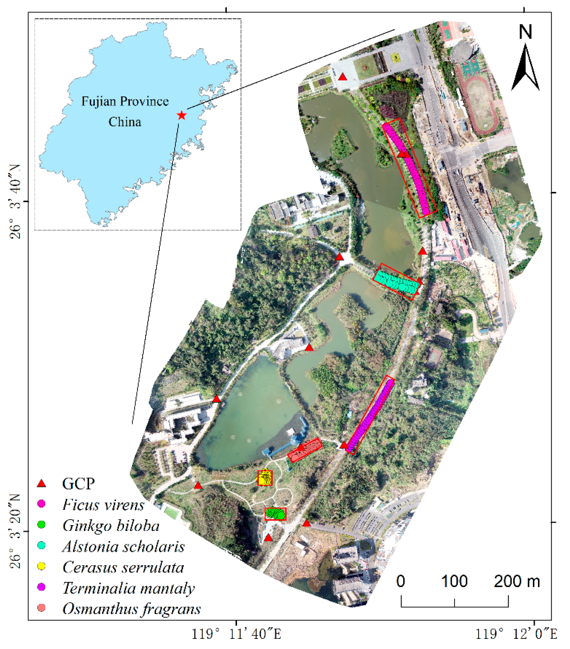
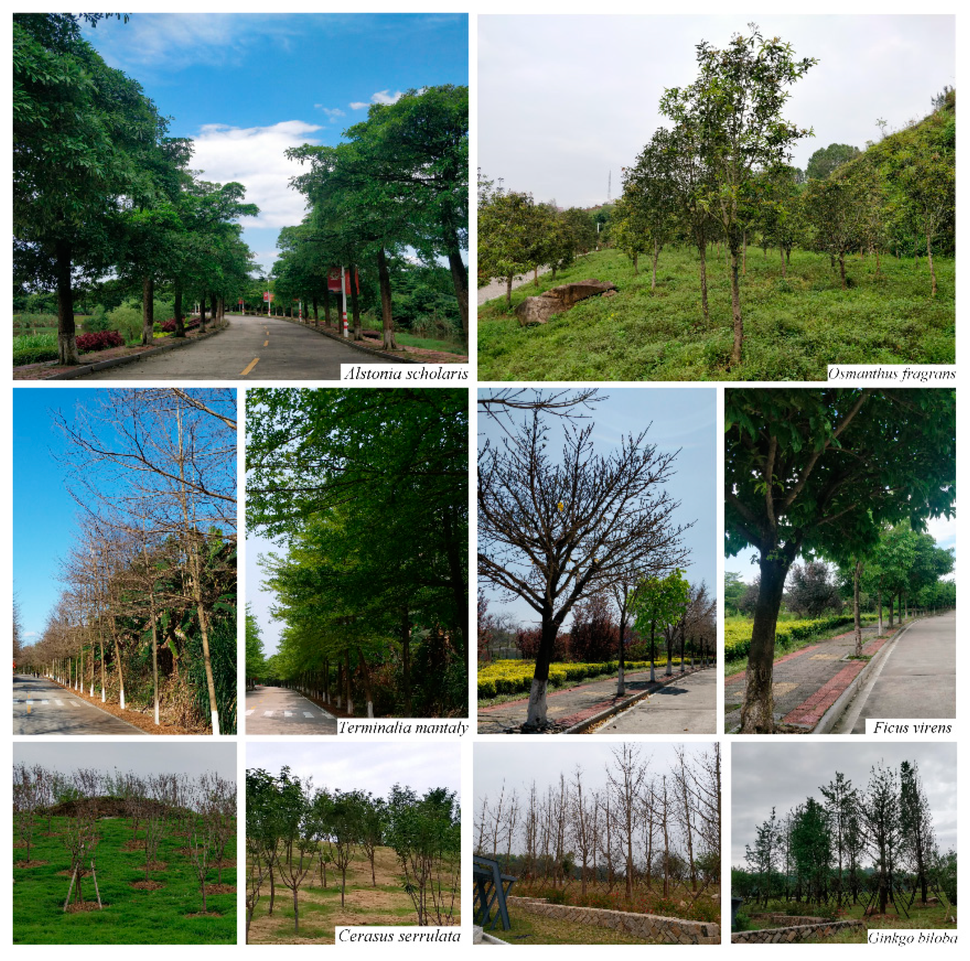
2.1. Study Area
2.2. Field Measurements
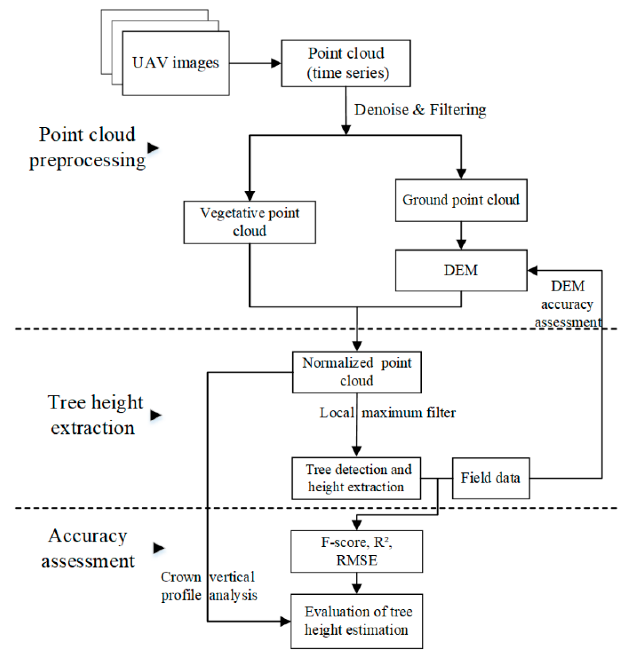
2.3. UAV Image Processing
2.4. Tree Height Extraction and Analysis
2.4.1. Point Cloud Processing
2.4.2. Individual Tree Detection and Tree Height Extraction
2.4.3. Accuracy Assessment
3. Results
3.1. DEM Accuracy
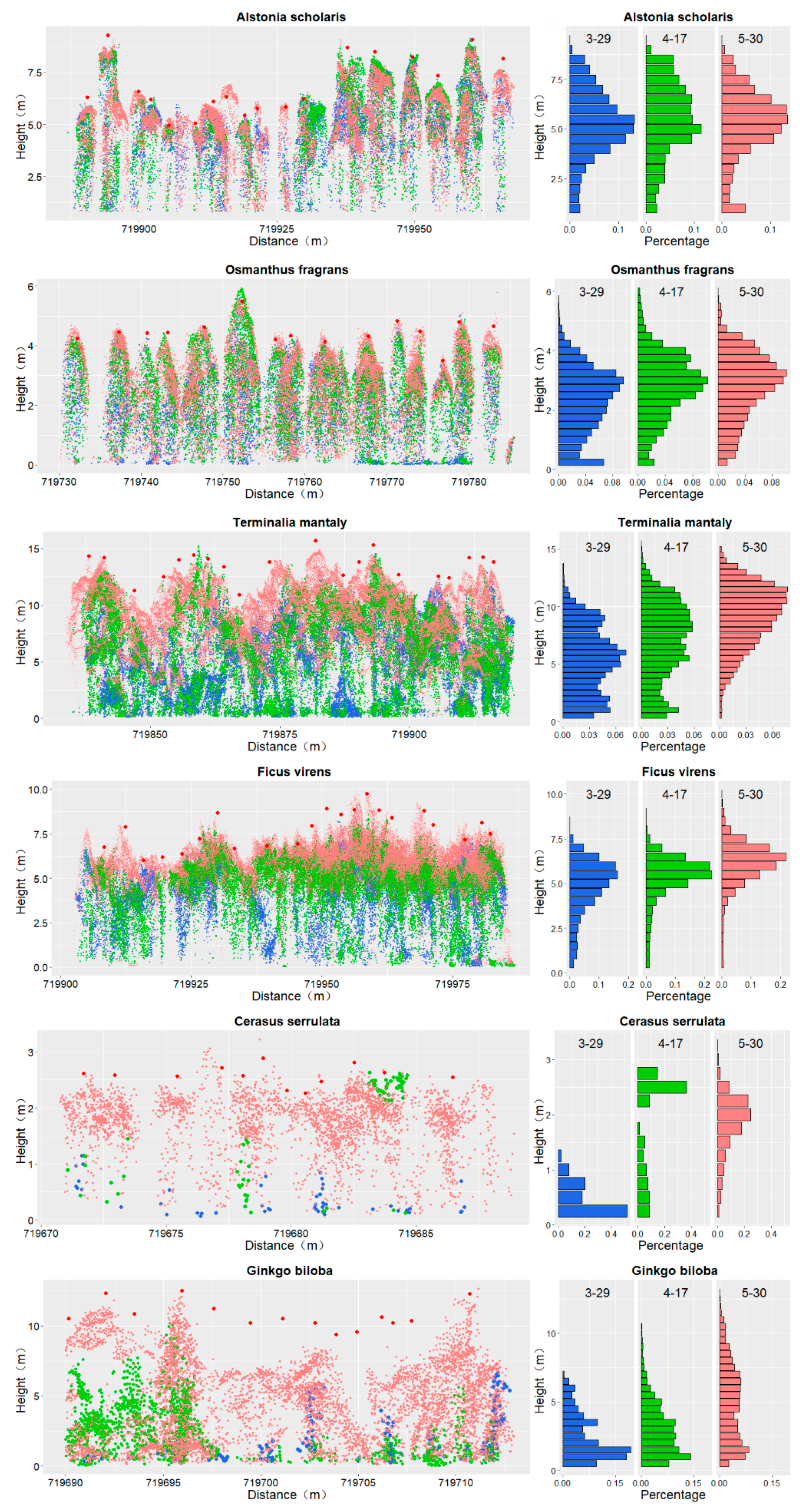
3.2. Tree Point Distribution Time Series
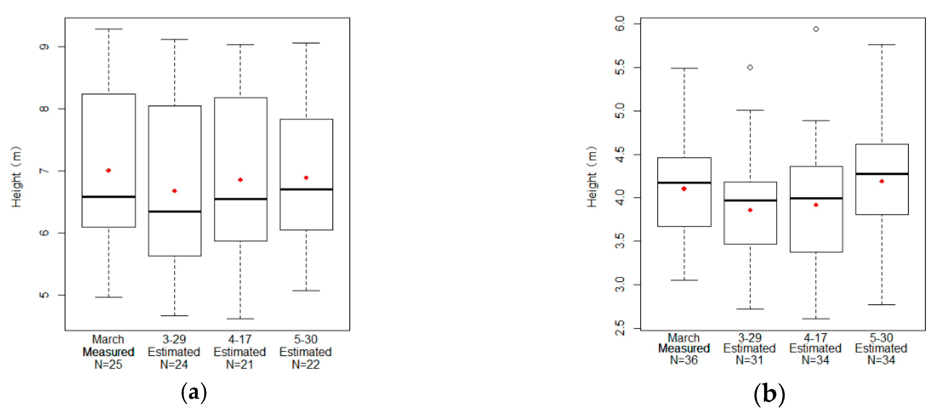
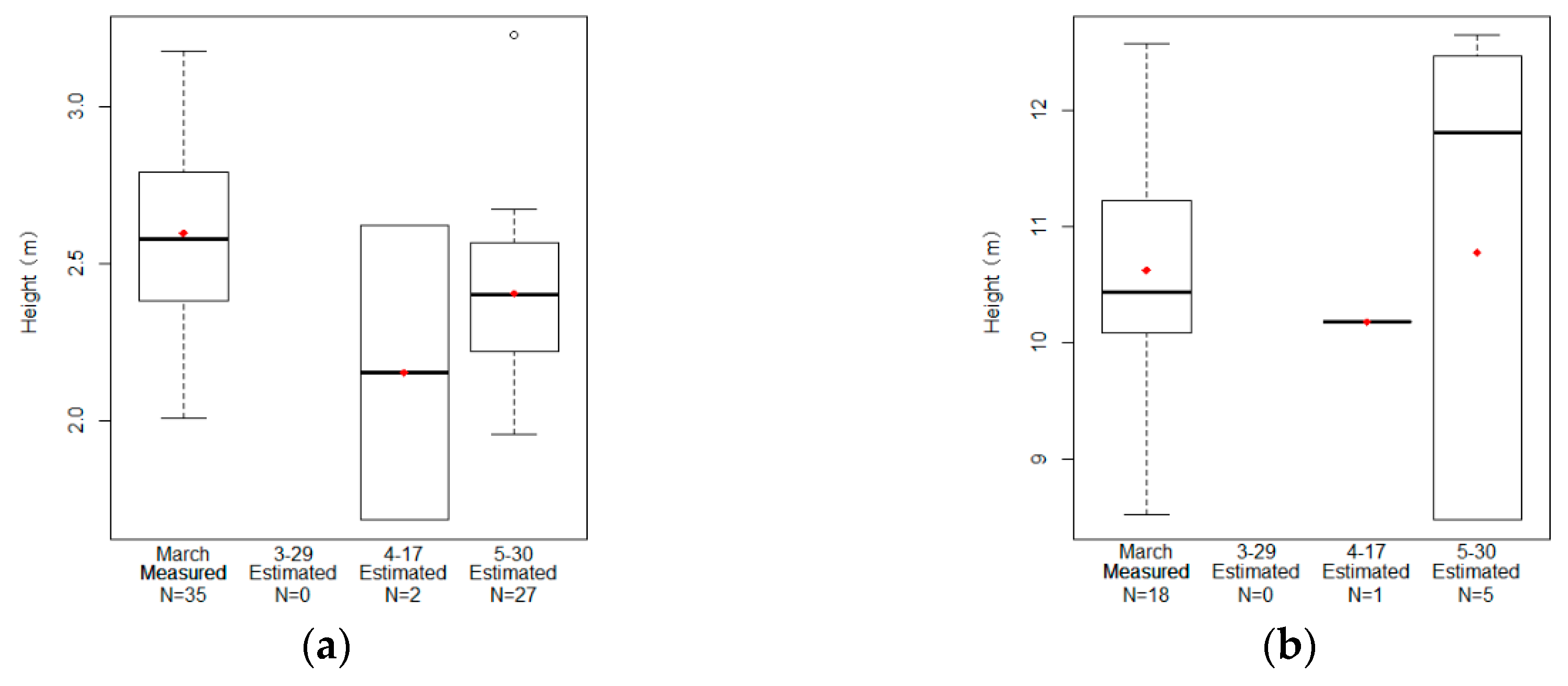
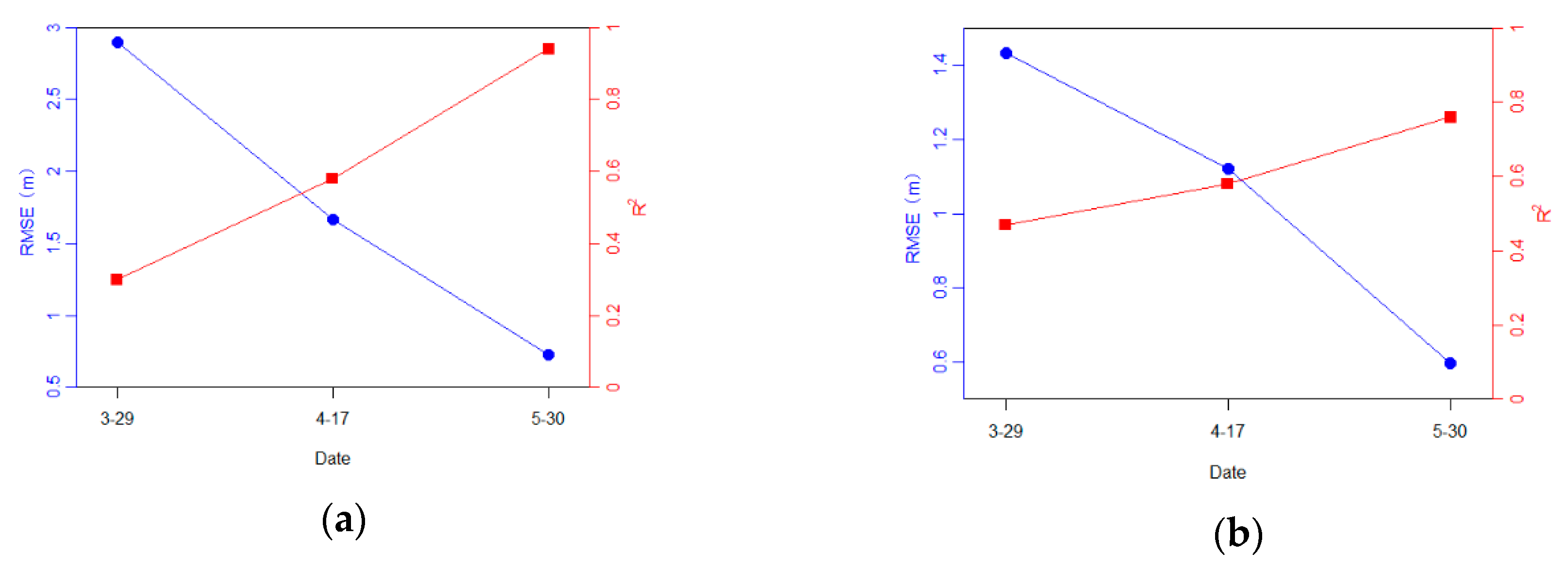
3.3. Tree Detection and Tree Height Evaluation
4. Discussion
5. Conclusions
Author Contributions
Funding
Acknowledgments
Conflicts of Interest
References
- Anderson, J.; Martin, M.E.; Smith, M.; Dubayah, R.O.; Hofton, M.A.; Hyde, P.; Peterson, B.E.; Blair, J.B.; Knox, R.G. The use of waveform lidar to measure northern temperate mixed conifer and deciduous forest structure in New Hampshire. Remote Sens. Environ. 2006, 105, 248–261. [Google Scholar] [CrossRef]
- Erdody, T.L.; Moskal, L.M. Fusion of LiDAR and imagery for estimating forest canopy fuels. Remote Sens. Environ. 2010, 114, 725–737. [Google Scholar] [CrossRef]
- Selkowitz, D.J.; Green, G.; Peterson, B.; Wylie, B. A multi-sensor lidar, multi-spectral and multi-angular approach for mapping canopy height in boreal forest regions. Remote Sens. Environ. 2012, 121, 458–471. [Google Scholar] [CrossRef]
- Bohlin, J.; Wallerman, J.; Fransson, J.E.S. Forest variable estimation using photogrammetric matching of digital aerial images in combination with a high-resolution DEM. Scand. J. For. Res. 2012, 27, 692–699. [Google Scholar] [CrossRef]
- Dandois, J.P.; Ellis, E.C. Remote Sensing of Vegetation Structure Using Computer Vision. Remote Sens. 2010, 2, 1157–1176. [Google Scholar] [CrossRef] [Green Version]
- Krause, S.; Sanders, T.G.; Mund, J.-P.; Greve, K. UAV-Based Photogrammetric Tree Height Measurement for Intensive Forest Monitoring. Remote Sens. 2019, 11, 758. [Google Scholar] [CrossRef]
- Mlambo, R.; Woodhouse, I.H.; Gerard, F.; Anderson, K. Structure from Motion (SfM) Photogrammetry with Drone Data: A Low Cost Method for Monitoring Greenhouse Gas Emissions from Forests in Developing Countries. Forests 2017, 8, 68. [Google Scholar] [CrossRef]
- Goodbody, T.R.H.; Coops, N.C.; White, J.C. Digital Aerial Photogrammetry for Updating Area-Based Forest Inventories: A Review of Opportunities, Challenges, and Future Directions. Curr. For. Rep. 2019, 5, 55–75. [Google Scholar] [CrossRef] [Green Version]
- Wallace, L.; Lucieer, A.; Watson, C.S. Evaluating Tree Detection and Segmentation Routines on Very High Resolution UAV LiDAR Data. IEEE Trans. Geosci. Remote Sens. 2014, 52, 7619–7628. [Google Scholar] [CrossRef]
- Giannetti, F.; Chirici, G.; Gobakken, T.; Næsset, E.; Travaglini, D.; Puliti, S. A new approach with DTM-independent metrics for forest growing stock prediction using UAV photogrammetric data. Remote Sens. Environ. 2018, 213, 195–205. [Google Scholar] [CrossRef]
- White, J.C.; Tompalski, P.; Vastaranta, M.; Wulder, M.A.; Saarinen, S.; Stepper, C.; Coops, N.C. A Model Development and Application Guide for Generating an Enhanced Forest Inventory Using Airborne Laser Scanning Data and an Area-Based Approach; CWFC Information Report FI-X-018; Canadian Forest Service, Pacific Forestry Centre: Victoria, BC, Canada, 2017; p. 38. [Google Scholar]
- St-Onge, B.; Audet, F.; Bégin, J. Characterizing the Height Structure and Composition of a Boreal Forest Using an Individual Tree Crown Approach Applied to Photogrammetric Point Clouds. Forests 2015, 6, 3899–3922. [Google Scholar] [CrossRef]
- Wang, Y.; Hyyppa, J.; Liang, X.; Kaartinen, H.; Yu, X.; Lindberg, E.; Holmgren, J.; Qin, Y.; Mallet, C.; Ferraz, A.; et al. International Benchmarking of the Individual Tree Detection Methods for Modeling 3-D Canopy Structure for Silviculture and Forest Ecology Using Airborne Laser Scanning. IEEE Trans. Geosci. Remote Sens. 2016, 54, 5011–5027. [Google Scholar] [CrossRef] [Green Version]
- Ganz, S.; Käber, Y.; Adler, P. Measuring Tree Height with Remote Sensing—A Comparison of Photogrammetric and LiDAR Data with Different Field Measurements. Forests 2019, 10, 694. [Google Scholar] [CrossRef]
- Ullah, S.; Dees, M.; Datta, P.; Adler, P.; Schardt, M.; Koch, B. Potential of Modern Photogrammetry Versus Airborne Laser Scanning for Estimating Forest Variables in a Mountain Environment. Remote Sens. 2019, 11, 661. [Google Scholar] [CrossRef]
- White, J.C.; Coops, N.C.; Wulder, M.A.; Vastaranta, M.; Hilker, T.; Tompalski, P. Remote Sensing Technologies for Enhancing Forest Inventories: A Review. Can. J. Remote Sens. 2016, 42, 619–641. [Google Scholar] [CrossRef] [Green Version]
- Birdal, A.C.; Avdan, U.; Türk, T. Estimating tree heights with images from an unmanned aerial vehicle. Geomat. Nat. Hazards Risk 2017, 8, 1144–1156. [Google Scholar] [CrossRef] [Green Version]
- Chen, S.; McDermid, G.J.; Castilla, G.; Linke, J. Measuring Vegetation Height in Linear Disturbances in the Boreal Forest with UAV Photogrammetry. Remote Sens. 2017, 9, 1257. [Google Scholar] [CrossRef]
- Dandois, J.P.; Ellis, E.C. High spatial resolution three-dimensional mapping of vegetation spectral dynamics using computer vision. Remote Sens. Environ. 2013, 136, 259–276. [Google Scholar] [CrossRef] [Green Version]
- Dandois, J.; Olano, M.; Ellis, E. Optimal Altitude, Overlap, and Weather Conditions for Computer Vision UAV Estimates of Forest Structure. Remote Sens. 2015, 7, 13895–13920. [Google Scholar] [CrossRef] [Green Version]
- Dempewolf, J.; Nagol, J.; Hein, S.; Thiel, C.; Zimmermann, R. Measurement of Within-Season Tree Height Growth in a Mixed Forest Stand Using UAV Imagery. Forests 2017, 8, 231. [Google Scholar] [CrossRef]
- Nuijten, R.J.; Coops, N.C.; Goodbody, T.R.; Pelletier, G. Examining the Multi-Seasonal Consistency of Individual Tree Segmentation on Deciduous Stands Using Digital Aerial Photogrammetry (DAP) and Unmanned Aerial Systems (UAS). Remote Sens. 2019, 11, 739. [Google Scholar] [CrossRef]
- Mohan, M.; Silva, C.; Klauberg, C.; Jat, P.; Catts, G.; Cardil, A.; Hudak, A.T.; Dia, M. Individual Tree Detection from Unmanned Aerial Vehicle (UAV) Derived Canopy Height Model in an Open Canopy Mixed Conifer Forest. Forests 2017, 8, 340. [Google Scholar] [CrossRef]
- Ota, T.; Ogawa, M.; Mizoue, N.; Fukumoto, K.; Yoshida, S. Forest Structure Estimation from a UAV-Based Photogrammetric Point Cloud in Managed Temperate Coniferous Forests. Forests 2017, 8, 343. [Google Scholar] [CrossRef]
- Miller, E.; Dandois, J.P.; Detto, M.; Hall, J.S. Drones as a Tool for Monoculture Plantation Assessment in the Steepland Tropics. Forests 2017, 8, 168. [Google Scholar] [CrossRef]
- Kattenborn, T.; Sperlich, M.; Bataua, K.; Koch, B. Automatic Single Tree Detection in Plantations using UAV-based Photogrammetric Point clouds. ISPRS Int. Arch. Photogramm. Remote Sens. Spat. Inf. Sci. 2014, XL-3, 139–144. [Google Scholar] [CrossRef] [Green Version]
- Koc-San, D.; Selim, S.; Aslan, N.; San, B.T. Automatic citrus tree extraction from UAV images and digital surface models using circular Hough transform. Comput. Electron. Agric. 2018, 150, 289–301. [Google Scholar] [CrossRef]
- Zarco-Tejada, P.J.; Diaz-Varela, R.; Angileri, V.; Loudjani, P. Tree height quantification using very high resolution imagery acquired from an unmanned aerial vehicle (UAV) and automatic 3D photo-reconstruction methods. Eur. J. Agron. 2014, 55, 89–99. [Google Scholar] [CrossRef]
- Torres-Sánchez, J.; López-Granados, F.; Serrano, N.; Arquero, O.; Peña, J.M. High-Throughput 3-D Monitoring of Agricultural-Tree Plantations with Unmanned Aerial Vehicle (UAV) Technology. PLoS ONE 2015, 10, e130479. [Google Scholar] [CrossRef]
- Torres-Sánchez, J.; de Castro, A.; Peña, J.; Jiménez-Brenes, F.; Arquero, O.; Lovera, M.; López-Granados, F. Mapping the 3D structure of almond trees using UAV acquired photogrammetric point clouds and object-based image analysis. Biosyst. Eng. 2018, 176, 172–184. [Google Scholar] [CrossRef]
- Van Iersel, W.; Straatsma, M.; Addink, E.; Middelkoop, H. Monitoring height and greenness of non-woody floodplain vegetation with UAV time series. ISPRS J. Photogramm. Remote Sens. 2018, 141, 112–123. [Google Scholar] [CrossRef]
- Granholm, A.; Lindgren, N.; Olofsson, K.; Nyström, M.; Allard, A.; Olsson, H. Estimating vertical canopy cover using dense image-based point cloud data in four vegetation types in southern Sweden. Int. J. Remote Sens. 2017, 38, 1820–1838. [Google Scholar] [CrossRef]
- Panagiotidis, D.; Abdollahnejad, A.; Surový, P.; Chiteculo, V. Determining tree height and crown diameter from high-resolution UAV imagery. Int. J. Remote Sens. 2017, 38, 2392–2410. [Google Scholar] [CrossRef]
- Thiel, C.; Schmullius, C. Comparison of UAV photograph-based and airborne lidar-based point clouds over forest from a forestry application perspective. Int. J. Remote Sens. 2016, 38, 2411–2426. [Google Scholar] [CrossRef]
- Wang, Y.; Lehtomäki, M.; Liang, X.; Pyörälä, J.; Kukko, A.; Jaakkola, A.; Liu, J.; Feng, Z.; Chen, R.; Hyyppä, J. Is field-measured tree height as reliable as believed—A comparison study of tree height estimates from field measurement, airborne laser scanning and terrestrial laser scanning in a boreal forest. ISPRS J. Photogramm. Remote Sens. 2019, 147, 132–145. [Google Scholar] [CrossRef]
- Huang, H.; Zhang, H.; Chen, C.; Tang, L. Three-dimensional digitization of the arid land plant Haloxylon ammodendron using a consumer-grade camera. Ecol. Evol. 2018, 8, 5891–5899. [Google Scholar] [CrossRef]
- Isenburg, M. Lastools—Efficient Tools for Lidar Processing. Version 190114. 2019. Available online: http://lastools.org (accessed on 20 January 2019).
- Zhang, W.; Qi, J.; Wan, P.; Wang, H.; Xie, D.; Wang, X.; Yan, G. An Easy-to-Use Airborne LiDAR Data Filtering Method Based on Cloth Simulation. Remote Sens. 2016, 8, 501. [Google Scholar] [CrossRef]
- Popescu, S.C.; Wynne, R.H. Seeing the Trees in the Forest: Using Lidar and Multispectral Data Fusion with Local Filtering and Variable Window Size for Estimating Tree Height. Photogramm. Eng. Remote Sens. 2004, 70, 589–604. [Google Scholar] [CrossRef]
- Roussel, J.-R.; Auty, D. LidR: Airborne LiDAR Data Manipulation and Visualization for Forestry Applications. Available online: https://rdrr.io/cran/lidR/ (accessed on 28 May 2019).
- Li, W.; Guo, Q.; Jakubowski, M.K.; Kelly, M. A New Method for Segmenting Individual Trees from the Lidar Point Cloud. Photogramm. Eng. Remote Sens. 2012, 78, 75–84. [Google Scholar] [CrossRef] [Green Version]
- Goodbody, T.R.; Coops, N.C.; Hermosilla, T.; Tompalski, P.; Pelletier, G. Vegetation Phenology Driving Error Variation in Digital Aerial Photogrammetrically Derived Terrain Models. Remote Sens. 2018, 10, 1554. [Google Scholar] [CrossRef]


| Species | Num. | Tree Height (m) | Canopy Condition | |||||
|---|---|---|---|---|---|---|---|---|
| Min | Max | Mean | STD | Mar. 29 | Apr. 17 | May 30 | ||
| OF | 36 | 3.054 | 5.494 | 4.107 | 0.532 | Leaf-on | Leaf-on | Leaf-on |
| AS | 25 | 4.961 | 9.285 | 7.009 | 1.269 | |||
| TM | 30 | 7.235 | 15.791 | 13.077 | 1.774 | Some old leaves | Sparse new leaves | Full leaves |
| FV | 30 | 5.729 | 9.733 | 7.432 | 1.604 | Leaf-off | ||
| CS | 35 | 2.008 | 3.176 | 2.596 | 0.279 | Leaf-off | Sparse | denser |
| GB | 18 | 8.527 | 12.575 | 10.626 | 1.150 | |||
| Species. | Sample Number in March | Sample Number in June | Mean (m) | STD (m) |
|---|---|---|---|---|
| AS | 25 | 6 | 0.045 | 0.025 |
| OF | 36 | 10 | 0.190 | 0.095 |
| TM | 30 | 10 | 0.175 | 0.147 |
| FV | 30 | 11 | 0.087 | 0.118 |
| CS | 35 | 10 | 0.070 | 0.083 |
| GB | 18 | 9 | −0.026 | 0.101 |
| Species | Mean of Measured Crown | Size of Fixed Window | Minimum of Measured Tree Height | hmin Threshold |
|---|---|---|---|---|
| AS | 3.95 | 5.0 | 4.961 | 4 |
| OF | 2.70 | 3.0 | 3.054 | 2.5 |
| TM | 3.84 | 5.0 | 8.527 | 8 |
| CS | 1.28 | 2.0 | 2.008 | 1.5 |
| GB | 6.73 | 7.0 | 7.235 | 7 |
| FV | 6.70 | 7.0 | 5.729 | 5 |
| Species. | Number of Samples | Date | RMSEH (m) | ME (m) |
|---|---|---|---|---|
| AS | 25 | Mar. 29 | 0.354 | 0.213 |
| Apr. 17 | 0.344 | 0.206 | ||
| May 30 | 0.290 | 0.012 | ||
| TM | 30 | Mar. 29 | 0.174 | 0.129 |
| Apr. 17 | 0.233 | 0.185 | ||
| May 30 | 0.187 | 0.009 | ||
| FV | 30 | Mar. 29 | 0.274 | 0.172 |
| Apr. 17 | 0.336 | 0.232 | ||
| May 30 | 0.240 | 0.009 |
| Species | Date | Num. of Detected Trees | Num. of Points per Tree | Point Density Ratio |
|---|---|---|---|---|
| AS | Mar. 29 | 24 | 560 | 1:0.71:1.59 |
| Apr. 17 | 21 | 400 | ||
| May 30 | 22 | 893 | ||
| OF | Mar. 29 | 31 | 246 | 1:1.43:1.87 |
| Apr. 17 | 34 | 352 | ||
| May 30 | 34 | 460 | ||
| TM | Mar. 29 | 18 | 643 | 1:1.55:4.52 |
| Apr. 17 | 20 | 997 | ||
| May 30 | 24 | 2905 | ||
| FV | Mar. 29 | 10 | 1040 | 1:1.58:2.86 |
| Apr. 17 | 19 | 1644 | ||
| May 30 | 20 | 2977 | ||
| CS | Mar. 29 | 0 | NA | NA:1:3.16 |
| Apr. 17 | 2 | 24 | ||
| May 30 | 27 | 76 | ||
| GB | Mar. 29 | 0 | NA | NA:1:1.15 |
| Apr. 17 | 1 | 700 | ||
| May 30 | 5 | 808 |
| Species. | Date. | Num. of Measured | Num. of Detected | TP | FN | FP | r | p | F | RMSE (m) | ME (m) | R2 |
|---|---|---|---|---|---|---|---|---|---|---|---|---|
| AS | Mar. 29 | 25 | 24 | 24 | 1 | 0 | 0.96 | 1.00 | 0.98 | 0.591 | −0.368 | 0.88 |
| Apr. 17 | 21 | 21 | 4 | 0 | 0.84 | 1.00 | 0.91 | 0.434 | −0.257 | 0.92 | ||
| May 30 | 22 | 22 | 3 | 0 | 0.88 | 1.00 | 0.94 | 0.486 | −0.153 | 0.87 | ||
| OF | Mar. 29 | 36 | 32 | 31 | 5 | 1 | 0.86 | 0.97 | 0.91 | 0.378 | −0.256 | 0.79 |
| Apr. 17 | 34 | 34 | 2 | 0 | 0.94 | 1.00 | 0.97 | 0.359 | −0.214 | 0.81 | ||
| May 30 | 34 | 34 | 2 | 0 | 0.94 | 1.00 | 0.97 | 0.354 | 0.037 | 0.74 | ||
| TM | Mar. 29 | 30 | 19 | 18 | 12 | 1 | 0.60 | 0.95 | 0.73 | 2.894 | −2.615 | 0.30 |
| Apr. 17 | 20 | 20 | 10 | 0 | 0.67 | 1.00 | 0.80 | 1.665 | −1.367 | 0.58 | ||
| May 30 | 29 | 24 | 6 | 5 | 0.80 | 0.83 | 0.81 | 0.729 | −0.632 | 0.94 | ||
| FV | Mar. 29 | 30 | 31 | 10 | 20 | 21 | 0.33 | 0.32 | 0.33 | 1.433 | −1.339 | 0.47 |
| Apr. 17 | 34 | 19 | 11 | 15 | 0.63 | 0.56 | 0.59 | 1.110 | −0.882 | 0.58 | ||
| May 30 | 28 | 20 | 10 | 8 | 0.67 | 0.71 | 0.69 | 0.597 | 0.215 | 0.76 | ||
| CS | Mar. 29 | 35 | 0 | 0 | 35 | 0 | NA | NA | NA | NA | NA | NA |
| Apr. 17 | 2 | 2 | 33 | 0 | 0.06 | 1.00 | 0.11 | 0.644 | −0.462 | NA | ||
| May 30 | 34 | 27 | 8 | 7 | 0.77 | 0.79 | 0.78 | 0.309 | −0.182 | 0.33 | ||
| GB | Mar. 29 | 18 | 0 | 0 | 18 | 0 | NA | NA | NA | NA | NA | NA |
| Apr. 17 | 1 | 1 | 17 | 0 | 0.06 | 1.00 | 0.11 | 2.393 | NA | NA | ||
| May 30 | 5 | 5 | 13 | 0 | 0.28 | 1.00 | 0.43 | 1.132 | −0.749 | NA |
© 2019 by the authors. Licensee MDPI, Basel, Switzerland. This article is an open access article distributed under the terms and conditions of the Creative Commons Attribution (CC BY) license (http://creativecommons.org/licenses/by/4.0/).
Share and Cite
Huang, H.; He, S.; Chen, C. Leaf Abundance Affects Tree Height Estimation Derived from UAV Images. Forests 2019, 10, 931. https://doi.org/10.3390/f10100931
Huang H, He S, Chen C. Leaf Abundance Affects Tree Height Estimation Derived from UAV Images. Forests. 2019; 10(10):931. https://doi.org/10.3390/f10100931
Chicago/Turabian StyleHuang, Hongyu, Shaodong He, and Chongcheng Chen. 2019. "Leaf Abundance Affects Tree Height Estimation Derived from UAV Images" Forests 10, no. 10: 931. https://doi.org/10.3390/f10100931
APA StyleHuang, H., He, S., & Chen, C. (2019). Leaf Abundance Affects Tree Height Estimation Derived from UAV Images. Forests, 10(10), 931. https://doi.org/10.3390/f10100931