Article

Division of Lacustrine Environment and Significance for Shale Oil Exploration: A Case Study of the Third Member of Shahejie Formation in Dongying Sag

by
He Zhao
1,2,
Hongliang Wang
1,2,* and
Nana Mu
1,2
1
School of Energy Resources, China University of Geosciences, Beijing 100083, China
2
Key Laboratory of Marine Reservoir Evolution and Hydrocarbon Enrichment Mechanism, China University of Geosciences, Beijing 100083, China
*
Author to whom correspondence should be addressed.
Energies 2025, 18(12), 3086; https://doi.org/10.3390/en18123086
Submission received: 24 April 2025 / Revised: 25 May 2025 / Accepted: 7 June 2025 / Published: 11 June 2025

Abstract

The third member of the Shahejie Formation (Es3) in Dongying Sag is noteworthy for its abundance of laminated shale, considerable thickness, and high organic matter content, with carbonate interbeds playing a crucial role in reservoir properties. The salinity and pH of water influence the change of sedimentary environment and the mineral composition of sediment, thereby affecting the distribution characteristics of carbonate interbeds. Based on geochemical data from 8721 samples in the Dongying Sag, this study systematically analyzed the salinity and pH characteristics. This study is the first to develop an environmental zoning framework based on aqueous medium characteristics of aqueous media, and the favorable shale oil enrichment areas in Es3 were identified by integrating carbonate mineral content analysis. The results showed that the lower part of Es3 is dominated by a zone with high salinity–middle pH, and middle salinity–high pH with rich carbonate. Combining the development of carbonate interbeds, it is speculated that the sweet spots in Es3 are high salinity–middle pH and middle salinity–high pH. The favorable areas are concentrated in the lower part of Es3, including the western and northeastern parts of the Lijin Sub-Sag and the northern gentle slope of Guangrao. It provides a novel perspective on shale oil exploration through lacustrine environmental zonation.

1. Introduction

The focus of oil and gas exploration has gradually shifted to unconventional reservoirs in recent years, especially the exploration and development of shale oil. The main shale oil exploration and development areas in the world are concentrated in passive continental margin basins and rift basins formed under the effect of tension [1]. It is mainly distributed in North America, the Middle East, Western Europe, Siberia, and eastern Asia. The breakthrough in shale oil and gas exploration and development technologies, particularly the application of horizontal drilling and hydraulic fracturing, has led to a dramatic surge in U.S. shale oil production [2]. Data from the U.S. Energy Information Administration (EIA) indicate that, in 2022, U.S. shale oil output reached 378 million tons, accounting for 64% of its total crude oil production. The marine shale deposits in North America are relatively stable and continuous. The oil layer continuity is good, and it is located in the window of light oil–condensate oil. The reservoir quality is also good, with a high content of brittle minerals and easy fracturing. The favorable area is large, and the cumulative productivity of a single well is high. Whereas China’s shale oil is mainly formed in continental sedimentary basins, characterized by significant variations in total organic carbon, relatively low maturity, poorer reservoir properties, lower porosity, complex mineral composition, thinner oil layers, heavier oil quality, and lower pressure coefficients [3,4]. The exploration and development of shale oil have made some breakthroughs in Ordos, Junggar, Bohai Bay, Santanghu, Sichuan, and Qaidam Basin [5,6,7,8,9]. In 2024, China’s first national continental shale oil demonstration zone, Xinjiang Jimsar National Continental shale Oil Demonstration Zone, achieved a cumulative output of over one million tons. The annual output of shale oil in Shengli Jiyang Shale oil National Demonstration Zone has exceeded 500,000 tons, the cumulative oil production has exceeded 1 million tons, and the daily oil production of a single well has reached 30 tons. As a typical faulted lacustrine basin in the Bohai Bay Basin, the Jiyang Depression is an important research area for shale oil. Many researchers have made a lot of discussions on the lithofacies types, reservoir space genesis, pore development, and evolution of Paleogene shale in Jiyang Depression, especially in Dongying Sag [10,11,12].
There is a large thickness of mudstone and a high abundance of organic matter in the low part of Es3 and the upper part of Es4 of the Jiyang Depression. The amount of free oil resources reached 4.1 billion tons, of which 2.3 billion tons are in Dongying Sag [13]. A large number of laminated carbonate rocks are developed in the main reservoir section. These carbonate rocks are mainly composed of calcite, which is very thin and mostly in the centimeter to millimeter level [14,15,16,17,18]. The kind of laminated carbonate rock in the organic-rich shale section is not unique to the Jiyang Depression. It has been found in the Araripe Basin in northeastern Brazil, the Uinta Basin in the United States, the Cankiri-Corum Basin in Turkey, the Midland Valley Basin in Scotland, the Ordos Basin, and the Santanghu Basin in China [19,20,21,22]. This has led many scholars to further study the carbonate rocks in lacustrine shale. It is generally believed that the dissolution of carbonate rocks is conducive to the self-generation and self-storage of shale oil. The original diagenetic environment of the continental sequence is closely related to the geochemical characteristics of the lake water in the basin. The salinity and pH of water directly control the chemical precipitation of the lake.
The analysis of aqueous medium characteristics is mainly applied in aspects such as water quality assessment, water resource management, and climate change research. It is less applied in the field of petroleum geology and mainly focuses on the evolution of sedimentary environments. This study is the first to develop an environmental zoning framework based on aqueous medium characteristics of aqueous media, analyzing and comparing the characteristics of each environmental zone from the organic matter content, the main trace element content, the carbonate mineral content, and other points of view. This affects the lithological composition of sediments and thereby influences the reservoir characteristics and the development of source rocks. It could predict the favorable accumulation area of shale oil in Es3 of Dongying Sag from the macro perspective, which provides a novel perspective on shale oil exploration through lacustrine environmental zonation.

2. Materials and Methods

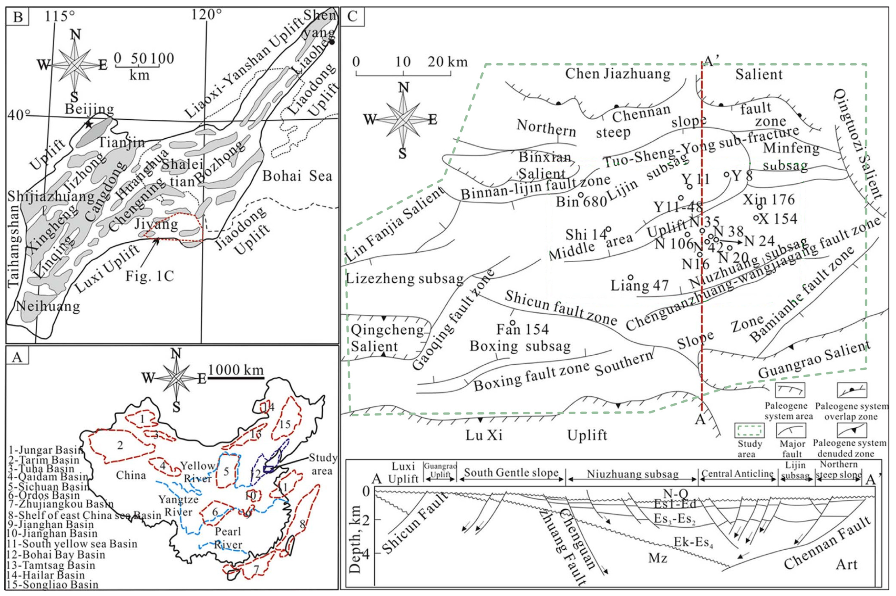
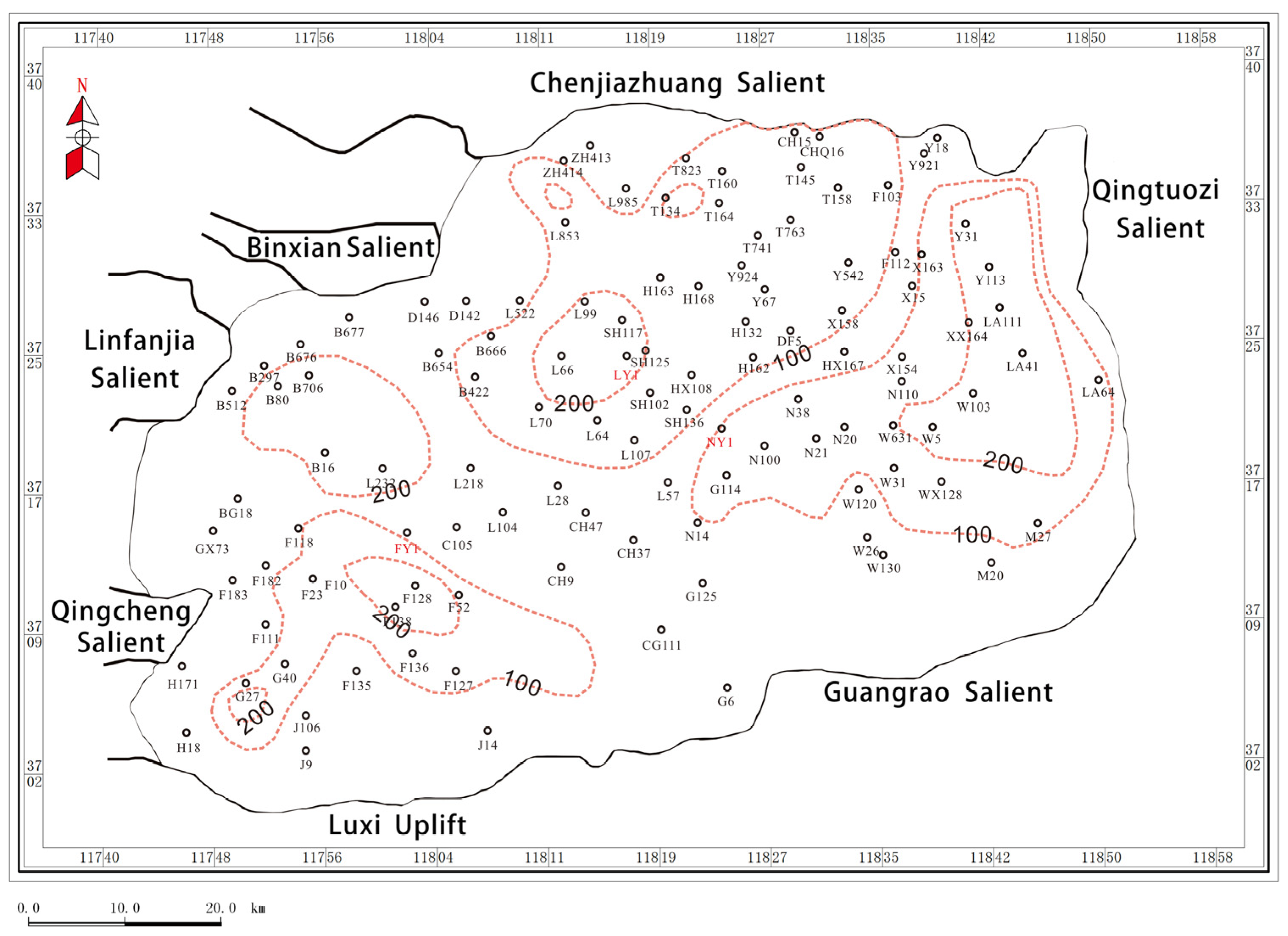
2.1. Geological Settings

In the northern part of Shandong Province, Dongying Sag is the area with the most abundant oil and gas in the Jiyang Depression. It covers about 5850 km2. It faces Qingdong Sag in the east and has an over-relationship with Luxi Uplift and Guangrao Salient in the south. In the west, it is bounded by Qingcheng Salient and Linfanjia Salient, and, in the north, it reaches Binxian Salient and Chenjiazhuang Salient. In the formation and evolution of the basin, the fault activity in the north is the strongest, making Dongying Sag a typical asymmetrical braided basin with a “steep dip angle in the north limb and gentle in the south” (Figure 1) [23].
The period from the middle and late deposition of Es4 to the early deposition of Es3 is the intense fault depression of Dongying Sag. In the middle and late stages of Es4, the climate changed from drought to wet, accompanied by an increase in precipitation, the subsidence of the basin, the expansion of the water area, and a rise in salinity. The rapid increase in the accommodating space of the basin under the control of tectonic movement and climate. The humid climate provides sufficient moisture, causing the lake level to rise and forming a lake intrusion system. This period had a humid climate and abundant moisture. According to the results of literature research, the sedimentary period of the Shahejie Formation in the Paleogene of the Jiyang Depression was once affected by seawater or was briefly connected to the sea. In the early sedimentary stage of Es3, the climate was wet, with the lake basin increasing and the basin fault depression enhancing. The accommodating space was larger [24,25,26]. The widely distributed deep water to semi-deep water environment provides favorable conditions and places for the deposition of fine-grained materials. It provides conditions for the formation of shale oil.
The main factors affecting the reservoir conditions of Paleogene shale oil in Dongying Sag include rock structure, material composition, recrystallization and dissolution of carbonate minerals, thermal evolution of organic matter, and intensity of dolomitization. The common reservoir space types of laminated shale and sandstone interlayer are mainly intergranular pores and dissolution pores, with a large pore size range and a high proportion of macropores. Most pores are filled with iron dolomite, a flake mixed-layer of illite-montmorillonite and pyrite. In the local area, due to the significant dissolution of feldspar, the pore connectivity is improved. The laminated shale rich in organic matter and carbonate minerals has the best pores and, due to its total porosity, pore connectivity, and pores conducive to the occurrence of free oil, can be regarded as a favorable lithofacies type [27]. The diagenetic environment of Es4 in Niuzhuang Sag is controlled by aqueous medium, hydrocarbon generation, and acid expulsion. The main diagenesis includes the dissolution of calcite, dolomite, pyrite, siderite, quartz, siliceous metasomatism, and dolomitization. The content and occurrence of inorganic minerals such as carbonates, clays, and terrigenous clasts affect the ability of shale oil reservoirs. Dissolution and recrystallization diagenesis are important ways to improve storage permeability [28]. Generally, the organic matter in the sedimentary environment is more developed in the quiet and stratified environment of lake water. The dissolution of organic acids to adjacent carbonate laminae increases reservoir space [29,30,31]. The effective reservoir space in the self-storage shale reservoir is the matrix gap, which mainly comes from the pores and fissures between or inside the crystals of carbonate minerals [32].

2.2. Data Collection

This study is based on data from over 270 wells in Es3 of Dongying Sag, including core data, logging data, and geochemical data. Three shale oil exploration wells are the focus of this research, among which the thickness of Es3 is 195 m for well FY1, 115 m for well LY1, and 62 m for well NY1. It provides a reasonable data basis for the analysis of characteristics.

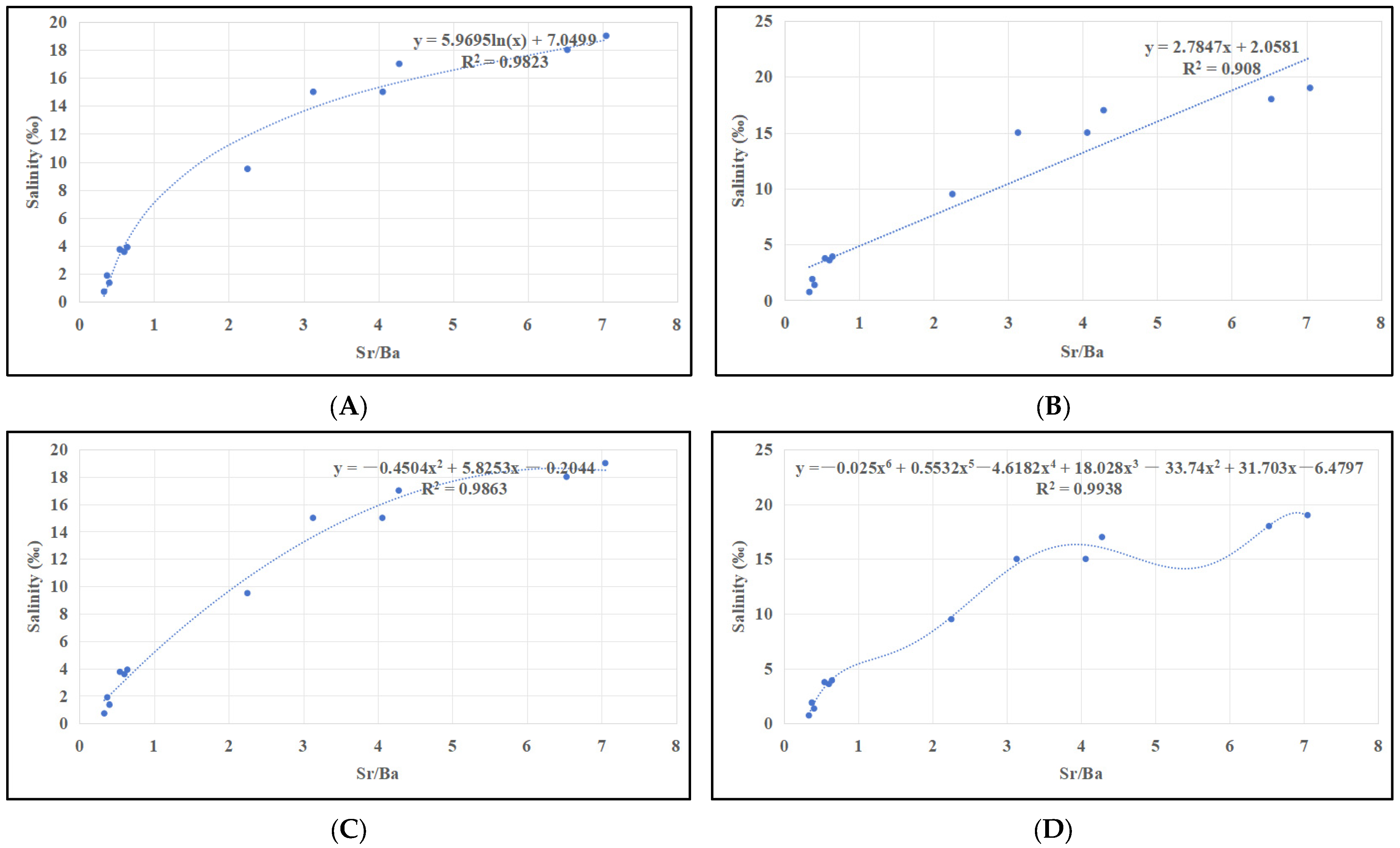
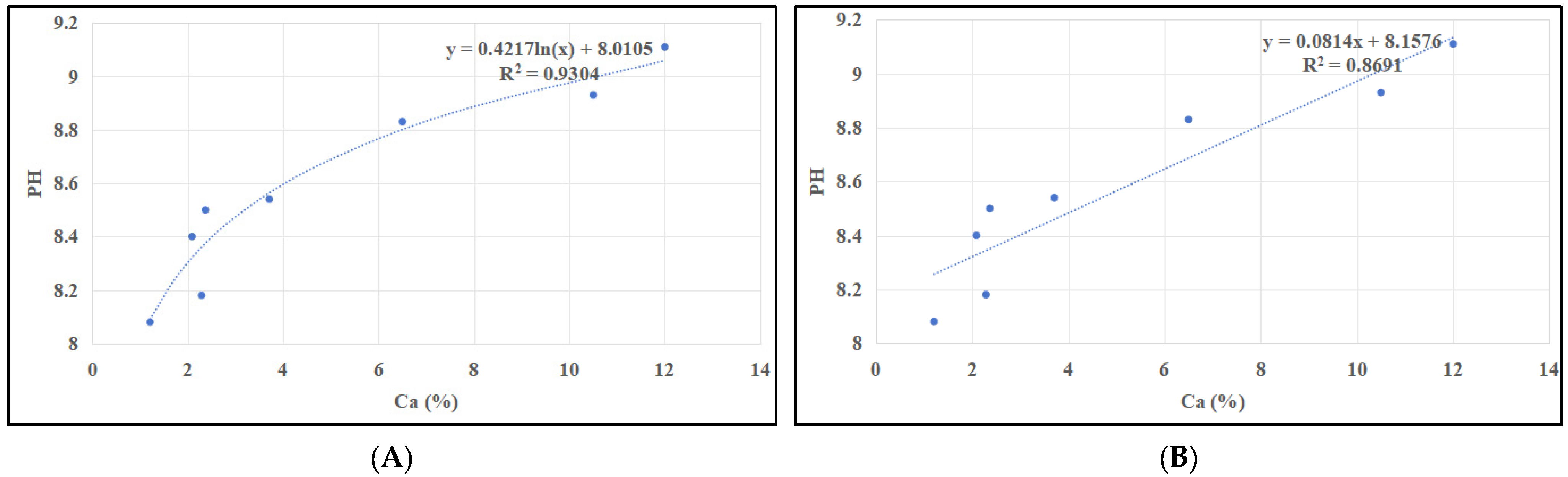
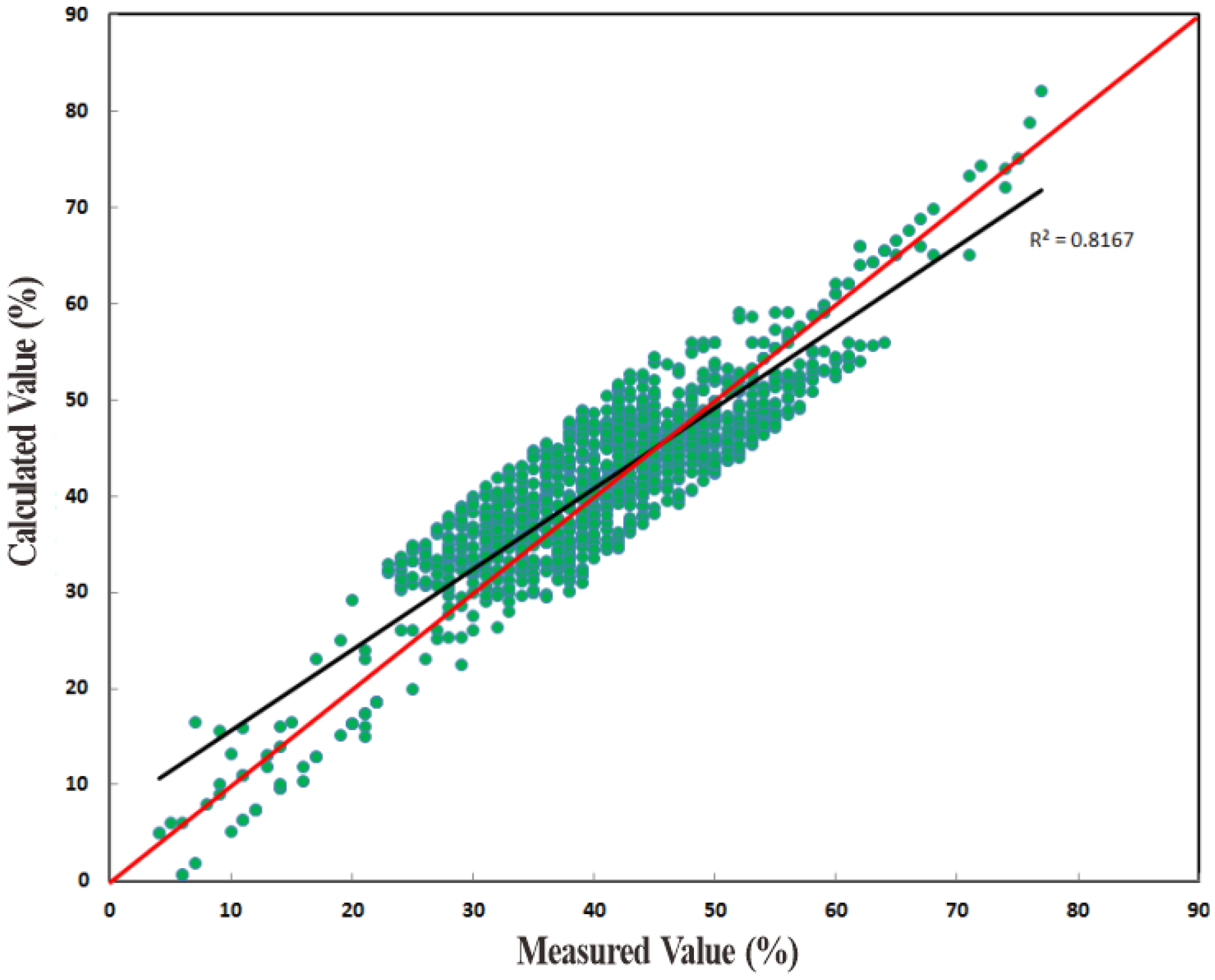
2.3. Calculation Formula of Aqueous Medium Characteristics

The fitting equations in this paper are based on the author’s participation in the project ‘Characterization of ancient lake sedimentary water medium in the third member of Dongying Sag’.
The data are from the Shengli oil field exploration and Development Research Institute. The major elements were tested by X-ray fluorescence spectrometer (Axios Max) using the alkali-fused glass method. The trace elements were tested by an inductively coupled plasma mass spectrometer (X-Serise II) using acid melting. The systematic errors were less than 5‰.
The fitting equation of salinity by Sr/Ba is shown in Table 1 and Figure 2. By comparing logarithmic fitting, linear function fitting, and multiple function fitting, it is found that the fitting of hexagonal polynomials has the best effect. However, the discriminant effect of Sr/Ba is not obvious in the application process. We sought to improve the recognition of Sr/Ba in a sedimentary environment by the selective extraction method [33]. The sediments were soaked in hydrochloric acid, and only the strontium and barium that migrated into the sediments during the deposition process were extracted, as far as possible, so as to eliminate the interference of strontium and barium from other sources on the identification of the sedimentary environment to the greatest extent.
y = −0.025x6 + 0.5532x5 − 4.6182x4 + 18.028x3 − 33.74x2 + 31.703x − 6.4797 (R2 = 0.9938)
The fitting equation of pH by calcium content (Table 2 and Figure 3). By comparing logarithmic fitting, linear function fitting, and multiple function fitting, it is found that cubic polynomial fitting has the best effect.
y = 0.0019x3 − 0.0453x2 + 0.3827x + 7.6933 (R2 = 0.93)
It is found that the logging parameters with higher Pearson values are AC, CNL, and R25 (Table 3 and Figure 4). The fitting equation of the carbonate mineral content by the logging data is as follows:
y = 39.152 + 0.253 × AC − 0.869 × CNL + 0.094 × R25

2.4. Analysis Method

This study combines the overlapping method in mathematical analysis, that is, one image is overlaid on another image to obtain a strong visual image. This method is often used in logging curve interpretation. Overlapping two or more different logging curves of the same scale will cause amplitude deviation due to different formation properties. According to this phenomenon, the oil-bearing horizons and the mobility of oil and gas can be understood intuitively.
The calculation and analysis of aqueous media characteristics and the plane analysis are the basis. The overlapping treatment can visually analyze the salinity and pH of different zones. The characteristics of the partition are summarized from the perspectives of lithofacies, aqueous medium, elements, and organic matter.
The overall steps of this research are as follows: (1) collection and organization of logging data and element test data; (2) fitting calculation of water medium parameters; (3) the water medium area division is carried out by the overlapping method; (4) different zoning characteristics and reservoir evaluation.

3. Results

3.1. Basis and Scheme of Environmental Division

The salinity and pH control the chemical precipitation of the lake, and the environmental changes controlled by the aqueous medium affect the distribution characteristics of carbonate minerals.
The ratio of Sr to Ba is often used to distinguish the marine and terrestrial sedimentary environments. It has been recognized by many scholars that the ratio is larger than 1 in marine sediments and smaller than 1 in continental sediments. The salinity division values calculated by Formula (1) are 4‰ and 11‰ (Figure 5).
In the alkaline lakes, the pH value is closely related to the Ca content. Because it mainly exists in the form of strong alkali and weak acid salt ions in the water body, the pH value is small, and the water medium is rarely precipitated when it is acidic. The stronger the alkalinity is, the easier it is to precipitate. Therefore, the Ca content can be used to reflect the pH value of the water body [34]. Combined with the distribution of the Ca content in the study area, 4.5% and 8.5% near the extreme value of formula (2) are selected. Less than 4.5% is the weak acid environment, from 4.5% to 8.5% is the transitional environment, and more than 8.5% is the alkaline environment. The pH partition values calculated by Formula (2) are 8.65 and 8.85 (Figure 6).
The maximum paleo-salinity of Es3L is 36.88‰, the minimum is 0.19‰, and the average is 6.2‰, which is most from 3‰ to 9‰. This part of the data accounts for more than 85% of the total data, and most sample points greater than 9‰ are located in the lower section of the profile. The overall pattern of Es3L is “two low areas and one high” (Figure 5A). The maximum paleo-salinity of Es3M is 30.09‰, the minimum is 0.05‰, and the average is 2.68‰, which is concentrated from 2‰ to 8‰. This part of the data accounts for more than 90% of the total data. The Es3M still shows a pattern of “two low and one high” (Figure 5B). The maximum paleo-salinity of Es3U is 17.75‰, the minimum is 0.03‰, and the average is 2.47‰, mainly from 2‰ to 6‰. This part of the data accounts for more than 85% of the total data. The low salinity area in Es3U further expanded (Figure 5C).
The maximum pH value of Es3L is 9.38, the minimum value is 7.66, and the average value is 8.74, which is concentrated from 8.4 to 8.9. This part of the data accounts for more than 90%. Most sample points larger than 8.9 are located in Es3L on the profile, and the middle and high value areas are expected simultaneously. In the plane, two high-value areas are in the center and two low-value regions on both sides (Figure 6A). The maximum pH value of Es3M is 9.21, the minimum value is 7.52, and the average value is 8.40, which is concentrated from 8.3 to 8.6. This part of the data accounts for more than 90% of the total data. On the plane of the Es3M, the pH value along the northwest to southeast shows a banded feature of “two highs with one low” (Figure 6B). The maximum pH value of Es3U is 9.16, the minimum value is 7.44, and the average value is 8.28, mostly from 8.1 to 8.6. This part of the data accounts for more than 85% of the total data. Es3U is also characterized by two highs and one low (Figure 6C).
According to the environmental zoning division index of the study area, the plane distribution map is drawn, and the high, middle, and low range areas are divided. The same geological period plane map is superimposed, and the study area is divided into nine regions, and the salinity and pH characteristics of different regions are analyzed intuitively.

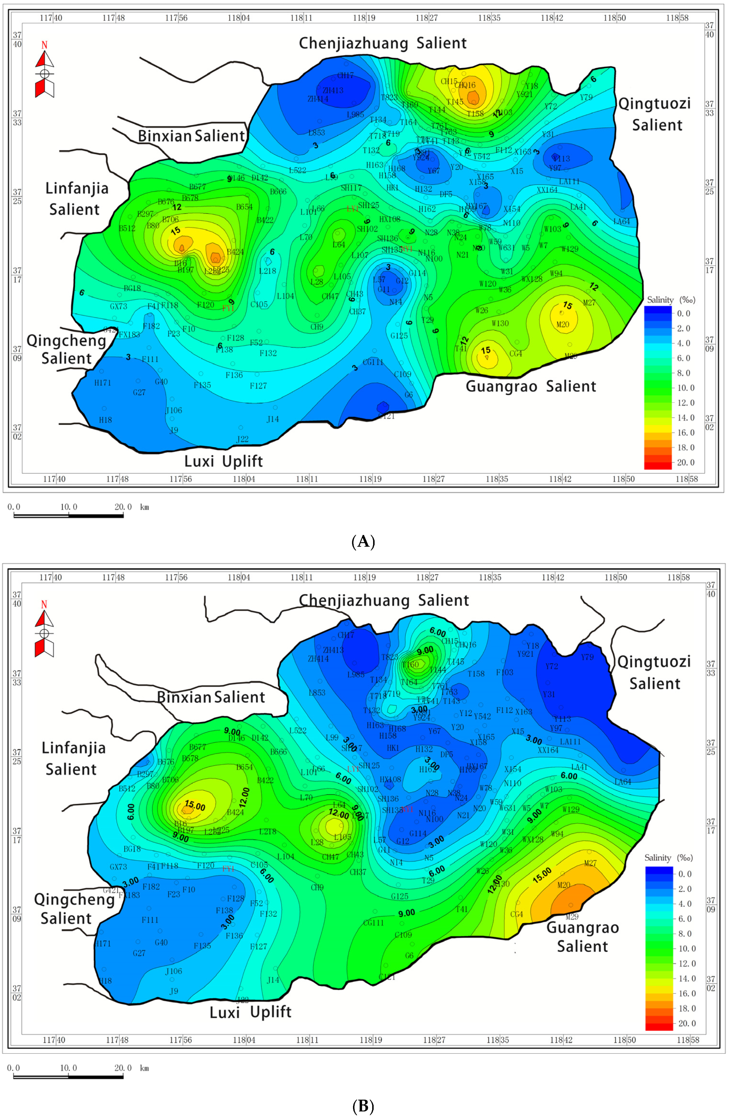
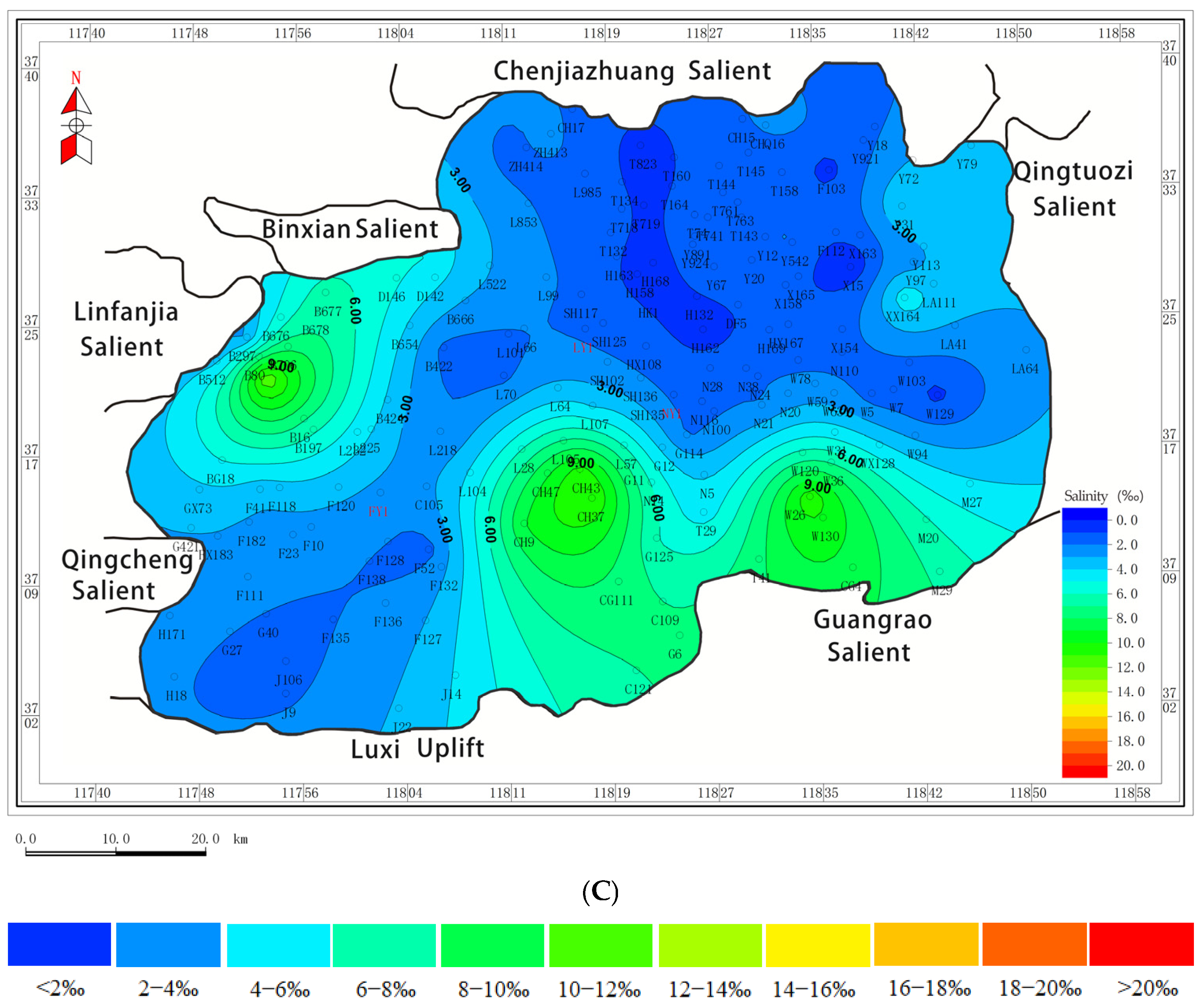
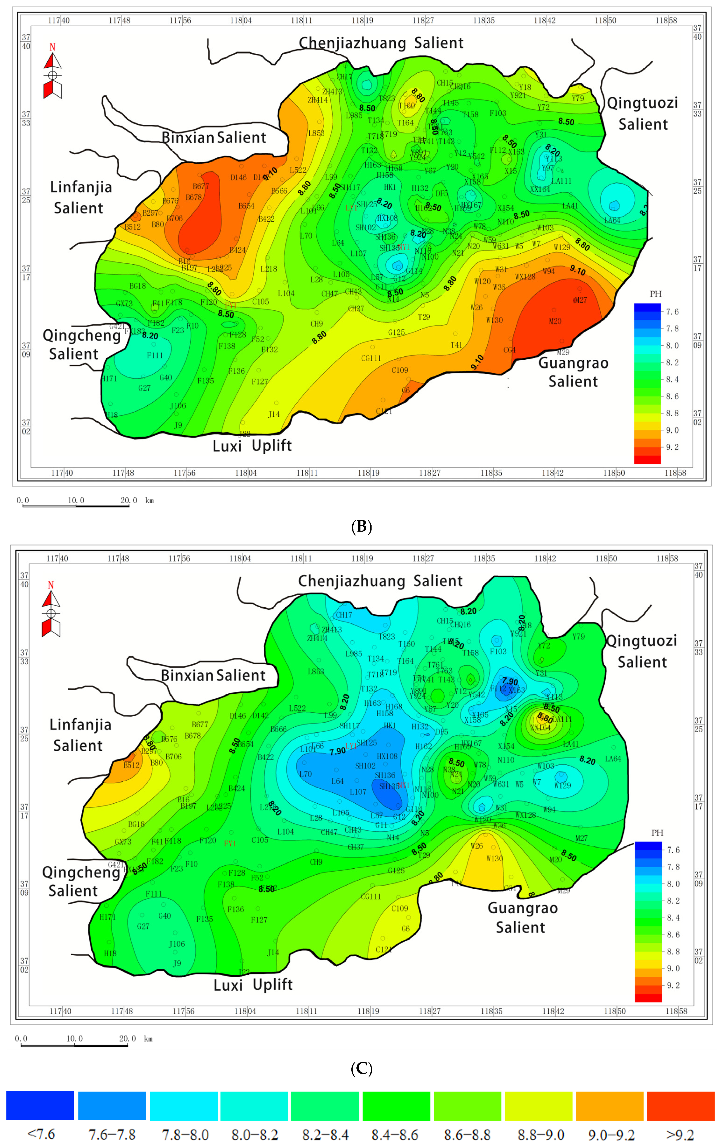
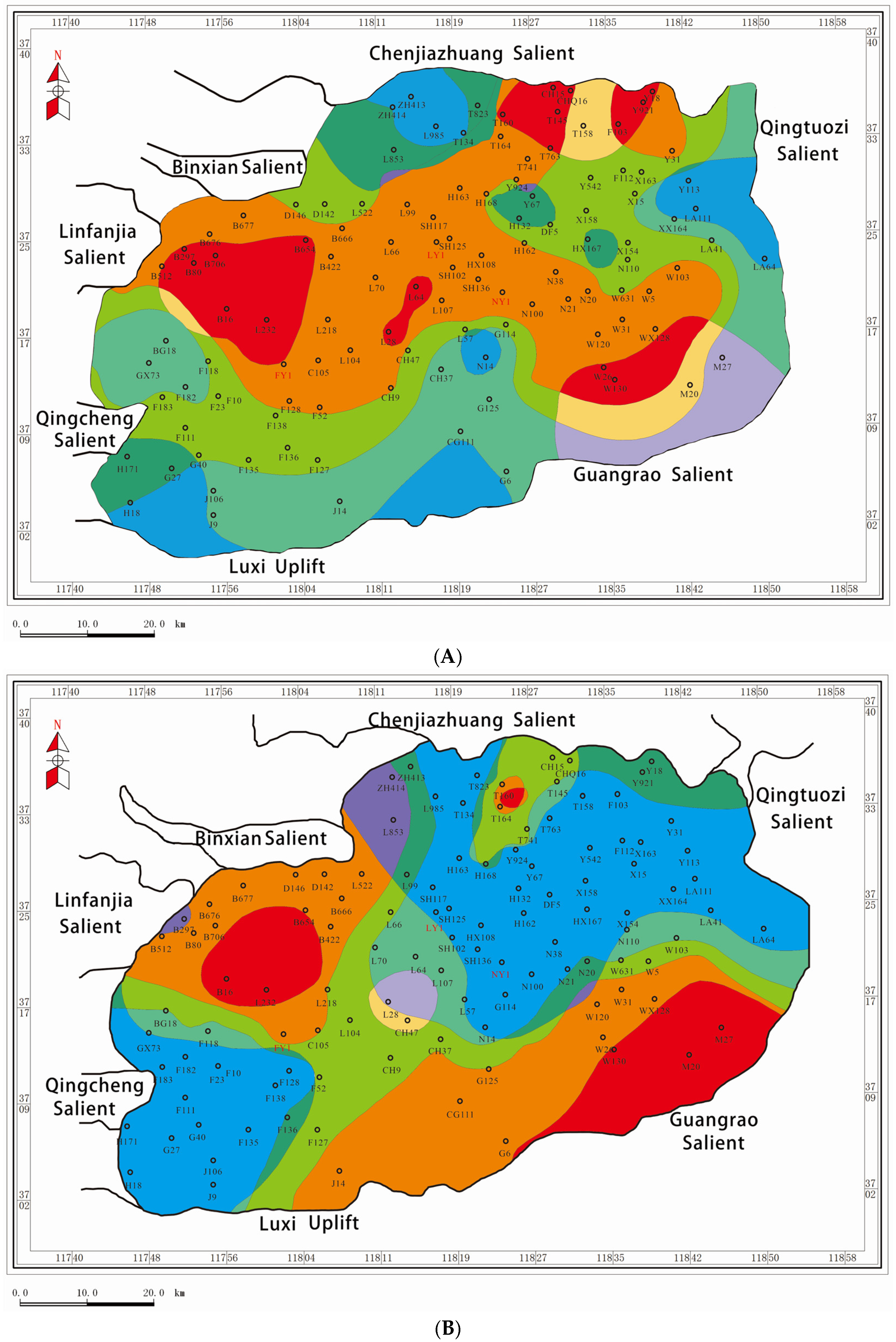
3.2. Environmental Zone and Characteristics

There are three sub-members with different characteristics in Es3, which are divided by the overlapping method.
In Es3L, it shows a strip characterized by “high in the middle and low on both sides”, and the environment is saline alkaline or brackish alkaline (Figure 7A). The areas with high value are distributed in a strip from the southeast of the Linfanjia Uplift to the southeast of the basin and the southern part of the Chenguanzhuang Uplift, accounting for 40% of the basin. They are surrounded by zones with medium and low value. The regions with high salinity and low pH and low salinity and high pH are rarely distributed and only exist in a small area in the north of Lijin Sub-Sag. This reflects that the water in the central area of the lake basin is salty and reductive.
In Es3M, it shows a strip characterized by “high on both sides and low in the middle”, and the environment consists of brackish water and is a neutral environment (Figure 7B). The northwest and southeast of the basin are areas with high salinity and pH values, which are specifically distributed in the Linjifan Uplift, the southeast of the Binxian Uplift, and the Chunhua areas. In the center of the basin is the middle and low value area, which extends from the southeast of Qingcheng Uplift to the northeast direction to Qingtuozi Uplift. This area is located in the slope break zone of the syngenetic fault that controls the central uplift. The fault activity results in the active flow body of the surrounding source, which reduces the pH value of the sedimentary aqueous medium.
In Es3U, it shows the characteristics of “high on both sides and low in the middle”, which is similar to Es3M. It is a neutral to weakly acidic environment of freshwater, with a significant decrease in salinity and pH (Figure 7C). The areas with low values are significantly expanded, which are distributed in the eastern part of the sag, the south of Chenjiazhuang Uplift, the central uplift, and part of the southwest Jinjia area, accounting for nearly 80% of the basin. The high-value areas are still mainly distributed in the northwest Linfanjia Uplift, the southern margin of Chenjiazhuang Uplift, and the southeast Wangjiagang area, which is opposite to the low-value areas. It is obviously controlled by the development degree of the river delta in Es3U. Within its influence range, the aqueous medium parameters show a low value characteristic.

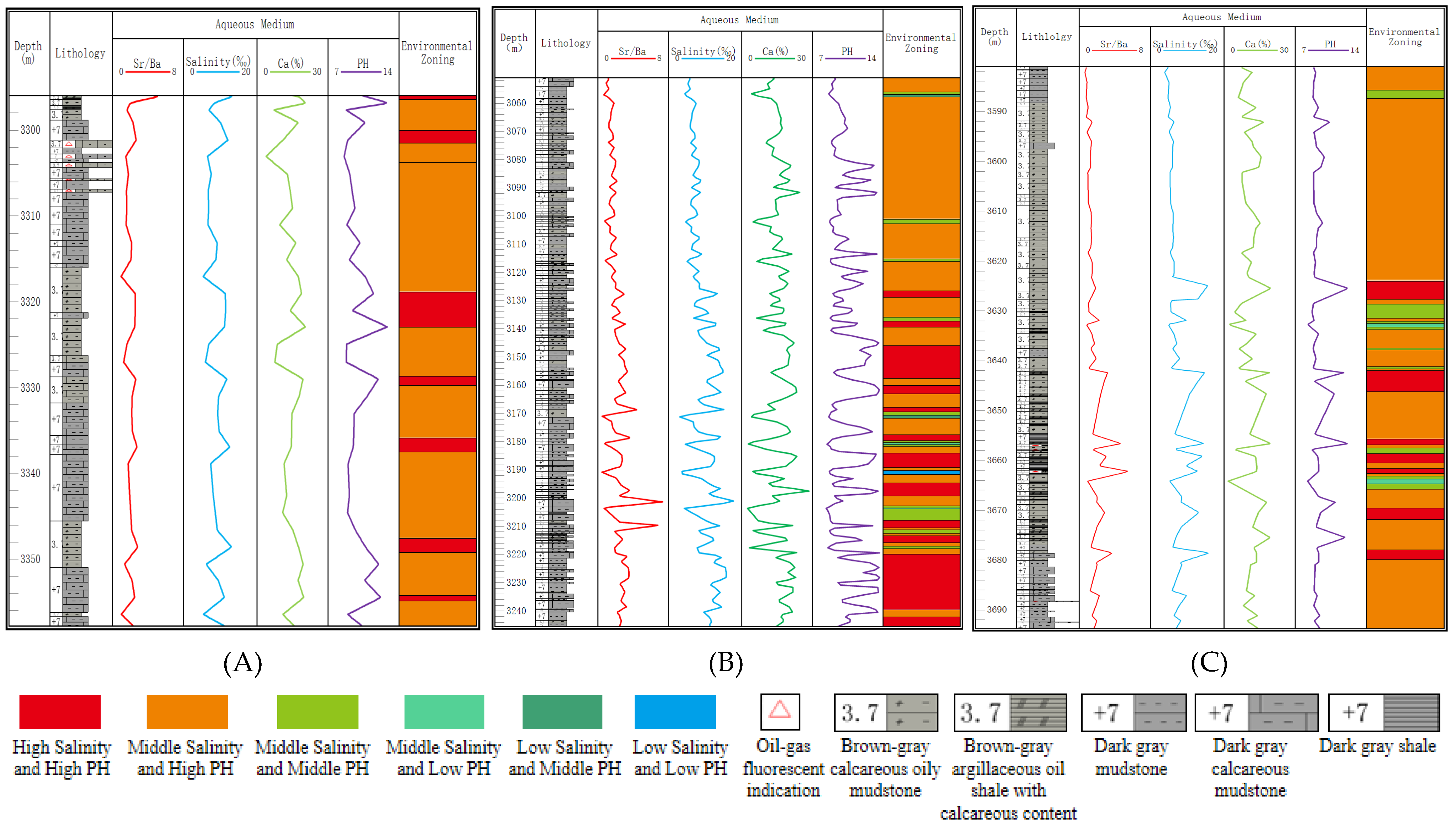
3.3. Division Characteristics of Key Coring Wells

As for the key coring wells, comparing the logging data, aqueous medium data, lithology data, organic matter data, carbonate rock data, etc., could divide the environment and analyze the vertical environmental response.
The environment of Es3L in Well NY1 is basically brackish water and alkaline, which accounts for about 80% of the total area. In the upper part of Es3L, the range of this kind of environment becomes larger, reflecting that the salinity of the upper part is lower and lower. The Sr/Ba, Ca, and Total Organic Carbon (TOC) values of these zones are high, and the lithofacies are mainly carbonate mudstone. This is consistent with the results of previous studies. From Es3L to Es3M, the study area gradually developed from an “under-compensated closed lake” to a “flow-able lake” (Figure 8A). The saline alkaline condition accounts for 15% of Es3L with high Sr/Ba, Ca, and TOC. The lithology is mainly layered mudstone. In Es4, the basin was in the depression stage, and the lake shrank in a hot and dry climate.
Less allochthonous sediment leads to higher salinity in the lake, which presents as a strongly alkaline environment. The saltwater alkaline environment in Es3 reflects the good inheritance from Es3L to Es3U. In addition, the occasional moderately acidic and alkaline environment of brackish water appeared at a depth from 3302 m to 3304 m, reflecting the beginning of water dilution and an increase in allochthonous sediments.
The environment division of Es3L in FY1 and LY1 is similar to NY1 (Figure 8B,C). There is a weakly acidic environment of brackish water in LY1. This reflects that the lake water is desalinated, and the allochthonous sediments are increased. On the other hand, it indicates that the offshore distance of LY1 is closer than NY1. Compared with the first two wells, the saline water and alkaline environment account for the largest proportion in well FY1, reflecting that well FY1 is closest to the lake center, with the strongest salinity and reducibility. There are three extra kinds of zones, including brackish water and neutral environment, fresh water and neutral environment, and fresh water and weakly acidic environment. These three zones are relatively thin in the vertical direction, accounting for about 10% of Es3. The vertical evolution characteristics of the three key wells are fairly consistent with the plane distribution characteristics of the same period.

4. Discussion

Compared with conventional oil and gas reservoirs, the enrichment of shale oil lacks conventional cap rocks, traps, and migration processes, resulting in significant control over lithology and lithofacies. This article starts from the ash content of the third member of the Shahejie Formation and combines well logging data and geochemical testing data to analyze the distribution of carbonate reservoirs in different water medium environments.

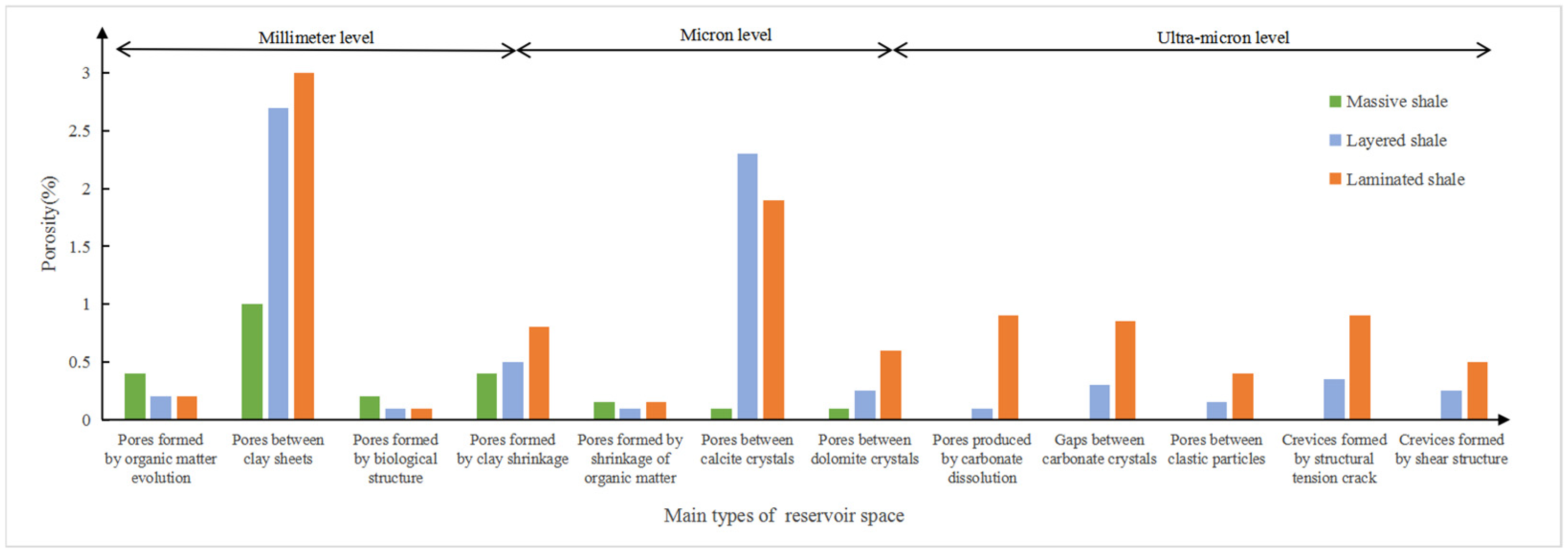
4.1. Advantage Storage Space of Shale Oil Reservoirs

The main shale oil reservoir spaces in Es3L of Zhanhua Sag near the research area include organic matter pores, intergranular pores, dissolution pores, structural fractures, and bedding fractures [35]. In the Jiyang Depression, the pores less than 50 nm are mainly provided by calcite dissolution pores. The pores ranging from 50 nm to 2 μm are provided by intergranular pores. The pores greater than 2 μm are provided by bedding and structural fractures (Figure 9). The larger contribution rate of porosity is intergranular pores, mainly derived from intergranular pores of clay minerals and carbonate minerals, such as calcite intergranular pores and dolomite intergranular pores.
Organic-rich mud shale and mudstone are concentrated in Es3. There is also a large number of laminated carbonate rocks in the form of intermediate shale. The main carbonate material is calcite, the content of which is up to 78%, and the average is 37.5%. The maximum dolomite content is 76%, and the average is 18.3%. Among them, the common reservoir space types of laminated shale and sandstone inter-layer combination are mainly inter-granular pores and dissolution pores, with a large pore size range and high macropore proportion. The porosity of the sandstone interlayer mainly ranges from 4.7% to 21.9%, while the average porosity of the shale matrix and interlayer is 13.14% and 11.57% [36]. The carbonate mineral interlayer is an important influencing factor for the effective reservoir space in Dongying Sag, and its development is closely related to the water environment.

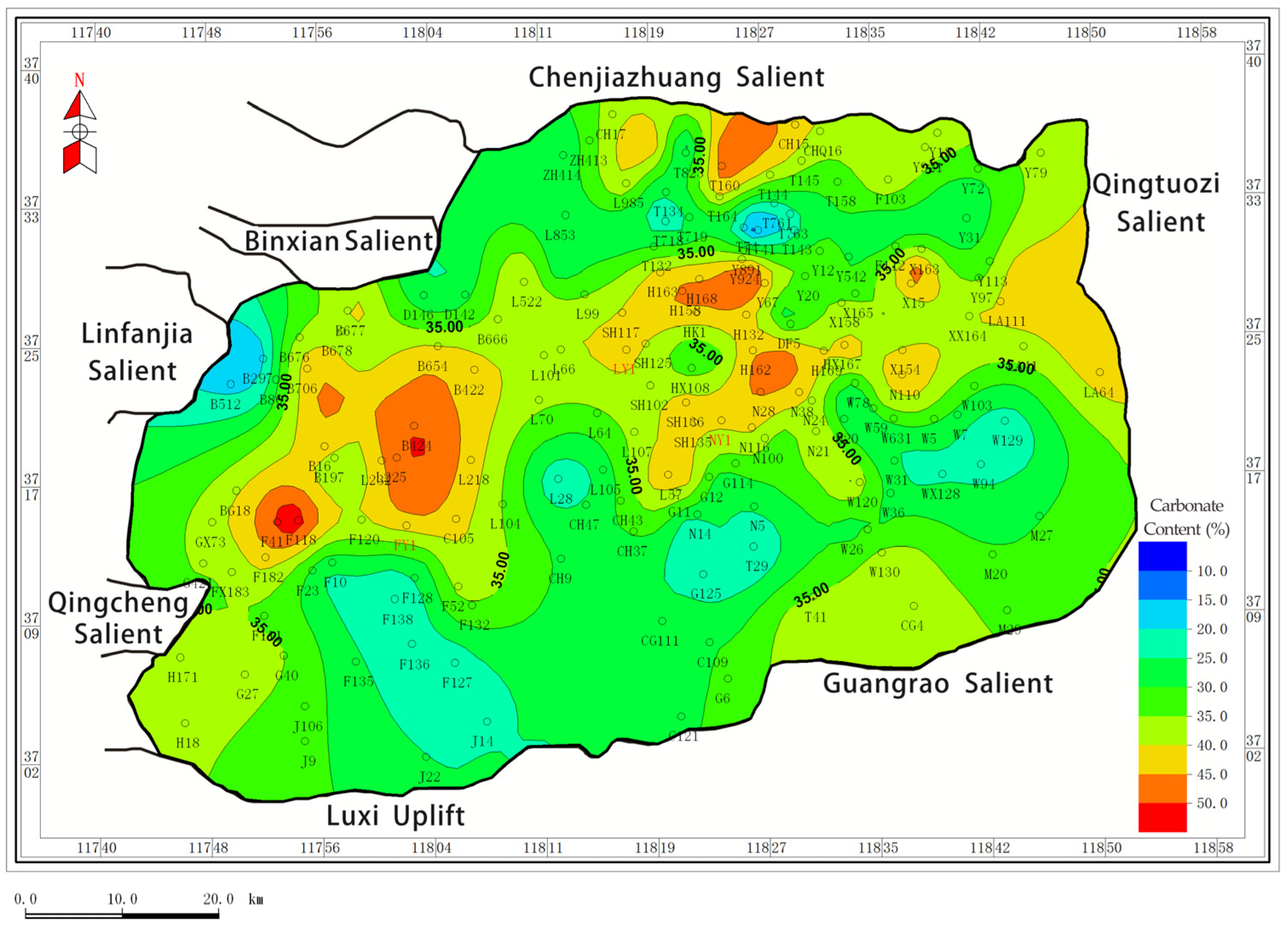
4.2. Prediction of Favorable Zones for Shale Oil Carbonate Reservoirs

There are many factors in the evaluation of shale oil reservoir characteristics, and the evaluation is mainly centered on oil production potential, reservoir capacity, reservoir transformation conditions, and shale oil movability. With the abundant thick-layer mudstone and source rock resources in the study area, the key factors restricting the favorable area of shale oil in the study area are reservoir properties, compressibility, and mobility. The interlayers not only produce oil themselves but also serve as important oil extraction channels for shale oil. The minerals in the interlayer are mainly carbonate minerals, which are brittle minerals and improve the compressibility of shale oil reservoirs. The development of the interlayer naturally increases the oil content, constituting an important reservoir space in the study area. This study takes carbonate rock interlayers as a bridge. The changes in the aqueous medium environment have affected the development and distribution of carbonate rock interlayers in the study area, thereby influencing the development of shale oil reservoirs.
Artificial synthesis experiments of dolomite and studies on a large number of recent dolomite sediments indicate that most dolomite forms under conditions of intense evaporation, high salinity, high Mg/Ca ratio, relatively high pH values, reducing environments, and higher temperatures [37]. Only such conditions favor the precipitation of dolomite from water by overcoming kinetic and thermodynamic barriers.
The overall environment of Es3L is a saline-salinity alkaline environment, which is conducive to the development of carbonate rocks. It focuses on the quantitative study of the ash content of the Es3L. According to the fitting formula, the ash content of Es3L is calculated, and the plane distribution map is drawn (Figure 10). The value of carbonate content in Es3L is from 11.39% to 66.25%, with an average of 36.16%. On the plane, the high-value areas with carbonate content greater than 35% are mainly distributed in the central depression zone, especially in the southeast of Linfanjia Uplift, the northeast of Lijin Sub-Sag, and the northwest of Niuzhuang Sub-Sag. The carbonate content in some wells reaches 60%.
The favorable areas of shale oil carbonate reservoirs in Es3 follow through the environmental characteristics of the aqueous medium and, combined with the research results of the previous researchers, it is hypothesized that the favorable areas of the shale oil carbonate reservoirs in Es3 are high salinity–high pH, high salinity–medium pH, and medium salinity–high pH, and are organic-rich and have a high carbonate content.
Based on the thick mudstone layers and high-quality source rocks in the study area (Figure 11), the abundant lamellar carbonate mineral intercalations provide sites for hydrocarbon migration and accumulation, allowing hydrocarbons to be stored during the primary migration phase. On the other hand, secondary pores formed by the dissolution of carbonate minerals are conducive to reservoir reformation. A large number of lamellar carbonate minerals are developed in the favorable areas with the carbonate content remaining above 35%, which provides a place for the migration and accumulation of hydrocarbons. The favorable reservoir areas of Es3 are gradually reduced from the bottom to the top, and the favorable areas are concentrated in Es3L. It is mainly distributed in the west of the Lijin Sub-Sag, which is in the intersection area of the east side of the Linfanjia Uplift and the south side of the Binxian uplift, the northeast of the Lijin Sub-Sag, and the northern gentle slope area of Guangrao.
By comparing the free resources of shale oil, it is found that the areas with higher total resource intensity are distributed in the west of Lijin Sub-Sag, while the areas with higher free resource intensity are distributed in the northeast of Lijin Sub-Sag (Figure 12) [38]. This is consistent with the predicted results, and the partitions with high salinity–high pH and high salinity–medium pH are located in the area with a good evaluation of free-phase shale resources.
Combined with the analysis of structural location, it is predicted that the favorable areas of high salinity–high pH and high salinity–medium pH belong to the structural slope area. The enrichment of various types of shale oil in the slope area is a very valuable reserve direction for the effective exploration and development of shale oil [39].
First, the deep slope break zone with buried depth from 3200 to 3400 m in the slope area not only has the development conditions of matrix shale oil but also develops rich pre-delta turbidite sandstone interlayers, which is also a favorable environment for the development of interlayer shale oil. Secondly, the middle part of the slope area with buried depth from 2500 m to 3200 m is the most favorable mixed area of high-quality oil shale, thin sandstone, and thin-layer carbonate rock, and it is also the area where the deformation of the basin is adjusted and the faults and fractures are widely developed. Especially in the buried depth range of from 2600 m to 3300 m, the brittle oil shale series is not only rich in authigenic oil sources but also often captures the light oil that migrates laterally from the deep depression area, which is very conducive to the formation of vertically superimposed, horizontally connected self-sourced, other-sourced, mixed-sourced high-yield fractured shale oil. Thirdly, the mid-slope zone usually has a shallower buried depth, lower drilling and completion costs, and higher natural productivity. Some wells do not even need to be fractured. Even if the productivity is not ideal, the fracturing can be slightly successful. Therefore, although the prediction of the fracture zone is difficult, the overall risk of shale oil exploration in the mid-slope zone is not high, and even the comprehensive benefits are comparable to those in the deep-lying areas.
This provides a novel perspective on shale oil exploration through lacustrine environmental zonation. The core idea is to draw on the concept of fine division of lake sedimentary systems and combine the study of the heterogeneity of shale oil reservoirs with the evolution parameters of lake environments, thereby optimizing the prediction of exploration target areas and the identification of sweet spots. The limitation of this method is that different parameters need to be selected for fitting based on the characteristics and data of different study areas, which requires a certain data foundation. The hydrodynamic conditions, paleosalinity, pH value, and biological activity in different zones vary greatly. By analyzing the correlation between different parameters and favorable reservoirs, the development characteristics of favorable reservoirs can be predicted.

5. Conclusions

  • Establishing a classification scheme for the aqueous medium environment of Es3 is based on the salinity boundaries of 4‰ and 11‰ and pH boundaries of 8.65 and 8.85 for defining high, medium, and low levels. There are nine kinds of zones theoretically proposed by the superposition method to describe the salinity and pH.
  • Es3L is dominated by areas with high salinity–middle pH and middle salinity–high pH, which are rich in carbonate, presenting a saline–brackish alkaline environment. The salinity and pH in Es3M decreased, mainly in middle salinity–middle pH and low salinity–middle pH areas, which were in the brackish neutral environment. Es3U is mainly characterized by low salinity and low pH conditions.
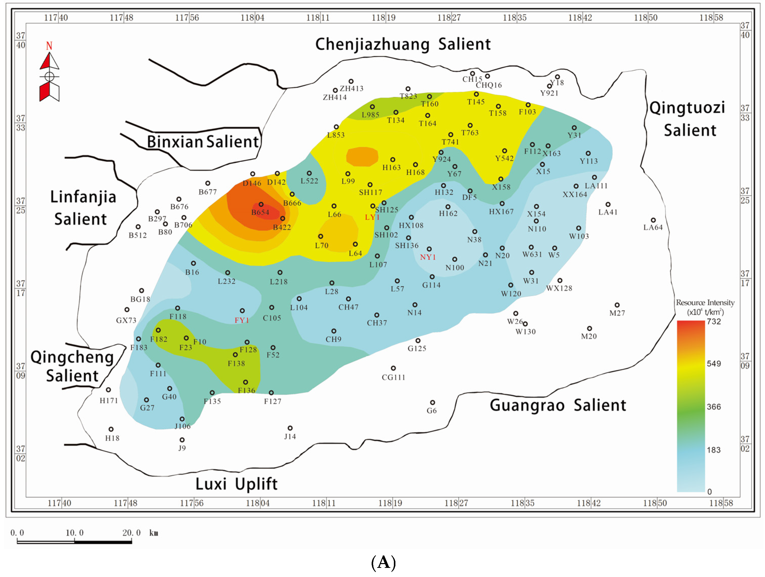
  • The abundant laminar carbonate mineral interbeds serve as effective reservoir spaces. The limestone content in zones with high salinity–middle pH, middle salinity–high pH, and middle salinity–high pH mostly remains above 35%, suggesting these areas as favorable for shale oil reservoirs in the Es3 Member of the Dongying Sag. It is concentrated in the central part of Es3L, the western and northeast parts of the Lijin Sub-Sag, and the northern gentle slope of the Guangrao. The first two environmental partitions are located in the structural slope area, which is a valuable reserve target for the exploration and development of shale oil.

Author Contributions

Conceptualization, H.Z. and H.W.; methodology, H.Z. and N.M.; writing—original draft preparation, H.Z.; writing—review and editing, H.Z., H.W. and N.M. All authors have read and agreed to the published version of the manuscript.

Funding

This research received no external funding.

Data Availability Statement

Data are contained within the article.

Acknowledgments

The completion of this paper has benefited from support and assistance from various quarters. First and foremost, I extend my heartfelt gratitude to Hongliang Wang, the corresponding author, for his invaluable guidance and advice during the research design and idea organization stages. Furthermore, I am grateful to Nana Mu for her assistance with data analysis. Discussions with them have been immensely beneficial to me. Lastly, I would like to thank the editors and reviewers of Energies for dedicating their valuable time to reviewing my article, as their comments and suggestions have significantly enhanced its quality. Once again, I express my sincerest thanks to all those who have helped and supported me.

Conflicts of Interest

The authors declare no conflicts of interest.

Abbreviations

The following abbreviations are used in this manuscript:
Es3The third member of the Shahejie Formation
Es3LThe lower part of the third member of the Shahejie Formation
Es3MThe middle part of the third member of the Shahejie Formation
Es3UThe upper part of the third member of the Shahejie Formation
Es4UThe upper part of the fourth member of the Shahejie Formation
TOCTotal Organic Carbon

References

  1. Zou, C.N.; Ma, F.; Pan, S.G.; Zhang, X.S.; Wu, S.T.; Fu, G.Y.; Wang, H.J.; Yang, Z. Formation and distribution potential of global shale oil and the developments of continental shale oil theory and technology in China. Earth Sci. Front. 2023, 30, 128–142. [Google Scholar]
  2. Salygin, V.; Guliev, I.; Chernysheva, N.; Sokolova, E.; Toropova, N.; Egorova, L. Global shale revolution: Successes, challenges, and prospects. Sustainability 2019, 11, 1627. [Google Scholar] [CrossRef]
  3. Kuang, L.C.; Hou, L.H.; Yang, Z.; Wu, S. Key parameters and methods of lacustrine shale oil reservoir characterization. Acta Pet. Sin. 2021, 42, 1–14. [Google Scholar]
  4. Zhao, X.Z.; Pu, X.G.; Jiang, W.Y.; Zhou, L.; Jin, F.; Xiao, D.; Fu, L.; Li, H. An exploration breakthrough in Paleozoic petroleum system of Huanghua Depression in Dagang Oilfield and its significance, North China. Pet. Explor. Dev. 2019, 46, 651–663. [Google Scholar] [CrossRef]
  5. Fu, J.H.; Li, S.; Guo, Q.; Guo, W.; Zhou, X.; Liu, J. Enrichment condition and favorable area optimization of continental shale oil in Ordos Basin. Acta Pet. Sin. 2022, 43, 1702. [Google Scholar]
  6. Sun, L.; Liu, H.; He, W.; Li, G.; Zhang, S.; Zhu, R.; Jin, X.; Meng, S.; Jiang, H. An analysis of major scientific problems and research paths of Gulong shale oil in Daging Oilfield, NE China. Pet. Explor. Dev. 2021, 48, 453–463. [Google Scholar] [CrossRef]
  7. He, W.; Meng, Q.; Feng, Z.; Zhang, J.; Wang, R. In-situ accumulation theory and exploration & development practiceof Gulong shale oil in Songliao Basin. Acta Pet. Sin. 2022, 43, 1–14. [Google Scholar]
  8. Li, G.; Zhu, R.; Zhang, Y.; Chen, Y.; Cui, J.; Jiang, Y.; Wu, K.; Sheng, J.; Xian, C.; Liu, H. Geological characteristics, evaluation criteria and discovery significance of Paleogene Yingxiongling shale oil in Qaidam Basin, NW China. Pet. Explor. Dev. 2022, 49, 18–31. [Google Scholar] [CrossRef]
  9. Kuang, L.C.; Dong, D.; He, W.Y.; Wen, S.; Sun, S.; Li, S.X.; Qiu, Z.; Liao, X.W.; Li, Y.; Wu, J.; et al. Geological characteristics and development potential of transitional shale gas in the east margin of the Ordos Basin, NW China. Pet. Explor. Dev. 2020, 47, 435–446. [Google Scholar] [CrossRef]
  10. Liu, H.M.; Wang, Y.; Yang, Y.H.; Zhang, S. Sedimentary Environment and Lithofacies of Fine-Grained Hybrid Sedimentary in Dongying Sag: A Case of Fine-Grained Sedimentary System of the Es4. Earth Sci. 2020, 45, 3543–3555. [Google Scholar]
  11. Yang, W.; Wang, X.; Ding, J.; Wang, Y. Characteristics and control factors of fine-grained sedimentary rock lithofacies in Bonan subsag. J. China Univ. Min. Technol. 2017, 46, 365–374. [Google Scholar]
  12. Zhang, Q.; Zhu, X.; Li, C.; Qiao, L. Classification and quantitative characterization of microscopic pores in organic-rich shale of the Shahejie Formation in the Zhanhua Sag, Bohai Bay Basin. Oil Gas Geol. 2014, 35, 286–294. [Google Scholar]
  13. Zhang, S.; Liu, H.M.; Zhang, P.F.; Li, L.J.; Liu, X.J.; Song, X.Q.; Wei, X.L.; Wang, Y.; Wang, W.Q. Geological characteristics of shale oil enrichment in Niuzhuang sag, Dongying depression. J. China Univ. Min. Technol. 2022, 51, 1138–1151. [Google Scholar]
  14. Hao, Y.; Chen, F.; Zhu, J.; Zhang, S. Reservoir space of the Es33-Es41 shale in Dongying Sag. Int. J. Min. Sci. Technol. 2014, 24, 425–431. [Google Scholar] [CrossRef]
  15. Zhang, S.; Chen, S.; Tan, M.; Zhang, Y.; Sun, B.; Gong, W.; Hu, Z.; Hou, Z. Characterization of sedimentary microfacies of shale in the lower third sub-member of Shahejie Formation, western Dongying sag. Acta Pet. Sin. 2014, 35, 633–645. [Google Scholar]
  16. Wang, Y.; Song, G.Q.; Liu, H.M.; Jiang, X.F.; Hao, X.F.; Ning, F.X.; Zhu, S.D.; Lin, L. Main control factors of enrichment characteristics of shale oil in Jiyang depression. Pet. Geol. Recovery Effic. 2015, 22, 20–25. [Google Scholar]
  17. Sun, C.; Yao, S.; Li, J.; Liu, B. The Characterization of Shale Oil Reservoir in Dongying Sag. Geol. Rev. 2016, 62, 1497–1510. [Google Scholar]
  18. Bai, C.Y. The Genesis of Laminar Carbonates from Jiyang Sub-Basin and Their Implicate for Shale Oil Accumulation; China University of Gcosciences (Beijing): Beijing, China, 2019. [Google Scholar]
  19. Burton, G.R.; Woolf, K.; Sullivan, B. Lacustrine depositional environments in the Green River Formation,Uinta Basin: Expression in outcrop and wire line logs. AAPG Bull. 2014, 98, 1699–1715. [Google Scholar] [CrossRef]
  20. Scherer, C.M.S.; Goldberg, K.; Bardola, T. Facies architecture and sequence stratigraphy of an early post-rift fluvial succession,Aptian Brabalha Formation,Araripe Basin,northeastern Brazil. Sediment. Geol. 2015, 322, 43–62. [Google Scholar] [CrossRef]
  21. Merkel, A.; Fink, R.; Littke, R. High pressure methane sorption characteristics of lacustrine shale from the Midland Valley Basin, Scotland. Fuel 2016, 182, 361–372. [Google Scholar] [CrossRef]
  22. Moradi, A.V.; Sari, A.; Akkaya, P. Paleoredox reconstruction of biturninous shales from the Miocene Hancili Formation, cankiri-corum Basin, Turkey: Evaluating the role of an oxia in accumulation of organic-rich shales. Mar. Pet. Geol. 2016, 78, 136–150. [Google Scholar] [CrossRef]
  23. Yang, T.; Cao, Y.; Friis, H.; Wang, Y.; Zhou, L. Diagenetic evolution and chemical changes of deep-water mudstones of Shahejie Formation in the Dongying Sag, Jiyang Depression, Eastern China. Mar. Pet. Geol. 2018, 93, 14–32. [Google Scholar] [CrossRef]
  24. Sun, C.; Yao, S.; Li, J.; Liu, B. Characteristics of Mesoporous in shale oil reservoirs by Small Angle X-ray Scattering Method. Geol. J. China Univ. 2017, 24, 715–724. [Google Scholar]
  25. Zou, C.; Yang, Z.; Cui, J.; Zhu, R.; Hou, L.; Tao, S.; Yuan, X.; Wu, S.; Lin, S.; Wang, L.; et al. Formation mechanism,geological characteristics and development strategy of nonmarine shale oil in China. Pet. Explor. Dev. 2013, 40, 14–26. [Google Scholar] [CrossRef]
  26. Wang, G.M.; Lin, G.S. Eogene paleoclimate zone study in the Jiyang depression. Bulletin of Mineralogy. Petrol. Geochem. 2012, 31, 505–509. [Google Scholar]
  27. Liu, H.M.; Zhang, S.; Bao, S.Y.; Fang, Z.; Yao, S.; Wang, Y. Geological characteristics and effectiveness of the shaleoil reservoir in Dongying sag. Oil Gas Geol. 2019, 40, 512–523. [Google Scholar]
  28. Teng, J.B.; Liu, H.M.; Qiu, L.W.; Zhang, S.P.; Fang, Z.W.; Li, B.; Zhang, S.; Miao, Z.W. Characteristics and influencing factors of shale oil reservoir space in Paleogene shale of Dongying Sag. Earth Sci. 2022. [Google Scholar]
  29. Fang, Z.W.; Zhang, S.P.; Liu, H.M. Bedding structure characteristics and the storage controlling factors of mud-shale in Upper Es4 to Lower Es3 Members in Jiyang Depression. Pet. Geol. Recovery Effic. 2019, 26, 101–108. [Google Scholar]
  30. Wang, G.M.; Xiong, Z.H.; Zhang, J.; Fu, Y. The correspondence between the aragonite content of Palaeogene shale and the thermal evolution of source rocks in Jiyang depression. Acta Pet. Sin. 2017, 38, 855–862. [Google Scholar]
  31. Wang, Y.; Liu, H.; Song, G.; Hao, X.; Zhu, D.; Zhu, D.; Ding, J.; Yang, W.; Yin, Y. Carbonate genesis and geological significance of shale hydrocarbon in lacustrine facies mud shale: A case study of source rocks in the upper sub-member of Member4 and lower sub-member of Member 3 of Shahejie Formation, Dongying sag. Acta Pet. Sin. 2017, 38, 1390–1400. [Google Scholar]
  32. Kong, X.X. Sedimentary Characteristics, Origin and Hydrocarbon Accumulation of Lacustrine Carbonate-Bearing Fine Grained Sedimentary Rocks; China University of Gcosciences (Beijing): Beijing, China, 2020. [Google Scholar]
  33. Wang, A.H.; Ye, S.Y.; Liu, J.K.; Ding, X.G.; Li, H.L.; Xu, N.C. Discrimination between Marine and Terrestrial Sedimentary Environments by the Selectively Extracted Sr/Ba Ratio: A case of sediments in the Yellow River Delta. ACTA Sedimentolocica Sin. 2020, 38, 1226–1238. [Google Scholar]
  34. Chen, C.Q. A Study on the Diagenesis of Paleogene System Based on Sequence Framework in DongYing Sag; China University of Gcosciences (Beijing): Beijing, China, 2006. [Google Scholar]
  35. Jiang, Z.; Li, T.; Gong, H.; Jiang, T.; Chang, J.; Ning, C.; Su, S.; Chen, W. Characteristics of low-mature shale reservoirs in Zhanhua sag and theirinfluence on the mobility of shale oil. Acta Pet. Sin. 2020, 41, 1587–1600. [Google Scholar]
  36. Zhang, S. Shale Oil Enrichment Elements and Geological Dessert Types in Jiyang Depression. Sci. Technol. Eng. 2021, 21, 504–511. [Google Scholar]
  37. Tian, J.C.; Lin, X.B.; Zhang, X.; Peng, S.; Yang, C.; Luo, S.; Xu, L. The genetic mechanism of shoal facies dolomite and its additive effect of Permian Qixia Formation in Sichuan Basin. Acta Petrol. Sin. 2014, 30, 679–686. [Google Scholar]
  38. Yu, T. Enrichment Characteristics and the Prediction of Favorable Target Areas of Shale Oil in Dongying Sag; China University of Petroleum (East China): Qingdao, China, 2018. [Google Scholar]
  39. Yu, Y.J.; Wang, H.Y.; Liu, D.X.; Zhao, Q.; Zheng, M.; Wang, S.J. Probing and Thinking on “Exploring Petroleum Inside Source Kitchen” of Continental Shale Oil Exploration—A Case Study of the First Member of Shahejie Formation in Qikou Sag, Bohai Bay Basin, China. J. Earth Sci. Environ. 2021, 43, 117–134. [Google Scholar]
Figure 1. Geological overview of the study area. ((A) Location of the Bohai Bay Basin in China; (B) the tectonic unit division of Bohai Bay Basin; (C) the tectonic unit division of Dongying sag and a south-to-north structural cross-section).
Energies 18 03086 g001
Figure 2. Correlation of salinity fitting equation. ((A) Exponential function; (B) linear function; (C) quadratic function; (D) sextic function).
Energies 18 03086 g002
Figure 3. Correlation of pH fitting equation. ((A) Exponential function; (B) linear function; (C) quadratic function; (D) cubic function).
Energies 18 03086 g003aEnergies 18 03086 g003b
Figure 4. The accuracy test for the fitting equation of carbonate mineral content.
Energies 18 03086 g004
Figure 5. Salinity plane division scheme of Es3 Dongying Sag ((A) Es3L:163 wells with valid data; (B) Es3M:156 wells; (C) Es3U:92 wells).
Energies 18 03086 g005aEnergies 18 03086 g005b
Figure 6. pH plane division scheme of Es3 in Dongying Sag ((A) Es3L; (B) Es3M; (C) Es3U).
Energies 18 03086 g006aEnergies 18 03086 g006b
Figure 7. Environmental division plan of Es3 ((A) Es3L; (B) Es3M; (C) Es3U).
Energies 18 03086 g007aEnergies 18 03086 g007b
Figure 8. Environmental division of well ((A) NY1; (B) FY1; (C) LY1).
Energies 18 03086 g008
Figure 9. Contribution of main reservoir space types to porosity of Paleogene shale reservoirs in Jiyang Depression.
Energies 18 03086 g009
Figure 10. Characteristics of carbonate content in Es3L.
Energies 18 03086 g010
Figure 11. Mudstone thickness of Es3.
Energies 18 03086 g011
Figure 12. Shale oil resource intensity of Es3L in Dongying Sag. ((A) Total resource intensity contour in Es3L; (B) free resource intensity contour in Es3L).
Energies 18 03086 g012aEnergies 18 03086 g012b
Table 1. The salinity fitting data of Well N38.
Sr/BaSalinity (‰)Sr/BaSalinity (‰)Sr/BaSalinity (‰)
0.543.750.330.744.2817.00
0.401.370.371.893.1315.00
0.643.914.0615.007.0519.00
0.603.582.259.506.5318.00
Table 2. The relationship between pH and Ca% in different locations.
LocationPHCa (%)LocationPHCa (%)
Qinghai Lake9.1112.00Yellow Sea8.402.09
Gahai Lake8.9310.50Yellow Sea8.182.29
Gahai Lake8.836.50Yellow Sea8.502.37
Yellow Sea8.543.71Erhai Lake8.081.21
Table 3. Pearson value of correlation between logging data and carbonate content.
WellSamplesGRSPACDENR25CNLCAL
FY18430.137−0.135−0.2250.0190.413−0.295−0.038
NY15170.1320.0200.035−0.0340.3770.261−0.055
LY1762−0.135−0.126−0.1730.1290.264−0.306−0.047
Disclaimer/Publisher’s Note: The statements, opinions and data contained in all publications are solely those of the individual author(s) and contributor(s) and not of MDPI and/or the editor(s). MDPI and/or the editor(s) disclaim responsibility for any injury to people or property resulting from any ideas, methods, instructions or products referred to in the content.

