Article

Geochemical Characteristics and Origin of Natural Gas in the Middle of Shuntuoguole Low Uplift, Tarim Basin: Evidence from Natural Gas Composition and Isotopes

1
College of Geosciences, China University of Petroleum (Beijing), Beijing 102249, China
2
National Key Laboratory of Petroleum Resources and Engineering, China University of Petroleum (Beijing), Beijing 102249, China
*
Authors to whom correspondence should be addressed.
Energies 2024, 17(17), 4261; https://doi.org/10.3390/en17174261
Submission received: 8 June 2024 / Revised: 27 July 2024 / Accepted: 15 August 2024 / Published: 26 August 2024
(This article belongs to the Section I3: Energy Chemistry)

Abstract

:
Multiple types of reservoirs, including volatile oil reservoirs, condensate gas reservoirs, and dry gas reservoirs, have been discovered in ultra-deep layers buried at depths greater than 7500 m. Understanding the genetic types of natural gas is of utmost importance in evaluating oil and gas exploration potential. The cumulative proved reserves of the super deep layer in the Shuntuoguole low uplift area of the Tarim Basin exceed 1 × 10⁸ t (oil equivalent). The origin, source, and accumulation characteristics of natural gas still remain a subject of controversy. By analyzing the composition and carbon isotope of natural gas, a detailed investigation was conducted to examine the unique geochemical and reservoir formation characteristics of the Ordovician ultra-deep natural gas within different fault zones in the middle region of the Shuntuoguole low uplift. It was determined that most of the natural gas in this area is displaying a characteristic of wet gas with a drying coefficient ranging from 0.41 to 0.99. The carbon isotope composition of methane in the gas reservoir shows relatively light values, ranging from −49.4‰ to −42‰. The carbon and hydrogen isotopes of the components are distributed in a positive order. The natural gas is oil type gas, which is derived from marine sapropelic organic matter and has a good correspondence with the lower Yuertusi formation. The maturity of natural gas in Shunbei No. 1 and No. 5 fault zones is about 1.0%, which is the associated gas of normal crude oil, while the maturity of No. 4 and No. 8 fault zones is higher than 1.0%, which is the mixture of kerogen pyrolysis gas and crude oil pyrolysis gas. The variations in the drying coefficient and carbon isotope composition of the natural gas provide evidence for the migration patterns within the Shuntuoguole low uplift central region. It indicates that the Shunbei No. 5 and No. 8 fault zones have likely migrated from south to north, while the No. 4 fault zone has migrated from the middle to both the north and south sides. These migration patterns are primarily controlled by high and steep strike-slip faults, which facilitate the vertical migration of natural gas along fault planes. Consequently, the gas accumulates in fractured and vuggy reservoirs within the Ordovician formation.

1. Introduction

The Tarim Basin, located in western China, is a significant region for oil and gas resources [1,2,3]. It is characterized by complex structural conditions and abundant oil and gas reserves. China has made remarkable advancements in the exploration of deep and ultra-deep carbonate rock formations within the Tarim Basin. A series of oil and gas fields in Tahe and Tazhong developed on carbonate paleo uplift and paleo slope have been found. These findings have expanded the scope of oil and gas exploration and have contributed to the increase in resource reserves within the basin. The Shunbei oil and gas field is located on the Shuntuoguole low uplift, distinct from other types of reservoirs such as carbonate hills, biological reefs, and karst fractures. It is formed by multiple stages of strike-slip fault movements and the transformation of buried fluids, resulting in a unique fault-controlled fracture reservoir [4].
The reservoir is predominantly found at depths greater than 7200 m and shows characteristics such as irregular morphology and pronounced changes in physical properties. Notably, the ongoing drilling operations in the Shunbei No. 4 and No. 5 fault zones have encountered multiple “thousand-ton wells” with an impressive production capacity exceeding 12 × 106 tons oil equivalent [5]. These significant discoveries not only confirm the reservoir’s considerable geological reserves but also unveil its vast potential for exploration.
Shuntuoguole low uplift, situated in the heart of the Tarim Basin, is in close proximity to the Tahe Oilfield and is renowned for its abundant oil and gas resources [6]. The Shuntuoguole low uplift strike-slip fault exhibits significant differences in the geochemical characteristics of natural gas. These differences can be observed among different faults and even within different segments in the same fault. Variations in content, relative density, dryness coefficient, and carbon isotope composition of both hydrocarbon and non-hydrocarbon gases are notable [7]. The oil and gas fluid properties in the central region of the Shuntuoguole low uplift exhibit a high level of complexity, encompassing a wide range of types such as normal crude oil, light oil, condensate oil, wet gas, dry gas, and more. This diversity signifies the presence of various reservoir types, different organic matter compositions and maturity levels, and underscores the intricate processes involved in the accumulation of oil and gas resources in the area [8].
The carbon isotopes of natural gas are crucial for studying its types and origins [9,10]. In nature, carbon has two stable isotopes: 12C and 13C, which have natural abundances of 98.89% and 1.11%, respectively. The carbon isotope composition is denoted as δ13C. This article follows the international PDB standard for measurements.
δ C 13 = C s a m p l e 13 C s a m p l e 12 C S t a n d a r d 13 C S t a n d a r d 12 1 × 1000
As shown in the formula, when 13C is enriched, the δ13C value becomes positive; otherwise, it is negative [11]. In nature, aside from heavy carbonates that are rich in 13C, most substances are typically enriched in the lighter isotope 12C, resulting in predominantly negative δ13C values. During photosynthesis in the natural carbon cycle, the chemical bonds of light isotope molecules are more readily broken, leading to the preferential incorporation of light isotopes into organic matter. As a result, natural gas and petroleum are often enriched in 12C, which is reflected in their negative δ13C values.
Luo Mingxia et al. [12] suggest significant differences in the geochemical characteristics of crude oil from different layers in Shunbei. They propose that the Silurian and Ordovician crude oil stems from Cambrian source rocks but were formed at different stages. Similarly, Gu Rong et al. [13] conclude that the oil and gas reserves in the Shunbei No. 1 fault are homologous and are sourced from the Lower Cambrian source rocks. Wang Tieguan et al. [14] have conducted research suggesting that the natural gas found on the southern gentle slope of Shuntuoguole is dry gas and was formed during the late Himalayan period. However, Yunlu’s [15] study proposes an alternative viewpoint, suggesting that the natural gas in the area is kerogen cracking gas. On the other hand, Ma Anlai et al. [16,17] put forth the belief that the natural gas is a mixed gas, while emphasizing that the oil and gas reservoir has not been invaded by gas. Consequently, varying perspectives persist regarding the origin, source, and reservoir characteristics of the Ordovician ultra-deep natural gas within the research area. Currently, research efforts primarily concentrate on the northern and southern gentle slopes of Shuntuoguole, while relatively less attention has been given to the central region of low uplifts.
This article focuses on the investigation of Ordovician ultra-deep natural gas in the central part of the Shuntuoguole low uplift. It aims to systematically organize and analyze the natural gas composition and isotopic characteristics, taking into account the regional tectonic evolution, and the latest exploration outcomes. By conducting a comprehensive comparison and analysis of the geochemical features and reservoir formation characteristics of Ordovician ultra-deep natural gas in different fault zones, the study intends to provide valuable insights for the exploration of Ordovician oil and gas in the central region of the Shuntuoguole low uplift. Through this research, a better understanding of the origin and properties of the ultra-deep natural gas in the area can be achieved, thereby facilitating effective exploration and resource evaluation efforts.

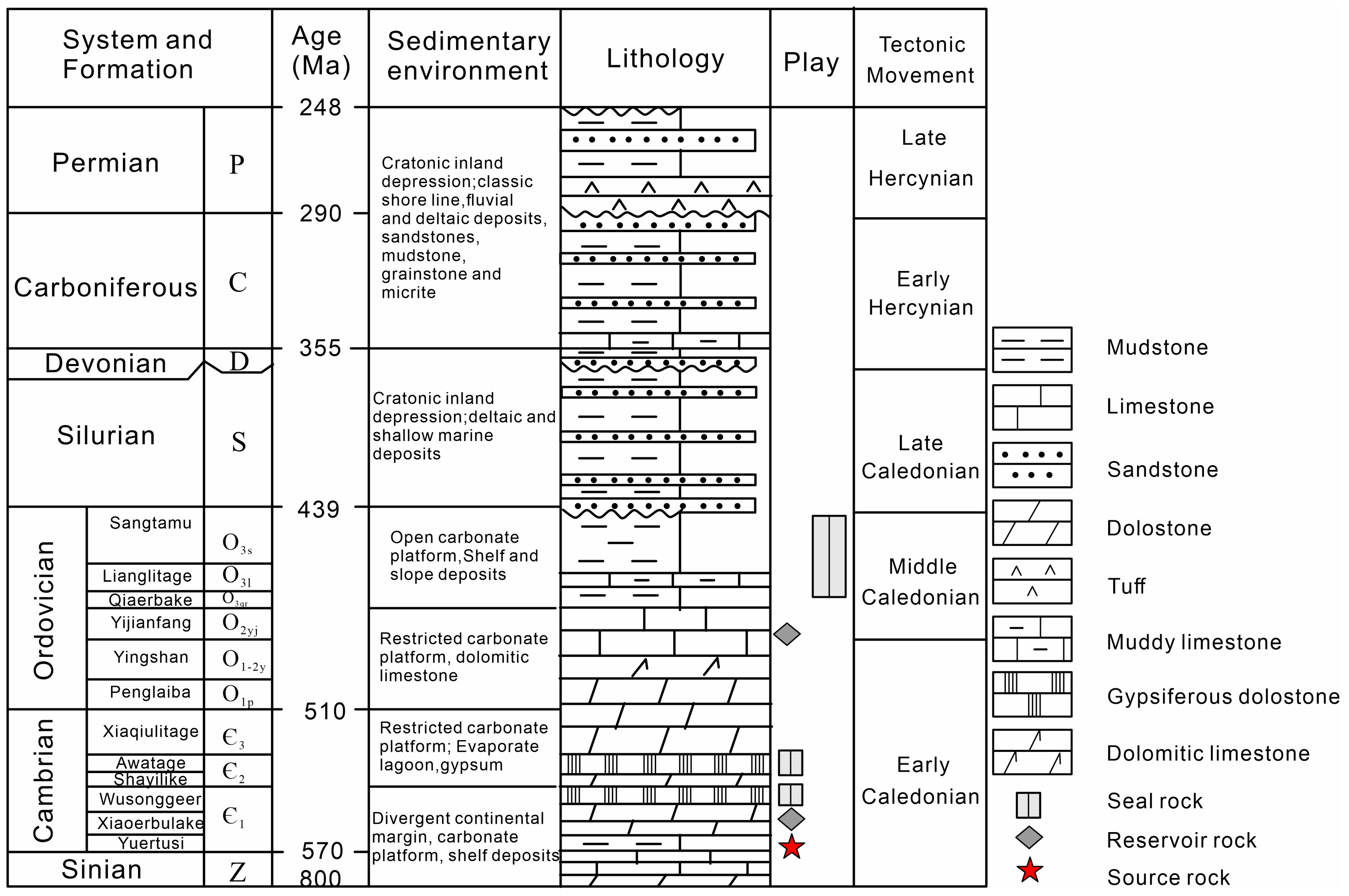
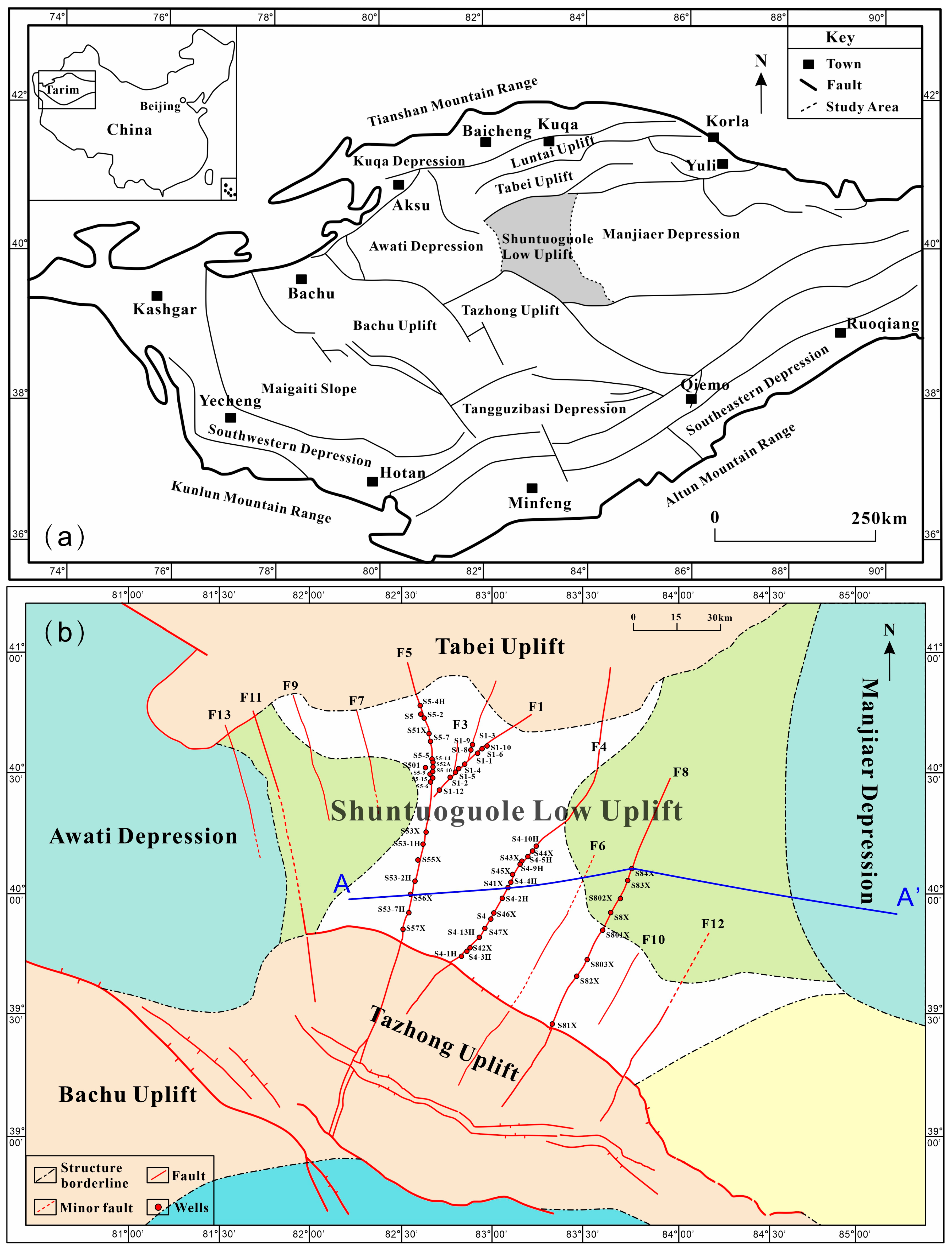
2. Geological Setting

The Tarim Basin, located in western China, holds great significance as a prolific oil- and gas-producing region. It is characterized by its formation as a marine petroliferous basin resulting from the convergence of cratons and foreland basins [18,19]. The Shuntuoguole low uplift, situated in the central region of the basin (Figure 1a), is flanked by the Tabei and Tazhong Uplifts to the north and south, respectively, while its eastern and western boundaries are demarcated by the Manjia’er and Awati Depression. The Shuntuoguole low uplift exhibits a relatively low elevation and gradual slope [20,21]. Multiple strike-slip faults are developed within the region (Figure 1b).
The Shuntuoguole region has experienced multiple tectonic adjustments throughout its history [22,23]. During the early Caledonian period, the basin was characterized by a stable extensional background, fostering regional tectonic subsidence and a continuous deposition of sedimentary layers. From the late Caledonian period to the early Hercynian period, there was strong overall compression, resulting in the development of strike-slip faults and the formation of the Tabei Uplift. During the late Hercynian period, the entire basin experienced uplift, leading to the uplift and subsequent erosion of the strata in the Tabei Uplift. During this period, a series of en echelon faults were formed in the study area. Finally, during the Himalayan period, the basin reached a relatively stable state, characterized by the presence of stable sedimentary strata and well-developed faults that underwent final adjustments to reach their current configuration [4,21]. A strike-slip fault formed by multi-stage activities have provided superior geological conditions for oil and gas migration and accumulation.
Stratigraphically, the Lower Paleozoic strata in the Shuntuoguole area are completely developed [6], with the mudstone of the Lower Cambrian Yuertus Formation identified as the principal source rock [24]. As depicted in Figure 2, the Cambrian system is structured from the bottom to the top, comprising the Lower Cambrian Yuertusi Formation (∈1y), the Xiaoerbulake Formation (∈1x), the Wusonggeer Formation (∈1w), the Middle Cambrian Shayilike Formation (∈2s), the Awatage Formation (∈2a), and the Upper Cambrian Lower Qiulitage Formation (∈3x). Meanwhile, the Ordovician system is also arranged from bottom to top, including the Lower Ordovician Penglaiba Formation (O1p), the Middle Lower Ordovician Yingshan Formation (O1-2y), the Middle Ordovician Yijianfang Formation (O2yj), and the Upper Ordovician Qiaerbake Formation (O3q), Lianglitage Formation (O3l), and Sangtamu Formation (O3s). Notably, the carbonate rocks of the Yingshan Formation and Yijianfang Formation are the key targets for oil and gas exploration in this area, creating a favorable reservoir-cap combination with the thick mudstone of the Upper Ordovician Sangtamu Formation (Figure 2) [25,26].
The reservoir in the Shuntuoguole area exhibits poor physical properties, characterized by an average porosity of 2.3% and an average permeability of 4.7 mD [27]. The research area exhibits the presence of multiple strike-slip faults, featuring various orientations such as northeast, northwest, and north-south. These faults, influenced by the stable tectonic background in the basin, display a relatively small amount of slip, typically less than 2 km. Remarkably, these faults traverse vertically through all the strata, extending from the source rock to the reservoir and eventually intersecting the mudstone cap rock. This unique geological arrangement creates exceptional conditions for the migration of oil and gas, offering favorable circumstances for the formation of reservoirs [28]. The presence of these faults exerts a significant “reservoir control” effect, dictating the distribution of hydrocarbon reservoirs within the region [29,30].
Figure 2. Lithostratigraphic column of the Shuntuoguole low uplift area, middle part of Tarim Basin (after Wang et al. [31]).
Energies 17 04261 g002

3. Material and Methods

This study collected natural gas samples from 40 wells located in the central part of the Shuntuoguole low uplift, mainly from the reservoirs of the Ordovician Yijianfang Formation and Yingshan Formation (Figure 1b, Table 1).
The natural gas components were analyzed using a gas chromatograph (GC). The GC utilized is the GC5890N, which is equipped with a flame ionization detector (FID) and a thermal conductivity detector (TCD).
Using helium gas as the carrier gas, the chromatographic column is an Al2O3PLOT column (50 m × 0.53 mm × 0.25 μm) with a split ratio of 60:1 and a flow rate of 1 mL/min. The temperature rise program of the chromatographic column is as follows: maintain the temperature at 40 °C for 10 min, then raise the temperature at a rate of 10 °C per minute to 180 °C, and maintain it for 30 min.
The carbon isotope analysis of natural gas samples was carried out using Delta V Advantage isotope mass spectrometer, with a Pora PLOT Q quartz column as the chromatographic column. The separated gas components were converted into CO2 through a high-temperature conversion furnace and then entered the isotope mass spectrometer to determine the carbon isotope composition. The temperature rise program of the chromatographic column was as follows: initial temperature 38 °C, constant temperature for 5 min, rising from 8 °C/min to 180 °C, and constant temperature for 15 min. The carrier gas is helium, with a flow rate of 2 mL/min. The standard sample is the international standard PDB carbon isotope, with a testing error of 0.5% (VPDB).
Hydrogen isotopes are analyzed using the same instrument, with an HP5 MS column as the chromatographic column. The chromatographic heating program is as follows: maintain at 35 °C for 4 min, raise at a rate of 5 °C/min to 90 °C, maintain for 2 min, raise at a rate of 10 °C/min to 150 °C, and raise at a rate of 20 °C/min to 230 °C, maintain for 3 min. Split ratio of 1:20, column flow rate of 1.0 mL/min. The temperature of the cracking furnace is 1400 °C. The analysis accuracy reaches 3%, and the standard is VSMOW.
The Northwest Oilfield Branch of Sinopec, located in Urumqi, China, has provided valuable geochemical data and on-site data. This includes information on the gas-oil ratio, chemical composition of natural gas, carbon isotopes, and more.

4. Results

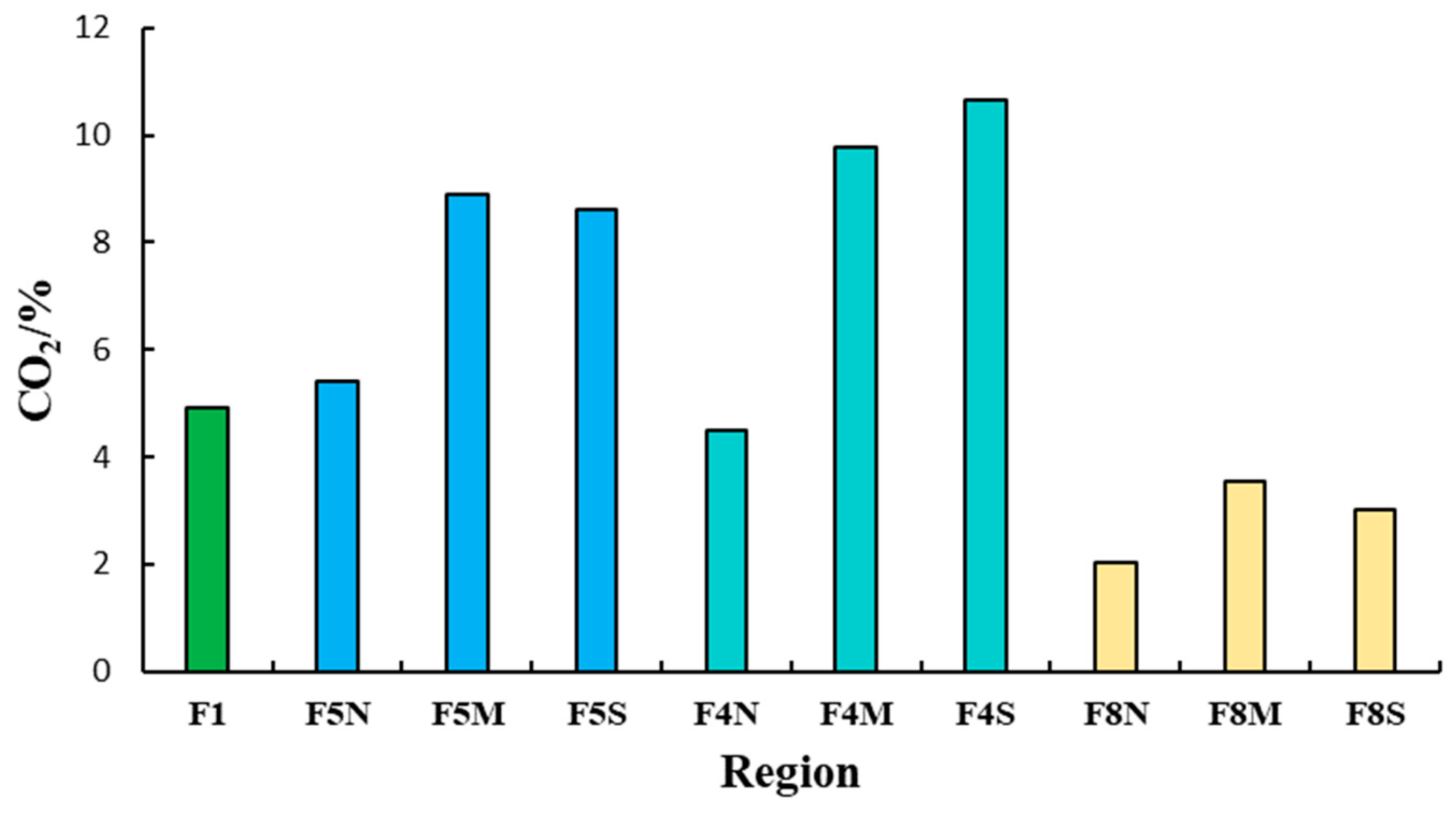
4.1. Characteristics of Natural Gas Components

Within the central part of the Shuntuoguole low uplift, variations in the relative density of natural gas are observed among different fault zones within the Ordovician ultra-deep layers. Notably, there is a gradual decrease in the relative density of natural gas from east to west. In specific fault zones, the average relative densities of natural gas are as follows: the northern section of the Shunbei No. 5 fault zone has an average relative density of 0.93, the southern middle section of the No. 5 fault zone has an average relative density of 0.71, the No. 1 fault zone has an average relative density of 0.7, the No. 4 fault zone has an average relative density of 0.71, and the No. 8 fault zone has an average relative density of 0.64.
In the central part of the Shuntuoguole low uplift, natural gas samples exhibit a predominant composition of hydrocarbon gases, comprising 71.29% to 97.79% of the total. Methane, the primary component, accounts for a wide range of 39.67% to 93.02%, with an average of 78.7% and the highest content observed. Ethane, on the other hand, ranges from 0.03% to 27.07%, averaging at 6.12%. Propane follows suit, representing 0.02% to 20.32% of the composition, with an average of 2.55%. The proportion of heavier hydrocarbons (C2+) is relatively low, Most of the values varying from 0.05% to 33.24% (Table 1). Regarding the drying coefficient of natural gas (C1/C1-C5), the values range from 0.41 to 0.99. Notably, the majority of samples (89.3%) exhibit a drying coefficient of less than 0.95. This indicates that the majority of the samples consist of “wet gas” with a lower degree of thermal evolution.
Significant variations in the drying coefficient are observed among different fault zones in Figure 3. The northern section of the No. 5 fault zone exhibits the lowest average drying coefficient, measuring merely 0.617, while the southern section of the No. 4 fault zone demonstrates the highest average drying coefficient at 0.948. In the case of the No. 8 fault zone, the average drying coefficient ranges from 0.904 to 0.944. Notably, several samples from the southern sections of the Shunbei No. 4, No. 5 and No. 8 fault zones, such as S4, S47X, S4-3H, S56X, S53-2H, S53-7H and S81X, demonstrate typical characteristics of dry gas. These samples possess drying coefficients exceeding 0.95, indicating a higher degree of thermal evolution and a predominantly dry gas.
In terms of the drying coefficient of natural gas, noticeable variations in maturity become apparent across the fault zones in the study area. Specifically, the southern sections of each fault zone exhibit higher gas maturity compared to the northern and middle sections. Furthermore, the maturity of natural gas in the Shunbei No. 8 fault zone shows similarity to that of the No. 4 fault zone but surpasses the maturity levels observed in the No. 5 and No. 1 fault zones. This suggests a gradual increase in gas maturity moving from north to south within each fault zone. Moreover, on a broader regional scale, the maturity of natural gas displays a trend of gradual increase from the northwest to the southeast.
The non-hydrocarbon gases present in the ultra-deep natural gas of the Ordovician formation in the central part of the Shuntuoguole low uplift primarily consist of N2 and CO2. The concentrations of these gases range from 0.14% to 16.97% for N2 and 1.55% to 22.11% for CO2, which align with the levels observed in adjacent blocks. However, it is worth noting that the CO2 content shows noticeable variations within the different sections of the Shunbei No. 5 and No. 8 fault zones (Figure 4). In the middle sections of the No. 5 fault zones, the CO2 concentration is relatively low, measuring around 3%. On the other hand, the southern sections of the No. 5 and No. 4 fault zones display a relatively higher CO2 content, nearing 10%.

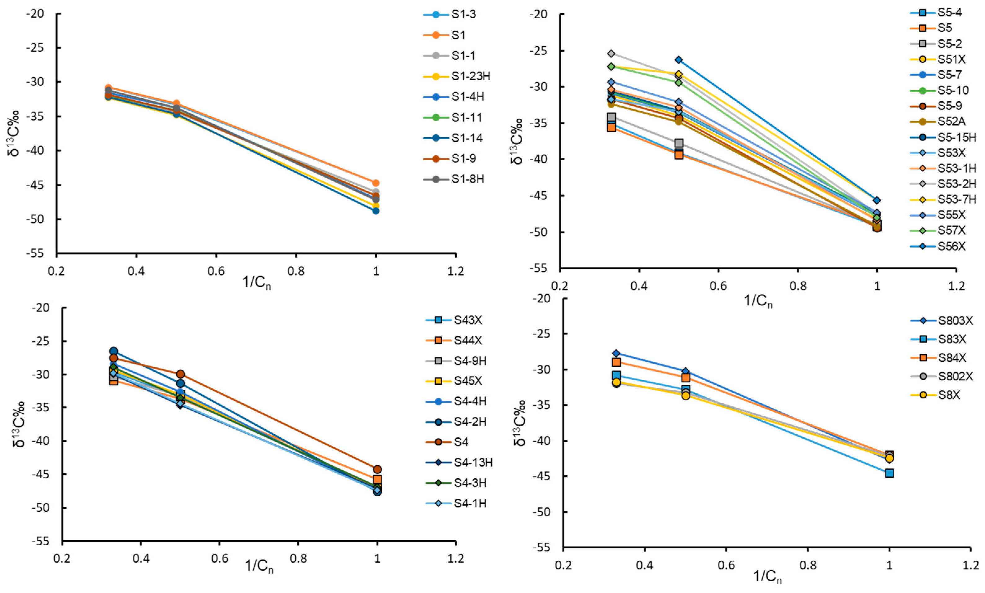
4.2. Carbon Isotope Characteristics of Natural Gas

The carbon isotopes of the ultra-deep natural gas extracted from the central zones of the Shuntuoguole low uplift exhibit relatively light values. The δ13C1 values range from −49.4‰ to −42‰, with an average of −46.8‰. The δ13C2 values range from −39.3‰ to −26.3‰, with an average of −33.2‰. Lastly, the δ13C3 values range from −35.6‰ to −25.4‰, with an average of −30.5‰ (Table 2). There are certain differences in methane carbon isotopes of Ordovician natural gas in different fault zones in the region. The methane carbon isotope values of natural gas in the 8th fault zone are higher than those in the No. 4 and No. 1 fault zones, while the methane carbon isotope values in the No. 5 fault zone are the lowest.
In addition, there are variations in methane carbon isotope values among different segments of the same fault zone. In the northern section of the Shunbei No. 5 fault zone, the average δ13C1 value is the lightest, measuring only −49‰. Moving to the middle section, the average δ13C1 value increases slightly to −48‰. In the southern section, the average δ13C1 value further increases to −47.2‰. Similarly, for the Shunbei No. 8 fault zone, the average δ13C1 value is the lightest in the northern section, with a measurement of −43.6‰. In the middle section, the average δ13C1 value slightly increases to −42.3‰.
Overall, there is a noticeable pattern in the carbon isotope values (δ13C1) within the Shunbei No. 5 and No. 8 fault zones, where the average values tend to become progressively heavier as one moves from the northern to the southern sections. Although there is some variability in the δ13C1 values among different sections of the fault zones, the differences are relatively small. This consistent trend is graphically represented in Figure 5.
The carbon isotopes of the different components of Ordovician ultra-deep natural gas found in various fault zones within the central part of the Shuntuoguole low uplift exhibit a distinctive positive carbon isotope pattern (δ13C1 < δ13C2 < δ13C3). There is no observed carbon isotope inversion, which indicates the presence of typical organic alkane gas characteristics (Figure 6) [35,36]. However, it is important to highlight that there are significant differences in the carbon isotope composition between the Shunbei No. 8 fault zone and the north central south section of the No. 5 fault zone. In both fault zones, the carbon isotopes follow a pattern where the south section exhibits higher values than the middle section, and the middle section exhibits higher values than the north section. On the other hand, the No. 4 fault zone displays a different pattern, with the middle section showing higher values than the south section, and the south section showing higher values than the north section. This suggests that even with the same oil and gas source, each fault zone may possess distinct oil and gas migration characteristics.

4.3. Hydrogen Isotope Characteristics of Natural Gas

The methane and hydrogen isotopes in the Ordovician ultra-deep layers of different fault zones in the central part of the Shuntuoguole low uplift exhibit distinct patterns. The δD1 values range from −207‰ to −146‰, with an average value of −168‰. The δD2 values range from −195‰ to −99‰, with an average value of −123‰. The δD3 values range from −157‰ to −81‰, with an average value of −110‰. The isotopic composition of Ordovician natural gas in different fault zones within the region reveals a consistent positive sequence, with δD1 displaying lower values than δD2, and δD2 exhibiting lower values than δD3. Notably, no hydrogen isotope inversion was observed (Figure 7). Furthermore, significant variations in hydrogen isotopes were identified among the fault zones in the region.
The methane hydrogen isotope values of natural gas in the No. 4 fault zone exhibit higher values compared to those in the No. 1 and No. 5 fault zones. Specifically, in the Shunbei No. 4 fault zone, the δD1 values reach the highest level at −156‰, while the average δD1 in the No. 1 fault zone is −166‰, and the average δ13D1 in the No. 5 fault zone is −179‰. These significant differences in methane and hydrogen isotopes are observed among the northern, central, and southern sections of the Shunbei No. 5 fault zone. The southern section exhibits higher values compared to the middle section, and the middle section, in turn, shows higher values compared to the northern section. Conversely, in the No. 4 fault zone, the middle section is characterized by higher isotopic values compared to the southern section, and the southern section has higher values compared to the northern section.

5. Discussion

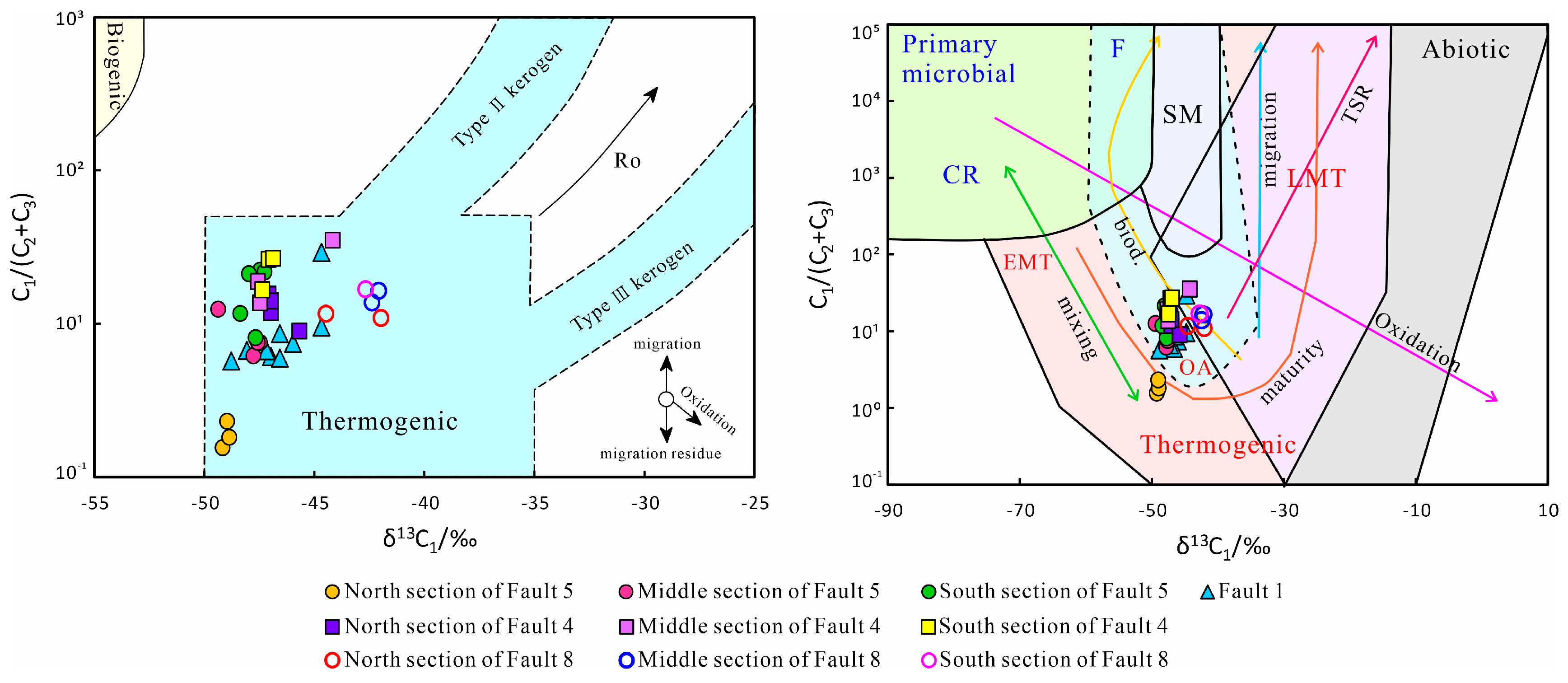
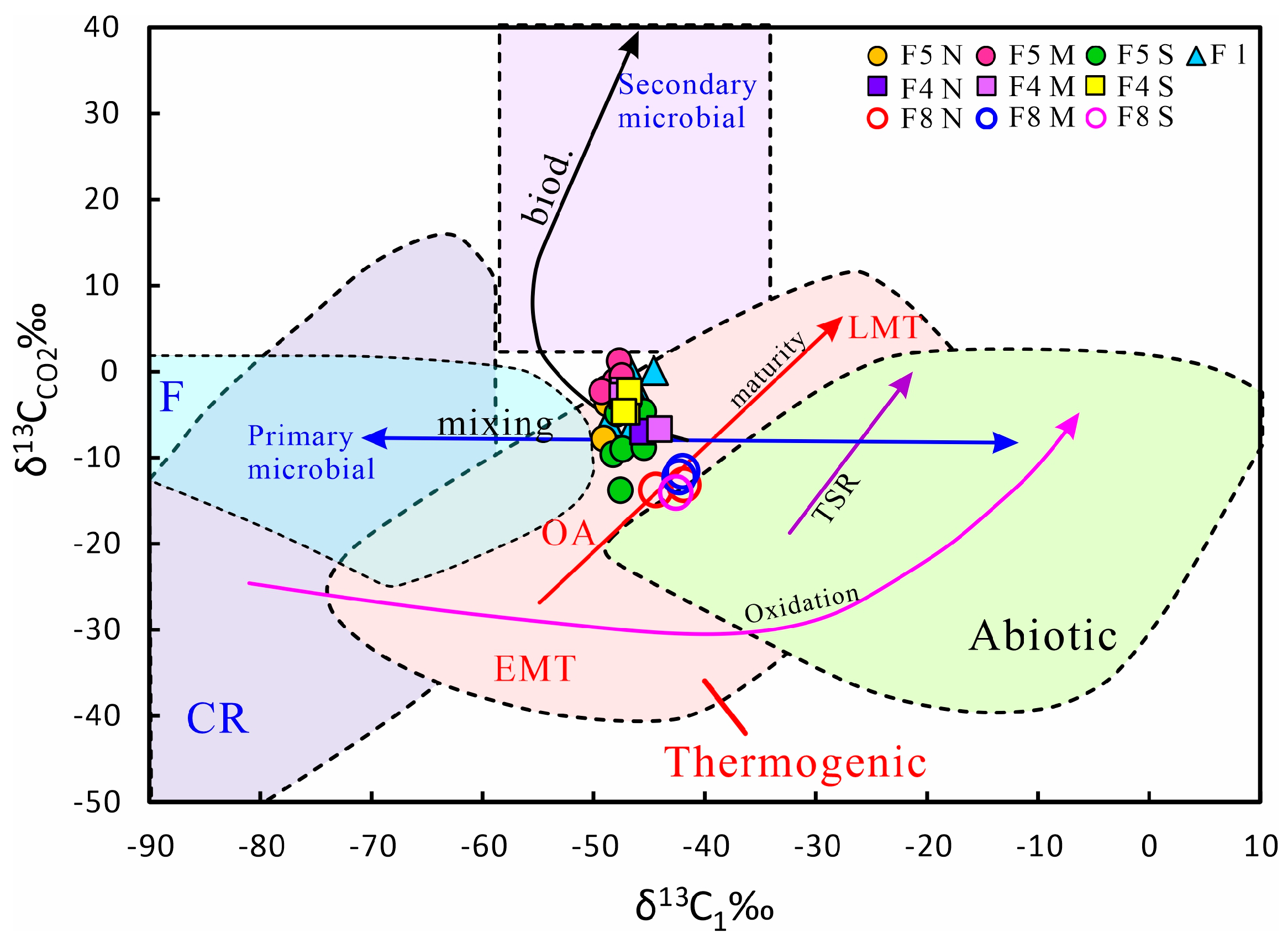
5.1. Natural Gas Genesis

In the platform basin area of the Tarim Basin, the predominant development of Cambrian marine source rocks is observed. The source rocks primarily consist of limestone, mudstone, and shale, forming layers with a thickness ranging from 10 to 15 m [7,37]. These rocks contain organic matter that serves as the parent material for hydrocarbon generation. The total organic carbon content (TOC) within these source rocks generally falls within the range of 1.0% to 16%. The type of hydrocarbon source rock parent material is sapropelic organic matter [38].
The main source of crude oil is primarily derived from lower aquatic organisms in marine sedimentary environments. The source rocks have achieved a relatively high level of maturity and are currently in the thermal evolution stage, ranging from high maturity to over maturity (Ro = 1.65%~3.61%) [39,40]. This stage is crucial for the conversion of crude oil to natural gas through cracking processes. The carbon and hydrogen isotope composition of ultra-deep natural gas from the Ordovician period in the central fault zone of the Shuntuoguole low uplift exhibits a progressively heavier positive isotope sequence as the molecular carbon number increases. Notably, the δ13C1 value of the natural gas is below −30%, indicating its characteristic as a typical organic hydrocarbon gas [35,41]
The analysis data of Ordovician ultra-deep natural gas from different fault zones in the study area were submitted for evaluation using the Bernard [42] and Milkov [43] diagrams. This analysis was based on the relationship between the δ13C1 hydrocarbon composition and the δ13C113CCO2 ratio (Figure 8 and Figure 9). Based on the analysis, it can be concluded that the natural gas from the Ordovician period in the central fault zone of the Shuntuoguole low uplift is classified as organic thermogenic gas. This determination is supported by the findings in Figure 8 and Figure 9, as well as the methane carbon and hydrogen isotope chart [44] displayed in Figure 10, which further confirms the organic thermogenic nature of the natural gas in the central part of the Shuntuoguole low uplift.
Ethane carbon isotopes are widely employed for classifying the genetic types of natural gas. In their research, Dai Jinxing et al. [45] found that the δ13C2 value of oil-type gas typically falls below −28.5‰, while the δ13C3 value is usually lighter than −27.0‰. In contrast, the δ13C2 value of natural gas ranges from −28.0‰ to −28.5‰, indicating a zone of coexistence between two gas types, with coal-derived gas predominantly present in the mixture. Traditionally, the boundary value of −29% or −28% is commonly employed to distinguish between oil-type gas and coal-type gas based on ethane carbon isotope values. According to the analysis results, the δ13C2 and δ13C3 values of the deep natural gas from the Ordovician period in the study area are relatively low, and both values are lighter than the respective limit values for coal gas and oil-type gas. The natural gas from the Ordovician period in the Shunbei area exhibits typical characteristics of oil-type gas, which suggests that the source rock type is sapropelic source rock.
In the carbon isotope chart depicting methane, ethane, and propane in natural gas (Figure 11), the natural gas derived from the Ordovician reservoirs in the central fault zones of the Shuntuoguole low uplift primarily corresponds to areas associated with oil-type gas [45].

5.2. Natural Gas Sources

In the δ13C1–δ13C2 relationship diagram (Figure 12) of natural gas, it is evident that the deep natural gas originating from the Ordovician reservoirs in various fault zones within the central region of the Shuntuoguole low uplift displays typical features of normal crude oil-associated gas [46]. This indicates that the primary gas source material is predominantly derived from sapropelic organic matter.
Within the Ordovician strata, natural gas of varying maturity levels can be observed, particularly in the Shunbei No. 1, No. 5, and No. 4 fault zones. It is noteworthy that the δ13C1 value of these natural gases is significantly lighter, indicating the normal crude oil-associated gas characteristics. This suggests that the natural gas primarily originates from mature to high mature marine sapropelic source rocks. When comparing the wells in the Shunbei No. 8 fault zone, a distinct characteristic emerges: the δ13C1 values of natural gas are significantly heavier. This provides compelling evidence of the high maturity level of the natural gas in these areas, indicating that it primarily originates from Cambrian sapropelic source rocks that have reached the stage of high to over maturity.
In the central part of the Shuntuoguole low uplift, the Ordovician ultra-deep layers exhibit variations in methane hydrogen isotopes across different fault zones. The δ D1 values range from −207‰ to −146‰, with an average value of −168‰. In general, a positive sequence characteristic is observed, (δ D1 < δ D2 < δ D3). Importantly, no hydrogen isotope inversion was observed, as depicted in Figure 7. The observed δ D1 values indicate that the parent material of the natural gas in the Ordovician ultra-deep layers likely originates from marine facies [47]. Furthermore, they suggest that the sedimentary environment water body formed by the source rock had a high salinity, which is consistent with the presence of Cambrian marine source rocks in the Tarim Basin. The relatively wide distribution range of the δ D1 values can be attributed to the mixing effect of natural gas with different maturity levels, indicating a complex composition.
In the central part of the Shuntuoguole low uplift, the Ordovician reservoirs have a high natural gas to oil ratio, ranging from 2000 to 5000 m3/m3. Most of the natural gas is the associated gas of crude oil, suggesting a common origin for both substances. It can be concluded that natural gas and crude oil in this region are derived from low Cambrian source rocks. This conclusion is further supported by PetroChina’s encounter of wet gas with a dryness coefficient of 0.88 during drilling in the Cambrian Wusonggeer Formation [48].
The carbon isotopes of the natural gas components in the Ordovician reservoirs of the central part of the Shuntuoguole low uplift provide evidence that the hydrocarbon source rock is of marine sapropelic type. To further identify the evolution stages of sapropelic organic matter, the identification diagrams established by Li Jian et al. were utilized [49]. These diagrams, based on the ratios of LN (C1/C2) and LN (C2/C3) for kerogen cracking gas and crude oil cracking gas, enable the differentiation of various stages of sapropelic organic matter. From Figure 13, it is evident that the LN (C1/C2) values range from 0.92 to 3.81, and the LN (C2/C3) values range from 0.5 to 1.78. The No. 1 and No. 5 fault zones predominantly fall within the kerogen cracking area, indicating a maturity level of approximately 1.0%. This suggests the occurrence of normal crude oil-associated gas that is formed during the mature stage of kerogen cracking. In contrast, the natural gas found in the No. 4 and No. 8 fault zones is situated between the kerogen cracking gas and crude oil cracking gas curves. This indicates the presence of mixed crude oil cracking gas within the natural gas, showcasing a higher maturity level exceeding 1.0%.

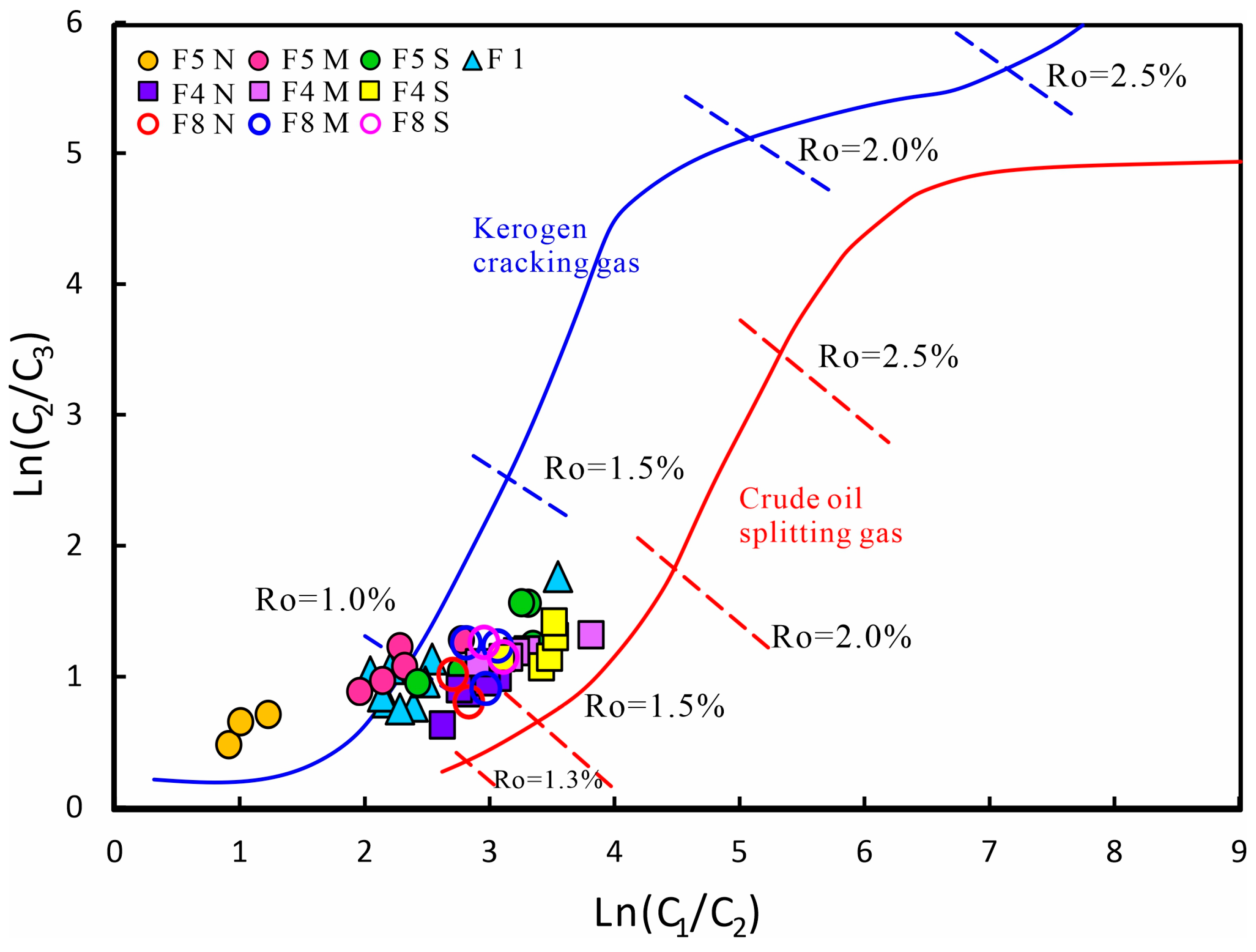
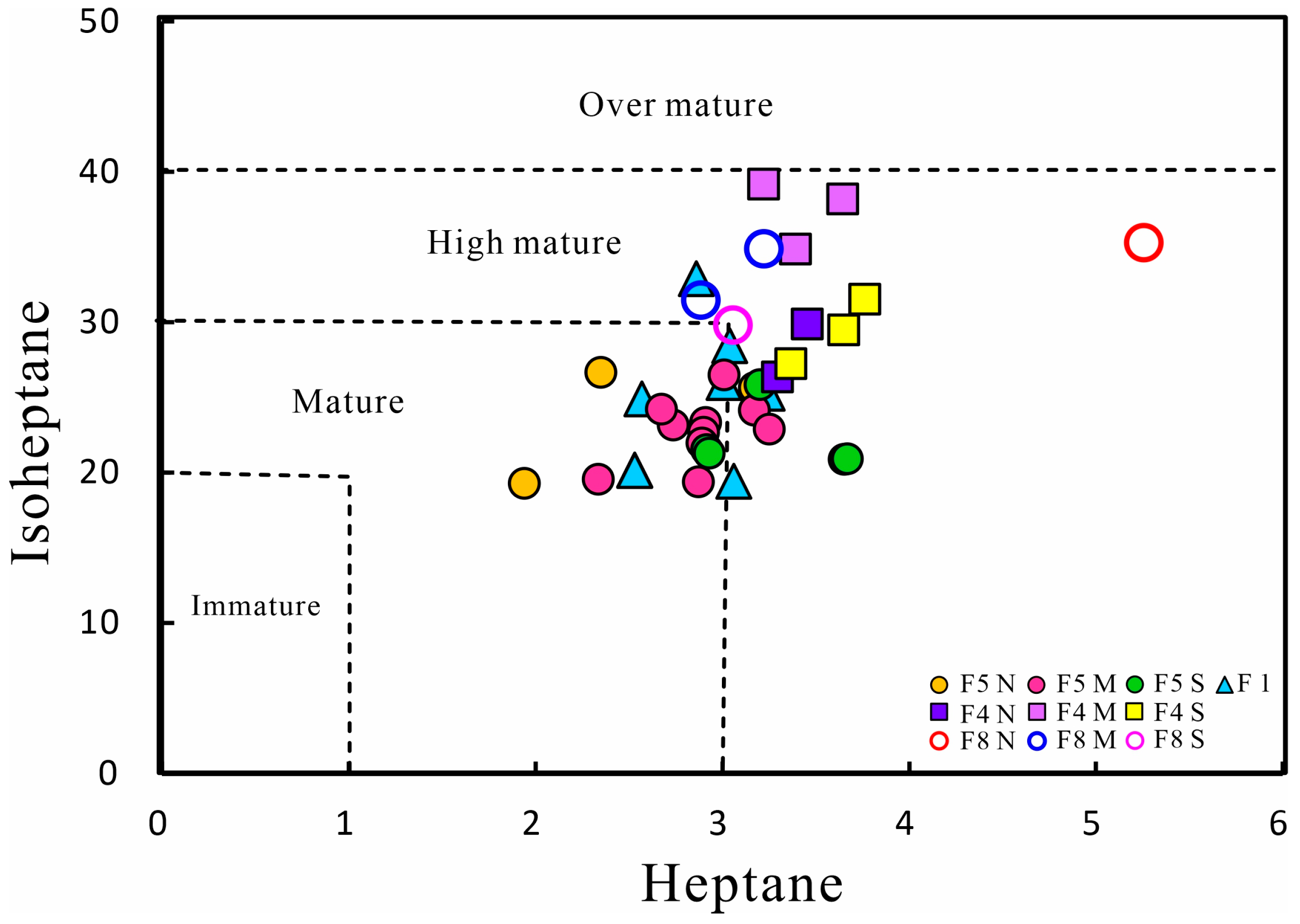
5.3. Maturity of Natural Gas

Through extensive thermal simulation experiments, both domestic and foreign scholars have successfully established empirical formulas linking natural gas characteristics, such as δ13C1, with the corresponding source rock maturity (RO) for different regions. The carbon isotope composition of the natural gas components found in the Ordovician formation within the central part of the Shuntuoguole low uplift suggests that it primarily consists of oil-type gas derived from marine sapropelic source rocks. The maturity level of the natural gas in this area was calculated using the relationship established by Shen Ping [32] and Huang Difan [33].
δ13C1 = 21.72lg RO1 − 43.4 (based on Ref. [32])
δ13C1 = 21.88lg RO2 − 45.6 (based on Ref. [33])
The calculated results indicate that the natural gas maturity within the Ordovician formation in the central part of the Shuntuoguole low uplift is moderate, with a range of 0.53% to 1.36% and an average of 0.73% for the Ro1 value. This indicates that the natural gas has reached a mature stage. It is a typical crude oil-associated gas generated from marine sapropelic kerogen during this mature stage. Additionally, the drying coefficient of the natural gas exhibits fluctuations along the fault zone, with a general trend of being high in the north and low in the south.
In addition to empirical formulas, light hydrocarbon parameters are commonly utilized for evaluating the maturity of oil and gas reservoirs. Through extensive experimental research, Thompson [50,51] proposed indicators for studying oil and gas maturity based on the highest temperature experienced during burial, specifically heptane number and isoheptane number. During the evolution of source rocks, the values of heptane and isoheptane exhibit a characteristic of increasing with maturity, and the rate of change is dependent on the type of kerogen. In the case of the Ordovician natural gas in the central part of the Shuntuoguole low uplift, the heptane value ranges from 19.28% to 39.2%, while the isoheptane value ranges from 1.94 to 5.25.
The isoheptane value exhibits a gradual increase from north to south within the Shunbei No. 5 fault zone, while it decreases in the same direction within the No. 8 fault zone. Additionally, the middle section of the No. 4 fault zone shows a relatively high isoheptane value compared to the north-south section. These variations in isoheptane values provide important indications regarding the maturity levels of the natural gas within the Ordovician formation in the central part of the Shuntuoguole low uplift. Based on the heptane and isoheptane values (Figure 14), it can be inferred that the natural gas in this region is in a mature to high mature stage.

5.4. Characteristics of Natural Gas Accumulation

The Shuntuoguole low uplift exhibits contrasting reservoir characteristics between its western and eastern parts. The western region is primarily an oil reservoir, while the eastern region is predominantly a gas reservoir. Significantly, there are notable differences in the natural gas dryness coefficient and gas oil ratio between the southeast and northwest regions [16]. Previous studies have suggested, based on oil source comparison, that the oil and gas reserves in the Shuntuoguole area originate from the source rocks of the Cambrian Yuertusi Formation in both the situ and Manjia’er Sags [15,52]. The variations in terrain and geothermal gradients between the eastern and western regions have resulted in differences in the thickness and maturity of source rocks [53,54].
The source rock in the western region of the area is characterized by a relatively small thickness and low maturity, whereas the source rock in the eastern region exhibits a significantly larger thickness and higher maturity. Over an extended period, the Tarim Basin has experienced a relatively low geothermal gradient, averaging between 1.9 and 2.1 °C/hm, with the current temperature estimated to be around 180 °C. Notably, the geothermal gradient in the Shunbei No. 1 and No. 5 fault zones ranges between 1.7 and 1.9 °C/hm, while the southeastern direction of the Shunnan area exhibits a higher geothermal gradient of 2.4 to 2.7 °C/hm.
As a result of the variations in source rock thickness and maturity, different types of natural gas can be observed within the region. In the Shunbei No. 1 and No. 5 fault zones, the natural gas primarily consists of kerogen cracking gas. However, in the southeast regions, specifically the Shunbei No. 4 and No. 8 fault zones, the increased maturity has led to the mixing of some crude oil cracking gas [55,56,57]. Considering the migration fractionation effect, it is observed that during the migration of oil and gas, molecules with smaller mass and lighter weight have a higher tendency to migrate. Conversely, heavier molecules with larger mass face greater challenges in migrating over long distances [58].
In this study, the Shunbei No. 5 and No. 8 fault zones exhibit an increasing trend in the average δ13C1 value from north to south. On the other hand, the average difference in δ13C1 in the No. 4 fault zone is relatively small. Additionally, there is a noticeable lightening trend in the δ13C1 values from the central to the north and south direction.
The carbon isotope composition of hydrocarbon gases is governed by the dynamic fractionation effect during C-C bond cleavage. Typically, the bond energy of 12C-12C is lower than that of 13C-13C. In the early stages of kerogen gas generation, 12C is more easily released from the parent material, leading to lighter carbon isotopes in natural gas. As the temperature of gas generation increases, a larger amount of 13C, which has a higher bond energy, is released from the parent material, causing the carbon isotopes in the resulting natural gas to become heavier [59]. During the diffusion migration of natural gas, the heavier carbon isotope 13C is more easily adsorbed by rocks than the lighter carbon isotope 12C. Additionally, due to its lower molecular weight and higher diffusion capability, 12C tends to become enriched along the migration pathway. As a result, the fractionation of methane carbon isotopes during natural gas migration is pronounced [60].
These observations suggest the possibility of natural gas migration from the south to the north direction. Furthermore, the top surface of the Ordovician strata in the study area displays a slope shape, with higher elevations in the northeast and lower elevations in the southwest. This topographical feature creates favorable conditions for natural gas migration from the southwest to the northeast [61,62].
In summary, based on a comprehensive analysis of the natural gas drying coefficient and carbon isotopes in the study area, it is inferred that within the fault zone, the migration of natural gas in the Shunbei No. 5 and No. 8 fault zones predominantly occurs from south to north. In contrast, the No. 4 fault zone exhibits a migration pattern from the central area towards both the northern and southern sides. Regionally, the migration of natural gas is primarily influenced by high and steep strike-slip faults, which serve as migration pathways. It migrates vertically along these faults, eventually reaching the fractured reservoirs of the Ordovician strata where it accumulates. Additionally, there is evidence of lateral migration from the western depression to the eastern slope, indicating a certain degree of horizontal movement. This lateral migration further contributes to the formation and distribution of natural gas reservoirs in the region (Figure 15).

6. Conclusions

(1)
The Ordovician ultra-deep natural gas found in the central region of the Shuntuoguole low uplift consists primarily of hydrocarbon gases. Most exhibit a drying coefficient range of 0.41–0.99, classifying them as wet gasses with a relatively low content of non-hydrocarbon gases, primarily consisting of CO2 and N2. Analysis of the carbon and hydrogen isotopes of natural gas alkanes reveals generally lighter isotopic values. Notably, variations in isotopic compositions are observed among different faults and segments of the same fault, displaying a positive distribution. These findings strongly indicate that the natural gas is of organic origin, primarily derived from alkane gas sources.
(2)
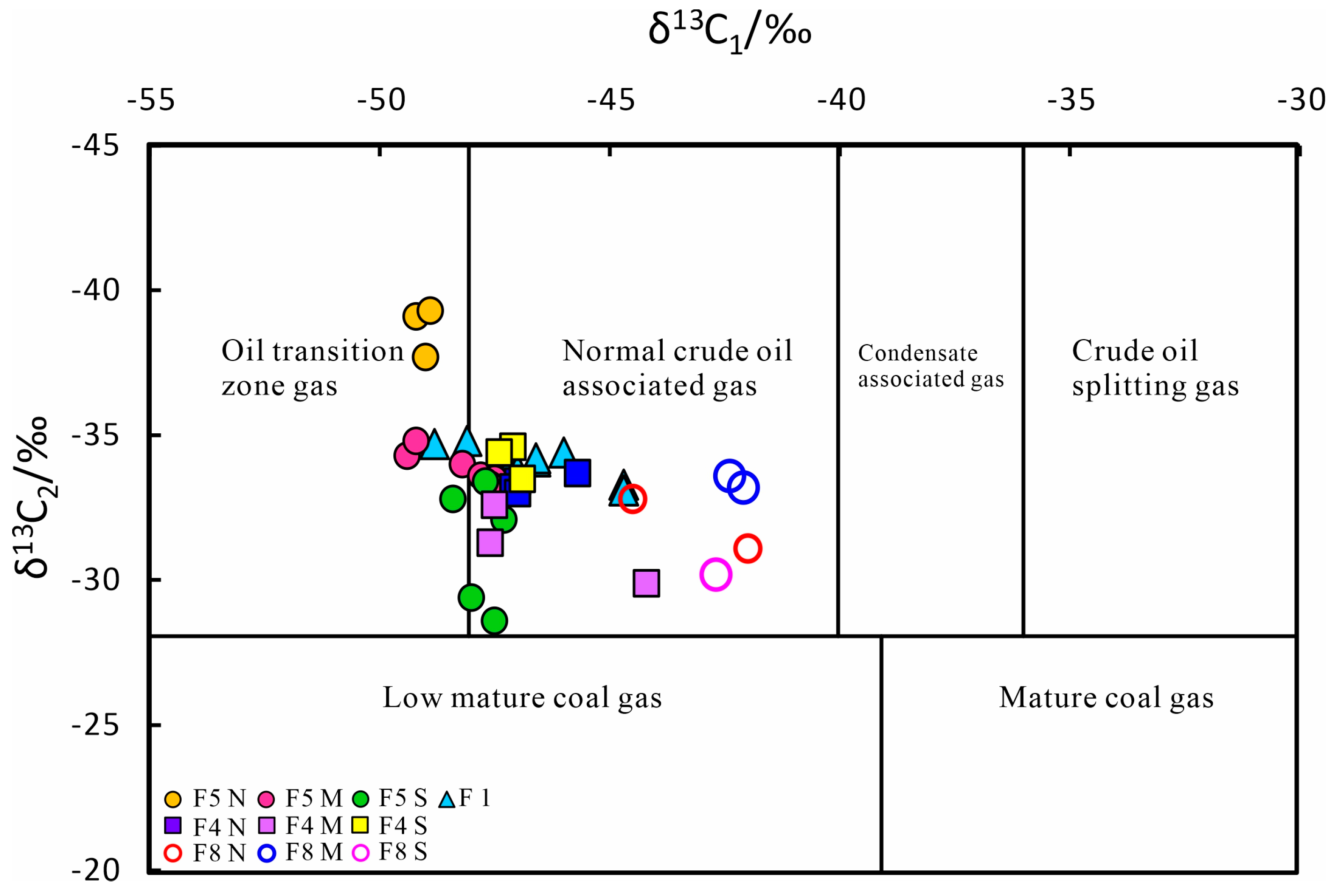
The ultra-deep natural gas derived from the Ordovician formations in the central part of the Shuntuoguole low uplift is classified as an oil-type gas. The source rock primarily consists of marine sapropelic organic matter. In the Shunbei No. 1, No. 5, and No. 4 fault zones, the δ13C1 value of the natural gas is significantly lighter, indicating its association with normal crude oil-associated gas. The natural gas predominantly comprises kerogen cracking gases, with variations in maturity observed among different fault zones. The No. 1 and No. 5 fault zones exhibit a maturity level of around 1.0% and are characterized by normal crude oil-associated gas in the mature stage. However, the No. 4 and No. 8 fault zones have a higher maturity level above 1.0%, resulting in a mixture of kerogen cracking gas and crude oil cracking gas.
(3)
The variations observed in the drying coefficient and carbon isotope of ultra-deep natural gas in different fault zones within the central region of the Shuntuoguole low uplift provide insights into the migration patterns of these gases. Specifically, the Shunbei No. 5 and No. 8 fault zones primarily exhibit a south-to-north migration trend, while the No. 4 fault zone displays migration from the central area to both the north and south sides. The migration of natural gas in this region is strongly influenced by the presence of steep strike-slip faults. It primarily undergoes vertical migration along these faults, eventually accumulating within the fractured reservoirs of the Ordovician formations. Additionally, there is evidence of lateral migration observed from the western depression to the eastern slope, contributing to the distribution of natural gas reservoirs across the area.

Author Contributions

Conceptualization, H.L. and J.Z.; investigation, H.L., Y.L. and C.L.; methodology, H.L. and J.Z.; data curation, H.L.; project administration, J.Z.; resources, J.Z.; supervision, J.Z. and Y.L.; validation, H.L., Y.L. and C.L.; writing—original draft, H.L.; writing—review and editing, J.Z. All authors have read and agreed to the published version of the manuscript.

Funding

This study was financially supported by the Joint Funds of the National Natural Science Foundation of China (U21B2063).

Data Availability Statement

The authors confirm that the data supporting the findings of this study are available upon request.

Acknowledgments

We thank the SINOPEC Northwest Oil field Company for providing the oil and gas samples and necessary data.

Conflicts of Interest

The authors declare no conflicts of interest.

References

  1. Pang, X.; Wang, W.; Wang, Y.; Wu, L. Comparison of otherness on hydrocarbon accumulation conditions and characteristics between deep and middle-shallow in petroliferous basins. Acta Pet. Sin. 2015, 36, 1167–1187. [Google Scholar]
  2. Pang, X.-Q.; Jia, C.-Z.; Wang, W.-Y. Petroleum geology features and research developments of hydrocarbon accumulation in deep petroliferous basins. Pet. Sci. 2015, 12, 1–53. [Google Scholar] [CrossRef]
  3. Yang, H.; Han, J. Reservoir forming characteristics and main controlling factors of Lunnan compound oil and gas accumulation area in Tarim Basin. Sci. Sin. 2007, 2, 53–62. [Google Scholar]
  4. Qi, L. Characteristics and inspiration of ultra-deep fault-karst reservoir in the Shunbei area of the Tarim Basin. China Pet. Explor. 2020, 25, 102–111. [Google Scholar]
  5. Zhu, X.; Cao, Z.; Long, H.; Zeng, J.; Huang, C.; Chen, X. Experimental simulation and characteristics of hydrocarbon accumulation in strike-slip fault zone in Shunbel area, Tarim Basin. Earth Sci. 2023, 30, 289–304. [Google Scholar] [CrossRef]
  6. Han, J.; Kuang, A.; Neng, Y.; Huang, C.; Li, Q.; Chen, P.; Shen, Z. Vertical Layered Structure of Shunbei No.5 Strike-Slip Fault Zone and Its Significance onHydrocarbon Accumulation. Xinjiang Pet. Geol. 2021, 42, 152–160. [Google Scholar]
  7. Gu, Y.; Huang, J.; Jia, C.; Shao, Z.; Sun, Y.; Lu, Q. Research progress on marine oil and gas accumulation in Tarim Basin. Pet. Geol. Exp. 2020, 42, 1–12. [Google Scholar]
  8. Cao, Z.; Lu, Q.; Gu, Y.; Wu, X.; You, D.; Zhu, X. Characteristics of Ordovician reservoirs in Shunbei 1 and 5 fault zones, Tarim Basin. Oil Gas Geol. 2020, 41, 975–984. [Google Scholar]
  9. Lotfy, N.M.; Farouk, S.; Hakimi, M.H.; Ahmad, F.; El Shennawy, T.; El Nady, M.M.; Salama, A.; Shehata, A.M. Biomarker and isotopic characteristics of Miocene condensates and natural gases, West Delta deep marine concession, Eastern Mediterranean, Egypt. Sci. Rep. 2024, 14, 235. [Google Scholar] [CrossRef]
  10. Lotfy, N.M.; Qteishat, A.; Farouk, S.; Ahmad, F.; Al-Kahtany, K.; Hsu, C.S. Geochemical characteristics and genetic types of Ordovician tight gas in the Risha Gas Field, Eastern Jordan based on carbon and hydrogen isotope compositions. Mar. Pet. Geol. 2022, 143, 105810. [Google Scholar] [CrossRef]
  11. Fuex, A.N. The use of stable carbon isotopes in hydrocarbon exploration. J. Geochem. Explor. 1977, 7, 155–188. [Google Scholar] [CrossRef]
  12. Luo, M.; Xia, Y.; Shao, X.; Wu, X. Geochemical characteristics and origin of oil from different strata in Shunbei oil and gas field, Tarim Basin. Pet. Geol. Exp. 2019, 41, 849–854. [Google Scholar]
  13. Gu, R.; Yun, L.; Zhu, X.; Zhu, M. Oil and gas sources in Shunbei Oilfield, Tarim Basin. Pet. Geol. Exp. 2020, 42, 248–254+262. [Google Scholar]
  14. Wang, T.; Song, D.; Li, M.; Yang, C.; Ni, Z.; Li, H.; Cao, Z.; Zhang, B.; Feng, Z. Natural gas source and deep gas exploration potential of the Ordovician Yingshan Formation in the Shunnan-Gucheng region, Tarim Basin. Oil Gas Geol. 2014, 35, 753–762. [Google Scholar]
  15. Yun, l. Hydrocarbon Accumulation of Ultra-Deep Ordovician Fault-Karst Reservoirs in Shunbei Area. Xinjiang Pet. Geol. 2021, 42, 136–142. [Google Scholar]
  16. Ma, A.; Jin, Z.; Li, H.; Gu, Y.; Qiu, N.; Zhu, X.; Wu, X.; Yang, X.; Wang, S. Secondary Alteration and Preservation of Ultra-Deep Ordovician Oil Reservoirs of North Shuntuoguole Area of Tarim Basin, NW China. Earth Sci. 2020, 45, 1737–1753. [Google Scholar]
  17. Ma, A.; Qi, L. Geochemical characteristics and phase behavior of the Ordovician ultra-deep reservoir fluid, No.4 fault, northern Shuntuoguole, Tarim Basin. Earth Sci. Front. 2023, 30, 247–262. [Google Scholar] [CrossRef]
  18. Wu, C.; Zhao, X.; Wu, G.; Li, F.; Zhang, H.; Hu, Z.; Li, S. Characteristics and distribution of fault-controlled carbonate reservoirs in Yijianfang Formation of Yueman area, northern Tarim Basin. Geol. China 2021, 3, 762–779. [Google Scholar]
  19. Wei, G.; Zhu, Y.; Zheng, J.; Yu, G.; Ni, X.; Yan, L.; Tian, L.; Huang, L. Tectonic-lithofacies paleogeography, large-scale source-reservoir distribution and exploration zones of Cambrian subsalt formation Tarim Basin, NW China. Pet. Explor. Dev. 2021, 48, 1114–1126. [Google Scholar] [CrossRef]
  20. Han, X.; Tang, L.; Cao, Z.; Wei, H.; Fu, C. Characteristics and Formation Mechanism of Composite flower Structures in Northern Slope of Tazhong Uplift, Tarim Basin. Earth Sci. 2018, 43, 525–537. [Google Scholar]
  21. Tang, L.; Qi, L.; Qiu, H.; Yun, L.; Li, M.; Xie, D.; Yang, Y.; Wan, G. Poly-phase differential fault movement and hydrocarbon accumulation of the Tarim Basin, NW China. Acta Petrol. Sin. 2012, 28, 2569–2583. [Google Scholar]
  22. He, D.; Zhou, X.; Yang, H.; Guan, S.; Zhang, C. Formation mechanism and tectonic types of intracratonic paleo-uplifts in the Tarim basin. Earth Sci. Front. 2008, 2, 207–221. [Google Scholar]
  23. Qiu, H.; Deng, S.; Cao, Z.; Yin, T.; Zhang, Z. The Evolution of the Complex Anticlinal Belt with Crosscutting Strike-Slip Faults in the Central Tarim Basin, NW China. Tectonics 2019, 38, 2087–2113. [Google Scholar] [CrossRef]
  24. Yan, L.; Zhu, G.; Chen, Y.; Han, C.; Yang, M.; Du, D.; Zhu, W. Distribution of Lower Cambrian source rocks in the Tarim Basin. Nat. Gas Geosci. 2019, 30, 1569–1578. [Google Scholar]
  25. Qi, L. Oil and gas breakthrough in ultra-deep Ordovician carbonate formations in Shuntuoguole uplift, Tarim Basin. China Pet. Explor. 2016, 21, 38–51. [Google Scholar]
  26. Lv, H.; Han, J.; Zhang, J.; Liu, Y.; Li, Y. Development characteristics and formation mechanism of ultra-deep carbonate fault-dissolution body in Shunbei area, Tarim Basin. Pet. Geol. Exp. 2021, 43, 14–22. [Google Scholar]
  27. Jiao, F. Significance and prospect of ultra-deep carbonate fault-karst reservoirs in Shunbei area, Tarim Basin. Oil Gas Geol. 2018, 39, 207–216. [Google Scholar]
  28. Jiao, F. Significance of oil and gas exploration in NE strike-slip fault belts in Shuntuoguole area of Tarim Basin. Oil Gas Geol. 2017, 38, 831–839. [Google Scholar]
  29. Deng, S.; Li, H.; Zhang, Z.; Wu, X.; Zhang, J. Characteristics of differential activities in major strike-slip fault zones and their control on hydrocarbon enrichment in Shunbei area and its surroundings, Tarim Basin. Oil Gas Geol. 2018, 39, 878–888. [Google Scholar]
  30. Deng, S.; Liu, Y.; Liu, J.; Han, J.; Wang, B.; Zhao, R. Structural styles and Evolution Models of Intracratonic Strike-slip Faults and the Implications for Reservoir Exploration and Appraisal: A Case Study of the Shunbei Area, Tarim Basin. Geotecton. Et Metallog. 2021, 45, 1111–1126. [Google Scholar] [CrossRef]
  31. Wang, Q.; Hao, F.; Cao, Z.; Tian, J.; Cong, F. Geochemistry and origin of the ultra-deep Ordovician oils in the Shunbei field, Tarim Basin, China: Implications on alteration and mixing. Mar. Pet. Geol. 2021, 123, 104725. [Google Scholar] [CrossRef]
  32. Shen, P.; Xu, Y.; Wang, X. The Geochemical Characteristics of Gas-Source Rocks and Natural Gases and Gas Generating Mechanism; Science TechniquePress of Gansu: Lanzhou, China, 1991. [Google Scholar]
  33. Huang, D.; Zhao, M.; Liu, B.; Wang, T.; Chen, S.; Xu, Y. Types of natural gas genesis in the eastern Tarim Basin and their maturity determination. Sci. Sin. 1996, 4, 365–372. [Google Scholar]
  34. Cao, Z.; Yun, l.; Ping, H.; Li, H.; Geng, F.; Han, J.; Huang, C.; Mao, Q.; Ding, Y. Geochemistry and origin of Ordovician natural gas in Shunbei area of Tarim Basin. Bull. Geol. Sci. Technol. 2024, 1–16. [Google Scholar] [CrossRef]
  35. Dai, J.; Xia, X.; Qin, S.; Zhao, J. Causation of partly reversed orders of δ13C in biogenic alkane gas in China. Oil Gas Geol. 2003, 1, 1–6+11. [Google Scholar]
  36. Dai, J.; Zou, C.; Zhang, S.; Li, J.; Ni, Y.; Hu, G.; Luo, X.; Tao, S.; Zhu, G.; Mi, J.; et al. Identification of inorganic and organic hydrocarbon gases. Sci. Sin. 2008, 11, 1329–1341. [Google Scholar]
  37. Zhu, G.; Chen, F.; Chen, Z.; Zhang, Y.; Xing, X.; Tao, X.; Ma, D. Discovery and basie characteristies of the high quality source rocksof the Cambrian Yuertusi Formation in Tarim Basin. Nat. Gas Geosci. 2016, 27, 8–21. [Google Scholar]
  38. Dai, J.; Pei, X.; Qi, H. China Natural Gas Geology; Petroleum Industry Press: Beijing, China, 1992; Volume 1. [Google Scholar]
  39. Li, F.; Zhu, G.; Lv, X.; Zhang, Z.; Wu, Z.; Xue, N.; He, T.; Wang, R. The disputes on the source of Paleozoic marine oil and gas and the determination of the Cambrian system as the main source rock in Tarim Basin. Acta Pet. Sin. 2021, 42, 1417–1436. [Google Scholar]
  40. Zhang, S.; Zhang, B.; Yang, H.; Zhu, G.; Su, J.; Wang, X. Adjustment and alteration of hydrocarbon reservoirs during the late Himalayan period, Tarim Basin, NW China. Pet. Explor. Dev. 2012, 39, 668–680. [Google Scholar] [CrossRef]
  41. Dai, J. Significance of the study on carbon isotopes of alkane gases. Nat. Gas Ind. 2011, 31, 1–6+123. [Google Scholar]
  42. Bernard, B.B.; Brooks, J.M.; Sackett, W.M. Natural gas seepage in the Gulf of Mexico. Earth Planet. Sci. Lett. 1976, 31, 48–54. [Google Scholar] [CrossRef]
  43. Milkov, A.V.; Etiope, G. Revised genetic diagrams for natural gases based on a global dataset of >20,000 samples. Org. Geochem. 2018, 125, 109–120. [Google Scholar] [CrossRef]
  44. Whiticar, M.J. Carbon and hydrogen isotope systematics of bacterial formation and oxidation of methane. Chem. Geol. 1999, 161, 291–314. [Google Scholar] [CrossRef]
  45. Dai, J.; Gong, D.; Ni, Y.; Yu, C.; Wu, W. Genetic Types of the Alkane Gases in Giant Gas Fields with Proven Reserves over 1000 × 108 m3 in China. Energy Explor. Exploit. 2014, 32, 1–18. [Google Scholar] [CrossRef]
  46. Rooney, M.A.; Claypool, G.E.; Moses Chung, H. Modeling thermogenic gas generation using carbon isotope ratios of natural gas hydrocarbons. Chem. Geol. 1995, 126, 219–232. [Google Scholar] [CrossRef]
  47. Miao, Z.; Chen, J.; Zhang, C.; Chen, H.; Wang, G. Regularity of distribution and accumulation stages of natural gases in the Lunnan lower uplift of the Tarim Basin. Acta Pet. Sin. 2011, 32, 404–410. [Google Scholar]
  48. Yang, H.; Chen, Y.; Tian, J.; Du, J.; Zhu, Y.; Li, H.; Pan, W.; Yang, P.; Li, Y.; An, H. Great discovery and its significance of ultra-deep oil and gas exploration in well Luntan-1 of the Tarim Basin. China Pet. Explor. 2020, 25, 62–72. [Google Scholar]
  49. Li, J.; Li, Z.; Wang, X.; Wang, D.; Xie, Z.; Li, J.; Wang, Y.; Han, Z.; Ma, C.; Wang, Z.; et al. New indexes and charts for genesis identification of multiple natural gases. Pet. Explor. Dev. 2017, 44, 503–512. [Google Scholar] [CrossRef]
  50. Thompson, K.F.M. Light hydrocarbons in subsurface sediments. Geochim. Et Cosmochim. Acta 1979, 43, 657–672. [Google Scholar] [CrossRef]
  51. Thompson, K.F.M. Classification and thermal history of petroleum based on light hydrocarbons. Geochim. Cosmochim. Acta 1983, 47, 303–316. [Google Scholar] [CrossRef]
  52. Gu, Y.; Wan, Y.; Huang, J.; Zhuang, X.; Wang, B.; Li, M. Oil and gas exploration prospect of ultra deep layer in Tarim Basin under the condition of large burial depth and high pressure. Pet. Geol. Exp. 2019, 41, 157–164. [Google Scholar]
  53. Zhu, G.; Li, T.; Zhang, Z.; Zhao, K.; Zhang, K.; Chen, W.; Yan, H.; Wang, P. Distribution and geodynamic setting of the Late Neoproterozoic–Early Cambrian hydrocarbon source rocks in the South China and Tarim Blocks. J. Asian Earth Sci. 2020, 201, 104504. [Google Scholar] [CrossRef]
  54. Xiong, R.; Zhou, J.; Ni, X.; Zhu, Y.; Chen, Y. Distribution prediction of Lower Cambrian Yuertusi Formation source rocks and its significance to oil and gas exploration in the Tarim Basin. Nat. Gas Ind. 2015, 35, 49–56. [Google Scholar]
  55. Ma, A.L. Kinetics of oil-cracking of different types of marine oils from Tahe Oilfield, Tarim Basin, NW China. Nat. Gas Geosci. 2015, 26, 1120–1128. [Google Scholar] [CrossRef]
  56. Zhu, G.; Zhang, S.; Su, J.; Huang, H.; Yang, H.; Gu, L.; Zhang, B.; Zhu, Y. The occurrence of ultra-deep heavy oils in the Tabei Uplift of the Tarim Basin, NW China. Org. Geochem. 2012, 52, 88–102. [Google Scholar] [CrossRef]
  57. Ma, A.; He, Z.; Yun, L.; Wu, X.; Li, H.; Qiu, N.; Chang, J.; Lin, H.; Cao, Z.; Zhu, X.; et al. The geochemical characteristics and origin of Ordovician ultra-deep natural gas in the North Shuntuoguole area, Tarim Basin, NW China. Nat. Gas Geosci. 2021, 32, 1047–1060. [Google Scholar] [CrossRef]
  58. Hou, D.; Feng, Z. Petroleum Geochemistry; Petroleum Industry Press: Beijing, China, 2011. [Google Scholar]
  59. Peng, W.; Liu, Q.; Hu, G.; Lv, Y.; Zhu, D.; Meng, Q.; Guo, F.; Wang, R. Mechanisms of carbon isotope fractionation in the process of natural gas generation: Geochemical evidence from thermal simulation experiment. Pet. Explor. Dev. 2020, 47, 972–983. [Google Scholar] [CrossRef]
  60. Qin, S.; Tang, X.; Song, Y.; Wang, H. Distribution and fractionation mechanism of stable carbon isotope of coalbed methane. Sci. China Ser. D Earth Sci. 2006, 49, 1252–1258. [Google Scholar] [CrossRef]
  61. Bian, J.; Hou, D.; Cheng, X.; Jia, Z. Origin of the Ultra-Deep Hydrocarbons from the Shunbei No. 1 Fracture Zone in the North of Shuntuoguole Low Uplift, Tarim Basin, North-Western China. Appl. Sci. 2023, 13, 5297. [Google Scholar] [CrossRef]
  62. Bian, J.; Hou, D.; Cui, Y.; Zhu, X. Geochemical characteristics and origin of the ultra-deep hydrocarbons from the Shunbei Oilfield in the Tarim Basin, China: Insight from molecular biomarkers and carbon isotope geochemistry. Mar. Pet. Geol. 2023, 158, 106542. [Google Scholar] [CrossRef]
Figure 1. (a) Tectonic units of the Tarim Basin and location of the Shuntuoguole low uplift area. (b) Distribution map of wells in the Shuntuoguole low uplift area for sample collection.
Energies 17 04261 g001
Figure 3. Distribution of natural gas drying coefficient in the middle of the Shuntuoguole low uplift.
Energies 17 04261 g003
Figure 4. Distribution map of the average CO2 content in Ordovician natural gas in the central region of the Shuntuoguole low uplift.
Energies 17 04261 g004
Figure 5. Carbon isotope distribution map of Ordovician ultra-deep natural gas in various fault zones in the central region of the Shuntuoguole low uplift.
Energies 17 04261 g005
Figure 6. Carbon isotope distribution of natural gas components in the Ordovician ultra-deep layers of various fault zones in the central part of the Shuntuoguole low uplift.
Energies 17 04261 g006
Figure 7. Hydrogen isotope distribution of natural gas components in the Ordovician ultra-deep layers of various fault zones in the central part of the Shuntuoguole low uplift.
Energies 17 04261 g007
Figure 8. Gas genetic classification in the central part of the Shuntuoguole low uplift using the C1/(C2+C3) and δ13C1value (after Refs. [43,44]).
Energies 17 04261 g008
Figure 9. Gas genetic classification in the central part of the Shuntuoguole low uplift using the δ13CCO2 and δ13C1value (after Ref. [43]).
Energies 17 04261 g009
Figure 10. Plot of carbon and hydrogen isotope ratios of methane in the Ordovician ultra-deep natural gases in the central part of the Shuntuoguole low uplift (after Ref. [44]).
Energies 17 04261 g010
Figure 11. Carbon isotope correlation maps of methane, ethane, and propane in the Ordovician ultra-deep natural gas of various fault zones in the central part of the Shuntuoguole low uplift (based on Ref. [45]).
Energies 17 04261 g011
Figure 12. Plot of methane and ethane carbon isotopes in the Ordovician ultra-deep natural gas of various fault zones in the central part of the Shuntuoguole low uplift (based on Ref. [46]).
Energies 17 04261 g012
Figure 13. Plot of Ln(C1/C2) versus Ln(C2/C3) of Ordovician natural gases in the central part of the Shuntuoguole low uplift.
Energies 17 04261 g013
Figure 14. Plot of heptane value versus isoheptane value of Ordovician gas in the central part of the Shuntuoguole low uplift.
Energies 17 04261 g014
Figure 15. The schematic cross-section showing the characteristics of the Paleozoic strata along the A-A′ line in the central part of the Shuntuoguole low uplift, Tarim Basin.
Energies 17 04261 g015
Table 1. Composition characteristics of Ordovician Natural Gas in the Central Part of Shuntuoguole.
Chemical Composition/%Dryness Index
RegionWellDepth/mFormationC1C2C3iC4nC4iC5nC5O2N₂CO2H₂(C1/C1~C5) (%)
Fault 1S1-37274–7358O2yj70.985.591.770.320.480.120.120.3010.412.087.770.894
S1 *7269–7320O2yj+O1−2y84.182.430.410.030.06---1.5511.010.320.966
S1-17268–7318O2yj82.897.573.430.690.910.190.140.001.492.700.000.865
S1-23H7495–8070O2yj+O1−2y67.767.452.540.380.900.180.33-2.5316.361.580.852
S1-4H7459–7562O2yj80.359.053.980.701.010.210.19-2.202.320.000.841
S1-117572–7732O2yj71.788.393.530.641.040.230.260.5210.233.170.060.836
S1-147589–7710O2yj73.669.473.310.520.780.160.172.327.821.680.080.837
S1-97372–7630O2yj+O1−2y81.806.802.560.530.830.240.250.534.082.220.010.879
S1-8H7415–7571O2yj77.427.863.640.821.430.410.440.604.592.520.020.841
The north section of F5S5-47393–7480O2yj43.7017.3410.561.352.860.490.630.5415.726.120.170.568
S57314–7650O2yj+O1−2y47.1317.028.711.272.150.370.430.6816.975.090.010.612
S5-2 *7460–7527O2yj62.0618.008.701.081.900.320.33-2.365.050.190.672
The middle section of F5S5-67555O2yj87.176.160.590.020.020.010.010.283.082.600.040.928
S5-77562–7635O2yj+O1−2y80.149.343.490.470.940.110.12-3.821.650.010.847
S5-107639–8038O2yj+O1−2y82.218.362.410.270.440.060.00-4.182.070.010.877
S5-15H7632–7877O2yj+O1−2y83.258.152.730.370.620.090.09-2.522.150.020.874
S5-5H8200O2yj74.1710.394.210.781.280.320.350.315.912.140.010.811
S5-97648–7839O2yj47.572.960.810.120.320.080.150.000.0047.800.190.915
S52A/O2yj39.6727.0720.323.154.940.600.450.000.003.800.000.412
The southern section of F5S53X7740–8342O2yj+O1−2y80.157.062.680.571.160.230.32-0.826.680.150.870
S53-1H/O2yj86.785.441.880.370.730.150.190.000.623.810.040.908
S53-2H/O2yj87.903.210.660.170.300.000.130.001.715.790.140.952
S53-7H/O2yj91.270.650.080.000.000.000.000.001.006.950.050.992
S55X/O2yj77.532.730.770.240.330.150.141.636.809.610.020.947
S56X/O2yj+O1−2y71.230.030.020.000.000.000.000.236.1722.110.100.999
S57X/O2yj+O1−2y88.203.400.700.280.310.110.070.121.325.360.450.948
The north section of F4S43X7558–7995O2yj+O1−2y82.414.882.000.670.940.390.400.202.475.460.000.899
S44X/O2yj75.655.482.870.981.590.640.661.096.614.160.000.861
S4-5H/O1−2y83.675.302.100.580.830.320.330.001.514.630.720.898
S4-9H7600–8110O2yj+O1−2y89.684.161.510.421.040.380.590.000.641.550.030.917
S45X7664–8845O2yj+O1−2y75.893.851.451.220.610.260.240.468.116.661.150.909
The middle section of F4S4-4H7555–8591O2yj+O1−2y80.864.401.430.390.760.250.390.000.2011.270.040.914
S41X/O2yj81.252.990.880.340.370.210.170.813.659.200.000.942
S4-2H7551–8587O2yj+O1−2y82.883.331.000.300.570.230.360.000.1411.180.010.935
S46X/O2yj+O1−2y82.243.491.090.380.410.240.210.403.108.200.070.934
S47777O2yj+O1−2y86.151.910.500.100.200.000.000.001.938.960.260.970
The southern section of F4S42X/O2yj+O1−2y79.792.620.880.320.440.230.230.474.279.101.490.944
S47X/O2yj+O1−2y83.492.580.810.310.390.260.270.763.847.040.000.948
S4-13H/O2yj+O1−2y86.292.540.680.280.400.230.210.000.009.350.020.952
S4-3H7386–8179O2yj+O1−2y84.772.520.600.100.190.000.000.000.1711.640.010.961
S4-1H/O2yj77.703.491.100.230.480.120.170.000.3716.160.170.933
The north of F8S83X7726–8543O2yj+O1−2y87.585.162.260.610.780.000.23-1.191.950.050.906
S84X8400–9195O2yj+O1−2y86.575.792.050.520.560.000.17-1.652.080.490.905
The middle of F8S802X7827–8396O2yj+O1−2y88.544.141.180.340.380.130.100.272.612.250.000.934
S801X7691O2yj+O1−2y84.785.091.420.450.500.000.190.201.715.630.030.917
S8X7737–8396O2yj+O1−2y85.564.391.740.610.900.350.350.452.662.770.060.911
The southern of F8S803X7659–8110O2yj+O1−2y88.403.961.230.420.480.140.200.231.292.690.030.932
S82X7617–8262O2yj+O1−2y89.204.641.290.430.520.220.220.140.972.190.020.924
S81X7466–8308O2yj+O1−2y93.021.470.380.160.170.090.08-0.414.150.070.975
Note: “C1, C2, …”: method for naming hydrocarbons. C1: methane. C2: ethane. Data on the natural gas compositions were collected from the SINOPEC Northwest Company. “-” and “/”: no data or not determined. “*”: data collected from reference [16].
Table 2. Carbon and hydrogen isotope composition of Ordovician natural gas in the central part of Shuntuoguole.
δ13CPDB (‰)δDVsmow/‰
RegionWellDepth/mC1C2C3iC4nC4CO2δD1δD2δD3Ro1/%Ro2/%
F1S1-3 *7274–7358−44.7−33.3−30.8−34.2−290.1−170−140−1160.871.10
S1 *7269–7320−44.7−33.1−30.8−31.8−29.8/−157−127/0.871.10
S1-17268–7318−46−34.4−32.1−32.4−31.4−2.8−161−111−1050.760.96
S1-23H7495–8070−48.1−34.8−32.3−32.9−32/−178//0.610.77
S1-4H7459–7562−47−33.8−31.6−35.2−29.40.5−180−148−1160.680.86
S1-11 *7572–7732−46.6−34.1−32−32.4−31.4−6.4−156−113−1040.710.90
S1-14 *7589–7710−48.8−34.7−32.2−33−31.5−5.9−162−110−1010.560.71
S1-97372–7630−46.6−34.2−31.9−31.9−31.2−2.1−166−111−1040.710.90
S1-8H7415–7571−47.2−33.8−31.2−31.9−30.7−1.4−169−111−1010.670.85
The north of F5S5-4 *7393–7480−49.2−39.1−35.1−33.9−33.1−7.8−205−195−1570.540.68
S5 *7314–7650−48.9−39.3−35.6−34.6−33.4−3.7−207−180−1410.560.71
S5-2 *7460–7527−49−37.7−34.1−33.9−32.2−2///0.550.70
The middle of F5S51X7553–7876−48.2−34−31.2−31.1−29.6−1.1−183−135−1070.600.76
S5-77562–7635−47.8−33.6−30.9−31.1−29.71.2−182−131−1100.630.79
S5-107639–8038−47.5−33.5−30.7−31.8−29.4−1.1−182−128−1020.650.82
S5-15H7632–7877−47.6−33.3−30.6−30.8−29.5−0.5−180−127−1020.640.81
S5-97648–7839−49.4−34.3−31.7−32.1−31.7−2.3−181//0.530.67
S52A/−49.2−34.8−32.4−33.4−31.8/−189−135−1210.540.68
The southern of F5S53X7740–8342−47.7−33.4−31.7−31.4−30.4−13.8−159//0.630.80
S53-1H/−48.4−32.8−30.4−31−29.9−9.6−168−123−1140.590.74
S53-2H/−47.5−28.6−25.4−27.8−26.3−9−156−105−940.650.82
S53-7H/−45.6−28.2−27.2−27.3−27.4−8.8−150−102/0.791.00
S55X/−47.3−32.1−29.3−31.2−29.2−4.1−162−120−1100.660.84
S56X/−45.6−26.3///−4.7−152//0.791.00
S57X/−48−29.4−27.2−28.6−27.9−4.9///0.610.78
The north of F4S43X7558–7995−47−33.4−29.6−30.4−28.7−2.5−159−114 0.680.86
S44X/−45.7−33.7−30.9−32−30.7−7−160−121−1100.780.99
S4-9H7600–8110−47.1−33.2−30.3−31.5−30.6−2.3−163−110/0.680.85
S45X7664–8845−47−33−29.4−30.8−29.1−2.6−159−109/0.680.86
The middle of F4S4-4H7555–8591−47.5−32.6−28.4−29.9−27.9−2.2−148−109/0.650.82
S4-2H7551–8587−47.6−31.3−26.5−27.8−26.4−2.8///0.640.81
S47777−44.2−29.9−27.5−26.2−26.5−6.7−151−99−810.921.16
The southern of F4S4-13H/−47.1−34.6−29.9−31.5−29.9−4.7///0.680.85
S4-3H7386–8179−46.9−33.5−28.9−30.4−28.1−2.3−146−99/0.690.87
S4-1H/−47.4−34.4−29.8−31.9−30.1−4.7−163−115−1090.650.83
F8 northS83X7726–8543−44.5−32.8−30.8//−13.8///0.861.09
S84X8400–9195−42.0−31.1−28.9//−13.2///1.121.42
F8 middleS802X *7827–8396−42.1−33.2−31.9−32.5−30.7−11.6///1.151.45
S8X *7737–8396−42.4−33.6−31.7−32.4−31.7−12.3///1.111.40
F8 southernS803X7659–8110−42.7−30.2−27.7//−14.1///1.361.71
Note: “C1, C2, …”: method for naming hydrocarbons. C1: methane. C2: ethane. δ13C (PDB standard). “D1, D2, …” Naming method for hydrogen isotopes of natural gas composition. D1: methane. D2: ethane. δD (Vsmow standard). δ13C1 = 21.72lg RO1 − 43.4 (based on Ref. [32]) δ13C1 = 21.88lg RO2 − 45.6 (based on Ref. [33]). Data on the natural gas carbon hydrogen isotope were collected from the SINOPEC Northwest Company. “/”: no data or not determined. “*”: Data collected from reference [16,34].
Disclaimer/Publisher’s Note: The statements, opinions and data contained in all publications are solely those of the individual author(s) and contributor(s) and not of MDPI and/or the editor(s). MDPI and/or the editor(s) disclaim responsibility for any injury to people or property resulting from any ideas, methods, instructions or products referred to in the content.

