Article

Past and Future of Permafrost Monitoring: Stability of Russian Energetic Infrastructure

by
Vladimir P. Melnikov
1,2,3,
Victor I. Osipov
4,
Anatoli V. Brouchkov
2,5,
Svetlana V. Badina
6,7,
Marat R. Sadurtdinov
1,
Dmitry S. Drozdov
1,8,
Galina V. Malkova
1,
Mikhail N. Zheleznyak
9,
Oleg V. Zhdaneev
10,
Nikolay A. Ostarkov
11,
Alexei B. Osokin
12,
Dmitrii O. Sergeev
4,
Vladimir A. Dubrovin
13,
Mikhail E. Kuznetsov
11,
Konstantin N. Frolov
10,
Andrey G. Alekseev
14,15 and
Roman Y. Fedorov
1,2,*
1
Earth Cryosphere Institute, Tyumen Scientific Centre SB RAS, 86 Malygina Str., Tyumen 625026, Russia
2
International Institute of Cryology and Cryosophy, Tyumen State University, 6 Volodarskogo Str., Tyumen 625003, Russia
3
Institute of Geology and Oil and Gas Production, Tyumen Industrial University, 38 Volodarskogo Str., Tyumen 625000, Russia
4
Sergeev Institute of Environmental Geoscience RAS, 13 Ulanskii per., Bld. 2, Moscow 101000, Russia
5
Geology Faculty, Lomonosov Moscow State University, 1 Leninskie Gory, Moscow 119991, Russia
6
Laboratory of Regional Policy and Regional Investment Processes, Plekhanov Russian University of Economics, 36 Stremyanny per., Moscow 117997, Russia
7
Faculty of Geography, Lomonosov Moscow State University, 1 Leninskie Gory, Moscow 119991, Russia
8
Department of Engineering Geology, Russian State University for Geological Prospecting (MGRI), 23 Mikluho-Maklaya Str., Moscow 117997, Russia
9
Melnikov Permafrost Insitute SB RAS, 36 Merzlotnaya Str., Yakutsk 677010, Russia
10
Russian Energy Agency, Prospect Mira, 105, Moscow 129085, Russia
11
FASI “Vostokgosplan”, 8 Lev Tolstoy Str., Khabarovsk 119121, Russia
12
Nadymgazprom, 14 Pionerskaya Str., Nadym 629730, Russia
13
Gidrospetsgeologiya, 4 Marshala Rybalko Str., Moscow 123060, Russia
14
Gersevanov NIIOSP, 6, 2nd Institutskaya Str., Moscow 109428, Russia
15
NRU MGSU, 26, Yaroslavskoye Shosse, Moscow 129337, Russia
*
Author to whom correspondence should be addressed.
Energies 2022, 15(9), 3190; https://doi.org/10.3390/en15093190
Submission received: 20 January 2022 / Revised: 17 March 2022 / Accepted: 25 April 2022 / Published: 27 April 2022

Abstract

:
This study is an attempt to suggest a new state system of permafrost monitoring, primarily for energetic infrastructure, based on past approaches and achievements in Russia for over a hundred years of Arctic studies. The methodology of this study is based on general theoretical methods of scientific research. Historical (retrospective analysis of the development of the monitoring system of long-term permafrost in Russia) and logical (inductive generalization) methods were applied. The structure and methods of permafrost monitoring in the Soviet Union and new technologies used nowadays to establish permafrost monitoring systems, taking into account modern Arctic energetic development, have been analyzed.

1. Introduction

The regions of Russia located in the Arctic and Subarctic play a key role in the country’s fuel and energy complex. This is because 13% of the world’s oil reserves, 30% of natural gas, and 20% of gas condensate are located in the Russian Arctic [1]. Russia’s Arctic sector contains about 41% of the region’s total oil reserves and 70% of its gas reserves [2]. The energy infrastructure of the Russian Arctic, which includes oil and gas deposits and pipelines, plays an important role in the supply of hydrocarbons, not only to Russia, but also to many European countries. Therefore, the stable development of the Russian energy complex today has strategic importance for the economy in the scale of the whole Eurasian region.
One of the main threats to the stable development of the fuel and energy complex in Russia is climate change [3,4,5]. Over the past thirty years, from 1990 to 2020, the air temperature has been growing in all regions of the Russian Arctic. In total, the average annual temperature of the Arctic Region has increased by 2.4 °C over 30 years (or by 0.8 °C over 10 years) [6]. The temperature of the permafrost rises more slowly than the air temperature (up to 0.5 °C over 10 years) [7]. Analysis by region gives slightly smaller gradients: approximately 0.4 °C over 10 years by air and 0.3 °C over 10 years by permafrost [4].
According to predictions based on various scenarios, we can assume that the high rates of warming will continue to increase in some regions of the Arctic [8,9]. There is a loss-bearing capacity in the foundations of engineering structures already in the Arctic [10]; on average, up to 40% of them are deformed to one degree or another [7]. Our estimate predicts potential damage of up to USD 132 billion (total) and ~USD 15 billion for residential infrastructure alone for the Russian Arctic [4]. Most of the available data on the state of permafrost, including oil and gas field areas and transport communications, are outdated and need updating. With an increase in temperature and thawing of permafrost, the entire overlap between surface and ground water can change [11]. Epidemiological and environmental threats have increased in the developed areas of the Russian Arctic [12].
This study includes the using of the following nomenclature. Permafrost—that section of frozen ground, below the active layer, which remains permanently below the freezing point; permafrost monitoring—system of observations for control of permafrost condition and dynamics, mostly by measuring soil temperatures and earth surface changes; background monitoring, or BM—permafrost monitoring in natural conditions; geotechnical monitoring, or GTM—permafrost monitoring in built-up areas; energy Infrastructure falls into two general categories—energy production and energy transportation; energy infrastructure—a constellation of the basic facilities for generation and transport of energy, including electricity, oil, natural gas and coal; bearing capacity of a foundation—the maximum load that can be applied on a foundation, before failure or uncontrolled deformations occur; permafrost table—the more or less irregular surface in the ground that marks the upper limit of the permafrost; the active layer—the top layer of soil that thaws during the summer and freezes again during the cold period above the permafrost table; layer of zero annual amplitudes—a layer between the surface of the ground and the point below the surface where the ground is not affected by the temperature oscillations over a year.
Permafrost is the basis of the landscape and natural environment in the Arctic. Therefore, permafrost monitoring is important to assess its current state and development trends, given the prevalent warming scenario. A permafrost monitoring system with a sufficient duration of observation series allows assessing the cyclicality and trends of permafrost processes. Following the climate warming, the degradation of natural landscapes has been observed in the European North and Siberia: temperature of frozen soils rises and an increase in the depth of seasonal thawing is observed [11,13]. Permafrost monitoring is a comprehensive system of interaction with permafrost, including the observations, analysis, assessment and forecasting of changes in its state, as well as management (if necessary and possible). Alexander Pavlov [14] proposed the name and basic principles of such monitoring in its modern form, although its foundations were laid by generations of Russian scientists, starting with Mikhail Lomonosov, Alexander Middendorf and Mikhail Sumgin [15,16]. Lomonosov, in the 18th century, defined permafrost as a natural phenomenon. Mindendorf, in the middle of the 19th century, established the spatial coverage of the permafrost zone and estimated the power of frozen grounds. Sumgin, at the beginning of the 20th century, conducted a systematic survey of the permafrost zone in Russia.
Permafrost resistance to external impact, including climate variability or human factor, depends primarily on the temperature of soils, and on the content and the spread of underground ice in them. The development of cryogenic processes, which are a powerful relief-forming factor, can change natural landscapes in a short time [11].
In this context, it would be prudent to a establish permafrost monitoring system, which should collect the experience and achievements of the USSR researchers, as well as modern research methods and features in the development of the Russian Arctic.

2. Background and Basics

Our research is based on the analysis of open and un-published sources, written mostly in Russian, which are not accessible outside of the country. We used our own experience of studies and construction in the Arctic, mostly related to the oil and gas industry. The methods applied include an analysis of the techniques and construction experience of the Soviet Union, as well as modern approaches and technologies. A brief history of the Soviet monitoring system is also presented.
Attention was paid to the integration of studies dedicated to natural permafrost processes. It included, on the one hand, distribution, content and properties of permafrost and its dynamics. On the other hand, permafrost interaction with the foundations was discussed.
Prior to the design of the state permafrost monitoring network, we considered modern methods and technologies, the possibilities of their use for frozen soils, ways of integrating various systems of background (in natural conditions) and geotechnical (in disturbed areas) monitoring, into a system of observations, analysis, forecast and technical solutions, to ensure the stability and safety of infrastructure in the Arctic.
The methodology of this study is based on general theoretical methods of scientific research. Historical (retrospective analysis of the development of the monitoring system of long-term permafrost in Russia) and logical (inductive generalization) methods were applied. The main stages of development of geocryological monitoring in Russia were identified. Descriptive and comparative methods were applied—the principles of organizing geocryological monitoring in modern Russia, the USSR, and foreign countries are described and compared in detail. Using analytical methods, key shortcomings in the existing, background and geotechnical monitoring in Russia were identified—fragmentation and the absence of interdepartmental interactions. Based on obtained results, the need to create a modern system of state geocryological monitoring in Russia is logically justified, its conceptual description is given and the structure is proposed. The method of using expert assessments of leading specialists of the Russian geocryological scientific and industrial community was also applied. Based on geographical zoning data, the location of observational geocryological landfills and their required number of key characteristics are justified.

3. Organization of Monitoring

3.1. Existing Practice and Experience

3.1.1. Experience of Monitoring Permafrost in the Russian Arctic

Russian systematic permafrost observations began about 100 years ago and were made in various regions of the Arctic. Michael Sumgin, the founder of permafrost research, considered monitoring and permafrost stations to be the necessary tools for studying permafrost (Figure 1). In 1929, together with Vladimir Vernadsky, he submitted a memorandum to the USSR Academy of Sciences on the need for extensive permafrost studies. This resulted in establishing the Commission for the Permafrost Study, even amid extreme scarcity of resources. At the same time, permafrost stations were built both for studying permafrost in the regions and for solving practical problems of engineering. Later, in the 1940s, the Institute of Permafrost was opened in Moscow. In the USSR, between 1927 and 1980, more than 10 permafrost stations were in operation, for instance, in Skovorodino, Igarka, Anadyr, Vorkuta, Yakutsk, Aldan, Norilsk, Amderma and other locations. Vorkuta station was organized for studies of coal mining in permafrost areas. They monitored permafrost in natural conditions (background monitoring, or BM) and in built-up areas (geotechnical monitoring, or GTM).
In the 1950–70s, permafrost stations were operating in the European North, in Western and Eastern Siberia. Field expeditions were studying permafrost in newly opened oil and gas field areas. Special monitoring sites were organized just at the points where it was planned to create key oil and gas infrastructure facilities. For that period, the dynamics of climatic conditions and permafrost response were not discussed. The environment and permafrost conditions prevailing at that time were generalized by medium-scale (1:100,000) mapping in the 1970s. It was done by production organizations and research institutions. For instance, the Institute for Hydrogeology & Engineering Geology VSEGINGEO, Institute for Engineering Research, “Fundamentproekt”, “YuzhNIIgiprogaz”, Lomonosov Moscow State University, etc. About half of the studies were done by the USSR Ministry of Geology [17,18,19,20,21,22,23,24].
Back then, researchers intended to find permafrost trends through repeated mapping over 20 years, but they did not conduct it in sufficient volume because of the situation in the country. However, the obtained data of limited repeated mapping supported by local monitoring showed that there was a positive permafrost temperature trend and activation of cryogenic processes [25,26,27,28]. The reasons for this are natural and technogenic. The experimental testing area was the territory of the Urengoy hydrocarbon deposit [25]. However, this was not the first experiment in geocryological monitoring.
During the First International Geophysical Year (1882–1884), the St. Petersburg Academy of Sciences sent a group of researchers to the northern part of the Lena River delta to organize year-round observations. From 1951 to 1953, researchers from the Permafrost Institute studied permafrost conditions, including regime measurements of temperature and depth of soil thawing at the islands of the Yansky Bay, Yana, Lena and other rivers. The studies became a base for the design of the first hydropower stations on permafrost. The Permafrost Department of Lomonosov Moscow State University has been monitoring the Yenisei valley for more than 20 years, at the crossing point of the Messoyakha and Norilsk gas pipeline. A number of monitoring sites were functioning in the north of Western Siberia, where oil and gas fields have been discovered [27,28]. For that period, manual methods of measuring the radiation–thermal characteristics and physical properties of soils were used. Therefore, long-term observations could be organized at permafrost stations, for instance in Igarka, Yakutsk, etc. Permafrost stations outside large settlements worked for a short time (1–3 years), since it was expensive to keep staff in remote areas all year round.
Permafrost thawing causes surface subsidence and building damage. In the previous work of the authors [4], on the basis of their original methods, an assessment of the likely damage from the melting of long-term permafrost in the municipalities of the cryolithozone of the Russian Arctic until 2050 was made. According to the calculations, the expected damage for buildings and structures of the economy, as well as housing stock, in 2020 prices will be USD 132 billion (15 billion of which for residential infrastructure). The work of [5] considered in more detail the electric energy funds of the Russian Arctic, which are situated in the areas of maximum risk of the permafrost melting. Calculations showed that by 2050, the total damage to buildings and structures of the electric power industry, if warming continues and the bearing capacity of the bases decreases, may range from USD 1.8 to 3.4 billion (depending on the warming scenario). Therefore, from 35% to 66% of all energy buildings and structures will be destroyed. Despite the fact that the damage to energy funds in the worst-case scenario of warming will only be about 3% of the total expected damage, the critical importance of energy infrastructure, the dependence on it of all the vital activities of the population in the Arctic and the functioning of all other sectors of the economy makes this damage the most significant and entails the largest share of indirect damage.
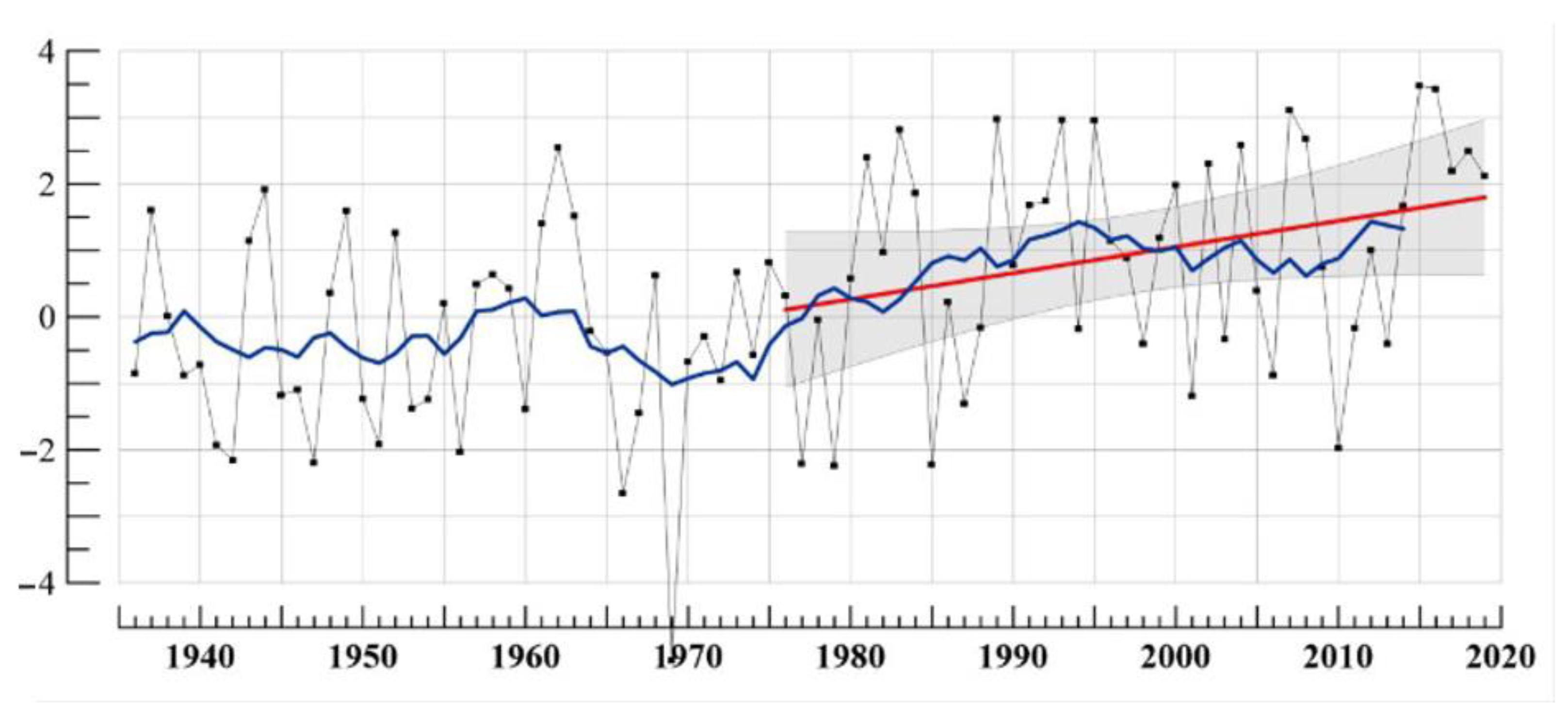
Extensive industrialization of the Russian North, mostly the oil and gas industry, required new methods of construction, and one of them was ensuring the stability of structures by keeping the ground base frozen. It began to be used worldwide once N. Tsytovich had developed necessary studies in 1928 [29]. The method included ventilated cellars under floors and was implemented in Yakutsk in 1937 [30] for the construction of a new power station, which is still operational. A large number of buildings and engineering structures were successfully constructed in the North and the Russian North-East (cities of Vorkuta, Norilsk, Yakutsk, with hundreds of thousands of civilians, etc.). Large oil and gas fields in Western Siberia were in operation and about 200,000 km of main pipelines were constructed. The construction was supported by a network of permafrost monitoring stations funded by the government. The network was functioning until about 1980 when it seemed that all problems with permafrost were basically solved; it seemed that the construction industry in the Russian North, and mostly all around the world, was completely supplied with technologies and materials. Accordingly, the permafrost stations were closed, and scientific studies were gradually reduced. At this time, everything was fine, because this period was also cold. However, climate warming began later, and more rapidly than on average in the Northern Hemisphere (Figure 2).

3.1.2. Modern Monitoring of Permafrost in Nature

Nowadays, automatic measuring instruments of natural physical processes are widely used [32,33]. The development of automatic devices, such as temperature data loggers for recording and storing large volumes of physical characteristics (temperature, humidity, etc.), increased the efficiency of permafrost monitoring. Long-term year-round research in remote regions has become possible. Observers were limited to a short time presence in the summer for taking data and servicing automatic equipment.
Russia took part in two international programs for the study of permafrost: TSP (the Thermal State of Permafrost) and CALM (the Circumpolar Active Layer Monitoring) [26]. It allowed, partly, the restoration of monitoring at some sites (measuring the permafrost temperature at a depth of zero seasonal amplitudes (~10 m); measuring the depth of seasonal soil thawing, as well as partly to recover damaged wells, to drill new ones, and even to establish new sites.
The Institute of the Earth Cryosphere RAS (Russian Academy of Sciences) has several permafrost monitoring sites in Western Siberia. “Tarko-Sale” is located in the northern taiga (left bank of the Pur River, 18 km west from Tarko-Sale (a town), in discontinuous permafrost), “Nadymskaya” near the Nadym-Punga compressor gas pipeline to monitor its impact. “Talnakh” (R32; 69°26′ N, 88°28′ E) is located in the forest tundra.
Three sites were built in the mid-1970s on the territory of the Urengoyskoye oil and gas condensate field, in the forest tundra and the southern tundra. They are located near the center of the planned gathering and treatment points for gas from production wells (Gas Processing Facility). After 45 years, the infrastructure of the GPF has gradually crept up to the sites, but the conditions can still be partially considered background. “The Urengoy-northern forest-tundra” site is located 180 km north from Novy Urengoy (a town) (R50B; 67°28.5′ N, 76°41.5′ E). Soil temperature there has increased over 45 years from 5–6 °C to 3–4 °C.
The Permafrost Department of Lomonosov Moscow State University conducts monitoring in the Vorkuta coal mining region and on the coast of the Baydaratskaya Bay. In 1974, the Institute of Agrochemistry and Soil Science of the USSR Academy of Sciences, together with VSEGINGEO, near Chokurdakh (a town), in the lower reaches of the Indigirka River, equipped monitoring sites to study the thermal regime of permafrost, thaw depth and dynamics of cryogenic processes. At some of the sites, the permafrost parameters are still being measured.
The Abyisky heat-balance station at the Permafrost Institute of the Siberian Branch of the USSR Academy of Sciences was built in the Abyisky region of the Yakut Autonomous SSR in 1984–1986. It researched the heat balance and permafrost conditions of soil in the regions of drained lakes in order to create forage meadows for animal husbandry. In the early 1990s, within the framework of the CALM project, 29 CALM experimental sites were built in the Arctic zone of Eastern Siberia and Yakutia, from the Yenisei River to the Kolyma River, 19 of which are still working.
From 1992 to the present, the Permafrost Institute, Siberian Branch of the RAS, together with a number of international scientific organizations, has held monitoring studies in the vicinity of Tiksi (a town). In 2007, a series of wells equipped with temperature data loggers were drilled in the lower reaches of the Kolyma River, and the monitoring is still being held there. In 2010, the Samoilovsky Island Research Station was built in the Lena River delta to develop research into the Arctic natural environment. Thermal conditions are observed in a series of temperature wells. On the territory adjacent to the station, permanent sites are equipped to monitor the rate of coastal destruction due to thermal erosion and thermal abrasion.
In recent years, the staff of the Permafrost Institute has equipped new monitoring points in the border zone of the North Siberian lowland and the Putorana plateau (between the Kystyktah and Ondodomi rivers), in the coastal part of the Khatanga Bay area of the prospective oil industry, in the interfluve of the Lena and the Olenka rivers, near Zhigansk (a town) (lower reaches of the Lena River). In terms of global warming, results extrapolation led to the identification of areas with a lowering of the permafrost table within the southern forest tundra, and in the northern forest tundra, larch sparse forests move northward.
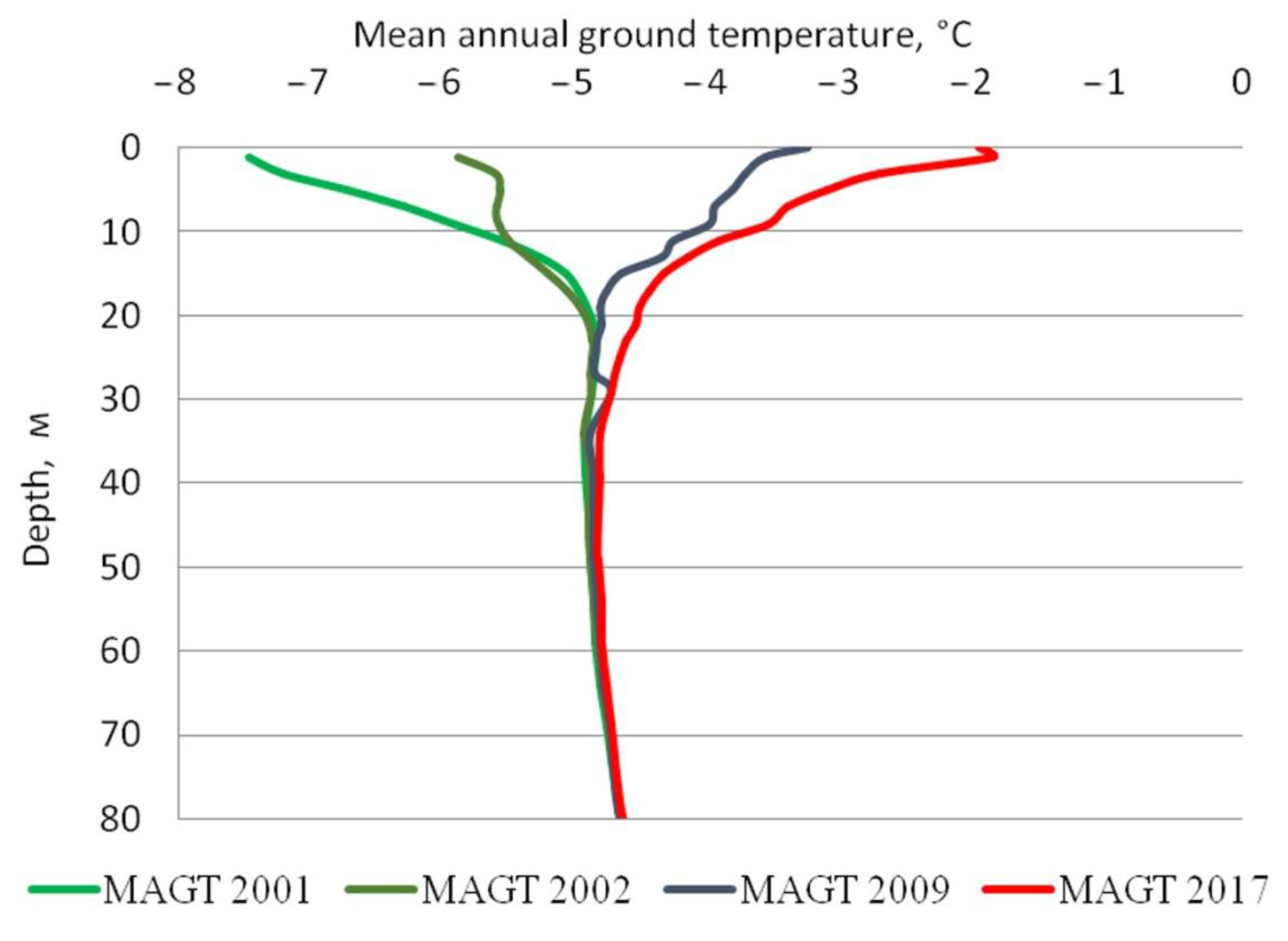
An increase in the mean annual air temperature (MAAT) and winter precipitation has led, in recent decades, to significant changes in the temperature mode of permafrost. Soil temperature in the upper layers for the last 30 years has increased by more than 1.5/2.5 °C in some arears of the Russian Arctic (Figure 3). In the tundra of the European territory of Russia, the permafrost temperature rose to −0.2/−1 °C. In the forest tundra and southern tundra of Western Siberia, at conditions of discontinuous and continuous permafrost, the temperature has increased by more than 1.5 °C over the past 20 years. In Eastern Siberia, the mean annual ground temperature (MAGT) in the Arctic zone during the monitoring increased by an average of 1.5/1.9 °C. Over the past 35–40 years, the background temperature values of the upper part of the permafrost in the coastal lowlands of Western Siberia have increased by 2.0 to 4.0 °C, depending on the geomorphological level. At the same time, an increase was recorded not only in the layer of zero annual amplitudes (10–15 m), but also significantly lower, in depths of 25–30 m.
However, in total, permafrost monitoring remains largely local. Permafrost monitoring in the Central Siberian and Yakutsk sectors of the Russian Arctic are insufficient. There are only five sites for regular control: Igarka, Tiksi, Samoilovsky Island, Chersky and Zhigansk, and none of them are close to areas of oil and gas development. The temperature of permafrost is continuously monitored in three wells located in Anadyr and its environs. Cryogenic processes, the dynamics of seasonal thawing, and the temperature of the active layer are monitored at five sites 100T (100 × 100 m and automatic temperature recording) CALM. Two sites are located in the vicinity of Lavrentiya and Lorino, and three more sites are located in the typical landscapes of the Anadyr lowland.
The system of BM (in undisturbed areas) is represented in various ministries and departments with a limited number of stations and sites of periodic visits. There are only two monitoring objects in the system of the Ministry of Natural Resources—the Vorkuta test site and the Marre-Sale station in Yamal. The Marre-Sale station was built by the VSEGINGEO Institute in 1978 to serve large Russian oil and gas producers and has worked, until lately, as the functions of a field center for approbation of new methods and technical means for monitoring the Arctic permafrost, including the coast and shallow shelf of the Kara Sea. The Russian Academy of Sciences has approximately 20 sites and about 85 wells.
The USA, in Alaska, the territory of which is almost 10-times smaller and less oil and gas rich, has more wells. Canada has the same number of them, but the development of the northern territories, as well as the total permafrost area, is lesser. Switzerland has had the state program for permafrost monitoring and dozens of wells for more than 30 years, as well as Norway (in Svalbard, which the latter runs), and its operator is a research institute. In the United States and Canada, the well-equipped and trained geological services of these countries together with state universities conduct monitoring. In China, the State Scientific Institute monitors about 1000 wells in Tibet.

3.1.3. Modern Permafrost Monitoring at Civil and Industrial Facilities

Various enterprises and organizations monitor the condition of buildings and engineering structures, including production wells, main pipelines and power plants. Geotechnical monitoring (GTM) usually includes measurements of soil temperatures and deformations of buildings and facilities only. GTM is most fully represented at the facilities of the gas industry, more so than in any other spheres of industry, including transport and municipal facilities. Larger companies have already implemented an extensive monitoring (Gazprom—over 12,000 temperature boreholes; Transneft—close to 7000; Novatek—more than 3500).
The pioneer in the organization of the modern permafrost GTM is “Gazprom”. Earlier than others, back in 2003, “Gazprom” realized the need for GTM implementation for managing the gas transmission systems built on frozen grounds. Now, it is mandatory for all enterprises in the company.
The oil and gas industry in the Arctic, with the modern level of knowledge and technology, is one of the largest areas of activity in terms of the degree of transformation in the natural permafrost environment, primarily its conditions [34]. The development of hydrocarbon resources is inevitably accompanied by transformations of permafrost and the natural course of the evolution of northern geosystems. Emergencies caused by the loss of stability of permafrost are associated with a decrease in the bearing capacity of frozen foundations and the expansion of deformations of foundations of structures and technological equipment. In contrast to deformations in objects built on thawed soils, deformations in structures on frozen foundations continue over time, due to the permafrost behavior to man-made impacts.
Failures in the oil and gas complex located in the permafrost zone have shown that most problem situations emerge in the first 2–3 years of operations. The man-made impacts on permafrost are one of the main causes of emergency situations, regardless of the stage of the life cycle of facilities. For instance, at the operating gas production facilities of the Yamburgskoye and Medvezhye fields, the permafrost table at the base of the gas air coolers, depending on the initial cryogenic conditions and operation time, decreased from 1.5–2 m to 7.5–8 m, which sometimes exceeds the piling depth and leads to a loss of the bearing capacity in the foundations.
Main pipelines with a product temperature different from the temperature of the enclosing soils suffer from significant deformations. Man-made taliks are formed around pipelines with a positive temperature of the transported product (+10 °C and more), depending on the methods of thermal insulation, as well as the composition, cryogenic structure and temperature regime of soils in natural conditions, with surface subsidence processes, local thermokarst, thermal erosion along the pipe and often leads to the ascent of the gas pipeline to the Earth surface. Geotechnical problems are relevant for the old production wells, which were constructed amid the absence of sufficient experience in the permafrost zone and without proper methods of thermal insulation of tubing strings. The high positive temperature of the produced gas (up to +36 °C for Cenomanian deposits of Medvezhye Gas field and Urengoyskoye Oil and Gas Condensate field) has a significant warming effect on the permafrost, amid the formation of significant cylindrical thawing halos around the wellbores and the formation of near-mouth craters, but also by the development of thermokarst subsidence at significant areas around the clusters of production wells.
Quite typical is the situation where the increase in the temperature of soils occurs under the influence of excessive man-made influence, for example, under numerous technological fillings. At the same time, the seasonality of thawing and freezing cycles is violated, and the thawing depth itself increases, capturing the underlying natural soil. As a result, thermokarst phenomena and rapid deformations in engineering objects begin [35].
Studies show that the number of deformed buildings and facilities in the permafrost zone now reaches about 40% (Table 1), although criteria for “damaged buildings” vary, as the data are approximate and need to be continued.
GTM is carried out not only at oil and gas facilities, but at some thermal and hydroelectric power plants, large mining enterprises, roads and railways, as well as in cities, such as Yakutsk and Salekhard.
However, as a rule, there is no background monitoring (BM) combined with GTM. It reduces the effectiveness of monitoring and its use results as a basis for the design of new facilities and reconstruction of operating ones. There is also currently no coordination and exchange of information between BM and GTM operators.

3.2. Permafrost Monitoring Development Concept

3.2.1. Principles of Monitoring

The permafrost station is the basis for a permafrost monitoring network, both BM and GTM. Monitoring sites or points are built, where natural (background) territories are studied, as well as disturbed, “man-made” ones. Not only soil temperatures need to be measured, but also soil moisture, the active layer depth, cryogenic processes (heaving, frost cracks, slope soil displacement, etc.), and snow and vegetation cover, which affect the state of permafrost. The important feature of permafrost monitoring is its duration, usually measured in years and decades, due to the trends of changes in soil temperatures, their freezing and thawing becoming traceable. The permafrost monitoring should start before and finish long after the oil and gas field, pipelines and power stations operate.
The monitoring network is based on the construction of observation wells for a comprehensive study of the geological (geocryological, hydrogeological, etc.) section and arrangement of the well for regular monitoring of the temperature of soils. Observation wells, as a rule, are equipped with autonomous measuring systems based on loggers, with temperature recording intervals of one to four, or more, times a day. Geophysical and other remote sensing methods are essential as a part of monitoring. Thermal logs or thermometric data observations in a borehole, in the main types of landscapes and types of frozen deposits, allow researchers to estimate the state and dynamics of the thermal regime of frozen soils at different depths in annual and multi-year cycles. Remote video filming for the study of thermoerosion and thermoabrasion is provided both with helicopters and radio-controlled models of unmanned aerial vehicles.
It is known that the temperature regime of the permafrost table is determined by the radiation balance of the underlying surface, the amount and regime of atmospheric precipitation, especially snow, circulation processes in the atmosphere, humidity of the surface air and other climatic factors, vegetation cover, thermal properties of the ground, etc.
By the beginning of the 1990s, 110 meteorological stations in the northern regions of the country, including 48 stations in Eastern Siberia, monitored the temperature of soils and their upper layers. However, the maximum depth of soil temperature measurement at meteorological stations (1.6 and 3.2 m) is insufficient to solve theoretical and applied geocryological problems and to make a thermal forecast, and should be increased to at least 10 m or 15 m, i.e., to the depth of annual fluctuations of ground temperature. In addition, the locations of wells, for the installation of exhaust thermometers, are selected without taking into account landscape and hydrogeological conditions. For example, in the taiga zone, they are in treeless open areas, and do not correspond to the typical landscape conditions of this zone. During especially humid times, at some meteorological stations, underground waters of the seasonally thawed layer are formed, which cause not only transformation in the soil temperature regime, but also processes of waterlogging and flooding at meteorological stations.
It is necessary to make observations of the active layer dynamics, soil moisture, chemical composition and water table of the suprapermafrost waters of the seasonally thawed layer, and thermal properties of snow and vegetation cover. Back in the 1940s, in the 20th century, Vyacheslav Koloskov pointed out the importance of providing such observations at meteorological stations, especially in permafrost conditions. The list should now be expanded. Greenhouse gas content (CH4 and CO2) at the top of the frozen soils section needs to be assessed.
Representativeness of data taken from meteorological stations is also an issue. In Yakutia, for example, 45 meteorological stations, at 23, of them meteorological sites were transferred to other places (at 4 of them, twice), measured the soil temperature. Meteorological sites at 18 stations in Yakutia were subjected to serious man-made impacts (flooding by inundation and suprapermafrost waters, waterlogging, fires, etc.). Further, 11 meteorological stations had breaks in soil temperature monitoring with different durations. Thus, at the 45 registered meteorological stations in Yakutia, measuring the temperature of the soil, the data from only 22 meteorological stations are representative. Of these, at present, geothermal observations are continued at only 11 meteorological stations.
There are 20 meteorological stations in the Arctic zone of Yakutia, but only 8 held monitoring of the soil temperature at depths of 1.6 and 3.2 m. On one hand, the location of meteorological stations, as a rule, does not allow background monitoring (BM), because the sites are in partly altered, disturbed conditions. On the other hand, monitoring at mereological stations does not allow one to obtain proper data related to the development area and buildings and engineering structures bases.
The well-studied territories of the Russian permafrost are a kind of “key area” for extrapolation and interpolation of information. Research institutions provide regular monitoring of the active layer in the European North and Western Siberia at several sites, located so as to cover all natural and climatic zones. The duration of the systematic observations series of the ground temperature is 25–45 years.
At the beginning, observations on the thickness of the active layer were carried out unsystematically and separately, and they were brought together into a single system after the establishment of the international network “Circumpolar Active Layer Monitoring” (CALM). The duration of the CALM protocol observation series does not exceed 10–20 years. However, CALM data do not include a number of important parameters.
It is relevant to observe other parameters, which are necessary for the permafrost state analysis. Such parameters, besides meteorological ones, soil temperature at different depths up to 30 m and more, deformations of the Earth’s surface and structural elements of buildings and facilities, are the characteristics of snow and vegetation cover, soil moisture in the active layer, moisture conditions on the surface, and thermal properties of the snow, vegetation, soils and grounds. Without these parameters, it is often impossible to determine the cause of the change in the temperature regime of soils and to forecast permafrost conditions.
Considered above, background monitoring of undisturbed areas (BM) is important for understanding the general trends of permafrost, but geotechnical monitoring (GTM) has an unconditional priority. GTM is a system for monitoring, forecasting and managing buildings and engineering structures’ conditions to ensure operational reliability, at all stages of the life cycle. In this case, the concept of geotechnical systems includes a set of interconnected natural objects and technical structures that interact with each other and influence each other, as a result of the functioning of a technical object depending on a natural one, and vice versa.
To control the permafrost state of the geotechnical systems is vital, since permafrost is the leading factor in the development of northern geosystems, and at the same time, it is their most dynamic and unstable component. The reliability of the functioning of the engineering facilities erected on them largely depends on the state of the permafrost. A cumulative effect appears as a result of the combination of modern climate warming and large-scale man-made impacts on permafrost. The consequences of the cumulative effect have already led to the loss of stability of frozen grounds, major accidents of natural and technical systems, ecological disasters and, in general, to an increase in the risk of nature management in the permafrost regions, including the shelf of Arctic seas [38].
The principles of organization and structure in geological and technical measures are largely determined by the specifics of the industry and operating facilities. However, it is necessary to pay attention primarily to the geological structure of the territory and the nature of the environment, as well as monitoring a set of parameters, which makes it possible to carry out a quantitative forecast of the state of the permafrost.
The main goal of geological and technical measures is to ensure the reliability of the functioning of geotechnical systems and the trouble-free operation of engineering facilities. This goal can be achieved in the process of identifying potential areas of geotechnical risk and developing measures to eliminate the causes of critical incidents. Gas production enterprises in the West Siberian fuel and energy complex are often city forming and, along with the administrations of settlements in the Yamalo-Nenets Autonomous Okrug, are interested in trouble-free, long-term and stable operation of not only field engineering facilities, but also civilian facilities. Therefore, services in the geological and technical measures include housing facilities in their area of responsibility or providing methodological support in monitoring the condition of houses and public utilities in Nadym, Novy Urengoy, Salekhard, Labytnangi and other settlements.

3.2.2. Structure of Monitoring

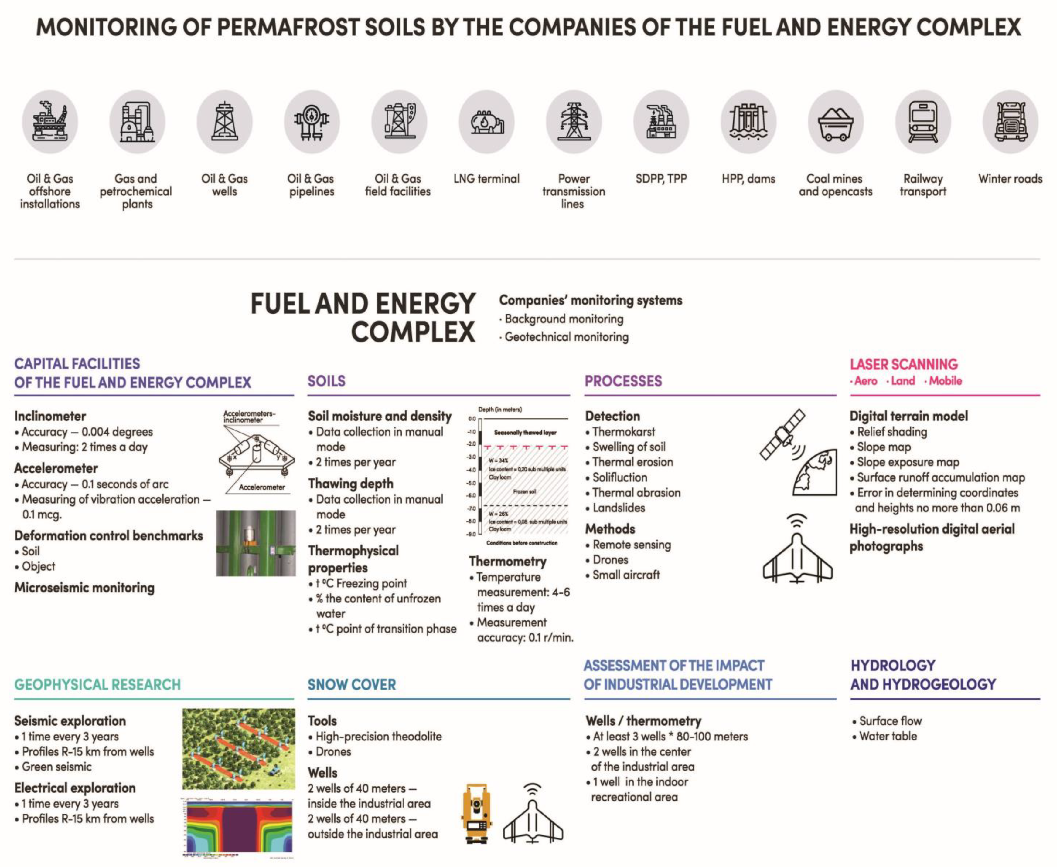
We describe the structure of permafrost monitoring that best matches the experience of the USSR and Russia in this sphere. The new approach aimed to create a system of permafrost sites, as the highest level of monitoring, combining BM stations and GTM facilities of industrial structures, transport systems, urban and municipal entities. The observational network of BM and GTM of permafrost includes: sites, stations, regional profiles and points of periodic visits. The disturbed territories are provided with materials of small–medium-scale integrated engineering–geological and hydrogeological surveys.
Permafrost sites are built both in the territory of prospective economic development, and in the areas of operating industrial and energy complexes, which poses a serious threat to the ecological situation in the region.
The observation network at the test site combines BM and GTM. In general, the territory of the test site is determined by the boundaries of extrapolation and representativeness of the observed regional parameters of the geological environments.
The construction of observation sites involves certain requirements, the main of which are: the prospects for the development of the region as a large industrial and economic facility; the study of the territory or its individual parts, for performing a preliminary typification of the landscape–climatic and permafrost–geological conditions of the region on a small and medium scale; the presence of natural hazards during the development of the territory and, as a consequence, the need for a detailed study of geological conditions on the basis of monitoring observations and research, and the prospects of using scientific and methodological studies and observation results for other regions (Figure 4).
Observation sites should have been created at least 5–7 years before the start of intensive development of the region and the installation of major capital-intensive facilities. The recommended lifetime of landfills should be at least 30–35 years. The territory of the landfill should be sufficient to characterize one (less often two) permafrost zones (subzones), taking into account the variability of nature-forming parameters under the influence of latitudinal zonation and continentality. The territory of the test site should be provided with hydrometeorological information with the longest possible series of observations.
Elements of the observation network of a lower hierarchy (stations, profiles, sites, wells, etc.) function within sites. Additional observation points are built. Routes of ground and remote surveying of the most complex and dynamic monitoring objects are carried out. A feature of the monitoring site is the organization and conduct of observations of the regime of permafrost on regional profiles located in latitudinal and meridional directions. The creation of a permanent spatial-temporal model of a large territory becomes possible, as a rule, not fully provided (or not provided at all) with materials of state geological, hydrogeological and engineering–geological surveys of medium scale [39,40,41].
The scale of regional surveys and maps of permafrost (hydrogeological-engineering-geological) should be at least 1:500,000 with key areas at a scale of 1:100,000 (1:50,000). The site includes one station (for each map sheet at a scale of 1:500,000), a regional profile of 12–16 deep wells, and observation points fixed on the ground. Of the total number of deep wells, at least 2–3 wells are hydrogeological and are passed to the first subpermafrost aquifer, and the rest, 80–120 m deep, are traversed within the main types of terrain (permafrost regions), at all geomorphological levels.
Regional permafrost stations are the basis of the observational network for BM [42,43]. They are built at the stage of advanced permafrost study in the region or at the beginning of the prospecting and appraisal stage of geological exploration, at the rate of one or two stations per landscape subzone. The stations should be located in the largest types of natural complexes in the rank of a landscape (physical–geographical) region or sub-province and include several types of localities (permafrost). Regional stations should be aimed at an operating period at least of 30–40 years, in order to cover the long-period rhythm of permafrost and hydrogeological conditions (Figure 5).
Observation objects in the permafrost station are systems of wells, observation platforms and profiles for studying the thermal and water regime of permafrost layers in annual and multiyear cycles, with an assessment on the influence of the natural factors.
The studied parameters (in the monitoring system at the stations) include: the composition and properties of soils in the frozen and thawed state, and the moisture regime. The total number of boreholes at the station is about 25, 10 of which are deep (up to 80–120 m), and 2 penetrate the entire thickness of the permafrost (Figure 4). The rest of the wells are drilled to a depth of approximately 2–3-times the capacity of the annual heat turnover (30–40 m). Observation sites study the composition and properties of soils, and ground covers (vegetation, snow).
Maps of the station territory are made with factual material (with a diagram of the observational network) and geocryological zoning on a scale of 1:10,000. These maps show the thermophysical and geoecological models of the territory of the station.
The choice of the station location should be based on the materials of regional studies, taking into account the accessibility of the study area, the proximity of settlements and hydrometeorological stations, the availability of electricity, etc. These territories should cover both the most typical I and C complex (including the dominant type) and an I and C complex with the maximum development of permafrost processes.
The geotechnical monitoring observational network is designed by subsoil users, in accordance with the technological features of mining and processing industries, and taking into account the information requirements included in the license agreements for subsoil use. According to our estimates, the deployment of the monitoring system in the Russian Arctic requires about RUB 10–12 billion.

4. Discussion

The system of permafrost background monitoring (BM) is currently represented in Russia in various ministries and departments, by a limited number of stations and sites of periodic visits. Comparison of the Russian BM with other countries shows that northern countries are developing permafrost monitoring on the basis of research and geological institutions [4,44]. The USA and Canada made it on the basis of the Geological Surveys; Switzerland and Norway, on the basis of universities under the state program, and China, on the basis of the Academy of Sciences, jointly with manufacturing enterprises. Observations of undisturbed areas are undoubtedly useful, but they do not reflect the state of permafrost in the area of development or subsoil use [45].
The geotechnical monitoring (GTM) network in Russia is functioning at many industrial, transport and civil facilities. It significantly reduces the risks associated with the interaction of engineering facilities and permafrost. In addition, it prevents the emergence of incidents and significantly reduce operating costs due to timely decisions made on the management of the state of frozen grounds. Meanwhile, the mandatory requirements of such monitoring are far from always being met [4].
In addition, the disadvantage of the existing geological and technical measures system is the lack of background sites in the geological and technical measures network for studying the temperature regime of permafrost in nature and the dynamics of the development of exogenous processes. Despite the arrangement of geotechnical monitoring at a number of large facilities, as well as in some cities (Yakutsk, Salekhard), the absence of simultaneous background monitoring reduces the efficiency of both [45,46].
A common disadvantage of the existing BM and GTM is the absence of observations in the hydrological and hydrogeological regime in the territory, the state and characteristics of snow and vegetation, soil moisture in the active layer, and other important indicators of geosystems. Without them, a quantitative forecast on the state of the eternal permafrost, as well as the decision-making process of ensuring the sustainability of facilities, is impossible [46].
Now, the global permafrost network, authorized by the World Meteorological Organization (WMO) and its associates, consists of two observational components: the Circumpolar Active Layer Monitoring (CALM) and the Thermal State of Permafrost [47]. International requirements for space-based monitoring of permafrost observables were defined within the IGOS Cryosphere Theme Report at the start of the IPY in 2007 [48]. In our opinion, there is still the need to review the requirements for permafrost monitoring and to update these requirements as necessary. For example, land surface temperature, snow depth, and snow water equivalent, soil moisture, vegetation type and height are included as parameters, but its distribution in terms of depth and thermal properties is not.
An integral part of monitoring is not only about observations, but about the analysis of all available data, and primarily, on the foundations of buildings and facilities, and the development of technical solutions for the engineering protection of economic and social facilities; otherwise, they are irrelevant. Such technical solutions are possible only on the basis of a quantitative, scientifically grounded permafrost forecast. Observations, permafrost forecast and development of technical solutions should be carried out on the basis of uniform and tested methods and equipment. However, they have not yet been developed. Besides, the monitoring system still has no structures responsible for forecasting the state of permafrost, and no centers for developing technical solutions to ensure the stability of buildings and engineering facilities on permafrost.

5. Conclusions

Changes in the thermal state of permafrost under the influence of climatic variations have occurred over the years, but have not reached their maximum. This circumstance significantly increases the risks in fuel and energy complex stability. Everywhere in the Russian Arctic, there is a loss of the bearing capacity in the bases of buildings and structures. The vast majority of the permafrost data are outdated and need to be actualized in the formation of a unified monitoring system.
The development of the fuel and energy complex in the Russian Arctic complements the impact of background climate change. As a result of the joint effect of climate warming and large-scale man-made impacts on permafrost, a cumulative effect arises. Its consequences critically accelerate the loss of the stability of frozen foundations, which leads to major accidents of natural–technical systems.
However, nowadays in Russia, there is no single center for the collection and analysis of permafrost information. Even gas and oil companies do not exchange permafrost data. This has resulted in ignorance of the current permafrost processes, at the federal and regional levels, as well as in built-up areas, in cities and towns, in the foundations of engineering facilities. The existing funding of the monitoring network is insufficient for a general assessment of emerging trends, especially amid assessments of possible damage by the mid-century, as a result of an increase in permafrost temperatures.
The establishment of a new state permafrost monitoring system is a timely, economically justified and important national task. It is clear that the developed territories and foundations of buildings and facilities have the highest priority above nature. A number of industrial enterprises (Gazprom, Rosneft, Transneft, Rushydro and others), municipalities (Salekhard, Yakutsk and others), and scientific institutions in the Russian Academy of Sciences and the Ministry of Science are already conducting both background and geotechnical monitoring; therefore, the priority today is to organize interagency cooperation and create a joint coordination and analytical center.

Author Contributions

Conceptualization, A.V.B.; Formal analysis, S.V.B.; Investigation, S.V.B., M.R.S., D.S.D., G.V.M., M.N.Z., O.V.Z., N.A.O., A.B.O., D.O.S., V.A.D., M.E.K., A.G.A., K.N.F. and R.Y.F.; Methodology, V.P.M. and V.I.O.; Visualization, K.N.F.; Writing—original draft, A.V.B.; Writing—review and editing, A.V.B. and R.Y.F. All authors have read and agreed to the published version of the manuscript.

Funding

This research received no external funding.

Informed Consent Statement

Not applicable.

Acknowledgments

This work would not have been possible to conduct without the support of the Government of Yamalo-Nenets Autonomous Okrug and The Ministry for the Development of the Russian Far East and Arctic (Minvostokrazvitiya).

Conflicts of Interest

The authors declare no conflict of interest.

References

  1. Zajhhenko, V.M.; Cernyavskij, A.A.; Novikov, N.L.; Novikov, A.N. Strategy for innovative development of electric power in the Arctic zone of Russia. Energy Policy 2018, 4, 68–79. (In Russian) [Google Scholar]
  2. Balashova, E.S.; Gromova, E.A. Arctic shelf development as a driver of the progress of the Russian energy system. MATEC Web Conf. 2017, 106, 06008. [Google Scholar] [CrossRef] [Green Version]
  3. Menshikov, S.N.; Morozov, I.S.; Melnikov, I.V. Engineering protection of the objects at the Bovanenkovskoe oil and gas condensate field from the impact of hazardous exogenous processes. Nauka I Tekhnika V Gazov. Promyshlennosti 2014, 58, 14–22. (In Russian) [Google Scholar]
  4. Melnikov, V.P.; Osipov, V.I.; Brouchkov, A.V.; Falaleeva, A.A.; Badina, S.V.; Zheleznyak, M.N.; Sadurtdinov, M.R.; Ostrakov, N.A.; Drozdov, D.S.; Osokin, A.B.; et al. Climate warming and permafrost thaw in the Russian Arctic: Potential economic impacts on public infrastructure by 2050. Nat. Hazards 2022. [Google Scholar] [CrossRef]
  5. Melnikov, V.P.; Osipov, V.I.; Brouchkov, A.V.; Badina, S.V.; Velikin, S.A.; Drozdov, D.S.; Dubrovin, V.A.; Zhdaneev, O.V.; Zheleznyak, M.N.; Kuznetsov, M.E.; et al. Decreased sustainability of Russian fuel and energy complex infrastructure in the Arctic as a result of an increase in the average annual temperature of the near-surface layer of the permafrost. Her. Russ. Acad. Sci. 2022, 92, 303–314. [Google Scholar]
  6. Climate in the Russian Federation in 2018. Rosgidromet Report. Available online: http://global-clima-techange.ru/index.php/ru/component/content/article/2189-doklad (accessed on 17 February 2022). (In Russian).
  7. Melnikov, V.P.; Osipov, V.I.; Broushkov, A.V. Assessment of damage to residential and industrial buildings and structures during temperature changes and thawing of permafrost soils in the Arctic Zone of the Russian Federation by the middle of the 21st century. Geoekol. Inzhenernaya Geol. Gidrogeol. Geokriol. 2021, 1, 14–31. (In Russian) [Google Scholar]
  8. Biskaborn, B.K.; Smith, S.L.; Noetzli, J.; Matthes, H.; Vieira, G.; Streletskiy, D.A.; Schoeneich, P.; Romanovsky, V.E.; Lewkowicz, A.G.; Abramov, A.; et al. Permafrost is warming at a global scale. Nat. Commun. 2019, 10, 264. [Google Scholar] [CrossRef] [PubMed] [Green Version]
  9. Kukkonen, I.T.; Suhonen, E.; Ezhova, E.; Lappalainen, H.; Gennadinik, V.; Ponomareva, O.; Gravis, A.; Miles, V.; Kulmala, M.; Melnikov, V.; et al. Observations and modelling of ground temperature evolution in the discontinuous permafrost zone in Nadym, north-west Siberia. Permafr. Periglac. Process. 2020, 31, 264–280. [Google Scholar] [CrossRef]
  10. Streletskiy, D.A.; Suter, L.J.; Shiklomanov, N.I.; Porfiriev, B.N.; Eliseev, D.O. Assessment of climate change impacts on buildings, structures and infrastructure in the Russian regions on permafrost. Environ. Res. Lett. 2019, 14, 025003. [Google Scholar] [CrossRef]
  11. Melnikov, V.P.; Drozdov, D.S.; Pendin, V.V. Arctic Permafrost: Dynamics, Risks, Problems and Solutions. In Proceedings of the 22nd International Science-Practical Conference “New Ideas in Earth Science”, Moscow, Russia, 2–5 April 2015; pp. 123–138. (In Russian). [Google Scholar]
  12. Ezhova, E.; Orlov, D.; Suhonen, E.; Kaverin, D.; Mahura, A.; Gennadinik, V.; Kukkonen, I.; Drozdov, D.; Lappalainen, H.K.; Melnikov, V.; et al. Climatic Factors Influencing the Anthrax Outbreak of 2016 in Siberia, Russia. EcoHealth 2021, 18, 217–228. [Google Scholar] [CrossRef] [PubMed]
  13. Drozdov, D.S.; Malkova, G.V.; Romanovsky, V.E.; Vasiliev, A.A.; Leibman, M.O.; Sadurtdinov, M.R.; Ponomareva, O.E.; Pendin, V.V.; Gorobtsov, D.N.; Ustinova, E.V.; et al. Digital maps of permafrost zone and assessment of current trends of cryosphere changes. In 9 International Symposium on Permafrost Engineering. Book of Abstract; Melnikov Permafrost Institute SB RAS Press: Yakutsk, Russia, 2017; pp. 32–33. (In Russian) [Google Scholar]
  14. Middendorf, A.F. Journey to the North and East of Siberia: In Two Parts; Imperial Academy of Sciences: Saint-Petersburg, Russia, 1860–1878. (In Russian) [Google Scholar]
  15. Sumgin, M.I. Permafrost of Soil within the USSR; Nauka: Moscow, Russia, 1937. (In Russian) [Google Scholar]
  16. Pavlov, A.V. Frost-climate monitoring of Russia: Methodology, observation results, forecast. Kriosf. Zemli Earth’s Cryosphere 1997, 1, 47–58. (In Russian) [Google Scholar]
  17. Baranov, I.Y. Principles of Geocrycological (Permafrost) Zoning of the Region of Permafrost Rocks; Nauka: Moscow, Russia, 1965. (In Russian) [Google Scholar]
  18. Baulin, V.V. Permafrost of the Oil and Gas-Bearing Regions of the USSR; Nedra: Moscow, Russia, 1985. (In Russian) [Google Scholar]
  19. Melnikov, E.S.; Greschischev, S.E. (Eds.) Permafrost and Development of Oil and Gas-Bearing Areas; Geos: Moscow, Russia, 2002. (In Russian) [Google Scholar]
  20. Ershov, E.D. (Ed.) Geocryological Map of the USSR on the Scale of 1:2,500,000; GUGK: Moscow, Russia, 1991. (In Russian) [Google Scholar]
  21. Melnikov, E.S. (Ed.) Geocryological Conditions of the West Siberian Gas-Bearing Province; Nauka: Novosibirsk, Russia, 1983. (In Russian) [Google Scholar]
  22. Baulin, B.B.; Belopuhova, K.B.; Dubkov, G.I.; Shmelev, L.M. (Eds.) Geocryological Conditions of the West Siberian Lowland; Nauka: Moscow, Russia, 1967. (In Russian) [Google Scholar]
  23. Ershov, E.D. (Ed.) Geocryology of the USSR. European Territory of the USSR; Nedra: Moscow, Russia, 1988. (In Russian) [Google Scholar]
  24. Ershov, E.D. (Ed.) Geocryology of the USSR. Western Siberia; Nedra: Moscow, Russia, 1989. (In Russian) [Google Scholar]
  25. Drozdov, D.S. Electronic maps of natural geocryosystems as the basis of the system of territorial monitoring of the geological environment of the Bovanenkovsky and Zapolyarnoye deposits. In Geo-Environmental Mapping: Part 3; Geoinformmark: Moscow, Russia, 2001; pp. 89–91. (In Russian) [Google Scholar]
  26. Manual for Monitoring and Reporting Permafrost Measurements. Part I: Permafrost Borehole Temperatures: Thermal State of Permafrost (TSP). Part II: Active Layer: Circumpolar Active Layer Monitoring (CALM). International Permafrost Association (IPA). 2008. Available online: https://permafrost.gi.alaska.edu/sites/default/files/TSP_manual.pdf (accessed on 3 April 2022).
  27. Drozdov, D.S.; Malkova, G.V.; Ukraintseva, N.G.; Korostelev, Y.V. Permafrost Monitoring of Southern Tundra Landscapes in the Russian European North and West Siberia. In Tenth International Conference on Permafrost; The Northern Publisher: Salekhard, Russia, 2012; Volume 2, pp. 65–70. (In Russian) [Google Scholar]
  28. Melnikov, V.P. (Ed.) Complex Monitoring of Northern Taiga Geosystems in the Western Siberia; Nauka: Novosibitsk, Russia, 2012. (In Russian) [Google Scholar]
  29. Tsytovich, N.A. The Mechanics of Frozen Ground; McGraw-Hill Book Company: New York, NY, USA, 1975. [Google Scholar]
  30. Saltykov, N.I. Buiding Foundations in Yakutsk; Permafrost Institute: Moscow, Russia, 1946; Volume 1, pp. 102–136. (In Russian) [Google Scholar]
  31. Bardin, M.Y. (Ed.) Review of Condition and Trends of Climate Change in Russia; Rosgidromet; RAS: Moscow, Russia, 2019. (In Russian) [Google Scholar]
  32. Hardware and Software Measuring Complex Based on Loggers LPC; Geotechcenter: Moscow, Russia, 2006.
  33. Digital Sensor Controllers Portable PKCD-1/100; Etalon: Omsk, Russia, 2010. (In Russian)
  34. Zhdaneev, O.V. (Ed.) Technical Policy Issues of the Russian Federation Fuel and Energy Complex Branches; Nauka: Moscow, Russia, 2020. (In Russian) [Google Scholar]
  35. Rivkin, F. Integrated regional monitoring methodology. In Modern Research on Cryosphere Transformation and Issues of Geotechnical Safety of Structures in the Arctic; Arctic Science Center: Salekhard, Russia, 2021. (In Russian) [Google Scholar]
  36. Kronik, Y.A. Reliability and Safety of the Foundations of Buildings and Structures on Permafrost. Soil Mech. Found. Eng. 2017, 54, 198–202. [Google Scholar] [CrossRef]
  37. Grebenets, V.; Streletskiy, D.; Shiklomanov, N. Geothecnical safety issues in the cities of Polar regions. Geogr. Environ. Sustain. 2012, 5, 104–119. [Google Scholar] [CrossRef] [Green Version]
  38. Zhdaneev, O.V.; Frolov, K.N.; Konygin, A.E.; Gekhaev, M.R. Exploration Drilling on the Arctic and Far Eastern Shelf of Russia. Arct. Ecol. Econ. 2020, 39, 112–125. (In Russian) [Google Scholar]
  39. Streletskaya, I.D.; Leibman, M.O. (Eds.) Russian permafrost map index. In Workshop on Permafrost Data Rescue and Access; Glaciological Data, Report GD-28; World Data Center for Glaciology: Washington, DC, USA, 1995; pp. 33–114. [Google Scholar]
  40. Yershov, E.D. General Geocryology; Cambridge University Press: Cambridge, UK, 1998. [Google Scholar]
  41. Karjalainen, O.; Aalto, J.; Luoto, M.; Westermann, S.; Romanovsky, V.E.; Nelson, F.E.; Etzelmüller, B.; Hjort, J. Circumpolar permafrost maps and geohazard indices for near-future infrastructure risk assessments. Sci. Data 2019, 6, 190037. [Google Scholar] [CrossRef] [PubMed] [Green Version]
  42. Drozdov, D.S.; Dubrovin, V.A. Environmental problems of oil and gas exploration and development in the Russian Arctic. Kriosf. Zemli 2016, 10, 14–25. (In Russian) [Google Scholar]
  43. Dubrovin, V.A.; Broushkov, A.V.; Drozdov, D.S.; Zheleznyak, M.N. Study, current state, prospects and problems of Arctic cryolithozone development. Mineral resources of Russia. Econ. Manag. 2019, 166, 55–64. (In Russian) [Google Scholar]
  44. Harris, S.; Brouchkov, A.; Cheng, G. Geocryology: Characteristics and Use of Frozen Ground and Permafrost Landforms; CRC Press: London, UK, 2018. [Google Scholar] [CrossRef]
  45. Khrustalev, L.N.; Parmuzin, S.Y.; Emelyanova, L.V. Stability of Northern Infrastructure under Changing Climate; Universitetskaya Kniga: Moscow, Russia, 2011. (In Russian) [Google Scholar]
  46. Kudryavtsev, V.A.; Melamed, V.G.; Garagula, L.S. Fundamentals of Frost Forecasting in Geotechnical Research; Moscow University: Moscow, Russia, 2016. (In Russian) [Google Scholar]
  47. The Global Terrestrial Network for Permafrost (GTN-P). Available online: https://gtnp.arcticportal.org/ (accessed on 4 January 2022).
  48. Alverson, K.; Ryan, B. (Eds.) Integrated Global Observing Strategy Cryosphere Theme Report—For the Monitoring of our Environment from Space and from Earth; World Meteorological Organization: Geneva, Switzerland, 2007. [Google Scholar]
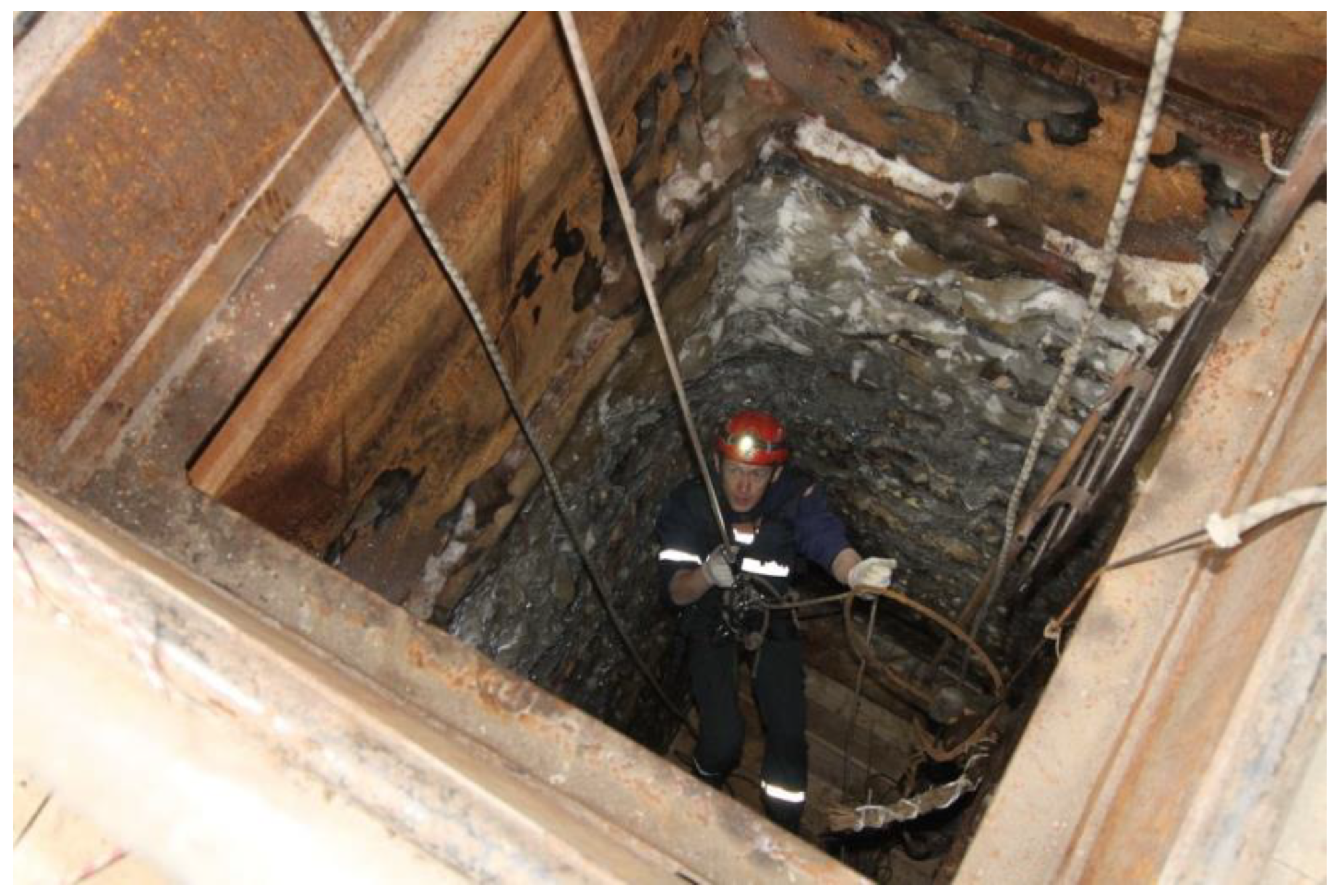
Figure 1. Shergin’s mine, Yakutsk. One of the first temperature measurements of permafrost was carried out here from 1844 to 1846, as part of Alexander Middendorf’s expedition. https://sakhaday.ru/news/kakoj-budet-dalnejshaya-sudba-shahty-shergina (accessed on 3 April 2022).
Energies 15 03190 g001
Figure 2. Mean annual surface air temperature (MAAT) anomalies average for Russia. Source [31].
Energies 15 03190 g002
Figure 3. Mean annual ground temperature (MAGT) changes of permafrost in Western Yamal, borehole 1–95.
Energies 15 03190 g003
Figure 4. Permafrost monitoring structure.
Energies 15 03190 g004
Figure 5. The map of permafrost monitoring sites in Russia.
Energies 15 03190 g005
Table 1. The share of buildings in Russian cities and towns in permafrost regions experiencing deformation. Authors data and [36,37].
City/TownBuildings’ Deformation (%)
Chita60
Pevek50
Amderma40
Dudinka35
Dixon35
Yakutsk˂20
Tiksi22
Anadyr20
Salekhard>10
Labytnangi>10
Vorkuta>50
Publisher’s Note: MDPI stays neutral with regard to jurisdictional claims in published maps and institutional affiliations.