Abstract
The largest ultra-deep (>6000 m) strike-slip fault-controlled oilfield in the world is found in the Tarim Basin of Northwestern China. The localized fractured reservoirs are the major production targets along the strike-slip fault zones. Different from its use in the primary porous-type reservoirs, however, the conventional technology is not favorable for use in oil/gas development in Ordovician carbonate reservoirs. For this reason, high-density seismic acquisition and high-resolution seismic processing were carried out to provide high-precision data for fault and fractured reservoir identification. In addition, the multi-filtering process and the maximum likelihood method are typically used to identify small faults and fault segments along a strike-slip fault zone. Further, seismic facies-constrained inversion and amplitude attributes are favorable for large fracture-cave reservoir description. With the advancements in seismic technology, the high and stable production well ratio has been doubled in the “sweet spots” of fractured reservoir optimization, and the first ultra-deep strike-slip fault-controlled oilfield with an annual oil production of over 1 million tons has been realized, achieving economic development in the ultra-deep fractured reservoirs. However, unstable production and high rates of production decline are still significant challenges in the economic exploitation of the ultra-deep fractured reservoirs. Seismic technology requires further improvement for the description of small fractured reservoirs and matrix reservoirs, as well as reservoir connectivity prediction and hydrocarbon detection in the deep subsurface.
1. Introduction
The ultra-deep (>6000 m) carbonate is enrichment in hydrocarbon resources and has become a major oil/gas exploitation domain in China [1,2,3,4]. However, the ultra-deep carbonate generally exhibits a tight matrix reservoir that hampers the economical exploitation of the large amount oil/gas resources in the deep carbonate [1,4]. In this context, high porous reservoirs are the major drilling targets in the reef-shoal, dolomite, and karstified reservoirs [2]. Further, the “sweet spot” of the fractured reservoir in these basins is a favorable target due to its importance in oil/gas production in the deep subsurface [4,5,6]. The fractured reservoir can increase permeability by 1–3 orders of magnitude and fracture-related porosity by several times in the tight carbonate reservoirs [5,6,7,8,9]. Geological, geophysical, and engineering technologies have been widely used in the description of the fractured reservoirs [7,8,9,10,11]. The seismic technology is of great importance for the “sweet spot” description and well deployment in the deep subsurface [10,11,12]. Owing to intense heterogeneity and the subsequent complicated spatial distribution of this kind reservoir, there is still a big challenge in the identification and drilling of a fractured reservoir in the ultra-deep subsurface. These issues have constrained the economic exploitation of the deep carbonate resources.
The Tarim Basin in Northwestern China contains large quantities of oil/gas resources in the Cambrian-Ordovician carbonates [13,14]. The discovery of hydrocarbon and the exploitation of technology in the ultra-deep carbonates surpass those of other petroliferous basins [15,16,17,18]. The high resolution 3D seismic technology has supported the discovery of the largest carbonate oilfield and the largest condensate field in China [13]. Although large strike-slip fault zones generally occur in plate margins [19,20,21], a large-scale strike-slip fault system was discovered in the central Tarim Basin [14,15,22,23]. The seismic coherence and curvature are used to identify the strike-slip fault, and the seismic amplitude attributes and inversion are favorable for large cave reservoir description [12,15,16,17]. However, the identification of the small fault and fracture networks, as well as small fractured reservoirs, by seismic data is still a major issue in the economic exploitation of the ultra-deep fractured reservoir [12,15,16,17,24,25,26]. Many production wells cannot provide stable economic production despite their initial high output from the fractured reservoirs. The conventional technologies are not adequate to efficiently exploit the large number of reserves from the deep fractured reservoirs in the deep subsurface.
On the basis of recent exploration and development data, we have reviewed the seismic technology advances regarding fractured reservoir exploitation, and analyzed the challenges in the exploitation of the Ordovician carbonate resources in the Tarim intracratonic basin.
2. Geological Background
The Tarim Basin is the largest petroliferous basin in Northwestern China, covering more than 560,000 km2 [13]. It comprises a Cenozoic foreland basin superimposed on a Paleozoic-Mesozoic intracratonic basin, with multi-stages of tectonic evolution, which was influenced by the opening and closing of the Proto- to Paleo-Tethys oceans in the Paleo-Mesozoic era, and the Indo-Asian collision in the Cenozoic period [13,14]. Since 2000, the average depth of a well in the Tarim Basin has been more than 6000 m [13]. The deep Cambrian-Ordovician succession is composed of multiple source rocks and carbonate reservoirs, and is enriched by hydrocarbon resources in the western Tarim Basin [13].
A circum-Aman strike-slip fault system with an area of 90,000 km2 has been found in the central Tarim intracratonic basin (Figure 1) [15]. It comprises the northern uplift, northern depression, and central uplift. The Phanerozoic strata are relatively complete, including a more than 3000 m thickness of Cambrian-Ordovician carbonates in the central Tarim Basin (Figure 1b). There are multi-stage tectonic events, along with multiple unconformities from the Silurian to the Cretaceous eras, along with a Cenozoic quick and deep subsidence in the petroleum system [13,14]. Two sets of source rocks have been documented from the Lower-Middle Cambrian and the Middle-Upper Ordovician periods [13], although there is still hot controversy on the contribution of each source rock. Along with studies of hydrocarbon accumulation history, there are three major stages of oil/gas accumulation: the oil accumulation in the late Caledonian period (Ordovician-Silurian), the accumulation in the late Hercynian period (Permian), and the gas charge in the late Himalayan period (Neogene) [27]. Following multiple tectonic-sedimentary cycles and multistage oil/gas emplacement, more than ten production layers from the Cambrian-Ordovician carbonates and Silurian-Cretaceous siliciclastic rocks have been found in the intracratonic basin [13]. The Ordovician carbonate reservoirs in the central uplift and northern uplift are favorable for oil/gas accumulation and preservation [13,14].
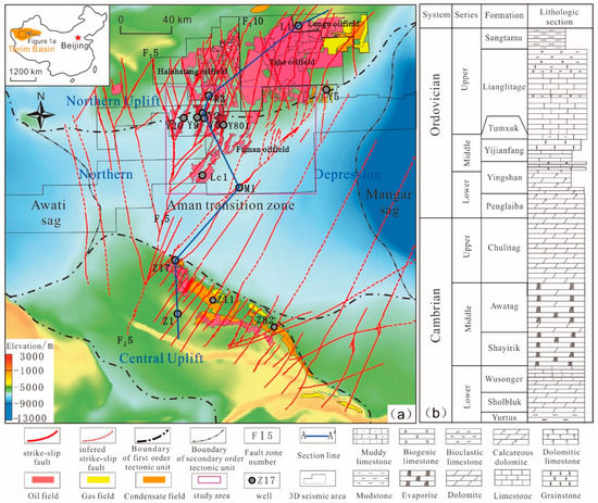
Figure 1.
(a) The strike-slip fault system in the Ordovician carbonates (the figure at the top left corner shows the location of Figure 1a in the Tarim Basin) and (b) the Cambrian-Ordovician stratigraphic column in the Tarim Basin (The strike-slip fault zones are mapped by 3D seismic data, and the color base map shows the topography of the top of the Ordovician carbonate; the oil/gas distribution and tectonic sketch appear as in Reference [26]).
The Middle-Upper Ordovician carbonate rocks are mainly limestone, gradually transitioning to dolomite from the Lower Ordovician to the Cambrian era, with the buried depth of the top Ordovician rocks situated at 5000–9000 m. The Ordovician carbonate oi/gas reserves are mainly distributed along reef-shoal and weathering-crust reservoirs in the southern slope of northern uplift and the northern slope of the Central Uplift in the Tarim Basin, which are attributed to reservoir-controlled stratigraphic traps along the paleo-uplift slope [13]. The porosity from the cores is mostly less than 1.5%, the permeability is generally less than 1 mD, and the porosity from the logging reservoir section generally ranges from 1.2% to 6%, indicating extremely low porosity and a low permeability matrix reservoir. However, the porosity of localized fracture-cave reservoir (consisting of a large cave system and related fractures and vugs that can be identified in the seismic section) is up to 10~50%, and the permeability is more than 5 mD, comprising the main drilling targets [14,15,16]. The production from the carbonate reservoirs varies greatly, with occurrence of simultaneous oil–water or gas–water production. The distribution of water production is not controlled by the localized structural position, but it also differs from the conventional stratigraphic reservoirs, lacking a unified oil–water interface [13,14,15,16].
3. The Exploration Advancement and Characteristics of the Fractured Reservoirs
3.1. The Discovery of the Strike-Slip Fault-Controlled Reservoirs
In the central Tarim Basin, the Ordovician carbonate reservoirs mainly occurred in the karstified reservoirs and reef-shoal reservoirs along the slopes of the paleo-uplifts [13,14]. The previous studies suggest that the paleo-uplift controlled the carbonate reservoir distribution with a large quasi-layered oil/gas reservoir model in the Ordovician carbonates [2,13]. Subsequently, significant exploitation work has been deployed for the deep buried large-scale carbonate reservoirs. However, the deep Ordovician reservoirs in the Tarim Basin are quite different from the high primary porous reservoirs in the Meso-Cenozoic carbonates [13,14]. They have almost secondary porosity, with low porosity (<5%) and permeability (0.5 mD). It is particularly difficult to obtain economical oil/gas production in the ultra-deep limestones.
In this context, the Ordovician fractured carbonate reservoirs have attracted attention regarding carbonate exploration in the Tarim Basin [15,16,17,18]. The strike-slip fault was discovered in 2003, with a subsequent exploration breakthrough from well T82 in the Central Uplift [15]. It has been suggested that the strike-slip fault plays an important role in the reservoir property and oil/gas production [14], but this fact has been argued regarding a small-scale fractured reservoir. Further development has showed that the high-production oil/gas wells are almost always from the fractured reservoirs [28,29]. The “sweet spot” of the fractured reservoir (strong “bead shape” reflection in the seismic section) along the strike-slip fault damage zone has progressively become the major drilling target for carbonate resource development. Since 2010, a series of large-scale strike-slip fault zones have been found in the northern uplift and northern depression [14,15,22,23]. The oil/gas exploitation has exceeded the range of the paleo-uplifts and reached an 8000 m depth in the central depression of the Tarim Basin. The seismic coherence and curvature are used to identify the strike-slip fault, and the seismic amplitude attributes and inversion are favorable for large cave reservoir description [12,15,16,17]. The oil/gas production is mainly from the “sweet spot” of a fracture-cave reservoir along the ultra-deep strike-slip fault zones.
With the 3D seismic exploration, 70 large-scale strike-slip fault zones with a total length of 4000 km have been identified between the northern and central uplifts, which compose the circum-Aman strike-slip fault system with an area of 9 × 10⁴ km2 (Figure 1). Large amounts of hydrocarbon resources have been found in the Ordovician limestone along the strike-slip fault zones. The geological reserves of oil and gas exceed the equivalent of 1 billion tons of oil, forming a fault-controlled petroleum system of more than 5 billion tons of resources in the central Tarim Basin (Figure 1 and Figure 2). At the same time, Fuman Oilfield has achieved an annual oil production of over 2 million tons to become the largest ultra-deep strike-slip fault-controlled oilfield in the world. The Tarim Basin has become a paradigm for ultra-deep strike-slip fault-controlled hydrocarbon exploitation.
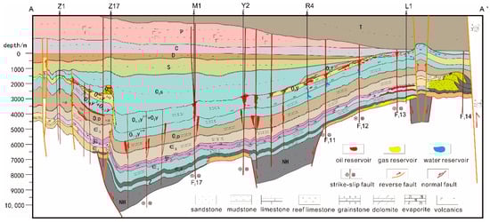
Figure 2.
Reservoir model of the strike-slip fault-controlled petroleum system in the Tarim Basin (flattened from the base of the Carboniferous period; NH: Cryogenian; Z: Sinian; ∈1: Yuertusi Formation; O1p: Penglaiba Formation; O1-2: Yingshan Formation; O2y: Yijianfang Formation; O3l: Late Ordovician Lianglitage Formation; O3s: Late Ordovician Sangtamu Formation; S: Silurian; C: Carboniferous; P: Permian; T: Triassic).
3.2. The Characteristics of the Fractured Reservoir
The early studies proposed large layer carbonate basins of reef-shoal reservoirs and weathered-crust reservoirs in the Ordovician era [13]. However, the matrix porosity of Cambrian-Ordovician carbonate rocks is generally less than 4%, and the permeability is generally less than 0.5 mD (Figure 3). Whatever the lithology, the host rocks lost almost all matrix porosity during the long process of diagenesis. The carbonate reservoirs are extremely heterogeneous, and the physical properties of reservoirs vary greatly in vertical and horizontal directions. These are different from the porous carbonate reservoirs in the Upper Paleozoic-Cenozoic period. The oil/gas reservoirs show low production, as they are lacking fractures. Fault plays a more important role in the reservoirs at the ultra-deep depression. Most wells with high oil/gas production are related to fault zones, and most high production wells are penetrated into large-scale fracture-cave reservoirs. This kind of reservoir shows a porosity of more than 10% and a permeability of more than 5 mD, with many mud leakages and drilling breaks. The exploration and development show that the Ordovician carbonate reservoir distribution is extremely uneven, and it is not a quasi-layered “facies-controlled” reef-shoal reservoir, nor a “stratum-controlled” weathering-crust reservoir [13].
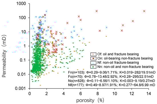
Figure 3.
Correlation between core porosity and permeability in the strike-slip fault zone in the northern Tarim Basin (after reference [7]).
The studies show that there were several periods of short interlayer karstification before the deposition of the Yijianfang Formation, the Late Ordovician, or the Santamu Formation in the Tarim Basin [13,14]. These periods were helpful in the formation of different types of fractured reservoirs along the fault damage zones [7]. In addition, there are multiple weathering-crust karstifications of the Late Caledonian, Early Hercynian, Late Hercynian, and Indosinian periods, as well as multi-period dissolution due to a prolonged burial environment [14]. In the tight carbonate rocks, the strike-slip fault zone is favorable for these karstifications and dissolutions. Superimposed by multiple karstification and burial dissolution processes, multi-stage and multi-type fractured reservoirs are distributed along the strike-slip fault damage zones. The fracture network increases the permeability of the reservoir by 1–3 orders of magnitude (Figure 3). It is noted that the fracture network is suitable for dissolution porosity due to its channel for the meteoric water in the exposure environment and hydrothermal fluid in the burial environment. In this way, there are complicated fractured reservoirs due to the multi-modal pore system, with intense heterogeneous fractures, pores, vugs, and caves along the fault zone. The large-scale fracture-cave reservoirs are mostly differentially distributed along the multi-layer sections of the fracture zone. Various types of fluid–rock interactions may occur along the fault damage zone, forming different dissolution modes and developing large-scale fracture-cave reservoirs (Figure 4a). Reservoirs are more developed along the fault zone, which is the main distribution area of the high-efficiency wells in the Ordovician carbonate (Figure 4b).
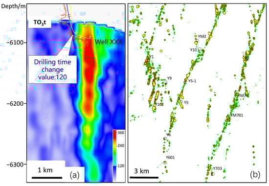
Figure 4.
(a) Tensor thickness attribute sections and related well drilling times showing the boundaries of the fault damage zones and the fracture-cave reservoir (the boundary in the tensor thickness amplitude value is consistent with the drilling time curve); (b) plane amplitude change rate showing fracture-cave reservoirs overlapped with strike-slip faults in the Fuman Oilfield (bright yellow patches are fracture-cave reservoirs).
It is noted that more than 200 wells indicated that the major oil/gas production is from fracture-cave reservoirs in the tight matrix carbonate basins (Figure 4a), although the origin of the dissolution porosity is still ambiguous. Large fracture-caves are also characterized by significantly enlarged borehole diameter, increased natural gamma, and reduced resistivity in the logging data [13]. In the logging interpretation data, the porosity and permeability vary in a large range from 4% to 46% and from 1–1000 mD, respectively. Most of the high production wells have a “bead-shape” reflection (low frequency and strong amplitude reflection of wave crest and trough in the seismic data) in their seismic profiles (Figure 4a). Recent production data revealed that greatest number of high production wells occurred along the fault zones from the scattered “sweet spots” of fracture-caves. Although cores were difficult to obtain from the large caves, the high mud loss, abnormal drilling breaks, and mud overflow indicated that many wells encountered large caves during drilling.
4. Seismic Technical Advances in Description of the Fractured Reservoirs
4.1. High-Density 3D Seismic Acquisition and Processing Technology
In the deep subsurface, it is difficult to describe the small-displacement strike-slip faults and the fractured reservoirs using the conventional 3D seismic technology [15,16]. For this reason, 3D seismic acquisition and processing have been carried out using a small surface element, high fold number, and high-density. Through the analysis of the signal to noise ratio and the relationship between different observations, excitations, and reception schemes under the great desert area, a 3D observation system was proposed to address the issue of fractured reservoir imaging. With the advancements relating to small surface element, high fold number, and high-density seismic acquisition, a suitable high-density 3D seismic acquisition technology has gradually been developed for use in the great desert area. Through the improvement of seismic processing technology, a series of processing methods have been created, allowing for broadening the high frequency and protecting the low frequency, maintaining the relative relationship of amplitudes and protecting the reflected and diffractive wave fields, high-precision shallow surface modeling, high-precision igneous rock modeling, and high-precision well control constraint modeling.
Due to the advancements in high-density seismic acquisition, the trace density has increased up to one million, and the fold number has improved by more than 500 times, and the aspect ratio is increased by more than 0.7. Further, the integration of the processing technology significantly improves the signal-to-noise ratio and the resolution of the seismic data (Figure 5). The first-grade product rate increased from 58% to 81%, and the problem of the accurate imaging of the strike-slip fault zone and fractured-cave reservoirs due to huge surface dunes, deep burial depths, and volcanic influences has been practically eliminated. This is favorable for ultra-deep strike-slip fault-controlled reservoir exploration. Through the application of high-density data, a large number of small faults can be imaged for the detailed description of strike-slip faults. In addition, the number of fracture-cave reservoirs identified could be doubled in the fault zone (Figure 6), which supports reservoir description, along with well deployment.
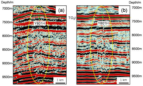
Figure 5.
Comparison between (a) the conventional pre-stack processing depth section and (b) the new processed depth section in the Fuman Oilfield (the yellow circle showing the fault zone; TO3t: base of Upper Ordovician).
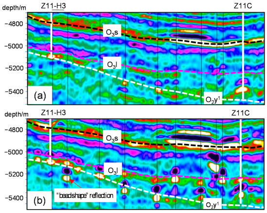
Figure 6.
Comparison of seismic sections between conventional acquisition data (a) and the high-density seismic acquisition data (b) in the central uplift (the “bead shape” reflections showing the large fracture-cave reservoirs; O3t: base of the Upper Ordovician Sangtamu Formation; O3l: base of the Upper Ordovician Lianglitage Formation; O2y1: base of the first member of the Yingshan Formation).
4.2. Identification Technology of Small Strike-Slip Faults
In the early stage, a series of large strike-slip fault zones were identified by seismic profiles and coherent attribute (Figure 1). However, it is difficult to identify the fault segments and small faults.
Combined with the seismic fault modeling, the multiple filtering method was proposed to solved the problem of low-grade fault imaging caused by deeply buried small faults (Figure 7). In this way, the amplitude change rate attribute can solve the strong multi-solution problem of faults in the conventional seismic attributes. It is very useful in identifying small strike-slip faults in ambiguous seismic attributes and sections. Besides seismic coherence data, coherent strengthening, curvature, amplitude change rate, and maximum likelihood are used to identify the small strike-slip faults, which are favorable for the detailed description of small faults and the evaluation of fault segmentation and traps. The maximum likelihood attribute is used to determine the most probable location and probability of the fault in the study area by scanning the similarity between the fracture points in the whole seismic volume and improving the accuracy of fault identification [30]. Compared with the conventional seismic attributes of coherence and curvature, the maximum likelihood attribute can enhance the seismic imaging effect for small faults and fault segments (Figure 8). It has been shown that the secondary faults and the fault segments are more distinct in the maximum likelihood attribute. The fault zone is composed of a series of small faults joined by various linkages. In this way, it is possible to interpret small faults and evaluate each fault segment.
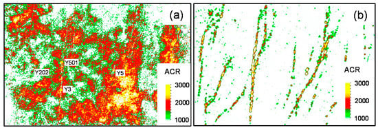
Figure 7.
Comparison of (a) the amplitude change rate diagram of the original data and (b) the amplitude change rate diagram after multiple filtering processes of the top of the Middle Ordovician (ACR: amplitude change rate; modified after reference [16]).
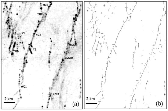
Figure 8.
(a) Planar coherence attributeand (b) maximum likelihood attribute showing the strike-slip faults in a block of the Fuman Oilfield (the dark lines showing fractures).
4.3. Identification of Fractured-Cave Reservoir in Strike-Slip Fault Zone
In recent years, a series of seismic studies have been carried out to describe the fractured reservoirs in ultra-deep strike-slip fault zones [15]. Due to intense dissolution along the fault damage zone, the large fracture-cave reservoirs can be imaged by the amplitude change rate (Figure 4b and Figure 7b) and structure tensor attribute (Figure 4a) [26].
On the basis of strike-slip fault interpretation, a variety of seismic attributes are used to identify and characterize the fractured reservoir distribution; then, the post-stack/pre-stack impedance inversion is used for 3D reservoir sculpture and the analysis of reservoir volume and connectivity. In terms of reservoir inversion, the irregular and heterogeneous reservoirs should be taken into account. On the basis of the wide azimuth and the high-density of the 3D seismic data, the amplitude, frequency, and impedance are helpful for fractured reservoir description. Moreover, the phase-controlled inversion technique is favorable for fractured reservoir prediction (Figure 9). Through the optimal application of fracture-cave reservoir identification technology in the strike-slip fault zone, the drilling and encounter rate of the reservoirs is increased to more than 95%, with a greatly improved drilling success rate as well.
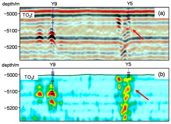
Figure 9.
(a) Original seismic section and (b) the effect of two-facies (seismic facies and sedimentary facies) constrained reservoir inversion for a strike-slip fault zone (the yellow-red block showing fracture-cave reservoirs; TO3t: base of the Upper Ordovician).
In the ultra-deep strike-slip fault-controlled reservoirs, a small number of high output wells support most of the oil/gas production. With the advance in quantitative seismic description technology for fracture-cave reservoirs, the high production well ratio has been increased along the ultra-deep strike-slip fault zones. In addition, the fault segment evaluation in the fault damage zone was carried out to identify the optimal reservoir units, which provided optimized drilling targets and improved the drilling success rate (Figure 4a). Combined with the geological evaluation of the strike-slip fault damage zone, the efficient well location, characterized by “normal landform, long bead shape refection in major fault zone” [15], was also enabled, improving the proportion of high-production wells.
With the development of high-resolution 3D seismic technology, the ultra-deep carbonate reservoir prediction and description have been widely used for well target optimization. Advancements in seismic technology have led to successful reservoir prediction for target optimization through the application of seismic attributes and pre-stack elastic wave inversion. Most wells targeted to the “sweet spots” in large fracture-cave reservoirs obtained high production. By the quantitative description technique of fracture-cave reservoirs, the mud leakage rate increases from 42% to 52.8%, and the reservoir encountering rate increases from 82% to 91% in the northern area. With the advancements in seismic reservoir description technology, more than 90% of high production wells have been penetrated into or close to the large fracture-cave reservoirs, and the success rate of new wells in Fuman Oilfield increased from 75% to 95%, while the efficiency rate increased from 28% to 65%.
5. Technology Challenges for Oil/Gas Exploitation in the Ultra-Deep Carbonate Reservoirs
Although large deposits of oil/gas reserves have been found in the circum-Aman petroleum system, with oil/gas production of more than 6 million t/y from the Ordovician carbonate reservoirs, there are still significant challenges regarding the economic exploitation of the deep carbonate reservoirs.
In the superdeep subsurface, the “sweet spots” of large fracture-cave reservoirs are the main targets for well deployment. Using the high-resolution 3D seismic data, most “bead shape” reflections have been drilled successful in fracture-cave reservoirs. However, other types of seismic reflections do not provide adequate descriptions for deploying wells in fracture-cave reservoirs, and particularly in matrix reservoirs. In addition, some wells penetrating fracture-cave reservoirs do not produce oil/gas, but instead, yield a great deal of water. Despite many more reserves being located in the matrix reservoirs, the seismic reservoir description technique cannot meet the requirements for well optimization under these conditions. In this context, the development of different techniques in high resolution and high-density seismic data acquisition and processing is urgent for reservoir identification in regards to fracture zones, small caves, and suitable matrix reservoirs.
The oil/gas detection and prediction by seismic data are also important for well employment. So far, unpredictable production and water flooding are big challenges for reservoir development. More than 30% of wells cannot be put into production, and most wells exhibit low production rates, even during the initial production period. In order to increase the oil/gas production from the “sweet spot” fractured reservoirs, the fracture network identification from the seismic data is of great importance along the fault zones. On this basis, seismic attributes and maximum likelihood, based on structurally guided filtering, are used to identify small scale fracture networks (Figure 8). These methods have been used in well employment. However, the reliability of the fracture identification techniques requires further study and improvement. In addition, it is urgent to address the reservoir connectivity along the fault damage zone during well employment and oil/gas production. As the large fracture-cave reservoir of “bead shape” seismic reflection has been drilled in the oil/gas fields, the connectivity between the small vug-cave reservoirs has becoming more important for highly deviated and horizontal well employment to increase economic production from the deep subsurface.
6. Conclusions
Despite the complicated characteristics of the Ordovician carbonate reservoirs and oil/gas production in the Tarim Basin, we can propose the following main conclusive points.
- Localized highly permeable fractured reservoirs are the major production targets along the strike-slip fault zones in the Ordovician carbonate.
- High-density seismic acquisition and high-resolution seismic processing provide high-precision data for fault and fractured reservoir identification in the ultra-deep carbonate.
- There has been significant seismic technological progress in the identification of small faults by using a multi-filtering process and a maximum-likelihood method, as well as fracture-cave reservoir description through the use of seismic facies constrained inversion and amplitude attributes along the ultra-deep strike-slip fault zones.
- With the advancement of seismic technology, the first ultra-deep strike-slip fault-controlled oilfield with an annual oil production over 1 million tons has been realized, achieving economic exploitation in the ultra-deep fractured reservoirs.
- The economic exploitation of the ultra-deep fractured reservoirs is still challenging, and seismic technology requires further improvement for the description of small fractured reservoirs and matrix reservoirs, as well as reservoir connectivity prediction and hydrocarbon detection in the deep subsurface.
Author Contributions
Conceptualization, Q.W. and Y.Z. (Yintao Zhang); methodology, Y.Z. (Yintao Zhang) and Z.X.; software, C.S.; investigation, C.Z. and G.W.; data curation, Z.X., Y.Z. (Yawen Zhao) and G.W.; writing, G.W. and C.Z.; visualization, Y.Z. (Yawen Zhao) and C.S.; supervision, Q.W. and Y.Z. (Yintao Zhang); funding acquisition, Q.W. and Y.Z. (Yintao Zhang). All authors have read and agreed to the published version of the manuscript.
Funding
Funding for this study was provided, in part, by the Prospective Basic Research Project of CNPC (2021DJ1502) and the National Natural Science Foundation of China (Grant No. 91955204).
Institutional Review Board Statement
Not applicable.
Informed Consent Statement
Not applicable.
Data Availability Statement
Not applicable.
Acknowledgments
The authors thank the editor and reviewers for their comments regarding manuscript improvement. We also thank Jianfa Han, Shiyin Li, Yongfeng Zhu, Xinwei Chen, and Jingyi Yuan for their assistance with the data.
Conflicts of Interest
The authors declare no conflict of interest.
References
- Sun, L.D.; Zou, C.N.; Zhu, R.K.; Zhang, Y.H.; Zhang, S.C.; Zhang, B.M.; Zhu, G.Y.; Gao, Z.Y. Formation, distribution and potential of deep hydrocarbon resources in China. Pet. Explor. Dev. 2013, 40, 687–695. [Google Scholar] [CrossRef]
- Zhao, W.Z.; Shen, A.J.; Hu, A.P.; Zhou, J.G.; Ni, X.F. A Discussion on the geological background of marine carbonate reservoirs development in Tarim, Sichuan and Ordos Basin, China. Acta Petrol. Sin. 2015, 11, 3495–3508, (In Chinese with English Abstract). [Google Scholar]
- Pang, X.Q.; Jia, C.Z.; Wang, W.Y. Petroleum geology features and research developments of hydrocarbon accumulation in deep petroliferous basins. Pet. Sci. 2015, 12, 1–53. [Google Scholar] [CrossRef]
- Ma, Y.S.; He, D.F.; Cai, X.Y.; Liu, B. Distribution and fundamental science questions for petroleum geology of marine carbonate in China. Acta Petrol. Sin. 2017, 33, 1007–1020, (In Chinese with English Abstract). [Google Scholar]
- Yang, H.J.; Wu, G.H.; Scarselli, N.; Sun, C.H.; Qing, H.R.; Han, J.F.; Zhang, G.W. Characterization of reservoirs, fluids, and productions from the Ordovician carbonate condensate field in the Tarim Basin, northwestern China. AAPG Bull. 2020, 104, 1567–1592. [Google Scholar] [CrossRef]
- Méndez, J.N.; Jin, Q.; González, M.; Zhang, X.D.; Lobo, C.; Boateng, C.D.; Zambrano, M. Fracture characterization and modeling of karsted carbonate reservoirs: A case study in Tahe oilfield, Tarim Basin (western China). Mar. Pet. Geol. 2020, 112, 104104. [Google Scholar] [CrossRef]
- Wu, G.H.; Zhao, K.Z.; Qu, H.Z.; Nicola, S.; Zhang, Y.T.; Han, J.F.; Xu, Y.F. Permeability distribution and scaling in multi-stages carbonate damage zones: Insight from strike-slip fault zones in the Tarim Basin, NW China. Mar. Pet. Geol. 2020, 114, 104208. [Google Scholar] [CrossRef]
- Liu, G.P.; Zeng, L.B.; Han, C.Y.; Ostadhassan, M.; Lyu, W.Y.; Wang, Q.Q.; Zhu, J.W.; Hou, F.X. Natural fractures in carbonate basement reservoirs of the Jizhong Sub-Basin, Bohai Bay Basin, China: Key aspects favoring oil production. Energies 2020, 13, 4635. [Google Scholar] [CrossRef]
- Moore, P.J.; Fernández-Ibáñez, F. Non-Matrix Quick Pass: A rapid evaluation method for natural fractures and karst features in core. Energies 2022, 15, 4347. [Google Scholar] [CrossRef]
- Benmadi, M.; Sayantan, G.; Roger, S.; Kurt, M.; Mashhad, F. Practical aspects of upscaling geocellular geological models for reservoir fluid flow simulations: A case study in integrating geology, geophysics, and petroleum engineering multiscale data from the Hunton Group. Energies 2020, 13, 1604. [Google Scholar]
- Babasafari, A.A.; Chinelatto, G.F.; Vidal, A.C. Fault and fracture study by incorporating borehole image logs and supervised neural network applied to the 3D seismic attributes: A case study of pre-salt carbonate reservoir, Santos Basin, Brazil. Pet. Sci. Techn. 2022, 40, 1492–1511. [Google Scholar] [CrossRef]
- Li, X.; Li, J.; Li, L.; Wan, Z.; Liu, Y.; Ma, P.; Zhang, M. Seismic wave field anomaly identification of ultra-deep heterogeneous fractured-vuggy reservoirs: A case study in Tarim Basin, China. Appl. Sci. 2021, 11, 11802. [Google Scholar] [CrossRef]
- Du, J.H. Oil and Gas Exploration of Cambrian-Ordovician Carbonate in Tarim Basin; Petroleum Industry Press: Beijing, China, 2010. (In Chinese) [Google Scholar]
- Wu, G.H.; Pang, X.Q.; Li, Q.M.; Yang, H.J. The Structural Characteristics of Carbonate Rocks and their Effects on Hydrocarbon Exploration in Craton Basin: A Case Study of the Tarim Basin; Science Press: Beijing, China, 2016. (In Chinese) [Google Scholar]
- Wang, Q.H.; Yang, H.J.; Wang, R.J.; Li, S.Y.; Deng, X.L. Discovery and exploration technology of fault-controlled large oil and gas fields of ultra-deep formation in strike slip fault zone in Tarim Basin. China Pet. Explor. 2021, 26, 58–71, (In Chinese with English Abstract). [Google Scholar]
- Jiang, T.W.; Chang, L.J.; Deng, X.L.; Li, S.Y.; Wu, G.H.; Wan, X.G.; Guan, B.Z. Geological understanding and evaluation technology of fault controlled carbonate reservoir development: A case study of the Tarim Basin. Nat. Gas Ind. 2021, 41, 1–9, (In Chinese with English Abstract). [Google Scholar]
- Ma, Y.S.; Cai, X.Y.; Yun, L.; Li, Z.J.; Li, H.L.; Deng, S.; Zhao, P.R. Practice and theoretical and technical progress in exploration and development of Shunbei ultra-deep carbonate oil and gas field, Tarim Basin, NW China. Pet. Explor. Dev. 2022, 49, 1–17. [Google Scholar] [CrossRef]
- He, X.; Wang, R.; Yang, J.; Li, S.; Yan, C.; Wu, G. Optimization of oil productivity from the ultra−depth strike−slip fault−controlled carbonate reservoirs in northwestern China. Energies 2022, 15, 3472. [Google Scholar] [CrossRef]
- Sylvester, A.G. Strike-slip faults. GSA Bull. 1988, 100, 1666–1703. [Google Scholar] [CrossRef]
- Leighton, M.W.; Kolata, P.R.; Oltz, D.F.; Eidel, J.J. Interior Cratonic Basins; AAPG Memoirs: Tulsa, OK, USA, 1990; p. 51. [Google Scholar]
- Cunninghan, W.D.; Mann, P. Tectonics of Strike-Slip Restraining and Releasing Bends; Special Publications; Geological Society: London, UK, 2007; p. 290. [Google Scholar]
- Deng, S.; Li, H.L.; Zhang, Z.P.; Zhang, J.B.; Yang, X. Structural characterization of intracratonic strike-slip faults in the central Tarim Basin. AAPG Bull. 2019, 103, 109–137. [Google Scholar] [CrossRef]
- Yang, H.J.; Wu, G.H.; Han, J.F.; Su, Z. Structural analysis of strike-slip faults in the Tarim intracratonic Basin. Chin. J. Geol. 2020, 55, 1–16, (In Chinese with English Abstract). [Google Scholar]
- Yang, X.W.; Wang, R.J.; Deng, X.L.; Li, S.Y.; Zhang, H.; Yao, C. Theoretical exploration and practice of water injection gravity flooding oil in ultra-deep fault-controlled fractured-cavity carbonate reservoirs. Pet. Explor. Dev. 2022, 49, 133–143. [Google Scholar] [CrossRef]
- Li, Z.J.; Wang, Y.; Yang, Z.C.; Li, H.Y.; Yu, G.M. Identification of fractured carbonate vuggy reservoirs in the S48 well area using 3D 3C seismic technique: A case history from the Tarim Basin. Geophysics 2019, 84, 59–74. [Google Scholar] [CrossRef]
- Wang, R.; Yang, J.; Chang, L.; Zhang, Y.; Sun, C.; Wan, X.; Wu, G.; Bai, B. 3D Modeling of Fracture-Cave Reservoir from a Strike-Slip Fault-Controlled Carbonate Oilfield in Northwestern China. Energies 2022, 15, 6415. [Google Scholar] [CrossRef]
- Yang, S.; Wu, G.H.; Zhu, Y.F.; Zhang, Y.T.; Zhao, X.X.; Lu, Z.Y.; Zhang, B.S. Key oil accumulation periods of ultra-deep fault-controlled oil reservoir in northern Tarim Basin, NW China. Pet. Explor. Dev. 2022, 49, 249–261. [Google Scholar] [CrossRef]
- Wu, G.H.; Yang, H.J.; He, S.; Cao, S.J.; Liu, X.; Jing, B. Effects of structural segmentation and faulting on carbonate reservoir properties:case study from the Central Uplift of the Tarim Basin, China. Mar. Pet. Geol. 2016, 71, 183–197. [Google Scholar] [CrossRef]
- Jiang, T.W.; Han, J.F.; Wu, G.H.; Yu, H.F.; Su, Z.; Xiong, C.; Chen, J.; Zhang, H.F. Differences and controlling factors of composite hydrocarbon accumulations in the Tazhong uplift, Tarim Basin, NW China. Pet. Explor. Dev. 2020, 47, 229–241. [Google Scholar] [CrossRef]
- Ma, D.B.; Zhao, Y.M.; Zhang, Y.T.; Yang, P.F.; Yang, M.; Li, L. Application of maximum likelihood attribute to fault identification: A case study of Rewapu block in Halahatang area, Tarim Basin, NW China. Nat. Gas Geosci. 2018, 29, 817–825, (In Chinese with English Abstract). [Google Scholar]


Publisher’s Note: MDPI stays neutral with regard to jurisdictional claims in published maps and institutional affiliations. |
© 2022 by the authors. Licensee MDPI, Basel, Switzerland. This article is an open access article distributed under the terms and conditions of the Creative Commons Attribution (CC BY) license (https://creativecommons.org/licenses/by/4.0/).