Abstract
A giant, ultra-deep (>7000 m) strike-slip fault-related oilfield has been found in the central depression of the Tarim Basin. However, little research has addressed this discovery to understand the fault effects on the oil migration, which constrains the oil exploitation deployment and well optimization. Based on fault modeling and fluid analysis, we present the effects of fault segment on the oil segmentation and migration in the ultra-deep Fuman Oilfield. The results show a distinct fault segmentation and also subsequent variable fault architecture and non-connected fracture network other than a through-going fault zone. There are fault segment-related isolated fractured reservoirs and fluid variation along the fault strike, which indicates that a large oilfield comprises a series of unconnected small oil reservoirs along the fault segments. The fluid segmentation and molecular indicator of dibenzothiophenes reveal that there is a variable petroleum lateral migration along the strike-slip fault segment. The fault segmentation is a major contribution in the varied oil accumulation along the strike-slip fault zone in Fuman Oilfield. This case study suggests that fault segmentation has variable effects on petroleum migration and accumulation along the strike-slip zone.
1. Introduction
With the rapid decreasing in shallow hydrocarbon resource, the deep (>4500 m) buried carbonate oil/gas resource has become the major exploitation domain [1,2]. However, the deep carbonate generally has a tight reservoir and complicated oil/gas distribution that constrain the economical exploitation [1,2,3]. In the deep, tight carbonate reservoirs, natural fractures can increase the permeability more than one order of magnitude, and contribute significantly to porosity improvement by the secondary dissolution porosity along the fracture network [3,4,5,6]. Hence, fractured reservoirs contribute significantly to petroleum reserves and economic production in deep subsurface. Modeling of fractured reservoirs has been studied by geological, geophysical and engineering methods [6], whereas the fracture network has complicated spatial architecture, which results in its intense heterogeneity and, in turn, complicated fluid migration and accumulation [7,8,9,10,11]. Geological and geochemical data and numerical simulation have been used to decipher the oil migration along the complicated fracture network in the subsurface [11,12,13,14,15]. Owing to the lack of data on the heterogeneous fracture architecture, fracture network modeling and its related fluid flow in the deep subsurface are still challenging. In this context, there is still little understanding on the fractured reservoirs, which, in turn, constrains hydrocarbon exploitation from the deep fractured reservoirs.
The Tarim Basin in northwestern China is enriched with hydrocarbon resources in the deep Cambrian–Ordovician carbonate rocks [16]. Due to the tight matrix reservoir not being able to support the economic production, the fractured carbonate reservoir has become a major drilling target in the deep tight reservoir [17,18]. Recently, the largest ultra-deep (>7000 m) strike-slip fault-controlled oilfield, Fuman Oilfield, was found in the central Tarim Basin [18]. The petroleum geological reserves exceed 1 × 10⁹ t, and the annual oil production has more than 2 × 10⁶ t [18,19]. At ultra-deep conditions, the commercial production mainly comes from large-scale fracture-cave reservoirs [4,5,6]. Several 3D seismic surveys have been used to describe the large-scale fracture-cave reservoirs [18,20,21]. The fracture-cave reservoirs are localized “sweet spots” in the tight matrix carbonate (porosity < 3%, permeability < 0.5 mD) along the strike-slip fault zones [20,21,22,23]. High oil productions obtained from the Ordovician carbonate rocks along strike-slip fault zones [18,19,20,21,22,23,24]. However, complicated oil/gas/water occurrence and unstable production exist along the strike-slip fault zones. The complicated oil–water relationship is irrelevant with the localized structural trap or reservoir physical properties. The oilfield was characterized by complicated and unstable production, and ~30% high production wells support more than 70% production [19,25]. These are generally attributed to the complicated petroleum migration and accumulation along the strike-slip fault zones [23,24,25,26,27]. Due to sparse data to decipher the fault effect on the oil migration along a strike-slip fault zone, it is still an enigma in the variable oil enrichment in the oilfield, which hampered the high production well deployment and economical exploitation in the deep subsurface.
This paper contributes by presenting the detailed fault segment along the strike-slip fault zones in Fuman Oilfield. On the compiled statice and dynamic data, we analyze the oil property and reservoir changes with the fault segment. Further, we provide geochemical parameters to reveal oil migration and discuss the oil migration model in the oilfield. Finally, we discuss the fault effects on oil migration to provide insights for the exploitation along the strike-slip fault-controlled oil reservoirs.
2. Geological Setting
The Tarim Basin in northwest China has Pre-Cryogenian crystalline basement and is overlain by more than 15,000 m-thick Cryogenian–Cenozoic sedimentary strata [28,29]. During the Cambrian–Ordovician period, a large 3000 m-thick carbonate platform formed in the central-western area. There is fairly uniform carbonate succession deposited in the inner platform, mainly of dolomites in the Cambrian–Lower Ordovician and progressively changing to limestones in the Middle-Upper Ordovician [16]. The basin experienced a multi-stage sedimentary–tectonic evolution, resulting in multiple unconformities and faults, and inherited development of the Paleozoic EW-trending Northern Uplift and NW-trending Central Uplift (Figure 1) [28,29]. During the closure of the proto-Tethys Ocean in the Middle Ordovician-Silurian, the EW-trending Northern Uplift and NW-trending Central Uplift formed by the southern regional compression, and subsequent denudation and multiple unconformities, as well as a series of thrust faults and strike-slip faults developed in the central basin (Figure 1) [29,30]. The Carboniferous–Permian deposited shallow sea to terrestrial strata during the closure of the South Tianshan Ocean and, in turn, peripheral uplifting in the northern Tarim terrane [29]. The Tarim evolution was influenced by the Tethys Ocean opening and closing in the south. During the Mesozoic, there were multiple collision events from the southern Qiangtang and Lasa terranes with the closure of the paleo-Tethys Ocean [28]. Multiple --revised as fault systems and multiple unconformities formed in the basin. With the Cenozoic progressive Indo-Asian collision, the southern and northern peripheral foreland basins developed, and the central area was deeply buried and settled in the Tarim terrane [28].
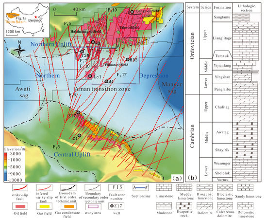
Figure 1.
(a) The strike-slip fault system in the Ordovician carbonates (the figure at the top left corner showing the location of Figure 1a in the Tarim Basin) and (b) the Cambrian–Ordovician stratigraphic column in the Tarim Basin (the strike-slip fault zones are mapped by 3D seismic data [30], while the color base map showing the topography of the top of the Ordovician carbonate, the oil/gas distribution and the tectonic sketch are in accordance with reference [18]).
The strike-slip faults developed and formed a circum-Aman strike-slip fault system in the central Tarim (Figure 1) [30]. From south to north, the strike-slip fault system is divided into three regions: northern Central Uplift, Aman Transition Zone and southern North Uplift. The NE-trending strike-slip faults occurred in the most area, but a conjugate fault set by NE- and NW-trending strike-slip faults developed in the southern slope of the North Uplift. The length of large strike-slip fault zone is more than 80 km, but the horizontal displacement is generally less than 400 m. In seismic profiles, the strike-slip faults are mainly distributed in the Cambrian–Ordovician carbonates. The strike-slip faults formed in the Middle–Late Ordovician with transpressional faults developed in the Cambrian–Ordovician carbonates, and some inherited transtensional faults in the Silurian-Middle Devonian and those partially inherited developed during the Permian and Mesozoic [30,31].
Lower Paleozoic carbonates are enriched in hydrocarbon resource and multiple reservoir-cap assemblages in the Tarim Basin [16]. The oil/gas reservoirs are mainly found in the Middle-Lower Ordovician Yijianfang Formation–Yingshan Formation and the Upper Ordovician Lianglitage Formation (Figure 1). There are two sets of source rocks in the Lower-Middle Cambrian and the Middle-Upper Ordovician. Recently, the borehole data and study suggested that the Lower Cambrian shale is the major source rocks [32,33]. The studies revealed that there are generally oil/gas accumulation stages in the Late Ordovician-Silurian and Permian, a gas charge stage in the Neogene, and hydrocarbon adjustment and loss stages in the Silurian–Devonian and Triassic–Cretaceous [16,26,27,29]. By detailed fluid inclusion association (FIA) analysis, Yang et al. (2022) suggested that the key oil accumulation is occurred in the Late Ordovician and followed an oil adjustment in the Permian in Fuman Oilfield [27]. During the Middle–Late Ordovician, the strike-slip faults initiated contemporaneous with carbonate fracture-cave reservoirs development along the fault damage zone. Meanwhile, the major source rock of the Lower Cambrian entered its peak oil generation period during the quick subsidence of more than 1500 m Late Ordovician mudstone. A large quantity of oil resources was emplaced in the carbonate reservoirs in the central Tarim Basin at the end of the Ordovician [27]. The oil reservoirs could have been preserved along the strike-slip fault zones in the deep depression, but most of the resources were lost in the paleo-uplift by the cap rock denudation and fault activity [29]. There was a oil/gas recharge and adjustment stage during the Permian, when there was more oil accumulation in the paleo-uplift than in the depression [16]. During the Himalayan, there was gas emplacement from the eastern to western area and, in turn, gas enrichment in the eastern area but oil preservation in the western area [16,29]. Subsequently, the oil resource is enriched along the strike-slip fault zone in the deep depression [18], but controlled by the localized reservoirs along the Ordovician carbonate unconformity and the reef-shoal body in the slopes of the northern and central uplifts [16].
3. Date and Methods
More than 10,000 km2 3D seismic surveys have been acquired in the study area. The prestack time migration seismic dataset in the Ordovician carbonates are used for structural mapping and seismic reservoir prediction [20,21]. The fault with vertical displacement more than 10 m could be identified from the seismic sections. However, the faults with small displacement are difficult to identify, and the fault terminal and linkage is hard to mapping by low-resolution seismic data in the ultra-deep subsurface. In this way, seismic attributes such as coherence, curvature, ant body and likelihood are used to map strike-slip fault [18,20,21], and fault segment modeling and the vertical throw along the fault strike are helpful for fault segment identification [34].
Generally, the large-scale fracture-cave reservoirs along the strike-slip fault zones are the major oil reservoirs that can be mapped by the seismic amplitude attributes and reservoir inversion [18,19,20,21]. These methods are used to describe the carbonate reservoirs and correlated with the fault segments along the strike-slip fault zone. Owing to the fluid compartment varied along the fault zone [4,16,29], we collected oil/gas/water property and geochemical data for the analysis of the fluid compartment with the strike-slip fault segmentation. The production data from more than 200 wells are used to analyze the fault effect on oil production. The relative concentration of methyldibenzothiophenes (MDBTs) and dimethyldibenzothiophenes (DMDBTs) is controlled by maturations levels, as well as by migration fractionation effects [35]. The molecular indicators, namely, 4-/1-MDBT, 2,4-/1,4-DMDBT, and 4,6-/1,4-DMDBT are used to trace oil migration pathways [14,35,36]. Together with all the data pertaining to high production varied along the fault segments, we discuss oil migration and enrichment along the strike-slip fault segment.
4. Segmentation of Strike-Slip Fault Zone
A large strike-slip fault system with 9 × 10⁴ km2 area has been found in the central Tarim Basin (Figure 1) [18]. In Fuman Oilfield, in the central depression (Figure 2), strike-slip faults usually have high and steep fault planes. Most faults penetrate to the basement and spread upward at the top of the Middle Ordovician carbonates, but some secondary faults terminated at the Devonian and even in the Permian. At the top of the Middle Ordovician carbonates, the positive flower structure suggested a tranpressional fault activity, sharing the features of “compression, thrusting and antiformal” [29]. In some large fault zones, there are still a few transtensional fault segments to show minimal graben in the Ordovician carbonate. They are mostly of inherited transtensional faults in the Silurian–Devonian, and some developed into Carboniferous–Permian. These are mainly en échelon structures and linear structures in the Silurian–Permian.
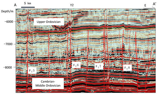
Figure 2.
Typical seismic section showing strike-slip faults in Fuman Oilfield.
The major strike-slip fault zone can be mapped by the coherence and amplitude attributes at the top of the Middle Ordovician carbonate (Figure 3a), but the segmentation is ambiguous. By the fault throw mapping at the top of the Middle Ordovician carbonate [34], the fault zone presents distinct fault segmentation. Together with the seismic attribute analysis, there are different fault models along different segments (Figure 3b). Most fault zones show isolated segments, and some faults have spread-out fault tips. Generally, the strike-slip fault segments are linear or oblique assemblage. Some are soft- and hard-linked in the large fault segments. In the hard-linked overlap zones, secondary faults developed and formed faulted horsts. Some small grabens formed in localized trantensional segments. They show slightly fluctuating morphology by small fault displacement and weak deformation. The secondary faults are mostly small faults formed along the NW-trending R shear plane, which form positive geomorphic blocks with slight undulations with the major faults. At the strike-slip fault tips, horsetail structure can be formed in divergent splays. The fault activity is weakened progressively, and the width of the fault damage zone is increased by the overlapped fault zones. Some fault tips are dominated by oblique fault assemblage. Due to the various types and styles of different segments, a complex fault segment assemblage composed of vertical linear segment, oblique/overlapped segment, horst/graben segment and horsetail/linear segment exists along a large strike-slip fault zone. These suggest a distinct fault segmentation rather than the through-going fault zones in Fuman Oilfield (Figure 1) [18,30]. Except for some through-going segments in the large fault zones FⅠ5, FⅠ10 and FⅠ17 in Fuman Oilfield, other strike-slip fault zones are immature fault zones showing distinct separate segmentation by linear, oblique and soft-linked segments. This is consistent with the low displacement and weak deformation of the strike-slip fault zones.
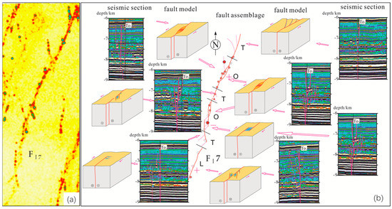
Figure 3.
(a) The maximum seismic wave crest image at the top of the Middle Ordovician carbonate of strike-slip fault FⅠ7 (the red line showing strike-slip fault zone and the green spot showing large fracture-cave reservoir); (b) segment model and seismic section interpretation of fault FⅠ7 (L: linear segment; T: tip segment; O: overlap segment; the blue block in the model shows falling block and the red block showing bulge block; To3: base of the Upper Ordovician).
The strike-slip fault has inherited multiple activities from the Middle Ordovician to Permian, but the late fault activities mainly occurred at the strata above the Middle Ordovician (Figure 2). Further, there are progressively weakened fault activities after Late Ordovician that resulted in intact preservation of the early fault segmentation. In addition, the distinct fault segmentation supporting that linkage process is the major growth mechanism for the small displacement but long strike-slip fault zone [31,34]. This is consistent with the isolated segments in small fault zones but through-going segments in the large fault zones such as faults FⅠ5, FⅠ10 and FⅠ17. In this context, multiple fault activities had little influence on the segmentation of the immature strike-slip fault zones in the Ordovician carbonate.
5. Fluid Distribution along the Strike-Slip Fault Zone
Statistically, the normal and light crude oils have low viscosity, low sulfur content and high wax content in the Ordovician carbonate reservoirs. In the study area, fluid samples from 130 wells show significantly variable properties along the strike-slip fault zones (Figure 4).
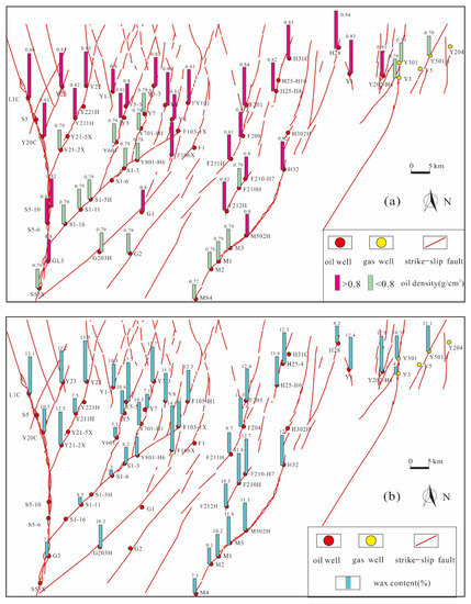
Figure 4.
(a) The oil density and (b) wax content in Fuman Oilfield.
The density of surface crude oil varies in the range 0.77–0.88 g/cm3 (20 °C), and oil colloid-asphaltene varied at 0.2–19.8%, with the oil characterized by a combination of normal oil and condensate gas (Figure 4a). Crude oil viscosity is 0.89–9.78 mPa•s (50 °C); freezing point is 30–10 °C; average sulfur is 0–0.77%; variable wax content is 0.2–19.8% (Figure 4b). The oil density, wax content and other physical properties show an increasing trend from south to north and from east to west in the study area. There are quite different properties along the strike of the fault zone. The oil with a low density, i.e., less than 0.8 g/cm3, and a high gas/oil ratio (GOR) is generally condensate oil. Along the strike-slip fault zone, the oil density and wax content change regularly from south to north. For example, from well M4 in the south to well H32 in the north of fault FⅠ17, the crude oil density increases from 0.77 g/cm3 to 0.82 g/cm3, and the wax content increases from 7.5% to 11.8%. The crude oil has low density, low viscosity, minimal sulfur and high wax content oil along a fault zone, but some wells have oil with high density, high sulfur, and low wax content. Further, there are some irregular variations showing a sudden decrease or increase trend of oil properties in some strike-slip fault zones. These suggest that there is a different fluid property between the fault segments along a strike-slip fault zone, which resulted in the complexity of oil accumulation and alteration.
The gas components include CH4 (46.7–84.6%), CO2 (0.1–9.6%) and N2 (0.67–24.7%). The average gas density is 0.67–0.96 g/L. H2S varies in a large range of 0–15,482 ppm. The samples display dryness coefficient at 0.48–0.98%, and most of them present dissolved gas in the oil production wells. The dry gas coexists with normal oil with a density of up to 0.85 g/cm3 along a fault zone (Figure 5a). The GOR (gas/oil ratio) varies in the range 46–3405 m3/m3, with most less than 600 m3/m3 with high oil density (Figure 5b). With the increase in drying coefficient, nitrogen content decreases while the gas/oil ratio increases. There is generally lower nitrogen content, higher GOR and drying coefficient in the eastern and southern areas. Most of the natural gas samples show dry gas in the eastern area. In addition, the gas parameters vary greatly in the Ordovician reservoirs to show the coexistence of dry and wet gas along a fault zone.
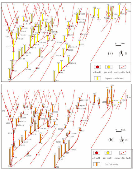
Figure 5.
(a) The dryness coefficient and (b) gas/oil ratio in Fuman Oilfield.
In Fuman Oilfield, at the ultra-deep (>7000 m) depression, most high oil/gas production wells occurred along strike-slip fault zones (Figure 4 and Figure 5) and penetrated large-scale fracture-cave reservoirs. This kind reservoir shows porosity of more than 10% and permeability of more than 5 mD, and many mud leakages and drilling breaks during the well drilling period. The distribution of the carbonate fracture-cave reservoirs is extremely heterogeneous along a fault zone [18,20,21] (Figure 6a). The fractured reservoirs are generally unconnected between the isolated or soft-linked fault segments in the immature fault zones. This is consistent with the fluid property (Figure 6c) and oil production (Figure 6d). However, most large fracture-cave reservoirs are connected between hard-linked fault segments. Additionally, there is same fluid property between the fault segments (Figure 6c). These suggest fault segment-related reservoir segmentation, as well as the oil accumulation along a strike-slip fault zone.
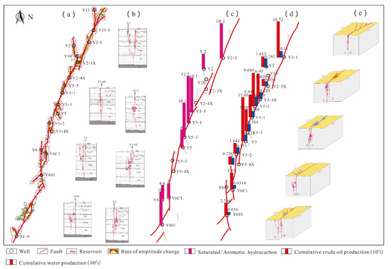
Figure 6.
(a) The reservoir segmentation by seismic attribute of amplitude change rate; (b) different well reservoir models by reservoir description; (c) saturation/aromatics ratio; (d) oil production and (e) oil pool models along the strike-slip fault FⅠ7 in Fuman Oilfield.
6. Discussions
6.1. Fault Segmentation on the Oil Reservoir Type
Generally, the long strike-slip fault zone has been thought to be a through-going fault zone (Figure 1) [18,30]. In this way, a fault zone or a large fault segment is assumed to be a large fault-controlled oil pool in Fuman Oilfield [18,19,25]. Alternatively, the oil accumulation has been assumed to be controlled by a large area of karst reservoirs connected by fracture network along a strike-slip fault zone [16,29].
On the compiled production data, the oil production of a well varies within a wide range of 50–100 t/d in Fuman Oilfield. In addition, the oil and water production showed different fluctuation between wells, and the oil decline curves changed rapidly among wells. There is also unstable water production and a varied water/oil ratio along the strike of a fault zone. The segmentation of the oil reservoirs is characterized by segment difference in oil/water contact and production, as well as the pressure change with the fault segment. These are consistent with the segmentation of the reservoir and fluid properties of crude oil and natural gas, drying coefficient of natural gas, and saturated/aromatic ratio of crude oil along a fault zone. These suggest that there are a series of fault segment-controlled oil pools along a strike-slip fault zone (Figure 6e), and an isolated fault segment is a small, isolated oil pool in a constant-volume reservoir in the immature fault zone. In this context, there is a series of small oil reservoirs along the strike-slip fault zones to form a large oilfield in the depression (Figure 7).
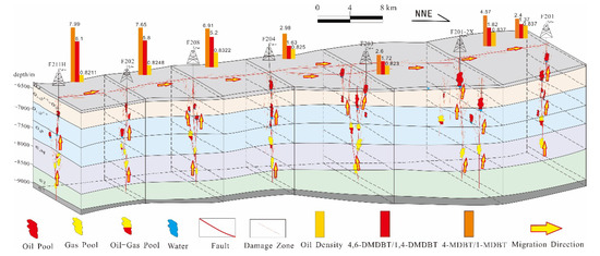
Figure 7.
The oil reservoir model along the fault FⅠ7 in Fuman Oilfield (the reservoir distribution from the seismic reservoir description [18]).
It is noted that some wells yielded high water production in a structural height, but others had high oil production in nearby low positions. This is inconsistent with the structural oil reservoir in the broad depression. The “sweet spot” in the fracture-cave reservoir is generally isolated with the fault segmentation, suggesting non-structural trap in the oilfield. There is generally low porosity and low permeability in the tight matrix reservoirs, but the porosity of the “sweet spot” in localized fracture-cave reservoirs is up to 10~50%, and the permeability is more than 5 mD. This can comprise isolated fracture-cave traps in the deep subsurface. Between the isolate fault segment, the host rocks lost almost all matrix porosity during the long process of diagenesis, which could lead to diagenetic barrier to show isolate traps among different fault segments [37]. In the hard-linked segments, there are complex triple pore-space composed of secondary dissolution pores and fractures, which could lead to complicated trap change during the long diagenetic history. Additionally, the weakly connected fracture-cave reservoirs could be connected during oil production. In this way, a well could have a sudden increase in oil production during the decreased production period. Hence, the strike-slip fault zones are preferred to be sealed in most fracture networks except for the fault reactivation time [29,37].
6.2. Fault Segmentation on the Oil Migration
Recent studies show that the source rocks of the Lower Cambrian in the north depression are well developed and overlapped with the strike-slip faults in Aman Transition Zone [18,33]. Through the connection of the strike-slip faults, multiple oil-bearing plays formed in the Lower and Upper Cambrian, Lower Ordovician Penglaiba Formation and Yingshan Formation, and Middle Ordovician Yijianfang Formation and Upper Ordovician Lianglitage Formation, which comprise a strike-slip fault-controlled petroleum system [18,27] (Figure 1 and Figure 8). The Yingshan Formation and Yijianfang Formation at the top of the Ordovician carbonate are the main oil-bearing strata in Fuman Oilfield [19,25].
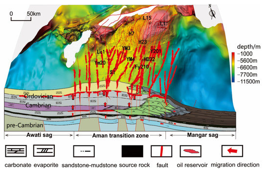
Figure 8.
The oil accumulation model in Fuman Oilfield.
All wells penetrated the Ordovician strata in the Aman Transition zone, suggesting an absence of Middle-Upper Ordovician source rock in the depression [18], whereas the shale source rock at the base of the Lower Cambrian has been penetrated by well L1 [33]. The shale rocks have high TOC, more than 2%, and the thickness increases progressively more than 100 m from the uplift to the central Aman depression [18,33]. In this context, Fuman Oilfield is located in the center of the source rock at the Lower Cambrian. However, the major source rock is buried deep, more than 2000 m from the base of the Lower Cambrian to the top of the Ordovician carbonate, particularly of a set of evaporites more than 200 m in thickness [18,29]. Subsequently, the fault network is the dominant pathway for oil vertical migration through tight strata [18,29,33]. During the quick subsidence of more than 1500 m Late Ordovician mudstone, the source rocks at the base Cambrian entered into the main oil generation and accumulation period [27]. A large amount of petroleum resource migrated vertically from the deep subsurface to form strike-slip fault-controlled oil reservoirs (Figure 8). Of course, there should be a lateral oil migration in the source rock for the oil transport to the fault zones. In the heterogeneous fault damage zone, the fracture network has complicated opening and sealing compartments that can result in multiple oil accumulation layers along the fractured reservoirs in the carbonate rocks.
A fault system has the advantages of short migration distance and high migration permeability, and preferential vertical and lateral migration passage [29]. Recent studies suggested that the strike-slip fracture network plays a significant role in hydrocarbon accumulation in the lower Paleozoic carbonate reservoirs in Fuman Oilfield [15,18,23]. However, little information could be used to show the lateral migration along the fault zones [11,12,13,14,15]. In this contribution, methyldibenzothiophene and trimethylnaphthalene are effective parameters to indicate hydrocarbon migration [14,35,36]. Geochemical migration fractionation effect parameter 4,6-/1,4-DMDBT (methyldibenzothiophene) indicates that oil has a trend of migration along NE-trending strike-slip faults (Figure 9), and localized high value points may be the result of high hydrocarbon charging intensity from the Lower Cambrian source rocks to the Ordovician carbonate reservoirs. There is much higher 4-/1-DMDBT in large strike-slip fault zones FⅠ5, FⅠ10 and FⅠ17, which suggests intense oil emplacement from the deep subsurface. Therefore, the maturity of crude oil is relatively high. In addition, some localized wells have higher 4-/1-DMDBT values revealing localized intense oil vertical charging, which are favorable vertical migration points.
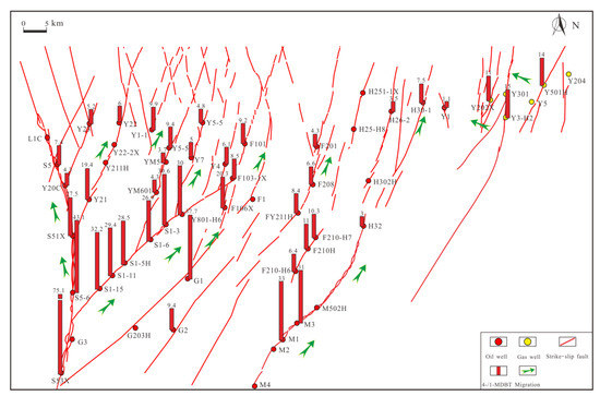
Figure 9.
The 4-/1-MDBT values showing the petroleum migration trend along the strike-slip fault zones in Fuman Oilfield.
On the other hand, the 4-/1-MDBT values show a decreased trend from south to north along the fault strike (Figure 9). The decreased trend of 4-/1-DMDBT values revealed a lateral oil migration direction from south to north along a fault zone. This is consistent with the regional fluid potential from the southern depression to the northern uplift [16,29], and the varied trend of the oil property [4,5]. These trends of fluid properties and geochemical data are constrained along the fault zone, indicating a lateral oil migration direction along the fault zone. Further, the trends show that the oil migration at the Ordovician is closely related with the segmentation along the strike-slip fault strike. Taking FY2 fault zone as an example (Figure 10), the crude oil maturity parameters 4-/1-MDBT and 4,6-/1,4-MDBT show two distinct decreased segments from well F211H to F203 and from well F201-2x to F201, indicating two isolated segments for oil migration along the fault strike. Furthermore, most fault zones present variable fluid property and geochemical values along the fault segments (Figure 4, Figure 5 and Figure 9). These are in agreement with the segmentation of fault assemblage, reservoir and fluid property (Figure 4 and Figure 5). In addition, there are gradually varied fluid property and 4-/1-DMDBT values in the northeastern YK area. These revealed a gas lateral migration from east to west across the fault zones, rather than along a fault zone. This is possibly related to the intense Cenozoic gas cut in the eastern area [16,29]. It should be noted that the hydrocarbon enrichment is constrained by fault segmentation in oil migration and by forming isolated reservoir compartments by segmented heterogeneous reservoirs. This suggests that the fractured reservoirs in most wells are not through-going in different segments. During the period of stagnation of fault activity, fractures were filled and cemented completely [37], and the oil was constrained in localized connected fracture-reservoirs. In addition, the oilfield in a broad depression constrained the large-scale lateral oil/gas migration. This was also an important factor for the preservation of a large amount of oil reserves that formed in the Late Ordovician in the stable depression [27].
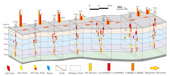
Figure 10.
The petroleum migration trend along the strike-slip fault in FY2 area (DMDBT: dimethyldibenzothiophene).
Considering the fluid and reservoir data together, the lateral migration of the Ordovician hydrocarbon in this study area is fairly controlled by the strike-slip fault segmentation. During the fault reactivation, hydrocarbon was transported vertically by the strike-slip fracture network from the deep Lower Cambrian to the Ordovician carbonates and by partial lateral migration to the NE-direction high position along the fault damage zone. The strike-slip fracture network was well developed to form a pathway for vertical migration, but it was not well connected for lateral oil/gas migration in the flat depression. In this context, there is more oil/gas resource accumulation and enrichment in the source rock-developed depression (Figure 8), and there is greater exploitation potential along the strike-slip fault zone in the deep depression than in the paleo-uplift, which has undergone multi-stage petroleum adjustment [16,29].
7. Conclusions
The strike-slip fault plays a significant role in hydrocarbon migration and accumulation in the lower Paleozoic carbonate reservoirs in Fuman Oilfield, which is different from the conventional porous carbonate reservoirs along through-going fault zones.
(1) The strike-slip fault zone has distinct fault segmentation in Fuman Oilfield and, in turn, subsequent variable fault architecture and non-connected fracture network other than a through-going fault zone.
(2) There are isolated fractured reservoirs and fluid variation along the strike-slip fault segments, and the large oilfield is composed of a series of unconnected small oil pools by the fault segmentation in Fuman Oilfield.
(3) There is a variable and segmented petroleum lateral migration along the strike-slip fault segment rather than a through-going fault zone in Fuman Oilfield.
(4) Strike-slip fault segmentation has variable effects on petroleum migration and accumulation along the strike-slip zone.
Author Contributions
Conceptualization, Y.Z. (Yongfeng Zhu) and G.W.; methodology, X.Z. and S.Y.; software, Z.X. and P.K.; investigation, Y.Z. (Yintao Zhang) and G.W.; data curation, Y.Z. (Yintao Zhang) and X.Z.; resource, T.L. and P.K.; writing, G.W. and X.Z.; visualization, Z.X. and T.L.; supervision, Y.Z. (Yongfeng Zhu) and Y.Z. (Yintao Zhang); funding acquisition, Y.Z. (Yongfeng Zhu) and Y.Z. (Yintao Zhang). All authors have read and agreed to the published version of the manuscript.
Funding
Prospective Basic Research Project of CNPC (2021DJ1502) and the National Natural Science Foundation of China (Grant No. 9195520441472103).
Institutional Review Board Statement
Not applicable.
Informed Consent Statement
Not applicable.
Data Availability Statement
Not applicable.
Acknowledgments
The authors thank the editor and reviewers for their comments regarding manuscript improvement. We also thank Hao Tang, Xinwei Chen, Ziye Lu and Yifeng Xu for their helps in data and visualization.
Conflicts of Interest
The authors declare no conflict of interest.
References
- Sun, L.D.; Zou, C.N.; Zhu, R.K.; Zhang, Y.H.; Zhang, S.C.; Zhang, B.M.; Zhu, G.Y.; Gao, Z.Y. Formation, distribution and potential of deep hydrocarbon resources in China. Pet. Explor. Dev. 2013, 40, 687–695. [Google Scholar] [CrossRef]
- Pang, X.Q.; Jia, C.Z.; Wang, W.Y. Petroleum geology features and research developments of hydrocarbon accumulation in deep petroliferous basins. Pet. Sci. 2015, 12, 1–53. [Google Scholar] [CrossRef] [Green Version]
- Yang, H.J.; Wu, G.H.; Scarselli, N.; Sun, C.H.; Qing, H.R.; Han, J.F.; Zhang, G.W. Characterization of reservoirs, fluids, and productions from the Ordovician carbonate condensate field in the Tarim Basin, northwestern China. AAPG Bull. 2020, 104, 1567–1592. [Google Scholar] [CrossRef]
- Ou, C.H.; Li, C.C.; Huang, S.Y.; Lu, W.T.; Sheng, J.J.; Xiong, H.L. Three-dimensional discrete network modeling of structural fractures based on the geometric restoration of structure surface: Methodology and its application. J. Pet. Sci. Engin. 2018, 161, 417–426. [Google Scholar] [CrossRef]
- Benmadi, M.; Sayantan, G.; Roger, S.; Kurt, M.; Mashhad, F. Practical aspects of upscaling geocellular geological models for reservoir fluid flow simulations: A case study in integrating geology, geophysics, and petroleum engineering multiscale data from the Hunton Group. Energies 2020, 13, 1604. [Google Scholar]
- Rashid, F.; Hussein, D.; Lawrence, J.A.; Ahmed, Z. Fluid flow and permeability analysis of tight gas carbonate reservoir rocks using fractures and dynamic data. J. Nat. Gas Sci. Engin. 2021, 90, 103894. [Google Scholar] [CrossRef]
- Caine, J.S.; Evans, J.P.; Forster, C.B. Fault zone architecture and permeability structure. Geology 1996, 24, 1025–1028. [Google Scholar] [CrossRef]
- Aydin, A. Fractures, faults and hydrocarbon entrapment, migration and flow. Mar. Pet. Geol. 2000, 17, 797–814. [Google Scholar] [CrossRef]
- Jeanne, P.; Guglielmi, Y.; Lamarche, J.; Cappa, F.; Marié, L. Architectural characteristics and petrophysical properties evolution of a strike-slip fault zone in a fractured porous carbonate reservoir. J. Struc. Geol. 2012, 44, 93–109. [Google Scholar] [CrossRef]
- Pei, Y.; Paton, D.A.; Knipe, R.J.; Wu, K.Y. A review of fault sealing behaviour and its evaluation in siliciclastic rocks. Earth-Sci. Rev. 2015, 150, 121–138. [Google Scholar] [CrossRef]
- Zhang, L.; Liao, Z.H.; Long, K.; Carpenter, B.M.; Zou, H.Y.; Hao, F. Fundamental constraints of lithologically-controlled fault networks on gas migration and accumulation for fractured carbonates in the western Sichuan Basin, China. J. Pet. Sci. Engin. 2022, 208, 109502. [Google Scholar] [CrossRef]
- Jin, Z.J.; Cao, J.; Hu, W.X.; Zhang, Y.J.; Yao, S.P.; Wang, X.L.; Zhang, Y.Q.; Tang, Y.; Shi, X.P. Episodic petroleum fluid migration in fault zones of the northwestern Junggar Basin (nortwest China): Evidence from hydrocarbon-bearing zoned calcite cement. AAPG Bull. 2008, 92, 1225–1243. [Google Scholar] [CrossRef]
- Xu, S.; Hao, F.; Xu, C.G.; Zou, H.Y.; Quan, Y.B. Oil migration through preferential petroleum migration pathway (PPMP) and polycyclic faults: A case study from the Shijiutuo Uplift, Bohai Bay basin, China. Mar. Pet. Geol. 2016, 73, 539–553. [Google Scholar] [CrossRef]
- Wang, Y.Y.; Chen, J.F.; Pang, X.Q.; Wang, G.; Hu, T.; Zhang, B.S.; Huo, Z.P.; Chen, H.Y. Hydrocarbon migration along fault intersection zone—A case study on Ordovician carbonate reservoirs in Tazhong area, Tarim Basin, NW China. Geol. J. 2017, 52, 832–850. [Google Scholar] [CrossRef]
- Mahtab, M.; Rudy, S.; Fabrizio, B.; Hamdy, E.D.; Fabrizio, S.; Conxita, T. Fault-controlled dolomitization in the Montagna dei Fiori Anticline (Central Apennines, Italy): Record of a dominantly pre-orogenic fluid migration. Solid Earth 2019, 10, 1355–1383. [Google Scholar]
- Du, J. Oil and Gas Exploration of Cambrian-Ordovician Carbonate in Tarim Basin; Petroleum Industry Press: Beijing, China, 2010. (In Chinese) [Google Scholar]
- Tian, J.; Wang, Q.H.; Yang, H.J.; Li, Y. Petroleum Exploration History and Enlightenment in Tarim Basin. Xinjiang Pet. Geol. 2021, 42, 272–282, (In Chinese with English abstract). [Google Scholar]
- Wang, Q.H.; Yang, H.J.; Wang, R.J.; Li, S.Y.; Deng, X.L. Discovery and exploration technology of fault-controlled large oil and gas fields of ultra-deep formation in strike slip fault zone in Tarim Basin. China Pet. Explor. 2021, 26, 58–71, (In Chinese with English abstract). [Google Scholar]
- Yang, X.W.; Wang, R.J.; Deng, X.L.; Li, S.Y.; Zhang, H.; Yao, C. Theoretical exploration and practice of water injection gravity flooding oil in ultra-deep fault-controlled fractured-cavity carbonate reservoirs. Pet. Explor. Dev. 2022, 49, 133–143. [Google Scholar] [CrossRef]
- Li, Z.; Yang, Z.; Li, H.; Liu, J.; Gong, W.; Ma, X.; Yang, L.; Huang, C. Three-dimensional seismic exploration method for ultra-deep fault-related dissolution reservoirs in the Shunbei desert area. Geophys. Prospec. Pet. 2020, 59, 283–294, (In Chinese with English abstract). [Google Scholar]
- Li, X.; Li, J.; Li, L.; Wan, Z.; Liu, Y.; Ma, P.; Zhang, M. Seismic wave field anomaly identification of ultra-deep heterogeneous fractured-vuggy reservoirs: A case study in Tarim Basin, China. Appl. Sci. 2021, 11, 11802. [Google Scholar] [CrossRef]
- Wu, G.H.; Zhao, K.Z.; Qu, H.Z.; Nicola, S.; Zhang, Y.T.; Han, J.F.; Xu, Y.F. Permeability distribution and scaling in multi-stages carbonate damage zones: Insight from strike-slip fault zones in the Tarim Basin, NW China. Mar. Pet. Geol. 2020, 114, 104208. [Google Scholar] [CrossRef]
- Ding, Z.; Wang, R.; Chen, F.; Yang, J.; Zhu, Z.; Yang, Z.; Sun, X.; Xian, B.; Li, E.; Shi, T.; et al. Origin, hydrocarbon accumulation and oil-gas enrichment of fault-karst carbonate reservoirs: A case study of Ordovician carbonate reservoirs in South Tahe area of Halahatang oilfield, Tarim Basin. Pet. Explor. Dev. 2020, 47, 306–317. [Google Scholar] [CrossRef]
- Yun, L. Controlling effect of NE strike-slip fault system on reservoir development and hydrocarbon accumulation in the eastern Shunbei area and its geological significance, Tarim Basin. China Pet. Explor. 2021, 26, 41–52, (In Chinese with English abstract). [Google Scholar]
- He, X.; Wang, R.; Yang, J.; Li, S.; Yan, C.; Wu, G. Optimization of Oil Productivity from the Ultra−Depth Strike−Slip Fault−Controlled Carbonate Reservoirs in Northwestern China. Energies 2022, 15, 3472. [Google Scholar] [CrossRef]
- Lu, Z.Y.; Li, Y.T.; Ye, N.; Zhang, S.; Huang, B. Fluid inclusions record hydrocarbon charge history in the Shunbei area, Tarim Basin, NW China. Geofluids 2020, 8847247. [Google Scholar] [CrossRef]
- Yang, S.; Wu, G.H.; Zhu, Y.F.; Zhang, Y.T.; Zhao, X.X.; Lu, Z.Y.; Zhang, B.S. Key oil accumulation periods of ultra-deep fault-controlled oil reservoir in northern Tarim Basin, NW China. Pet. Explor. Dev. 2022, 49, 249–261. [Google Scholar]
- Jia, C. Tectonic Characteristics and Petroleum, Tarim Basin, China; Petroleum Industry Press: Beijing, China, 1997. (In Chinese) [Google Scholar]
- Wu, G.; Pang, X.; Li, Q.; Yang, H. The Structural Characteristics of Carbonate Rocks and Their Effects on Hydrocarbon Exploration in Craton Basin: A Case Study of the Tarim Basin; Science Press: Beijing, China, 2016. (In Chinese) [Google Scholar]
- Yang, H.J.; Wu, G.H.; Han, J.F.; Su, Z. Structural analysis of strike slip faults in the Tarim intracratonic Basin. Chin. J. Geol. 2020, 55, 1–16, (In Chinese with English abstract). [Google Scholar]
- Wu, G.H.; Ma, B.S.; Han, J.; Guan, B.Z.; Chen, X.; Yang, P.; Xie, Z. Origin and growth mechanisms of strike-slip faults in the central Tarim cratonic basin, NW China. Pet. Explor. Dev. 2021, 48, 510–520. [Google Scholar] [CrossRef]
- Zhu, G.Y.; Chen, F.R.; Wang, M.; Zhang, Z.Y.; Ren, R.; Wu, L. Discovery of the lower Cambrian high-quality source rocks and deep oil and gas exploration potential in the Tarim Basin, China. AAPG Bull. 2018, 102, 2123–2151. [Google Scholar] [CrossRef]
- Yang, H.J.; Chen, Y.Q.; Tian, J.; Du, J.H.; Zhu, Y.F.; Li, H.H.; Pan, W.Q.; Yang., P.F.; Li, Y.; An, H.T. Great discovery and its significance of ultra-deep oil and gas exploration in well Luntan-1 of the Tarim Basin. China Pet. Explor. 2020, 25, 62–72, (In Chinese with English abstract). [Google Scholar]
- Wu, G.; Kim, Y.S.; Su, Z.; Yang, P.; Ma, D.; Zheng, D. Segment interaction and linkage evolution inconjugate strike-slip fault system from the Tarim Basin, NW China. Mar. Pet. Geol. 2020, 112, 104054. [Google Scholar] [CrossRef]
- Wang, T.; He, F.; Li, M.; Hou, Y.; Guo, S. Alkyldibenzothiophenes: Molecular tracers for filling pathway in oil reservoirs. Chin. Sci. Bull. 2004, 49, 2399–2404, (In Chinese with English abstract). [Google Scholar]
- Fang, R.H.; Wang, T.G.; Li, M.J.; Xiao, Z.Y.; Zhang, B.S.; Huang, S.Y.; Shi, S.B.; Wang, D.W.; Deng, W.L. Dibenzothiophenes and benzo [b] naphthothiophenes: Molecular markers for tracing oil filling pathways in the carbonate reservoir of the Tarim Basin, NW China. Org. Geochem. 2016, 91, 68–80. [Google Scholar] [CrossRef]
- Wu, G.; Xie, E.; Zhang, Y.; Qing, H.; Luo, X.; Sun, C. Structural diagenesis in carbonate rocks as identified in fault damage zones in the Northern Tarim Basin, NW China. Minerals 2019, 9, 360. [Google Scholar] [CrossRef] [Green Version]
Publisher’s Note: MDPI stays neutral with regard to jurisdictional claims in published maps and institutional affiliations. |
© 2022 by the authors. Licensee MDPI, Basel, Switzerland. This article is an open access article distributed under the terms and conditions of the Creative Commons Attribution (CC BY) license (https://creativecommons.org/licenses/by/4.0/).