Abstract
The sedimentary characteristics of the Neogene in the eastern Liaodong area are poorly studied, which restricts the oil and gas exploration in this area. Based on the current seismic, logging, drilling, and core data, we have studied the sequence stratigraphy and sedimentary characteristics of the Neogene in the eastern Liaodong area. Ultimately, we identified the controlling factors of sedimentation and established the depositional model. In this study, six sequence boundaries of the Neogene were identified and can be divided into five third-order sequences. The sedimentary evolution can be divided into four stages: braided river delta, meandering river delta with a low sand-stratum ratio, meandering river delta with a high sand-stratum ratio, and meandering river delta. Both the palaeotectonic movements and paleoclimate changes of the Neogene influence the periodical fluctuation of the lake level and then control the vertical evolution of the sedimentary types. The paleogeomorphology controls the macroscopic distribution of the sedimentary facies zone, the paleo-valleys that are associated with the strike-slip faults control the channel strike, and the fault slopes at the edge of the lacustrine basins control the sand redistribution of the delta front.
1. Introduction
The essence of sequence stratigraphy is the isochronicity of its interfaces and the cyclicity of the inner layers of the sequence [1,2]. The strata of continental rift basins also have obvious cyclicity and isochronous stratigraphic interfaces [3,4]. Therefore, the theory and method of sequence stratigraphy have been widely used in lacustrine basins. The formation of a marine clastic sequence is mainly controlled by the global sea level [5,6,7,8], while more attention will be paid to the tectonic activity, climate change and other factors of basin-filling evolution in continental rift basins [9,10]. In recent years, Chinese scholars have made important progress in the sequence-stratigraphy evaluation of lacustrine basins [11,12,13,14,15]. The study of sequence stratigraphy can help to establish an isochronous-sequence stratigraphic framework, and the study of sedimentary characteristics and evolution law under its control is conducive to defining the distribution characteristics of sand bodies [16,17,18]. All these studies can guide the detailed exploration of complex lacustrine basins.
Since the 1990s, the discovered reserves of the Neogene in the Bohai Sea have accounted for 65% of the total reserves of the whole Bohai oilfield, and the reserves of the Neogene in the Bozhong sub-basin have accounted for more than 95% of the total proved reserves [19,20,21,22], revealing the broad exploration prospects of the Neogene in the Bohai Sea area [23,24,25,26,27,28,29,30]. The oil and gas exploration in the eastern Liaodong area started in 2003, and the structural reservoirs of the Neogene were the main targets at that time. In 2015, well SS701 achieved a high yield in the structural-lithologic trap of the Guantao Formation, which indicates the exploration potential of structural-lithologic reservoirs and lithologic reservoirs. Due to the limitation of data quality, the study of sequence stratigraphy and sedimentary characteristics in this area has been lacking, which restricts further exploration.
On the basis of previous studies, we studied the sequence stratigraphy and sedimentary characteristics of the Neogene in the study area, making full use of the 3D seismic data and the latest drilling and logging data. The main objectives of this study are: (1) to clarify the relationship between the sequence stratigraphy and the sedimentary facies; (2) to analyse the sedimentary evolution laws and their controlled factors under the sequence stratigraphic framework; (3) to establish the sedimentary development mode. The findings of the present study provide references for the study sequence of the stratigraphy and sedimentary characteristics of the Neogene in other areas, and it fills in the blank for sedimentary-system research in the eastern Liaodong area, which can provide guidance for oil and gas exploration.
2. Geological Setting
The eastern Liaodong area is located at the junction of Bodong Sag and Jiaoliao Massif [31,32,33], which is a positive structural belt at the basin margin (Figure 1a,b). At the beginning of the Cenozoic—affected by the collision between the Indian plate and the Eurasian plate [34]—the whole area underwent three developmental processes: fault depression, fault depression transition, and depression [35], with six stages of tectonic movements, which developed as a result [27,36]. Two tectonic movements were developed in the Neogene period, including the post-rift thermal sag stage and the Neotectonic movement stage. Four groups of fault systems were developed for the Neogene in the study area: NNE, NWW, NE and nearly EW. Among them, the NNE-trending faults are the extension of the Bodong No. 3 fault zone, which is the east branch of the Tan-Lu fault zone, while the NWW-trending faults belong to the Zhangjiakou-Penglai No. 3 strike-slip fault zone and its two derived strike-slip fault zones. The NE-trending and nearly EW-trending faults are the products of Neotectonic movement [37,38]. The Zhangjiakou-Penglai No. 3 strike-slip fault zone has the largest coverage among the NWW-trending faults, extending to Bodong Sag to the west, with its two derived strike-slip fault zones intersecting the Bodong No. 3 fault to the west (Figure 1c and Figure 2).
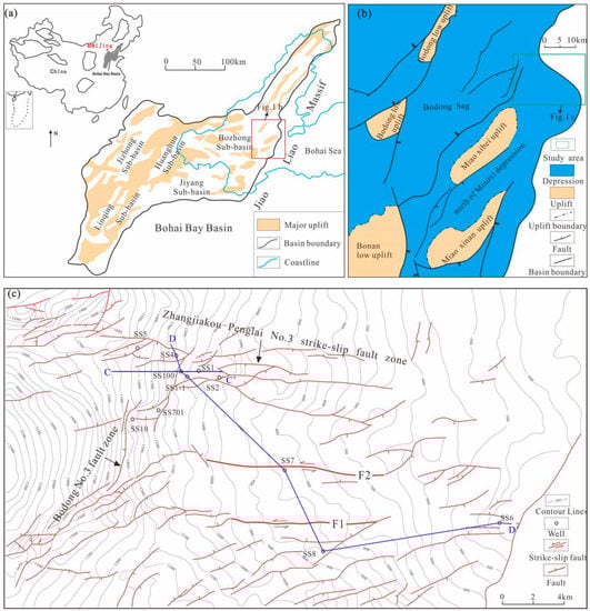
Figure 1.
(a) Sub-basins of the Bohai Bay Basin. (b) Location map of study area. (c) Bottom structure map of Guantao Formation in the study area.
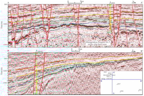
Figure 2.
Seismic section AA′ and BB′ across the eastern Liaodong area, showing fault distribution, stratigraphic units and sequences.
The study area is based on Archean metamorphic rocks, developing the strata of the Middle-Upper Proterozoic, Shahejie Formation and Dongying Formation of the Paleogene, Guantao Formation and Minghuazhen Formation of the Neogene and Quaternary [31,32]. The Guantao Formation can be further divided into upper and lower members, both of which have similar lithological characteristics, except for a set of conglomerate and gravelly sandstone deposits that developed at the bottom of the lower Guantao Formation (Figure 3). The rest of the sections are interbedded with fine sandstone, siltstone and mudstone, with different thicknesses. The Minghuazhen Formation is characterized by an extremely thick sandstone interbedded with thin mudstone. The Guantao Formation overlaps the uplift area from west to east, while Minghuazhen Formation onlaps it (Figure 2), forming a large-scale stratigraphic overlap and an overlapping structural belt with a series of structural, lithologic and stratigraphic traps.
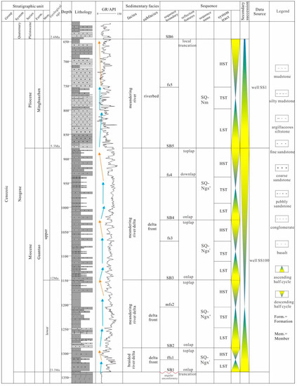
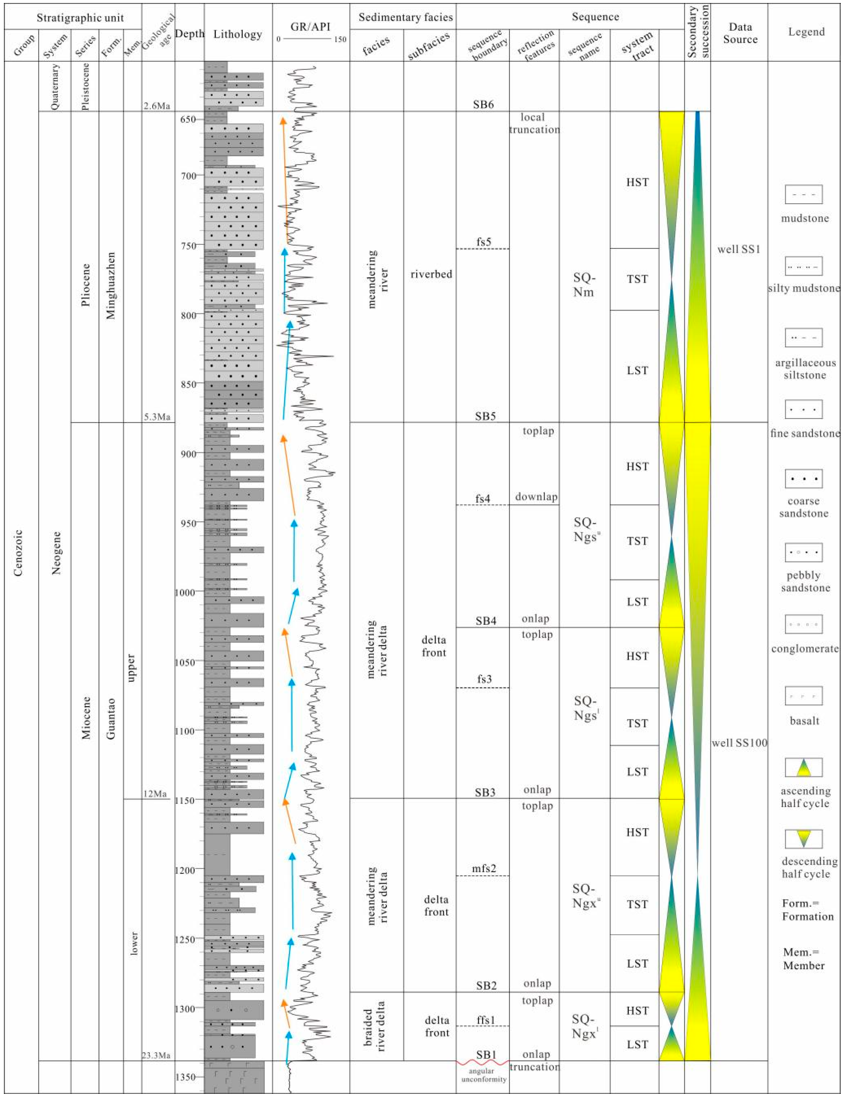
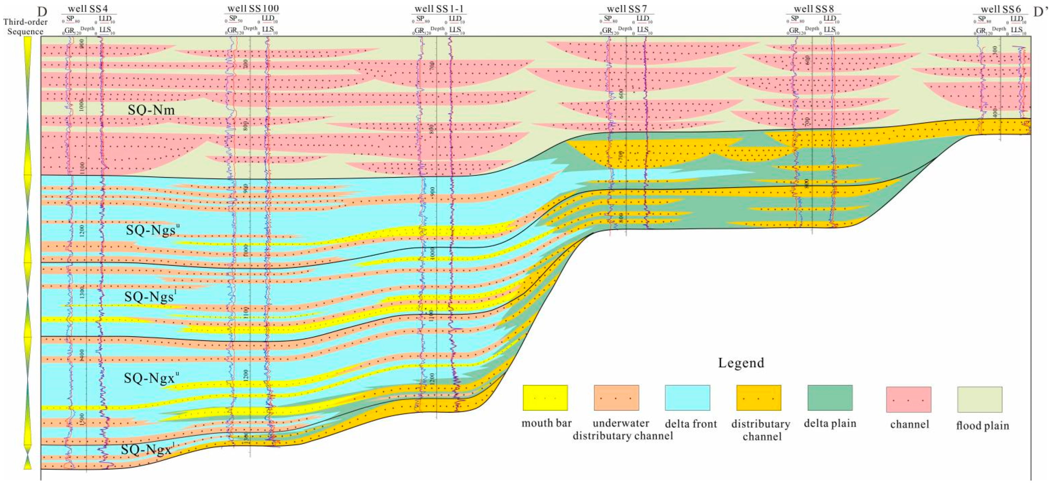
Figure 3.
Sequence stratigraphic division of the Neogene in the eastern Liaodong area.
3. Materials and Methods
3.1. Materials
The data employed in this research were provided by Shengli Oilfield Company, Sinopec. Currently, there are 11 wells drilled in the study area, with GR log, SP log, RT log, AC log, LLD and LLS log, and core data (cumulative core length up to 45 m from 2 wells). In addition, 400 km2 of 3D seismic data are added to the key study areas with a 12.5 m × 25 m grid, as well as 11 cross-well synthetic seismograms to the well-tie seismic-based sequence analysis. The main frequency bandwidth of the seismic data ranges from 10 to 65 Hz, with a dominant frequency of 35 Hz.
3.2. Methods
In the present study, the research methodology was based on classical sequence-stratigraphy and sedimentary theory. The recognition of the sequence boundary is the basis for establishing a sequence stratigraphic framework [39,40,41]. To achieve this goal, we made full use of the stratigraphic superposition characteristics, lithology and logging characteristics, based on data from 11 wells. An integrated interpretation of the 3D seismic data, which covers the study area, provides a foundation for the establishment of a seismic-sequence stratigraphic framework. Using the calibration results of a synthetic seismogram, the distribution characteristics of the sequence interface and the contact relationship between the upper and lower interfaces can be traced on 3D seismic data. The core is described from the aspects of lithology, grain size, sorting and sedimentary structure, so as to determine the sedimentary facies characteristics. The spatial distribution characteristics of the sedimentary system are carried out according to integrated analysis of the paleogeomorphology, logging data, and seismic reflection characteristics. In addition, the study of the sedimentary-controlled factors is mainly combined with the analyses of palaeoclimate and palaeotectonic movements.
The paleogeomorphology was restored by the technique of flattening. The quantitative analysis of the topographic slope in the Neogene was completed based on the seismic profiles, and the steps were as follows: (1) select a seismic profile in the direction of the source through a well, and flatten the top horizon of the Neogene; (2) the trend line of the interpretation of the bottom horizon of the Guantao Formation is extended and intersects at a certain point with the top levelling line in Step 1. The horizontal distance between the actual drilling point and the intersection point is obtained, which can be defined as L (length); (3) the thickness of the Neogene formation at the well’s point was calculated using drilling data, which can be defined as H (height); (4) the topographic slope can be approximately expressed as follows: θ = arc tan (H/L).
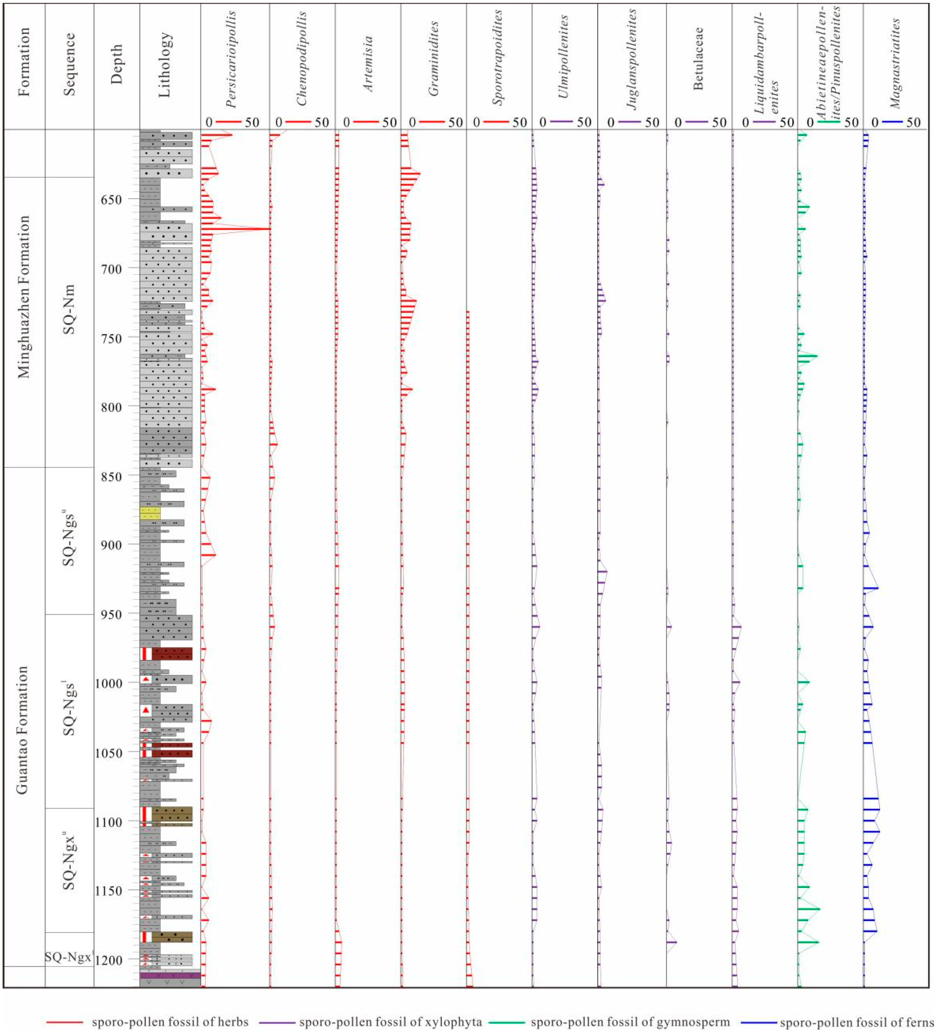
The paleoclimate was analyzed by sporo-pollen fossils of well SS1. One hundred ninety packages of cuttings at 356 m–1696 m of this well were analyzed. The appraisal institution is the Laboratory of Stratigraphy and Paleontology at the Research Institute of Exploration and Development, Shengli Oilfield Company, Sinopec. The detection equipment was a binocular biological microscope, and the appraisal results were based on the national classification standards SY/T5915-2000.
4. Results
4.1. Sequence Stratigraphic Framework
There are many different views on the division of the sequence stratigraphic framework of the Neogene in the Bohai Sea area. Some researchers hold the viewpoint that the Neogene and Quaternary represent the filling part of the depression stage; thus, it can be regarded as a complete second-order sequence as a whole [42], while other scholars think that the Neogene itself can be a second-order sequence [43]. In our view, the Miocene Guantao Formation is the main stage of depression in terms of the tectonic movement stages, which generally shows a cycle of water transgression to a water regression. The Neotectonic movement, in the early stage of the Pliocene Minghuazhen Formation, had a severe influence on the Bozhong sub-basin [44,45]. Therefore, in this paper, we regard the Neogene Guantao Formation as a whole second-order sequence, and the Minghuazhen Formation can be included in the next second-order sequence.
4.1.1. Identification of Sequence Boundaries
Finally, six sequence boundaries were identified, which were SB1–SB6, among which SB1 and SB5 are second-order sequence boundaries, and the rest are third-order sequence boundaries.
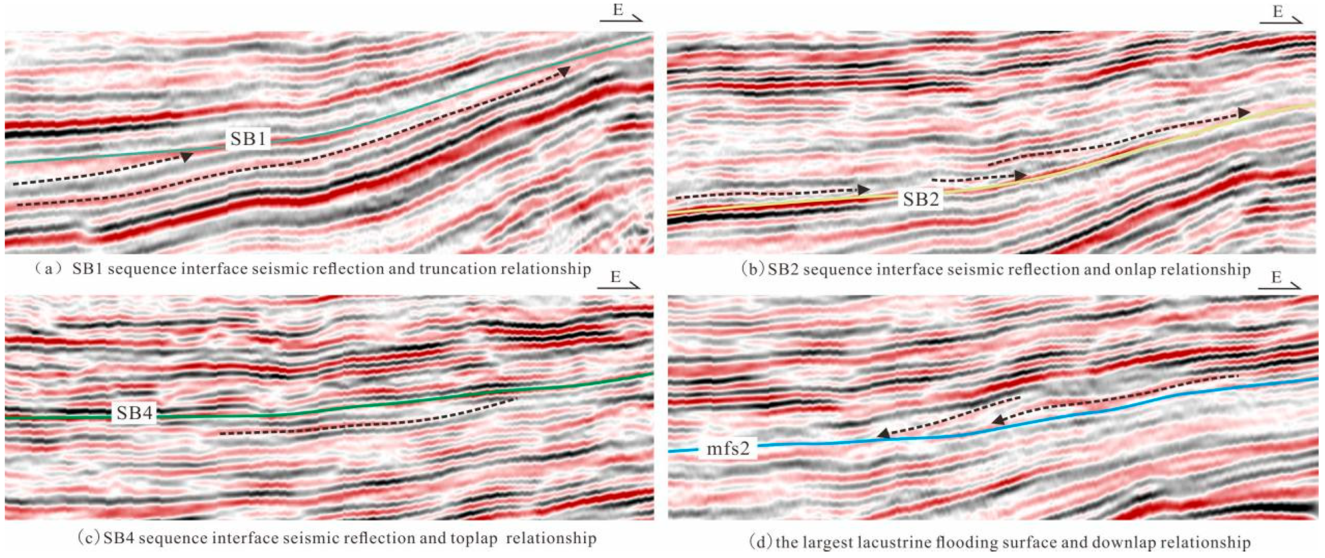
The second-order sequence boundaries are often related to the regional tectonic movements [46,47,48]. SB1 is a regional angular unconformity, formed by the Dongying movement in the Bohai Bay Basin, which is also a boundary between the Paleogene and Neogene. It is obvious to see the onlap reflection above the boundary and the termination type of truncated seismic reflection below the boundary (Figure 4a). The difference between the lithology and log characteristics is great across the unconformity surface. Above the boundary, glutenite deposits are developed; thus, the gamma-ray (GR) log curve is micro-toothed, box-shaped and funnel-shaped, while below the boundary, the volcanic rocks of the Dongying Formation are generally developed, with the GR log curve being low-amplitude straight-toothed (Figure 3). SB5 is the boundary between the Guantao Formation and Minghuazhen Formation, formed by the Neotectonic movement. There is no obvious sedimentary discontinuity, and only the local truncation reflection characteristics can be seen. Above the boundary, the seismic reflection continuity at the bottom of the Minghuazhen Formation is poor, and the amplitude changes greatly, while the seismic reflection continuity at the top of the Guantao Formation below the boundary is good and the amplitude is strong (Figure 2). SB5 is also a lithologic abrupt-change surface, with a large set of gray gravel sandstone and sandstone deposits above the boundary, and the GR shows a low value. Below the boundary, fine sandstone and mudstone, with fine lithologic grain size, are interbedded, and the content of sandstone gradually increases upward, with the GR at a high value (Figure 3).
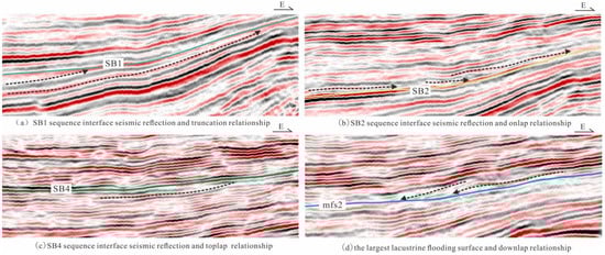
Figure 4.
Typical seismic reflection and stratigraphic contact relationship of sequence boundaries along EW direction of the Neogene in the eastern Liaodong area.
The third-order sequence boundaries (SB2–SB4) show the characteristics of a medium-strong amplitude and medium-strong continuous reflection on the seismic profile (Figure 2). The onlap reflection can be seen above each sequence boundary (Figure 4b), and the termination type of toplap reflection below the boundary is common (Figure 4c). In contrast, the seismic reflection of SB6 is a medium-weak horizontal reflection, with a medium continuity and local truncation (Figure 2). Across these third-order sequence boundaries, there are also some differences in the stratigraphic patterns and lithology characteristics between the upper and lower strata. The lithology that overlies and underlies the SB2, SB3 and SB4 boundaries is not much different, which is characterized by the interbedded sandstone and mudstone, however, the stratigraphic patterns obviously change. The sandstone content increases gradually below the boundary, showing a progradation pattern, while the sandstone content decreases gradually above the boundary, showing a retrogradation pattern, which makes the sequence boundaries at the conversion surface between progradation and retrogradation. There is a large set of sandstone deposits above the SB6, and a set of gray-green or gray mudstone deposits with a thickness of about 20–30 m below the SB6, reflecting a flooding event at the end of the Minghuazhen Formation (Figure 3).
4.1.2. Sequence Stratigraphic Framework Characteristics
Based on the identification of the sequence boundaries, the Neogene strata in the eastern Liaodong area can be divided into five third-order sequences, corresponding to the lower part of the lower member of the Guantao Formation (SQ-Ngxl), the upper part of the lower member of the Guantao Formation (SQ-Ngxu), the lower part of the upper member of the Guantao Formation (SQ-Ngsl), the upper part of the upper member of the Guantao Formation (SQ-Ngsu) and Minghuazhen Formation (SQ-Nm). On the whole, the sedimentary distribution scale of the Neogene strata in eastern Liaodong gradually becomes larger from the SQ-Ngxl to SQ-Nm, showing the feature as thicker in the west and thinner in the east, and the overall change in the stratum thickness is relatively stable. The SQ-Ngxl strata are limited in distribution—only developed in the west of wells SS701–SS10—while the sedimentary range of the SQ-Ngxu is enlarged to the west of well SS8 and with some local exposure near well SS7. The SQ-Ngsl has a distribution in the west of well SS8, with the SQ-Ngsu and SQ-Nm onlaps.
Through analyzing the logging curves and logging lithology data, five lacustrine flooding surfaces can be identified, which correspond to five lake-expanding events of the Neogene in the eastern Liaodong area. The SQ-Ngxl consists of a low-stand system tract (LST) and a high-stand system tract (HST), while the other third-order sequences all include an LST, a transgressive system tract (TST) and a HST (Figure 3). The stacking pattern of the lacustrine flooding surface strata has changed from retrogradation or aggradation to a progradation pattern, and the sandstone content above the interface has gradually increased. Among them, the seismic reflection of mfs2, the maximum lacustrine flooding surface, is obvious, showing a medium-strong amplitude, good continuity and easy tracking. Furthermore, an obvious downlap reflection can be seen above the interface (Figure 3 and Figure 4d).
4.2. Characteristics of Paleoclimate
Sporo-pollen fossils are the direct evidence of a paleoclimate change, and the longitudinal variation in the sporo-pollen assemblage reflects the changes in the paleoclimate and sedimentary environments [49]. Based on the analysis of the sporo-pollen fossils, it was found that the sporo-pollen fossils in the eastern Liaodong area of the Neogene could be divided into four assemblages from the bottom to the top. The sporo-pollen assemblage of the SQ-Ngxl and SQ-Ngxu was dominated by Magnastriatites-Abietineaepollenites/Pinuspollenites. Magnastriatites belong to the fern family, and the Abietineaepollenites/Pinuspollenites of conifers reflect the existence of warm evergreen, indicating that the paleoclimate was warm and wet during the deposition period. The sporo-pollen assemblage of the SQ-Ngsl was dominated by Liquidambarpollenites-Magnastriatites-Ulmipollenites. The content of Liquidambarpollenites increased significantly, which indicates a humid subtropical paleoclimate. The sporo-pollen assemblage of the SQ-Ngsu was dominated by Juglanspollenites-Magnastriatites-Ulmipollenites, and the Magnastriatites decreased significantly, which reflects the subtropical paleoclimate. Juglanspollenites and Ulmipollenites belong to the temperate plant type, indicating that the paleoclimate began to turn drier and cooler during this period. The sporo-pollen assemblage of the SQ-Nm was dominated by Persicarioipollis-Graminidites-Ulmipollenites. Persicarioipollis and Graminidites, in large numbers, indicate a further drying and cooling of the paleoclimate (Figure 5). On the whole, ferns and gymnosperms decreased and angiosperms increased from the Guantao Formation to the Minghuazhen Formation, and herbs were dominant among angiosperms. This indicates that the sedimentary environment changed from deep water to shallow water and the paleoclimate changed from warm and wet to dry and cool.
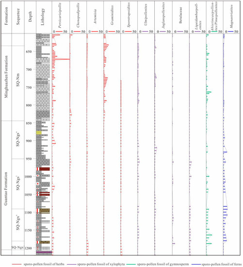
Figure 5.
Sporo-pollen fossils of well SS1.
4.3. Types and Distribution Characteristics of Sedimentary Facies
4.3.1. Types of Sedimentary Facies
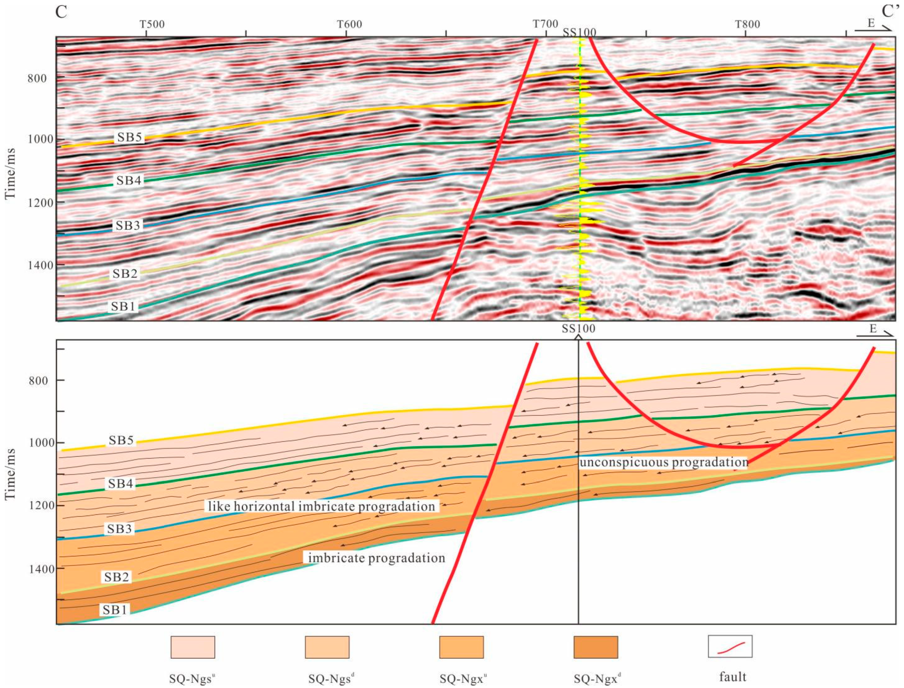
Through the analysis of well-logging and seismic data, it was concluded that the sandstone-mudstone assemblage in the study area presented the characteristics of progradation (Figure 3). The progradation reflection characteristics can be seen from the seismic profile (Figure 6), which has obvious similarities with the delta sedimentary sequence. In addition, through the analysis of the paleo-slope, it was found that the topographic slope of this area in the Neogene period was approximately 4°, which is not suitable for forming a shallow-water delta. Therefore, it can be inferred that a river-delta sedimentary system under a lacustrine background developed in the eastern Liaodong area. Combined with the comprehensive analysis of the core, logging and seismic data, it was considered that there were mainly three sedimentary facies: the braided river delta, meandering river delta, and meandering river. Among them, we have coring data of the braided river delta plain and meandering river delta front, while the other sedimentary facies were mainly analyzed according to the logging data (Figure 7).
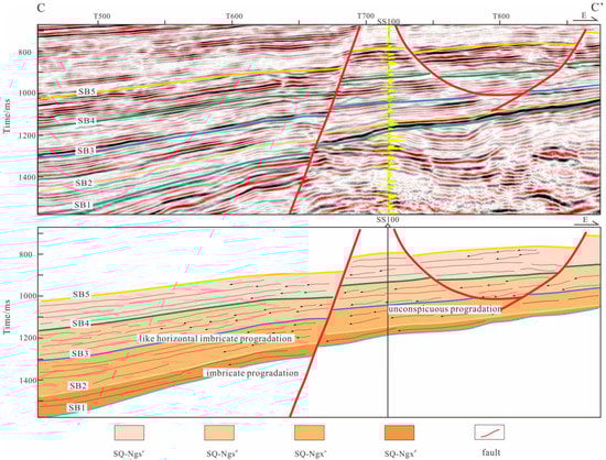
Figure 6.
Seismic profile and sedimentary facies reflection characteristics in EW direction of well-crossing in the eastern Liaodong area (see Figure 1c for profile position).
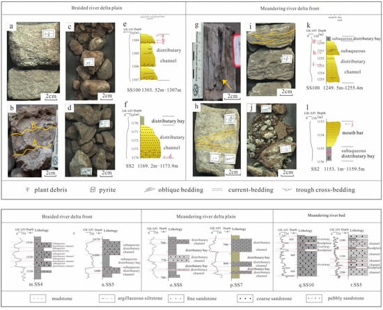
Figure 7.
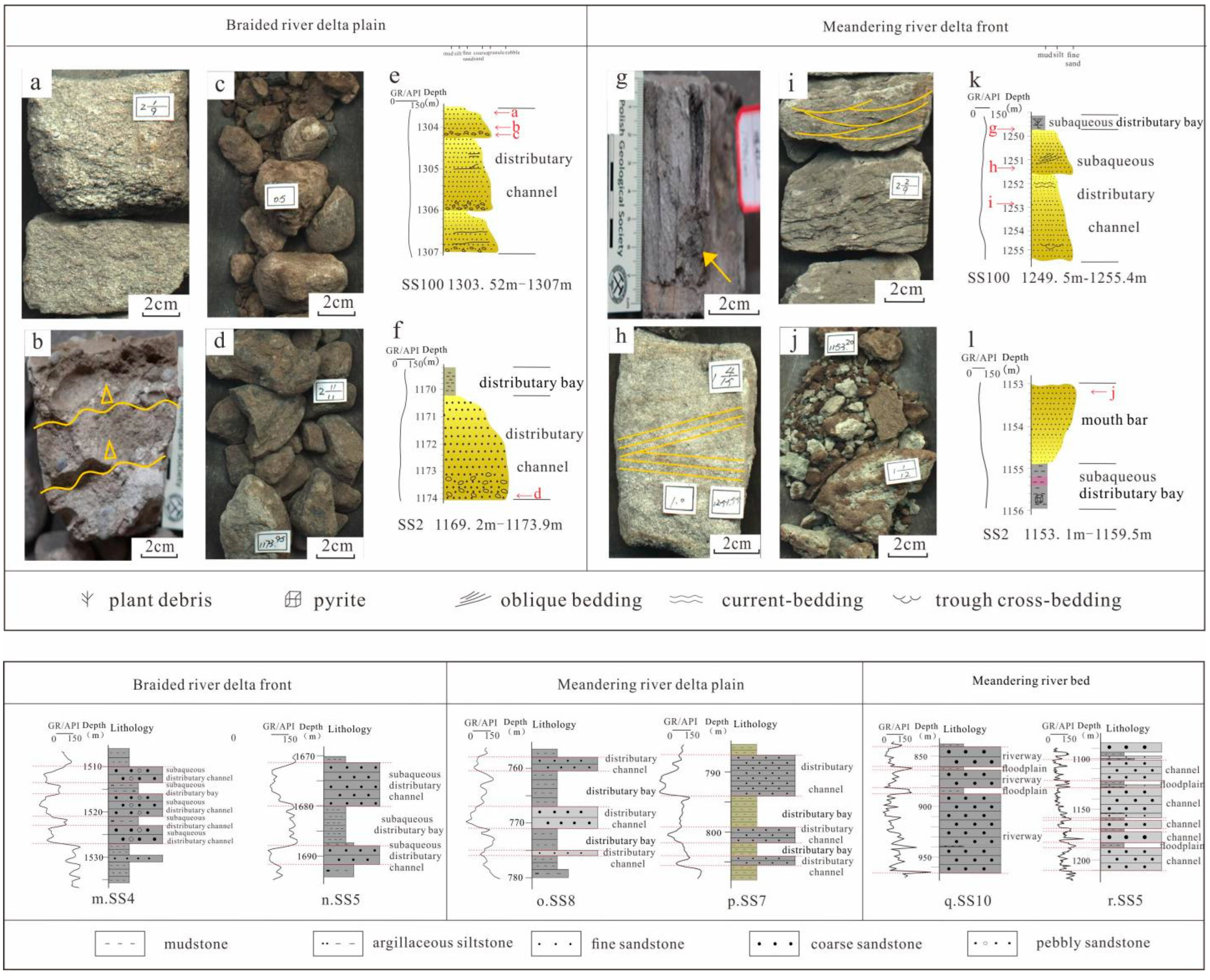
Typical lithological assemblages and sedimentary structures of the Neogene in the eastern Liaodong area. (a–d) Photograph of core example (from wells SS100 and SS2) reflecting braided river delta plain. (a) Well SS100, 1303.6 m, gray-white gravel coarse sandstone. (b) Well SS100, 1304 m gray-white gravel sandstone (scour surface visible). (c) Well SS100, 1304.3 m gray conglomerate. (d) Well SS2, 1173.9 m, gray conglomerate. (e) The core description of well SS100 (1303.52 m–1307 m). (f) The core description of well SS2 (1169.2 m–1173.9 m). (g–j) Photograph of core example (from wells SS100 and SS2) reflecting meandering river delta front. (g) Well SS100, 1248.5 m, gray siltstone (including plant debris). (h) Well SS100, 1251.5 m, grayish-brown fine sandstone with oblique bedding. (i) Well SS100, 1252.9 m, gray argillaceous siltstone, carbon-bearing debris (strip distribution), wavy bedding and small trough cross-bedding. (j) Well SS2, 1153.2 m, light-gray fine sandstone. (k) The core description of well SS100 (1249.5 m-1255.4 m). (l) The core description of well SS2 (1153.1 m–1159.5 m). (m,n) Typical well section (from wells SS4 and SS5) reflecting braided river delta front. (o,p) Typical well section (from wells SS8 and SS7) reflecting meandering river delta plain. (q,r) Typical well section (from wells SS10 and SS5) reflecting meandering river bed.
- Braided River Delta
The braided river delta develops at the bottom of the SQ-Ngxl. There are three sedimentary microfacies: the distributary channel, subaqueous-distributary channel and subaqueous-distributary bay. The lithology of the distributary channel was coarse as a whole and included gray conglomerate, gravel-bearing sandstone and gravel-bearing coarse sandstone (Figure 7a–d). The gravel was cobblestone-shaped, poorly sorted, and 2–5 cm in diameter, showing a positive fining-upward sequence. The logging curves were mainly bell-shaped (Figure 7e,f). The lithology of the subaqueous-distributary channel was mainly of gravel-bearing sandstone and fine sandstone, and the logging curves showed a medium-amplitude normal cycle, and the shapes were box-shaped, bell-shaped or composite shapes (Figure 7m,n). The subaqueous-distributary bay is located on both sides of the subaqueous-distributary channel, and its lithology was mainly gray and gray-green mudstone, interlayered with thin siltstone. The logging curve was generally a low-amplitude and straight. Thus, an obvious sand–mud boundary can be seen in the profile (Figure 7f,m,n).
The braided river delta is characterized by progradation reflection in the seismic profile and presents an imbricate-inclined reflection, which does not extend far between the upper and lower parallel reflections, representing a strong current progradation in a shallow-water environment in the slope area (Figure 6).
- 2.
- Meandering River Delta
The meandering river delta developed in the SQ-Ngxu, SQ-Ngsl and SQ-Ngsu, and mainly included four sedimentary microfacies: the distributary channel, subaqueous-distributary channel, estuary bar, and subaqueous-distributary bay.
The lithology of the distributary channel was of a gray-white medium sandstone, gray or grayish-brown fine sandstone, with the logging curves being box-shaped or bell-shaped, and with obvious toothed characteristics (Figure 7o,p). The lithology of the subaqueous-distributary channel was a gray fine sandstone and siltstone. On the core samples, the grain size gradually changed. The oblique bedding (Figure 7h), wavy bedding and small trough cross-bedding (Figure 7i) could be found in the sandstone. The logging curves were mainly bell-shaped and box-shaped (Figure 7k). The lithology of the estuary bar was mainly a silty fine sandstone, and the logging curve was funnel-shaped, showing the characteristics of a reverse rhythm (Figure 7j,l). The lithology of the subaqueous-distributary bay was gray-green with gray mudstone, containing a small amount of silt, pyrite, plant debris, etc., representing a quiet water deposition in a weak reduction environment with straight logging curves and low-amplitude (Figure 7g,k,l).
The meandering river delta mostly showed a weak progradational reflection configuration on the seismic profile, showing the characteristics of similar horizontal, intermittent imbricate progradation and recessive progradation, reflecting the sedimentation of sand bodies under shallow water, with a medium to weak-medium amplitude and a differential continuous reflection (Figure 6).
- 3.
- Meandering River
The meandering river developed in the SQ-Nm. It was mainly composed of river channel sediments, including gray-white coarse sandstone, medium sandstone, gravel-bearing sandstone, and a small amount of fine gray sandstone. The logging curves were box-shaped and had a toothed phenomenon (Figure 7q,r).
4.3.2. Distribution Characteristics of Sedimentary Facies
Jiaoliao Massif continued to supply the source sediments to the eastern Liaodong area during the Neogene. After restoring the paleogeomorphology in the study area using the flattening method, combined with the study of sequence stratigraphy and sedimentary facies, we analyzed the distribution characteristics of each sequence of the sedimentary system.
In the SQ-Ngxl, the distribution of the braided river delta was limited, and a large-scale denudation area developed at that time. The delta plain deposits range was large, and mainly included the delta plain distributary channel and delta front subaqueous-distributary channel deposits, and the overall lithology was coarse, mainly conglomerate, with gravelly sandstone and sandstone. The thickness of the single-layer sandstone was between 1–18 m, with an average of 4.6 m, and the sand-stratum ratio reached 60% (Figure 8 and Figure 9).
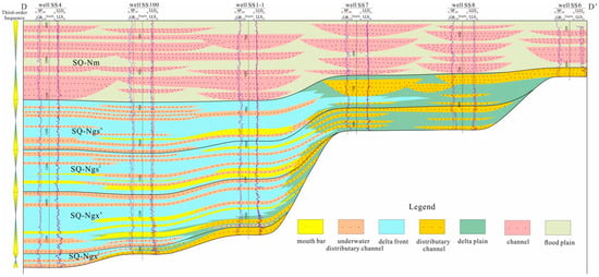
Figure 8.
Stratigraphic correlation section from Well SS4 to Well SS6 showing the distribution of sedimentary facies (see Figure 1c for profile position).
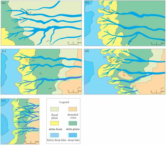
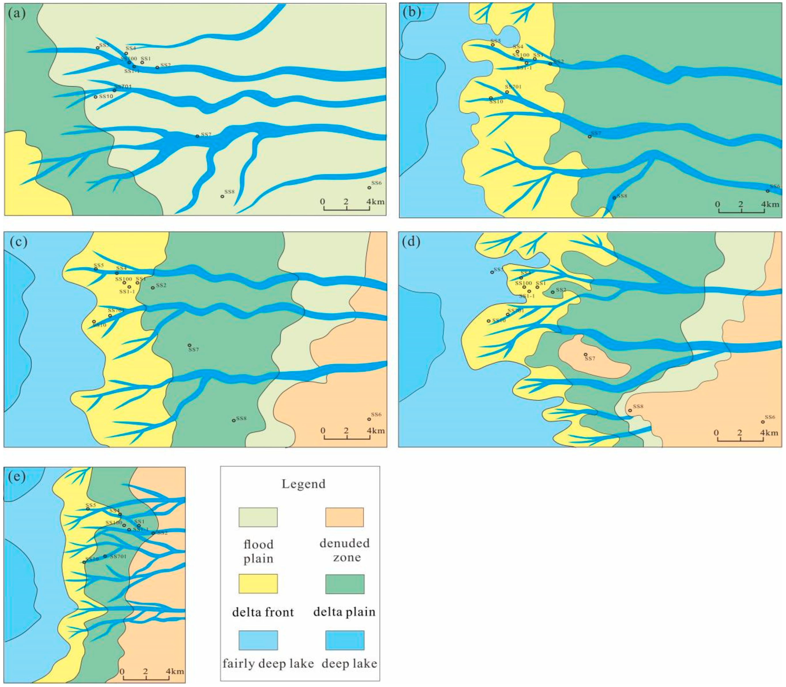
Figure 9.
Distribution of sedimentary facies in the eastern Liaodong area. (a) Facies distribution map of SQ-Nm. (b) Facies distribution map of SQ-Ngsu. (c) Facies distribution map of SQ-Ngsl. (d) Facies distribution map of SQ-Ngxu. (e) Facies distribution map of SQ-Ngxl.
In the SQ-Ngxu, the braided river delta gradually changed to the meandering river delta. The channel deposits spread over the well-SS701 area and well-SS1 area. The delta front sand body advanced far, and its distribution range was wide, but the scale of the southern sand body was small. Sedimentary microfacies were mainly the front subaqueous-distributary channels and estuary bars. The subaqueous-distributary channel was widely distributed transversely, and the multi-stage estuary bars could be seen deposited in front of the channel. The lithology was mainly gray mudstone mixed with thin siltstone and fine sandstone. The development of the subaqueous-distributary channels was relatively isolated; therefore, the superimposed channels were rare in the same period. The thickness of the single-layer sandstone was between 0.5–12 m, with an average of 2.9 m, and the sand-stratum ratio was only 30% (Figure 8 and Figure 9).
In the SQ-Ngsl and SQ-Ngsu, the ranges of the meandering river delta front and plain gradually enlarged, and the delta front sand body was widely distributed, showing the characteristics of the superimposed and contiguous distribution. Sedimentary microfacies were mainly front subaqueous-distributary channels, estuary bars and plain distributary channels. The lithology of the SQ-Ngsl was mainly mudstone interbedding with fine sandstone, and the subaqueous-distributary channels were superimposed vertically in multiple periods. The thickness of the single-layer sandstone was between 0.5–18 m, with an average of 4.5 m, and the sand-stratum ratio was about 44%. The lithology of the SQ-Ngsu was similar to that of the SQ-Ngsl, but the sandstone content obviously increased at the HST of the sequence. The gray-green mudstone deposits in the weak oxidation-weak reduction environment also appeared in the delta front, showing multi-stage superimposed channels, both vertically and transversely. The thickness of the single-layer sandstone ranged from 0.5 m to 28 m, with an average of 5.53 m, and the sand-stratum ratio was about 46% (Figure 8 and Figure 9).
In the SQ-Nm, it was dominated by a meandering river channel. In some areas, the channel’s sand bodies extended far toward the lake’s direction, and the channel’s sand bodies were superimposed vertically. The thickness of sandstone became larger, and its grain size was coarser than that of the meandering river delta deposits. The thickness of the single-layer sandstone was between 0.5–51.5 m, with an average of 13.5 m. The overall sand-stratum ratio of this sequence reached 76%, indicating that the provenance supply was sufficient at that time.
5. Discussion
5.1. Controlling Factors of Sedimentation
The study area is located at the basin margin of Bohai Bay Basin. The evolution of sedimentary types is more easily affected by the rise and fall of the lake’s level, so the periodic rise and fall of the lake’s level, which is caused by tectonic movement and paleoclimate change, is the fundamental factor controlling the vertical evolution of the sedimentary types. The transverse distribution of the sedimentary bodies in the basin’s margin zone is mainly controlled by aquatic valleys and subaqueous paleogeomorphic types.
5.1.1. Vertical Evolution of Sediments Controlled by Periodic Rise and Fall of Lake Level under the Influence of Tectonic Movement and Paleoclimate
Based on the study of sedimentary types and their distribution characteristics, it was considered that the sediments of the Neogene in the eastern Liaodong area have experienced an evolution from a braided river delta, meandering river delta, to a meandering river, which at first reflects the enlargement and then shrinkage of the lake’s basin range and the transportation’s distance change of provenance. In the sedimentary period of the SQ-Ngxl, the Bohai Bay Basin was at the stage of shrinkage rifting to post-rifting thermal subsidence [50]. Since the area was located in the descending plate of the Bodong No. 3 fault, the study area was deeply influenced by tectonic fault activities. Coupled with the warm and humid subtropical climate at this period [51,52], seasonal floods, strong erosion of the upthrown block, and sufficient material supply, the clastic materials from near the source formed a set of braided river delta deposits with coarse grain sizes and a rapid accumulation on the unconformity surface at the bottom of the Guantao Formation in the study area. During the sedimentary period of the SQ-Ngxu, Bohai Bay Basin officially entered the stage of thermal subsidence depression, and the paleoclimate was still a warm and humid subtropical climate. With the rise in the base level, the lake level rose rapidly, and the accommodation space increased rapidly, thus entering the lake-expanding stage. During this period, the denudation area moved eastward, and the transportation distance of provenance increased; therefore, the study area gradually transited into a distal-meandering river delta. The sandstone content decreased obviously, and the mudstone in the lake-expanding stage was relatively stable, forming a set of regional caprock. During the sedimentary period of the SQ-Ngsl and SQ-Ngsu, a tectonic heating event occurred in the Bohai Sea because of the reactivation of geological tectonic movement [50]. At that time, the activity of the Tan-Lu Fault zone intensified, and the strike-slip compression was stronger, which led to the weakening of the base-level rising-rate compared with the sedimentary period of the SQ-Ngxu. During this period, the whole strata entered the HST stage, with the thickness of single-layer sandstone and the sand-stratum ratio increasing, forming a set of stable distributed reservoirs in the whole region. In the sedimentary period of the SQ-Nm, the paleoclimate became dry and cool, and the lake level decreased rapidly, thus, the lake basin shrank westward, and the subsidence center moved rapidly to the Bozhong Sag due to the influence of neotectonic movement [35,50]. During this period, the meandering river deltas and lakes gradually disappeared in the study area and evolved into meandering rivers.
5.1.2. Transverse Distribution of Sediments Controlled by Paleogeomorphic Background under the Influence of Strike-Slip Faults
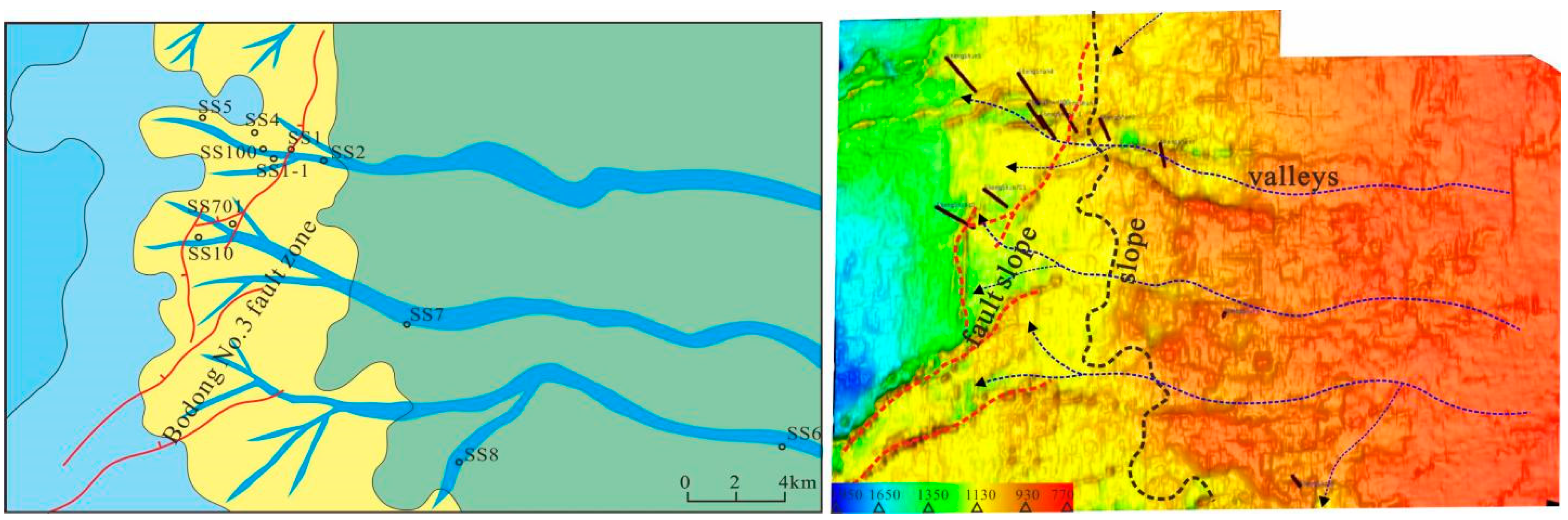
The periodic fluctuation of lake levels in the study area controlled macroscopic sedimentary evolution, while the strike-slip faults and paleogeomorphic background under their control affect the sedimentary distribution in the region. The paleogeomorphology of the study area in the Neogene includes a slope, fault slope and paleo-valley. The slope, which refers to the topographic slope developed in the background of a buried hill, determines the sedimentary filling rate and the macroscopic direction of alluvium. Fault slope, which refers to the NNE syn-sedimentary fault formed by the Bodong No. 3 branch fault, determines the provenance’s advancing direction and sand body distribution in the early Neogene sedimentation. Paleo-valley is mainly a fault ditch formed by three groups of nearly EW strike-slip fault systems in the study area, which is an important channel for debris to be transported from the denudation area to the sedimentary area. Different paleogeomorphic combinations lead to different paleogeomorphic characteristics in different periods, and then control sedimentary systems’ distribution and their spatial and temporal differences (Figure 10).
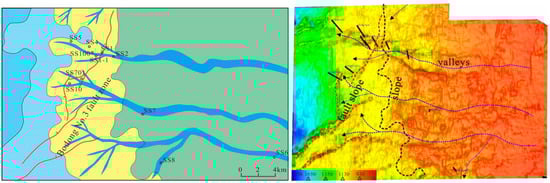
Figure 10.
Sedimentary facies distribution and paleogeomorphology map of SQ-Ngxu in the eastern Liaodong area.
The sedimentary paleogeomorphology of the SQ-Ngxl was dominated by valley and fault slopes. The sedimentary area was below the fault slope-break zone, adjacent to the provenance. Under the control of a relatively steep fault slope, the provenance advancing distance was limited, and only small-scale braided river deltas developed in the downthrown block of the Bodong No. 3 fault. When it came to the SQ-Ngxu, the shoreline of the lake moved eastward. However, there were still some local uplifts that were eroded in the study area. The paleogeomorphology consisted of the slope, valley and fault slope. Among them, the wide and gentle slope controlled the development of a large-scale delta plain, forming a delta-front area from the end of the slope to the bottom of the fault slope. Three main paleo-valleys and several secondary valleys were the main channels transporting sand, which determined the distribution of distributary channels in the delta plain and the extension direction of the front sand body. The fault slope played a redistribution role in the distribution of the delta front sand body. The delta sand body gradually spread out at the front end of the fault slope, showing a skirt-shaped distribution. In the sedimentary period of the SQ-Ngsl and SQ-Ngsu, the paleogeomorphology inherited the features of that in the SQ-Ngxu sedimentary period. The scope of the sedimentary filling further expanded, and the local paleo-uplift completely disappeared. The paleo-valley still served as the main sand-transport channel, and the corresponding relationship between the valley and fan was good. By the sedimentary period of the SQ-Nm, the height difference in the paleogeomorphology in the study area gradually narrowed under the action of a filling depression. The paleogeomorphology was dominated by a wide gentle slope and inherited paleo-valley, and the channel direction was controlled by a paleo-valley (Figure 9 and Figure 10).
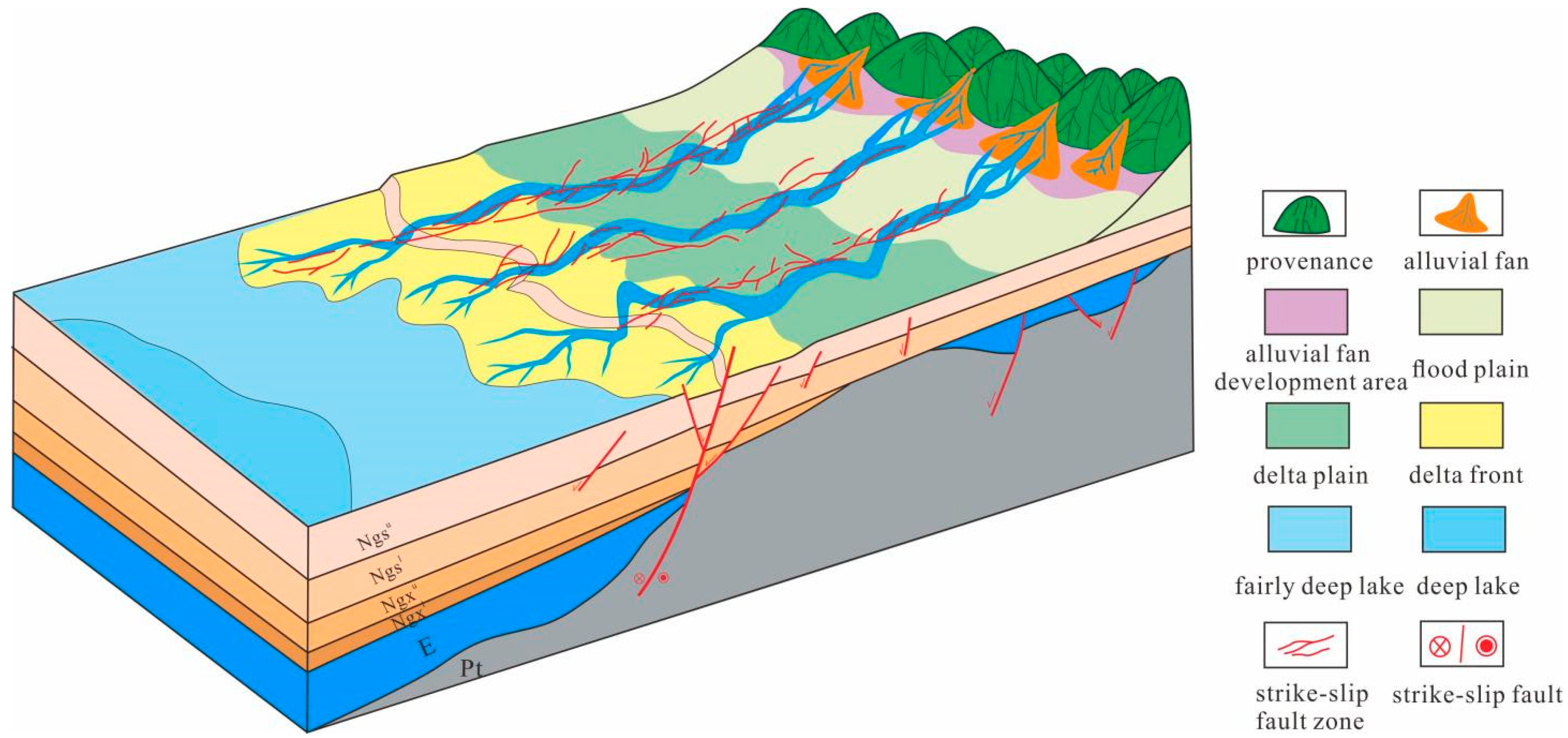
5.2. Depositional Model
During the Neogene sedimentary period in the eastern Liaodong area, sedimentary fillings were controlled by paleotectonics, paleoclimate and paleogeomorphology, making a depositional model in which the slopes controlled facies, the valleys controlled rivers, and the fault slopes controlled sand bodies. The topography in this period was relatively gentle, higher in the east and lower in the west. The provenance was continuously provided by Jiaoliao Massif in the east. The wide slope determined the alluvial direction of the river, which was from east to west, thus controlling the distribution of the delta plain. Influenced by the topographic gradient, the sedimentary sub-facies gradually changed into the delta front. The end of the slope was affected by the Bodong No. 3 strike-slip fault, and the front sand body was redistributed along with the fault-slope break zone. Furthermore, it was easy to form delta front leaf bodies at the side position of the strike-slip fault. There are three strike-slip fault zones conjugated with the Bodong No. 3 fault in the study area. The fault ditches formed by these strike-slip fault zones determine the development position and strike of paleo-gullies and then control the position and alluvial direction of the channels. Among these strike-slip fault zones, the Penglai No. 3 fault in the north has the strongest activity and the largest scale, and its controlled channel has the farthest extension and largest scale (Figure 11).
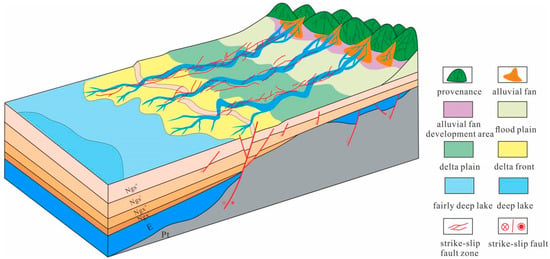
Figure 11.
Typical depositional model map of Neogene in the eastern Liaodong area.
6. Conclusions
- The Neogene strata in the eastern Liaodong area can be divided into five third-order sequences. Only the SQ-Ngxl at the bottom lacks lacustrine TST, while all the other sequences consist of LST, lacustrine TST and HST.
- The Neogene sediments in the eastern Liaodong area are under the delta-fluvial sedimentary system. In this system, three sedimentary facies, which are the braided river delta, meandering river delta and meandering river, and eight sedimentary microfacies, can be identified. The sedimentary evolution can be divided into four stages: braided river delta, meandering river delta with a low sand-stratum ratio, meandering river delta with a high sand-stratum ratio, and meandering river delta.
- The sedimentary fillings evolution is controlled by tectonic movement, paleoclimate and paleogeomorphology. The vertical evolution of the sediments is controlled by a periodic rise and fall of the lake’s level under the influence of tectonic movement and paleoclimate, while the transverse distribution of the sediments is controlled by a paleogeomorphic background under the influence of strike-slip faults. Therefore, a depositional model, in which the slopes control facies, the valleys control rivers and the fault slopes control sand bodies, can be established.
Author Contributions
Conceptualization, R.H. and Y.W.; methodology, Y.W.; software, R.H.; validation, Y.W., J.W. and Z.W.; formal analysis, R.H. and Q.W.; investigation, R.H.; resources, A.J.; data curation, X.L.; writing—original draft preparation, R.H.; writing—review and editing, Y.W. and J.W.; visualization, R.H.; supervision, H.X.; project administration, X.L.; funding acquisition, A.J. and R.H. All authors have read and agreed to the published version of the manuscript.
Funding
This research was funded by the Science and Technology Major Project of China, grant number 2016ZX05006. This work was also supported by the Natural Science Foundation of Shandong Province (No.ZR2021QD012).
Institutional Review Board Statement
Not applicable.
Informed Consent Statement
Not applicable.
Data Availability Statement
The data presented in this study cannot be shared at this time due to further ongoing studies.
Conflicts of Interest
The authors declare no conflict of interest.
References
- Baum, G.; Vail, P. Sequence stratigraphic concepts applied to Paleogene outcrops, Gulf and Atlantic Basins. In Sea Level Changes: An Integrated Approach; SEPM Special Publication: Tulsa, Oklahoma, 1988; Volume 42, pp. 309–327. [Google Scholar]
- Vakarcs, G.; Vail, P.R.; Tari, G. Third-order Middle Miocene-Early Pliocene depositional sequences in the prograding delta complex of the Pannonian Basin. Tectonophysics 1994, 240, 81–106. [Google Scholar] [CrossRef]
- Zhang, Z.L.; Zhu, X.M.; Zhang, R.F. To establish a sequence stratigraphy in lacustrine rift basin: A 3D seismiccase study from paleogene Baxian Sag in Bohai Bay Basin, China. Mar. Pet. Geol. 2020, 120, 104505. [Google Scholar] [CrossRef]
- Xia, S.Q.; Lin, C.S.; Wu, W. Sequence architecture, depositional evolution and responses to tectonic subsidence and lacustrine fluctuation in lacustrine rift basin: A case study from Cenozoic Liaodong Bay, Bohai Bay Basin. J. Pet. Sci. Eng. 2022, 208, 109494. [Google Scholar] [CrossRef]
- Xu, X.; Liu, L.Y. Sequence stratigraphy, sedimentary characteristics of barrier coastalsedimentary system of the Benxi Formation (Gaoqiao area, Ordosbasin) and favorable reservoir distribution. Energy Rep. 2021, 7, 5316–5329. [Google Scholar] [CrossRef]
- Wang, S.Q.; Lin, C.S.; Li, H. Sequence stratigraphy and sedimentary characteristics of the shelf-edge delta and slope fan systems in the Late Oligocene, Baiyun Sag, Pearl River Mouth Basin, China. Mar. Pet. Geol. 2022, 136, 105441. [Google Scholar] [CrossRef]
- Hassan, M.H.; Johnson, D.H.; Allison, P.A. Sedimentology and stratigraphic development of the upper NyalauFormation (Early Miocene), Sarawak, Malaysia: A mixed wave-and tide-influenced coastal system. J. Asian Earth Sci. 2013, 76, 301–311. [Google Scholar] [CrossRef]
- Ge, J.W.; Zhao, X.M.; Tan, M.X. Sequence stratigraphy and depositional evolution of the north-eastern shelf (33.9–10.5 Ma) of the Pearl River Mouth basin, South China Sea. Mar. Pet. Geol. 2022, 141, 105697. [Google Scholar] [CrossRef]
- Shang, W.L.; Xu, S.H.; Mao, Z.Q. High-resolution sequence stratigraphy in continental lacustrine basin: A case of Eocene Shahejie formation in the Dongying Depression, Bohai Bay Basin. Mar. Pet. Geol. 2022, 136, 105438. [Google Scholar] [CrossRef]
- Xu, C.G.; Huan, L.; Song, Z.Q. Sequence stratigraphy of the lacustrine rift basin in the Paleogene system of the Bohai Sea area: Architecture mode, deposition filling pattern, and response to tectonic rifting processes. Interpretation 2020, 8, SF57–SF79. [Google Scholar] [CrossRef]
- Liu, L.; Chen, H.D.; Wen, H.G. Facies architecture and sediment infilling processes in intrabasinal slopebelts of lacustrine rift basins, Zhanhua Depression, Bohai Bay Basin. Mar. Pet. Geol. 2020, 112, 104089. [Google Scholar] [CrossRef]
- Li, X.P.; Wang, H.; Gan, H.J. Stratigraphic charactertistic and tectonic control on the paleogene sedimentary evolution of the Baxian Half-graben, Bohai Bay Basin, east China. J. Pet. Sci. Eng. 2019, 181, 106145. [Google Scholar] [CrossRef]
- Li, Q.; Zhang, Z.L.; Zhang, J. Characteristics of sedimentary differential response for multi-episode rifting cycles in lacustrine rift basin: A case study of the Palaeogene Baxian sag in the Bohai Bay Basin. Mar. Pet. Geol. 2022, 136, 105426. [Google Scholar] [CrossRef]
- Sun, L.D.; Fang, C.L.; Li, F. Petroleum exploration and development practices of sedimentary basins in China and research progress of sedimentology. Pet. Explor. Dev. 2010, 37, 385–396. [Google Scholar]
- Zeng, H.L.; Zhao, X.Z.; Zhu, X.M. Seismic sedimentology of sub-clinoformal shallow-water meandering river delta: A case from the Suning area of Raoyang sag in Jizhong depression, Bohai Bay Basin, NE China. Pet. Explor. Dev. 2015, 42, 621–632. [Google Scholar] [CrossRef]
- Li, Y.; Fan, A.P.; Yang, R.C. Sedimentary facies control on sandstone reservoir properties: A case study from the permian Shanxi Formation in the southern Ordos basin, central China. Mar. Pet. Geol. 2021, 129, 105083. [Google Scholar] [CrossRef]
- Aigbadon, G.O.; Christopher, S.D.; Akudo, E.O. Sedimentary facies and textural characteristics of Cretaceoussandstones in the southern Bida Basin, Nigeria: Implication forreservoir potential and depositional environment. Energy Geosci. 2022, 3, 323–341. [Google Scholar] [CrossRef]
- Zeng, Z.W.; Zhu, H.T.; Zeng, H.L. Seismic sedimentology analysis of fluvial-deltaic systems in a complex strike-slip fault zone, Bohai Bay Basin, China: Implications for reservoir prediction. J. Pet. Sci. Eng. 2022, 208, 109290. [Google Scholar] [CrossRef]
- Deng, Y.H.; Li, J.P. Formation Mechanism of Shallow Oil and Gas Reservoirs: A Case Study of Bohai Oil Area; Petroleum Industry Press: Beijing, China, 2008; pp. 23–28. [Google Scholar]
- Zhu, W.L.; Mi, L.J.; Gong, Z.S. Hydrocarbon Accumulation and Exploration in Bohai Sea Area; Science Press: Beijing, China, 2009; pp. 41–44. [Google Scholar]
- Yang, H.F.; Xu, C.G.; Gong, Z.S. Quantitative evaluation of hydrocarbon accumulation pattern and the controlling factors in the Neogene of Huanghekou Sag, Bohai Bay Basin. Oil Gas Geol. 2020, 41, 259–269. [Google Scholar]
- Teng, C.Y.; Zou, H.Y.; Hao, F. Control of differential tectonic evolution on petroleum occurrence in Bohai Bay Basin. Sci. China Earth Sci. 2014, 57, 1117–1128. [Google Scholar] [CrossRef]
- Xu, C.G.; Jing, P.H.; Wu, F.D. Discovery and sedimentary characteristics of the Neogene delta in Bozhong Depression and its significance for oil and gas exploration. Acta Sedimentol. Sin. 2002, 20, 588–594. [Google Scholar]
- Xu, Z.H.; Wu, S.H.; Liu, Z. Sandbody architecture of the bar finger within shoal water delta front: Insights from the Lower Member of Minghuazhen Formation, Neogene, Bohai BZ25 Oilfield, Bohai Bay Basin, East China. Pet. Explor. Dev. 2019, 46, 322–333. [Google Scholar] [CrossRef]
- Zhu, W.L.; Li, J.P.; Zhou, X.H. Neogene Shallow Water Deltaic System and Large Hydrocarbon Accumulations in Bohai Bay, China. Acta Sedimentol. Sin. 2008, 44, 575–582. [Google Scholar]
- Wang, D.Y.; Yu, H.Z.; Yu, H.B. An analysis and refined depiction of lithologic trap development under the framework of Neogene sequence stratigraphy in Bohai water: A case of Lower Member of Minghuazhen Formation in Shijiutuo rise. China Offshore Oil Gas 2012, 24, 23–28. [Google Scholar]
- Tan, M.X.; Zhu, X.M.; Zhang, Z.L. Fluvial sequence pattern and its response of geomorphy in depression phase of rift basin: A case study of the Lower Member of Neogene Minghuazhen Formation in Shaleitian Uplift area, Bohai Bay Basin. J. Palaeogeogr. 2020, 22, 428–439. [Google Scholar]
- Zhao, H.Q.; Zhang, J.M.; Li, S.B. Sedimentary Characteristics and Evolution Models of Lower Part of Minghuazhen Formation in Neogene System in Oilfield A, Bohai Bay Basin. J. Jilin Univ. Earth Sci. Ed. 2017, 47, 1021–1029, 1046. [Google Scholar]
- Xu, C.G.; Yang, H.F.; Wang, D.Y. Formation conditions of Neogene large-scale high-abundance lithologic reservoir in the Laibei low uplift, Bohai Sea, East China. Pet. Explor. Dev. 2021, 48, 12–25. [Google Scholar] [CrossRef]
- Zhao, G.X.; Guan, D.Y.; Liu, P.B. Sedimentary Characteristics and Sand Body Evolution of Shallow Braided River Delta of Guantao Formation in Miaoxi’nan Uplift, Bohai Sea Area. Acta Sedimentol. Sin. 2018, 36, 807–817. [Google Scholar]
- Yang, G.L. Analysis on Oil/Gas Reservoir-forming Conditions in Eastern Liaodong Region, Bohai Sea. Spec. Oil Gas Reserv. 2014, 21, 76–79. [Google Scholar]
- Xiong, W.; Zhang, M.H.; Xu, H.Q. Oil and Gas Accumulation and Exploration Potential in the Shengshun Oilfield, the Bohai sea. Mar. Geol. Front. 2017, 33, 42–47. [Google Scholar]
- Xian, B.Z.; Wang, Z.; Ma, L.C. Paleao-Drainage System and Integrated Paleo-Geomorphology Restoration in Depositional and Erosional Areas: Guantao Formation in East Liaodong Area, Bohai Bay Basin. China. Earth Sci. 2017, 42, 1922–1935. [Google Scholar]
- Zhang, Y.; Yao, Y.J.; Li, X.J. Tectonic evolution and resource-environmental effect of China Seas and adjacent areas under the multisphere geodynamic system of the East Asia ocean-continent convergent belt since Mesozoic. Geol. China 2020, 47, 1271–1309. [Google Scholar]
- Zhang, X.Q.; Wu, Z.P.; Zhou, X.H. Cenozoic Tectonic Characteristics and Evolution of the Southern Bohai Sea. Geotecton. Metallog. 2017, 41, 50–60. [Google Scholar]
- Zhang, J.T.; Wu, K.; Wang, B.J. Apatite fission track evidence of Cenozoic tectonic evolution in the northern section of Liaoxi uplift, Bohai Sea. Acta Pet. Sin. 2018, 39, 1262–1271. [Google Scholar]
- Hou, G.T.; Qian, X.L. The Tectonic Evolution of Bohai Basin in Mesozoic and Cenozoic Time. Acta Sci. Nat. Univ. Pekin. 2001, 37, 845–851. [Google Scholar]
- Zhou, B.; Deng, Z.H.; Xu, J. Characteristics of neotectonism and their relationship with late hvdrocarbon accumulation in the Bohai sea. Prog. Geophys. 2009, 24, 2135–2144. [Google Scholar]
- Chang, Y.Y.; Lin, C.S.; Zhou, X.H. Depositional sequences and prediction of favorable reservoir sand of Shahejie Foramtion of Liaoxi Depression. Earth Sci. J. China Univ. Geosci. 2014, 39, 1371–1380. [Google Scholar]
- Feng, Y.L.; Zhou, H.M.; Ren, J.Y. The Paleogene stratigraphic sequences and its responses to tectonic activities in the eastern part of Bohai Bay Basin. Sci. China Earth Sci. 2010, 40, 1356–1376. [Google Scholar]
- Hsiao, L.Y.; Graham, S.A.; Tilander, N. Stratigraphy and sedimentation in a rift basin modified by synchronous strike-slip deformation: southern Xialiaohe basin, Bohai, offshore China. Basin Res. 2010, 22, 61–78. [Google Scholar] [CrossRef]
- Yu, Z.H. The Control of Sequence Stratigraphy and Tectonic on Sediment Filling on Neogene in Huanghekou Depression; China University of Geosciences: Beijing, China, 2009. [Google Scholar]
- Ju, Y.T. Study on Sequence Stratigraphy and Stuble Reservoir in the Huangjekou Sag, Bohai Bay Basin; China University of Geosciences: Beijing, China, 2012. [Google Scholar]
- Wang, Y.B.; Huang, L.; Liu, T.H. The main characteristics and tectonic types of neotectonic movement in Bohai Sea. China Offshore Oil Gas 2012, 24, 6–10. [Google Scholar]
- Li, C.Z.; Xu, G.S.; Xu, F.H. A model for faults to link the Neogene reservoirs to the Paleogene organic-rich sediments in low-relief regions of the south Bohai Sea, China. J. Pet. Sci. Eng. 2021, 200, 108360. [Google Scholar] [CrossRef]
- Jiang, Z.X. Advances in sequence stratigraphy: A summary from International Workshop on Sequence Stratigraphy. Earth Sci. Front. 2012, 19, 1–9. [Google Scholar]
- Jiang, Y.M.; Shao, L.Y.; Li, S. Deposition System and Stratigraphy of Pinghu Formation in Pinghu Tectonic Belt, Xihu Sag. Geoscience 2020, 34, 141–153. [Google Scholar]
- Xu, N.N.; Qiu, L.W.; Liu, K.Y. Sedimentary Facies of the Upper Part of the Fourth Menmber of the Shahejie Formation in the Bonan-Luojia Area of the Zhanhua Sag. J. Stratigr. 2015, 39, 223–231. [Google Scholar]
- Yuan, Q.; Barbolini, N.; Ashworth, L. Palaeoenvironmental changes in Eocene Tibetan lake systems traced by geochemistry, sedimentology and palynofacies. J. Asi. Earth Sci. 2021, 214, 104778. [Google Scholar] [CrossRef]
- He, J.X.; Zhang, W.; Yan, W. Episodic Tectonic Evolution, Basin Types and Hydrocarbon Accumlation in Chinese Marginal Basins. Mar. Geol. Quat. Geol. 2014, 34, 121–133. [Google Scholar] [CrossRef]
- Pan, W.J.; Du, X.F.; Wang, Q.B. Neocene Palaeontological Characteristics and Its Paleoenvironment Significance During the Withering Period of the Lacustring Basin in the Southeastern Bohia Sea, North China. Acta Micropalaeontol. Sin. 2018, 35, 238–249. [Google Scholar]
- Lai, W.C.; Cheng, J.C.; Zhou, X.H. Sedimentary sequence division and sand body characteristics of peneplain during lacustrine atrophy: A case study of the Lower Member of The Ming Neogene in the Yellow River Estuary. China Offshore Oil Gas 2009, 21, 157–161. [Google Scholar]


Publisher’s Note: MDPI stays neutral with regard to jurisdictional claims in published maps and institutional affiliations. |
© 2022 by the authors. Licensee MDPI, Basel, Switzerland. This article is an open access article distributed under the terms and conditions of the Creative Commons Attribution (CC BY) license (https://creativecommons.org/licenses/by/4.0/).