
Sedimentary Basin Water and Energy Storage: A Low Environmental Impact Option for the Bananal Basin

 ,
,  , ,
, ,  ,
,  , and
, and
Abstract
:1. Introduction
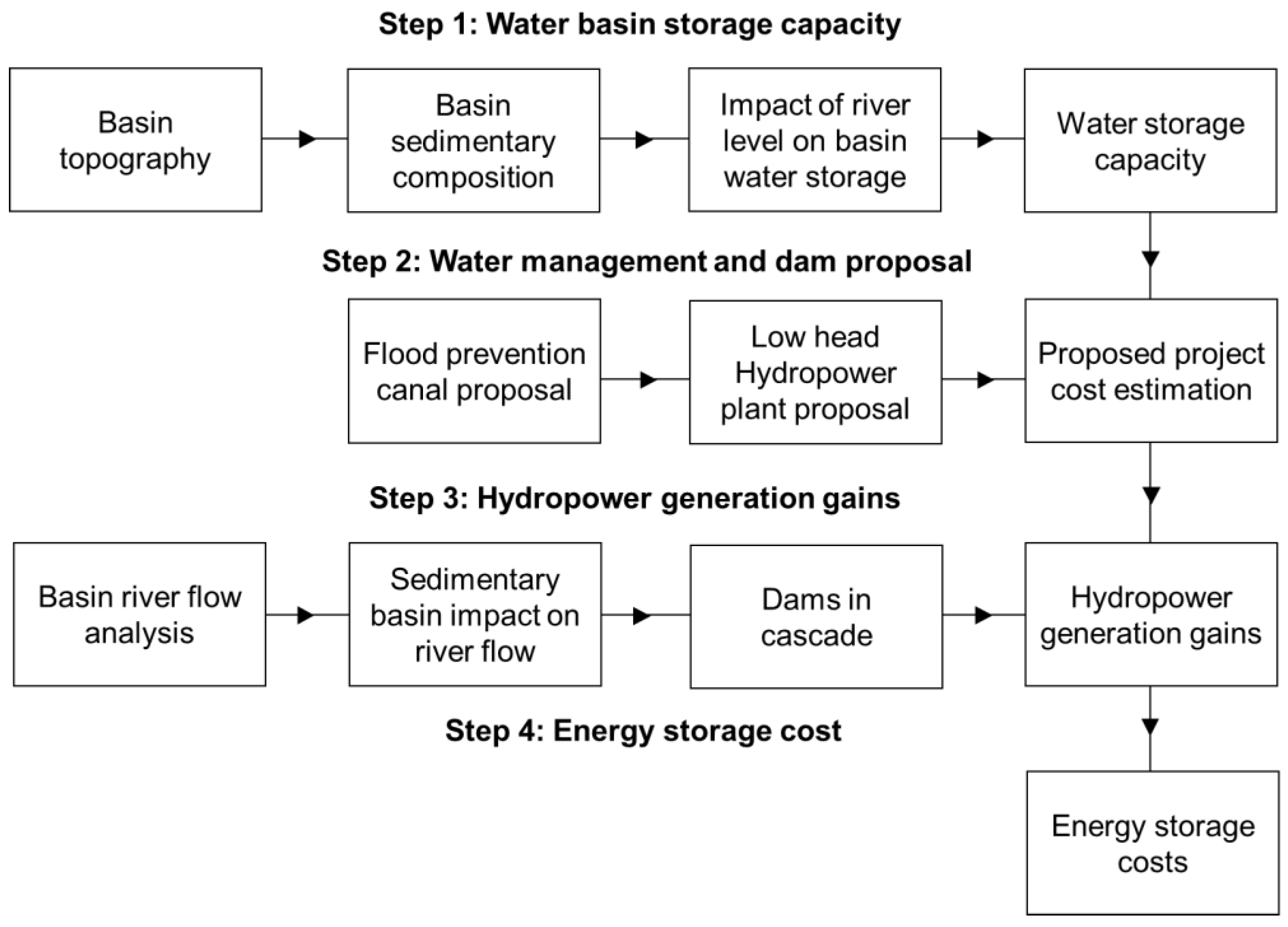
2. Methodology


| Step | Data | Description | Reference |
|---|---|---|---|
| 1 | Topographic data (STRM) | Data resolution of 3 s (equivalent to 90 × 90 m in the equator). | [33] |
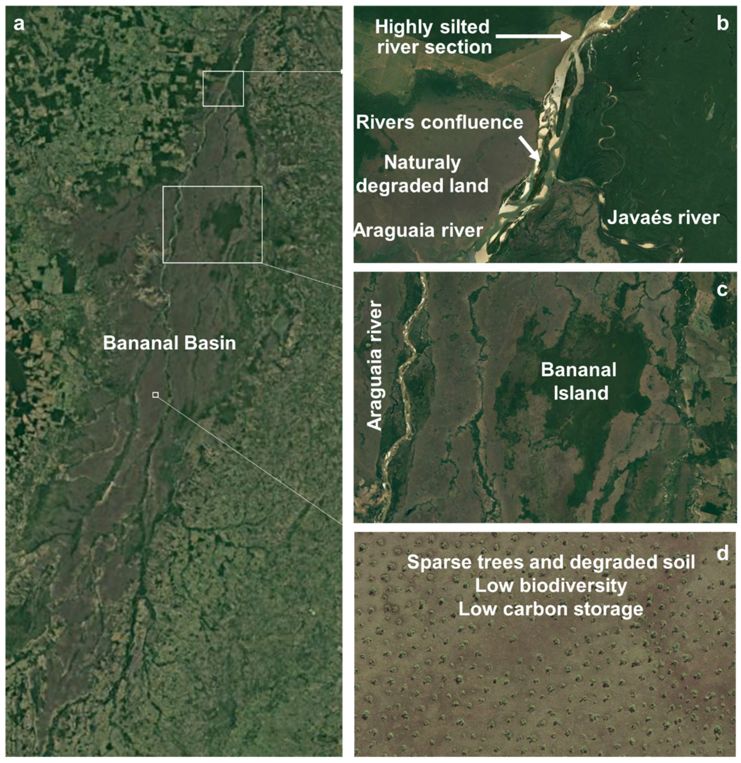
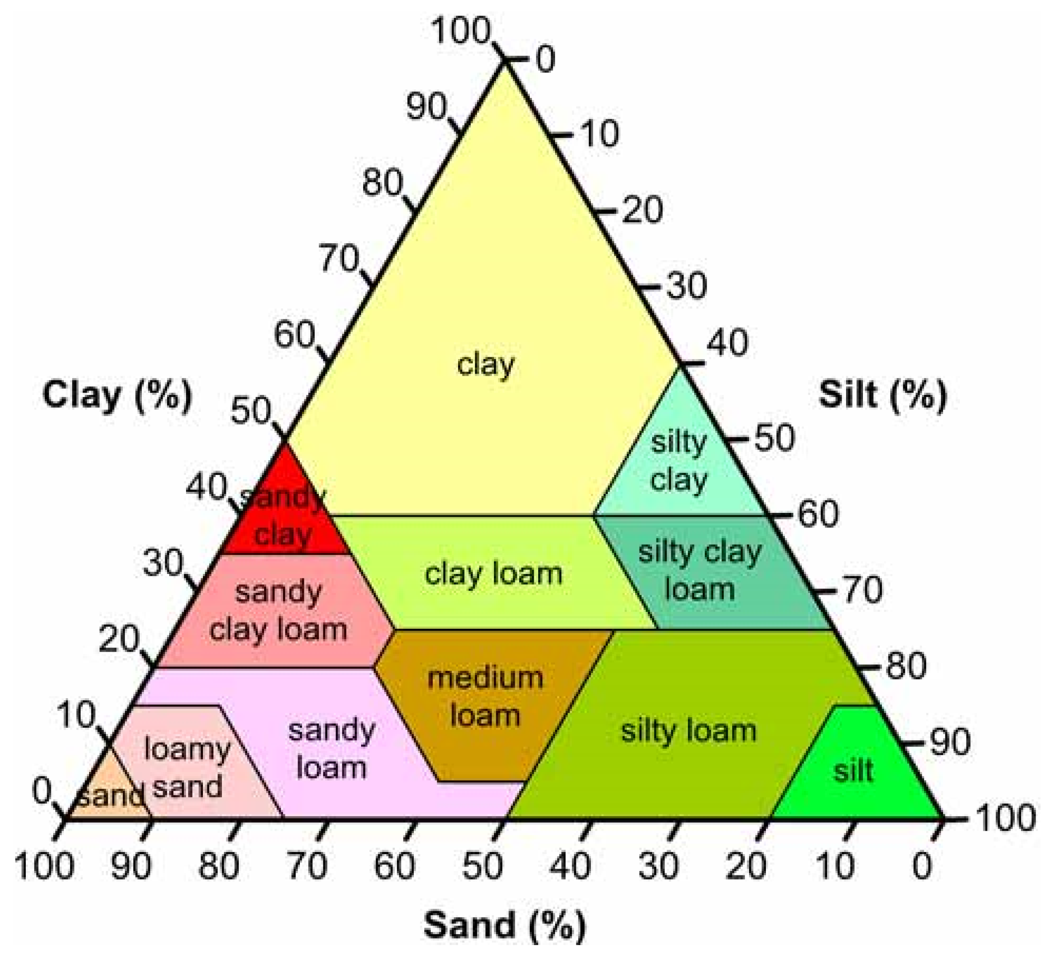
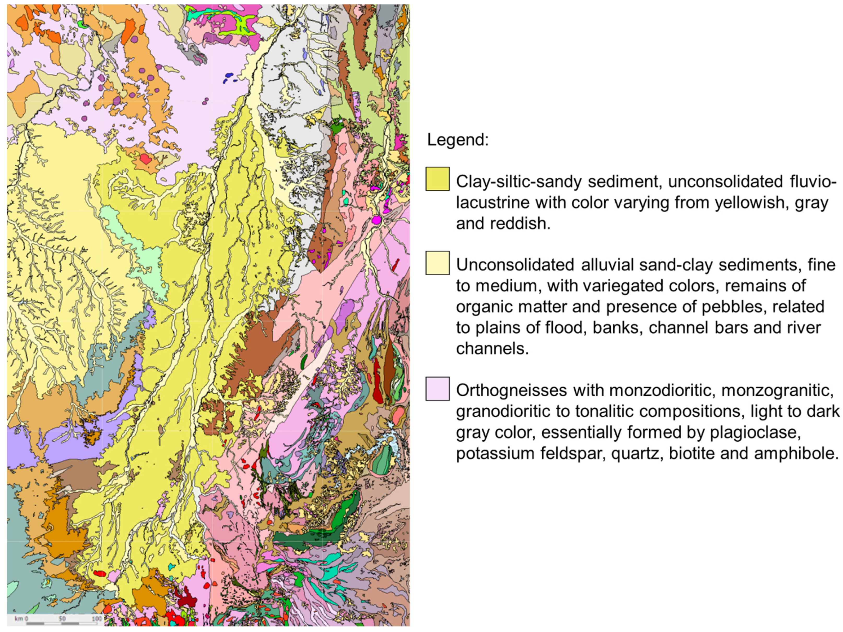
| Geological composition | Geological composition of the Bananal sedimentary basin consists of clay-silt-sandy sediment, unconsolidated fluviolacustrine with colour varying from yellowish, grey to reddish. Sand granulometry predominates. | [34] | |
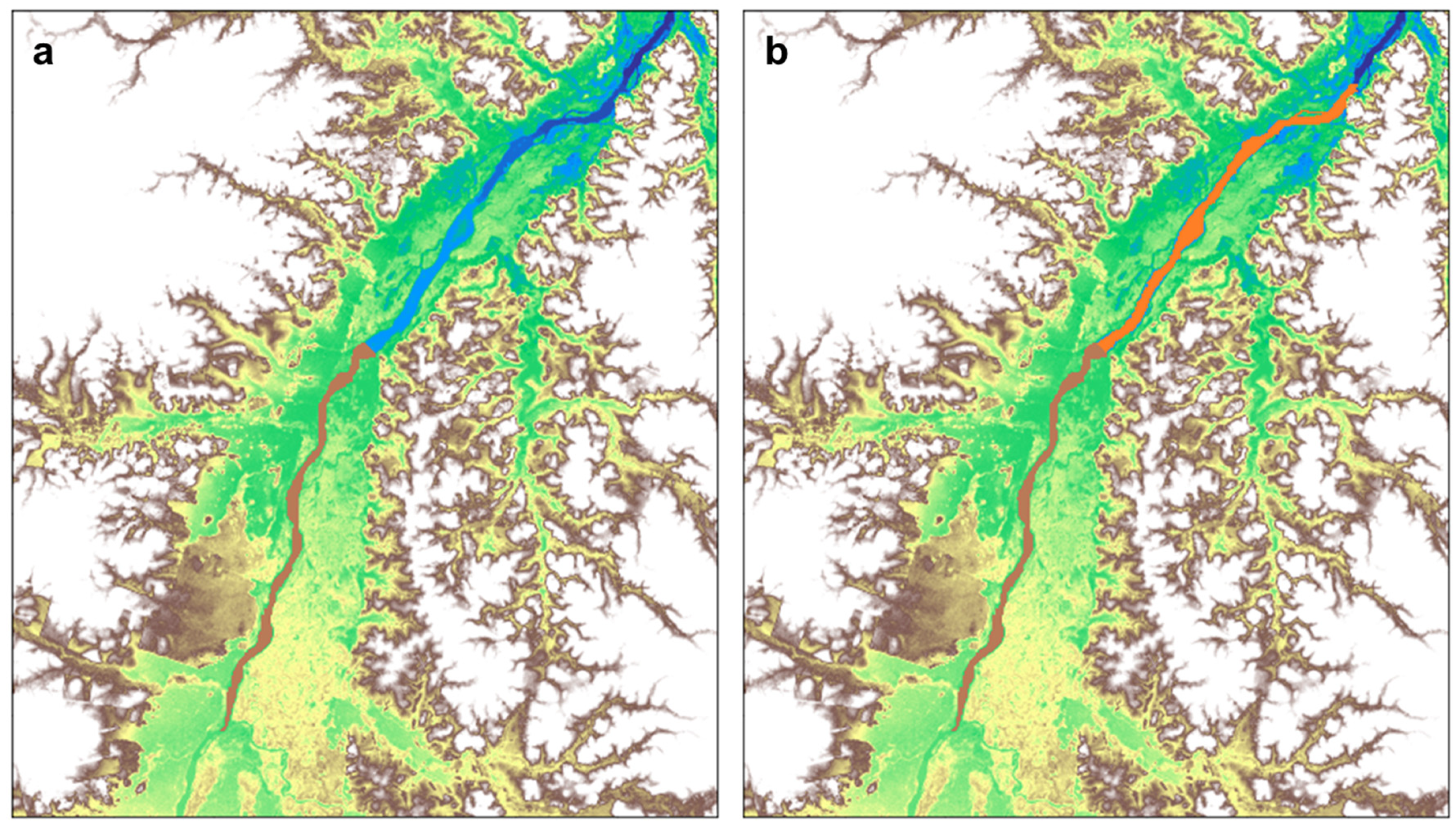
| Soil particle-size classes with different concentrations of sand, clay, and silt are presented in Figure 6. | [35] | ||
| The available water storage capacity for different soil particle-size classes is presented in Table 2. This paper assumes that the available water capacity (AWC) is 0.18 cm3/cm3. That is, 18% of the soil volume can store water. | [36] | ||
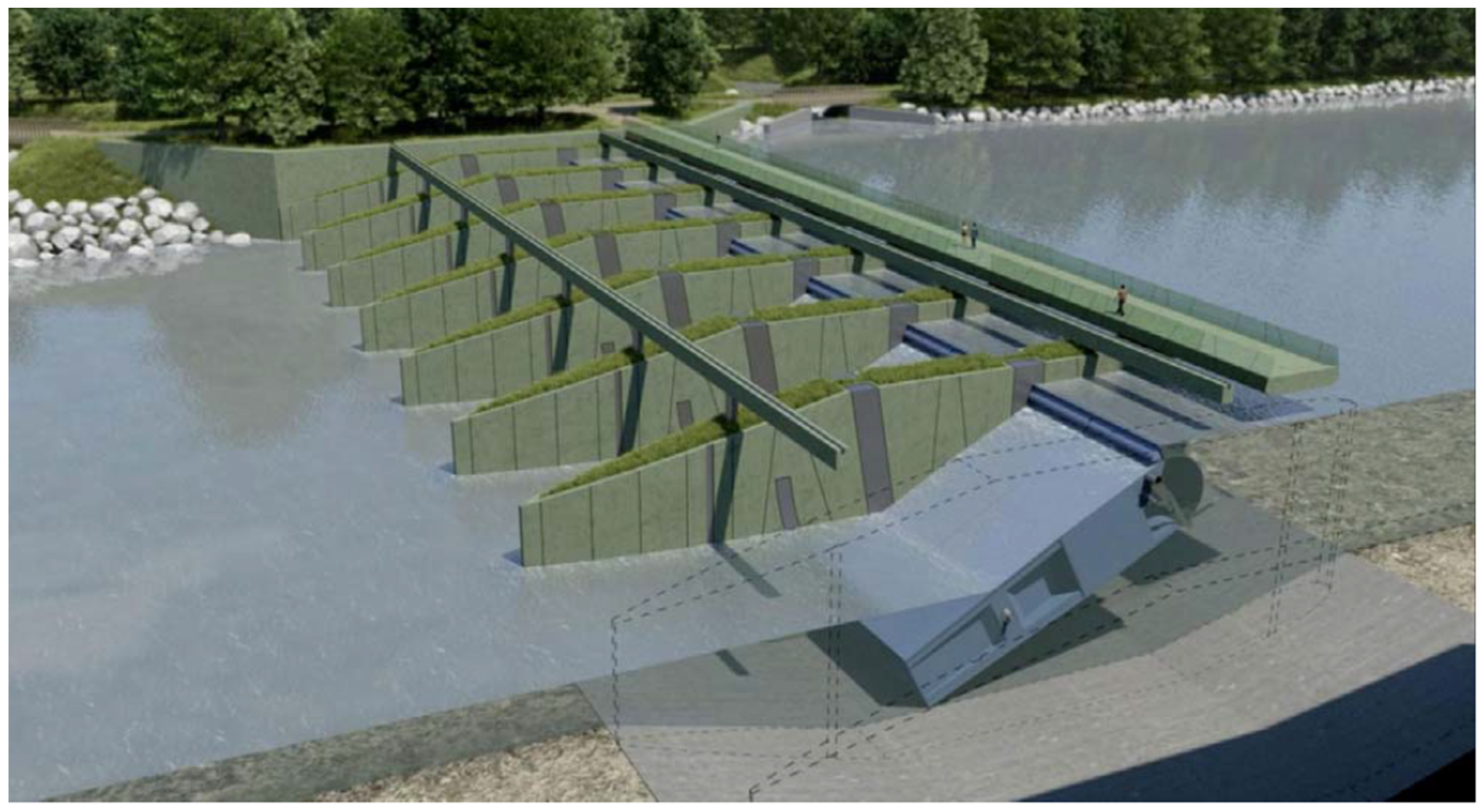
| 2 | Proposed project cost estimation | Data on the cost estimates for the flood prevention canals and the low head hydropower plants to estimate the energy storage costs of the project. | [37] |
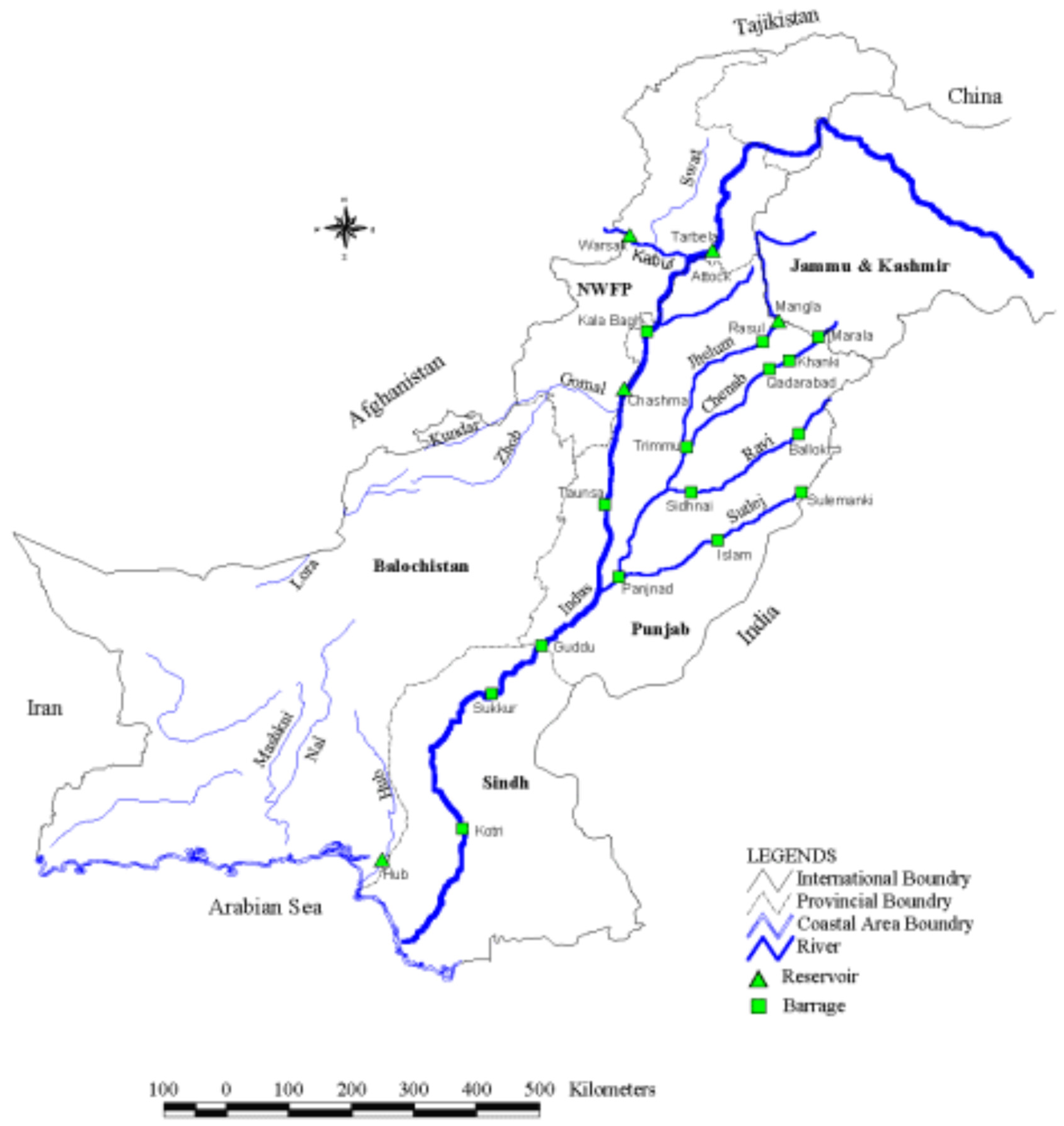
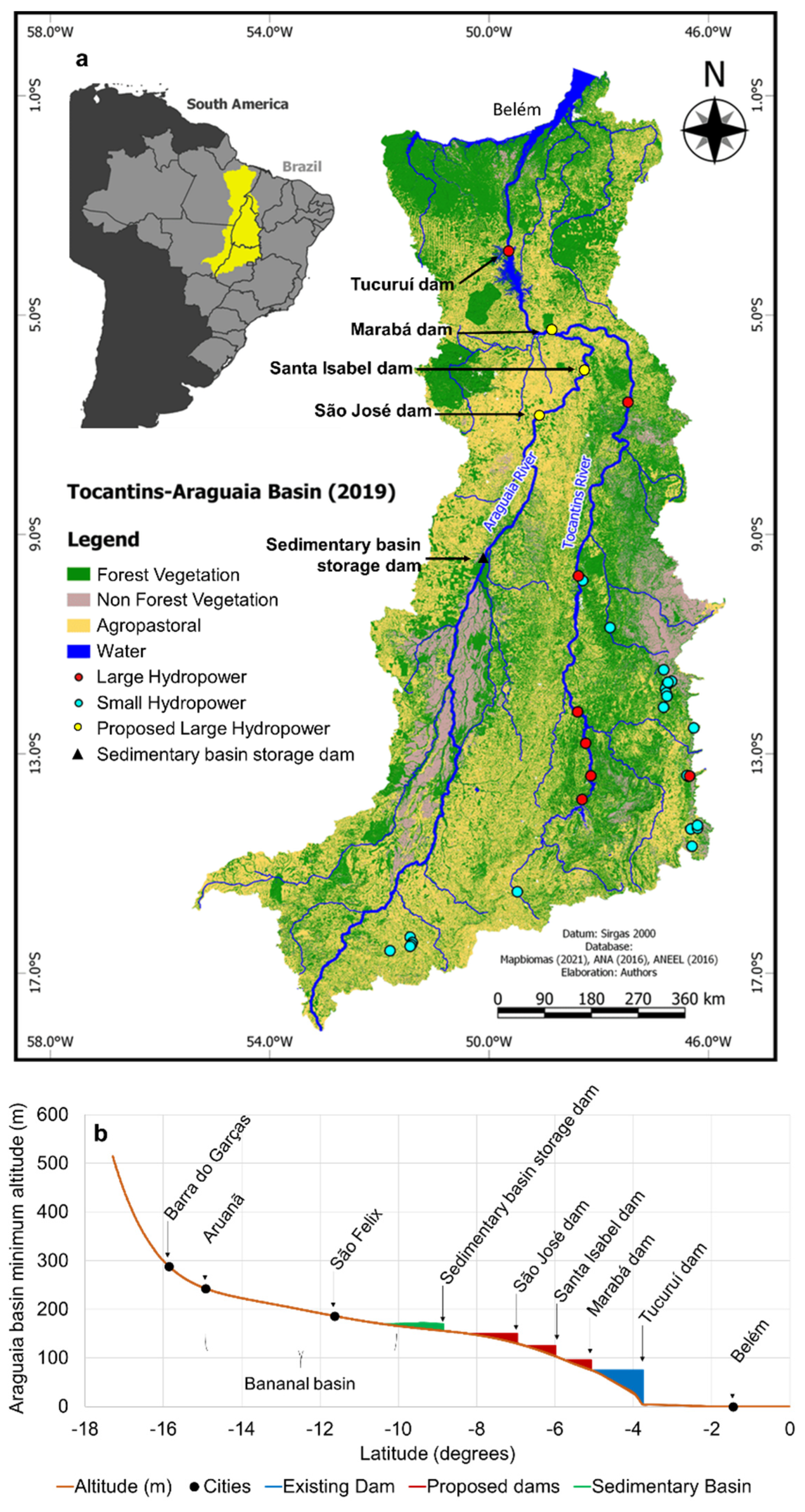
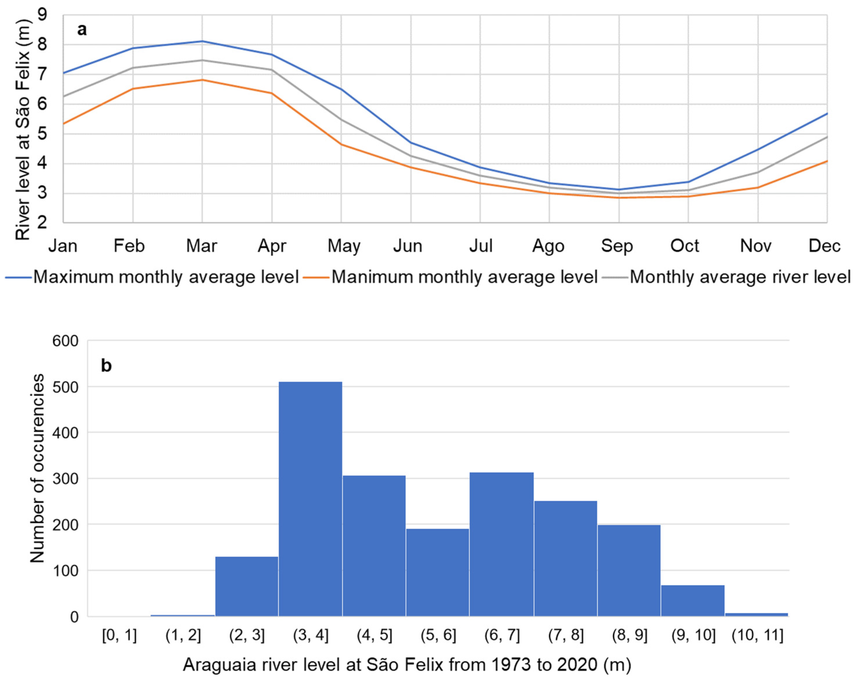
| 3 | Hydrological data | Hydrological data (river level and river flow) at different points in the Araguaia basin. These points are shown in [38]. | [38] |
| Basin river flow analysis | Data on Araguaia River flow at different points [38] were used to estimate the impact of the sedimentary basin on the river flow downstream from the Bananal basin. | [39] | |
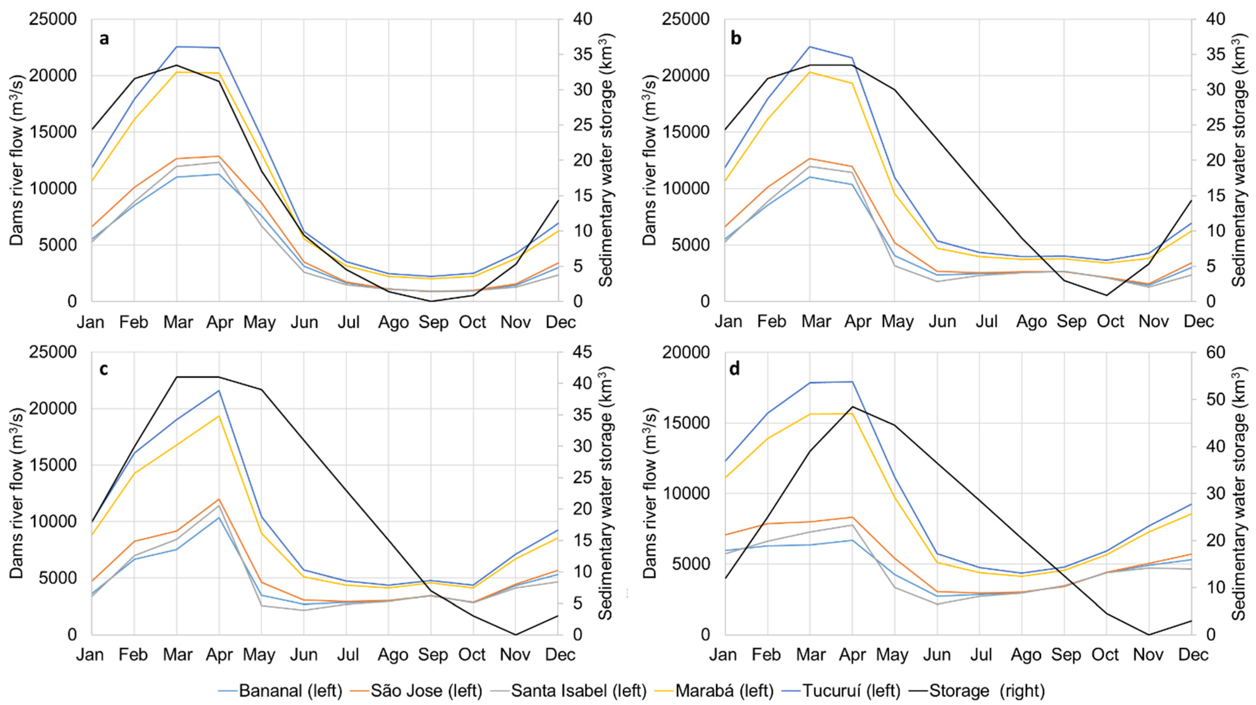
| Dams in cascade | Data on existing dams downstream from the Bananal basin is used to estimate the overall gain in hydropower that results from the proposed use of the Bananal basin for water and energy storage. | [40] |

| Soil Particle Size Classes | AWC at 3 kPa, in cm3/cm3 | AWC at 1500 kPa, in cm3/cm3 | Field Capacity (v%) |
|---|---|---|---|
| Sand | 0.02–0.16 | 0.01–0.06 | 10 |
| Loamy sand | 0.06–0.19 | 0.02–0.09 | 12 |
| Sandy loam | 0.13–0.29 | 0.03–0.16 | 18 |
| Silt loam | 0.26–0.40 | 0.08–0.19 | 31 |
| Silty clay loam | 0.30–0.43 | 0.14–0.28 | 38 |
| Silty clay loam | 0.19–0.32 | 0.09–0.21 | 27 |
| Clay loam | 0.25–0.39 | 0.12–0.28 | 36 |
| Silty clay | 0.33–0.44 | 0.19–0.31 | 41 |
| Clay | 0.33–0.47 | 0.21–0.34 | 42 |
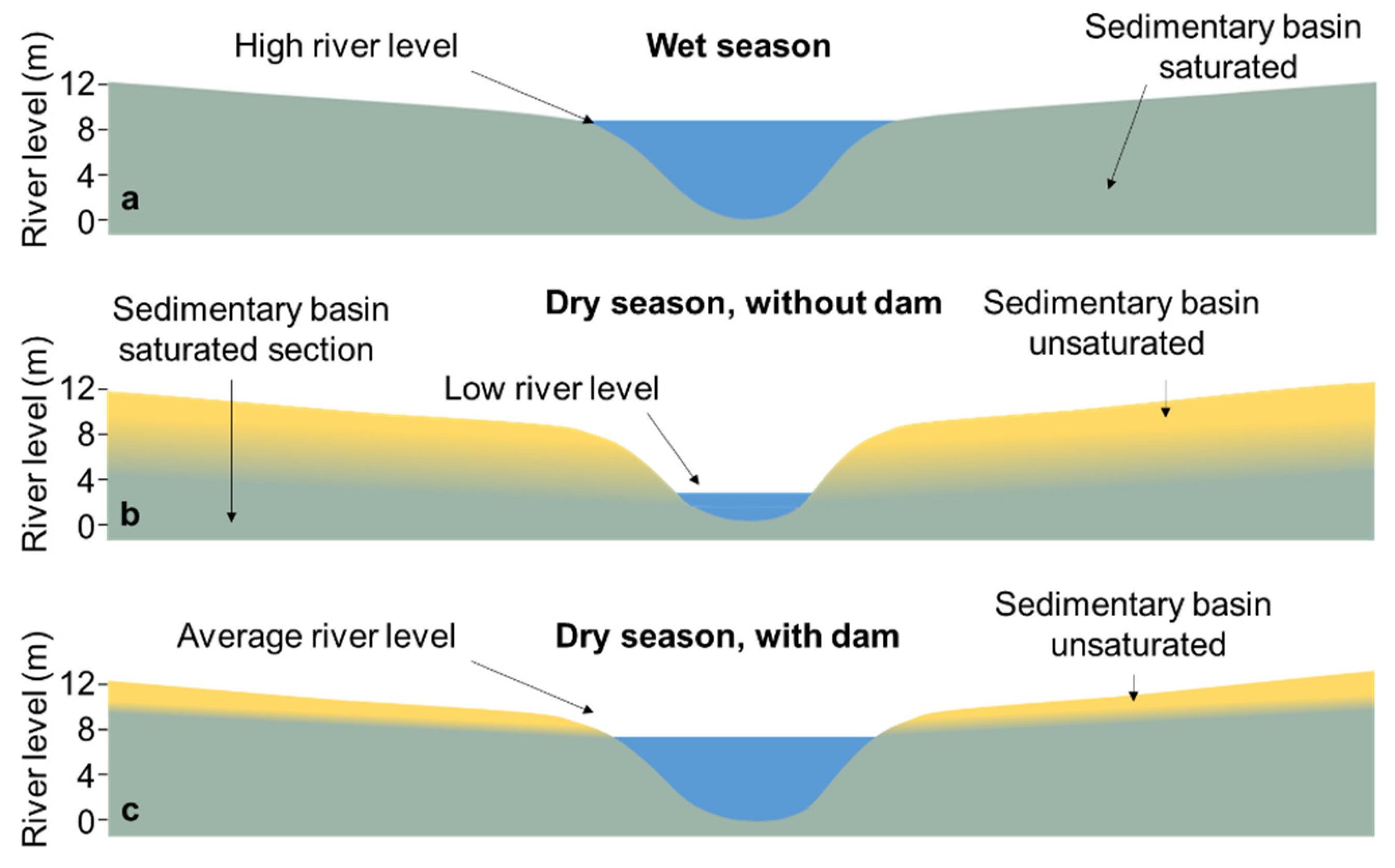
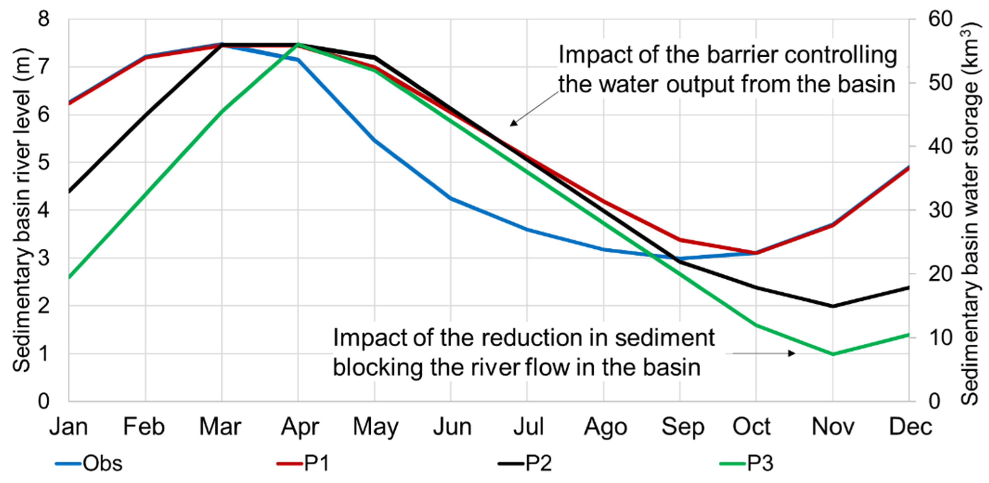
Impact of River Level on Basin Water Storage
3. Results
3.1. Bananal Basin Water Storage Capacity
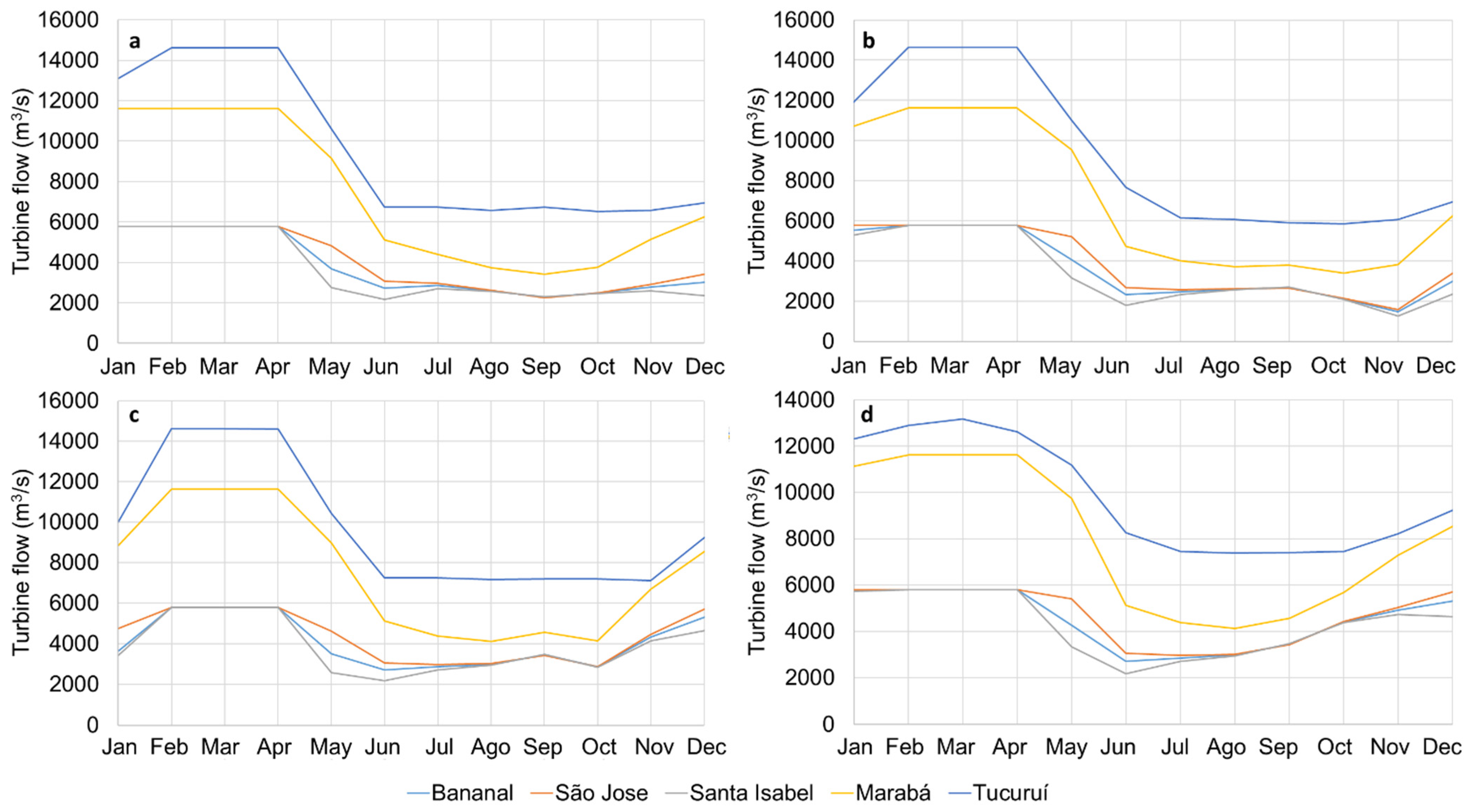
3.2. Hydropower Generation Gains
3.3. Energy Storage Costs
4. Discussion
5. Conclusions
Author Contributions
Funding
Conflicts of Interest
References
- Allen, P.; Allen, J. Basin Analysis; Blackwell Publishing: Hoboken, NJ, USA, 2005; Chapter 1; pp. 13–18. [Google Scholar]
- Choudhury, M.; Sharma, A.; Singh, P.; Kumar, D. 17—Impact of Climate Change on Wetlands, Concerning Son Beel, the Largest Wetland of North East, India; Singh, S., Singh, P., Rangabhashiyam, S., Srivastava, K.K.B.T., Eds.; Elsevier: Amsterdam, The Netherlands, 2021; pp. 393–414. ISBN 978-0-12-822928-6. [Google Scholar]
- Bradley, C. Wetlands, 3rd ed.; Mitsch, W.J., Gosselink, J.G., Eds.; John Wiley & Sons: New York, NY, USA, 2000; p. 920. ISBN 0 471 29232 X. [Google Scholar]
- Kvét, J.; Westlake, D.F.; Dykyjová, D.; Marshall, E.J.P.; Ondok, J.P. Primary production in wetlands. In The Production Ecology of Wetlands: The IBP Synthesis; Szczepanski, A., Westlake, D.F., Kvet, J., Eds.; Cambridge University Press: Cambridge, UK, 1999; pp. 78–168. ISBN 9780521228220. [Google Scholar]
- Duffy, W.G.; Kahara, S.N. Wetland ecosystem services in California’s Central Valley and implications for the Wetland Reserve Program. Ecol. Appl. 2011, 21, S128–S134. [Google Scholar] [CrossRef]
- Hunt, J.; Byers, E.; Riahi, K.; Langan, S. Comparison between seasonal pumped-storage and conventional reservoir dams from the water, energy and land nexus perspective. Energy Convers. Manag. 2018, 166, 385–401. [Google Scholar] [CrossRef]
- Hunt, J.D.; Freitas, M.A.V.D.; Pereira Junior, A.O. A review of seasonal pumped-storage combined with dams in cascade in Brazil. Renew. Sustain. Energy Rev. 2017, 70, 385–398. [Google Scholar] [CrossRef]
- Hunt, J.D.; Zakeri, B.; Lopes, R.; Barbosa, P.S.F.; Nascimento, A.; de Castro, N.J.; Brandão, R.; Schneider, P.S.; Wada, Y. Existing and new arrangements of pumped-hydro storage plants. Renew. Sustain. Energy Rev. 2020, 129, 109914. [Google Scholar] [CrossRef]
- Hunt, J.; Byers, E.; Wada, Y.; Parkinson, S.; Gernaat, D.; Langan, S.; Vuuren, D.; Riahi, K. Global resource potential of seasonal pumped-storage for energy and water storage. Nat. Commun. 2020, 11, 947. [Google Scholar] [CrossRef] [Green Version]
- Hunt, J.D.; Zakeri, B.; Falchetta, G.; Nascimento, A.; Wada, Y.; Riahi, K. Mountain Gravity Energy Storage: A new solution for closing the gap between existing short- and long-term storage technologies. Energy 2020, 190, 116419. [Google Scholar] [CrossRef]
- Hunt, J.D.; Guillot, V.; de Freitas, M.A.V.; Solari, R.S.E. Energy crop storage: An alternative to resolve the problem of unpredictable hydropower generation in Brazil. Energy 2016, 101, 91–99. [Google Scholar] [CrossRef]
- Hunt, J.D.; Freitas, M.A.V.; Pereira Junior, A.O. Enhanced-Pumped-Storage: Combining pumped-storage in a yearly storage cycle with dams in cascade in Brazil. Energy 2014, 78, 513–523. [Google Scholar] [CrossRef]
- Hunt, J.D.; Falchetta, G.; Parkinson, S.; Vinca, A.; Zakeri, B.; Byers, E.; Jurasz, J.; Quaranta, E.; Grenier, E.; Pereira, A.O., Jr.; et al. Hydropower and seasonal pumped hydropower storage in the Indus basin:pros and cons. J. Energy Storage 2021, 41, 102916. [Google Scholar] [CrossRef]
- IMMAP and USAID Pakistan—Rivers Flow Forecast. Available online: https://reliefweb.int/sites/reliefweb.int/files/resources/Pakistan%20Rivers%20Flow%2026%20august.pdf (accessed on 15 November 2021).
- IMMAP and USAID Pakistan—Reservoirs & Rivers Flow Map. Available online: https://reliefweb.int/sites/reliefweb.int/files/resources/Reservoirs%20and%20Rivers%20Flow%20Map10th%20october.pdf (accessed on 15 November 2021).
- Ghazanfar, A.; Hasson, S.; Khan, A. Climate Change: Implications and Adaptation of Water Resources in Pakistan; Global Change Impact Studies Centre: Islamabad, Pakistan, 2009. [Google Scholar]
- Gleeson, T.; Smith, L.; Moosdorf, N.; Hartmann, J.; Dürr, H.H.; Manning, A.H.; Van Beek, L.P.H.; Jellinek, A.M. Mapping permeability over the surface of the Earth. Geophys. Res. Lett. 2011, 38, L02401. [Google Scholar] [CrossRef] [Green Version]
- Aviso+ Satellite Altimetry Data River Monitoring. Available online: https://www.aviso.altimetry.fr/en/applications/hydrology-and-land/rivers.html (accessed on 20 December 2021).
- Hunt, J.D.; Byers, E.; Prenner, R.; de Freitas, M.A.V. Dams with head increaser effect: Harnessing potential and kinetic power from rivers with large head and flow variation. Energy Convers. Manag. 2018, 157, 549–561. [Google Scholar] [CrossRef]
- Bhatti, A.; Suttinon, P.; Nasu, S. Agriculture water demand management in Pakistan: A review and perspective. Soc. Soc. Manag. Syst. 2009, 9, 1–7. [Google Scholar]
- Araújo, J.; Carneiro, R. Planície do Araguaia, Reconhecimento Geológico-Geofísico; Petrobrás/RENOR: Belém, Brazil, 1977. [Google Scholar]
- Furch, K.; Junk, W. Physicochemical conditions in floodplains. In The Central Amazon Floodplain: Ecology of a Pulsing System Ecological Studies; Junk, W., Ed.; Springer: Berlin/Heidelberg, Germany, 1997; pp. 69–108. [Google Scholar]
- Irion, G.; Nunes, G.M.; Nunes-da-Cunha, C.; de Arruda, E.C.; Santos-Tambelini, M.; Dias, A.P.; Morais, J.O.; Junk, W.J. Araguaia River Floodplain: Size, Age, and Mineral Composition of a Large Tropical Savanna Wetland. Wetlands 2016, 36, 945–956. [Google Scholar] [CrossRef]
- Google. The World’s Most Detailed Globe. Available online: https://www.google.com/earth/ (accessed on 5 November 2021).
- Latrubesse, E.; Stevaux, J. Geomorphology and environmental aspects of the Araguaia fluvial basin, Brazil. Z. Geomorphol. Suppl. 2002, 129, 109–127. [Google Scholar]
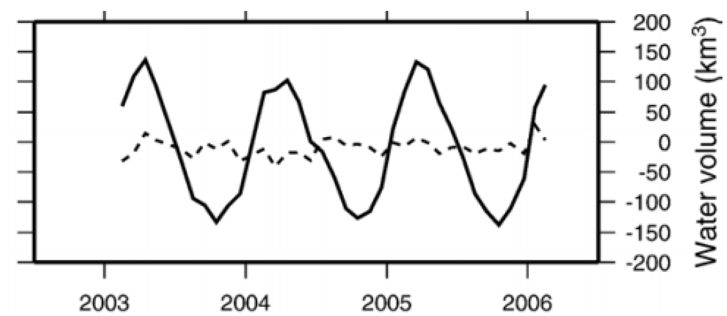
- Ramillien, G.; Bouhours, S.; Lombard, A.; Cazenave, A.; Flechtner, F.; Schmidt, R. Land water storage contribution to sea level from GRACE geoid data over 2003–2006. Glob. Planet. Chang. 2008, 60, 381–392. [Google Scholar] [CrossRef]
- Catolico, A.C.C.; Maestrini, M.; Strauch, J.C.M.; Giusti, F.; Hunt, J. Socioeconomic impacts of large hydroelectric power plants in Brazil: A synthetic control assessment of Estreito hydropower plant. Renew. Sustain. Energy Rev. 2021, 151, 111508. [Google Scholar] [CrossRef]
- Johnson, N.; Burek, P.; Byers, E.; Falchetta, G.; Flörke, M.; Fujimori, S.; Havlik, P.; Hejazi, M.; Hunt, J.; Krey, V.; et al. Integrated solutions for thewater-energy-land nexus: Are global models rising to the challenge? Water 2019, 11, 2223. [Google Scholar] [CrossRef] [Green Version]
- Hunt, J.D.; Leal Filho, W. Land, Water, and Wind Watershed Cycle: A strategic use of water, land and wind for climate change adaptation. Clim. Chang. 2018, 147, 427–439. [Google Scholar] [CrossRef]
- Hunt, J.D.; Nascimento, A.; ten Caten, C.S.; Tomé, F.M.C.; Schneider, P.S.; Thomazoni, A.L.R.; de Castro, N.J.; Brandão, R.; de Freitas, M.A.V.; Martini, J.S.C.; et al. Energy crisis in Brazil: Impact of hydropower reservoir level on the river flow. Energy 2022, 239, 121927. [Google Scholar] [CrossRef]
- Hunt, J.D.; Stilpen, D.; de Freitas, M.A.V. A review of the causes, impacts and solutions for electricity supply crises in Brazil. Renew. Sustain. Energy Rev. 2018, 88, 208–222. [Google Scholar] [CrossRef]
- Hunt, J.D.; Falchetta, G.; Zakeri, B.; Nascimento, A.; Schneider, P.S.; Weber, N.A.B.; Mesquita, A.L.A.; Barbosa, P.S.F.; de Castro, N.J. Hydropower impact on the river flow of a humid regional climate. Clim. Chang. 2020, 163, 379–393. [Google Scholar] [CrossRef]
- Information. Available online: https://csidotinfo.wordpress.com/data/srtm-90m-digital-elevation-database-v4-1/ (accessed on 11 May 2021).
- Geological Survey of Brazil Disaster Prevention. Available online: https://geoportal.cprm.gov.br/desastres/ (accessed on 2 September 2021).
- Koops, D. Know Your Water Holding Capacity. Available online: https://www.cropquest.com/know-your-water-holding-capacity/# (accessed on 17 October 2021).
- Gillreath-Brown, A. Looking Outward from the Village: The Contingencies of Soil Moisture on the Prehistoric Farmed Landscape Near Goodman Point Pueblo. Master’s Thesis, University of North Texas, Denton, TX, USA, 2016. [Google Scholar]
- Slapgard, J. Cost Base for Hydropower Plants; Norwegian University of Science and Technology: Oslo, Norway, 2012. [Google Scholar]
- Brazilian National Water Agency Hidroweb. Available online: http://www.snirh.gov.br/hidroweb/publico/mapa_hidroweb.jsf (accessed on 14 December 2021).
- De Araujo Gomes, R.; Lima Fernandes, L. Hydrological characterization of the Araguaia River through reference flows. Appl. Water Sci. 2017, 7, 4605–4614. [Google Scholar] [CrossRef] [Green Version]
- ONS. Dams Database for 600 Dams in Operation, under Construction and Planning Stages—Available up on Request to ONS and as Supplementary Information in This Paper; A Report; ONS: Rio de Janeiro, Brazil, 2013. [Google Scholar]
- Israelsen, O.; West, F. Water holding capacity of irrigated soils. Utah State Agric. Exp. Stn. Bull. 1922, 183, 1–24. [Google Scholar]
- Veihmeyer, F.; Hendrickson, A. The moisture equivalent as a measure of the field capacity of soils. Soil Sci. 1931, 32, 181–194. [Google Scholar] [CrossRef]
- Lezzaik, K.; Milewski, A. A quantitative assessment of groundwater resources in the Middle East and North Africa region. Hydrogeol. J. 2018, 26, 251–266. [Google Scholar] [CrossRef]
- Pelicice, F.M.; Agostinho, A.A.; Akama, A.; Andrade Filho, J.D.; Azevedo-Santos, V.M.; Barbosa, M.V.M.; Bini, L.M.; Brito, M.F.G.; dos Anjos Candeiro, C.R.; Caramaschi, É.P.; et al. Large-scale Degradation of the Tocantins-Araguaia River Basin. Environ. Manag. 2021, 68, 445–452. [Google Scholar] [CrossRef]
- De Andrade Furtado, G.C.; Amarante Mesquita, A.L.; Morabito, A.; Hendrick, P.; Hunt, J.D. Using hydropower waterway locks for energy storage and renewable energies integration. Appl. Energy 2020, 275, 115361. [Google Scholar] [CrossRef]
- Hunt, J.D.; Zakeri, B.; de Barros, A.G.; Filho, W.L.; Marques, A.D.; Barbosa, P.S.F.; Schneider, P.S.; Farenzena, M. Buoyancy Energy Storage Technology: An energy storage solution for islands, coastal regions, offshore wind power and hydrogen compression. J. Energy Storage 2021, 40, 102746. [Google Scholar] [CrossRef]
- Leal Filho, W.; Hunt, J.; Lingos, A.; Platje, J.; Vieira, L.W.; Will, M.; Gavriletea, M.D. The Unsustainable Use of Sand: Reporting on a Global Problem. Sustainability 2021, 13, 3356. [Google Scholar] [CrossRef]
- Canales, F.A.; Beluco, A.; Mendes, C.A.B. A comparative study of a wind hydro hybrid system with water storage capacity: Conventional reservoir or pumped storage plant? J. Energy Storage 2015, 4, 96–105. [Google Scholar] [CrossRef]
- Salimi, A.A.; Karimi, A.; Noorizadeh, Y. Simultaneous operation of wind and pumped storage hydropower plants in a linearized security-constrained unit commitment model for high wind energy penetration. J. Energy Storage 2019, 22, 318–330. [Google Scholar] [CrossRef]
- Al-Masri, H.M.K.; Magableh, S.K.; Abuelrub, A.; Alzaareer, K. Realistic coordination and sizing of a solar array combined with pumped hydro storage system. J. Energy Storage 2021, 41, 102915. [Google Scholar] [CrossRef]
- Kusakana, K. Optimal operation scheduling of grid-connected PV with ground pumped hydro storage system for cost reduction in small farming activities. J. Energy Storage 2018, 16, 133–138. [Google Scholar] [CrossRef]
- Olatunde, O.; Hassan, M.Y.; Abdullah, M.P.; Rahman, H.A. Hybrid photovoltaic/small-hydropower microgrid in smart distribution network with grid isolated electric vehicle charging system. J. Energy Storage 2020, 31, 101673. [Google Scholar] [CrossRef]
- IEA. Hydropower Has a Crucial Role in Accelerating Clean Energy Transitions to Achieve Countries’ Climate Ambitions Securely. Available online: https://www.iea.org/news/hydropower-has-a-crucial-role-in-accelerating-clean-energy-transitions-to-achieve-countries-climate-ambitions-securely (accessed on 2 October 2021).


| Dam | Tucuruí | Marabá | Santa Isabel | São José | Bananal |
|---|---|---|---|---|---|
| Reservoir type | Storage | Run-of-the-river | Run-of-the-river | Run-of-the-river | Storage |
| Turbine type | Francis | Kaplan | Kaplan | Kaplan | Moveable HEPP |
| Installed capacity (MW) | 8535 | 2160 | 1087 | 1087 | 815 |
| Turbined flow (m3/s) | 14,626 | 11,616 | 5784 | 5784 | 5784 |
| Maximum flooded area (km2) | 3024 | 1115 | 240 | 220 | 0.0 |
| Minimum flooded area (km2) | 761 | - | - | - | 0.0 |
| Maximum volume (km3) | 50.3 | 5.58 | 1.85 | 1.60 | 33.5 |
| Minimum volume (km3) | 11.3 | - | - | - | - |
| Useful volume (km3) | 39.0 | - | - | - | Obs: 33.5/P1: 33.5/P2: 41/P3: 49 |
| Volume used yearly (km3) | 31.2 | - | - | - | Obs: 33.5/P1: 33.5/P2: 41/P3: 49 |
| Maximum level (m) | 74 | 96 | 125 | 150 | 170 |
| Minimum level (m) | 51.6 | - | - | - | Obs: 165.5/P1: 165.5/P2: 164.5/P3: 163.5 |
| Downstream level (m) | 8.5 | 75 | 104 | 130 | 154 |
| Generation head (m) | 65.5 | 21 | 21 | 20 | 16 |
| Yearly river flow (km3) | 310 | 279 | 147 | 169 | 140 |
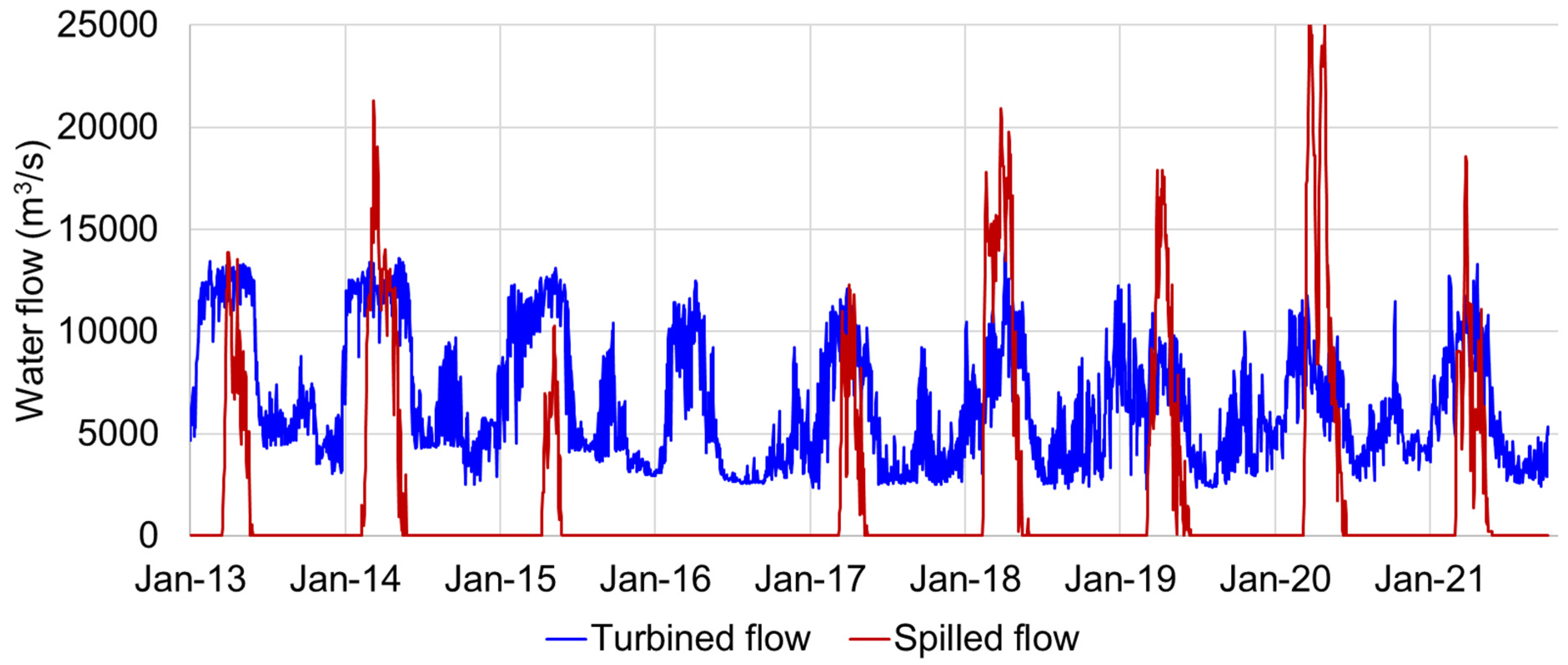
| Spillage in scenario Obs (km3) | 32 | 61 | 44 | 58 | 40 |
| Spillage in scenario P1 (km3) | 27 | 55 | 39 | 46 | 33 |
| Spillage in scenario P2 (km3) | 20 | 41 | 25 | 32 | 19 |
| Spillage in scenario P3 (km3) | 0 | 27 | 11 | 21 | 6 |
| Additional generation in scenario P1 (TWh) * | 0.8 | 0.3 | 0.2 | 0.6 | 0.3 |
| Additional generation in scenario P2 (TWh) * | 1.9 | 1.0 | 1.0 | 1.3 | 0.8 |
| Additional generation in scenario P3 (TWh) * | 5.1 | 1.8 | 1.7 | 1.8 | 1.4 |
| Total yearly generation in scenario Obs (TWh) | 44.7 | 11.2 | 5.3 | 5.4 | 3.9 |
| Total yearly generation in scenario P1 (TWh) | 45.5 | 11.5 | 5.6 | 6.0 | 4.2 |
| Total yearly generation in scenario P2 (TWh) | 46.5 | 12.3 | 6.3 | 6.7 | 4.8 |
| Total yearly generation in scenario P3 (TWh) | 49.8 | 13.0 | 7.0 | 7.2 | 5.3 |
| Capacity factor in scenario Obs (%) | 60 | 59 | 56 | 57 | 55 |
| Capacity factor in scenario P1 (%) | 61 | 61 | 58 | 63 | 59 |
| Capacity factor in scenario P2 (%) | 62 | 65 | 66 | 71 | 67 |
| Capacity factor in scenario P3 (%) | 67 | 69 | 73 | 76 | 74 |
| Description | P1 | P2 | P3 |
|---|---|---|---|
| Dam investment cost (billion USD) [37] | 2.0 | 2.0 | 2.0 |
| Canal investment cost (billion USD) [37] | - | 1.0 | 2.0 |
| Canal length (km) | - | 160 | 160 |
| Canal depth (m) | - | 5 | 5 |
| Total energy storage cost (billion USD) | 2.0 | 3.0 | 4.0 |
| Energy storage capacity (TWh) | 2.3 | 6.0 | 11.7 |
| Energy storage cost in CAPEX (USD/kWh) | 0.874 | 0.498 | 0.341 |
| Lithium storage cost in CAPEX (USD/kWh) [46] | 150 | ||
| Energy storage cost comparison (sedimentary hydro storage vs. lithium storage) | 172 | 301 | 440 |
| Sedimentary Basins | Beni, Mamoré, Guaporé & Madeira | Paraguay |
|---|---|---|
| Basin area (km2) | 87,500 | 63,000 |
| Level variation (m) | 5 to 20 | 2 to 3 |
| Water storage (km3) * | 66 | 19 |
| Average generation head (m) ** | 72 | 52.8 |
| Energy storage (TWh) | 11.6 | 2.5 |
Publisher’s Note: MDPI stays neutral with regard to jurisdictional claims in published maps and institutional affiliations. |
© 2022 by the authors. Licensee MDPI, Basel, Switzerland. This article is an open access article distributed under the terms and conditions of the Creative Commons Attribution (CC BY) license (https://creativecommons.org/licenses/by/4.0/).
Share and Cite
Hunt, J.D.; Nascimento, A.; Guzman, O.J.R.; Furtado, G.C.d.A.; ten Caten, C.S.; Tomé, F.M.C.; Leal Filho, W.; Đurin, B.; Lopes, M.; Wada, Y. Sedimentary Basin Water and Energy Storage: A Low Environmental Impact Option for the Bananal Basin. Energies 2022, 15, 4498. https://doi.org/10.3390/en15124498
Hunt JD, Nascimento A, Guzman OJR, Furtado GCdA, ten Caten CS, Tomé FMC, Leal Filho W, Đurin B, Lopes M, Wada Y. Sedimentary Basin Water and Energy Storage: A Low Environmental Impact Option for the Bananal Basin. Energies. 2022; 15(12):4498. https://doi.org/10.3390/en15124498
Chicago/Turabian StyleHunt, Julian David, Andreas Nascimento, Oldrich Joel Romero Guzman, Gilton Carlos de Andrade Furtado, Carla Schwengber ten Caten, Fernanda Munari Caputo Tomé, Walter Leal Filho, Bojan Đurin, Maurício Lopes, and Yoshihide Wada. 2022. "Sedimentary Basin Water and Energy Storage: A Low Environmental Impact Option for the Bananal Basin" Energies 15, no. 12: 4498. https://doi.org/10.3390/en15124498
APA StyleHunt, J. D., Nascimento, A., Guzman, O. J. R., Furtado, G. C. d. A., ten Caten, C. S., Tomé, F. M. C., Leal Filho, W., Đurin, B., Lopes, M., & Wada, Y. (2022). Sedimentary Basin Water and Energy Storage: A Low Environmental Impact Option for the Bananal Basin. Energies, 15(12), 4498. https://doi.org/10.3390/en15124498