Abstract
Agriculture residue is a promising resource of energy. It can be seen as a source of power production. In India, there is a huge amount of biomass available, but it cannot be used in proper ways, and with the help of GIS it can be customised. In the present paper, it is estimated that biomass reserves are available for power generation. The biomass produced by the surplus agricultural crops is reflected as a source of fuel for electricity generation. The data taken by satellite are useful for assessment of the areas with the help of satellite images taken in high resolution, which increases the preciseness of estimation. An agriculture cropland map with agricultural statistics has been analyzed in GIS to discover the agricultural straw potential for bioenergy generation. Due to unawareness about the benefits and uses of GIS, the modern farming sector bears a loss of huge bioenergy potential every year. To overcome the above mentioned challenges, the agricultural system needs a major shift from conventional farming to smart farming practices with the help of GIS. Agricultural waste is the best source for bioenergy production, and it can be used as biomass for meeting renewable energy goals in the country.
1. Introduction
GIS has been successful and is well known in several fields of study, such as resource conservation, ecosystem evaluation, analysis of habitats, planning of land use sites, environmental disaster monitoring, etc. Because of some distinct benefits of geospatial technologies across modern techniques (e.g., data collection, survey), the use of spatial instruments is gaining popularity. Most satellite data are available free of charge (e.g., Landsat imagery), and are easily acessible. GIS can prove to be a decisive tool for assessing the status and planning of the area’s renewable energy assets, and the cost-effective use of such resources. For biomass energy studies, a broader application of the geo-spatial technique is most popular. Agricultural leftovers such as rice straw must be accepted as a potential feedstock for bioenergy production. Rice is primarily cultivated in various portions of India, providing a huge quantity of grain. It is estimated that India is producing 22 million tons of rice straw with an annual surplus [1]; large amounts of straw are left in the waste field or burned in several parts of the country. There is a greater concern in two cases: (i) the release of methane while the left out straw remained ungrabbed and was permitted to decompose in the field and (ii) the discharge of atmospheric contaminants (carbon monoxide etc.) when burned in the open. Therefore, in addition to its potential for renewable energy production, straw management is also relevant from an environmental point of view. Pitiable power sources categorized by common power cutting and voltage fluctuation are common features of rural India, while more than two-thirds of the people live in rural areas and it is estimated that approximately 78 million people rely on kerosene lamps for light in India [2]. Due to the lack of reliable, accessible electricity sources, the Indian government needs to start a rural national level program, with traditional grid-connected power supplies in several remote rural communities where it is almost impossible to access electricity. Thus, power generation utilizing a source of energy available locally seems to be a realistic choice in such areas. Insufficient electricity supply can be the main obstacle in development. Electricity shortages affect not only important household operations, but also industry, agriculture, health, and education systems. Due to poor electricity supply, small rural businesses are also harmfully affected. When liquid fuel or energy is generated from renewable sources, ignition gases do not contribute to fossil fuel CO2 discharges. Therefore, the usage of agricultural waste for energy generation has positive effects on climate change. The present review takes account of the appropriate potential source of agricultural wastes for energy production. Biomass feedstock (e.g., agricultural residues) may contribute to meeting national and regional energy demands if used for clean energy production. Biomass, which is known as the carbon-neutral source of renewable electricity, has several advantages: it could be stored and used for various purposes if required, depending on the needs, conversion technology and economic viability in terms of water, electricity saving and biogas processing. One of the drawbacks is the cost of lorry transport and lower transformation efficiency than fossil fuels. Technologies for transforming biomass are proven to produce electricity and are commercially accessible. Biomass is commonly used in rural areas for old-style cooking purposes. Approximately 64% of the rural population makes use of biomass as a cooking fuel [3]. On another hand, it shows that agriculture residue is available in abundance and does not create any competetion with food to produce clean and renewable energy when used under suitable biomass conversion processes. Oil geopolitics, limited fossil fuel choices and ecological warnings have pushed India to seek clean energy options. Wind, solar, biomass, and small hydropower have been recognized as India’s leading fields of development in renewable energy. The country’s estimated grid-connected power potential consists of more than 87 GW of biomass, wind and small hydro. Solar varies from 20 MW/km2 to 30 MW/km2 [4]. The Ministry of New and Renewable Energy (MNRE)acknowledges the promise of the bioenergy generation. India has initiated many projects on biomass, promoting achievement. Estimates show that by 2031–2032, capacity generating power will have to be expanded to almost 800 GW from the current capacity of around 183 GW to meet the basic energy needs of its plant citizens, including all captive plants [5]. The demand for electricity has surpassed availability, thereby raising living standards. The restriction of the electricity supply has forced virtually all businesses, residential, institutional or industrial, to depend on furnace oil or diesel. The shortage of adequate rural energy has led to the use of kerosene on a large scale. Biomass assets remain comparatively uniform in terms of accessibility in India in relation to other renewable sources. A high-quality crop residue is produced in India and can be found via GIS. Figure 1 shows the methods to apply in GIS for estimating bioenergy potential.
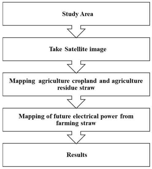
Figure 1.
Methods to apply in GIS for estimating bioenergy potential.
2. GIS-Based Bioenergy Potential of Agro-Residues
The supply chain for bioenergy can be divided into three principal spatially added features, as shown in Figure 2. GIS interference in planning for bioenergy is required because: (i) varied variations of agro-residues is used for strength feedstocks, therefore preserving their spatiotemporal file about chemical and physical properties, connectivity and storage is more significant. GIS offers several benefits which can be accessed later for the efficient raw material collection-cum-management and cost-benefit analysis for bioenergy production [6,7]. Periodically, it is also necessary to update the biomass inventory to assess the potential for future feedstock supply; (ii) confirming the continued supply of feedstock is critical to the power plants. Earlier information on some variations in the source of feedstock would permit the consumer to make the essential arrangements for another supply of feedstock during the lean supply period and can be specified using GIS [8]; (iii) the environmental requirements of residue and economy, harvest constraints, infrastructure, competing for residue use, local socio-political dynamics, civil land use and industrial logistics facilities may also be evaluated with GIS’s geographical supply of agro-residue and effective strategic preparation for the time- and cost-effective selection and storage of residues may be performed (Figure 3) [7,9,10,11].
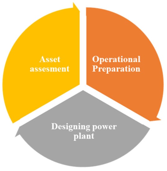
Figure 2.
Supply chain for Bioenergy.
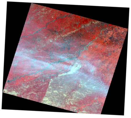
Figure 3.
GIS image of study area (red color indicating healthier vegetation).
The supply of a biomass chain that affects the final cost of bioenergy contains biomass producers, transporter and distribution items, developers and operators of energy production facilities, government and utility companies and end-users [12]. A spatial network allows us to plan for bioenergy potential by exchanging costs, logistics and personnel in a common framework [9]. Increasing resistance to manufacturing zones, raw materials often need spatially specific logistical preparation [13]. The transport price may be high depending on the distance and method of transport (land, rail and waterway), the quality of the feedstock and the state of the road transport.
Optimizing the transportation link can decrease the price of transport [11,14,15,16]. Examples include the network predictor addition of ArcGIS software, which can be used to deliver feedstock/biomass, a source-to-consumer place for transportation pathways. This enables one to conduct different spatial network-based applications such as shortest path recognition, nearest station, service area and destination origin search [14]. Further, transferring solid biomass decreases the costs of CO2 production afterwards, except for limited distances by enabling larger volumes to be transported [7]. Logistic limits need management consideration in choosing the best part of the biomass selection and power plant site, where many considerations come into play. When choosing optimal biomass collection, areas that should be considered include current agricultural and geographical area, and the covering locations of distribution and the consumer [9]. The position should be appropriate for the better preparation of power transmission lines by transport road and should have close service points [17]. Additionally, the plant should work into appropriate residential areas and natural assets to reduce potential negative impacts of plant activity and waste management. A GIS method has been developed for assessing techno-economic prospects of biomass for generating power and concluded the documentation for well-organized transport network and best areas of aggregation of biomass [9]. A designed GIS organizational price analysis was developed for biomass manufacturing units by examining profit investment in organization and biomass distribution facilities [13]. GIS-based choice of biomass power plants can be carried out using two ways: (i) optimum assessment of suitability, and (ii) as per Shi et al., [18] appropriate assessment enables users to determine the appropriate sites for the power plant among numerous candidate sites, created on the limitations and then helpful requirements identified by the employee.
In comparison, the optimal analysis takes into account the connection between biomass and power plants to search for the best positions of the power plant at the lowest transport cost. The optimization of the relationship between the location of the biomass to power plants was accomplished either by modeling the place-allocation or by modeling the supply region. Using the optimal evaluation method, [18] potential locations were found for the biomass power plants in Guangdong Province; transport costs is a key factor in the growth of bioenergy plants. Logistic preparation for the selection of biomass can also be affected by the landholding type. In India and China, for example, agro-residue biomass production from agriculture can be difficult compared with Western countries due to small farm land-holdings by the farmers [19]. The collectors do need to contend with a greater number of farmers with coordinated procurement, processing and distribution logistics for the same collection range [19]. Biomass receiving stations distributed in a long supply chain (satellite storage) as stated by [19] must be configured for the lowest biomass distribution costs. A large area for the collection of biomass results in improved power plant efficiency, rendering the power plant economically stable, but also raises the costs of delivering biomass to the power plant. Accordingly, research [10] has indicated that it is unfeasible to maximize the location and size of any potential plant in the huge-scale study with a broad topographical biomass supply region (e.g., nation, area). Nevertheless, the best choice is to perform the same region for the set entire territory and the scale of this area is calculated in such a way as to meet the minimum installed capacity of the individual plant [10]. Egbendewe-Mondzozo et al. [20] suggested a spatial bio-economic method, an application of the biophysical GIS regional economic statistical optimization process, to estimate the production of biomass from crop residues and cellulosic crops. This portion of GIS provides criteria for transportation and the bio-economic model. Ultimately, the model will predict how to react to developments in genetic and biological regulation, market pricing and government policies through biomass supply and environmental advice. Similarly, in Punjab, India, [21] a GIS concept for a decentralized biomass power station has been developed, with the layout being based on agro-residues at the development block stage, which could be beneficial in determining optimum power plant position of minimal range processing and feedstock handling costs. GIS systems have been considered suitable for mall-scale energy design at the village level [16,22]. Examples of GIS implementations in bioenergy preparation for agro-residues are shown in Table 1 below.

Table 1.
GIS implementations in bioenergy.
Table 1.
GIS implementations in bioenergy.
| Fields | Remark | References |
|---|---|---|
| Crop residue potential | Sustainable crop residue capacity evaluation focused on GIS in five European regions | [23] |
| Agro-forestry residue | Assessment of the production of biomass, techno-economic sustainability and environmental implications of the use of GIS and RETScreen agro-forestry residues | [24] |
| Biomass availability and transport logistics | GIS-based calculation of biomass for agro-forestry and shipping logistics | [25] |
| Agro-forestry biomass | GIS-based approach for the estimation of agro-forestry biomass technological capacity in Portugal | [26] |
| Biomass transport | GIS software for maximizing biomass distribution | [27] |
| Power plant | Studying the geospatial linkage between rice farms and GIS Power plant | [28] |
3. GIS Analysis of Biomass as Energy Resources
Biomass resources are spread widely over large areas and the availability of spatiotemporal services often varies. Conventional methods such as surveys and secondary data analysis are not sufficient to accurately estimate the potential of bioresource, especially when analyzed at the regional or nationwide level. Nevertheless, the uses of spatial resources such as GIS may address this limitation. Several works of literature have documented the uses of GIS in the assessment of biomass energy resources. Biomass provides for about 75 per cent of India’s rural energy needs. According to Ramachandra et al. [29], in order to increase cost-efficiency and productivity, efficient management of these tools allows for effective and prompt judgments. Spatial decision support systems (SDSS) require the support of strategic management processes, taking into account spatial and temporal variables. The SDSS is described as a computerized multimedia framework which collects data from a wide data set source, analyzes the data collected and then presents it in a manner that the decision-maker can interpret to provide the accurate information necessary to make timely decisions. The researchers have suggested a biomass energy decision support system potential assessment (BEPA) to help planners prepare and sustainably accomplish bio resources for regional implementation. Fiorese and Guariso [30] proposed a GIS model approach to the optimization of energy products from dedicated arboreal and the herbaceous crops, taking into account native environmental conditions such as natural heritage, climate, geomorphology, and land uses pattern trends in Northern Italy’s Emilia-Romagna region. Thomas et al. [31] presented a GIS-based analysis of England’s potential for biomass energy spatial supply and demand relationships of Miscanthus: there was 2,521,996 ha of viable land, 1,998,435 ha was within 25 km of the feedstock’s potential end-use identified, and 2,409,541 ha was within 40 km. Potential generations reach the UK’s target of 259 pJ for biomass generation in 2020, depending on the radius used. Zhang et al. [32] emphasized the importance of the location decision for the woody biomass feedstock due to the dispersed nature of biomass and the substantial transport cost. The researchers used the two-stage approach to recognize the best location for the development of biofuels based on several attributes. GIS was used in stage I to classify the locations of feasible biofuel facilities. The solution was using district divisions, allocation dependent on regions of the population census, population census, distribution of cities and villages, and networks of rail and state/federal road transport. The chosen place was selected in stage II using a total cost approach of transportation. The technique is used for the biofuel production plant in the Upper Michigan Peninsula. The village of L’anse in Baraga County is considered to be in the best position possible for biofuel development.
Also, the city of Ishpeming arose as another feasible place for the manufacturing facility by implementing sensitivity analysis dependent on a restricted supply of feedstock. A spatial method was used for the regional study of the potential for biomass energy, and assessment of biomass cost at the power generation plant site with regard to distance of transportation, transport costs and the power plant size in Croatia, which took materials such as wheat straw, maize stove and forestry residues as feedstock [33]. We also introduced a technique for assessing a biomass high-level price that the power plant should pay to external suppliers.
Using GIS, Fernandes et al., 2010, [34] evaluated the capacity for energy production and uses of forest and agricultural biomass residues in Marvão, an area in Portugal. It was observed that Marvão has a possible annual biomass residue of approximately 10,600 tons, equivalent to approximately 106,000 GJ per year. Besides the district heating organization of a hotel in Marvão, the village is used as a case study to demonstrate the potential and demand for biomass energy used in Marvão. In this case study, it was observed that the conversion of a biomass-based system of the current fossil fuel heating system provides local investors with economic and environmental benefits. Jiang et al. [35] reported that accurate estimation of the production of crop residue biomass is very relevant to the evolution of the bioenergy sector in farming-dominant China. The authors used a GIS-based approach to evaluate the accessibility and distribution of residues from crops in China, considering a number of conservation problems such as energy (total volume, spatial and temporal distribution), environment (cost of transport), atmosphere, and technology. China is expected to generate net annual crop residues of about 505.5 million tons equal to 7.4 EJ per year. Tenerelli et al. [36] suggested that the GIS-based multi-measures method could be used for identifying a range of possibilities for the conversion of perennial energy crops. The system was applied at local area level in the Yorkshire and Humber region in the north of the UK. In the first step, based on particular pedoclimatic and topographic variables, a land capacity model was designed for assessing the ability of different types of perennial energy crops. In the second phase, a land capacity model uncertainty study was carried out to recognize the effect of expectations and uncertainty regarding input data and parameters of the model. In the final stage of the plan, energy crop conversion areas were allocated restrictions on quality requirements, nature conservation priorities, foodstuff production levels and plot efficiency values. The authors found that the land efficiency model and the uncertainty parameter analysis showed that the land that is extra delicate in positions of environmental hazard corresponds to the plot with the lowermost bioenergy potential and maximum model error. In such regions, it would not be feasible to implement an intensive energy crop program. The authors said that ideally, the proposed model will require various scenarios to be evaluated based on political and commercial perspectives (food vs. energy security and preservation of nature) and the priorities of stakeholders, and that those different scenarios may eventually be combined into a decision support system capable of supporting environmental planning while introducing various bioenergy routes. GIS was used by Yoshioka et al. [37] to determine the viability of the use of wood biomass in a mountainous area of Japan. In the next level, the biomass harvesting and transport systems are being planned. Sacchelli et al. [38] argued that a unique decision support system (DSS) is needed to deal with the complexities of the interaction between ecological, economic and political variables when performing environmental assessments. However, in integrating large-scale research and local planning processes, the lack of data transparency is also a drawback. Because of these loopholes, the authors performed GIS-based research to measure their ability summation of woody biomass in the forestry sector on numerous measurement rulers, to recognize the theoretical effect of biomass deduction on forest multi-functionality and to quantify potential trade-offs between forest functions in the context of the growth of the bioenergy chain in a research study of Italy. They found that in several ways, the model is capable of depicting territorial differences and considering the respective effect on the estimation of the availability of biomass. The model can also describe the optimum quantity of residue removal according to priority forest function in different compartments. Zhuang et al. [39] noted that marginal land bioenergy production has several advantages, such as easing the energy crisis, and conservatory gas emissions mitigation. Multi-factor analysis based on GIS is used to classify marginal land for the production of bioenergy in China. The entire area of exploitable peripheral land for large-scale energy plant growth is approximately 43.75 million ha. If 10 per cent of this peripheral land is used entirely to expand the power generation, the manufacture of biofuel would be 13.39 million tons. Nonetheless, its environmental and ecological consequences along with economic and social benefits should be evaluated to achieve a win-win in the outcome. Angelis-Dimakis et al. [40] presented a survey of currently available methods and resources to identify potential and easily available sources of renewable energy such as solar, wind, sea, or geothermal energy that can be exploited. All these natural and site-specific renewable energy tools are spread. Therefore, they need tools to assess the spatial dimension, and in this regard, geostatistical tools can be very useful, as well as remotely sensed spatial knowledge. All of these renewable resources studies involve GIS to process data and show their local effects. Sun et al. [41] in a case study in the province of Fujian, China, successfully demonstrated the value of actual spatial planning for cost-effective and renewable energy resources from biomass.
Long et al. [42] stressed that awareness of the spatial distributions of bioenergy resources would more effectively and efficiently direct many measures on the industry chain, such as cost-benefit analysis, procurement of raw materials and distribution of primary production plants and programs. Also, the use of a spatial dataset for biomass and bioenergy potential play a major role in further growth of the bioenergy industry, not only on a regional, global, and nationwide scale but also on a country, or even smaller spatial scale. In a case study in northern Spain, Panichelli et al. [43] provided a GIS-based decision support system for the collection of low-cost bioenergy locations where there is a major variation in the value of the biomass farmhouse gate and where more than one fixed-capacity bioenergy plant must be established in the field. The established approach allows for the least-cost allocation of biomass quantities and selects the best locations for energy facilities based on the marginal cost of delivery. Lovett et al. [44] combined GIS with an analytical model for building a Miscanthus yield map and estimating capacity for regional energy generation in England. They concluded the GIS-based yield and mapping of suitability as defined in their study may help identify critical issues in the potential for implications of bioenergy production and land uses at a global or finer spatial scale which would be missing in the national assessments. Also, the GIS-based approach as outlined in the paper offers an operative method for identifying the fields where biomass crop is most probable to be implanted, the potential locations of growth under different scenarios and the various conflicts that will eventually need to be resolved when large-scale development takes place. Yue et al. [45] commented that GIS promotes the assessment of different renewable energy sources by local land use, which is useful for more joined and reliable decision-making processes for policymakers and stockholders. Such a GIS-based approach can be further extended to undertake a national study to determine the potential of renewable energy at a country level. Frombo et al. [46] suggested a GIS environmental decision support system (EDSS) for identifying optimum logistics planning and management strategies for the development of wood biomass resources, such as forest biomass, industrial waste and residential raw wood residues. The EDSS has three different modules: database, GIS, optimization. The framework for optimization is further subdivided into three sub-parts to resolve various types of decision issues such as tactical planning strategic planning, and organizational management. The EDSS is presented successfully in Italy’s Liguria region (province of Savona). Singh et al. [47] used GIS and mathematical techniques to determine the quality of agricultural biomass residues in a state of Punjab, India. The total of unused or surplus agricultural biomass capacity in Punjab is approximately 13.73 Mt yr−1. The production cost is predicted to be USD 3.90 tonne−1 of biomass in the field up to the carrier unit. The unit collecting cost in the field is observed to decrease with an increase in biomass spatial density, while it increases slightly with an increase in the transport unit carrying capacity. Beccali et al. [9] developed a GIS methodology to evaluate the technical and commercial value of the biomass growth for energy production in Sicily. The approach was created by using data from agriculture, economics, climate and infrastructure in a GIS. The GIS program also includes data on transportation infrastructure, land use, lithology, regional territorial planning, climate type, the digital landscape model, and civil and industrial users to identify potential areas for the collection of residues from the vineyard, agricultural crop and olive groves to determine the biomass used for energy cultivation. The capacity of biodiesel output could be assessed through this GIS model, assuming rape farming in arable agricultural areas. This study showed the possibilities resulting from the energy program harmonization with the waste managing program and the rural development strategy. Masera et al. [48] argued that for the sustainable development and use of wood fuel as an energy source, a universal view and a better understanding of the spatial trends of supply and demand for wood fuel are required. Nonetheless, studies on a multi-scale, spatially specific study of the supply and demand for wood fuels that can express local heterogeneity at the regional and national level are very restricted. The authors built the GIS-based wood fuel integrated supply/demand analysis mapping system (WISDOM) for determining wood fuel demand and supply. In Slovenia, Senegal and Mexico, they tested the model through three case studies. Their results show that the WISDOM approach offers an integrated and robust wood energy management system that is capable of making sound decisions. Ma et al., [49] also developed the GIS-aided green decision support system for preparing the effective use of wood resources for energy production. The model looks at long-standing (i.e., years) decisions and comprises plant position decision variables, biomass conversion processes, harvested biomass. In addition, the model integrates various energy forms of products and specific concepts of harvesting and pre-treatment operations. Ma et al. [49] proposed the use of centralized anaerobic digester systems in Tompkins County, New York, a GIS-based model used for land suitability assessment for farm-scale energy generation. The model incorporates an amount of natural, social and commercial constraints to help determine the best locations to build such structures. They used the method of analytical hierarchy (AHP) to estimate the weights of the issues to determine their relative significance in the selection of sites. The authors developed a position suitability map using the GIS model to define suitable areas for distributed bioenergy systems. The results show that based on GIS, by combining the spatial and non-spatial data, a large and multidimensional image of the potential development of bioenergy systems in a region can be provided. The proposed model is versatile enough to be used with some modifications to test certain biomass resources. Ramachandra et al. [50] used spatial methods to analyze potential renewable energy assets such as biomass in India’s Karnataka state. The utility of spatial methods in the assessment of renewable energy resources at the regional level is successfully demonstrated through this analysis on page 36. GIS is used to monitor the efficiency of renewables at the taluk level. The taluk is an administrative division for implementing development programs in the centralized set-up in India. Horticulture, agricultural residue wood, plantation, livestock, and plantation bioenergy production is at the maximum in Shimoga district’s Channagiri taluk. On the other hand, Siddapur taluk has the maximum bioenergy ranking of 2004 (proportion of supply and increase demand for bio-resource) in the Uttara Kannada district. Resource-wise, a review of the study partly indicates that horticultural bio-resource accounts for the largest share of 43.6%, livestock 3.01%, plantation 15%, agriculture 13.3% and forest 39.8%. The production of bio-resources depends on the agro-climatic zones in different taluks.
The utility of GIS in the assessment of biomass resources, including crop residue biomass, is thus evident from the literature above. However, to use agro-residue as a fresh and environmentally friendly feedstock for biomass energy, it is important to evaluate its greenhouse efficiency.
4. Applications of GIS in Agriculture
The following agricultural GIS technologies were used for calculating bioenergy potential:
Land suitability: Modeling and analysis of land suitability is the most significant use of GIS used for planning and handling. Evaluation of land suitability is a precondition for controlling land usage. This method could be used for assessing the suitability of a specified part of land for agricultural purposes [51,52,53,54].
Site search and selection: GIS will compile, store, analyze and show very valuable user-specific information for advanced site search and decision-making [55].
Distribution of capital: GIS is used for land utilization and property management (LULC). The distribution of resources is often used to measure the use and allocation of a resource; for example, estimates of the future groundwater and crop yields [56,57].
Effect assessment: Impact evaluation methods are used to assess the impact of a sustained operation over a specified time. While determining the effect of specific events on agricultural productivity, many studies have used GIS [58].
Location: Location refers to GIS’s requirement to segregate a location to execute an operation. Place selection includes most of the site design practices [59,60].
Knowledge-based systems: These systems incorporate a variety of sources of knowledge and provide input into a fed database. The result is a picture which is used to solve the problem in perspective in Figure 4 [61,62].
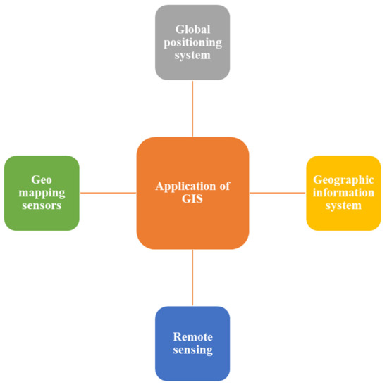
Figure 4.
Application of GIS in the agriculture sector.
5. Agricultural Waste as a Means of Biomass Energy Resource
In many nations, the use of agricultural waste as a feedstock for renewable energy has gained popularity. Agriculture residues across agricultural dominated countries such as India and China could be a significant source of biomass oil. Efficient research and production into crop residue use, including crop straw and residues as a possible feedstock for biomass electricity, has been shown in many parts of the world and India [63,64,65]. Some of these researches with special emphasis on rice residue are discussed briefly below.
Gadde et al. [66] studied the quality of rice straw as a fuel source and green house gas (GHG) pollution attributable to its current uses, as well as the capacity to save GHG while straw is used for power generation. India, Thailand, and the Philippines contain annual rice straw residue of 97, 19, 21, 86, and 10, 68 Mt. In India, remains that were produced as surplus or were unused was 23 per cent of the rice straw residue. The three big rice straw growing states of India are Haryana, Uttar Pradesh and Punjab. In Thailand and the Philippines, 48–95% of the rice straw residue was used in open-field burning. GHG emissions were 0.05 per cent, 0.18 per cent, and 0.56 per cent, respectively, due to rice straw burn on an open field in India, the Philippines, as well as Thailand. The reduction capacity for GHG pollution from rice straw power would be 0.75%, 1.81% and 4.31%, respectively, in India, Thailand and the Philippines compared to total world GHG emissions. Lim et al. [67] analyzed key factors in the use of rice husk and rice straw as a type of renewable energy. They checked physical and chemical characteristics that affect rice biomass consistency, numerous chemical and physical pre-treatment techniques that promote rice straw and husk handling and transportation, and thermo-chemical state-of-the-art and bio-chemical developments for the energy processing of rice husk and rice straw. The use of rice straw and rice husk for energy will take advantage of the environmental and economic advantages of rice-growing countries such as China, India and Indonesia. The heat and electricity produced from the power generation systems for rice residues could be used to meet local energy needs. Methane and hydrogen generated by different processes of rice biomass conversion can also generate heat and power generation resources. Ethanol can also be derived from rice straw as a transport source. Also proposed in the paper is more work on the successful marketing of rice straw and rice husk-related technology for small-scale and industrial application. In a two-chamber microbial fuel cell (MFC) inoculated with a mixed population of cellulose reducing bacteria (CDB), [68] electricity generation from rice straw without pre-treatment was demonstrated. CBD is a mixed community of bacteria that under anaerobic conditions can hydrolyse cellulosic biomass. Our research has shown that rice straw can produce electricity by using CDB as a biocatalyst. This process offers a good way to use rice straw for the development of bioenergy. Mussoline et al. [69] used untreated rice straw in a farm-scale biogas network to generate electricity in conjunction with piggery wastewater. The authors proposed a minimum wastewater straw (dry wt.) ratio of 1 to 1.4 to increase gas production and lower the acclimatization time. We also proposed enhancements such as continual recirculation of leachate, a more efficient system of heat exchange, to preserve the mesophilic conditions throughout the year, and regular application of fresh wastewater and acclimatized sludge to lignocellulose material to create a more productive and competitive environment. Hu et al. [70] studied the dissemination on the Taiwanese power sector of rice straw co-firing devices. They also developed a linear complementary model to predict the equilibrium of the power sector with the co-firing system in Taiwan. The GIS-based model also assesses the geospatial linkages between rice farms and power plant to determine the available biomass for straw oil production. Ranjan et al. [71] explored the possibility of using rice straw as a bio-butanol substratum. The researched clostridia fermentation for stress-assisted acid hydrolyzed rice straw revealed a typical acid genesis pattern accompanied by solvent genesis. The assumption was that a higher yield of solvents and substantial use of sugar renders rice straw a good feedstock for the development of biofuels.
6. Perspectives in GIS Application
Some issues that may affect GIS performance quality are deliberated below:
(1) Random field visits to the pre- and post-GIS samples zones are vital to determine GIS mapping precision. Structural accuracy evaluation using standard approaches such as error matrix computation (also known as uncertainty matrix) will improve the precision of the GIS performance. The least mapping correctness would be 85% for bioenergy planning involving land use mapping [72]. (2) The value of GIS performance depends on the satellite/digital image used in the research. For example, a powerful performance plot and use map can be generated using an image of medium determination (for example, a 23.5 m spatial determination LISS-III satellite image). Nonetheless, costs of mapping efficient road network for transporting biomass, a high-resolution image (e.g., a 5.8 m spatial resolution LISS-IV image) is required to obtain all the details of a study area’s major and minor roads. (3) Certain criteria for higher mapping accuracy include accurate image process in terms of geo-referencing, radiometric calibration, image enhancement, noise reduction, and post-classification smoothening. (4) The collection of the system of object classification (digital vs. manual) can also affect the excellence of GIS products. Furthermore, the precise preparation of bioenergy requires careful consideration of the foregoing points before initiating GIS planning.
7. Conclusions
The estimation of biomass resources is a dynamic task involving details and a high-resolution mapping technique in GIS application and survey data. Nowadays, GIS application is gaining a lot of attention, as it saves time. GIS application is also used in agriculture where the leftover biomass residue on the agricultural field can be estismated. Satellite data are commonly used for measurement in the GIS application. Lots of agricultural residues are left without any use, which can be harnessed to produce renewable energy where GIS may play a vital role. Applications of GIS in agriculture has gained much attention from researchers around the world due to its significance, and considering the power crisis in world, it can be beneficial in terms of meeting the energy supply and demand. Young farmers are eager to learn and apply modern technology to the agriculture, and there should be consistent policy framework to solve the challenges that are being faced by farmers. GIS application is benefical and may be used by farmers for many benefits, starting from biomass management to renewable enrgy production. By adopting new technologies of farming, it can solve farmers’ economical problems too. GIS as a tool can bring a tangible impact in the country and may also contribute to energy security at a global level.
Author Contributions
A.B. and K.P. contributed equally as Joint First Author. A.B., Conceptualization, Data Curation, Writing—Original Draft; K.P., Conceptualization, Data Curation, Figure, Table and Review Editing; V.R.M., Methodology and Review Editing; A.C., Formal Analysis, Review and Editing; V.V., Project Administration, Conceptualization, Supervision, Resources, Review and Editing. All authors have read and agreed to the published version of the manuscript.
Funding
This research received no external funding and The APC was funded by Swedish University of Agricultural Sciences, Alnarp, Sweden.
Institutional Review Board Statement
Not applicable.
Informed Consent Statement
Not applicable.
Data Availability Statement
Not applicable.
Acknowledgments
A.B. and K.P. acknowledge the Malaviya National Institute of Technology, Jaipur, for the infrastructure and lab. V.R.M. thanks the Center for Geoinformatics Applications for Rural Development, Government of India. A.C. would like to thank SLU Sweden for the facilities. V.V. would like to thank Malaviya National Institute of Technology, Jaipur, India for facilities and infrastructure.
Conflicts of Interest
The authors declare no conflict of interest.
References
- Gadde, B.; Menke, C.; Wassmann, R. Rice straw as a renewable energy source in India, Thailand, and the Philippines: Overall potential and limitations for energy contribution and greenhouse gas mitigation. Biomass Bioenergy 2009, 33, 1532–1546. [Google Scholar] [CrossRef]
- Ailawadi, V.S.; Bhattacharyya, S.C. Access to energy services by the poor in India: Current situation and need for alternative strategies. Nat. Resour. Forum. 2006, 30, 2–14. [Google Scholar] [CrossRef]
- Bhattacharyya, S.C. Energy access problem of the poor in India: Is rural electrification remedy? Energy Policy 2006, 34, 3387–3397. [Google Scholar] [CrossRef]
- Ministry of New and Renewable Energy. Annual Report 2010–11. Available online: http://www.mnre.gov.in/annualreport/2010_11_English/index.htm (accessed on 13 September 2020).
- Ministry of New and Renewable Energy. India, Biomass for Sustainable Development-Lessons for Decentralized Energy Delivery Village Energy Security Programme. Document of the World Bank; 2011. Available online: http://www.mnre.gov.in/pdf/VESP-Final-Report-July%202011.pdf (accessed on 8 October 2020).
- Long, H.; Li, X.; Wang, H.; Jia, J. Biomass resources and their bioenergy potential estimation: A review. Renew. Sustain. Energy Rev. 2013, 26, 344–352. [Google Scholar] [CrossRef]
- Alfonso, D.; Perpiñá, C.; Pérez-Navarro, A.; Peñalvo, E.; Vargas, C.; Cárdenas, R. Methodology for optimization of distributed biomass resources evaluation, management and final energy use. Biomass Bioenergy 2009, 33, 1070–1079. [Google Scholar] [CrossRef]
- Stephen, J.D.; Sokhansanj, S.; Bi, X.; Sowlati, T.; Kloeck, T.; Townley-Smith, L.; Stumborg, M.A. Analysis of biomass feedstock availability and variability for the Peace River region of Alberta, Canada. Biosyst. Eng. 2010, 105, 103–111. [Google Scholar] [CrossRef]
- Beccali, M.; Columba, P.; D’Alberti, V.; Franzitta, V. Assessment of bioenergy potential in Sicily: A GIS-based support methodology. Biomass Bioenergy 2009, 33, 79–87. [Google Scholar] [CrossRef]
- Gómez, A.; Rodrigues, M.; Montañés, C.; Dopazo, C.; Fueyo, N. The potential for electricity generation from crop and forestry residues in Spain. Biomass and Bioenergy 2010, 34, 703–719. [Google Scholar] [CrossRef]
- Jiang, D.; Zhuang, D.; Fu, J.; Huang, Y.; Wen, K. Bioenergy potential from crop residues in China: Availability and distribution. Renew. Sustain. Energy Rev. 2012, 16, 1377–1382. [Google Scholar] [CrossRef]
- Mafakheri, F.; Nasiri, F. Modeling of biomass-to-energy supply chain operations: Applications, challenges and research directions. Energy Policy 2014, 67, 116–126. [Google Scholar] [CrossRef]
- Fiedler, P.; Lange, M.; Schultze, M. Supply logistics for the industrialized use of biomass-principles and planning approach. In Proceedings of the 2007 International Symposium on Logistics and Industrial Informatics, Wildau, Germany, 13–15 September 2007; pp. 41–46. [Google Scholar]
- Perpina, C.; Alfonso, D.; Pérez-Navarro, A.; Penalvo, E.; Vargas, C.; Cárdenas, R. Methodology based on Geographic Information Systems for biomass logistics and transport optimisation. Renew. Energy 2009, 34, 555–565. [Google Scholar] [CrossRef]
- Nunes, L.J.R.; Causer, T.P.; Ciolkosz, D. Biomass for energy: A review on supply chain management models. Renew. Sustain. Energy Rev. 2020, 120, 109658. [Google Scholar] [CrossRef]
- Hiloidhari, M.; Baruah, D.C. Crop residue biomass for decentralized electrical power generation in rural areas (part 1): Investigation of spatial availability. Renew. Sustain. Energy Rev. 2011, 15, 1885–1892. [Google Scholar] [CrossRef]
- Zubaryeva, A.; Zaccarelli, N.; Del Giudice, C.; Zurlini, G. Spatially explicit assessment of local biomass availability for distributed biogas production via anaerobic co-digestion–Mediterranean case study. Renew. Energy 2012, 39, 261–270. [Google Scholar] [CrossRef]
- Shi, X.; Elmore, A.; Li, X.; Gorence, N.J.; Jin, H.; Zhang, X.; Wang, F. Using spatial information technologies to select sites for biomass power plants: A case study in Guangdong Province, China. Biomass Bioenergy 2008, 32, 35–43. [Google Scholar] [CrossRef]
- Yu, H.; Wang, Q.; Ileleji, K.E.; Yu, C.; Luo, Z.; Cen, K.; Gore, J. Design and analysis of geographic distribution of biomass power plant and satellite storages in China. Part 1: Straight-line delivery. Biomass Bioenergy 2012, 46, 773–784. [Google Scholar] [CrossRef]
- Egbendewe-Mondzozo, A.; Swinton, S.M.; Izaurralde, C.R.; Manowitz, D.H.; Zhang, X. Biomass supply from alternative cellulosic crops and crop residues: A spatially explicit bioeconomic modeling approach. Biomass Bioenergy 2011, 35, 4636–4647. [Google Scholar] [CrossRef]
- Singh, J.; Panesar, B.S.; Sharma, S.K. Geographical distribution of agricultural residues and optimum sites of biomass based power plant in Bathinda, Punjab. Biomass Bioenergy 2011, 35, 4455–4460. [Google Scholar] [CrossRef]
- Kaundinya, D.P.; Balachandra, P.; Ravindranath, N.H.; Ashok, V. A GIS (geographical information system)-based spatial data mining approach for optimal location and capacity planning of distributed biomass power generation facilities: A case study of Tumkur district, India. Energy 2013, 52, 77–88. [Google Scholar] [CrossRef]
- Haase, M.; Rösch, C.; Ketzer, D. GIS-based assessment of sustainable crop residue potentials in European regions. Biomass Bioenergy 2016, 86, 156–171. [Google Scholar] [CrossRef]
- Malico, I.; Carrajola, J.; Gomes, C.P.; Lima, J.C. Biomass residues for energy production and habitat preservation. Case study in a montado area in Southwestern Europe. J. Clean. Prod. 2016, 112, 3676–3683. [Google Scholar] [CrossRef]
- Garcia, D.A.; Sangiorgio, S.; Rosa, F. Estimating the potential biomasses energy source of forest and agricultural residues in the Cinque Terre Italian National Park. Energy Procedia 2015, 82, 674–680. [Google Scholar] [CrossRef]
- Lourinho, G.; Brito, P. Assessment of biomass energy potential in a region of Portugal (Alto Alentejo). Energy 2015, 81, 189–201. [Google Scholar] [CrossRef]
- Höhn, J.; Lehtonen, E.; Rasi, S.; Rintala, J. A Geographical Information System (GIS) based methodology for determination of potential biomasses and sites for biogas plants in southern Finland. Appl. Energy 2014, 113, 1–10. [Google Scholar] [CrossRef]
- Hu, M.C.; Huang, A.L.; Wen, T.H. GIS-based biomass resource utilization for rice straw cofiring in the Taiwanese power market. Energy 2013, 55, 354–360. [Google Scholar] [CrossRef]
- Ramachandra, T.V.; Krishna, S.V.; Shruthi, B.V. Decision support system to assess regional biomass energy potential. Int. J. Green Energy 2005, 1, 407–428. [Google Scholar] [CrossRef]
- Fiorese, G.; Guariso, G. A GIS-based approach to evaluate biomass potential from energy crops at regional scale. Environ. Model. Softw. 2010, 25, 702–711. [Google Scholar] [CrossRef]
- Thomas, A.; Bond, A.; Hiscock, K. A GIS based assessment of bioenergy potential in England within existing energy systems. Biomass Bioenergy 2013, 55, 107–121. [Google Scholar] [CrossRef]
- Zhang, F.; Johnson, D.M.; Sutherland, J.W. A GIS-based method for identifying the optimal location for a facility to convert forest biomass to biofuel. Biomass Bioenergy 2011, 35, 3951–3961. [Google Scholar] [CrossRef]
- Ćosić, B.; Stanić, Z.; Duić, N. Geographic distribution of economic potential of agricultural and forest biomass residual for energy use: Case study Croatia. Energy 2011, 36, 2017–2028. [Google Scholar] [CrossRef]
- Fernandes, U.; Costa, M. Potential of biomass residues for energy production and utilization in a region of Portugal. Biomass Bioenergy 2010, 34, 661–666. [Google Scholar] [CrossRef]
- Igliński, B.; Buczkowski, R.; Iglińska, A.; Cichosz, M.; Piechota, G.; Kujawski, W. Agricultural biogas plants in Poland: Investment process, economical and environmental aspects, biogas potential. Renew. Sustain. Energy Rev. 2012, 16, 4890–4900. [Google Scholar] [CrossRef]
- Tenerelli, P.; Carver, S. Multi-criteria, multi-objective and uncertainty analysis for agro-energy spatial modelling. Appl. Geogr. 2012, 32, 724–736. [Google Scholar] [CrossRef]
- Yoshioka, T.; Sakurai, R.; Aruga, K.; Sakai, H.; Kobayashi, H.; Inoue, K. A GIS-based analysis on the relationship between the annual available amount and the procurement cost of forest biomass in a mountainous region in Japan. Biomass Bioenergy 2011, 35, 4530–4537. [Google Scholar] [CrossRef]
- Sacchelli, S.; De Meo, I.; Paletto, A. Bioenergy production and forest multifunctionality: A trade-off analysis using multiscale GIS model in a case study in Italy. Appl. Energy 2013, 104, 10–20. [Google Scholar] [CrossRef]
- Zhuang, D.; Jiang, D.; Liu, L.; Huang, Y. Assessment of bioenergy potential on marginal land in China. Renew. Sustain. Energy Rev. 2011, 15, 1050–1056. [Google Scholar] [CrossRef]
- Angelis-Dimakis, A.; Biberacher, M.; Dominguez, J.; Fiorese, G.; Gadocha, S.; Gnansounou, E.; Robba, M. Methods and tools to evaluate the availability of renewable energy sources. Renew. Sustain. Energy Rev. 2011, 15, 1182–1200. [Google Scholar] [CrossRef]
- Sun, Y.; Wang, R.; Liu, J.; Xiao, L.; Lin, Y.; Kao, W. Spatial planning framework for biomass resources for power production at regional level: A case study for Fujian Province, China. Appl. Energy 2013, 106, 391–406. [Google Scholar] [CrossRef]
- Roberts, J.J.; Cassula, A.M.; Prado, P.O.; Dias, R.A.; Balestieri, J.A.P. Assessment of dry residual biomass potential for use as alternative energy source in the party of General Pueyrredón, Argentina. Renew. Sustain. Energy Rev. 2015, 41, 568–583. [Google Scholar] [CrossRef]
- Panichelli, L.; Gnansounou, E. GIS-based approach for defining bioenergy facilities location: A case study in Northern Spain based on marginal delivery costs and resources competition between facilities. Biomass Bioenergy 2008, 32, 289–300. [Google Scholar] [CrossRef]
- Lovett, A.A.; Sünnenberg, G.M.; Richter, G.M.; Dailey, A.G.; Riche, A.B.; Karp, A. Land use implications of increased biomass production identified by GIS-based suitability and yield mapping for Miscanthus in England. Bioenergy Res. 2009, 2, 17–28. [Google Scholar] [CrossRef]
- Yue, C.D.; Wang, S.S. GIS-based evaluation of multifarious local renewable energy sources: A case study of the Chigu area of southwestern Taiwan. Energy Policy 2006, 34, 730–742. [Google Scholar] [CrossRef]
- Frombo, F.; Minciardi, R.; Robba, M.; Rosso, F.; Sacile, R. Planning woody biomass logistics for energy production: A strategic decision model. Biomass Bioenergy 2009, 33, 372–383. [Google Scholar] [CrossRef]
- Singh, J.; Panesar, B.S.; Sharma, S.K. Energy potential through agricultural biomass using geographical information system—A case study of Punjab. Biomass Bioenergy 2008, 32, 301–307. [Google Scholar] [CrossRef]
- Masera, O.; Ghilardi, A.; Drigo, R.; Trossero, M.A. WISDOM: A GIS-based supply demand mapping tool for woodfuel management. Biomass Bioenergy 2006, 30, 618–637. [Google Scholar] [CrossRef]
- Ma, J.; Scott, N.R.; DeGloria, S.D.; Lembo, A.J. Siting analysis of farm-based centralized anaerobic digester systems for distributed generation using GIS. Biomass Bioenergy 2005, 28, 591–600. [Google Scholar] [CrossRef]
- Ramachandra, T.V.; Shruthi, B.V. Spatial mapping of renewable energy potential. Renew. Sustain. Energy Rev. 2007, 11, 1460–1480. [Google Scholar] [CrossRef]
- McHarg, I.L.; Mumford, L. Design with Nature; American Museum of Natural History: New York, NY, USA, 1969. [Google Scholar]
- Hopkins, L.D. Methods for generating land suitability maps: A comparative evaluation. J. Am. Inst. Plan. 1977, 43, 386–400. [Google Scholar] [CrossRef]
- Brail, R.K.; Klosterman, R.E. Planning Support Systems: Integrating Geographic Information Systems, Models, and Visualization Tools; ESRI, Inc.: Redlands, CA, USA, 2001. [Google Scholar]
- Akıncı, H.; Özalp, A.Y.; Turgut, B. Agricultural land use suitability analysis using GIS and AHP technique. Comput. Electron. Agric. 2013, 97, 71–82. [Google Scholar] [CrossRef]
- Wang, Y.Q.; Zhang, X.Y.; Draxler, R.R. TrajStat: GIS-based software that uses various trajectory statistical analysis methods to identify potential sources from long-term air pollution measurement data. Environ. Model. Softw. 2009, 24, 938–939. [Google Scholar] [CrossRef]
- Rey, D.; Holman, I.P.; Daccache, A.; Morris, J.; Weatherhead, E.K.; Knox, J.W. Modelling and mapping the economic value of supplemental irrigation in a humid climate. Agric. Water Manag. 2016, 173, 13–22. [Google Scholar] [CrossRef]
- Singh, A.K.; Dubey, O.P.; Ghosh, S.K. Irrigation scheduling using intervention of Geomatics tools—A case study of Khedli minor. Agric. Water Manag. 2016, 177, 454–460. [Google Scholar] [CrossRef]
- Hinojosa, L.; Napoléone, C.; Moulery, M.; Lambin, E.F. The “mountain effect” in the abandonment of grasslands: Insights from the French Southern Alps. Agric. Ecosyst. Environ. 2016, 221, 115–124. [Google Scholar] [CrossRef]
- Li, H.; Zhang, X. A spatial explicit assessment of food security in Africa based on simulated crop production and distribution. J. Clean. Prod. 2017, 147, 628–636. [Google Scholar] [CrossRef]
- AbdelRahman, M.A.; Natarajan, A.; Hegde, R. Assessment of land suitability and capability by integrating remote sensing and GIS for agriculture in Chamarajanagar district, Karnataka, India. Egypt. J. Remote Sens. Space Sci. 2016, 19, 125–141. [Google Scholar] [CrossRef]
- Zhao, Q.; Lenz-Wiedemann, V.; Yuan, F.; Jiang, R.; Miao, Y.; Zhang, F.; Bareth, G. Investigating within-field variability of rice from high resolution satellite imagery in Qixing Farm County, Northeast China. ISPRS Int. J. Geo Inf. 2015, 4, 236–261. [Google Scholar] [CrossRef]
- Blasch, G.; Spengler, D.; Hohmann, C.; Neumann, C.; Itzerott, S.; Kaufmann, H. Multitemporal soil pattern analysis with multispectral remote sensing data at the field-scale. Comput. Electron. Agric. 2015, 113, 1–13. [Google Scholar] [CrossRef]
- Paritosh, K.; Vivekanand, V. Biochar enabled syntrophic action: Solid state anaerobic digestion of agricultural stubble for enhanced methane production. Bioresour. Technol. 2019, 289, 121712. [Google Scholar] [CrossRef]
- Paritosh, K.; Pareek, N.; Chawade, A.; Vivekanand, V. Prioritization of solid concentration and temperature for solid state anaerobic digestion of pearl millet straw employing multi-criteria assessment tool. Sci. Rep. 2019, 9, 1–11. [Google Scholar]
- Paritosh, K.; Balan, V.; Vijay, V.K.; Vivekanand, V. Simultaneous alkaline treatment of pearl millet straw for enhanced solid state anaerobic digestion: Experimental investigation and energy analysis. J. Clean. Prod. 2020, 252, 119798. [Google Scholar] [CrossRef]
- Athira, G.; Bahurudeen, A.; Appari, S. Sustainable alternatives to carbon intensive paddy field burning in India: A framework for cleaner production in agriculture, energy, and construction industries. J. Clean. Prod. 2019, 236, 117598. [Google Scholar] [CrossRef]
- Lim, J.S.; Manan, Z.A.; Alwi, S.R.W.; Hashim, H. A review on utilisation of biomass from rice industry as a source of renewable energy. Renew. Sustain. Energy Rev. 2012, 16, 3084–3094. [Google Scholar] [CrossRef]
- Hassan, S.H.; El-Rab, S.M.G.; Rahimnejad, M.; Ghasemi, M.; Joo, J.H.; Sik-Ok, Y.; Oh, S.E. Electricity generation from rice straw using a microbial fuel cell. Int. J. Hydrog. Energy 2014, 39, 9490–9496. [Google Scholar] [CrossRef]
- Mussoline, W.; Esposito, G.; Giordano, A.; Lens, P. The anaerobic digestion of rice straw: A review. Crit. Rev. Environ. Sci. Technol. 2013, 43, 895–915. [Google Scholar] [CrossRef]
- Hiloidhari, M.; Baruah, D.C.; Singh, A.; Kataki, S.; Medhi, K.; Kumari, S.; Ramachandra, T.V.; Jenkins, B.M.; Thakur, I.S. Emerging role of Geographical Information System (GIS), Life Cycle Assessment (LCA) and spatial LCA (GIS-LCA) in sustainable bioenergy planning. Bioresour. Technol. 2017, 242, 218–226. [Google Scholar] [CrossRef]
- Ranjan, A.; Khanna, S.; Moholkar, V.S. Feasibility of rice straw as alternate substrate for biobutanol production. Appl. Energy 2013, 103, 32–38. [Google Scholar] [CrossRef]
- Foody, G.M. Status of land covers classification accuracy assessment. Remote Sens. Environ. 2002, 80, 185–201. [Google Scholar] [CrossRef]


Publisher’s Note: MDPI stays neutral with regard to jurisdictional claims in published maps and institutional affiliations. |
© 2021 by the authors. Licensee MDPI, Basel, Switzerland. This article is an open access article distributed under the terms and conditions of the Creative Commons Attribution (CC BY) license (http://creativecommons.org/licenses/by/4.0/).