1. Introduction
Spatial planning and the wider contexts of spatial management or organisation are tools by which policies and strategies for the development of areas (including rural areas) can be pursued. Spatial planning and the quality thereof are thus of key importance in establishing a long-term, sustainable framework of social, territorial and economic development. At the beginning of the 2000s, Poland joined the other CEECs on the threshold of EU accession, however, by that time, the member states had already spent more than a decade together shaping the main assumptions underpinning spatial planning at the EU level, thanks to the pursuit of assumptions set out in a succession of documents including Europe 2000, Europe 2000+, the European Spatial Development Perspective (ESDP) and INTERREG [
1,
2,
3,
4].
Meanwhile, Poland and the other candidate countries were still at this point, continuing with their transitions from the communist-era past through to democracy and market-oriented economies. To only a limited extent could they also join in shaping the future spatial policy of the EU. In this context, the accession of new states was treated as a challenge, given the way it did much to increase the historical and cultural diversity existing within the European Union, with this also reflected in the different degrees of implementation of the aforementioned ESDP, not least because of the “design of political institutions, including how it frames the general activities of government and its relationships with citizens” [
3].
Nearly 20 years on, and in the wake of a variety of different experiences of implementing the ESDP (and later, the Territorial Agendas of 2007 and 2011) [
5,
6], planning remained beyond the remit of the EU in the strict sense, as noted by Dąbrowski and Piskorek [
7], even as many initiatives and programmes continued to ensure an ongoing Europeanisation of spatial planning [
4,
8,
9]. The influence of the EU on the planning agendas, structures and policies of the Member States is noticeable [
10,
11], however, the previous and current financing periods were characterised by policies and programmes pursued at the European level and failing to make direct reference to issues of spatial planning in rural areas.
In the aforementioned ESDP, the matter of rurality made its presence indirectly felt in the context of Europe’s peripheral areas, urban–rural relations and the restructuring of rural areas that were in decline [
12]. This gave rise to a well-founded assumption—persisting for many years—that this spatial planning is more akin to urban planning, with rural areas being tantamount to problem areas in need of intervention. According to Gallent et al. [
13], for several decades now, rural planning has corresponded with the special challenges being faced in rural areas: “(…) the changing ‘economies’ of rural areas, ‘societal’ shifts resulting from these economic changes, and consequent ‘environmental’ issues”. The EU’s influence in shaping rural areas has been very considerable, and also in multiple contexts, for many years now [
14,
15,
16,
17,
18,
19,
20].
In contrast, smart rural development is a relatively new concept under the social, economic and spatial policy of the UN [
21]. However, it may become one of the leading activities in planning, requiring financial support from funds in the EU context, not least programmes for the development of rural areas and agriculture. Activity on the part of key players in local development seeks to achieve the faster modernisation of rural areas, not only in an economic sense, but also through the building of ever-more-aware civic and community-minded attitudes. Many authors have considered that the research aspect needs to be emphasised, as regards the smart development concept in the rural environment, which also includes under specifically Polish circumstances [
22,
23,
24].
In this article, we focused on the role that local government plays, as well as the tasks conferred upon it, when it comes to ensuring an appropriate quality of life for people, i.e., as regards the spatial order. Key elements here are forms of communication within the community, between local leaders and inhabitants. This, in turn, ensures the importance of different aspects of the functioning of the unit of local government and the community that is the Polish gmina, with innovative solutions on this tier of administration operating to reduce the distance between leaders in local authority and citizens. The status of “smart village” or “smart rural area” thus denotes, first and foremost, the activity on the part of the local authority—and the institutions cooperating with it—which leads to the increased transparency of decision-making and spatial-management processes.
A matter of importance from this point of view is the transparency of the spatial planning engaged in by Poland’s gminas as units of local government responsible for relevant law making [
25]. In this context, it is crucial that there should be innovative solutions based around the use of modern digital technologies. While these were optional at the outset, they have now become standard and indeed imperative. The
GeoDesign concept is understood as the planning and design of space on the basis of broad resources of information (capable of being gathered solely if modern technologies and GIS are used), and with active engagement on the part of inhabitants. For the process of
GeoDesign, several stages are indicated which include the mapping of the environment, the forecasting of possible phenomena and processes, the compilation of mapped data along with those obtained through analyses carried out, project planning and design based around several different variants, and ultimately the selection of the best project.
Each of the variants referred to that are developed ought to be presented to local communities so that these can offer their opinions. The use of
webGIS provides for easier communication of this kind with inhabitants, and—thanks to it—the latter can indeed express their own opinions, indicate weak points and put forward alternative solutions.
GeoDesign ensures that any project arrived is ultimately the joint creation of project developers and designers, experts and members of local communities. To express things in general terms,
GeoDesign serves in the shaping of projects, thus taking into account both natural and socio-cultural conditioning. Decision making is facilitated, as is the optimal use of possessed resources. A chance is also offered for new projects to be put in place, in line with the principles developed for the spatial order [
26]. However, if the spatial planning of this kind is to even be possible in rural areas, the necessary potential has to be put in place, with this, i.e., including clear and stable legal regulations for the system, as well as an appropriate level of digitalisation, and standardisation that can ensure the dissemination and sharing of spatial information.
The considerations presented above in regard to the place of rural planning and rural development in the traditional way of looking at the Europeanisation of spatial planning, as well as new concepts of smart rural development and GeoDesign, can serve as a broad context for the work presented in this article, which sought to make its contribution to the debate on the future of rural development and the potential for rural areas to rise to the challenges of modernity, not least the digital transformation and so-called “Fourth Industrial Revolution” [
27,
28,
29].
Specifically, the work detailed herein has sought to assess the level of digitalisation achieved by spatial planning, with this in turn making it possible to define the potential at the disposal of different gminas, as they seek to bring in the idea of smart rural development. Beyond that, there is the potential to move over to a new philosophy by which territory is shaped on the basis of the
GeoDesign concept [
30].
The subject of assessment here was thus the degree of advancement of planning work in gminas, as well as their development of online portals (geoportals) that present the conditioning and directions of spatial policy present in rural gminas. We sought to determine how advanced rural gminas are when it comes to implementation of the EU’s 2007 INSPIRE Directive—one obligation under which is the development (and dissemination) of spatial datasets that also relate to spatial planning. This is a circumstance and situation we present here for Poland’s Łódź region, as delineated by the boundaries of one of the 16 regional-provincial level units of administration known as voivodeships into which Poland is divided.
In the above context, the first part of this article offers a presentation on how the system of spatial planning in Poland has taken shape; with particular attention here being paid to the context linked up with the digitalisation of the planning process; and with it thus proving it possible to determine certain milestones that are important—in theory or in practice—to the implementation of the idea of smart rural development in rural gminas of Poland.
A further stage has involved the description of the materials, data and methods of analysis we deployed; which is followed by the presentation of results on planning coverage and degrees of digitalisation of the planning system—with references here made to the digitisation/digitalisation of planning documents (and documentation), with these being further disseminated through geoportals. Data on the levels of planning and functionality of geoportals here serve an assessment of potential for the GeoDesign concept to be implemented and pursued in the study region’s rural gminas. The results obtained are then discussed in relation to the assumptions considered to underpin the concepts of both the smart rural development and the neo-endogenous development of rural areas. The article concludes with a short section offering the main conclusions of our work.
2. The Evolution of Spatial Planning Paradigms in Poland
Poland’s system of spatial planning emerged post-War in response to the rapid and major growth of towns and cities and associated processes of suburbanisation. Ultimately, the practice shaped at that time came to be markedly transformed with the political and systemic change achieved rather abruptly since 1989. A major step involved in these transformations was the enfranchisement of local communities, with local government reactivated at the level of the gmina. There was also a rapid adoption of the rules of the market economy in Poland, and an introduction of political pluralism and the principles of the democratic state as duly constituted and governed by the rule of law. From the spatial planning point of view, the latter was of no minor significance, as it required a complete changeover of the system.
Thus, the system now in place and in operation in this country reflects adjustments to conditions of a transformed political and governance system taking place during the period 1989–1994, the introduction of a new model during the period 1995–2003, and further “course adjustments” to that model taking place in the years since 2003.
However, principles regarding the hierarchy in spatial planning that were determined and put in place during the 1990s remain in force [
31], and key amongst these is the primacy of the gmina in matters of planning. Equally, where the hierarchy of actual spatial plans is concerned, there is a tenet that local plans must be cohesive vis-à-vis the spatial development plans on the higher administrative tier of the voivodeship, with the latter naturally needing to fall in line with what is determined by the Council of Ministers of the Republic of Poland for that entire country.
Communal planning jurisdiction at the gmina level, nevertheless, denotes conferment upon gminas (i.e., transfer down to the local level) of competences where spatial policies are concerned, with effect being given to these in instruments of local law enacted to cover the territory of the given gmina. While the 2000s did bring amendment of the law on spatial planning—with a series of minor adjustments made, what happened first and foremost was a determining of the scope in which—as well as the forms and means by which—citizens could play their part in spatial planning. The result was for the state, the gmina and citizens to become equal partners in a planning process foreseen to involve constant, ongoing negotiation and consultation.
This idea of public participation is obviously of exceptional importance to the planning process, as was stressed in the United Nations international standards [
32], among others. The many tangible benefits of this have included an improved quality of decision-making and fuller legitimisation of the activity of public authorities as well as cost-reductions…, but also delays with the implementation of actual work. UN standards also draw attention to the significance of processes being transparent, with channels needing to be made available for standpoints to be developed and articulated, along with procedures providing for possible appeals against decisions taken. The matter of citizens’ access to information is also of significance.
Indeed, universal or widespread access to information concerning space—as broadly conceived—is closely linked with the public (and community) involvement and participation in spatial planning. Furthermore, alongside the current development of modern technology, we see here key prerequisites for planning effectiveness founded upon the participatory model. For example, Waidemann and Femers [
33] refer to a participatory scale of their own authorship, with the level of participation seen to increase in line with the degree of access to information. The lowest rung of the participation ladder was defined in terms of “the public right to know”, “informing the public” and the “public right to object”—and this all corresponds with the minimum amount of information made available to citizens by the authorities, with this in turn thought to denote tokenism, and hence participation of a superficial nature only [
34].
It is only where there is a real increase in amounts of information made available that we see a genuinely raised level of participation of citizens in decision-making, with “public participation in defining interests and determining the agenda”, “public participation in assessing risk and recommending solutions”, and even the highest level of all denoting “public partnership in the final decision”.
A significant role for access to information regarding space was also invoked by
the joint United Nations-FIG Bathurst Declaration on Land Administration for Sustainable Development—a turn-of-the-21st-century document that pointed towards the reform of spatial planning systems around the world that would facilitate the achievement of sustainability goals. Indeed, in the context of the evolution of planning systems, the authors of the Declaration claim: “information technology will play an increasingly important role both in constructing the necessary infrastructure and in providing effective citizen access to information”. Furthermore, we point out herein the interrelated, interconnected nature of elements such as good land information; better land policy; better land administration and management; and better land use [
35].
In the European Union, in 2009, the EP adopted the Directive popularly known as INSPIRE [
36]. Its transposition into Poland’s domestic law occurred in 2010, as an encouraging initiation of work on the country’s spatial information infrastructure, implementing standards that favoured the unification of geospatial data and increasing the opportunities for efficient processing and dissemination. Indeed, it was within the framework of the INSPIRE Directive that Poland—like remaining EU Member States—set up its national geoportal, allowing for access in the form of network services in a position to harmonise resources of spatial data.
It was also in this connection that the gminas representing the local level of administration in Poland assumed responsibility for eight subjects of spatial data, i.e., addresses, plots as registered by means of land registry, buildings, soil, services of public utility and state services, area in use or under management, zones subject to restrictions or special regulations, and units responsible for reporting. However, notwithstanding the transposition and implementation of the INSPIRE Directive, Poland lacked regulations emphasising that spatial data for planning documents needed to be generated. Furthermore, a standard laying out the principles for digital data planning was missing.
The result of these shortfalls was the emergence of non-uniform data, with these often also relying on non-standardised nomenclature. This, in turn, hindered or in some cases even prevented the compiling of data from different sources and the development of spatial analyses. This situation changed in 2020, with the amendment of the Republic of Poland’s Act on Spatial Management and Planning (the Dziennik Ustaw Official Journal of Laws 2003 No. 80, item 717, as amended subsequently). This obliged the organs issuing Spatial Planning Instruments (including the gminas doing so at the local level) to engage in planning based around digital data—with the latter also taken to relate to the instruments already in force. The digitisation of planning documents works to ensure that uniform and unified sets of data are established, with these detailing the scope of the instruments concerned, as well as the documents associated with them—in order for access to be be more rapid and otherwise facilitated. The universal availability and accessibility of planning data should incite an activation of the public—and of communities—when it comes to the joint development of planning documentation using modern technology (online tools).
Changes in mechanisms of spatial planning (
Figure 1) are exceptionally important for local communities, especially in times that are dynamic from the point of view of both events and changes of conditioning. By acquainting country-dwellers with the processes involved in planning, a basis is put in place for fuller trust in decision-making bodies at the level of the individual local authority. Smart rural development requires support in the form of new technology that integrates the level of spatial organisation with the needs and objectives of social development. The direction in which spatial planning is moving in is important to the sustainability of local democracy—and is also important for the effective pursuit of an equal-opportunity policy. Broad access to new methods through which space is made subject to community negotiation is of key significance as the rural environment becomes not only more and more multifunctional, but also increasingly diversified in social terms. Furthermore, the transparency of the planning process for all stakeholders offers a basis for compromise between the users of space, as well as the development of “realistic” policy in general.
3. Materials and Methods
As noted above, the present shape of Poland’s spatial planning system reflects many aspects of conditioning from history overlain upon one another. However, the same can in fact be said of the systems of planning present in many other countries. At the European level too, land-use planning systems, and spatial planning systems in the wider sense [
13,
37], do differ from one country to another, i.e., in line with different national governance frameworks, as well as the fact that each economy and each society has its own specific features [
38,
39,
40].
Such differences between systems evidence problems when it comes to the pursuit of comparative analyses. Nevertheless, attempts have been made to carry out relevant research by way of ESPON and within the framework of
COMPASS—denoting the “Comparative Analysis of Territorial Governance and Spatial Planning Systems in Europe: Applied Research 2016–2018”. That said, in the matter of the relationship between systems of spatial planning and digitalisation, report authors claim only that: “reforms have also been made to strengthen implementation, and regularise development; to facilitate value capture from development and to adapt to digital technology. The effects of such reforms have not been evaluated in this project, but they tend to be incremental with few radical changes” [
41]. This makes it reasonable to suggest that the scheme for research proposed in this article can serve as a starting point for analogous analyses carried out in other regions.
Our empirical analyses are based on both secondary and primary data. To achieve an analysis of gminas’ levels of planning “coverage”, we used the data annually submitted to Statistics Poland by gmina authorities. The closer focus was on rural gminas in the Łódź region, with the assessment based on 2010 data, as well as the change occurring over a decade as revealed in the 2019 equivalent data. The sample involved the 120 out of 133 rural gminas for which data were available (or over 92% of the total). The compilation of values for the variables at the two instants in time in turn allowed for a classification of the inductive-method type, with the result being the identification of six key types of spatial planning.
While Statistics Poland also has data on the digitalisation of spatial planning (e.g., on the share of land covered by digitised local plans), it quickly emerged that these data were almost entirely unusable, above all, because of their outdatedness. The data available for 2019 hardly correspond to the real situation in 2021, perhaps in part because of the nature of the digitisation (and digitalisation)—which have now become very dynamic processes. In contrast, data on geoportals are not collected at all at the official level, with it therefore being necessary to engage in the independent compiling of information on the portals, as well as the local plans posted on them, and an assessment of functionality in general terms.
Thus, to achieve the goals of the research a search of local-authority websites was made—in regard to the region’s 133 rural gminas. Identified geoportals were then analysed using a simplified
Website Attribute Evaluation System (
WAES), this being a binary method entailing the simple evaluation of selected features of websites—as to whether a given feature is present on the service or not [
42,
43]. Furthermore, thanks to analogous research carried out for the rural gminas in the Łódź region in 2018, it was possible to assess the dynamics and directions of change affecting the geoportals in question.
4. Results
4.1. The Study Region
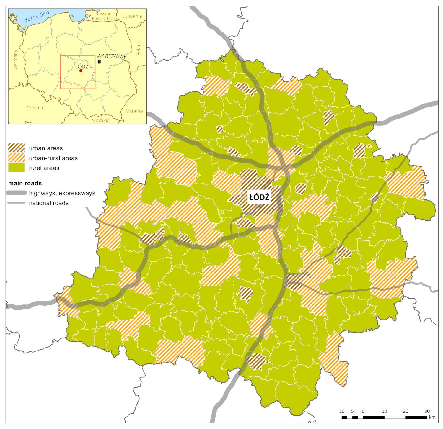
From the administrative point of view, Łódź voivodeship is further subdivided into 177 gminas (units of local-government administration), of which 18 are urban, 26 urban–rural, and 133 rural (
Figure 2). The combined area of rural gminas here is 13,500 km
(or nearly 75% of the entire region). The region’s rural gminas are in turn home to 30% of the population (or some 736,000 people).
Furthermore, Łódź voivodeship is located in central Poland and can be regarded as average in terms of both area (at 18,200 km), population (2.45 M) and degree of ruralisation (37.4%). Where overall digitalisation and progress with the digital transformation are concerned, the Łódź region again looks average in statistical terms. As of 2019, in only half of the units of public administration were there tasks relating to ICT servicing being discharged by specially designated employees or organisational units. This compared with over 70% in the region of Poland most favoured from this point of view (Warmińsko-Mazurskie voivodeship), as well as a little over 36% in the case of the weakest one (Podkarpackie voivodeship).
At the same time, around half of the administrative sub-units within the Łódź voivodeship supplied their personnel with ICT training, while the electronic management of documents is now engaged in by almost 63% (cf. 97% in NE Poland’s Podlaskie voivodeship) [
44].
In the context of the diffusion of innovation that digitalisation represents, a matter of major significance is a specific settlement structure that in turn arises out of the locations of rural areas vis-à-vis a main city (Łódź in the case of this region), as well as a relatively evenly spread network of smaller towns. In this centrally located region of Poland, it is possible to find examples of all the country’s types of rural settlement in terms of village size and distribution, whose distribution across the country is seen to be zoned [
45]. In the broader context, Poland can be treated as an interesting example of a country whose historical conditioning has ensured a system of spatial planning entirely shaped anew over a period of only three decades to date. Furthermore, the transformation this entailed perforce involved adaptation to European Union (as opposed to purely domestic) regulations, given the fact that the demanding process of EU accession occurred at the same time.
4.2. Coverage by Spatial Planning Instruments (APPs)
In accordance with the detailed provisions set out in law, the Polish system of spatial planning operates on the basis of the range of planning documents collectively known as Spatial Planning Instruments (APPs in Polish). These, in fact, include the Plan Zagospodarowania Przestrzennego Województwa (Voivodeship Spatial Development Plan—i.e., the the instrument at regional level), the studium uwarunkowań i kierunków zagospodarowania przestrzennego (study of the conditioning and directions of spatial development), as well as the miejscowy plan zagospodarowania przestrzennego (Local Physical Development Plan), miejscowy plany odbudowy (Local Restoration Plan) and the miejscowy plan rewitalizacji (Local Revitalisation Plan).
The key instruments at the local (gmina) level are the aforementioned studies of the conditioning and directions of physical development—as documents drawn up and compulsorily updated by all local authorities; and local physical development plans—as legal instruments of local application are enacted as needed. The degree of planning coverage present in different gminas can be treated as some kind of indirect indicator of their degree of smart development. While it is true that the Local Physical Development Plans do not represent the only possible routes means of locating new developments, their development does attest to an awareness of spatial management that takes into account the fundamental principles of spatial order and sustainable development in rural gminas [
46].
Alongside the Local Physical Development Plan, the law in force also recognises the decyzja o warunkach zabudowy (decision on building conditions and land development or in effect a form of planning permission) as the basis for new developments. This route is possible where no local plan is in force. However, this solution has been a subject of widespread criticism, especially from spatial planners and urban planners, given the abuse and overuse that this approach has been subject to (not least with it being issued in a manner than evades planning and physical development regulations). Attention is also of course drawn to the latter solution’s capacity to generate corruption, i.e., on account of the lack of transparency and public scrutiny that issued planning decisions have been made subject to [
31].
The results obtained nevertheless point to a generally occurring favourable direction of change in planning coverage. Over the decade under consideration, there was a near-halving (from 40 to 23) in numbers of gminas lacking a Local Physical Development Plan or being covered by such a plan to a minimal degree of 1% or less. In other groups, the coverage is seen to have risen—with this most of all noticeable in the group of gminas on 5–20% coverage. The study period also brought an increase—from 25 to 38—in the numbers of gminas in a “very good” planning situation (given coverage by local plans at a level above 90%) (
Figure 3).
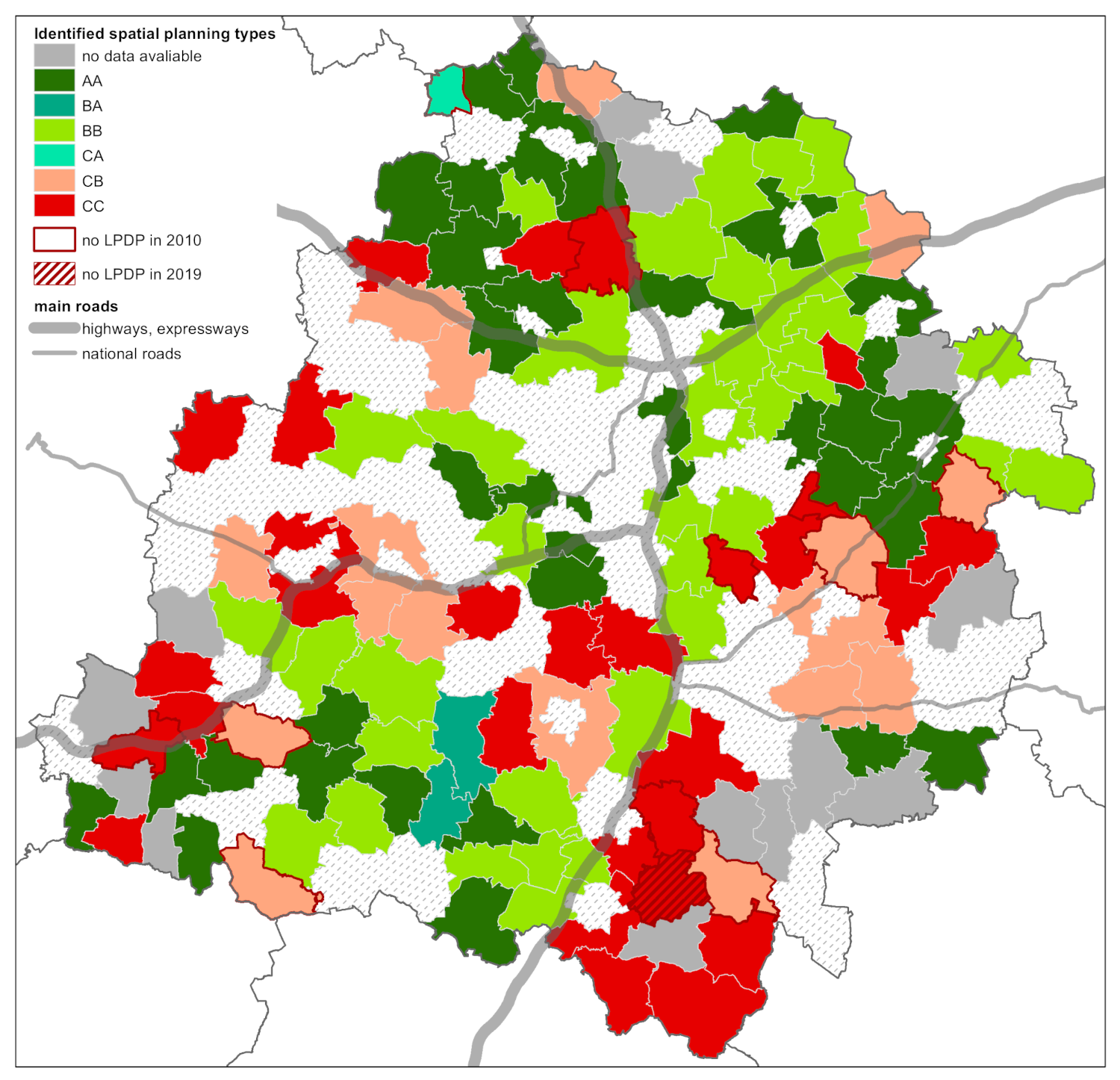
However, the positive trend noted does not apply to all gminas, and indeed the region’s spatial disparities in this respect are relatively large. To identify this, gminas were grouped in line with analogous cover intervals. Thus, group A had the best gminas assigned to it, i.e., those with areal coverage of 90% and more; while group B was for the authorities averagely successful in this respect (with 2–90% coverage), and group C brought together the gminas in the worst situation (given coverage below 2%). By comparing the designated the groups as they were applied at the two points in time, it was then possible to identify the six categories effectively characterising the kind of planning situation applied to rural gminas in Łódź voivodeship (
Figure 4).
In this way, Group AA encompasses the 35 gminas found to be in the most favourable situation, in that a high level of coverage was maintained over the decade. The “rural” gminas involved here are mainly seen to be those with a high degree of urbanisation, located within the agglomeration of the main city of Łódź, or around medium-sized cities in the northern part of the voivodeship that have started to benefit from a rapid improvement in transport accessibility (due to motorways), as well as geographical exposure in the direction of the national capital, Warsaw. Three further gminas (assigned to Groups BA and CA) reported a very favourable situation in 2019, having very much increased their level of coverage by plans during the 10-year period. In the case of two southern gminas, this is in fact linked with the better organisation of the planning situation around an area newly designated for the extraction of brown coal.
Finding themselves in the worst situation, as of 2010, were a total of 45 gminas, among which 17 (of Group CB) nevertheless improved their situation. In contrast, 28 gminas (of Group CC) continued to experience a very low level of planning—and the largest spatial concentration of these kinds of gmina are in the region’s south-east, which was identified in many different studies as a problem area from both social and economic points of view (Wójcik and Tomczyk 2015). An average situation as regards planning then characterises 37 gminas of Group BB, this in fact being the largest group, and one that encompasses gminas whose average planning situation has remained unchanged—or changed to only a limited degree—over a whole decade. Such inertia is particularly characteristic of those gminas in which agriculture has a major role in shaping the economic base.
4.3. The Digitalisation of Spatial Planning
The process by which spatial planning has undergone digitalisation was initiated by the adoption and implementation of the INSPIRE Directive, and was markedly accelerated just a few years after adoption. Overall data for Poland show that the numbers of Spatial Planning Instruments (
APPs) prepared in the form of georeferenced GIS or CAD datasets had already nearly doubled between 2014 and 2015 (
Figure 5). In contrast, there was a marked fall in the numbers of
APPs that were not digitised (remaining in the form of paper drawings or maps), as well as those whose utility in a digital version was limited, i.e., raster datasets with no georeferences that are basically scanned maps. During the period under analysis, there was something of an increase in the numbers of georeferenced raster datasets, which can be displayed via
GIS and
webGIS applications. However, the lack of possibility for any analyses to be performed on these ensures that this solution is now less and less likely to be chosen.
Obligations ushered in by 2020 amendments to the law on spatial planning include one that Poland’s units of local administration (gminas) should engage in the digitisation of APPs, with this entailing the entering of data, updating and steps to make the sets of data available. The provisions in question are as set out in supplementary Chapter 5a to the Act on Planning and Physical Development (16 April 2020), as well as the Regulation of the Minister of Development, Labour and Technology of October 26th 2020 sets of spatial data and metadata on spatial organisation.
At a minimum, the spatial data in APPs (including local plans) encompass: the location the given instrument encompasses—in vector form and in relation to the national coordinate system that is operating and in force, which attributes offering information on the given instrument, as well as the graphic aspect in a digital form with georeferencing—most often in Geo Tagged Image File Format (as based on the TIFF file format, if also allowing georeferencing information to be embedded within it). At the project design phase, digital APP data are revealed in documentation, and also updated according to need (not least so that public participation is supported and enhanced). In contrast, the actual diagram for the local plan is only an option where the GeoTIFF format is concerned.
Once a local plan has been enacted, there are 30 days for a digital version of that Instrument (or
APP)—obligatorily in
GeoTIFF form to be made available by way of the spatial information infrastructure in place. Furthermore, in accordance with the IIP Act (which implements the INSPIRE Directive in Poland), spatial information infrastructure is created as described with spatial metadatasets, and in regard to services, technical means deployed, and processes and procedures applied and made available by those units responsible for the co-creation of the infrastructure referred to in [
48]. When it comes to local plans that were established earlier but are still in effect in 2020, an arising obligation is that of the digitised version of these to be published within 2 years (i.e., by the end of 2022).
Furthermore, digital APP data are made available on the geoportals, representing one element of spatial information infrastructure. As the Head Office of Geodesy and Cartography (Główny Urząd Geodezji and Kartografii) launched the geoportal at the national level in 2005, different voivodeships began to bring their regional geoportals into operation, with gminas also launching their own counterparts at the local level. However, it has to be said that this proved an exceptionally tough task for most of them—and for rural gminas in particular. Indeed, the starting-up and subsequent servicing of geoportals was a luxury only the gminas with the necessary resources could permit themselves (with this seen to denote not only sources of finance, but also knowledgeable and qualified staff, and a suitable level of Internet access). This accounts for the circumstance whereby it was the large cities and the highly developed (and highly active) gminas that were the launchers of the first local geoportals.
However, since 2020, the Department of Spatial Planning at the Ministry of Economic Development, Labour and Technology was in a position to extend support to gminas for their digitisation of APP documents. Then, over only 4 months, the online service the Ministry launched was visited more than 100,000 times, while the APP plug-in was downloaded over 3500 times. The support offered with the aid of this service was based on free-of-charge (open source) GIS programming (known as QGIS) which allowed gminas—especially those that had still not launched their local geoportals—to lower the costs of digitising APP documents.
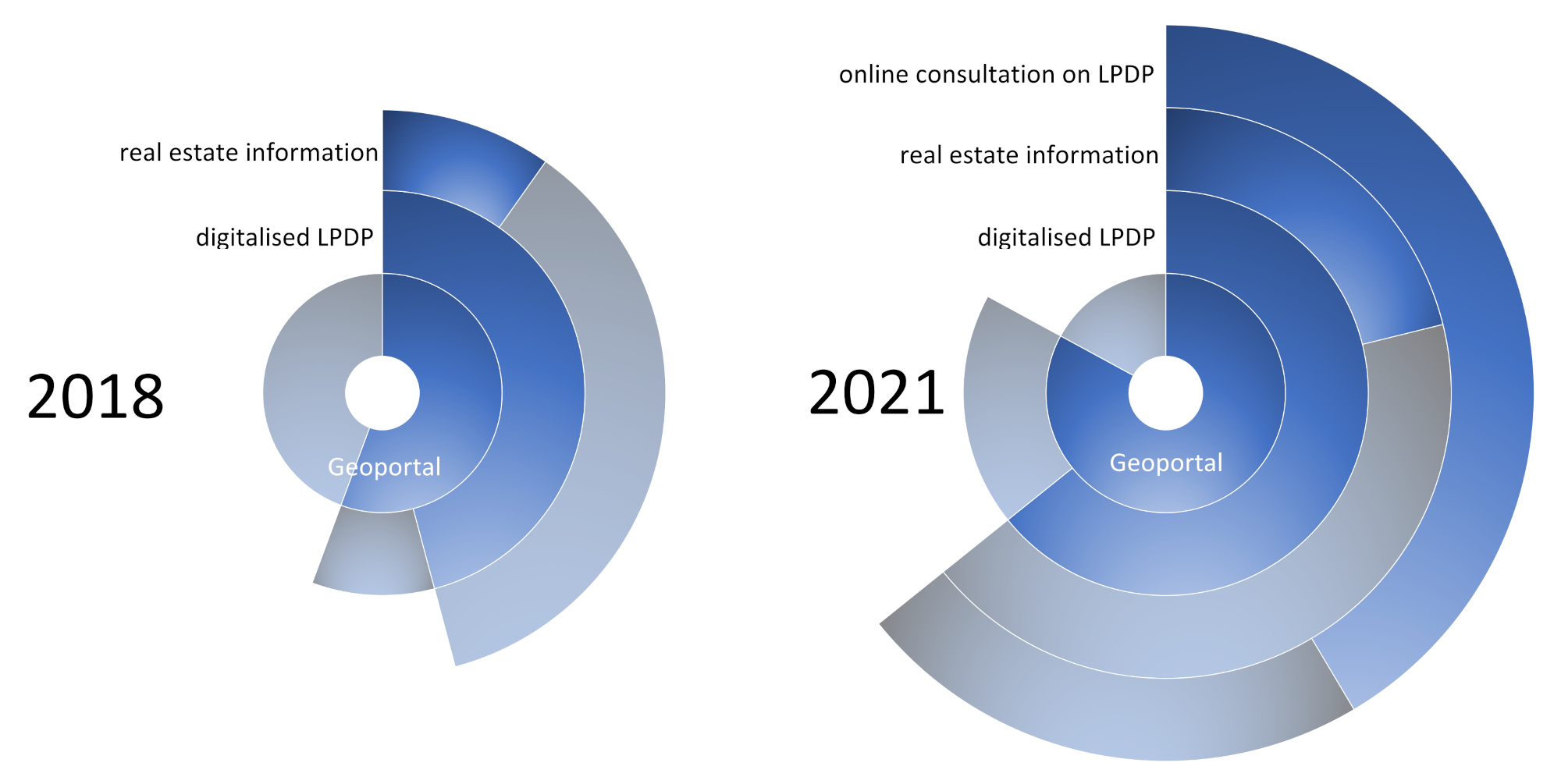
In Łódź voivodeship, as of the beginning of 2021, 102 of the 133 rural gminas had brought a geoportal into operation. This represents a more than 70% rise in the comparison with the year 2018 (when there were 74) (
Figure 6). A favourable trend was made plain by the comparison of the geoportals in the rural gminas of the Łódź region in 2018 and then again in 2020. Spatially conceptualising can be described as the filling-in of space in the region by gminas that make spatial information available via geoportals. This is especially the case for rural gminas located in the vicinity of smaller towns—for gminas within the zone of Łódź suburbs and around the region’s larger cities which had their geoportals as early as 2018. Furthermore, seemingly noteworthy is the concentration of gminas lacking geoportals that are located on the region’s eastern and southern peripheries (
Figure 7).
It is not just the case that the number of geoportals increased, as their quality and functionality are also seen to have improved—particularly in relation to spatial planning. The numbers of gminas making available a digital version of the map for the local plan (in the GeoTIFF format and with references to bases with relevant documents) increased by half (from 61 to 79), with the result that more than 60% of rural gminas now offer access to this service to their inhabitants. As well as allowing for the accessing of digitised APPs, geoportals also inform people on areas in which new developments are about to take place, as well as on real estate included within the local-authority “offer”. Such functionality is currently available on 26 geoportals (1/3 of those containing planning data); and it is another feature subject to favourable change, as in 2018, only every fifth geoportal with planning data also had information on what the given gmina was offering in relation to investment.
As of 2021, local geoportals were characterised by a new feature in the form of a module whereby users could become involved in the process by which a given Spatial Planning Instrument (APP) is made ready. This is therefore a concrete step in increasing the dimensions of public participation in the process. Indeed, this new function of a geoportal allows people to familiarise themselves with the listing of APPs and related individual projects that a given gmina is working on at the given moment. Furthermore, and most importantly, thanks to an appropriately generated form, the window of the browser can also support the direct incorporation of remarks in the course of a consultation process over a given document. Online consultation is actually available on 64% of the geoportals presenting APP data, with this representing almost 40% of all Łódź voivodeship’s rural gminas.
4.4. The Potential for GeoDesign
The compilation of information on levels of spatial planning, together with data on geoportal functionality (including those of the digitisation and dissemination of
APPs) supports the assessment of the potential to implement the
GeoDesign idea into spatial policy at the local level. The greatest potential is that enjoyed by the 30 gminas assigned to type A, which are characterised by a very high level of functionality of geoportals, as well as very good or good levels of spatial planning (
Figure 8).
Gminas with average potential to implement the GeoDesign idea have been assigned to type B, as subdivided into the B1 and B2 sub-types (where B1 includes 19 gminas with a very good planning situation plus portals of average-level functionality, though with an available online consultation option for planning documents, as well as gminas with an average planning situation, but very good geoportals). In turn, in type B2, we find 24 gminas featuring rather less-favourable indicators than in type B1, even as their portals have at least an average level of functionality. The last, best-represented type C (with its 47 examples) includes gminas that have geoportals, but do not use them to make available and work upon planning documents, on account of their very limited planning activity in general. Type C also includes gminas with good or very good planning situations that lack geoportals. This naturally leaves them with a very limited potential to implement GeoDesign. The spatial pattern characterising the potential for the GeoDesign concept to be implemented in rural gminas of Łódź voivodeship can thus be described as mosaic-like, though in this case, it is rather more distinct in relation to planning cover and geoportal functionality that the tendency to concentrate innovation potential around urban centres is to be discerned.
5. Discussion
The current debate over spatial policy is, i.e., concerned with the significance and role of universal and individual (regional and local) conditioning in terms of regional-development objectives. While rural areas in different parts of the EU have similar functional objectives (e.g., of an agricultural, transitional or multifunctional nature), it is where social and cultural fields are concerned that these areas have their specific development features, and historical paths capable of being followed [
49]. The same policy, and all the more so the development-related programme or instrument associated with it, triggers very varied reactions from the territories in different states and in different regions [
21,
50].
For more than 20 years now, many adherents to the idea look to EU policy to see a vision of the transformation that postulates the precise reconnaissance of local resources as a basis for the appropriate planning of future directions of development [
22,
23,
51]. This may be termed a neo-endogenous approach, and where Polish gminas are concerned, there is a link with the crisis that the modernist paradigm faced at the end of the 1970s [
52]. At that point, particular weight started to be attached to the specifics of an area as one element founding an original development path, often from the point of view of an alternative vision to that involving the top–down implementation of programmes [
51,
53]. The key question then becomes the identification of local resources and of their role in local development—as an important policy alongside the concept for regional development [
52,
53,
54], and with a fundamental objective of development relating to functional differences between economic entities and the stimulation of grassroot community initiatives [
55].
New concepts of endogenous development (which should take into account the smart village) point to significant linkage in local-community systems between effects in the form of higher quality of life and innovation, as well as research, knowledge and education [
56]. Such a conceptualisation places greater emphasis on territorial rather than sectoral policy, with this often being considered to contain different self-regulating impacts [
57,
58,
59].
In line with the neo-endogenous approach, an important factor underpinning change in rural areas is indeed community policy. The EU attaches great weight to social self-organisation at the local level, as well as to the quality of management and planning under conditions of the transfer of major resources of aid money whose goal is to even out opportunities for development [
22]. European Union policy, including the CAP, ascribes a particular role to matters such as the path of development adopted thus far, cultural and economic traditions, and social capital. It is also the openness of the European space that conditions people’s mobility (and that of capital), as well as (crucially for the development of European policy) spatial transfers of knowledge and know-how.
The impacts of migration and of new relationships within society constitute further important elements that stimulate innovation in the search for solutions in term of ideas, management, and a desire to raise the quality of life [
52]. The stimulation of defined activities as a mechanism by which to mobilise resources with the joint action of different rural actors ensures an increase in the significance of local communities [
60]. Hence, a conviction that the innovative nature of the concept of smart development lies in its focus on bottom–up social initiatives that work to improve quality of life through support for new digital technologies. The European Commission in the year 2017 proposed that the core concept of the smart village should be innovation in the search for solutions based around strong social capital and the generation of networks of links between stakeholders in the traditional way and by using digital technologies [
21]. It is for this reason that such an important role within the idea of smart villages is played by knowledge and information, as well as their transfer between key rural-development stakeholders.
The idea of smart rural development arising out of the neo-endogenous approach sees the essence of development as being the modernisation of public services and services rendered to communities by local authorities, on the basis of digital technologies being made use of. The objective conditioning of this modernisation includes the development of transport and communications infrastructure, especially the Internet. Investments made in rural Poland in recent years have been combined with the activity of many operators of cable or wireless surveys to eliminate the phenomenon of exclusion in relation to Internet access [
61].
When it comes to the use of the Internet, activeness on the part of the inhabitants of rural Poland is not found to depart from that characterising dwellers in small and medium-sized towns. While certain differences can be noted when the comparison is with the situation in large cities, these do not emerge as large enough to allow the situation to be described in terms of a civilizational gap [
61]. The current level of equipping of rural areas, and the opportunities provided by technological progress, establish a good basis for the introduction of innovative solutions that improve communication between the many different stakeholders in charge, and especially the relationship pertaining between local authorities and the institutions managing development on the one hand, and on the other, a public expecting transparency in decisions important to social, economic and spatial development [
22].
The introduction of the concept of intelligent development is very much a consequence of specific social and economic features of the given unit of administration. In turn, the specifics of each local community go a long way to determining the objectives where development is concerned, including the need to bring in innovation in a given area [
56]. The contemporary management of a gmina requires two kinds of competence: an appropriate level of digital competence among inhabitants on the one hand, and an advanced level of development of online public services from the local authority on the other. To a great extent, the matter of the introduction of assumptions of the intelligent development concept relates to specific features of a place, and to the resources with which it is blessed.
In the broader context, what counts here is a location in a given civilizational circle (i.e., at the continental, sub-continental or at least political-region levels). However, in the narrower context, importance is assigned to the topography of local resources and significance [
62]. Such a means of perceiving differentiation in space leads to a determining of the specifics of a place, through an indication of conditioning that would be needed for defined community and economic activity to emerge (including a capacity to attract investment, as well as influxes of defined kinds of resources in that context) [
63,
64]. Concepts relating to the specifics of a place emphasise the issue of steering specialisation in a given area. This leads to the repeated, one-off operationalisation of the notion of intelligent specialisation on this scale, while also pushing the role of the local authority in managing processes of development, i.e., from the point of view of the digital resources it has at its disposal. An innovative policy is also therefore seen to require the good management of spatial data on the many levels of organisation of work in the local environment to achieve smart development.
However, it is the introduction of innovation that takes in the development of spatial databases that determines a competitive advantage in a given area [
65,
66]. P. McCann and R. Ortega-Argilés [
67] here point to three key levels of development, i.e., embeddedness, relatedness and connectivity. Embeddedness is a sign of maturity of economic development, when factors of a financial nature are accompanied by cultural conditioning also playing a major role. Proximity and closeness are very strongly linked to the process by which knowledge is transferred. Economic and technological linkage (as well as that of a social nature) can be noted in the dissemination of information—as well as the knowledge developed on the basis of that. As B. Nooteboom [
68] notes, it is important to realise that information has no value if not up to date, and likewise if it is new but there is no basis or context for it to be understood.
Research results point to the important role of space in the transfer of knowledge, with this mainly ongoing at the local level, and even between neighbours, rather than on more-aggregated regional tiers [
69,
70]. The essence of linked communication lies in networking as a key feature of economic and social life, especially in an era of the rapid development of new technologies. On the one hand, there is spatial mobility and ease of decision making in regard to the migration of differing social and spatial rank; while on the other, there is virtual mobility and capacity to act or operate in a parallel reality [
67].
The mean value for the index of planning cover in the Łódź region (which, in fact, has changed little over a decade, if now above 35% at last—having crept up from around 32% before) corresponds with the mean values for Poland as a whole and is low. This seems challenging when it comes to any effort to achieve cohesive spatial development in a region [
71], and all the more so given the way values for the indicator actually differ rather markedly from one part of the region to another. The spatial differentiation for types of planning situation that characterise rural gminas allows for some very cautious conclusions- to be drawn in regard to the relationship between the levels and dynamics of local-government work in this domain and geographical location. Given its genesis, the Łódź voivodeship is a typical product of the Industrial Revolution, and the way that this brought a dramatic increase in the size of one city (Łódź itself)—as the remaining regional space rapidly became subordinated to it [
72]. The settlement network here thus has functional features allowing it to be included among territories with a clear division into a centre and a periphery.
Work on disparities in levels of economic development among rural areas of the Łódź voivodeship evidence a dependency relationship between the level of urbanisation and the degree of advancement of the development process (as with gminas’ financial situations, levels of multifunctionality, entrepreneurship, etc.) [
73]. The referencing of the planning situation to geographical differentiation in the level of economic development allows some very general regularities to be defined. This means that awareness of the role of spatial planning based on digital resources depends on the economic situation of the given gmina to some degree only. An ever-greater role is being played by processes of good governance based around respect for the law and ordinances issued in this sphere, and the awareness of the influence of new instruments on opportunities to accelerate development and knowledge.
The example of the Łódź voivodship shows all this very well, given that it can be termed “transitional”, as it is in the process of bringing into sharper relief a new order based around the capacity of stakeholders to generate new knowledge and shape new skills in an era of widespread and ultimately universal digitalisation. Spatial differentiation in the planning situation assumes a mosaic-like configuration, with this pointing to the major significance of the approaches gmina-level authorities take to legal guidelines, as well as the role of the plan in the shaping of territorial structure. In essence, it is only among gminas in the best and worst situations that we might point to the role of classical factors of development founded upon location in physical space (and relating to the physical distance and degree of separation in space).
The spatial distribution of gminas utilise geoportals points and make these available to two regularities when it comes to the development of the planning situation. In the first place, there is a steady “filling-in” of rural space with land that geoportals have. It is usual for there to be a centre–periphery direction to the diffusion of new planning instruments, allowing for transparent knowledge-acquisition in regard to current forms and trends in the development of spatial management and physical development. The most shortfalls in this regard are related to gminas in the south of the region, with their more problematic social and economic situations.
Delays in this respect can be seen as examples of path dependence fixing unfavourable development trends (whose source can be looked for in growing spatial peripherisation). The present (transitional) planning situation in rural parts of the region allows for the quite clear indication of internal peripheries, as well as an overcoming of certain unfavourable trends in development, thanks to the ongoing digitalisation of public services [
74].
The second regularity concerns the growing functionality of geoportals, especially when it comes to shaping transparency in planning processes for local communities. The result is progress with a culture of trust towards those in authority, making co-participation in the management of gmina space a real possibility. This is of particular significance to rural gminas that interpret increased investor interest as a potential future location of activity.
The digitisation of data is thus coming to represent more and more of a chance for the potential of a voivodeship centrally located within the transport network to be made use of. The enhancement of the functionality of geoportals so that they allow for public consultation will facilitate the gathering of information on public sensitivity to given proposals for changes in spatial organisation that local authorities come up with. A right of inspection of materials is extended to all stakeholders, and that can help many social conflicts over space to be avoided. Good practice in this regard (as supported by appropriate legislation) is about a steady augmentation of rural areas, not only when it comes to wide-ranging possibilities for observation and the assessment of the planning situation, but also in communication with the public. The gminas in different parts of the region that began with this process at an earlier stage (be they centrally located or peripheral pioneers of digitalisation) have been in a position to raise their level of competitive advantage over others. It is possible that a new line of territorial division may arise from this, but this will be one less obvious than that set out in theories of regional development, involving, for example, a centre versus periphery.
The relatively high level of digitalisation of spatial planning processes confirmed for certain rural gminas of the Łódź region offers a starting point (if also a prerequisite) for the introduction of a
GeoDesign “philosophy”, which is associated, in terms of its genesis, with the scenario planning instrument that achieved popularity during the 1990s [
75]. However, the growth in the significance of this notion and approach, as can be observed since the beginning of the new millennium, reflects the spread of the digitalisation of planning processes [
76,
77].
GeoDesign has thus offered a way of recognising a whole new way of thinking on the use of GIS as a geographical design framework [
78]. The “geo” component was related to geographical space, but this concept creates bases for an extended conceptualisation of space, i.e., a move from 2D to 3D and 4D. The essence of this transition lies in the collection of spatial data on as many types of social and economic activity as possible. It is this extended and enhanced review that is built into the new concept, with the community being the user of the knowledge that arises out of it, which becomes geospatial.
The “design” component is, in turn, of an ideological nature and denotes matters of vision and planning activity, as well as the object of spatial planning that is the community rooted in the given area. The essence of the objective here is thus to define a project that gels with experiences of the given community, and thereby also the needs that the people involved have identified. This is how the
GeoDesign concept pays attention to local knowledge, and thanks to it, members of local communities assume the status of true “experts”.
GeoDesign is defined as a “hunch” or even “premonition” underpinning efforts to have rational analysis conducted—as the design way of thinking often jumps discontinuously from one matter or aspect to another as it searches for solutions.
GeoDesign is also multi-levelled in the sense that systems overall, sub-systems and even minor details must often be taken account of at the same time. This leads to a tangible process of temporal and spatial pursuit of the entity being designed. The object involved may be an area, temporally ongoing event or spatial relationship, and each spatial fact may be designed or created with intent and objective. The whole thought process encompassing the founding of a spatial plan confers form upon it, whether that be physical, temporal, conceptual or relational [
79].
Fitting perfectly within the concept of smart rural development—as it indeed does—
GeoDesign opens up new possibilities for spatial planning on the local scale. However, a prerequisite for its implementation and pursuit is the achievement of a high level of digital competence by the stakeholders in the process. Of key significance here is awareness on the part of local authorities, who should seek to cross the barriers beyond which a community can become a simultaneous creator of a planning process in the circumstances of the rapid development of digital technologies [
80].
6. Conclusions
The authors have here sought to assess the level of digitalisation achieved by spatial planning in Poland’s Łódź region. The positive trend noted and generally occurring favourable direction of change in planning coverage are of major significance in the context of smart rural development. The presented research clearly points to the rapidly increasing number of geoportals, as well as their quality and functionality, which are also seen to have improved. Digitalisation leaves the planning process more transparent than before, offering one way in which civil society may better control the institutions making local law in the relevant context. The fuller inclusion of civil society and the public helps release human creativity, with digitalisation in a position to achieve greater mobilisation and engagement on the part of a larger number of stakeholders. All of this brings spatial planning closer to achieving the GeoDesign model. We show, nevertheless, that even as the process is indeed accelerating, the spatial regularities involved are not so obvious, being related, not only to geographical location, but also to social capital, and the sense of responsibility felt by people in the given place.
The work carried out points to a differentiated degree of digitalisation of the process of spatial planning in Poland’s Łódź region. That said, it is obvious that the methodology adopted here corresponds to the specifics of Poland’s planning system, and—bearing in mind the variety of formal and legal conditioning of rural planning in other countries [
3,
41,
81,
82]—the pursuit of comparative research would require the adaptation of the methods applied to the different conditions present in other given countries. However, it is nonetheless reasonable to believe that the results obtained, and presented herein, are of significance in a wider context. Irrespective of the specific or precise nature of planning tools, the digitalisation of the planning system does increase the potential of rural areas to adopt smart rural development, with the further prospect of a transition to a new philosophy for the shaping of territory based around the concept of
GeoDesign.
There can be no doubt that digitalisation, as it relates to spatial planning, is one of the many strands to a wider digital transformation taking place (or at least now capable of taking place) in rural areas—in some cases since the 1980s. The debate relevant to this has meanwhile taken up various of the strands referred to. The problem of the availability of universal high-speed broadband has in fact determined opportunities for the digital transformation of rural areas for many years now [
83,
84,
85,
86]. However, the development of technology—via the 5G network, the greater operability of smartphones and widespread adaptation of content present on the Internet for viewing by means other than computers (i.e., on phones, tablets or even smart TVs)—is now ensuring the reduced significance of the issue of broadband access [
87,
88,
89]. Similarly, there may very soon be changes in traditional spatial patterns by which the level of development and digital transformation is a reflection of the remoteness and topography of rural areas treated as peripheries vis-à-vis urbanised areas [
28].
The obtained results contribute to discussion around the issue of the digitalisation of rural planning, of which one manifestation might be the implementation of the
GeoDesign concept. On this basis, research presented for just a single region in Poland may nevertheless prove to be of value for many other rural areas in Europe (and indeed beyond). It also needs to be stressed that the broader context for the research carried out falls within the framework of
Geodesign considerations, as well as those relating to modern participatory models of spatial planning [
90,
91,
92], and the potential demonstrated for smart rural development to be achieved [
93,
94]. This can, in turn, permit and sustain the pursuit of further research that investigate the questions raised below in more detail.
Within the region under study, rural gminas adopting a development path based on the smart development concept could, to date, break away from a spatial order by force, and were founded upon differentiation and disparities between regions of a centre-and-periphery character [
25]. Today, classic studies based on land-management and human-capital variables [
95,
96,
97] constitute one of the interpretations of development. Digital technologies steer the order of spatial development in a more mosaic-like direction, with configurations of development more and more dependent on social capital and efficient management, including where the implementation of the smart development concept is concerned.
Knowledge and resources regarding skills are thus a factor in a position to revolutionise the Polish countryside, with the Internet occupying a greater and greater role in this [
62,
98]. The Internet operates to limit the sense of both social exclusion and physical distance [
99,
100,
101]. However, it is important for any exclusion in this regard to be curtailed. Inclusion within processes of development thanks to online access helps generate an active community, while also improving the level of scrutiny over what those in authority are doing. Intelligent development enhances local-community motivation to engage in the joint management of a given area and its planning needs. The use of digital technologies also engenders opportunities for chances of development to be equalised, with this leading to a fairer transformation of rural areas and increasing their quality of life [
102].


